Homolovi State Park, near Winslow, Arizona April 16, 2025
We’re camping for two weeks in Homolovi State Park, just a couple miles east of the town of Winslow, Arizona (pop. 9,005; perhaps you’ve heard of it – one of its street corners is mentioned in the Eagles’ first major hit from 1972, “Take It Easy”). This is our third time staying here in three years – we really enjoy it. After spending five months wintering in Las Vegas, Nevada, and then a couple of campgrounds on Interstate 40 in Arizona, we’re appreciating the quiet environment and dark skies of this state park (not that we didn’t have a good time in Las Vegas; in fact, we’ve reservations to be back there beginning this November).
The main feature of this state park is a cluster of four major ancient Native American villages, several miles apart and all built and occupied around the years 1290-1400. The villages were then abandoned, but it’s generally understood that the people who lived here eventually became what is now the Hopi nation – one of the tribe’s reservations is about 60 miles north of present-day Homolovi State Park. The four villages are designated Homol’ovi I-IV; the name of the state park doesn’t include the apostrophe of the village names. “Homol’ovi,” in Hopi, translates to “place of the little hills,” and the Hopi also refer to the city of Winslow as “Homol’ovi.”
The Hopi call the people who lived here – most likely their ancestors – the Hisatsinom, which means “the people of long ago.” During the period in which the Hisatsinom lived in this region, they built and occupied four or five large villages – some comprising hundreds of rooms – using rocks gathered from the ground.
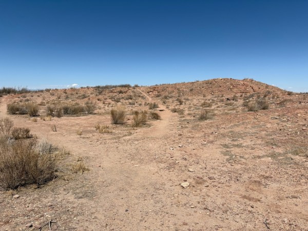
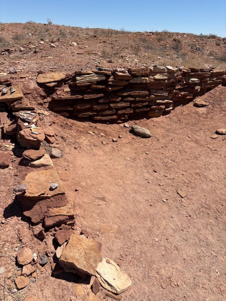
The Little Colorado River, a watercourse that drains the Painted Desert area of northeastern Arizona, flows through Homolovi State Park. I took this photo while Nancy and I were driving to Winslow; the perspective is looking north from a bridge on the former U.S. Route 66 (and now Arizona State Highway 87). The trucks and trailers just on this side of the horizon are on Interstate 40. The Little Colorado River’s headwaters are in the mid-eastern region of Arizona, very near the state’s border with New Mexico. It then flows almost 340 miles in a northwestern direction until it empties into the Colorado River in the Grand Canyon. The river flows from its headwaters all the way to the Grand Canyon only during periods of flash flooding or heavy snowmelt; much of the year it’s a braided and puddled wash. I took this photo the day after the area got some appreciable rain and snow, and the water level rose only marginally. The occasional flash flooding of the Little Colorado River, which swept away crops and structures, is probably why the Homol’ovi sites were abandoned in favor of the area further to the north and which the Hopi call home today.This is the site of a major native American village, known now as Homol’ovi I, that was last occupied about 600 years ago. At its peak, it contained about 1,100 different rooms constructed of rocks. Some of the rooms included three stories. Over the ensuing six centuries, a lot has happened to destroy these unoccupied villages. Dependable northern Arizona winds have covered the village with dirt and sand, but some structures, such as the one on the mound at the right, can still be discerned. Many of the rocks in the structures were taken by members of a nearby Mormon community in the late 1800s for use in their own buildings, and vandals have also destroyed the buildings and looted the pottery.
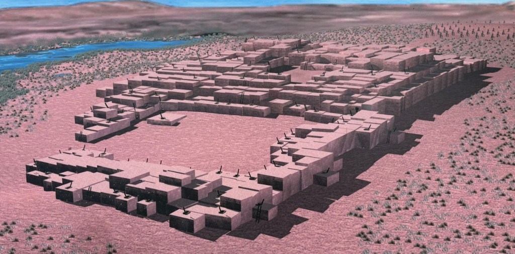
Take a look at the tall plants on the horizon at far left: directly to the right of them, you’ll see some white splotches (not the clouds, which are further to the right; the smaller white splotches of which I write are immediately to the right of the tall plants). Those are the San Francisco Peaks, still snow-covered in mid-April. The town of Flagstaff, Arizona, is at their feet. Those mountains are about 65 miles west of Homolovi State Park.I took a picture of this image, an artist’s depiction of what Homol’ovi I looked like at its peak, at an information kiosk near the site of the former village. That’s the Little Colorado River in top right. The original image gives credit to Douglas Gann of the Center for Desert Archaeology.
From about 1290 to 1360, it’s believed that Homol’ovi I grew from a village of 200 rooms to more than 700. Around the year 1360, the village now known as Homol’ovi II was established about 3 miles, or 5 kilometers, north of Homol’ovi I; that second village quickly became the biggest one in the cluster at 1,200 rooms. Homol’ovi I, however, benefited from the second village’s success, and grew to a maximum of 1,100 rooms.
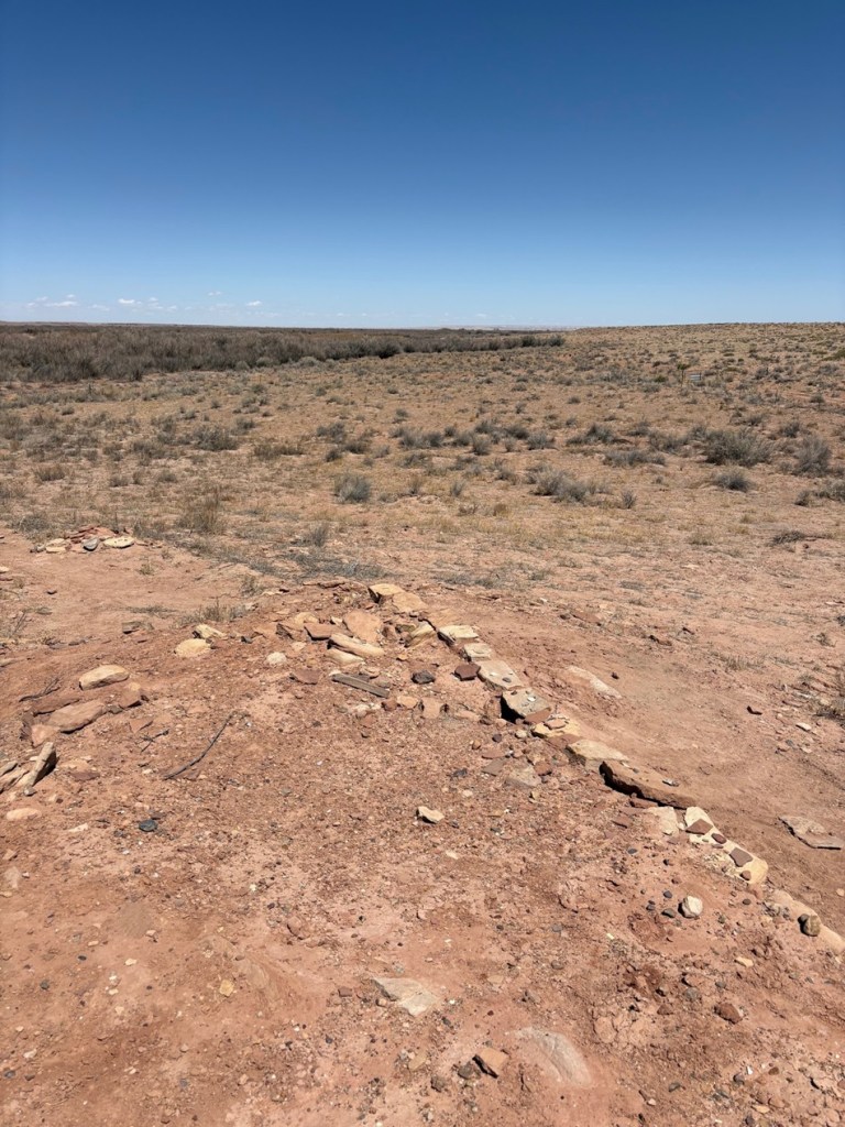
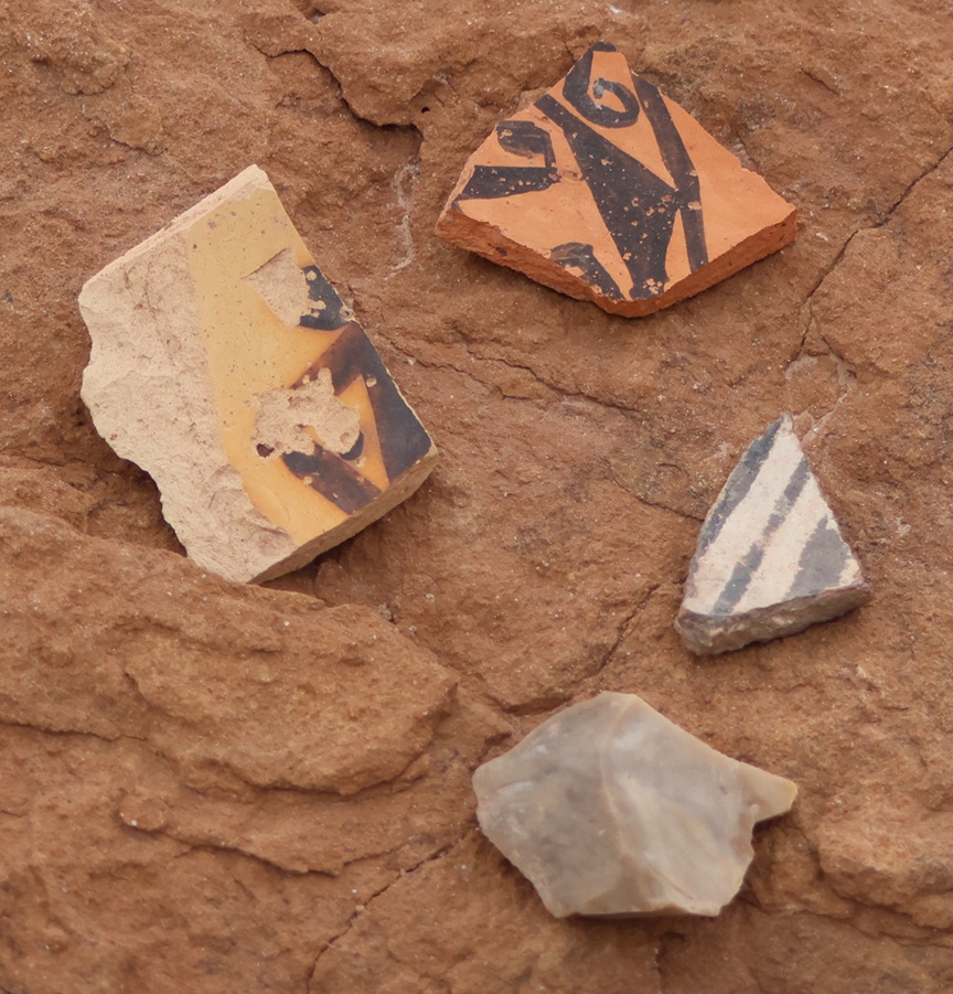
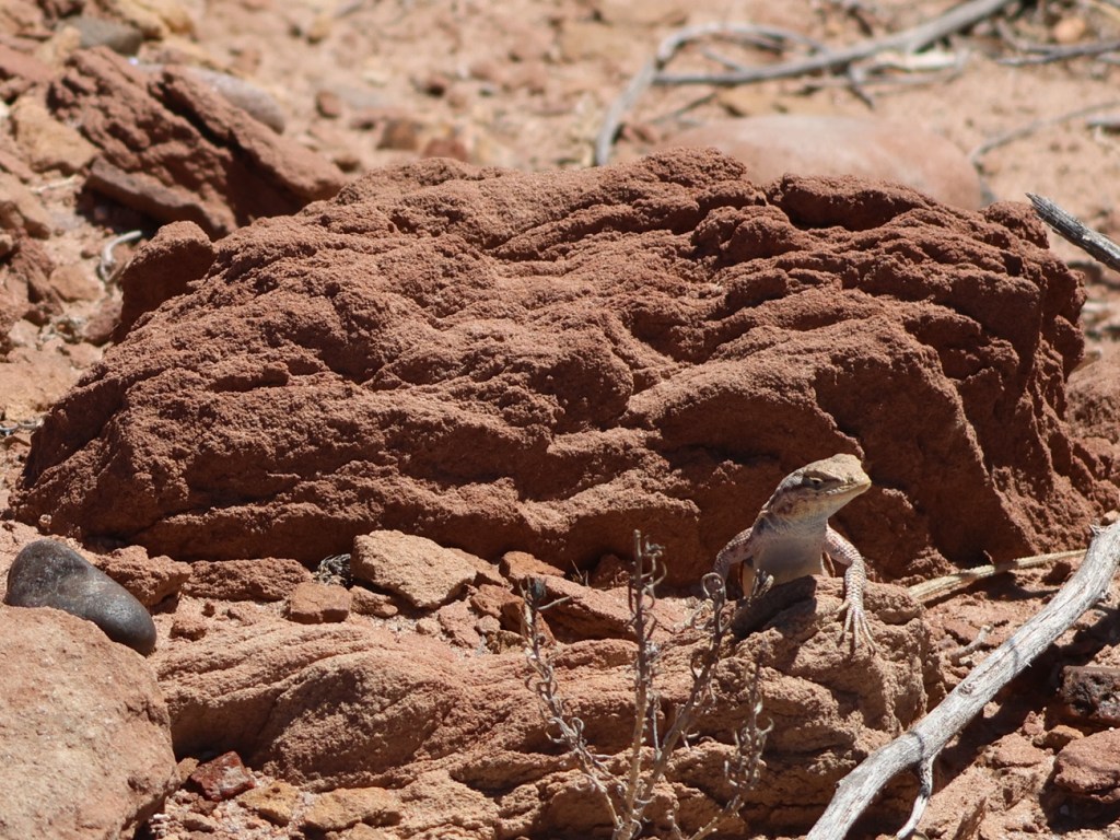
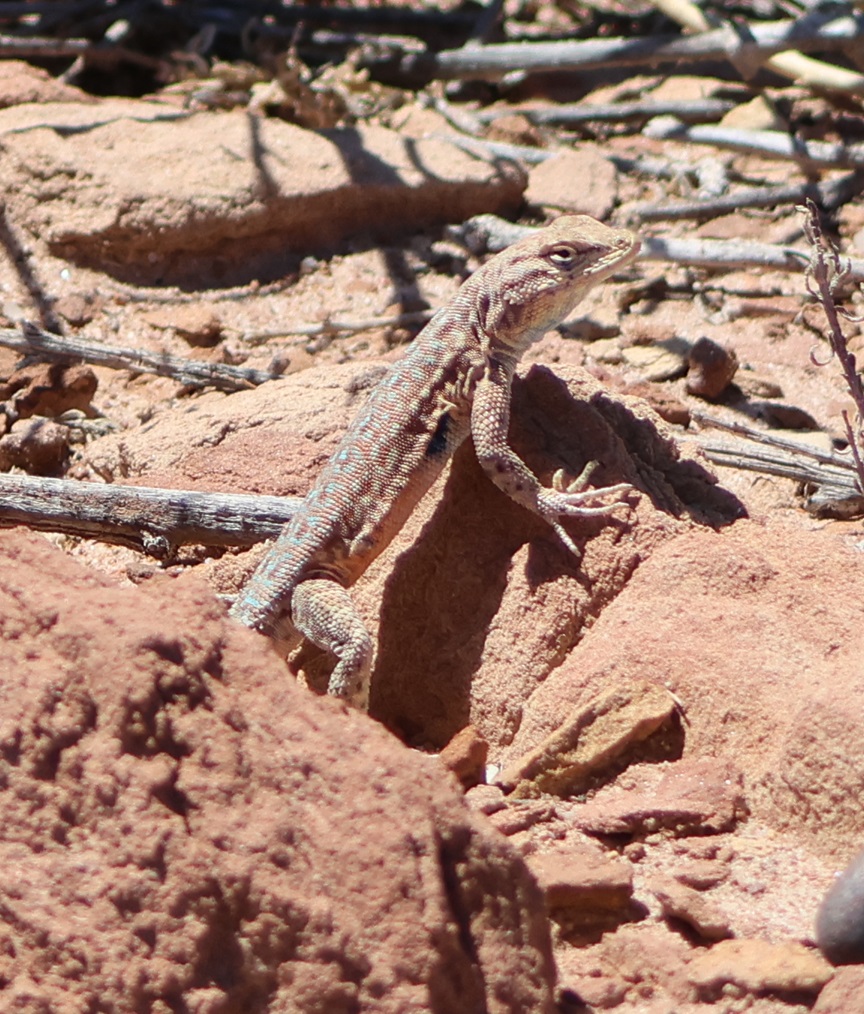
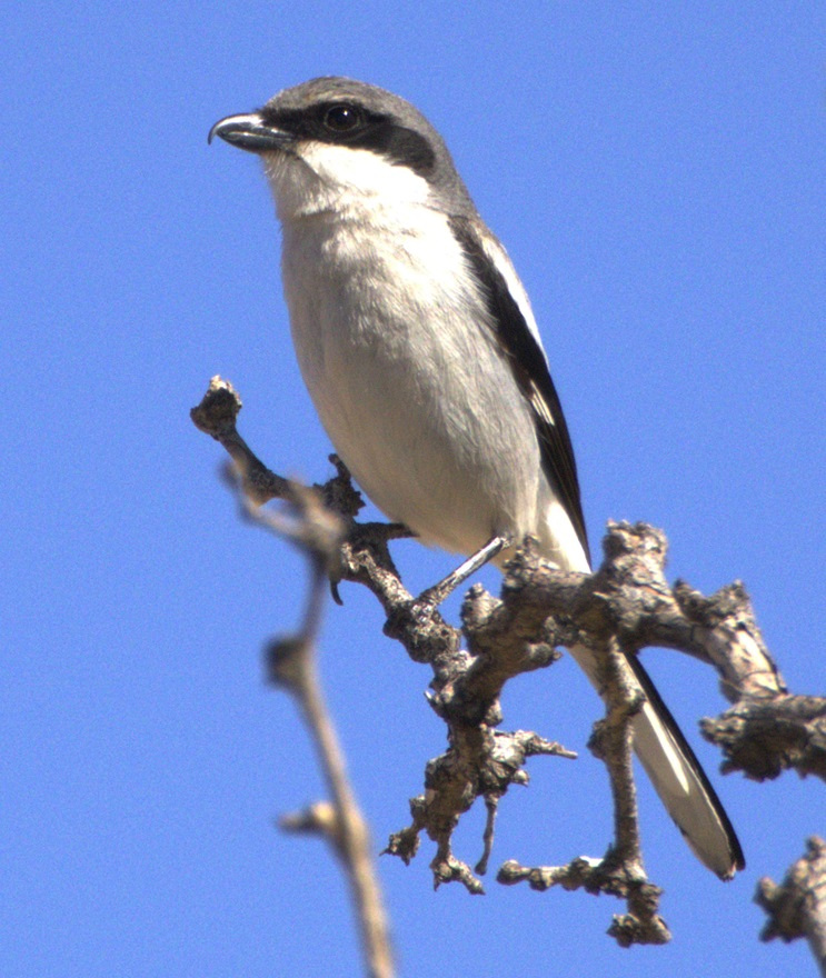
This photograph was taken from the top of the hill shown in the previous photo, still looking to the northwest. The rocks in a line are the former wall of a room. The trees near the horizon are on the east bank of the Little Colorado River; it was that river’s occasional flash flooding that likely led to the abandonment of Homol’ovi I and the other villages 600 years ago.This is a small grouping of pottery shards and what appears to be a hand-shaped rock, taken from the ground at Homol’ovi I and placed on a larger rock. The pieces of pottery are roughly the size of an American half-dollar. There are thousands of shards like these at the site, and most of them are on larger rocks like this. Archeologists and conservationists prefer that people don’t do this; instead, simply leave the shards on the ground.This is the largest exposed wall still standing at Homol’ovi I, and it’s been almost entirely rebuilt by archeologists. Note the small collections of pottery shards on some of the rocks at left: don’t do that.THIS IS A TALES OF THE GODDARD LIZARD ALERT. This little guy (and he is a guy, and I’ll tell you why I know shortly) caught my eye as he scampered across the rocks and sand of Homol’ovi I. He is a side-blotched lizard, a genus (Uta) of which there are now seven species, and he and I were to have kind of a neat interaction. This photo of my new reptile pal shows why the genus is called side-blotched lizard – observe the dark mark (or, in scientific terminology, “blotch”) on its side just behind its front leg. The turquoise-blue dots on the back are also a defining characteristic of the genus. These lizards grow to a length of about six inches, including the tail. Their diet includes insects, spiders, and other arthropods such as the occasional scorpion. They are themselves predated upon by larger lizards and roadrunners.In an attempt to give the reptile some space, I continued walking down the path through Homol’ovi I – but the beast pursued me. Observe the very pretty light-blue dots on its back. I was about six feet from the lizard when I took this photo (using a 400mm telephoto lens).Here’s a cropped version of the previous photo. Behold those beautiful blue dots as well as some detail of its fearsome front claws. After I took the photo, the lizard continued to approach me: in fact, it got to about six inches from my left foot – and then it scampered away. Turns out, that’s a common behavioral trait of male side-blotched lizards. The scientists don’t know if the behavior is intended to scare away possible intruders from its mate, or to defend its territory. At any rate, I got the hint and moved along (even though my course on the path took me in the same general direction of the lizard, who at that point was many yards away). I later described my interaction with the side-blotched lizard to Nancy, who did not at all appreciate when I poked her under her armpit to show her where the blotch on the lizard’s side was. We also shared the same belief that she would have absolutely and completely freaked out if the lizard had gotten to within six inches of her left foot.More wildlife: I always like to include some bird photos in these postings, so here are a couple of images I took in our campground at Homolovi State Park. This is a black-throated sparrow (Amphispiza bilineata), a species found in the southwestern United States and much of Mexico. They are absolutely beautiful little birds. I’ve seen them only here at Homolovi State Park and at Tuzigoot National Monument, further west in Arizona.This is a loggerhead shrike (Lanius ludovicianus), on a tree just a few feet from the Goddard’s campsite. I remember reading about shrikes when I was young, but I didn’t see one in the wild until a couple of years ago at McDowell Mountain Regional Park east of Phoenix, Arizona. I also saw some over this past winter at Clark County Wetlands Park, very close to the campground where we spent the winter near Las Vegas. Loggerhead shrikes are found nearly all over the United States.
We’re planning to join a ranger-led tour of Homol’ovi II, which has been partially excavated and reconstructed, on Saturday, April 26. I’ll write and post photographs from that experience afterwards. We were on the same tour a couple of years ago, but, because of our travels and opportunities to see ancient Native American sites in the southwestern United States since then, we have a better perspective of what we’ll see.
As we were walking away from my first viewing of the Grand Canyon, I turned to Nancy (who’d been to the national park on a hiking trip with friends some years earlier) and said, “I wasn’t prepared for that.”
And that was an understatement among understatements. I’d seen countless photos, as well as tons of video footage and movie clips, of this geologic wonder, and I was woefully unprepared for just how stunning the views are when one is actually standing on the rim of the Grand Canyon. More than a year later, while editing the photos for this blog posting, I am shaking my head at the images and believe me when I tell you: my photos don’t do the Grand Canyon justice and neither do anyone else’s.
“In the Grand Canyon there are thousands of gorges like that below Niagara Falls, and there are a thousand Yosemites. Yet all these canyons combine to form one grand canyon, the most sublime spectacle on the earth.”
– John Wesley Powell, 1895
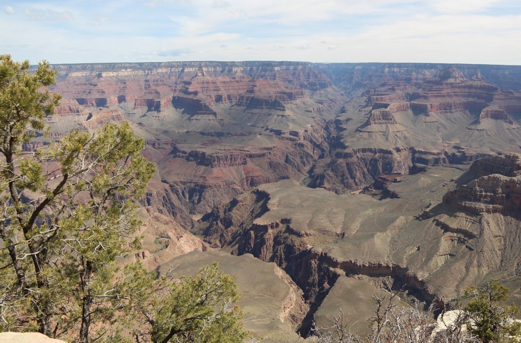
This is the first photo I took from the rim of the Grand Canyon. The views are so expansive, both in distance and depth, that the light from the sun and shadows from cloud cover change what you see from minute to minute. The average width of the canyon from the South Rim to the North Rim is 10 miles. The different colors in the rocks are due to the presence of varying minerals, such as iron oxide, in each layer.
Grand Canyon National Park: By The Numbers
Date established
January 11, 1908 (national monument); February 26, 1919 (national park)
Total area
1,902 square miles
Total visitors
4.73 million in 2023
Elevation
South Rim: 7,129 feet (elevation of North Rim is 8,145 feet); elevation of Colorado River is 2,400 feet
The Grand Canyon’s dimensions are so big that the numbers are related in miles, not feet. Consider that the state of Colorado measures 280 miles from its northern border with Wyoming to its southern border with New Mexico. The Grand Canyon, at 277 miles long, is only three miles shorter than that distance. The width of the canyon is an average of 10 miles. It’s nearly one mile – an average of 5,000 feet – from the rim of the canyon to the Colorado River below.
Here’s something about the Grand Canyon that I find really hard to fathom: the scientists believe that the canyon is only 6 million years old. In geologic time, that is less than the beginning of an eyeblink. Prior to the 1966 completion of Glen Canyon Dam, upriver from the Grand Canyon, during spring and summer runoff hundreds of thousands of tons of sediment would be carried by the Colorado River – each day. That water, pushing and pulling and tossing sand, gravel, rocks, and boulders through the canyon, gouged what is now a mile-deep course through what is now northern Arizona. The erosional forces also included precipitation and freezing and thawing of water along the canyon’s walls.
Early European-American residents of the American Southwest recognized that the Colorado River had to be tamed in order to prevent it from wiping away those resident’s properties during spring and summer floods. Creation of the national monument in 1908 and eventual designation of Grand Canyon National Park in 1919 assured that no manmade water diversion projects would be constructed within the boundaries of the park.
This is the second image I took of the Grand Canyon. The multicolored and clearly delineated rock layers, including sandstone, limestone, shale, schist, and others, range in age from 2 billion years old at the bottom of the canyon to 250 million years old at the top, nearly one mile above the Colorado River.
Beginning from Lees Ferry on the east to Grand Wash Cliffs on the west, the Grand Canyon measures 277 miles in length (at 280 miles, the state of Colorado is 3 miles longer from its northern to southern borders) . Two great manmade structures bounding the Grand Canyon, Glen Canyon Dam and Hoover Dam, create two immense reservoirs, Lake Powell and Lake Mead respectively, to manage the Colorado River’s water flow.
As it flows through the Grand Canyon, the Colorado River has an average depth of 35 feet and a width that varies from 76 feet to 300 feet. During normal operations of Glen Canyon Dam (and when the American Southwest isn’t enduring its ongoing decades-long drought), almost 130,000 gallons of water moves through the canyon’s inner gorge every second – enough to fill an Olympic-sized swimming pool in 5 seconds. The volume of water released through the canyon is often dependent on municipal electricity demands from cities as far away as Los Angeles. The Colorado River used to flow 1,450 miles from La Poudre Pass in Colorado’s Rocky Mountain National Park all the way to the Gulf of California; municipal and agricultural demands on the river in the southwestern United States cause the river to gradually dry out shortly after crossing into Mexico.
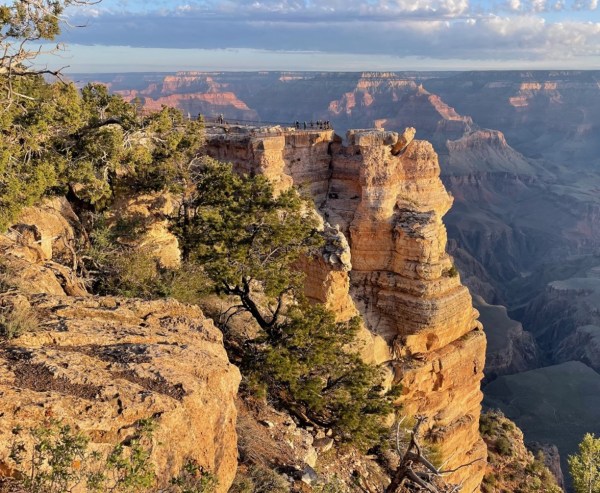
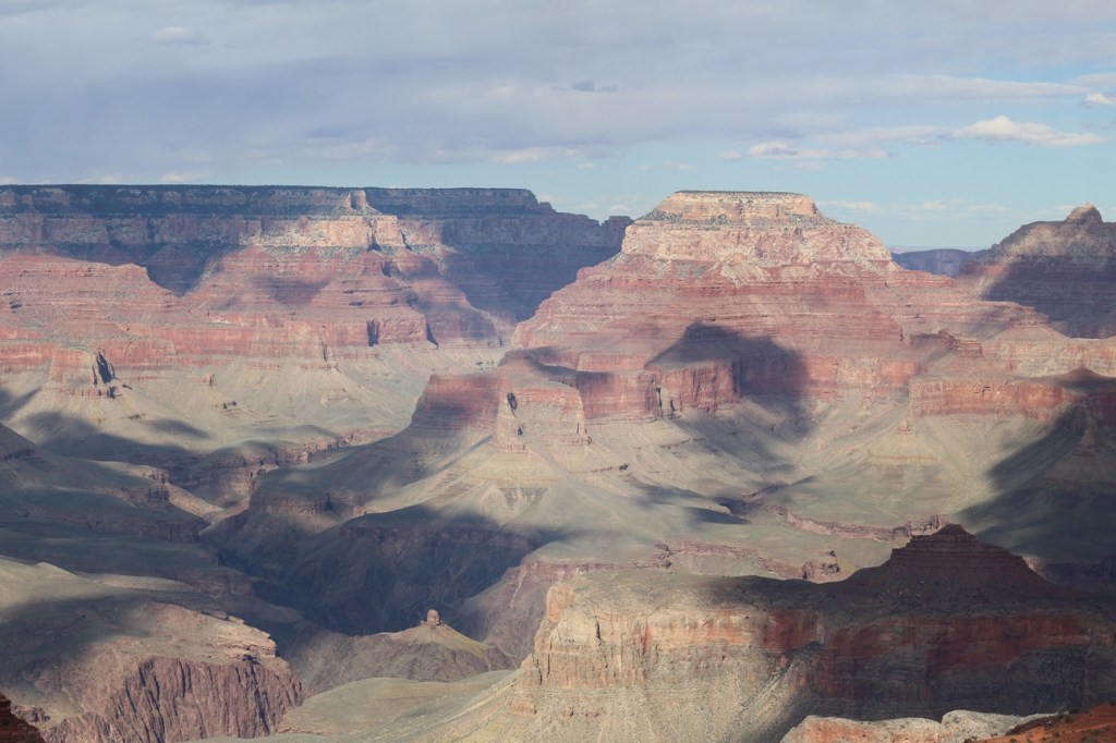
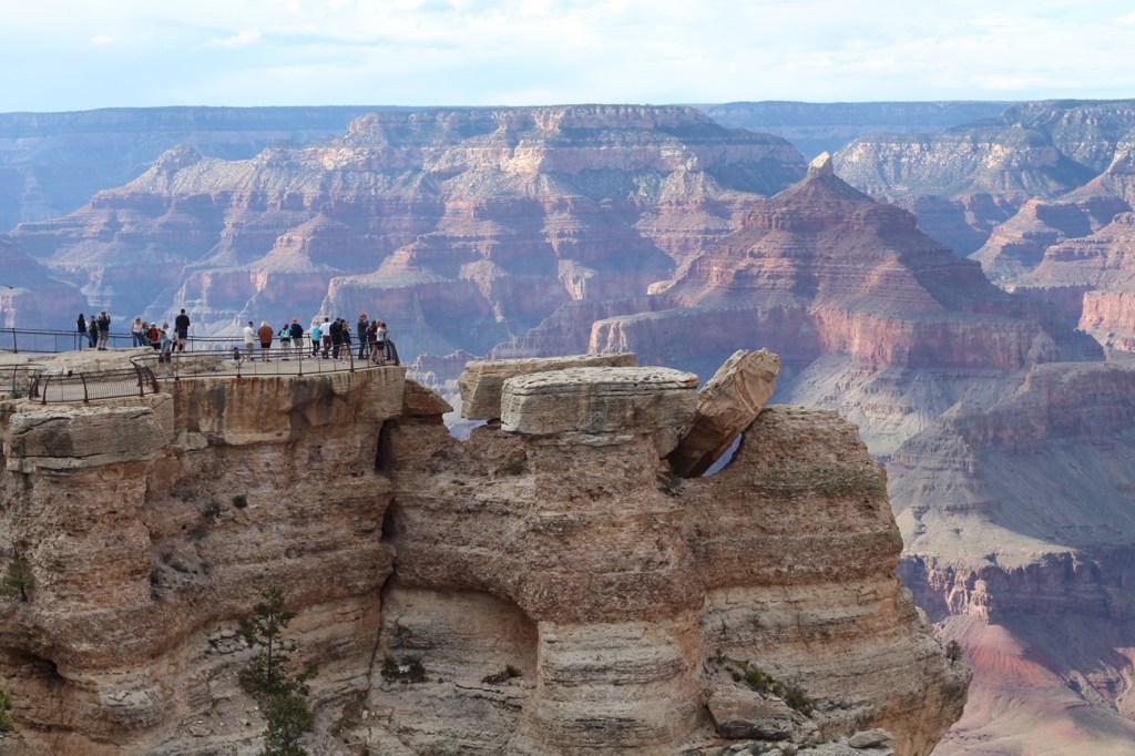
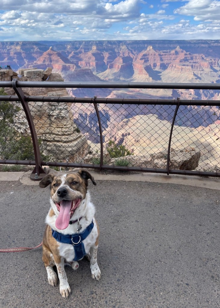
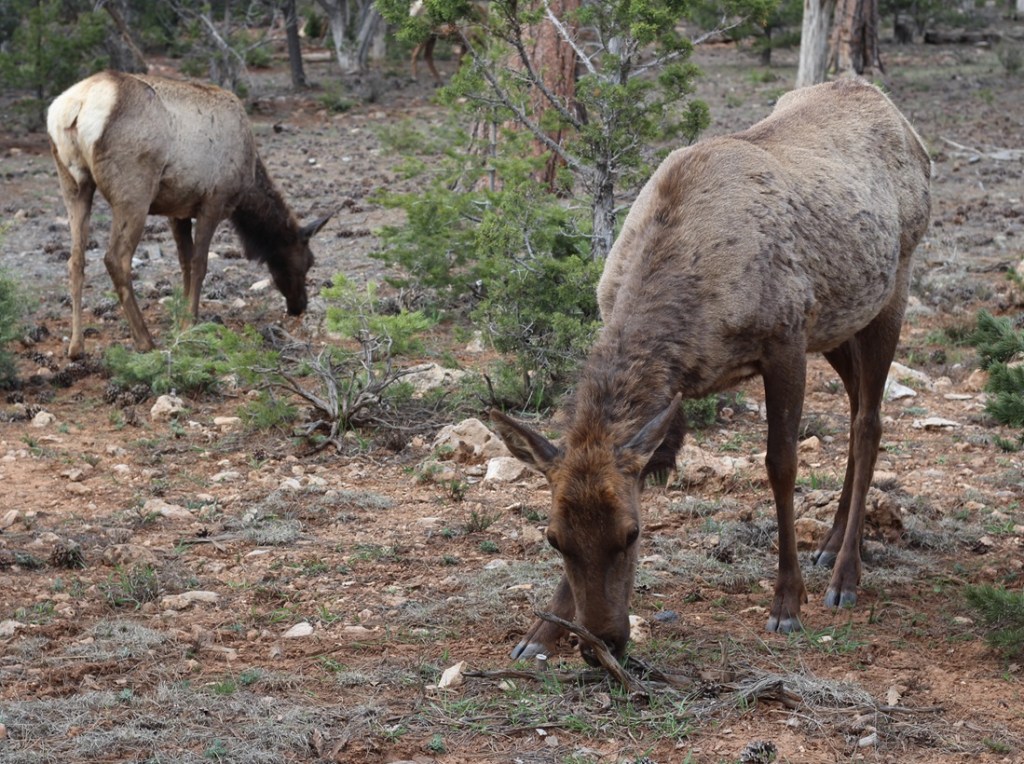
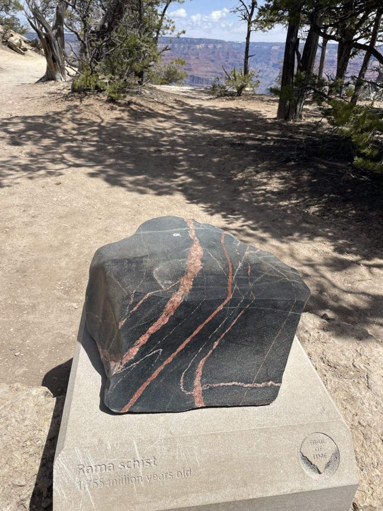
We’ve all seen plenty of canyons across the country and around the world, most of which are easily identifiable by the watercourse that originally carved them. But, in many places, the Colorado River isn’t visible from the rim of the Grand Canyon – there are too many smaller canyons, many of which would be significant geologic features on their own anywhere else – that block the view. The Grand Canyon is a supercanyon of canyons. (This is the third photo I took of the Grand Canyon, by the way. I took hundreds. I won’t post them all, I promise.)Here, then, is the fifth photo I took of the Grand Canyon. We weren’t the only visitors to the national park that day. This is a group of people at Mather Point, one of the larger overlooks that extends into the canyon. Clear days at Mather Point provide views of up to 30 miles to the east and 60 miles to the west. The overlook, along with a campground in the national park, is named after Stephen Tying Mather (1867-1930), the first director of the National Park Service.Here we see a visitor (it’s Gunther) to Grand Canyon who, like me, is experiencing his first few hours at the national park. Gunther was able to join us on our first visit to the canyon’s South Rim, which has a mostly paved walking trail extending 13 miles. That’s Mather Point in the left mid-background.At an elevation of 7,000 feet above sea level, the South Rim of the canyon features an extensive ponderosa pine forest. The campground in which we parked the Goddard was a very pleasant one-mile walk through this forest, which also includes Gambel oak, mountain mahogany, and elderberry shrubs, to the canyon. And there were elk in the forest. Lots and lots of elk. On a couple of occasions, we saw elk grazing perhaps 10 feet from our fifth-wheel home. Some local residents we met on the trail said the elk, just prior to big-game hunting season in the fall, have an uncanny ability to move from the Kaibab National Forest into the protected lands of Grand Canyon National Park.I took this photo with a wide-angle lens in a vain attempt to capture some of the vistas from the rim of the Grand Canyon. This is looking west-northwest further west from the Visitor Center, down the park’s Rim Trail. In the direct middle of the photograph is a light-brown spot, at the bottom of the canyon. Yep, that’s the Colorado River, a mile below the rim and probably two miles north of this viewpoint. The temperatures at the bottom of the canyon are typically 30 degrees higher than at the rim.The Rim Trail, which follows 13 miles of the South Rim, has a pretty nifty display called the Trail of Time in which millions (and billions) of years of the earth’s existence are represented by steps on the 1.5-mile section of trail. The intent is to illustrate the incredible amounts of time that are represented by the different types of rocks found in the canyon, with more than a dozen clearly defined layers from top to bottom of the canyon. The further along the Trail of Time you walk, the (figuratively) further back in time you go. Along the way are representative rocks from the different depths of the Grand Canyon. Pictured here is a pretty sample called Rama Schist, which is from a part of the canyon that’s just under 1.8 million years old. Geologists believe that the Colorado River began forming the Grand Canyon by carving through the 250-million-year-old Kaibab Plateau layer about 6 million years ago, meaning the canyon is only 2.4 percent as old as even its uppermost (and youngest) rock layer. Since then, it has only carved deeper and the canyon is now a mile deep – although its erosional power has been greatly reduced by manmade dams upriver.Here’s another view. looking west-northwest again, a little further down the Rim Trail. The mighty Colorado, still a light brown smudge, is in the lower right corner of this image. I was not expecting so much tree growth at the top of the canyon, but the Rim Trail is heavily shaded for long stretches.
The South Rim of the Grand Canyon receives about 15 inches of precipitation annually, while the North Rim receives just over two feet. The winter of 2022-2023 was an exception, at least for the North Rim. While we were at the South Rim in late April 2023, there was still snow visible on some north-facing walls of the canyon. Because of huge amounts of snowfall during the winter of 2022-2023, the roads leading to the North Rim of the Grand Canyon wouldn’t open until early June.
One more wide-angle view, which depicts some the thousands of smaller canyons in the park that lead into the Grand Canyon. The Colorado River is visible in this image, just to the lower-left of center and to the right of the tree limbs.
The Grand Canyon was designated a UNESCO World Heritage Site in 1979. Those sites are deemed to contain “cultural and natural heritage around the world to be considered of outstanding value to humanity.” These sites must be unique, geographically and historically identifiable, have a special cultural or physical significance, and be under a system of legal protection. UNESCO World Heritage Sites can be ancient ruins, deserts, islands, mountains, wilderness areas, and other natural or manmade features. As of July 2024, UNESCO had recognized just over 1,200 World Heritage Sites; Mesa Verde in Colorado and Yellowstone in Wyoming are examples of other U.S. national parks that are also UNESCO World Heritage Sites.
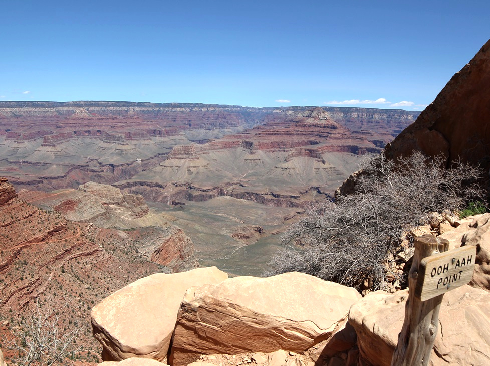
Leaving Gunther at home for a few hours one day, Nancy and I went on a great hike down into the canyon on the South Kaibab Trail to see this view looking across the eastern Grand Canyon. The sign at lower right indicates viewers’ usual reactions.Here we see an intrepid hiker (it’s Nancy) making her way from Ooh Aah Point, beginning the return to the canyon rim on the South Kaibab Trail. This view is looking north.This view, from a point about as far west as we walked on the Rim Trail, is looking east toward the Visitor Center. The zig-zagging line at the bottom of the image is the Bright Angel trail, which Nancy hiked with friends some years ago. It’s an aggressive hike.One more view of the Mather Point overlook: on the morning of April 25, 2023, Nancy and Gunther and I got up early to watch the sunrise at Grand Canyon National Park. The low angle of the dawn’s rays gave the canyon’s features added depth and still more colors that we hadn’t yet seen. This is nearly the same perspective as the fourth photograph in this blog, but compare the coloration and shadows between the two images. The sun has risen on this landscape 2.2 billion times since the Colorado River began carving the canyon. This was just one of those times, but it was still spectacular.
If you’ve been to Grand Canyon National Park, you know this: it’s a must-see park; if you haven’t been, know this: you must see it. The views are simply unmatched, at least in my experience, and the hiking opportunities range from level and paved trails to “park rangers may not be able to come rescue you,” with everything in between.
For such a recent addition to the Earth’s surface (seriously, 6 million years of erosion on this planet is absolutely nothing in the grand scheme of things), the Grand Canyon is an amazing spectacle that really has to be seen in person to get a full appreciation of its beauty. As much as I’ve gone on and on about it, you won’t be prepared when you see it, either.