The Bear River, at 350 miles long, is the country’s longest river that doesn’t eventually reach an ocean – but it is the largest river that flows into the Great Salt Lake of northern Utah. It starts in northeastern Utah, flows into southwestern Wyoming and southeastern Idaho, then makes its way back into Utah and into the Great Salt Lake.
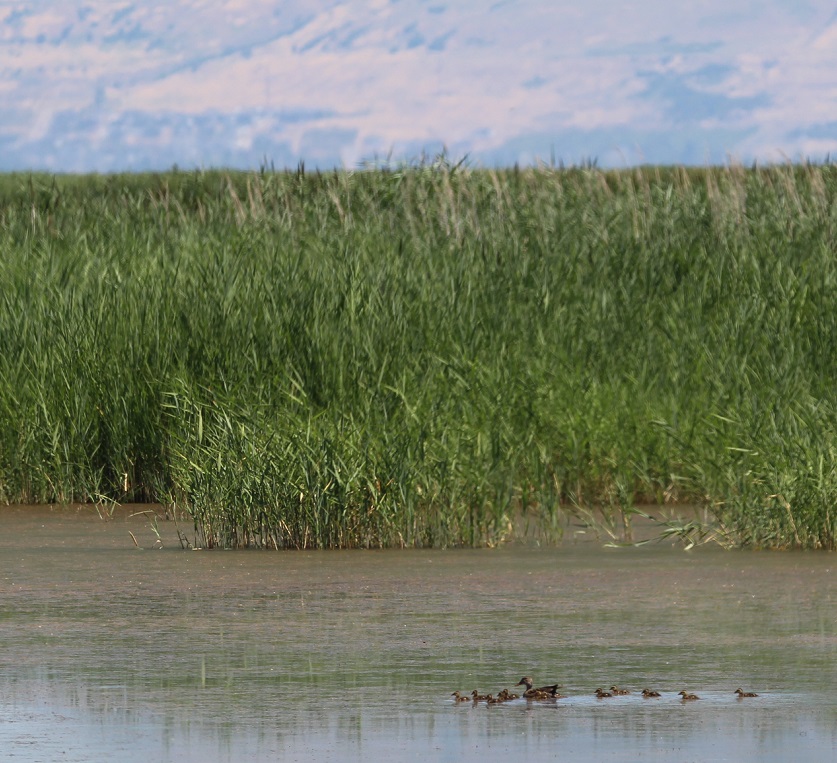
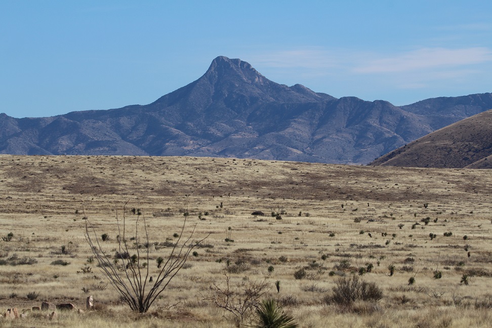
I took this photo looking east from an observation platform along the Bear River, a few miles before it enters the Great Salt Lake. The Wasatch Mountain range, forming the western edge of the Rocky Mountains, is on the horizon; Box Elder Peak (elev. 11,101 feet) and Willard Peak (9,763 feet) are two of the prominent mountains in this part of the Wasatch range. As in many areas of the west, the 2022-2023 snow season was quite robust in the Bear River drainage and provided plenty of water flowing into the lake in mid-July. More on that later, though.
This family of gadwalls (Mareca strepera), a species of duck that, thanks in no small part to the establishement of wildlife refuges, has been growing in numbers since the 1980s, is making its way down the Bear River. Female gadwalls closely resemble female mallard ducks, but their heads and bills are shaped differently. This mom is tending to at least 11 ducklings; gadwalls can lay up to a dozen eggs in one clutch. In the fall months, 500,000 ducks and geese can be found at the refuge during their migration southward. Imagine all of that quackin’ and honkin’!
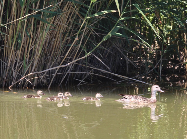
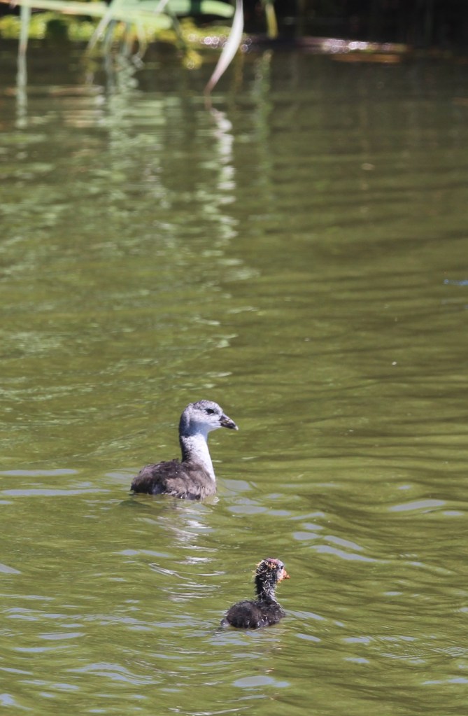
Here’s a closer look at another, and perhaps more reasonably sized, gadwall family. The gadwalls weren’t the only bird species looking after young ones at the Bear River refuge: there were baby waterfowl and shorebirds aplenty.To wit: this western grebe (Aechmophorus occidentalis) and two fledglings (grebelings?). Like many waterfowl, young grebes will often hop on a parent’s back to take a break from paddling. A volunteer at the refuge’s visitor center had suggested that we keep an eye out for the freeloading young grebes, and we were happy to see this family. The plumage of western grebes and that of their closely related cousins, Clark’s grebes, is very dense and their hides were used to make waterproof garments in the 19th century. Thankfully, the popularity of the style dropped and populations of both species, which had declined, soon recovered.More baby waterfowl, this time an American coot (Fulica americana). I had only ever seen black coots before and assumed that the lighter colored ones (like the one at the top of this photo) were females. In fact, both male and female adult coots are black, and so the larger coot here is either mother or father to the cootling but has not yet matured out of its juvenile color pattern. Coots were everywhere in the refuge: I’m going to guess that we saw about 70 kajillion coots that day.
The delta at which the Bear River flows into the Great Salt Lake is where the 74,000-acre Bear River Migratory Bird Refuge was established in 1928. The refuge provides critical breeding and nesting habitat to more than 250 species of birds and other wildlife. Nancy, Gunther and I visited the refuge in mid-July, enjoying a short hike, a 12-mile auto tour, and the company of thousands upon thousands of birds.
We’d seen white-faced ibis (Plegadis chihi) only once before, at St. Vrain State Park in northern Colorado, and that was a flock in flight and so far up in the sky that I thought they were Canada geese until I took a closer look at the photo. There were plenty of these beautiful birds on the ground at Bear River National Wildlife Refuge. They use their distinctive curved bills to dig in the wet dirt around waterways in search of earthworms and other invertebrates. I look forward to getting better pictures of white-faced ibiseses(es) sometime: their purple, green, and bronze plumage is really pretty.
The Bear River Migratory Bird Refuge is located where two of the country’s major migratory flyways, the Pacific and the Central, overlap. Because of its connection to the ecosystem of the Great Salt Lake, the refuge is a critical stopover for migratory birds of all sizes.
Administered by the U.S. Fish & Wildlife Service, the National Wildlife Refuge system includes more than 550 refuges in all 50 states and territories. In all, more than 150 million acres (almost 235,000 square miles, or more than twice the size of Colorado) are protected to support more than 700 bird species and 220 mammal species, along with hundreds of amphibian, reptile, and fish species.
Due to the loss of habitat from population growth, as well as a botulism outbreak, Utah citizens and conservation organizations asked Congress to protect this area, and the national refuge was created in 1928.
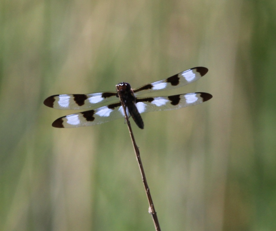
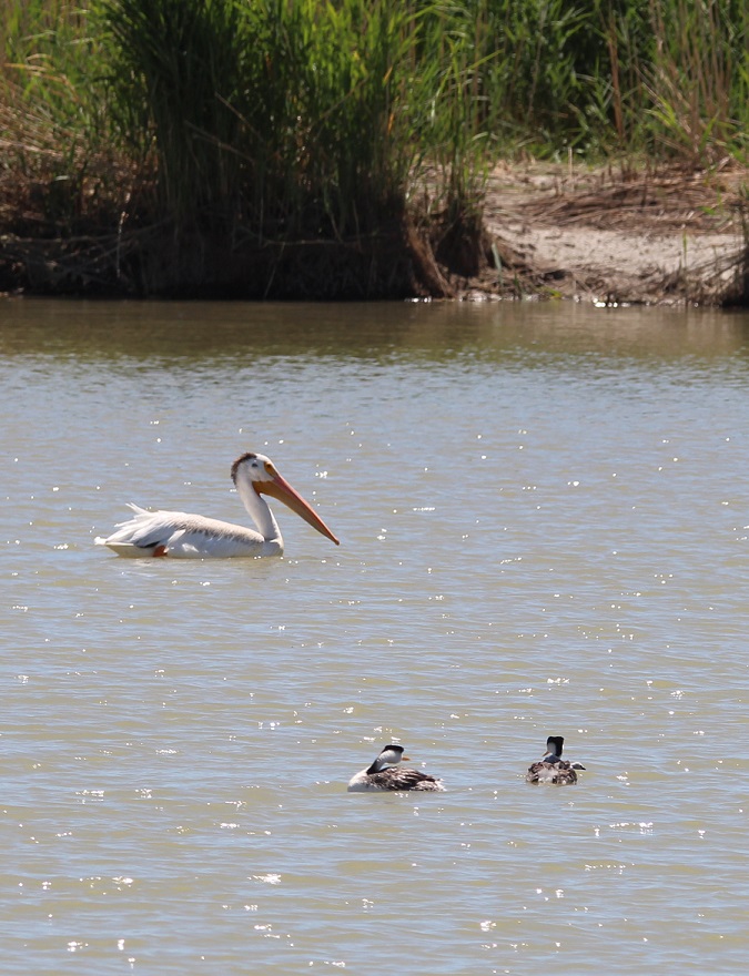
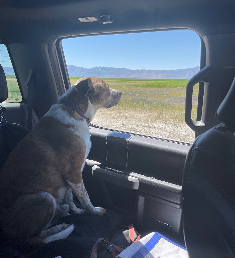
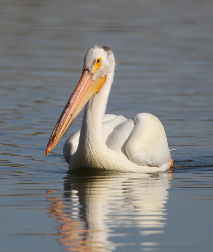
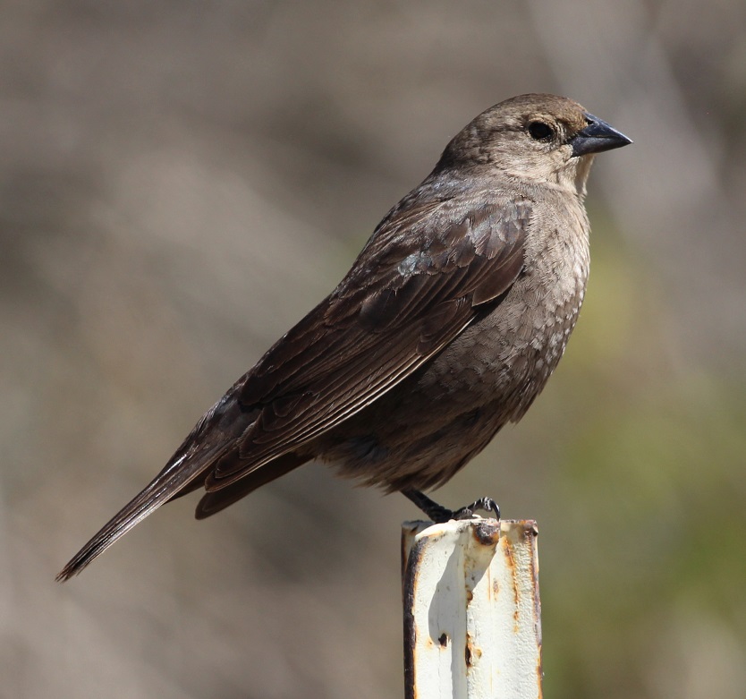
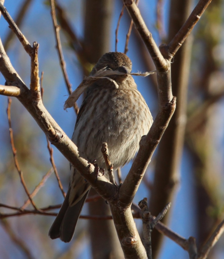
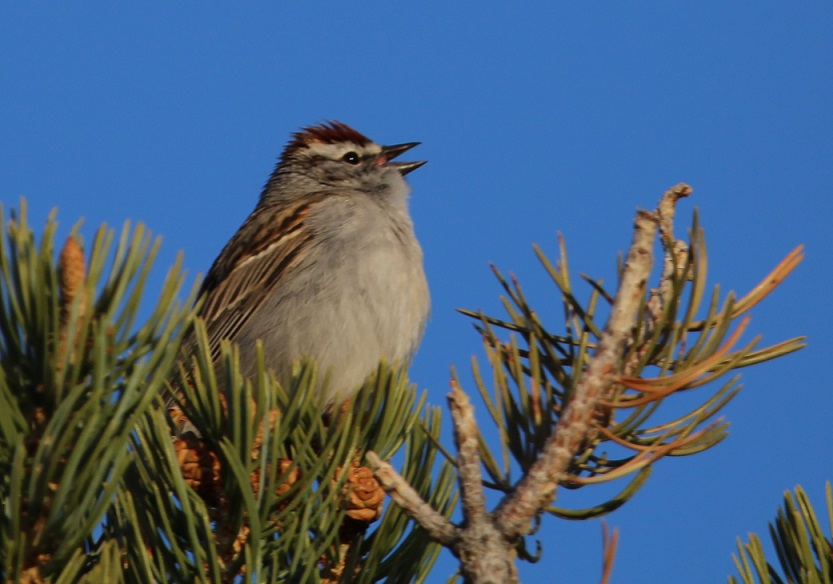
This black-necked stilt (Himantopus mexicanus) was yammering away while on the hunt for something good eat on the shoreline. The refuge is home to 65,000 black-necked stilts in the fall months. This species is closely related to American avocets, and, although it’s rare, the two can create hybridized offspring called “avo-stilts.”Ready for a break from birds? How ’bout a bug? This is a twelve-spotted skimmer (Libellula pulchella), a type of dragonfly. It was resting on a reed in a marsh next to the refuge’s visitor center. This is a very common dragonfly and is found in all 48 of the contiguous states. If you only count 10 spots, that’s okay – they’re also called ten-spotted skimmers. They’re one of the bigger dragonfly species, at up two two inches long and with an even longer wingspan. Insects like this are, of course, a major component of a wildlife ecosystem. Dragonflies eat smaller insects, and they themselves are eaten by birds and reptiles.To wit (again): this house sparrow (Passer domesticus) with a late breakfast on the visitor center’s roof (it looks like it has an unfortunate grasshopper rather than an unfortunate dragonfly in its beak, but you get the idea). The most common birds in the United States – house sparrows, rock pigeons, and European starlings – are all introduced species. None are native to this country, but they did remarkably well for themselves once they got into the wild.Here’s a native sparrow species, the song sparrow (Melospiza melodia). This species is found from Alaska’s Aleutian Islands to the country’s east coast. The coloration of their feathers varies depending on the conditions in the local population’s habitat.The variation in bird species we saw was pretty remarkable. Here are two western grebes pondering an American white pelican (Pelecanus erythrorhynchos), one of the largest birds in North America. We didn’t see many pelicans during our visit, and those we did see were pretty far away. This photo was taken in the delta area of where the Bear River enters the Great Salt Lake.Here’s another big white bird: the snowy egret (Egretta thula). During the breeding season, snowy egrets develop very thin feathers on their necks. These feathers were once highly valued by the fashion industry: in the 1880s, they had a per-ounce value twice that of gold. Naturally, the numbers of snowy egrets dropped precipitously, but conservation efforts, including the establishment of national wildlife refuges, helped restore the population. Check out those yellow feet! This egret was kickin’ it with a small herd of cattle, probably looking for insects and other invertebrates disturbed by the bovines. Back to bugs, briefly. There are about 3,000 known species of dragonflies in the world, and we saw three of them at the wildlife refuge. This one is a blue dasher (Pachydiplax longipennis), and like other dragonflies, is capable of eating hundreds of smaller insects every day.One more dragonfly; this is a variegated meadowhawk (Sympetrum corruptum). This species, native to North America, has been found migrating south to Honduras and as far as eastern Asia.Of the 256 photos I took at the refuge (I’m not kidding), this one is my favorite and it might be my favorite that I’ve taken this year. It’s an American avocet (Recurvirostra americana), and I took this picture after crawling slowly and steathily through a half-mile of stinking wet marshland in an attempt to unobtrusively approach this bird. I’m just kidding iwth you right now: I took this photo from the passenger seat of the Goddard’s six-wheeled towing unit while the avocet was walking down the side of the road. Avocets use their gently curved bill to sweep through shallow water in search of invertebrates. The plumage on their head and neck darkens to this beautiful russet during the summer, and then retreats to white and gray during the winter. They grow to about 18 inches tall. What an elegant bird.Here’s another photo I took from the passenger seat of our pickup. Gunther has enjoyed several auto tours with us this year, and we were happy to have him along at the wildlife refuge. He’s taken a special interest in seeing horses from the back seat.
About the water issue I alluded to at the beginning of this post: while the Bear River seemed to be flowing at or near the capacity of its banks thanks to a great snow season in the Rocky Mountains, the Great Salt Lake is undergoing an historic multi-decade drought that has shrunk the lake to just 37 percent of its former volume. It’s something that’s happening all over the western United States: higher temperatures coupled with decreased annual precipitation levels, exacerbated by growing populations of people, are creating smaller river flows and diminishing bodies of water. What’s happening at the Great Salt Lake specifically is a crisis that, in my mind, isn’t getting nearly enough attention: in addition to the critical wildlife habitat that would be lost, a dry Great Salt Lake bed would create a huge volume of toxic dust directly adjacent to Salt Lake City. It’s a metropolitan area of 1.3 million people, and one that is growing quickly.
The consequences of losing the Great Salt Lake are difficult to imagine, and I don’t even want to consider what life around Salt Lake City would be like. Conservation efforts, meant to reduce the amount of water taken (mostly for agricultural purposes) from the Great Salt Lake’s three tributaries prior to entering the lake, are underway. The Church of Jesus Christ of Latter-day Saints, one of the west’s biggest land- and water-rights holders, has taken the unprecedented step of donating a sizable amount of its water to the lake, and is encouraging its adherents to conserve as much water as they can, but it may be a case of “too little, too late.” The 20,000 acre-feet of water donated by the Mormons, while a significant amount on its own, is enough to replace only about 2 percent of the lake’s lost volume.
We saw 19 different bird species in about four hours while at the refuge. All of those species, and all of the other birds and other animals at the refuge, are dependent on healthy waterways to breed and raise their young – in other words, to continue as a species. I hope that happens, for all of them.
From scenic Tennessee, the Goddard hurtled northward in the summer of 2022 – destination: Michigan, to visit Nancy’s sisters and their families. On the way, we stopped to visit a couple of national parks in Kentucky and Indiana. We’d visited Mammoth Cave, located in central-west Kentucky, some years ago (Nancy’s way into caves – like, way), but it was time for a return visit. We made not one, but two trips underground to visit different parts of the cave; on another day, Gunther also joined us for a fun hike above the surface of the earth.
Mammoth Cave’s story begins, as do so many of the tales recounted in this blog, 350 million years ago when this part of present-day Kentucky (and most of the rest of the current United States) was covered by a vast inland sea. Corals and shell-bearing organisms produced calcium carbonate (CaCO3), which precipitated out of the seawater to fall on the seabed below. There were a lot of corals and shellfish: the CaCO3 their bodies created gradually accumulated to develop a 450-feet-deep layer of sedimentary limestone at the bottom of the sea.
In the ensuing hundreds of millions of years, the sea retreated and the limestone was covered by more layers of shale and sandstone. Mammoth Cave is the world’s biggest example of a solution cave, meaning that it was created when rainwater percolated downward and picked up naturally occurring carbon dioxide in the air and soil to became very weakly acidic. Ten to 15 million years ago, the percolation dissolved enough of the limestone to allow greater volumes of water to flow through the crevices. The force of the Green River took it from there, cutting through the highly erosional limestone using both water pressure as well as a mild acidity present in the river. The passages of the cave closest to the surface are the youngest in the system: only about 2 million years old. While the protective layer of harder shale and sandstone is keeping the brakes on vertical erosion from rainwater, the Green River is still creating more Mammoth Cave under the earth today.
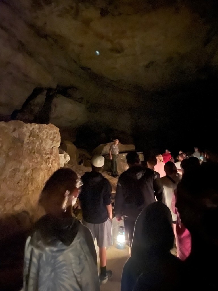
Our guide, National Park Service Ranger Matthew, a retired schoolteacher, welcomes the Star Chamber Tour group to the Historic Entrance of Mammoth Cave. Matthew is a retired schoolteacher. The tour, which started at 6 PM, allowed us to visit the cave as those who entered the cave a hundred years ago did: with oil lanterns. The Star Chamber tour is two miles long and lasted 2 1/2 hours; it was nearly full dark when we emerged from the cave. Ranger Quentin is behind the shrub in the center of the photograph; we talked with him a bit during the tour and he shared that he’d just been informed that he’d been named a full-time NPS ranger. As anyone who has spent time in national parks can imagine, it’s a very competitive position; Quentin is a native of the Cave City area, so it had to be especially rewarding.
Native Americans lived in the area around Mammoth Cave for thousands of years, exploring the cave and using it for mineral extraction. They entered the cave through what is now known as the Historic Entrance, and explored at least 14 miles of the system using only the flame from burning torches for light. Evidence shows that Native Americans stopped using the cave about 2,000 years ago, and the caverns were unknown for more than 200 years.
This is the Historic Entrance to the cave, accessed by a long stairway (the stairs seen at the right of the image above). There are about 30 entrances to the cave system, some of which are just small holes barely large enough to squeeze through.
Local history holds that the first European-American entered the cave in the late 1790s. A young boy named John Houchins was hunting black bear (no longer found in the area) and inadvertently came across the huge hole in the ground that is now the Historic Entrance.
During the War of 1812, the cave’s … significant … deposits of guano (there are 13 known bat species in the park, but not all use the cave) served our nation as a source of saltpeter, a component of gunpowder. Some of the wooden assets used in the guano mining operations are still to be observed in the cave, thanks to its cool and humid environment (54 degrees and 87 percent humidity, all day, every day, all the year round).
The site became a local tourist attraction but, because of the area’s remoteness, didn’t see much out-of-state visitors for many decades until the automobile was developed and popularized. The property was privately owned by different interests through the years, all of which conducted tours of the underground passages, until concern about preserving the caverns’ natural resources resulted in Mammoth Cave National Park being established on July 1, 1941. It is the country’s 26th national park. In its first year as a national park, Mammoth Cave saw about 58,000 visitors; we were two of about 663,000 people to visit the park in 2022.
True to its name, Mammoth Cave is pretty big: in fact, it’s the longest cave system in the world and fully twice as long as the next-longest system. Mammoth Cave is currently mapped to include more than 400 miles of caverns (the entire state of Colorado is 380 miles wide), and the scientists believe that as many as 600 miles of caverns remain to be discovered and mapped. The system has been likened to a bowl of spaghetti, with passages intersecting and moving up and down multiple levels .
Understandably so, flashlights and flash photography were forbidden on the cave tours so the photos I was able to take are terrible because the only light available came from lanterns (on the Star Chamber Tour) or electric lights along the cave passages (on the River Styx Tour). However, some of the photos give a sense of scale to the caverns. Much of the present-day caverns are completely dry – the river water that carved them disappeared quickly into deeper caverns many years ago – so there’s no dripping water to create stalagmites and stalactites, along with other formations familiar to spelunkers. To be honest, although there are some beautiful formations to enjoy, for me most of Mammoth’s impressiveness – and there is plenty of that – comes from its sheer size. Mammoth Cave is big, and it’s dark. I remember a ranger’s tale from the first time we visited the national park: in the mid-1930s, before the park was managed by the NPS, the mummified body of a Native American (who’d lived before Columbus reached the New World and was killed when he was struck by a large falling rock) was discovered on a ledge in one of the caverns. By that time, hundreds of guided tours had passed by the body and all of the people – numbering in the thousands, at least – in all of the tours were unaware that they were passing by the mummy, which was only a few feet above their heads. It was just too big, and too dark, in Mammoth Cave to know about the mummy until someone happened to come across it.
The pandemic limited the number of tours available; some of the tours that Nancy and I went on during our first visit weren’t available at the time of our visit in July (mostly because of a shortage of National Park Service rangers trained to lead the tours). However, we enjoyed the Star Chamber Lanternlight Tour one evening, as well as the daytime River Styx Tour on another day.
The cave’s corridors vary greatly in size: some passages require visitors to walk sideways in order to pass through, and other caverns are wide enough to accommodate a Boeing 747 jet (I didn’t see any aircraft on either tour, but it was pretty dark).
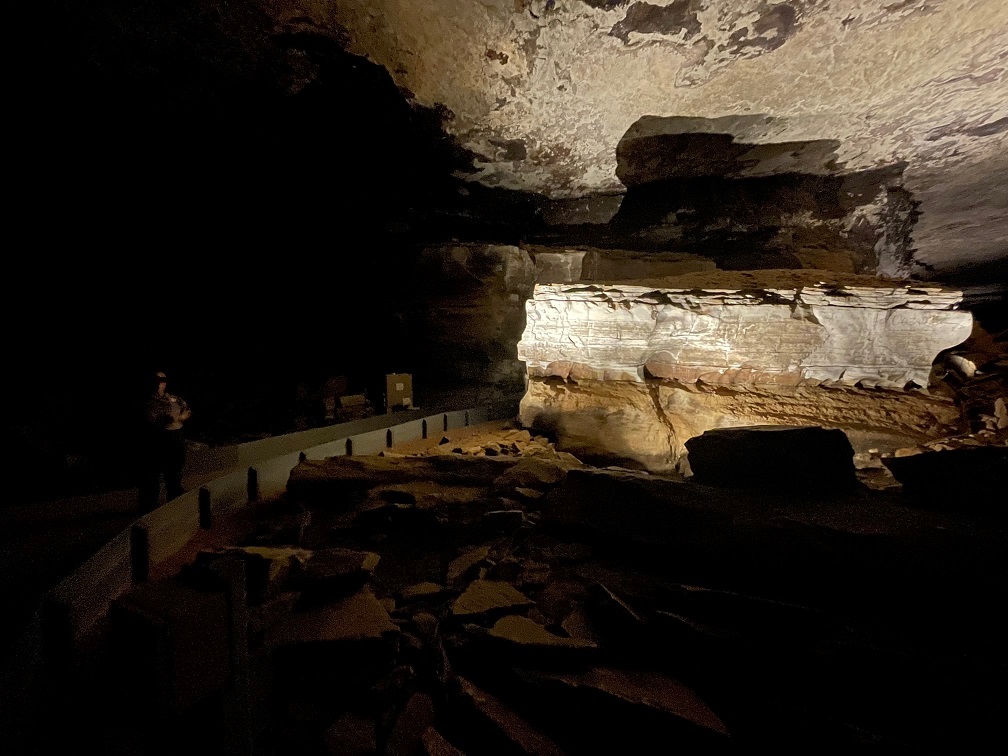
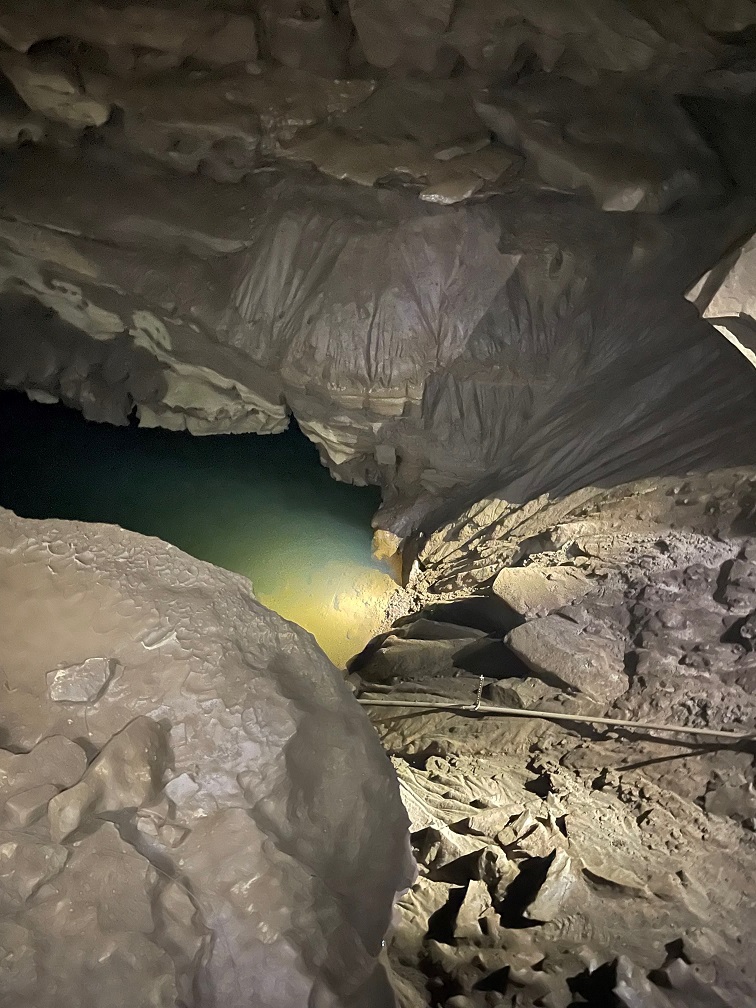
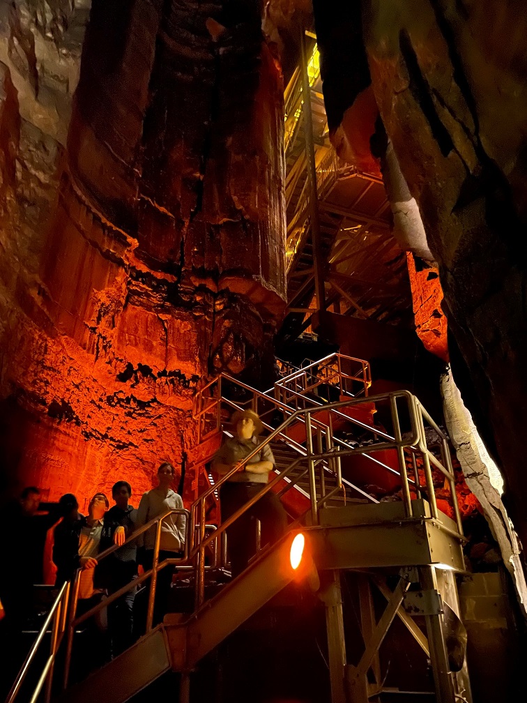
We saw this formation, called the Giant’s Coffin, on both of our tours (which shared a bit of the same trail). Located 175 feet below the surface, the Giant’s Coffin is a limestone nugget measuring nearly 50 feet long and 20 feet tall, and weighing a thousand tons. The rock separated from the limestone wall behind it sometime in the distant past; imagine the sound it made when it fell. Our NPS ranger guide is in the shadows at the left of the photo; if I remember right, she’s standing perhaps 50 feet in front of the Giant’s Coffin.At one point on the Star Chamber Tour, Ranger Matthew asked us to place our oil lanterns in a row on the cave floor. He and Ranger Quentin then extinguished all of the lamps and used a flashlight to guide their way behind a rock wall, leaving us in total darkness (he’d mentioned they’d do this beforehand; they didn’t just sneak off and leave us). If you’ve never been in a completely darkened cave, you’ve never known true darkness: the absence of all light. Even being outside on a moonless night, well removed from city lights, isn’t the same because there’s still starlight to provide some illumination, however feeble. It’s a common occurrence on cave tours, this extinguishing of all artificial light, but it never fails to strike some primeval chord – to not be able to see your hand in an inch in front of your face, let alone across the room. It also gives one a better appreciation for those early explorers: modern spelunkers carry all sorts of redundant sources of light – there are only so many torches or lanterns one can carry.This picture is from the River Styx tour, which was illuminated by electric lighting for most of the 2 1/2-mile trail. The tour includes a visit to the River Styx, an underground tributary of the Green River, but flooding in the cave in 2010 destroyed the electrical system along that part of the tour. We needed battery-powered lanterns to continue. (Incidentally, as of this writing in August 2023, the River Styx tour isn’t being offered – I wonder if the electrical system is being repaired.) Notice the scallop-shaped carvings in the rock ceiling above: those indicate the direction and velocity of the flow of water eroding the rock. Larger scalloped features (a meter or more wide) mean that the water was moving only a few centimeters per second, and smaller scallops indicate that the water was flowing in meters per second.This is a pool known as the Dead Sea, created by the Green River. It’s about 15 feet below the point at which this picture was taken. Artificial lighting next to the river shows some details of the water erosion. The occasional blind cave fish or blind crayfish can be observed in these waters; alas, they were not to be observed on this occasion.And here is the River Styx, which looks a lot like the previous photo of the Dead Sea. Bur remember, friends, that the River Styx is but a tributary of the Dead Sea’s Green River.Here was another highlight of the River Styx Tour: seeing the incredible Mammoth Dome. Known in spelunking terms as a “vertical shaft,” Mammoth Dome was created when water followed the law of gravity to flow straight down vertical crevices in the limestone. The erosional activity results in shafts that, at Mammoth Cave, measure 30 feet or more. In Mammoth Dome’s case, that resulted in a vertical shaft measuring 190 feet in height. An impressive metal staircase provided a lot of viewpoints to see the dome (there’s still a lot of climbing to do; see the top of the staircase at the top of the photo).
River Styx Spring Trail
While there are a number of different tours available for anyone wanting to explore the bowels of the earth at Mammoth Cave National Park, it also features more than 80 miles of above-ground trails. Gunther joined Nancy and me for a hike on the River Styx Spring trail, which provided for some great views of the Kentucky countryside.
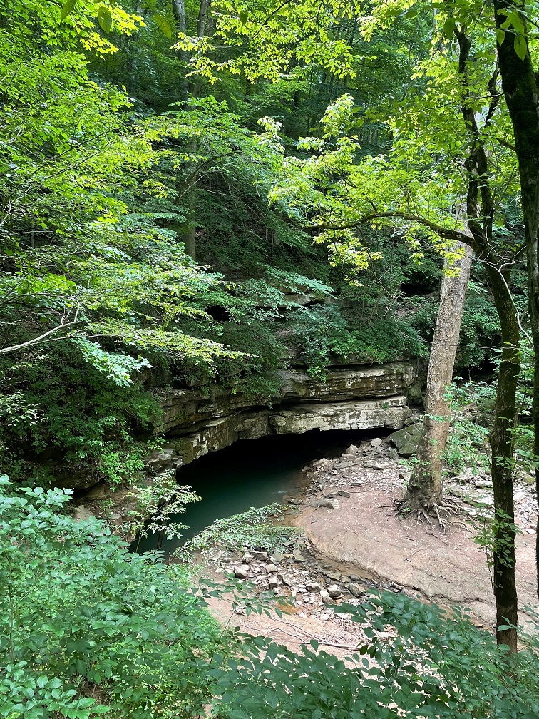
Because we spent most of our lives in Colorado, neither Nancy nor I are familiar with vistas like this: hardwood forests as far as the eye can see. Mammoth Cave National Park currently encompasses 53,000 acres, or about 80 square miles; while it’s justifiably most famous for its subterranean caverns, there are plenty of opportunities for above-ground adventures.We encountered this whitetail fawn near the trailhead of the River Styx Spring trail. Its mom was less than 10 feet away. It must be pretty used to seeing humans; I don’t think I’ve knowingly ever been this close to a young fawn before. The speckled pattern on a very young deer’s sides act as a kind of camouflage, helping it to blend in with the sun-dappled undergrowth in forests. I would think that fawns would also be predominantly grass-green instead of brown, but I suppose evolution knows what it’s doing.The River Styx Spring Trail passes by a historic cemetery that is the final resting place of Stephen Bishop, one of the first non-Native-American explorers of the cave system. Bishop’s story is very interesting: in 1839, the Mammoth Cave estate, along with several Black slaves including Bishop, were sold to Dr. John Croghan for the amount of $10,000 (about $275,000 today). Croghan began to explore making improvements to the property’s tourism assets, like the hotel, and Bishop began to explore the underground caverns. A gifted spelunker and popular guide, Bishop also named many features within the cave – including the River Styx. In 1844, he published a detailed map of the cave system; the map would remain the primary guide to the cave for 40 years. The map contained about 10 miles of passages within Mammoth Cave, half of which Bishop discovered himself. Croghan envisioned using part of the interior of the cave as a tuberculosis treatment facility – some of the stone housing built for tuberculosis patients in 1841 is still standing along present-day tours of the cave – thinking that the cave’s environment would provide helpful results, but the treatment failed. In fact, all 10 of the tuberculosis patients either died in the cave or later after they exited the cavern. Further, the widespread disease would claim the lives of both Croghan and Bishop: Croghan died in 1849, and had stipulated in his will that Bishop would be declared a free man seven years after Croghan’s death. Bishop did enjoy a few months of freedom beginning in 1856, but tuberculosis claimed his life in the summer of 1857. He was buried on the Mammoth Cave grounds but his grave remained marked only by a cedar tree until 1881, when a second-hand tombstone (it was originally intended for a Civil War veteran’s grave but the family never claimed it – explaining the appearance of a sword and flag on the headstone) was inscribed and placed at Bishop’s gravesite. The date of his death is incorrect on the headstone.Look at this rock Gunther found on the hike! Look at it! In addition to seemingly endless hardwood forest vistas, neither Nancy nor me nor Gunther were used to the high temperatures combined with the high humidity of central Kentucky in July. This part of central Kentucky gets about 50 inches of rain each year.Here is the terminus of the River Styx Spring hike: a view of the water feature we’d seen only underground. Presumably any fish or crayfish in this part of the river have the gift of sight.
A couple of birds
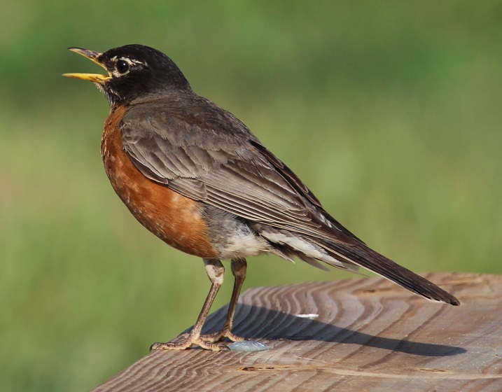
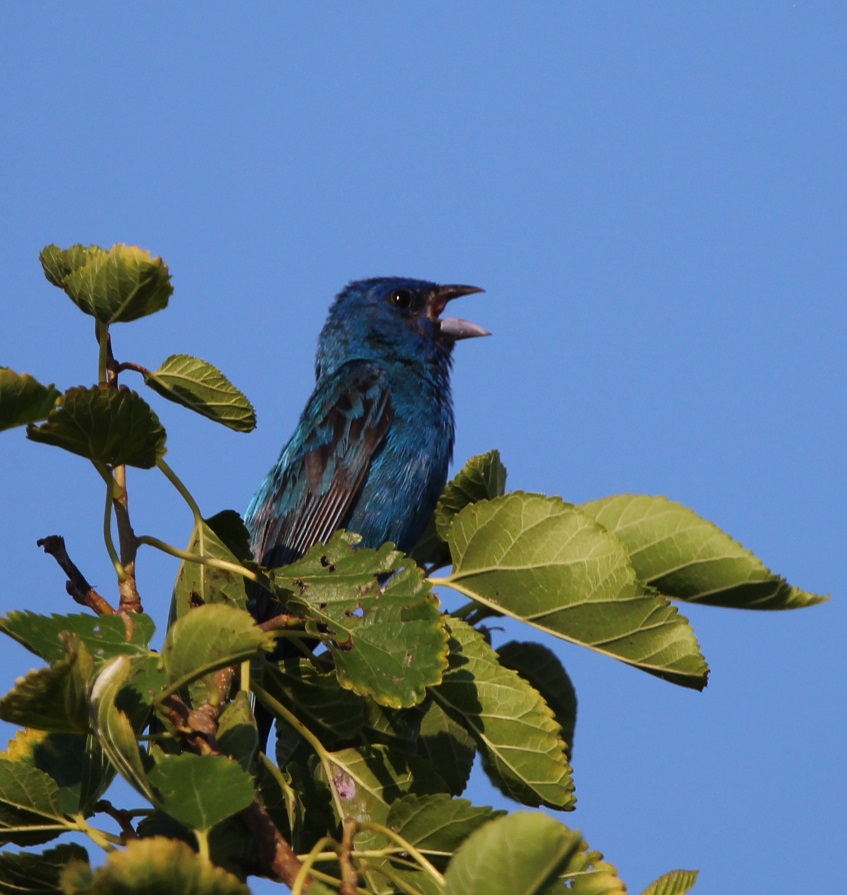
I’ll close with a couple of bird photos from our campground in Cave City, which is a little more than 10 miles from the Mammoth Cave National Park visitor center. This is, of course, an American robin (Turdus migratorius) that lit upon one of our campground’s picnic tables. They’re common birds but always fun to watch. They’re found throughout the United States but breed in Canada.Here was a new bird to me: an indigo bunting (Passerina cyanea). They’re found in the eastern United States and the southern part of the country. The scientists discovered that indigo buntings, which, like many other species migrate at night, and navigate using the stars. The experiment involved placing some of the birds in a planetarium. The birds adjusted their orientation in the room as the projected stars above changed position. Their remarkable blue color is due to microscopic structures in their feathers that reflect and refract blue light – very similarly to why the sky above the bunting looks blue.
There are a number of NPS sites that prominently feature caves including a couple, perhaps improbably, in South Dakota, which we visited a number of years ago (did I mention that Nancy likes caves?) However, none are bigger than Mammoth Cave in Kentucky, and, thanks to the Green River, it’s getting bigger every day.
Thank goodness we were done with caves for the year.*
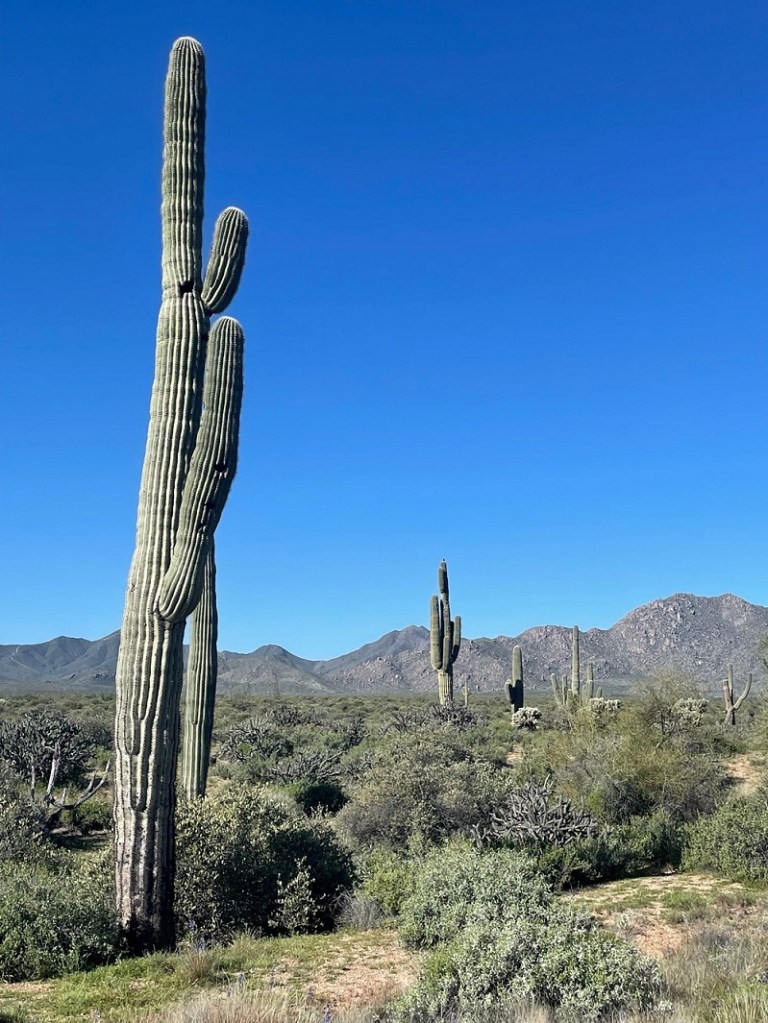
McDowell Mountain Regional Park is one of 14 parks in Maricopa County that have been preserved as open spaces and protected against private development – an important consideration for the Phoenix metropolitan area, one of the fastest-growing parts of the country. Some of the regional parks offer camping, and the Goddard spent two weeks in March in the shadow of McDowell Mountain, surrounded by saguaros and sparrows – along with a surprising diversity of other plants and birds.
Here’s a look at some of the Sonoran Desert birds we saw during that two-week stay. I was expecting to see at least some birds, but I wasn’t expecting to see some of the species that we actually did, nor the quantities of birds and different bird species that we saw. Keep in mind that most of these pictures were taken very close to our campsite – some were taken from our fifth-wheel’s steps – and all were taken no more than a quarter mile away from the Goddard.
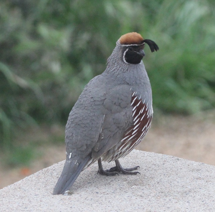
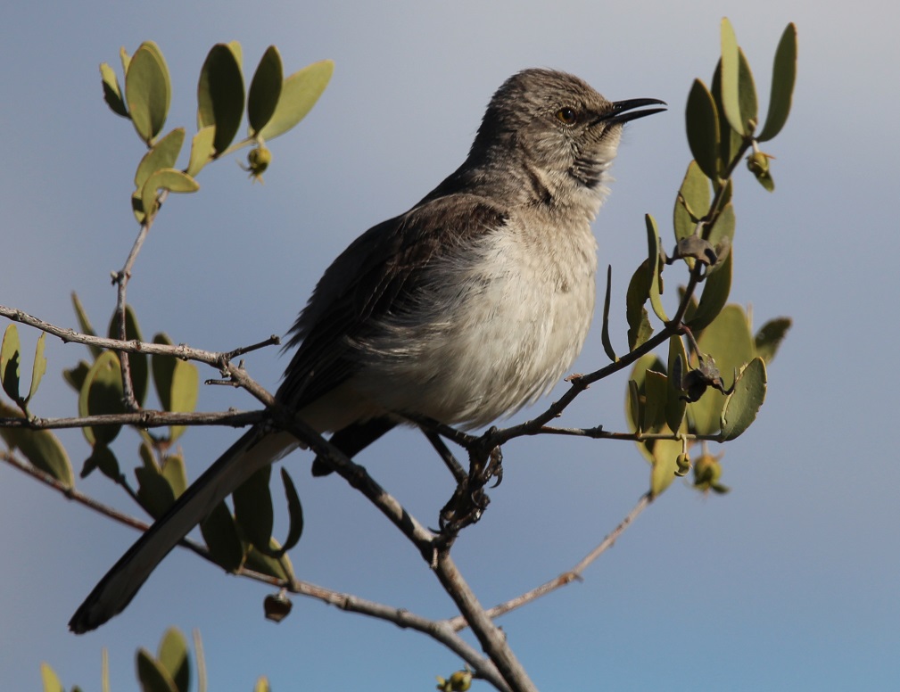
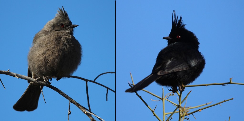
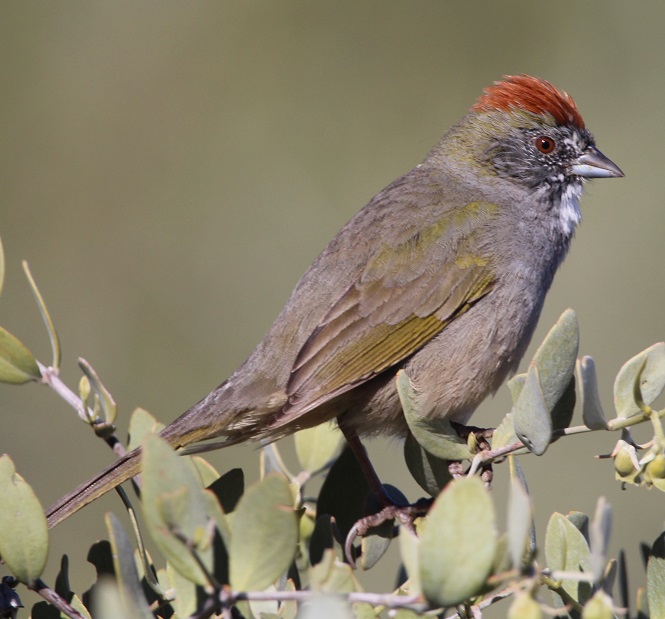
McDowell Mountain Regional Park, situated east of the city of Phoenix, protects just under 22,000 acres (about 34 square miles) of the Sonoran Desert for public use. The park is at the northern reaches of the desert, which itself contains more than 100,000 square miles stretching from southern Arizona down into northwestern Mexico and Baja California. There are plenty of saguaros and other cacti species in the park, along with a tremendous variety of other succulents, shrubs, wildflowers, and grasses. I’m working on a different blog posting that highlights the flowers that were in bloom during our stay in the park – I was really surprised at the variety.This is a female Gila woodpecker (Malanerpes uropygialis), one of the more characteristic birds of the Sonoran desert. Gila (pr. HEE-la) woodpeckers make their nests, containing 3-5 eggs, high up in saguaros, as seen here, and trees. In the United States, these birds are found only the extreme southern areas of the southwest. Male Gila woodpeckers look identical to the female, with the exception of a bright red cap on the top of their head.We’d seen Gambel’s quail (Callipepla gambelii) before, including at a campground in Deming, New Mexico. However, we’d never been close enough to get some decent photos. I took this while standing on the steps of the Goddard and this male quail was standing on our campsite’s concrete picnic table perhaps a dozen feet away. We saw quite a few of these beautiful birds during our stay at the park, and heard a lot more once we learned what their distinctive calls sound like (play the soundfile below, if you dare). Gambel’s quail nests contain between 10-20 eggs. The birds, native to the extreme southwestern United States and introduced in western New Mexico, are usually found on the ground, although we did see a few on top of saguaros (and our picnic table). Gambel’s quail are named after ornithologist and naturalist William Gambel (1823–1849), who at the age of 18 traveled overland to California. He was the first botanist to collect species in Santa Fe, New Mexico, as well as parts of California. A genus of southwestern U.S. lizards is also named in his honor.Nancy took this photo of a black-throated sparrow (Amphispiza bilineata) while perched in her camp chair right next to the Goddard; the sparrow was perched atop a buckhorn cholla that’s about to bloom. Both sexes of this species have the same plumage. These birds, also known as desert sparrows, are remarkably well-adapted to the hot and arid conditions of the Sonoran; during the heat of summer, they derive all the moisture they need from eating insects and seeds. Which is good: at the time of this late-afternoon writing in late July 2023 (we’re currently in southern Idaho), it’s 110 degrees at McDowell Mountain Regional Park. There are 26 species of sparrows in the United States, and most of them are generally brown. The black-throated sparrow is easy to identify, though. (Photo credit: Nancy Jardee)Although I’d read in the park’s literature that this species could be found in the area, it was still a pleasant surprise to see a loggerhead shrike (Lanius ludovicianus) while on a short hike around the campground. I’d never knowingly seen one before, but I’d read quite a lot about them: they feed mostly on insects but will also hunt for mice, lizards, and other small birds when times are tough. Additionally, although this one looks fairly innocuous (that savage hook at the end of his beak notwithstanding), shrikes impale their food on barbed wire or thorns as a means of storage, earning them the nickname “butcher birds.” This curve-billed thrasher (Toxostoma curvirostra) is perched atop a saguaro. I never did quite get used to seeing birds on top of cactus thorns, but I guess they don’t have a problem with it. When they’re not perched on a cactus, curve-billed thrashers spend a lot of time on the ground looking for insects. The look on these thrashers’ faces always reminds me of Sam the Eagle from “The Muppet Show.” I first saw one of these birds at the Tucson Botanical Garden.Since first seeing a northern mockingbird (Mimus polyglottos) near Tulsa, Oklahoma, in 2022, we’ve managed to see plenty of them all over the country. I wonder if it is due to the Baader-Meinhof Phenomenon, like when you learn a new word and then see it a lot in the next few days. Anyway, they’re fun to see and quite enjoyable to listen to – some are capable of learning 200 songs throughout their lives.While I wasn’t particularly surprised to see a northern mockingbird, I was surprised to see this northern cardinal (Cardinalis cardinalis) in the Sonoran Desert. It urns out that the species, while limited mostly to the eastern United States and Mexico, does have an established habitat in southern Arizona. Even though this guy was perhaps 75 yards away, he definitely caught my eye (I also heard his call to let me know in which direction to look). Only a few female bird species sing, and the northern cardinal is one of those species. Interestingly, northern cardinals don’t migrate – they stay in one location all year long.This is a composite image of a female (left) and a male (right) phainopepla (Phainopepla nitens), which are found in the southwestern United States and Mexico. We’ve seen them in Silver City, New Mexico, quite a bit. Absolutely beautiful birds. Their Latin name means “shining robe.” Phainopepla (pr. fay-no-PEP-luh) have evolved to eat mistletoe berries, which are low in nutrients but the birds can eat more than a thousand of them in a day. They can mimic the calls of other birds, including the Gambel’s quail. This is one of the species that has red eyes – there are several theories for that, but one I like is that there is a high concentration of blood vessels in their eyes to help with blood circulation. This pair liked to hang out on the same tree at the same time every morning – very dependable, which is a nice attribute for a bird. Here’s a first-for-me bird: the green-tailed towhee (Pipilo chlorurus). The species, which is only found in the western part of the country, migrates to the northern states for breeding but lives year-round in southern and central Arizona. They are very secretive and can be difficult to see. This guy was hanging out near our picnic table as I got back from a birding walk; I should have just stayed home.A small flock of white-crowned sparrows (Zonotrichia leucophrys) took up residence in a thorny thicket of mesquite along one of the hiking trails near our campground. This species, one of the few sparrows that’s relatively easy to identify, overwinters in the southern United States and is found seasonally all over the country, as well as Canada and Mexico – Alaskan white-crowned sparrows fly 2,600 miles to spend their winters in sunny southern California. One white-crowned sparrow was recorded flying 300 miles – about the distance between Colorado’s northern and southern borders – in a single night.One more sparrow, which I am 98% sure is a Lincoln’s sparrow (Melospiza lincolnii). They are found at least seasonally all over North America and Mexico, with the exception of the southeastern part of the country and extreme northern Canada. This species is not named after the luxury division of Fort Motor Company, as one might think, but rather after Thomas Lincoln, a chum of noted birder John James Audubon. Of the 26 species of sparrows, I can identify only three (house, black-throated, and white-crowned) conclusively. Anyway, almost 12 percent of the North American sparrows are on this blog posting.I’ll close with the cactus wren (Campylorhynchus brunneicapillus), one of the more characteristic birds of the American southwest. In fact, it’s the state bird of Arizona. It’s a noisy little guy, with a call that has been likened to someone trying, and failing, to start a car (reference soundfile below). They are one of the few bird species that roosts in nests throughout the year instead of only during the nesting season.
Nancy and I sort of started birdwatching before we sold our house two years ago, but we’re pretty full-bore into it now. We’re very fortunate to live the way we do, with opportunities to enjoy the tremendous variety of birds in different parts of the country.
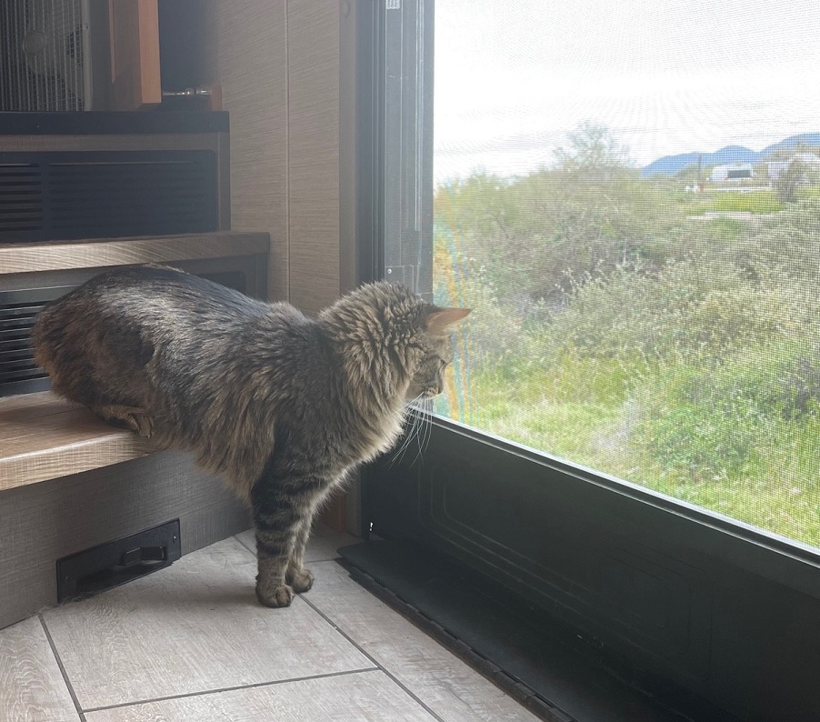
We’re not the most expert birdwatchers on the Goddard, though. Rusty shows us how it’s done:
We took the Goddard on an east-southeast course in the early summer of 2022 in order to get to our destination of Tishomingo, Mississippi, by late June for some warranty repair work on our home. Our travels took us through the states of Oklahoma and Arkansas, in which neither of us had previously spent much time .
In addition to seeing some new sites of interest, like the Philbrook Museum of Art in Tulsa, we also saw wildlife that was new to us since we were in an unfamiliar part of the country. Depending on where you live, these might be common in your area, but here’s a recap of the birds, new to us, we saw in Oklahoma and Arkansas while on our way to Tishomingo.
Northern mockingbird
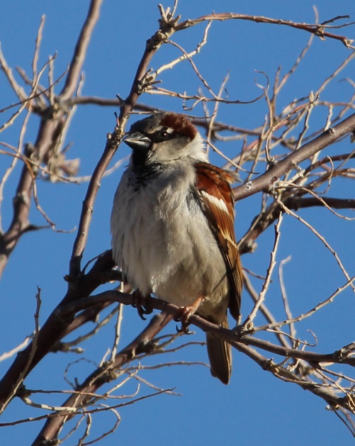
We’ve seen many of these birds in the last 12 months, including in the western United States, but the first place we saw a northern mockingbird was about 20 miles west of Tulsa, Oklahoma. This one’s perched on a piece of playground equipment in the campground at which we were staying. Northern mockingbirds, as their Latin name Mimus polyglottos implies, are masters of mimicking the calls of other birds and even other animals and machinery. When we were camped in northern Tennessee later in the summer, a particular mockingbird perched in the campground went through a routine of perhaps 20 different calls every morning. Northern mockingbirds are noted for their intelligence, and are known to be able to recognize different humans. These are the state birds of five states: Arkansas, Florida, Mississippi, Tennessee, and Texas.
I recently finished reading Harper Lee’s novel “To Kill a Mockingbird,” in which a character notes that it’s wrong to kill these birds because “…. they don’t do one thing for us but make music for us to enjoy. They don’t eat up people’s gardens, don’t nest in corncribs, they don’t do one thing but sing their hearts out for us.” They’ve become one of my favorite birds to see and listen to, but they’re (understandably) difficult to identify by their calls alone.
In this same campground, which featured a very nice walking trail along the Arkansas River, we saw two kinds of gulls, great egrets, great blue herons, Baltimore orioles, a northern cardinal, and an indigo bunting. Water makes a big difference when it comes to attracting wildlife.
Northern cardinal
This is not the best photo of this bright species that I’ve taken, but I’m including it because it was the first northern cardinal (Cardinalis cardinalis) I photographed (we’d seen another at the same Tulsa-area campground as above, but I didn’t get a photo). This guy (unlike northern mockingbirds, in which both genders look alike, there’s a clear difference in cardinals) was hanging out in the gardens at the Philbrook Museum of Art in Tulsa. Like the mockingbird, we’ve since seen this species in other places around the country, including in Grand Rapids, Michigan, and (improbably, I thought at the time) atop a saguaro cactus outside of Flagstaff, Arizona. Northern cardinals are very common in the eastern United States as well as a large swath of Texas and parts of Arizona. They do tend to stick out, even in heavy foliage, and they’re always a pleasure to see.
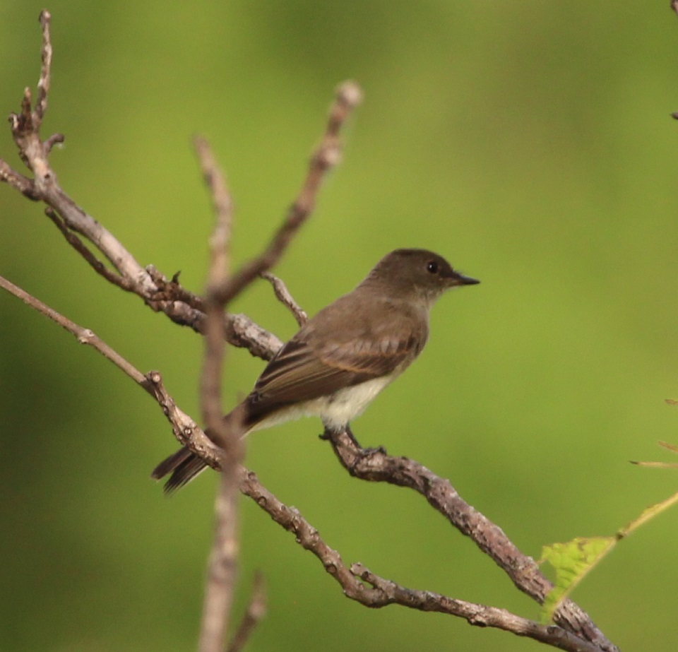
Eastern phoebe
Because we both grew up in Colorado and lived there most of our lives, anytime we see a bird with “eastern” in its name it’s likely new to us. Such is the case with this eastern phoebe (Sayornis phoebe), which is commonly found in the eastern part of the country and especially the south. This little bird, too, was perched on a tree at the Philbrook Museum of Art the evening we were there – it has a bright, very pleasant chirp of a call.
This is one of about 400 species in a group of birds called tyrant flycatchers, the largest group of birds in the world. They’re known for being rather plain-colored like this eastern phoebe [with some notable exceptions, like the scissor-tailed flycatcher (see below) and the vermillion flycatcher, which we saw in early 2023 in Tucson, Arizona]. Flycatchers subsist largely on airborne insects, like their name implies.
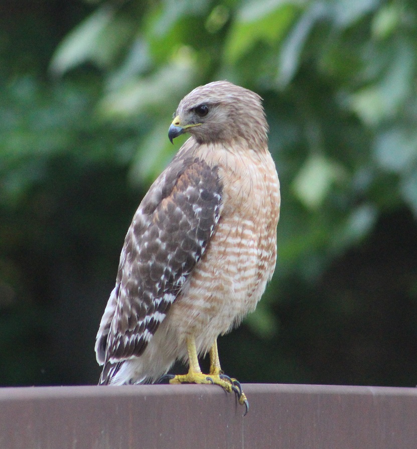
Red-shouldered hawk
This is the same bird that I wrote about in the blog posting about our visit to the gardens at the Philbrook Museum of Art, but I wanted to post this alternate photo because this red-shouldered hawk (Buteo lineatus) gave us plenty of opportunity to admire it while it perched on a bridge railing (until some ne’er-do-well kids came tramping along and scared it off, but whatever). Although there’s a small population in coastal California, this is an eastern United States raptor; Tulsa, in eastern Oklahoma, is on the very western edge of their habitat. They’re a little smaller than the red-tailed hawks that are common in the western United States. This species prefers the cover of heavily treed areas (which describes the gardens at Philbrook Museum of Art quite well). Up until around 1900, these birds were among the most numerous raptors in the United States, but deforestation and, until it was banned, DDT contributed to a marked decline in their population.
These last three birds, all seen in the same 25-acre space, give you an idea of the variety of species that can be enjoyed at botanic gardens – they’re great places to visit if you’re into birds.
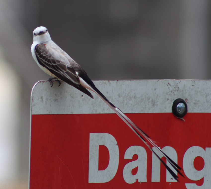
Scissor-tailed flycatcher
From the Tulsa area we proceeded to western Arkansas, where we camped outside Russellville. There’s a fantastic municipal park on the Arkansas River near Russellville, where we saw several specimens of the spectacular scissor-tailed flycatcher to which I alluded earlier. This is the state bird of Oklahoma, but I guess they’re allowed to be in Arkansas as well (their habitat is the central-southern United States, including all of Kansas, Oklahoma, and Texas).
Want to know why they’re called scissor-tailed flycatchers? Scroll on!That’s why.
(The sign didn’t say “Dang,” by the way – I cropped out the “er.”)
((The “Danger” sign didn’t refer to the scissor-tailed flycatcher, by the way – it had something to do with boating on the river.))
Prairie lizard
TALES OF THE GODDARD LIZARD ALERT: Sharp-eyed readers will have already noticed that this is not a photo of a bird. This is most likely a prairie lizard, or Sceloporus consobrinus. Note, however, that I know next to nothing about lizards, so I could definitely be wrong. Whatever species it is, there were dozens of them at the park crawling around the cement steps leading down to the Arkansas River, which obviously delighted Nancy to no end as we climbed back up. Also, we’ve seen a lot more different lizards in the last year, so prepare yourself for lots of TALES OF THE GODDARD LIZARD ALERTS.
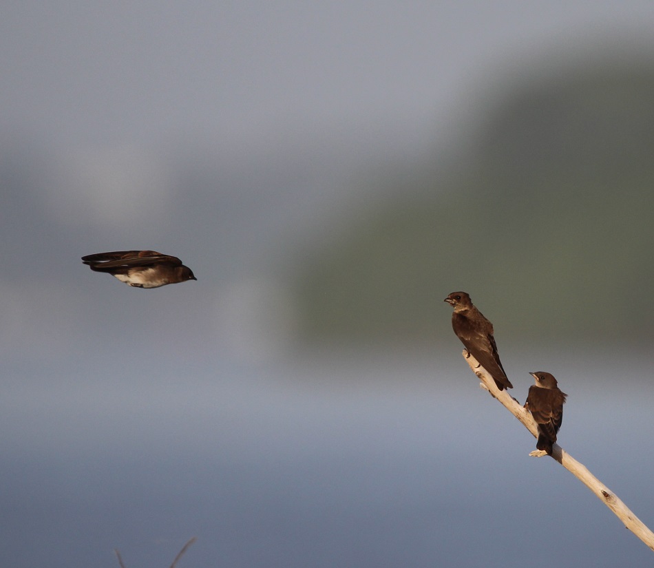
Northern rough-winged swallow
Finally, we made our way to the eastern side of Arkansas, right up next to the mighty Mississippi River, where we camped just a stone’s throw from the Mother of Waters. I’m fairly confident that these are northern rough-winged swallows (Stelgidopteryx serripennis), which were flying acrobatically over the river while hunting for flying insects. We really enjoyed watching them, along with their barn swallow cousins.This is a photo of a barge making its way up the Mississippi, just south of Memphis on the other side of the river from where we were camping. I’m including it because we spent a lot of time just watching these gigantic barges going up and down the river while hauling all kinds of cargo, and there’s also a swallow (dunno what kind) pictured just above the barge, in pursuit of a flying insect.
I kept a list of the different bird species we saw in 2022, and we ended the year with 86 species. As of this writing (late May 2023), we’ve seen nearly 70 species since the beginning of the year. Traveling about the country (although we’ve been only in New Mexico, Arizona, and, briefly, Utah in 2023) helps that number quite a lot, of course, as does keeping an open eye when one is out and about. There’s a lot of diversity out there, and it’s neat to see.
One day – I think it was a Tuesday but I could definitely be wrong – about 35 million years ago, a volcano began erupting in what is now southwestern New Mexico.
Somewhat later, on January 8, 2023, Nancy, Gunther and I visited City of Rocks State Park, located about 20 miles south of the caldera that produced the eruptions. The pumice and other rocks produced by the volcano’s eruptions 35 million years ago form the main feature of the state park, which also has a number of interconnected hiking trails, developed campsites, a botanic garden, and even an astronomical observatory.
We’d planned to visit he park, which is located halfway between Deming and Silver City, New Mexico, just a few miles east of U.S. Route 180, several times in 2021 and 2022 when we were camping in Deming and Silver City. However, the 35 mile-per-hour winds each of those days convinced us to find something else to do. The morning of January 8 was bright and calm, and we made the short trip to the state park. We’re all glad that we did.
You’ll find plenty of prickly pear cactus at City of Rocks State Park in New Mexico, along with a wide variety of other plants. In the background, a vehicle provides a sense of scale for the namesake rocks near the park’s visitor center.
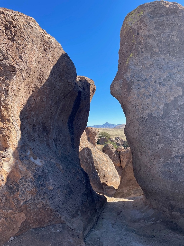
The park, at an elevation of just over 5,200 feet, gets its name from several tall outcroppings of rock that have eroded over the past 35 million years into pinnacles and other formations, separated by lanes that resemble city streets between tall buildings.
Here we see an amateur geologist, with her professional dog, on one of the park’s trails. They appear to be in disagreement about which direction to proceed. The park has about five miles of trails, some of which wind directly through the rock formations. Many of the pinnacles are 40 feet tall.
Paths between the rocks can get pretty tight. During the main phase of the volcano’s eruption, more than 240 cubic miles – about twice the volume of Lake Erie – of pumice and ash were ejected. This eruption also resulted in the “Kneeling Nun” formation east of present-day Silver City, 20 miles to the north. The pointed mountain seen between the two rocks is Cookes Peak (elev. 8,408 feet), a significant landmark in southwestern New Mexico. The mountain is directly north of the city of Deming.
The volcanic eruption that formed the formations of City of Rocks likely lasted several years and was about a thousand times larger than the Mt. St. Helens event in Washington on May 18, 1980. The eruption blanketed this area in a deep layer of hot ash and pumice. As those volcanic materials cooled into a rock called tuff, it shrank somewhat and vertical cracks in the stone were created.
They still haven’t agreed on a direction in which to hike. The park has a huge variety of succulents, like the soaptree yucca at the left of the trail, as well as many grasses common to the southwestern United States.
Over the last several tens of millions of years, the erosive forces of nature – water, wind, and organic growth – broadened the small fissures between the rocks into larger and larger crevices until the natural pathways seen today were created.
Now they’re both headed the same direction. The amateur geologist is standing in a crevice that is a conduit for water flowing through the rock formation. It’s that water, which carries abrasives like sand, that helped carve the rocks into the shapes we see today. Other contributors to the erosion include wind, which can also carry sand, as well as plant (and non-plant) life and the cycle of freezing and thawing water.
Many different groups of native Americans have lived in, or at least passed through, the area now known as City of Rocks. About 12,000 years ago, the last of the Ice Age glaciers were retreating and large mammals like mammoths and mastodons roamed this region. It’s likely that Paleoindians, like Clovis or Folsom peoples, hunted the large animals. Between 8,000 and 1,000 years ago, small bands of the Desert Archaic culture lived in the area and, toward then end of that era, began to build pit houses. Finally, the Mimbres culture occupied the area between the years 200 and 1150 AD. In addition to hunting animals and gathering food from plants, the Mimbres cultivated crops like beans, squash, and maize. They also built one-story above-ground dwellings.
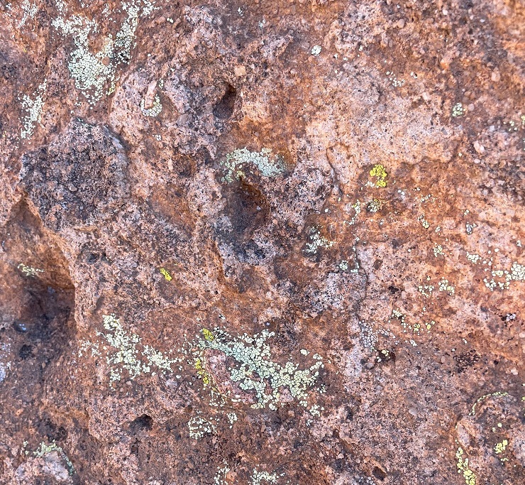
Do you like lichen as much as I’m likin’ this lichen? There are about 20,000 known species of lichen in the world, and at least four of them can be seen in this photograph. Lichen, which is plant-like but not an actual plant, contributes slowly but significantly to the erosion of rocks by chemically degrading the stones’ minerals. The scientists estimate that between 6-8 percent of the earth’s land surface is covered by lichen. Actual plants, like succulents, grasses and shrubs, also contribute to erosion by their seeds finding purchase in small crevices in the rock and then, as the plants mature, the growing roots of the organism can cause further fracturing of the minerals.
Getting up-close and personal with the rocks allows one to see some pretty fascinating natural patterns caused by erosion. I sure hope that whoever dropped those keys comes back by to pick them up! (Just kidding – they’re mine. Still need to go back and pick them up.)
Because the park is 25 miles from the nearest city of any size, it’s a popular site for stargazing at night. This structure is an astronomical observatory located near the main campground in the park. The roof slides back onto the supports in the back to reveal the telescope. It was not in operation during our visit (as you can see, it was daylight), but the park does host regular star parties during which the observatory is open and other amateur astronomers bring their own telescopes to share views of the night skies.
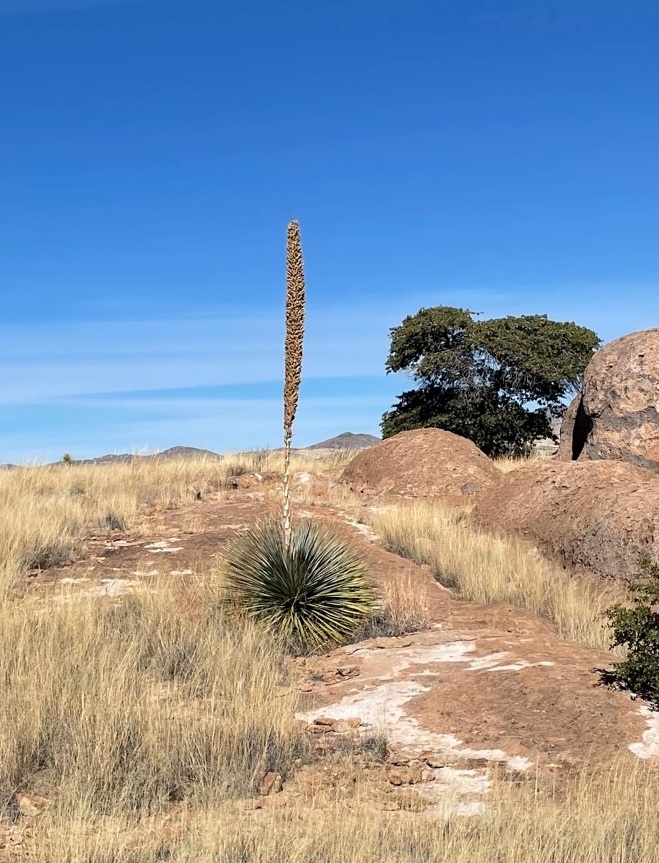
This magnificent succulent specimen, about 20 yards off the trail, is desert spoon (Dasylirion wheeleri). I didn’t want to get off the trail to take a closer picture, so this will have to do. The fronds of desert spoon were used by native Americans to weave baskets and mats, and its inner core can be fermented into an alcoholic drink, similar to tequila, called sotol. It is found in southern New Mexico and Arizona, as well as parts of Texas and Mexico. The plants themselves grow to about 5 feet tall, but the flowering spike can soar 16 feet into the air.
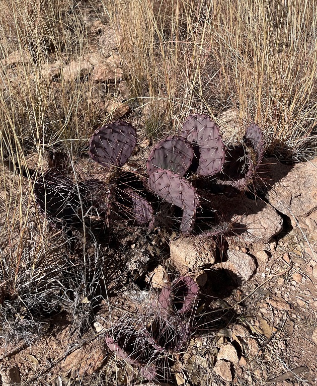
Here’s another interesting succulent found along the trail. This long-spined, purplish prickly pear is called long-spined purplish prickly pear (really) (Opuntia macrocentra). It, too, is found in Arizona, New Mexico and Texas, along with Mexico. Like other prickly pears, the fruit of this cactus is edible and is enjoyed by animals and humans alike.
But it wasn’t simply succulents we saw – we also spied several species of sparrows! Here’s a chipping sparrow (Spizella passerina) perched in some mesquite. We’ve enjoyed seeing plenty of these pretty little birds in southern New Mexico this winter.
While most of the pictures in this posting were taken with the camera on my phone, I used my digital camera to take this photo of Cookes Peak. The tall spindly shrub in the lower left corner is ocotillo (Fouquieria splendens), which can grow to more than 30 feet in height. It is native to the Chihuahuan and Sonoran deserts in the United States and Mexico. Native Americans used different parts of the plant to address a variety of ailments, and ocotillo can also be planted to serve as a natural fence.
A short spur off the main trail took us to the top of a 300-foot hill that provided a tremendous 360-degree view of the area. In this photo, the rock formations of City of Rocks are in the midground (the white streaks above the center of the photograph are campers’ recreational vehicles parked amongst the rocks, and the light brown building to the left of the RVs is the park’s visitor center). The tallest mountains on the left horizon are the Cobre Mountains, 16 miles away, and the Pinos Altos range, 30 miles in the distance, is just to the right of the Cobre Mountains.
This eye-catching grass is cane bluestem (Bothriochloa barbinodis), a valuable forage for ranchers but one of the first grasses to disappear if a pasture is overgrazed. The seed heads catch the sun in such a way as to look absolutely illuminated from within.
When we walk by a creosote bush (lower left), I like to rub my fingers on the leaves – they smell just like the air outside after a rainstorm. Along with seemingly every other plant, Native Americans found many medicinal uses for creosote. In the background is Table Mountain, the tallest point in City of Rocks State Park. The distinct layers of rock seen on the mountain’s slopes are due to different volcanic ashflows more than 30 million years ago..
If you plan to visit City of Rocks State Park, you’ll want to do make plans to do so soon-ish. The erosional forces that created the cracks between the rocks continue to degrade the stones even today (I mean, you saw all the lichen), and in several million years the whole area will just be flat.
Nancy and I definitely enjoyed our time in the park – it was a lovely day, with highs in the low 60s and very calm breezes, and the 4-mile hike gave all of us some great views and good exercise (Monday, January 9, was a day of relaxation and recuperation for Gunther). We plan to take the Goddard to the park in the next few years for some actual camping – it has more than 40 developed sites – and it has some other trails that we haven’t yet enjoyed.
St. Vrain State Park had its beginnings in 1958 when the Colorado Department of Transportation bought some land around St. Vrain Creek to mine gravel needed for the construction of highways in the area. The mining projects left wide but relatively shallow holes in the ground, many of which filled in from the low water table of the St. Vrain. Over the years, more mining companies extracted more gravel, and now St. Vrain State Park has eight ponds and reservoirs, along with 87 campsites in eight different campgrounds. The state park is a popular destination for campers along Colorado’s Front Range; it’s just an hour’s drive from our former house in Denver. We camped there in our former trailer every April for a decade before becoming full-time RVers, and we returned to the shores of St. Vrain State Park in early May 2022.
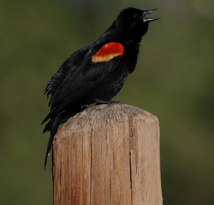
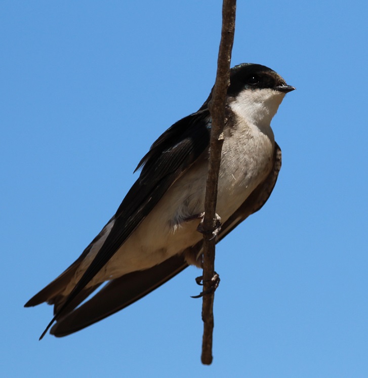
St. Vrain State Park is a bird enthusiast’s dream destination. The park’s literature lists more than 200 bird species that can be seen in the park’s ponds, wetlands and meadows. Not all of those species are in the park at once; many use the ponds as a migratory rest area on their way to points north or south of Colorado, and others stay in the park for a few weeks or months out of the year. We saw more American white pelicans in the park in 2022 than we had in previous years. Watching them float noiselessly on the surface of the water is a very relaxing experience. When we were camping along the west bank of the Mississippi River in Arkansas a few weeks later, a flock of about 200 pelicans darkened the sky as the birds flew overhead.St. Vrain State Park is the largest great blue heron rookery in Colorado. Great blue herons are relatively common sights along the banks of the larger ponds in the park; they usually fly off if approached. If one is patiently quiet and still, however, it’s possible to see a heron catch a fish in the shallows. The largest of the heron family, great blue herons can grow to 4 1/2 feet tall and weigh more than five pounds, with a wingspan of 6 1/2 feet. I photographed this one on an early foggy morning on the bank of Sandpiper Pond. Whenever I think of St. Vrain State Park, the first bird that comes to mind is the red-winged blackbird. Their distinctive call (you can hear it at the soundfile below) can be heard throughout the park practically all day long, but especially in the early morning hours. While I’ve seen red-winged blackbirds perch on waving reeds and cattail stalks, in addition to tree limbs, this one found a solid fencepost upon which to belt out the hits. This is a bird species in which the males and females look nothing alike. This is a male blackbird; I’ve mistaken female blackbirds for some type of sparrow because they share the same light and dark brown markings.We were happy that our friends Mary and Robert, and their German shepherd, Otis, could camp at the site next to us on one of the weekends we were at the park. Mary, Robert, Otis and I took a walk one morning around Blue Heron Reservoir, the largest and newest of the lakes at the park, and happened to spot this guy out in the water. This photo of a western grebe isn’t great – it was 50 yards out and drifting further away – but it’s an interesting bird. They dive underwater to catch fish, which is their main diet, and it’s kind of fun to guess where they’ll pop up to surface. One of five grebe species that visits St. Vrain State Park, I’d also seen this species at Lathrop State Park near Walsenburg in October 2021.This well-camouflaged little bird is a song sparrow (I’m pretty sure; there are many varieties of sparrows and most of them look at least a little alike). It was hunting for bugs one evening along the banks of Mallard Pond. Click the link below to see why they got their name.Nancy and Gunther and I went on a longer hike one Saturday morning and saw a pair of tree swallows feeding their young nestlings inside a tree cavity. This is the female of the pair, who was hanging out on a tree limb and watching her mate feed their kids in the tree. She’s got just a hint of iridescent blue coloring on her head, whereas the male tree swallow is mostly blue. Like other swallows, their diet is mostly bugs that they catch while flying in the air; unlike other swallows, they also eat berries which allows them to make it through winter much easier.I took this photo of a female brown-headed cowbird a few minutes’ walk down the trail from the swallows’ nest. Cowbirds used to follow bison herds in the American West and forage on insects that were kicked up by the animals’ hooves. These days, they do the same with cattle herds and they’re found from coast to coast. This species has a fairly poor reputation among bird enthusiasts: it doesn’t build a nest in which to lay its eggs but instead lays its eggs in the nests of other bird species. This parasitism, which is practiced by only a few other birds, results in reduced numbers of other songbird species. I’ll be the first to state that this is a terrible, terrible photo. However, there is a story behind it: a little while after taking the photo of the brown-headed cowbird, we looked up and saw what we thought was a flock of Canada geese flying overhead. I took a picture of part of the flock, and I really don’t know why. After our hike, I looked at the photo on my laptop’s screen and realized that those weren’t Canada geese. Look at the beaks of the birds (they’re flying toward the right side of the photo): they’re very long and slightly curved. I thought they might be ibis (ibises?), and I looked at the park’s literature to see if ibis were ever sighted in the park. Turns out white-faced ibis do indeed migrate through St. Vrain State Park! Here’s a link to an Audubon Society page so you can see what these beautiful birds really look like.I know some readers of this blog frequently drive on I-25 between the Denver metro area and the northern reaches of the state. This is what’s beneath the bridges just north of Exit 240: thousands upon thousands (not kidding) of cliff swallow nests (those brownish smudges are the cliff swallows returning to feed their nestlings; I couldn’t get any decent photos of the birds themselves because they move so fast). The swallows have built the nests here to take advantage of the great biomass (bugs) available at the ponds and lakes of St. Vrain State Park. It’s important, I think, to remember just what a huge service that bug-eating birds do for us: imagine how many more grasshoppers, caddisflies, and mosquitoes we’d have to deal with were it not for these feathered friends of ours. The hike that Nancy and Gunther and I went on was chock-full of nifty birds we hadn’t seen before. I had no idea what this was when I took the photo, but I could tell it wasn’t a seagull. Again, after returning to the Goddard, I looked it up. It’s a Forster’s tern (might be another species, the common tern, but Forster’s terns are, inexplicably, more common than common terns). This was an incredibly acrobatic and fast flyer, and much fun to watch during its migratory stopover at the park.I took this photo of a beautiful barn swallow on the same morning that I took the photo of the great blue heron. The lighting, because of the fog, wasn’t great, but I was happy to see this little fellow light for a few minutes on a stretch of fence. Swallows of all kinds are very aerobatic flyers – they dip and whirl about while chasing bugs over bodies of water. We would see yet another species of swallow, the northern rough-winged, while camping on the Mississippi River in mid-June. There are six species of swallows, including the northern rough-winged, that visit St. Vrain State Park either on a seasonal or migratory basis. Over the years I’ve probably taken a hundred photos of double-crested cormorants, but they’ve all been taken when the birds are too far away from shore to turn out very well. They seem to like the company of pelicans while swimming (or perhaps they’re opportunistic feeders taking advantage of the schools of fish found by pelicans), but they’re much more timid than the big white birds and stay further from shore. They also take flight well before the pelicans do. The stars aligned during our trip to St. Vrain State Park in May, and I finally got some photos that aren’t embarrassing to share. During our stop I also figured out why these birds look so odd while swimming: unlike pelicans, or ducks, or geese, or pretty much any other waterfowl, they keep most of their bodies submerged. I think cormorants are one of the greatest visual reminders that, in a way, dinosaurs still walk the earth. This guy would not look out of place as an extra in a Jurassic Park movie.I’ll close with one of the best photos I’ve taken in a good long while. St. Vrain State Park is home to several pairs of nesting ospreys, which return to the same nest year after year, and the number appears to be growing. I noticed a new osprey nest (really not that impressive; it looks like a pile of trash and twigs because that’s what it is) along the road leading into the park, and asked a ranger about it. Turns out that the nest had delayed construction of a section of a long-planned hiking and biking trail that winds its way along the I-25 corridor, at least until the osprey fledglings had left the nest. True enough, work on the trail appeared to recommence a few days before we left, so I guess the fledglings had left home. Anyway, this osprey pictured was perched above Mallard Pond one late afternoon when the sun happened to be shining for a few minutes during an otherwise overcast day. It’s obviously used to passersby, but it’s a beautiful raptor nonetheless. The ponds and lakes have plenty of fish for both anglers and birds, like pelicans, and terns, and grebes, and cormorants. It’s fun to watch a grebe pop out of the water with a fish in its beak, but watching an osprey slam into a lake, talons outstretched, and then lift away with a trout in its grasp is a fantastic experience.
In the two weeks we were at St. Vrain State Park, we saw 26 different species of birds, including five, like the tern and ibis, I’d never seen before at all. We don’t have immediate plans to return to the park, but I don’t doubt that we will go back sooner or later. It’s a great place to unwind, and, although it’s close to I-25, it provides plenty of opportunities to get to know a tremendous variety of our feathered friends.
The Goddard spent the fall and winter of 2021-2022 in New Mexico and then Arizona, and in the spring we headed back north to visit Colorado for a while. Spring is a great time to watch birds: they’re very active as they gather material for nests and later find food for their fledglings. Leaves on trees also begin to emerge as the weather warms up, which I was to discover makes photographing birds much more difficult than in the fall and winter.
Here are some birds we saw doing their spring thing in Arizona, New Mexico, and Colorado.
Holbrook, Arizona
Our campground in Holbrook was next to a residential area, which doesn’t happen very often because usually campgrounds are on the outskirts of towns. It gave us a chance to walk by houses and see birds perched in the trees.
This female house finch was busy gathering materials for a nest at our campground in Hollbrook. Finches have really pretty songs, and they’re enjoyable to listen to in the morning. House finches are an interesting story: they’re native to the American southwest and Mexico, but profiteers captured some finches in the 1940s and attempted to sell them as “Hollywood finches” to bird enthusiasts in New York City. Rather than face prosecution for violating a federal law regarding migratory birds, the people released the finches into the wild and the birds established themselves on the U.S. east coast. In the ensuing years, they’ve moved both east (from the southwest) and west (from the east coast) to be found across nearly the entire country.Here is the mate of the house finch, watching the sunrise the same morning. I’m sure he later helped build the nest, too. The reddish coloration of male house finches changes with the seasons and is dependent on the birds’ diets; as you’ll see, some male house finches are redder than others. For their size, finches have some powerful beaks.This is a very common bird, the house sparrow, but it’s a very pretty one all the same. Mornings are a great time to take photographs of birds because the sun is low in the sky to provide dramatic lighting, and the birds themselves are fairly active.
Grants, New Mexico
The campground at which we stayed in Grants, New Mexico, at the end of March had an adjacent walking trail that wound through a lava field. A relatively recent volcanic eruption, perhaps only 4,000 to 5,000 years ago, produced the black basaltic rock that is everywhere around Grants. The campground’s trail attracted a lot of birds that perched on the trees and shrubs within the lava field, including this female white-crowned sparrow that was singing a pretty song one morning. It was the fifth species of sparrow I’d seen during our stays in New Mexico and Arizona. We really enjoyed this trail, which also provided great views of the surrounding mountains. A national monument, El Malpais (Spanish for “the badlands”) is very near Grants, and we look forward to visiting it in the future.Here’s the other male house finch I alluded to earlier. Dunno what he’s eating to get all of that red coloration, but he’s definitely the reddest finch I’ve ever seen. This was in the campground at Grants; I have a bunch of photos of different birds perched on different types of water valves at campgrounds, for some reason.
Albuquerque, New Mexico
Our next stop on our return north was Albuquerque, which Nancy and I really enjoy visiting. There’s a lot to see and do there, and plenty of great Mexican restaurants and grocery stores to enjoy.
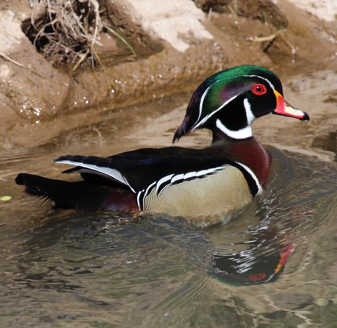
We returned to Albuquerque’s excellent Botanic Garden at the city’s BioPark, which also has a zoo and aquarium situated along the Rio Grande near downtown. In early April the garden had thousands of blooming bulbs, including daffodils, tulips, crocus, and others, as well as a lot of neat birds. This is a male white-crowned sparrow; compare him to the pretty female white-crowned sparrow from the Grants lava field, two photos above. This guy was hunting for bugs on one of the garden’s trails.We watched this mountain bluebird bring a grub to its nest in a tree near the Botanic Garden’s farmstead exhibit. I really like the hue of blue, which contrasts nicely with their rusty chests, on these birds.Gunther and I went for a walk on a trail along the Rio Grande bosque one afternoon and I heard this fellow singing in a cottonwood tree. I couldn’t tell what kind of bird it was at the time because it was so far away, but I got a couple of photos with my telephoto lens. I was a little surprised to see, after looking at it on my laptop, that it’s a spotted towhee. I’d never seen one in a tree before; I’ve only seen them on the ground, scratching through leaves while looking for bugs. (Of course, the next day we went to the city’s Botanic Garden and we saw another spotted towhee there, in a tree.) Spotted towhees are really pretty birds – they’ve got a lot of patterns and colors going on.On that same walk we saw several wood ducks, including this very striking drake, swimming in a canal adjacent to the Rio Grande. I’d never seen wood ducks prior to our first stop in Albuquerque last November. They’re just incredibly beautiful birds (and the hens are quite pretty as well).
Las Vegas, New Mexico
In mid-April we made our way to Las Vegas, which we had also stayed at the previous fall. It was incredibly windy during our stay there in the spring (and the area would be subjected to several wildfires shortly after we left), so we didn’t venture out much. I did take a few photos at the campground, though.
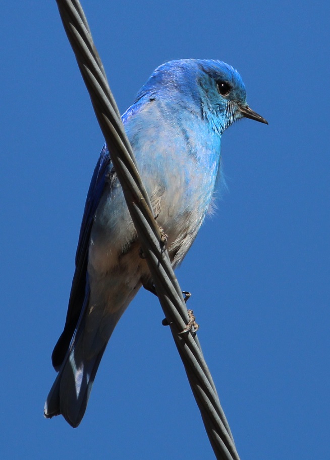
This is a western bluebird, perched on a power line and watching me as I watched it. This is the same species from the cottonwood tree in the Albuquerque Botanic Garden. I’m writing this post while camping in central Arkansas, and I kind of miss those clear blue skies of New Mexico and Arizona. We sure don’t miss the wind, though.Writing about blue skies: this mountain bluebird nearly disappears into them. We’ve seen this species in Colorado several times, including at the cabin near Eleven Mile Reservoir. You can see that the wind was blowing: look at the feathers on his chest.
Lathrop State Park, near Walsenburg, Colorado
We returned to Colorado around the end of April, choosing to camp once again at one of our favorite state parks. Located west of Walsenburg in the southern part of the state, Lathrop State Park has two large lakes, good hiking trails, and incredible views of the Spanish Peaks and Blanca Peak, each of which still had snow. The park attracts an enormous number of permanent and migratory birds each year.
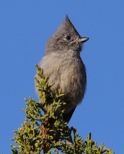
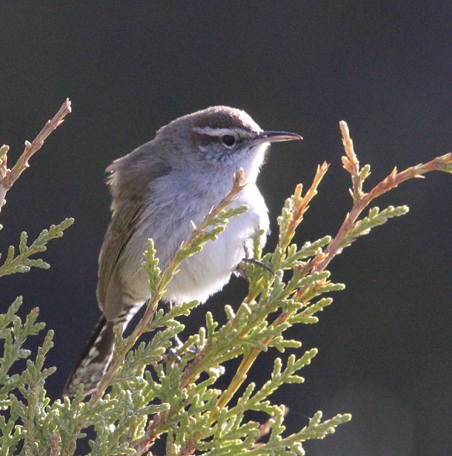
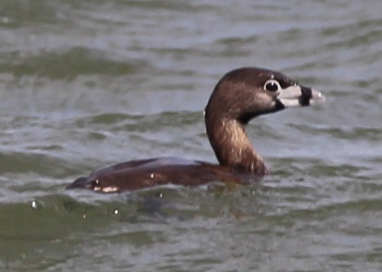
We’d seen a couple of American robins, our first of the spring, at the Albuquerque Botanic Garden, but I couldn’t get any good photos. There were plenty of robins at Lathrop. I’ve learned to recognize their calls, which are really distinctive once you’ve heard them enough.I hiked through the cactus and brush (you’ll notice that most of these songbirds at Lathrop are perched on juniper) north of our campsite one morning and took this photo. I had no idea what kind of bird it was until I looked it up: it’s a tufted titmouse, at the very northern edge of its range in southern Colorado. I’d never heard of them, let alone seen one before. Neat-looking bird, although you don’t see many species, outside of bluebirds and blackbirds, that are all one color.Here’s another new bird to me, from the same morning hike: it’s a Bewick’s wren. I couldn’t get on the other side of it to take advantage of the morning sun, but I kind of like this backlit effect anyway. I’d never seen too many species of wrens before we started full-timing in the Goddard; I’ve since seen several, and they’re very attractive little birds.This is a cropped photo taken with a telephoto lens from a long, long way from this bird, but I’d never seen one before. This is a pied-billed grebe swimming on one of the park’s lakes, and it spent more time submerged than swimming on the surface. I saw eight bird species at Lathrop State Park that I hadn’t yet seen in 2022, and three of them (the last three pictured) were species I’d never seen at all.There were lots and lots of chipping sparrows at Lathrop. I’m not sure if there were more of these or if there were more American robins at the park (and there were a lot of blackbilled magpies, too). Very pretty calls from these little birds.
By the time we left Lathrop State Park on April 24, I’d seen 51 different species of birds in three different states in 2022. It had become obvious that being around water, whether it’s a river or a lake, greatly increases both the chance of seeing birds and the opportunity to see different species of birds. That would become even more clear at the next Colorado state park at which we’d camp.