El Malpais (pr. el-mal-pie-EES) National Monument, located near the town of Grants in northwestern New Mexico, showcases a number of different geological features in its nearly 180 square miles – but it’s best known for its impressive lava flows dating from 60,000 to only 4,000 years ago.
While Native Americans have lived in the El Malpais area for 12,000 years, early 17th-century Spanish explorers coming north from Mexico found the region nearly impassable by their horse-drawn wagons and carts. Those explorers gave the region its name, which means “the bad land” in Spanish and refers to the rocky topography left behind by the extensive lava flows.
El Malpais National Monument was established on Dec. 31, 1987, and about 100,000 people visit it each year.
We camped for a week in Grants and visited several different features of the national monument. The highlight, however, was a great hike that took us to the top of a cinder cone from which much of the monument’s lava had flowed.
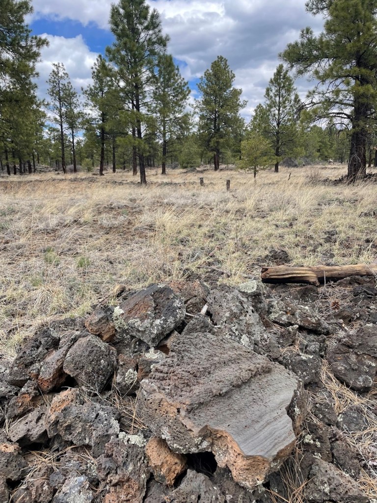
The El Calderon Trail is located on the western side of the national monument – it happened to be only a 20-mile drive from Grants. We’re still trying to adjust to being on trails that aren’t in Colorado: there were two other vehicles in the trailhead’s parking lot when we arrived at 10 AM, and in the entire course of the 5-mile loop hike, we saw nearly as many dogs (two) as we did people (three).
This iGoogle Maps satellite image, in which a quarter-inch represents two miles, shows nearly the entirety of El Malpais National Monument. The monument’s visitor center fs indicated at the top, and just to the left is the town of Grants, New Mexico, where we parked the Goddard for a week in April 2024. Grants is on Interstate 40 about halfway between the Arizona/New Mexico state line and the city of Albuquerque, New Mexico. Everything represented in dark greenish-black in the lower two-thirds of the image is basalt, or lava rock; the greenish hue is provided by plant life amongst the basalt. The town of Grants, too, is surrounded by basalt.
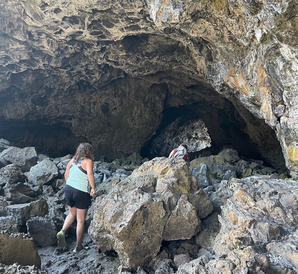
Shortly after the trailhead, the El Calderon trail passes by several caves that are actually lava tubes and are now home to bat populations. Lava tubes are formed when flowing lava exits an existing lava vent covered with a roof of lava rock, leaving behind a cave-like structure.
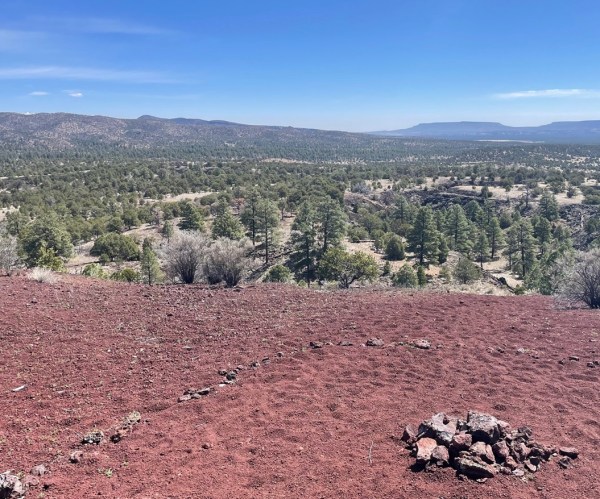
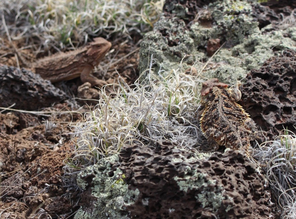
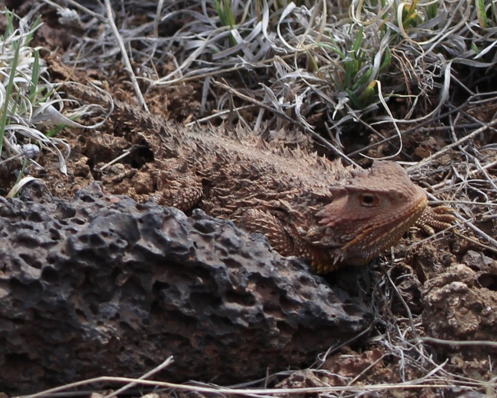
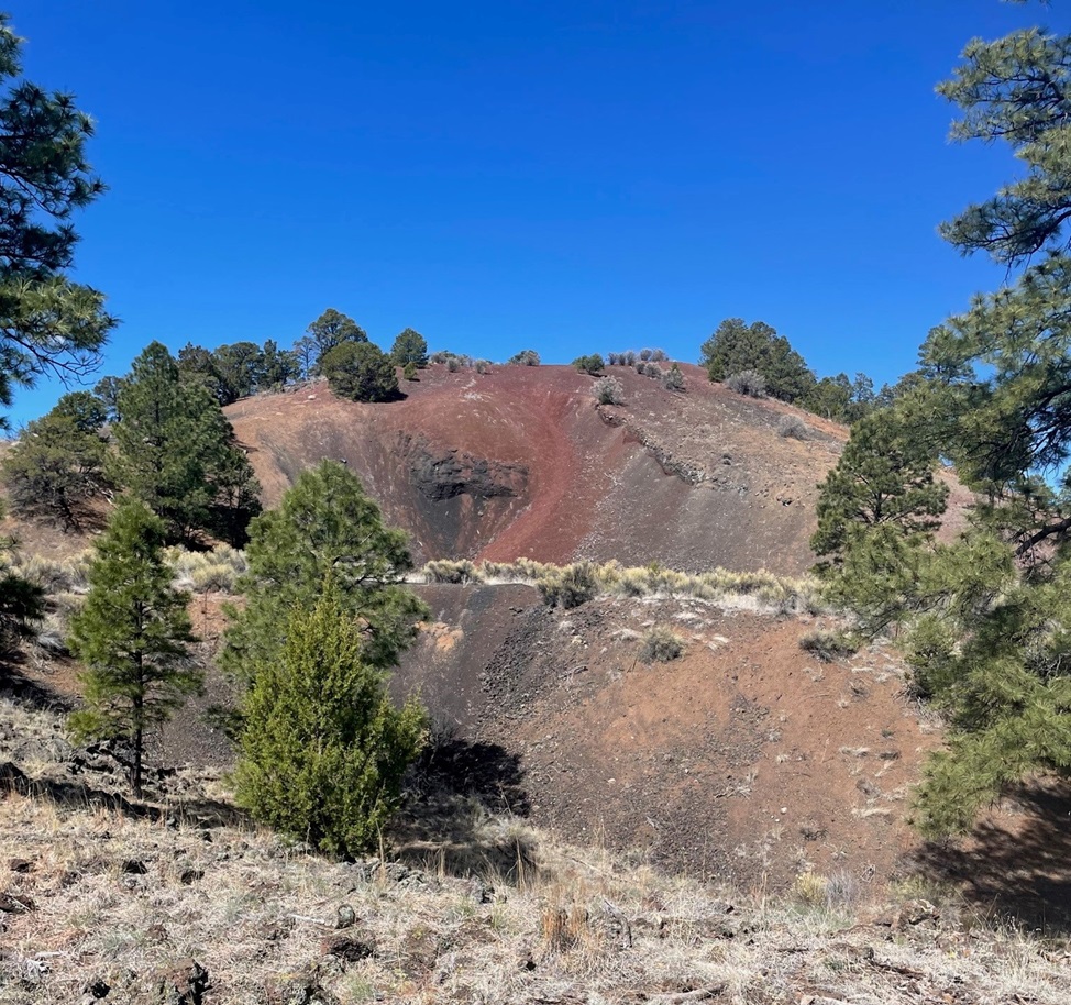
Here we see a brave hiker (it’s Nancy) at the entrance to Bat Cave in the national monument. This lava tube is a summer home for thousands of Mexican free-tailed bats that emerge at night to hunt for insects. There is still evidence of a guano mining operation in Bat Cave; bat droppings are high in nitrates and therefore valuable as fertilizer. We learned at Mammoth Cave National Park in Kentucky that guano was also once used in the production of gunpowder. To protect the flying mammal population, Bat Cave in El Malpais National Monument is closed to human visitors.Much of the El Calderon trail looks like this: relatively flat, with expansive views, through a moderately wooded forest with several different species of pine trees and evergreen shrubs.There weren’t many wildflowers in bloom when we hiked the El Calderon Trail on April 20, but we’d just missed the blossoms of the tree cholla (Cylindropuntia imbricata). Also known as cane cholla, this cactus typically grows to a height of 3 feet, but can reach 15 feet. The flowers are a very bright magenta color, and the yellow fruits, shaped roughly like a pinecone, can last on the plant for a long time. They apparently don’t taste great, but the Native Americans of present-day Arizona and New Mexico did use them as a food source.This is a TALES OF THE GODDARD LIZARD ALERT. I’d walked by this pair of horned lizards on the lava rocks lining the trail without seeing them but they didn’t escape the notice of Gunther, who Nancy had on a leash behind me. I was able to get several photos of them before we moved on down the trail. Their camouflage really is amazing – if they hadn’t moved as I passed by, Nancy said Gunther probably wouldn’t have seen them either.This is a close-up of the lizard in the background of the above photo. There are 21 species of horned lizards in the world, 15 of which are native to the United States. Five of them reside in El Malpais National Monument, and, without being familiar with any of them, I’ll just say this is one of those five species (although based on the coloration and locality I’m leaning toward a greater short-horned lizard, or Phrynosoma hernandesi). Horned lizards are often called horned toads, but they’re not toads or even amphibians at all: they are reptiles. It’s somehow reassuring to know that dinosaurs still walk among us, however small they may be. Females of the short-horned lizard species grow to about 7 centimeters (2.75 inches) SVL, while males grow to only 5 centimeters SVL. What’s SVL, you ask? I had to look it up as well: it’s an abbreviation for a herpetology term called snout-vent length (basically the length of the lizard not including the tail).The entire trail was lined with readily available lava rocks, which made for interesting viewing while hiking because of all of the different textures. Each was different, but the trailbuilders used rocks that were roughly a foot in height and width. One can only imagine the scene 115,000 years ago, when these rocks were being created: what did it look like, sound like, and smell like?We’ve seen plenty of lava tubes in Hawaii, Idaho, and now New Mexico, but I don’t think we’ve ever seen a distinct lava trench. They are formed in the same way as lava tubes, but the roof of the tube collapses soon after the lava of the tube cools. Water collects in the bottom of these trenches, allowing trees and other foliage to grow larger than their counterparts outside the trench.This is the side of the El Calderon cinder cone, from which rivers of magma flowed about 60,000 years ago to create immense rivers of lava that found their way 20 miles north to the present-day town of Grants. A cinder cone is formed when gravel-sized bits of lava are shot hundreds of feet into the air from a volcanic vent in the ground. The billions of tiny cinders fall back to earth and eventually form a cone-like structure; El Calderon is 300 feet high. The two different colors of cinders – red and black – indicate different mineral composition and different eruption periods. The trail includes an optional loop around the top of the cinder cone — it was a 300 foot gain in elevation, but the views were well worth the effort.This is a view looking northeast from the top of the El Calderon cinder cone (the side of the cinder cone pictured above is directly below this position). The red cinders contain high levels of oxidized iron: essentially, rust. On the far left of the photo one can just barely make out the snow-covered top of Mount Taylor (elev. 11,305 feet), about 30 miles away on the other side of the nearer hills. Mount Taylor is an extinct volcano that last erupted about 1.5 million years ago – long before the volcanic activity on El Malpais National Monument occurred. It is a mountain sacred to a number of Native American pueblos, including the Acoma, Zuni, Hopi, Laguna, and Navajo.This is a view looking down into the interior of El Calderon, fairly close to where the previous photo was taken but in the opposite direction. It’s a peaceful basin filled with pine trees and grasses now, but it was the source of all of those lava cinders shooting upwards into the sky when the volcano was active 60,000 years ago. El Calderon translates to “the cauldron” in Spanish.Time for lunch – trailside! We heard, but could not see, a couple of different birds singing in some nearby pines during our lunch. Afterwards, I got a couple of pictures of them. The pictures didn’t turn out well at all (they were still far away and the skies were overcast), but it turns out that they were gray flycatchers (Empidonax wrightii), and, judging by the grass in their beaks, they were building a nest.We saw these white growths on nearly every rubber rabbitbrush (Ericameria nauseosa) plant we saw on the hike. Nancy asked what they were and I replied that they were spider egg cases, each just waiting to pop with up to 100 individual spiderlings. She refused to believe me, which was probably the right thing to do, but it meant that I later had to look up what they really are. It turns out my wild guess wasn’t very far from the truth: they’re called galls, and they are home to larvae of a fruit fly. The galls, produced by the plant’s reaction to irritating chemicals introduced by the parasitic insect, act as both a home and a food source for the larvae. They don’t appear to harm the rabbitbrush plant at all.It’s a little difficult to make out in this picture, but there’s a tree species we weren’t expecting to see in northern New Mesico on the other side of the fallen log, just left of center. It’s an aspen tree, which is made possible by what the scientists call “the edge effect,” or additional moisture that collects along the area where lava fields meet conventional landscapes. The edge effect allows plants that need additional moisture, like aspens, to thrive in otherwise harsh environments.I thought the smooth side of this hunk of basalt was interesting: it indicates that the lava was moving fairly quickly as it cooled. Lava fields, after they cool and begin to erode, make for fairly good habitat for plants: the basaltic rocks hold a lot of water and trap a good variety of airborne seeds.The skies above us unfortunately still chose to be overcast when we saw this western bluebird (Sialia mexicana) perched on an oft-used branch, but the bird’s bright colors still impressed us. Western bluebirds are members of the thrush family, and their diet consists of worms and berries found on the ground as well as insects plucked from the air.The trail on the right side of this photo is the 2,700-mile-long Continental Divide Trail, which meets and shares some distance with the El Calderon Trail. If one were to follow that path, one would wind up at the Canadian border with Montana. We elected to continue on our loop to the El Calderon trailhead instead.
The hike to El Calderon was one of the more rewarding trails Nancy and I have been on in a long time: fantastic views, lots of fascinating geologic features, a good variety of plants, and a bit of wildlife to observe.
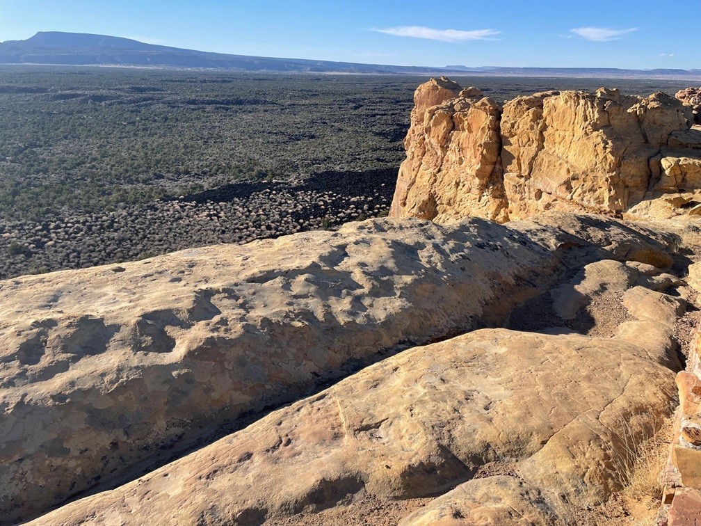
There is a lot of geology to appreciate about El Malpais National Monument, and not all of it has to do with lava. On a weekday evening, Gunther and Nancy and I drove to the east side of the monument to see two sandstone features: La Ventana and a sandstone bluffs overlook.
About 160 million years ago, the El Malpais area looked a lot like today’s Sahara Desert: covered with hundreds of feet of sand that, compressed by other layers of sediment, eventually formed sandstone. This arch, formed by the weathering effects of freezing and thawing water trapped in the sediment over millions of years, is 135 feet across and only 25 feet wide at its thinnest point. Spanish explorers called this arch “La Ventana,” or “the window.” It is one of the largest natural stone arches in the state of New Mexico.This is a sandstone bluff overlook that provides great views of the basaltic lava flows hundreds of feet below. More than 200 volcanic vents have been identified in the national monument, and this sandstone is tens of millions of years older than any of them.
Nancy and I both have more than a passing interest in geology, and especially volcanoes, so El Malpais National Monument was a great place to spend a week. We spent the summer of 2023 surrounded by volcanic features in Idaho, and it was fun to once again be amongst these reminders in New Mexico that our planet continues to reshape itself all the time.
Craters of the Moon National Monument, located midway between Twin Falls and Idaho Falls in the south-central part of Idaho, is one of those National Park Service sites that you kind of have to want to get to. The monument and its associated preserve receive only about 220,000 visitors each year; for comparison’s sake, Rocky Mountain National Park northwest of Denver receives more than 4 million visitors annually. Craters of the Moon is not on any Interstate highways, and it’s about 90 miles from Twin Falls and more than a two-hour drive from Idaho Falls. I imagine many of its visitors are on their way to or from Yellowstone National Park, which gets about 3.3 million visitors each year.
Thousands of years ago, these rocks were part of a slow-moving river of magma. Craters of the Moon National Monument doesn’t have especially tall volcanoes – it has about 20 cinder cones that top out at about 700 feet in height – but it does have immense flows of basalt resulting from lava that escaped through fissures in the earth. As they cooled, the magma flows hardened into these beautiful rock structures.
Still, it’s a unique and beautiful place that clearly shows that the area was the site of tremendous volcanic activity in the planet’s relatively recent past. We parked the Goddard in Arco, Idaho, about an hour’s drive northeast of Craters of the Moon and visited the monument not once but twice in a week. Why? Lava! And cave-like geologic structures!
The year 2024 marks the hundredth year since the establishment of the monument. The monument and preserve protects 753,000 acres (about 1,200 square miles) of south-central Idaho for visitors to experience what it could be like to walk on another world. The scientists have dated some of the lava flows and have determined that the area experienced an extended period of geologic activity – and one that was quite recent, geologically speaking. The oldest lava flows yet recorded are from eruptions 15,000 years ago, and the most recent flows occurred just 2,100 years ago.
Our first impression of the national monument: everything is black, due to the miles and miles of basalt that’s all around. It’s really difficult for plant life to establish itself in relatively new basaltic soil; total vegetation coverage on the entire monument is less than 15 percent, and on cinder cones like this it’s only 5 percent. Here we see an intrepid hiker (it’s Nancy) making her way up the slope of Inferno Cone, a tall cinder cone in the monument. Cinder cones are the most common type of volcanic structure on Earth. The lava emissions at what is now Craters of the Moon were less explosive than many other eruptions around the world, so the slopes of the cinder cones are gentler. It’s a little less than a half-mile to the top of the cone, from which one can see 360 degrees all around Idaho (and on especially clear days even the peaks of the Teton Range, 100 miles away in western Wyoming, can be spotted). The sun, pictured in the upper right of this image, is no joke: its rays can heat the black basalt to temperatures of 150 degrees. Winters can be harsh as well, with plenty of snow and frigid temperatures.
Craters of the Moon contains the largest lava field in what is known as the Great Rift, a 53-mile-long fissure in Idaho running from the southeast to the northwest. The relatively quiet (as quiet as a volcanic eruption can be, anyway) release of gas and magma created these lava flows over a period of many thousands of years. This part of Idaho has several other such lava fields and the soil that has resulted from those older flows results in regions famed for growing fine potatoes. (There were a couple of grocery stores in Idaho in which the smallest baking potatoes weighed a pound.)
In time, the soil in the national monument may break down enough (through the work of erosional forces like wind, water, and plant growth) to allow more plants to survive. Until then, it’s pretty desolate but in a beautiful way, and any potato harvests in this particular part of Idaho will be many years in the future. Incidentally, it’s believed that the caldera underneath Yellowstone National Park, which is responsible for the geysers, paint pots, and other hydrothermal features there (and possibly a mass extinction event if it erupts while humankind is still around), is connected to the hotspot that created Idaho’s lava fields. Over millions of years, the North American Plate has been moving slowly while the hotspot heats up the landform currently over it: 10 or 11 million years ago, that hotspot was underneath what is now Craters of the Moon National Monument.
In order to survive, plants and animals have to be extraordinarily adapted to make it in both extreme heat and cold. This is dwarf buckwheat (Eriogonum ovalifolium), a plant only four inches tall that can boast a root system up to three feet in diameter. That root system works to get as much moisture to the rest of the plant as it can, and this plant is so efficient at doing so that plants can’t survive within about three feet of each other – they wind up being so evenly spaced that they appear to have been hand-planted. Additionally, the plants light-colored leaves reflect, rather than absorb, the sun’s rays. Note the texture of the black basaltic soil.
Craters of the Moon was established and named as a national monument almost 50 years before NASA put astronauts on Earth’s actual moon, so it wasn’t until the very late 1960s and early 1970s that it was discovered that the moon’s surface isn’t anything like southern Idaho. The moon has been shaped by impacts of meteorites rather than volcanic eruptions. But the national monument did serve as an ideal training ground for astronauts so they could practice selecting rock samples in an unfamiliar environment.
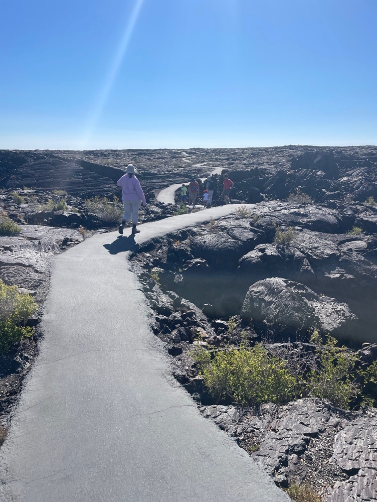
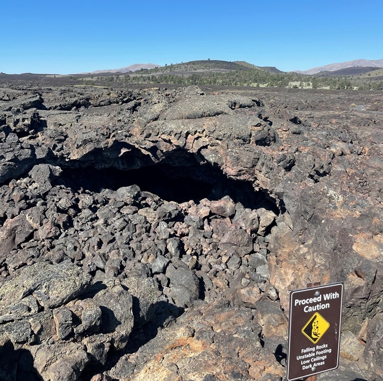
While we hiked up Inferno Cone, we saw a few turkey vultures (Cathartes aura) circling in the beautiful blue sky and perching in this dead limber pine tree. I took several pictures of this bunch, but they apparently had more important things to look at than me and they never turned around. These birds can have wingspans of up to six feet in length. Turkey vultures aren’t the most attractive representatives of the avian world, but their diet of nearly exclusively carrion is essential to preserving the natural order of things.This is known as a spatter cone, formed when jets of lava spout vertically from the earth – for scale, that’s a person on the trail in the shadow of the cone. The monument and preserve contains about 25 cones of the spatter and cinder (such as Inferno Cinder) varieties.We happily joined a ranger-led hike to some lava tubes. We’d seen lava tubes in Hawaii many years ago, and were more than a little surprised to see them again in Idaho. This was a pretty nifty asphalt trail that wound through the basalt formations and led to the tube structures.Here is the opening to a lava tube that we didn’t enter, and you can probably see why we didn’t. The jumble of large rocks near the opening are the result of the overlying rock atop the tube collapsing into the void and down to the ground. This lava traveled 18 miles from its source, the spatter cones pictured above.Here’s the lava tube that we did enter. It was a really impressive cave-like structure, formed when a river of lava continues to flow underneath a layer of magma that has already hardened on top of it. When the supply of lava is cut off, the opening through which the lava flowed remains to form these interesting structures. The empty spaces are home to bats, just like a cave. We didn’t see any bats, but I did capture a photo of a rock pigeon in the lava tube. You know what a rock pigeon looks like, so I won’t post it. It was kind of neat to see a species of bird that’s common on big-city streets in a lava tube in very rural Idaho, though.While the first day we visited the national monument was clear with blue skies, the second day was mostly overcast and chilly. On a short hike around the lava flows, we saw several of these birds performing some impressive aerobatic maneuvers, presumably catching insects in flight. We couldn’t tell what kind of birds they were until this one landed in a tree. It’s a nighthawk, of which there are several species in North America. I don’t know which particular one this is (I’m guessing it’s a common nighthawk), but we were pretty excited to see it – we’d never seen a nighthawk before. They’re a mostly nocturnal species, so maybe the cloud cover was enough to make them active during the day.One of the hiking trails we enjoyed led to this impression of trees that were growing thousands of years ago and then were downed in the flowing magma, leaving behind these distinct patterns of bark growth in the basalt.I didn’t take this photo at the national monument, but rather at the campground in Arco where the Goddard was parked. I’m including it because it was another new-to-us bird, a plain-looking little fellow with the splendid name of western wood-pewee (Contopus sordidulus). They are about six inches long, weigh just a half-ounce, and have a wingspan of about 10 inches. Like other birds in the flycatcher family, this species is particularly skilled at snagging insects in flight.
Craters of the Moon National Monument has a lot going for it, and we were fortunate to be able to include it in our summer 2023 itinerary. We saw plenty of other places with lava flows both (relatively) new and old in Idaho – we spent more than two months in the southern and southeastern part of the state – but it was fun to be able to walk across the basalt and wonder what the environment must have looked like when the lava was flowing. Interestingly, the volcanic features at Craters of the Moon are believed to be only dormant – not extinct – and geologists expect the region to become active once again within the next thousand years, and some believe it could be within the coming century.
From scenic Tennessee, the Goddard hurtled northward in the summer of 2022 – destination: Michigan, to visit Nancy’s sisters and their families. On the way, we stopped to visit a couple of national parks in Kentucky and Indiana. We’d visited Mammoth Cave, located in central-west Kentucky, some years ago (Nancy’s way into caves – like, way), but it was time for a return visit. We made not one, but two trips underground to visit different parts of the cave; on another day, Gunther also joined us for a fun hike above the surface of the earth.
Mammoth Cave’s story begins, as do so many of the tales recounted in this blog, 350 million years ago when this part of present-day Kentucky (and most of the rest of the current United States) was covered by a vast inland sea. Corals and shell-bearing organisms produced calcium carbonate (CaCO3), which precipitated out of the seawater to fall on the seabed below. There were a lot of corals and shellfish: the CaCO3 their bodies created gradually accumulated to develop a 450-feet-deep layer of sedimentary limestone at the bottom of the sea.
In the ensuing hundreds of millions of years, the sea retreated and the limestone was covered by more layers of shale and sandstone. Mammoth Cave is the world’s biggest example of a solution cave, meaning that it was created when rainwater percolated downward and picked up naturally occurring carbon dioxide in the air and soil to became very weakly acidic. Ten to 15 million years ago, the percolation dissolved enough of the limestone to allow greater volumes of water to flow through the crevices. The force of the Green River took it from there, cutting through the highly erosional limestone using both water pressure as well as a mild acidity present in the river. The passages of the cave closest to the surface are the youngest in the system: only about 2 million years old. While the protective layer of harder shale and sandstone is keeping the brakes on vertical erosion from rainwater, the Green River is still creating more Mammoth Cave under the earth today.
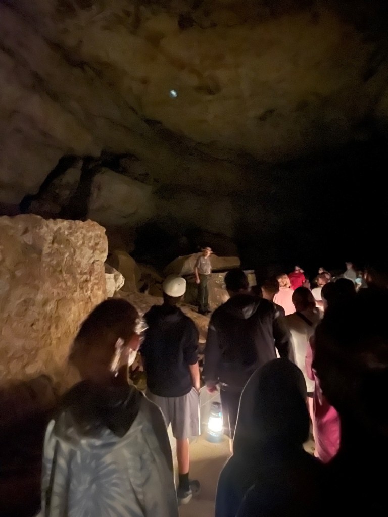
Our guide, National Park Service Ranger Matthew, a retired schoolteacher, welcomes the Star Chamber Tour group to the Historic Entrance of Mammoth Cave. Matthew is a retired schoolteacher. The tour, which started at 6 PM, allowed us to visit the cave as those who entered the cave a hundred years ago did: with oil lanterns. The Star Chamber tour is two miles long and lasted 2 1/2 hours; it was nearly full dark when we emerged from the cave. Ranger Quentin is behind the shrub in the center of the photograph; we talked with him a bit during the tour and he shared that he’d just been informed that he’d been named a full-time NPS ranger. As anyone who has spent time in national parks can imagine, it’s a very competitive position; Quentin is a native of the Cave City area, so it had to be especially rewarding.
Native Americans lived in the area around Mammoth Cave for thousands of years, exploring the cave and using it for mineral extraction. They entered the cave through what is now known as the Historic Entrance, and explored at least 14 miles of the system using only the flame from burning torches for light. Evidence shows that Native Americans stopped using the cave about 2,000 years ago, and the caverns were unknown for more than 200 years.
This is the Historic Entrance to the cave, accessed by a long stairway (the stairs seen at the right of the image above). There are about 30 entrances to the cave system, some of which are just small holes barely large enough to squeeze through.
Local history holds that the first European-American entered the cave in the late 1790s. A young boy named John Houchins was hunting black bear (no longer found in the area) and inadvertently came across the huge hole in the ground that is now the Historic Entrance.
During the War of 1812, the cave’s … significant … deposits of guano (there are 13 known bat species in the park, but not all use the cave) served our nation as a source of saltpeter, a component of gunpowder. Some of the wooden assets used in the guano mining operations are still to be observed in the cave, thanks to its cool and humid environment (54 degrees and 87 percent humidity, all day, every day, all the year round).
The site became a local tourist attraction but, because of the area’s remoteness, didn’t see much out-of-state visitors for many decades until the automobile was developed and popularized. The property was privately owned by different interests through the years, all of which conducted tours of the underground passages, until concern about preserving the caverns’ natural resources resulted in Mammoth Cave National Park being established on July 1, 1941. It is the country’s 26th national park. In its first year as a national park, Mammoth Cave saw about 58,000 visitors; we were two of about 663,000 people to visit the park in 2022.
True to its name, Mammoth Cave is pretty big: in fact, it’s the longest cave system in the world and fully twice as long as the next-longest system. Mammoth Cave is currently mapped to include more than 400 miles of caverns (the entire state of Colorado is 380 miles wide), and the scientists believe that as many as 600 miles of caverns remain to be discovered and mapped. The system has been likened to a bowl of spaghetti, with passages intersecting and moving up and down multiple levels .
Understandably so, flashlights and flash photography were forbidden on the cave tours so the photos I was able to take are terrible because the only light available came from lanterns (on the Star Chamber Tour) or electric lights along the cave passages (on the River Styx Tour). However, some of the photos give a sense of scale to the caverns. Much of the present-day caverns are completely dry – the river water that carved them disappeared quickly into deeper caverns many years ago – so there’s no dripping water to create stalagmites and stalactites, along with other formations familiar to spelunkers. To be honest, although there are some beautiful formations to enjoy, for me most of Mammoth’s impressiveness – and there is plenty of that – comes from its sheer size. Mammoth Cave is big, and it’s dark. I remember a ranger’s tale from the first time we visited the national park: in the mid-1930s, before the park was managed by the NPS, the mummified body of a Native American (who’d lived before Columbus reached the New World and was killed when he was struck by a large falling rock) was discovered on a ledge in one of the caverns. By that time, hundreds of guided tours had passed by the body and all of the people – numbering in the thousands, at least – in all of the tours were unaware that they were passing by the mummy, which was only a few feet above their heads. It was just too big, and too dark, in Mammoth Cave to know about the mummy until someone happened to come across it.
The pandemic limited the number of tours available; some of the tours that Nancy and I went on during our first visit weren’t available at the time of our visit in July (mostly because of a shortage of National Park Service rangers trained to lead the tours). However, we enjoyed the Star Chamber Lanternlight Tour one evening, as well as the daytime River Styx Tour on another day.
The cave’s corridors vary greatly in size: some passages require visitors to walk sideways in order to pass through, and other caverns are wide enough to accommodate a Boeing 747 jet (I didn’t see any aircraft on either tour, but it was pretty dark).
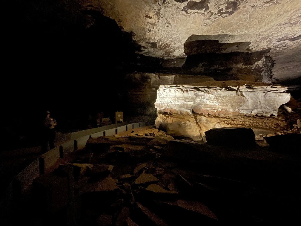
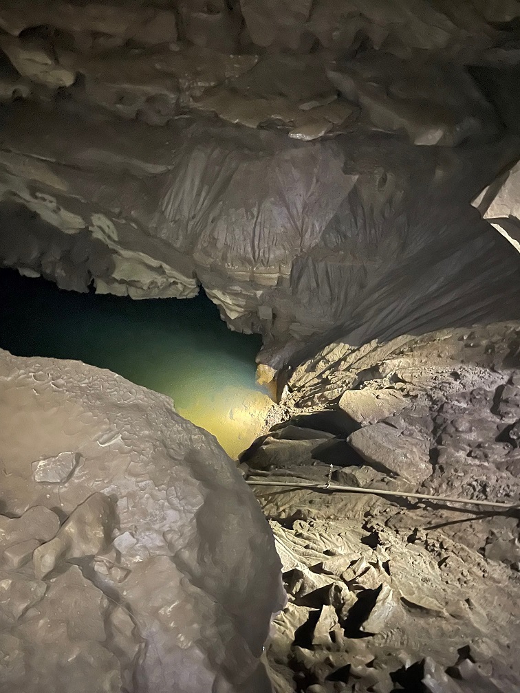
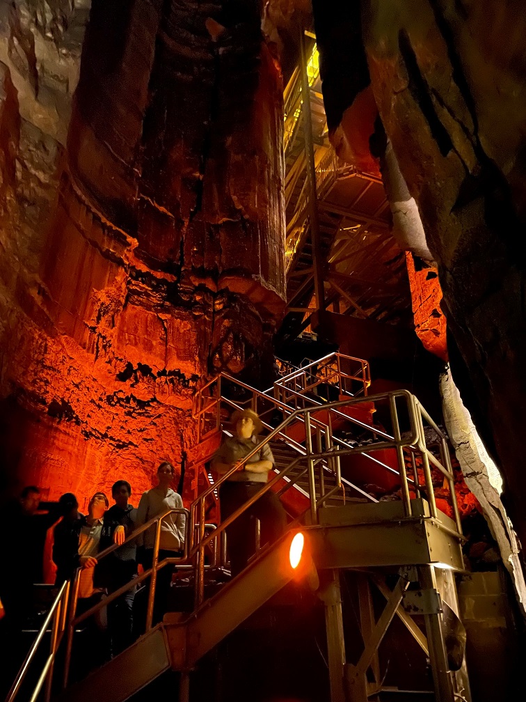
We saw this formation, called the Giant’s Coffin, on both of our tours (which shared a bit of the same trail). Located 175 feet below the surface, the Giant’s Coffin is a limestone nugget measuring nearly 50 feet long and 20 feet tall, and weighing a thousand tons. The rock separated from the limestone wall behind it sometime in the distant past; imagine the sound it made when it fell. Our NPS ranger guide is in the shadows at the left of the photo; if I remember right, she’s standing perhaps 50 feet in front of the Giant’s Coffin.At one point on the Star Chamber Tour, Ranger Matthew asked us to place our oil lanterns in a row on the cave floor. He and Ranger Quentin then extinguished all of the lamps and used a flashlight to guide their way behind a rock wall, leaving us in total darkness (he’d mentioned they’d do this beforehand; they didn’t just sneak off and leave us). If you’ve never been in a completely darkened cave, you’ve never known true darkness: the absence of all light. Even being outside on a moonless night, well removed from city lights, isn’t the same because there’s still starlight to provide some illumination, however feeble. It’s a common occurrence on cave tours, this extinguishing of all artificial light, but it never fails to strike some primeval chord – to not be able to see your hand in an inch in front of your face, let alone across the room. It also gives one a better appreciation for those early explorers: modern spelunkers carry all sorts of redundant sources of light – there are only so many torches or lanterns one can carry.This picture is from the River Styx tour, which was illuminated by electric lighting for most of the 2 1/2-mile trail. The tour includes a visit to the River Styx, an underground tributary of the Green River, but flooding in the cave in 2010 destroyed the electrical system along that part of the tour. We needed battery-powered lanterns to continue. (Incidentally, as of this writing in August 2023, the River Styx tour isn’t being offered – I wonder if the electrical system is being repaired.) Notice the scallop-shaped carvings in the rock ceiling above: those indicate the direction and velocity of the flow of water eroding the rock. Larger scalloped features (a meter or more wide) mean that the water was moving only a few centimeters per second, and smaller scallops indicate that the water was flowing in meters per second.This is a pool known as the Dead Sea, created by the Green River. It’s about 15 feet below the point at which this picture was taken. Artificial lighting next to the river shows some details of the water erosion. The occasional blind cave fish or blind crayfish can be observed in these waters; alas, they were not to be observed on this occasion.And here is the River Styx, which looks a lot like the previous photo of the Dead Sea. Bur remember, friends, that the River Styx is but a tributary of the Dead Sea’s Green River.Here was another highlight of the River Styx Tour: seeing the incredible Mammoth Dome. Known in spelunking terms as a “vertical shaft,” Mammoth Dome was created when water followed the law of gravity to flow straight down vertical crevices in the limestone. The erosional activity results in shafts that, at Mammoth Cave, measure 30 feet or more. In Mammoth Dome’s case, that resulted in a vertical shaft measuring 190 feet in height. An impressive metal staircase provided a lot of viewpoints to see the dome (there’s still a lot of climbing to do; see the top of the staircase at the top of the photo).
River Styx Spring Trail
While there are a number of different tours available for anyone wanting to explore the bowels of the earth at Mammoth Cave National Park, it also features more than 80 miles of above-ground trails. Gunther joined Nancy and me for a hike on the River Styx Spring trail, which provided for some great views of the Kentucky countryside.
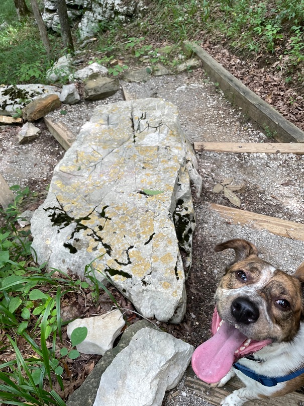
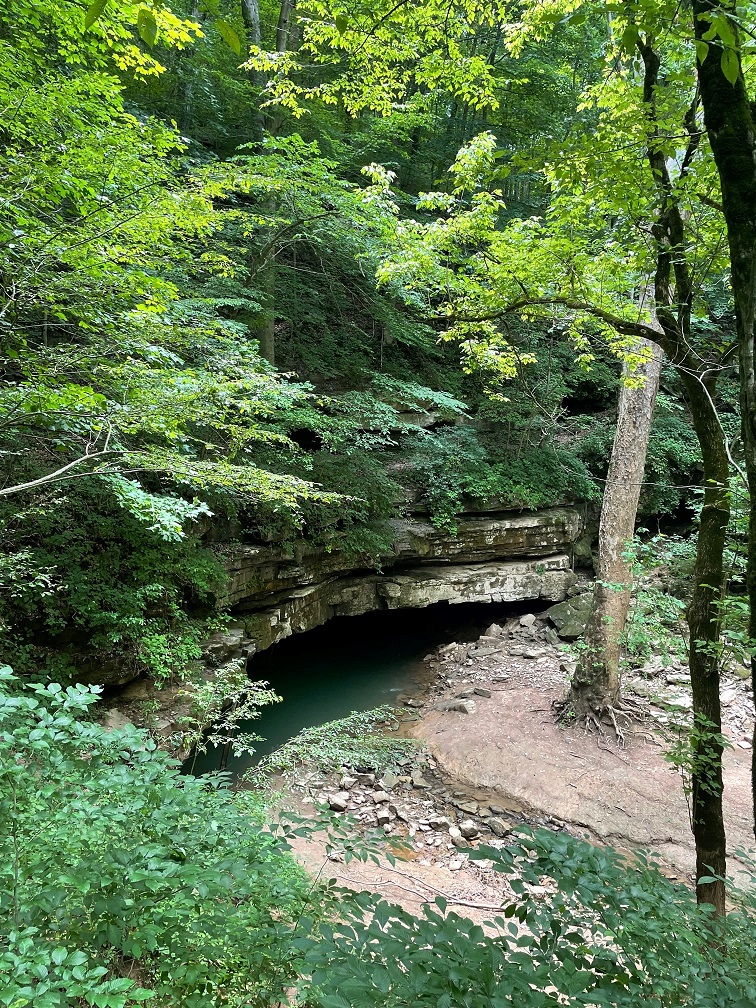
Because we spent most of our lives in Colorado, neither Nancy nor I are familiar with vistas like this: hardwood forests as far as the eye can see. Mammoth Cave National Park currently encompasses 53,000 acres, or about 80 square miles; while it’s justifiably most famous for its subterranean caverns, there are plenty of opportunities for above-ground adventures.We encountered this whitetail fawn near the trailhead of the River Styx Spring trail. Its mom was less than 10 feet away. It must be pretty used to seeing humans; I don’t think I’ve knowingly ever been this close to a young fawn before. The speckled pattern on a very young deer’s sides act as a kind of camouflage, helping it to blend in with the sun-dappled undergrowth in forests. I would think that fawns would also be predominantly grass-green instead of brown, but I suppose evolution knows what it’s doing.The River Styx Spring Trail passes by a historic cemetery that is the final resting place of Stephen Bishop, one of the first non-Native-American explorers of the cave system. Bishop’s story is very interesting: in 1839, the Mammoth Cave estate, along with several Black slaves including Bishop, were sold to Dr. John Croghan for the amount of $10,000 (about $275,000 today). Croghan began to explore making improvements to the property’s tourism assets, like the hotel, and Bishop began to explore the underground caverns. A gifted spelunker and popular guide, Bishop also named many features within the cave – including the River Styx. In 1844, he published a detailed map of the cave system; the map would remain the primary guide to the cave for 40 years. The map contained about 10 miles of passages within Mammoth Cave, half of which Bishop discovered himself. Croghan envisioned using part of the interior of the cave as a tuberculosis treatment facility – some of the stone housing built for tuberculosis patients in 1841 is still standing along present-day tours of the cave – thinking that the cave’s environment would provide helpful results, but the treatment failed. In fact, all 10 of the tuberculosis patients either died in the cave or later after they exited the cavern. Further, the widespread disease would claim the lives of both Croghan and Bishop: Croghan died in 1849, and had stipulated in his will that Bishop would be declared a free man seven years after Croghan’s death. Bishop did enjoy a few months of freedom beginning in 1856, but tuberculosis claimed his life in the summer of 1857. He was buried on the Mammoth Cave grounds but his grave remained marked only by a cedar tree until 1881, when a second-hand tombstone (it was originally intended for a Civil War veteran’s grave but the family never claimed it – explaining the appearance of a sword and flag on the headstone) was inscribed and placed at Bishop’s gravesite. The date of his death is incorrect on the headstone.Look at this rock Gunther found on the hike! Look at it! In addition to seemingly endless hardwood forest vistas, neither Nancy nor me nor Gunther were used to the high temperatures combined with the high humidity of central Kentucky in July. This part of central Kentucky gets about 50 inches of rain each year.Here is the terminus of the River Styx Spring hike: a view of the water feature we’d seen only underground. Presumably any fish or crayfish in this part of the river have the gift of sight.
A couple of birds
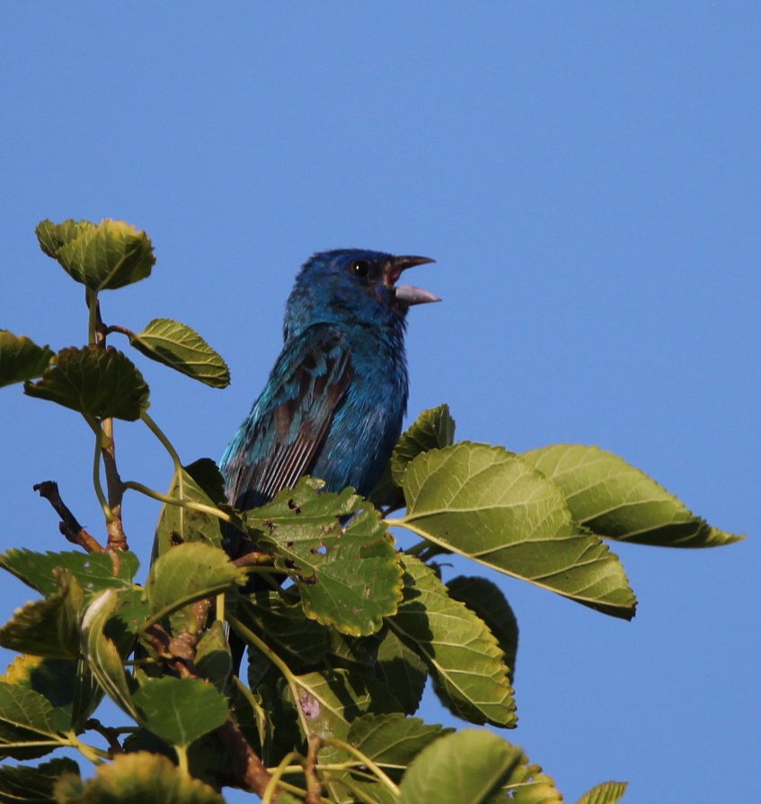
I’ll close with a couple of bird photos from our campground in Cave City, which is a little more than 10 miles from the Mammoth Cave National Park visitor center. This is, of course, an American robin (Turdus migratorius) that lit upon one of our campground’s picnic tables. They’re common birds but always fun to watch. They’re found throughout the United States but breed in Canada.Here was a new bird to me: an indigo bunting (Passerina cyanea). They’re found in the eastern United States and the southern part of the country. The scientists discovered that indigo buntings, which, like many other species migrate at night, and navigate using the stars. The experiment involved placing some of the birds in a planetarium. The birds adjusted their orientation in the room as the projected stars above changed position. Their remarkable blue color is due to microscopic structures in their feathers that reflect and refract blue light – very similarly to why the sky above the bunting looks blue.
There are a number of NPS sites that prominently feature caves including a couple, perhaps improbably, in South Dakota, which we visited a number of years ago (did I mention that Nancy likes caves?) However, none are bigger than Mammoth Cave in Kentucky, and, thanks to the Green River, it’s getting bigger every day.
Thank goodness we were done with caves for the year.*