When I was a boy, growing up in the town of Flagler (population: around 600 in the 1980s) in eastern Colorado, there wasn’t much to do in one’s free time but I never got bored.
Flagler was very fortunate to have a movie theater that presented movies on weekend nights, except on those weekend nights when the Flagler Panthers hosted high school football, basketball, and volleyball games since everyone went to those instead of “the Show,” as we called it. That theater, still in operation and sporting a new digital projector and new seating, was where I first saw movies like “Raiders of the Lost Ark” (1981) and “E.T. the Extraterrestrial” (1982), instilling in me a deep and lifelong appreciation of the movies.
For more entertainment, there was a reservoir a few miles east of town that was so full when we first moved to Flagler in 1979 that the lake was overflowing its impoundment dam. It was a favorite destination for eastern Colorado anglers and waterskiers – unthinkable now because, due to agricultural demands for water downstream, the reservoir has been no more than a muddy drainage of the Republican River for many, many years.
I remember my high school chums and I, perhaps after the Show, cruising the six blocks of Flagler’s Main Street in our vehicles on weekend nights by putting the transmission in “D” and taking our foot off the brake. It provided some good times, at three miles an hour.
Much of the lack of boredom of my childhood is due to the many other pastimes available in eastern Colorado: museums, other movie theaters, and attractions like the World’s Wonder View Tower.
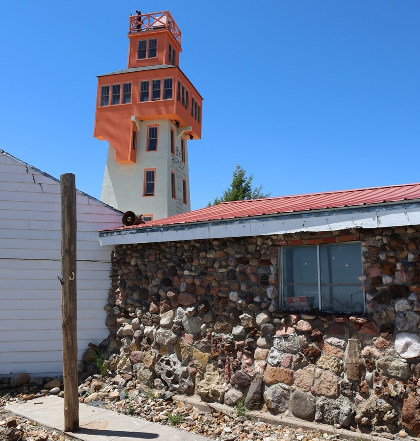
The rock building in the foreground is the museum part of the World’s Wonder View Tower, with the namesake attraction just behind on the left. When I was a boy, the entrance to the museum and the tower was a door just to the right of the window in front. Note the wide variety of rocks used in the building’s construction. Note also a person at the top of the tower; I was to later discover that was either my old Flagler high school chum Gary Beedy, or Gary’s brother, Steve. The Beedy brothers, fourth-generation Genoa-area farmers, are strong supporters of the World’s Wonder View Tower’s restoration and happened to be at the tower the same day we were, and we were pleasantly surprised to see them in the tower’s entrance a few minutes after I took this photo. Eastern Colorado comprises about 40,000 square miles (making it about the size of the entire state of Kentucky), but it can sometimes be a mighty small place.
Located 25 miles west of Flagler in Genoa, Colorado (population in the 2020 U.S. Census: 153), the complex that includes the World’s Wonder View Tower was built in 1926 by Charles Gregory and his partner, Myrtle LeBow. Genoa itself was named after the sixth-largest city in Italy and was located near a natural spring that had attracted wildlife, Native Americans, and Anglo-American explorers to this high spot on the arid plains. Gregory had camped in the area in his younger days, and returned to Genoa to build a top-flight tourist attraction that happened to be right next to a new United States highway.
The decade of the 1920s saw huge growth in the popularity of seeing the United States by automobile, which was further aided by the development of the U.S. Numbered Highway System in 1926. Gregory and LeBow originally built a roadside stop at this location that included a gas station, café, and stage for entertainment. The couple later expanded the amenities to include guest rooms and the 65-foot-tall tower structure.
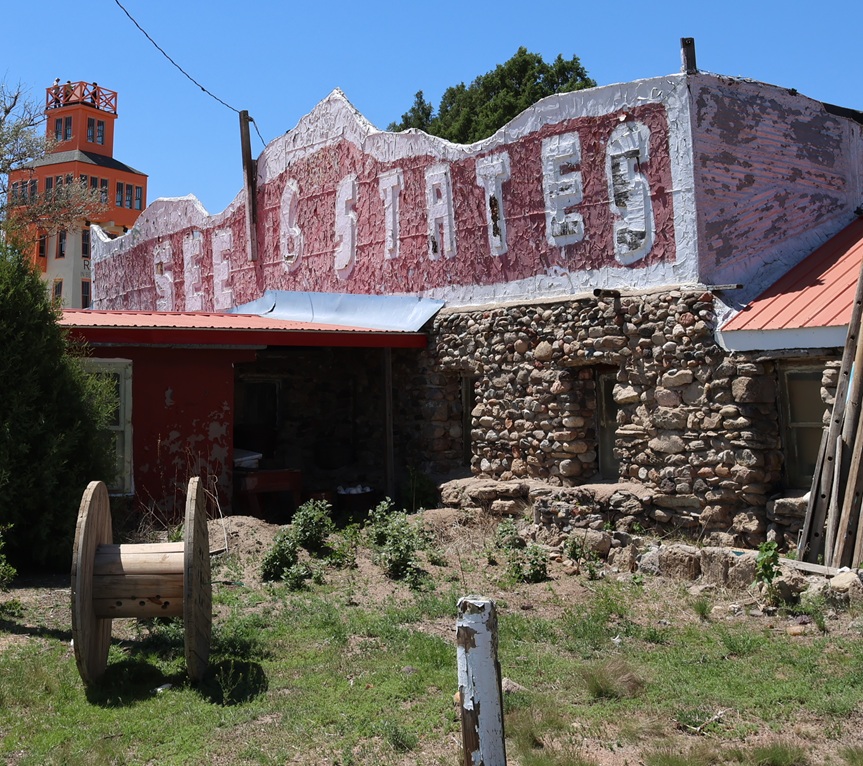
This faded façade is one of my lasting memories of visiting the World’s Wonder View Tower (we just called it “the Genoa Tower,” and no one seemed confused about what we were discussing). The current stewarding organization of the tower complex has focused its efforts on restoring the World’s Wonder View Tower itself, and rightly so.
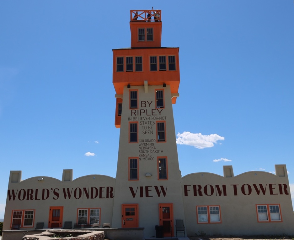
When completed, the World’s Wonder View Tower, which begins at Genoa’s elevation of 5,604 feet (1,708 m) was the highest point between the Palmer Divide of the Rocky Mountains to the west and the mountains of the eastern United States. The tremendous height of the tower affords simply spectacular views in all directions of the compass.
In 1933, no less an authority than Ripley’s Believe It Or Not confirmed that six states – Kansas, Wyoming, South Dakota, Nebraska, New Mexico, and, of course, Colorado – could be seen from the top of the 65 tower. Our tour guide on our June 2026 visit, who accompanied our group to the top, used the word “technically” fairly often when she spoke about the opportunity to see a half-dozen states, such as “Technically, you can see South Dakota.” I finally said “You’re throwing the word ‘technically’ around quite a lot …” and she responded with the expected (and I’m paraphrasing), “We just don’t want to wind up in litigation.” Completely fair, I think.
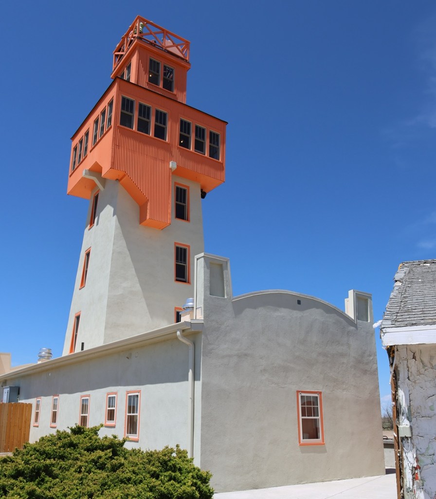
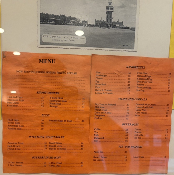
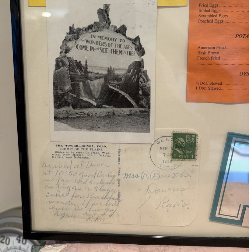
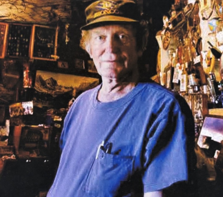
This picture was taken from the east side of the World’s Wonder View Tower. The tower’s original entrance was here on the east side because U.S. Highway 40N (which would be redesignated U.S. Highway 24 in 1936) passed by the tower a few yards to the north. In the 1970s, with the development of Interstate 70 south of the tower, the attraction’s entrance was moved to the south side for easier accessibility. When restoring the tower, the entrance was re-located back to this side of the building. I believe that’s Gary and Steve Beedy still at the top of the tower; I don’t know if they could see the six states of Colorado, Wyoming, Nebraska, South Dakota, Kansas, and New Mexico, but they could almost certainly see their farm located a few miles north of Genoa. Gary and Steve’s great-grandparents first homesteaded the farm in 1893, 33 years before Gregory and LeBow began building this attraction.Here’s a look at the 65-foot-tall World’s Wonder View Tower from its southwest corner. Jerry Chubbuck built an apartment for his family that connected the building on the left with the one on the right; See Six States LLC restored the two buildings to their original and individual states. The new paint job, based on historic photos of the buildings, looks fantastic.In a frame and behind glass inside the tower’s entrance, here are a postcard (“THE TOWER – – Genoa, Colo. Summit of the Plains”) and a menu from when the tower had a café. Nancy and I both wondered about the provenance of OYSTERS IN SEASON. I wouldn’t pass up a piece of apple pie, though, especially at 10 cents.To the lower left of the menu, here are a couple more historic postcards. The bottom one, which has a Genoa (Colorado, not the capital of Liguria in Italy) postmark of April 7, 1950, is addressed to Mrs. R. Bowers of Downs, Kansas (located in the north-central part of the Sunflower State), and reads: “Arrived at tower at 10:50. Good luck so far. Had a stack” (presumably of pancakes, although they’re not on the menu pictured above) “as big as a 5-layer cake for breakfast, wonder if we could ever be hungry again.”This is a picture of a picture at the tower’s entrance of Jerry Chubbuck (October 22, 1930 – August 4, 2013), who owned the World’s Wonder View Tower from 1967 until he passed away. Jerry, who was born in Arriba, Colorado, about 13 miles east of Genoa, was a fascinating person with wide-ranging interests in archeology, geology, paleontology, Native American cultures, and more. He converted the tower’s overnight guest rooms, café, and other rooms into a winding museum that was sort of overwhelming in its scope. It contained exhibits of thousands of arrowheads, dozens of telegraph and telephone line insulators, mammoth fossils (that he discovered), a taxidermied two-headed calf, World War I and World War II-era military memorabilia, petrified wood samples and other rock collections that went on forever, old and obscure farm and ranch tools and machinery, and much more. Jerry had stories about nearly everything under the museum’s roof, and I have fond memories of Jerry greeting visitors at the front door, collecting one dollar in admission, and then offering to refund their dollar if they could guess what historic artifact (usually some sort of old and obscure farm tool or implement) he happened to be holding in his hand. I’m here to tell you: there were some weird and specialized things manufactured in the old days, and I never, despite Jerry’s patience and hints, got my dollar back from any of my visits. Under Jerry’s stewardship of the Genoa Tower, it became a pretty famous landmark along Interstate 70. My other lasting memory of Jerry, who obviously loved sharing his knowledge with others: after telling you what some artifact was and how to use it, he’d end his sentences with, “Yep. Uh-huh. R-i-i-i-ght.” I think the world needs more people like Jerry Chubbuck.
Jerry passed away in 2013, and the site fell into disuse for several years until some Colorado history aficionados, determined to save the property from fading from the map, formed a limited liability corporation (enigmatically called “See Six States LLC”) to acquire the tower and surrounding buildings and land. See Six States LLC put the property in the hands of a nonprofit group called Friends of the Genoa Tower, the board members of which include Patricia Calhoun, who co-founded the Denver alternative weekly newspaper Westword in 1977 and was, until her pending retirement in the summer of 2026, the newspaper’s editor-in-chief. Troy McCue, another high-school chum of mine, is also a member of the Friends of the Genoa Tower board; he’s now the executive director of Lincoln County Economic Development, which promotes and maintains job creation and business growth in this eastern Colorado county in which Genoa is located.
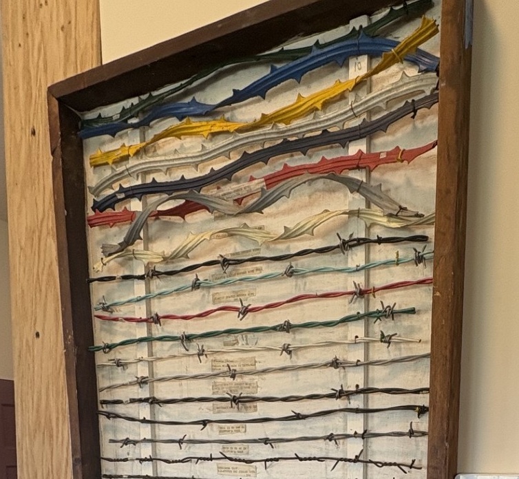
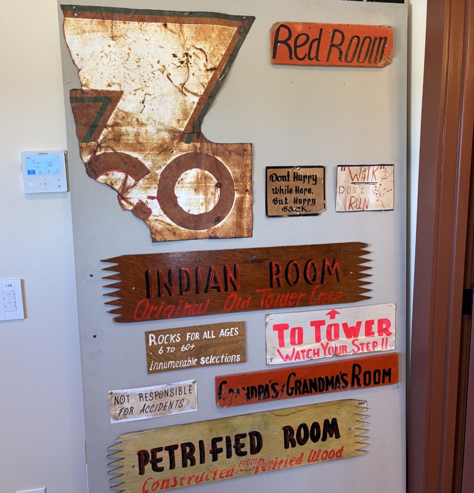
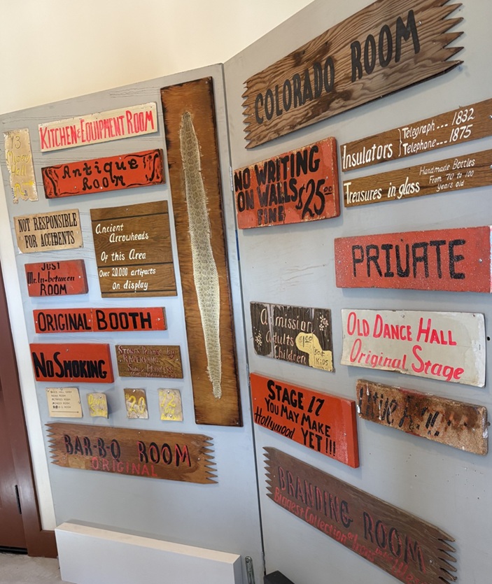
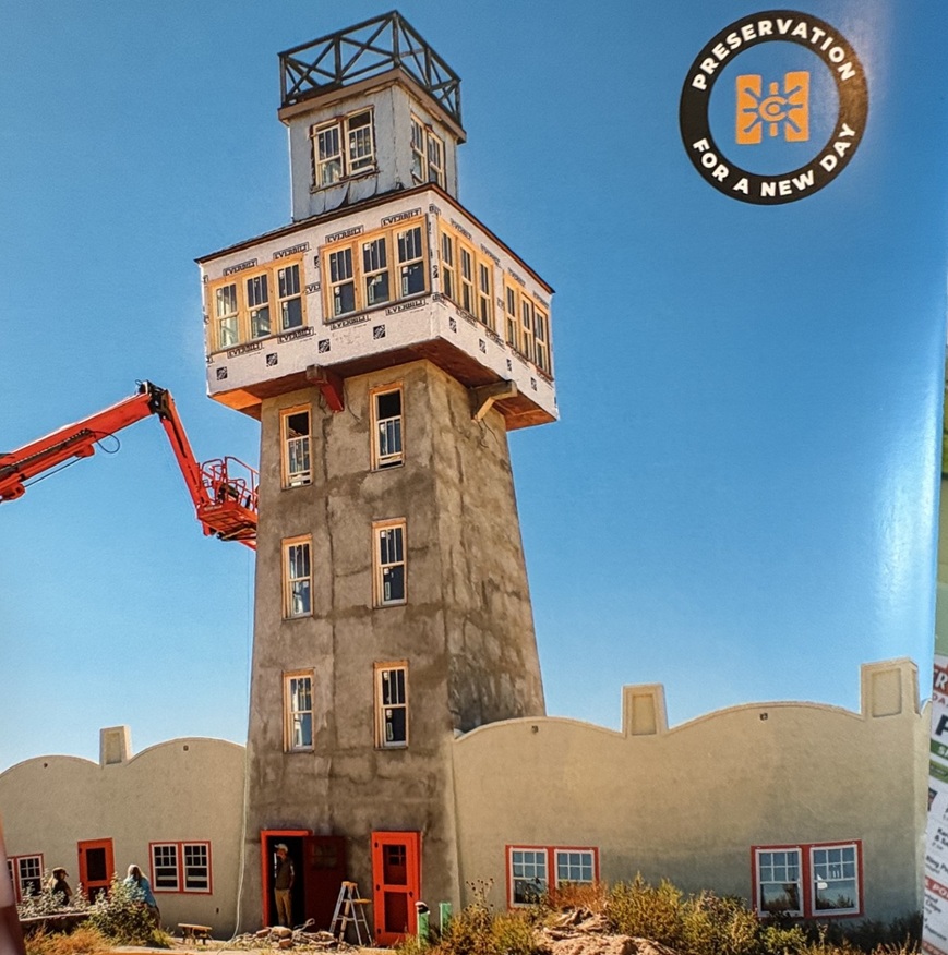
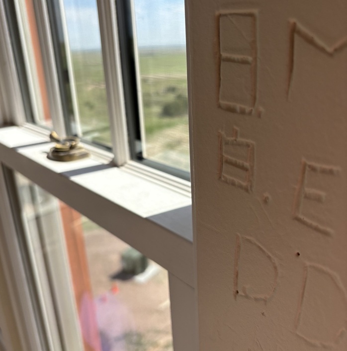
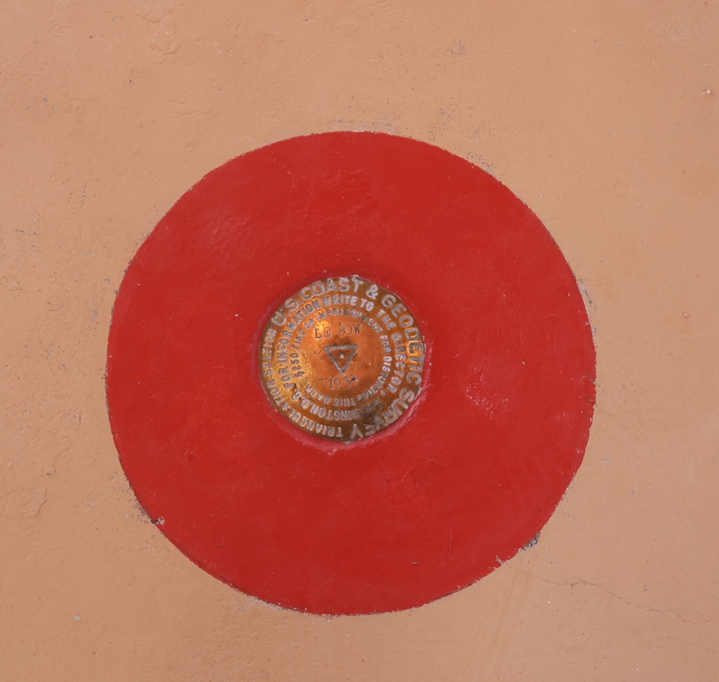
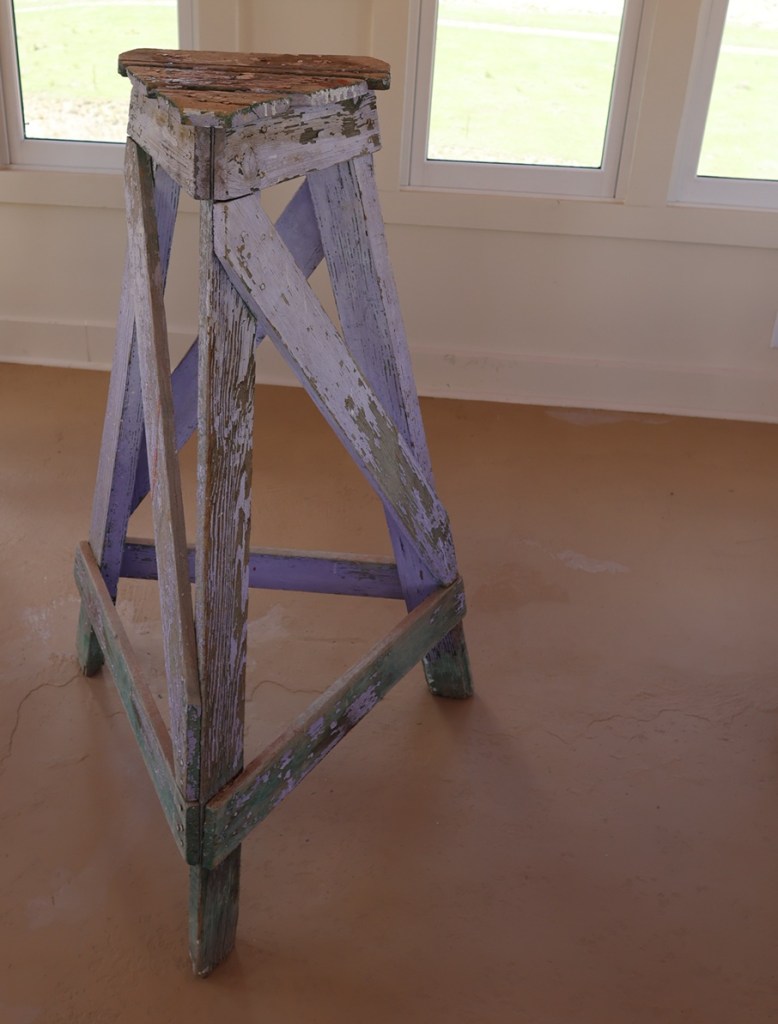
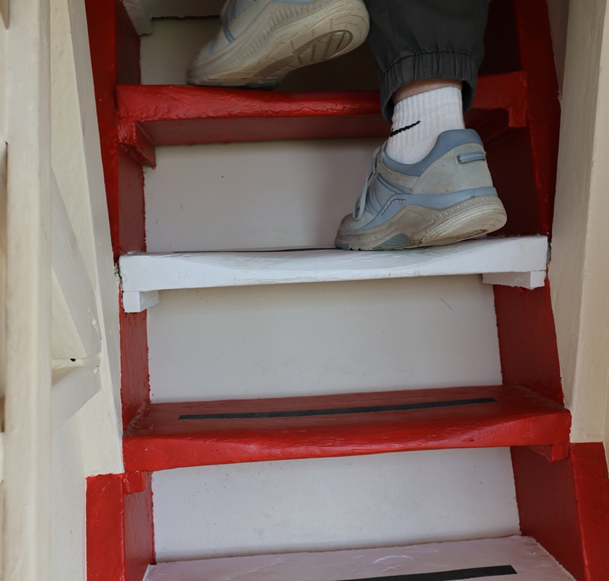
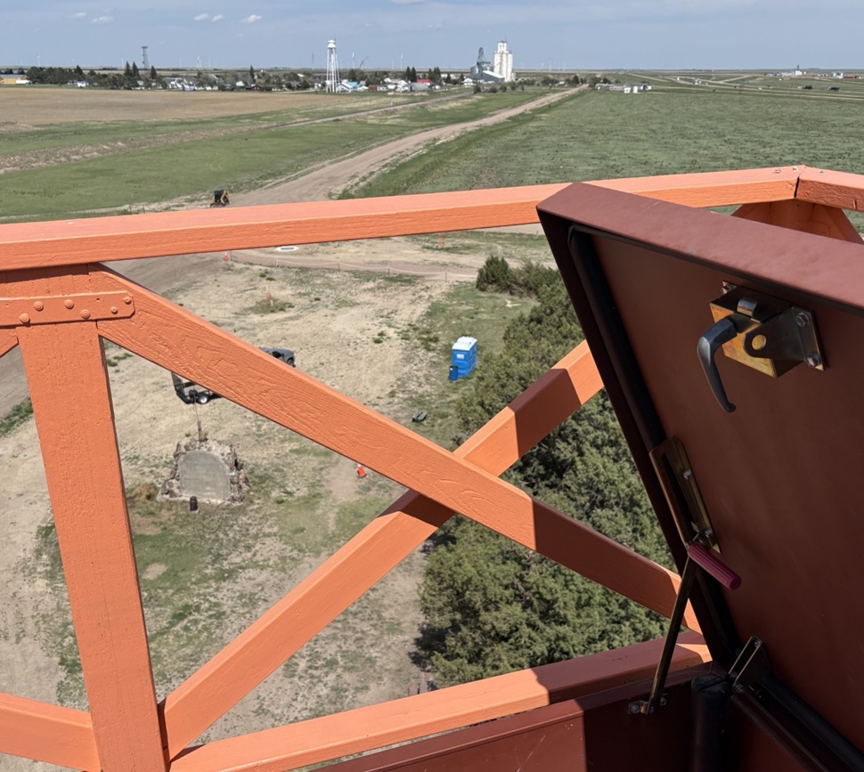
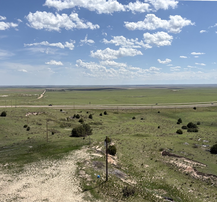
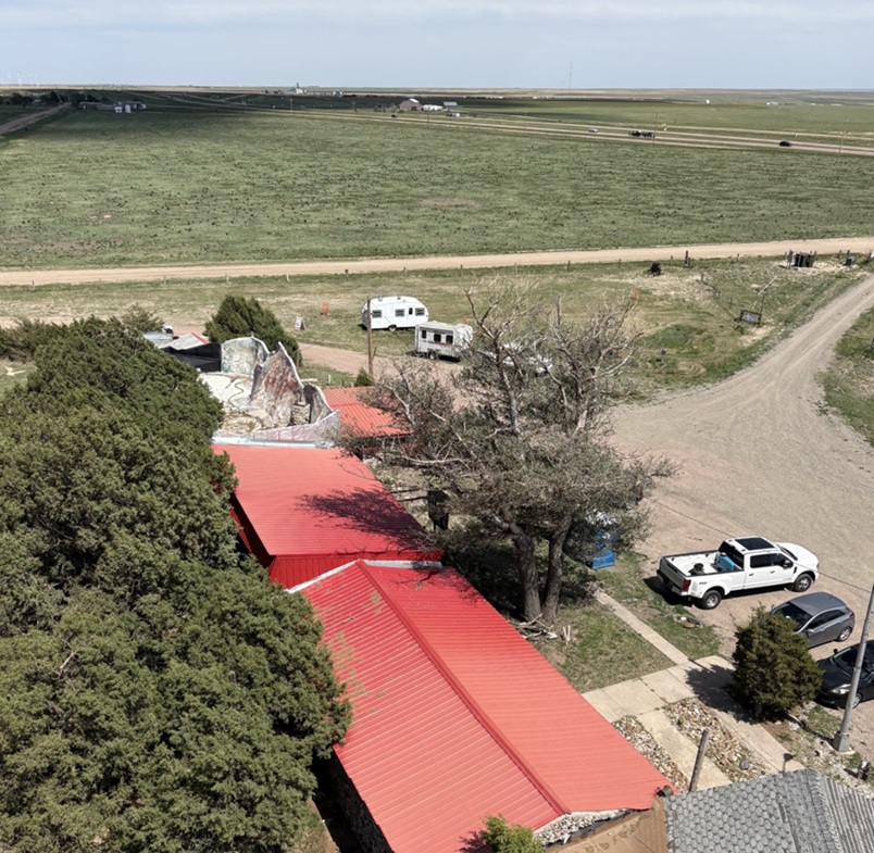
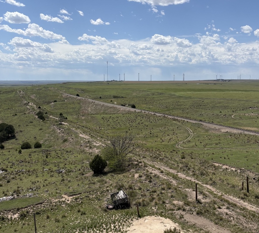
Much of Jerry’s museum collection was sold at public auction, so the two-headed calf and fossilized mammoth bones and most of the other items have found new homes all around the world (although word on the street is that there is an effort to retrieve some of the curiosities, but you didn’t hear that from me). One item that thankfully didn’t get spread to the four winds is this fine display of barbed wire, exhibited in the tower’s gift shop. Regular readers of this blog will know that I will spare no effort to post pictures of any worthy museum’s barbed wire exhibits and I’m rather unapologetic about it, so here you go.Fortunately, some of Jerry Chubbuck’s hand-painted museum signage, much of which identified the attraction’s many different rooms and warrens, was also withheld from the public auction and is now on display in the tower’s gift shop. I remember seeing some of these signs 40 years ago, and it was good to see them again.There were a lot of museum rooms (I want to say there were at least 20, but my memory may be faulty and it might have been more than that), and they all needed to be identified with signs. The sign at lower right, “Branding Room,” identified the room as containing the “Biggest Collection of Irons in the West.” I have no doubt that it was. Also of note: the signs announcing more than 20,000 “ancient arrowheads of this area” on display and “No Writing on Walls; Fine: $25.”This is a picture of a cover of one of History Colorado State Historical Fund’s annual reports, showing progress of the World’s Wonder View Tower restoration. The project, heavily financed by grants from the state’s historical fund but also with significant contributions from other donors from all around the state and local area, needed more than $3 million in funds for completion. See 6 States LLC and Friends of The Genoa Tower have some really exciting plans for the property, including its usage as an art gallery space and a venue for event functions. The property celebrated its grand reopening in early May of this year. From the standpoint of someone who visited it back in the day and then again this spring, it’s a very impressive transformation that has some great possibilities in front of it.Despite the threat of a $25 fine, many miscreants decided to leave graffiti on the tower’s walls as they ascended to the top. See 6 States LLC, in restoring the tower, made the right choice to leave the graffiti in situ while putting another coat of paint on the walls. This photo was taken from one of the tower’s staircases, looking southwest through a historic window.The United States Coast & Geodetic Survey placed this geodetic marker in the floor of one of the tower’s upper rooms in the 1930s, confirming the latitude, longitude, and, most importantly, the elevation of the World’s Wonder View Tower. Note the name “LeBow” (as in Myrtle) and the year, 1934, in the center of the disk. The USC&GS existed from 1807 until 1970, when it and several other government agencies became part of the National Oceanic and Atmospheric Administration (NOAA). People who hike a lot may have seen these markers on trails, used to compile accurate survey information with exact latitudinal, longitudinal, and elevation points on the surface of the Earth. This was the first one I’d seen that was about 50 feet off the surface of the Earth.The government surveyors used this wooden tripod, which they assembled in the tower room containing the geodetic marker, to precisely place the metal disk in the floor of the tower room in 1934. After the project’s completion, they attempted to take the tripod back down the tower’s stairs, only to find that the tripod’s legs were too wide to be transported down the narrow staircases. So, here it has stood for nearly a century, getting a new coat of paint every now and then.When I was a boy, the staircases in the tower, especially this final one leading to the viewing platform at the very top, could charitably be called “rickety.” See Six States LLC reinforced all of the staircases during the redevelopment, and the climb to the top and the viewing platform are rock-steady now. Happily, the group elected to keep the time-worn steps themselves; one wonders how many shoes have been on these steps in the last near-century. Those are Nancy’s shoes at the top of the photo; she and I had been at the top of the tower together a short time after we met when the Genoa Tower was still under the stewardship of Jerry Chubbuck, so she’s a seasoned veteran of the climb. Are you ready to discover what being at the top of the World’s Wonder View Tower looks like? Just follow Nancy!Taken from the top of the World’s Wonder View Tower, this viewpoint looking east-northeast shows the town of Genoa and then (“technically”) the states of Kansas and Nebraska beyond. Genoa’s water tower and grain elevator, both of which are predated by, and taller than, the World’s Wonder View Tower but you probably aren’t allowed to climb to the their respective tops, can be seen in center-right. You’d think that Genoa, Colorado, would be pronounced the same as the city in Italy (“JEN-oh-uh”). You’d be wrong: it’s pronounced “jen-OH-uh.” Now you know and can impress your friends with your newly acquired worldly knowledge, which, come to think of it, I probably should have shared before nearing the end of this posting.This perspective from the top of the World’s Wonder View Tower is looking directly south. On the other side of the cedar trees is Interstate 70, then about 20,000 square miles of Colorado farm- and ranchland, then (“technically”) New Mexico. It was a little hazy on the day of our visit, but the views were still really spectacular.This is a view from the top of the tower looking to the southeast. That’s again Interstate 70 near the horizon and (“technically”) Kansas beyond. Being 65 feet above the ground gives an interesting perspective to your surroundings, such as seeing some parts of the landscape under the darkness of cloud cover. The red roofs are the historic buildings of the World’s Wonder View Tower, where the café and overnight guest rooms, and later Jerry Chubbuck’s museum, were located. Just above them is the back side of the white-and-red “See 6 States” façade shown earlier. The white Ford F-350 Super Duty is Ol’ Blue, the Goddard’s six-wheeled towing unit. Just visible above the tree to the left of Ol’ Blue is a small travel trailer. That’s our first camping trailer, the predecessor to The Goddard, which we called “The Riglet” because bigger camping trailers and motor homes are sometimes called “rigs.” The Riglet is now owned by our friends Mary and Robert, whose company we enjoyed at the World’s Wonder View Tower and then they joined us in the Arriba campground in which we were staying for more fellowship.One last view from the top of the tower: this is looking northwest, so Denver is presumably somewhere on the horizon. There’s a radio tower on the horizon just left of center and most of the rest of the tall structures are wind turbines. The dependable winds available in eastern Colorado are quickly making the area an important location for renewable energy generation. The railroad bed and rails, still in use today, can be seen in the center of the picture, and just to the right of the tree in lower center is a dirt road that is the remnant of the old U.S. Highway 24 which, until the completion of Interstate 70 in the 1970s, brought people by the tens of thousands to the World’s Wonder View Tower. Goodbye until we see each other again, World’s Wonder View Tower! I look forward to seeing what your next hundred years will bring.
September 28, 2024 – Near Pagosa Springs, Colorado
At the entrance to Chimney Rock National Monument, one can see Chimney Rock (center horizon), Companion Rock (to the left of Chimney Rock), and the mesa on which an ancient Puebloan great house still stands (at far left).
The scientific pursuits of geology, archeology, and astronomy combine in a number of interesting ways at Chimney Rock National Monument, located about 20 miles of Pagosa Springs in southwestern Colorado. In late September 2024, the Goddard was parked for a couple of weeks in Pagosa Springs, allowing us to enjoy the spectacular fall colors of aspen trees as well as a visit to Chimney Rock National Monument. We joined a geology-focused tour of the monument led by a volunteer guide, a former geologist in the oil and gas industry. In addition to learning about the rock features of the monument, we also learned about the history of the human habitation of Chimney Rock and visited the highest-in-elevation ancient Pueblo in the American Southwest, the Great House.
I took this photo from the road entrance to Chimney Rock National Monument using a telephoto lens. For perspective, Chimney Rock on the right rises more than 300 feet above the dark gray shale layer below it.
Between the years 925 and 1125, more than 2,000 Pueblo Native Americans lived in the Chimney Rock region and, although no more than about 250 people called it home at one time, they made it a substantial settlement for two centuries. The inhabitants built a number of stone and timber structures that are still standing today, and they traded goods with other Pueblo communities up to 150 miles away. Today, archaeologists know of 200 ancient structures collected within eight distinct villages at Chimney Rock.
Initial archeological investigations began in the 1920s by J.A. Jeançon, a Smithsonian Institution-trained archeologist working on behalf of the Colorado Historical Society, and his assistant, Frank Roberts; they and their crew surveyed and mapped dozens of structures and found thousands of artifacts.
Today, the U.S. Forest Service, which manages Chimney Rock National Monument, is leaving many archeological sites undisturbed out of respect for existing Puebloan and other Native American cultures, and with the understanding that less-invasive archeological techniques may be developed in the future. More than two dozen Native American tribes have an affiliation with Chimney Rock.
The monument, surrounded by the Southern Ute Indian Reservation, is closed to the general public each year from September 30 to May 15. The closure allows Native Americans to access the site for private ceremonial purposes, and the Chimney Rock area is also a major thoroughfare for elk migration.
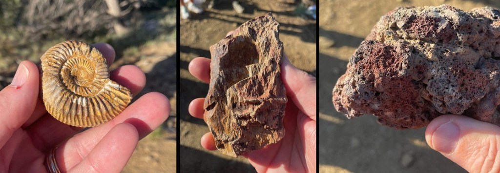
Geology! These three rocks, all of which were collected earlier at Chimney Rock by the volunteer geologist conducting our tour, tell a really interesting part of the story of the area. The ammonite fossil at far left shows that Chimney Rock, which today gets about 14 inches of precipitation annually, was once covered by an inland sea. Ammonites were incredibly diverse and numerous aquatic cephalopods (related to modern squid and octopi) that flourished for hundreds of millions of years until the Earth’s collision with an asteroid 65 million years ago. The petrified wood in the center indicates that large trees used to grow on shorelines left when the land rose and the sea receded. Finally, the basalt at right was ejected from an erupting volcano in the area. (Yes, I know the ammonite photo also demonstrates that I was, at the time, in gruesomely desperate need of my semi-annual mani-pedi.)
The true importance of Chimney Rock lies, of course, in its ties to ancient and current-day Native Americans. But from a geologic perspective, the story of Chimney Rock begins, seemingly as do so many on this website, with a great inland sea. One hundred million years ago, much of present-day North America was under a shallow but vast sea that connected the Gulf of Mexico to the Arctic Ocean. At its largest size, the Western Interior Seaway stretched from today’s Rocky Mountains in the west to the Appalachian range in the east. At its deepest points, it was only about 3,000 feet from the waves on top to the sea bottom – very shallow for a sea. The size of the sea varied widely over the course of its 34 million years of existence; it finally drained away for good about the time of the end of the Cretaceous Period, or 65 million years ago when dinosaurs ceased to rule the earth.
While it was relatively shallow, the Western Interior Seaway’s 3,000 feet of water depth carried a lot of compression capability. Clay at the bottom of the sea, as well as dead plants and animals, accumulated over the eons to build a 1,000-feet-thick layer of mud. That layer would solidify, over millions of years of water weight pressing upon it, into a dark gray layer of rock called Lewis Shale. When the western part of the American continent began to rise, the waters of the inland sea drained away to leave shorelines of sand and tidal flats. Dry periods alternated with years upon years of wetter conditions, leaving layers of coal and fossilized animal skeletons.
About 40 million years ago – 26 million years after an asteroid impact killed all of the non-flying dinosaurs as well as a goodly amount of other life on Earth – volcanoes began erupting in the Four Corners area of Colorado, Utah, New Mexico, and Arizona. This activity built the Colorado Plateau, a huge high-desert expanse of the southwestern United States covering 130,000 square miles of those four states, roughly centered in the Four Corners area.
The erosional forces of wind and water began to have their way with the soil covering today’s Companion Rock and Chimney Rock, and then glaciers from the last Ice Age of 4 million years ago carved deeply into the former mud of the inland seafloor, now compressed into shale. Finally, the glaciers melted and the resulting floodwaters exposed sandstone – formerly the beaches of the receding inland sea from tens of millions of years earlier but compressed into a rocky layer – and eroded away nearly all of that sandstone layer with the exception of Companion Rock and Chimney Rock. The scientists believe that the two sandstone features have been exposed for about 25,000 years, protected by what was probably the thickest and hardest layer of sand during the time of the Western Interior Seaway and is now a layer of sandstone more resistant to erosion than other rocks had been. However, they too, with the relentless work of water and wind, will gradually fall to the valley below.
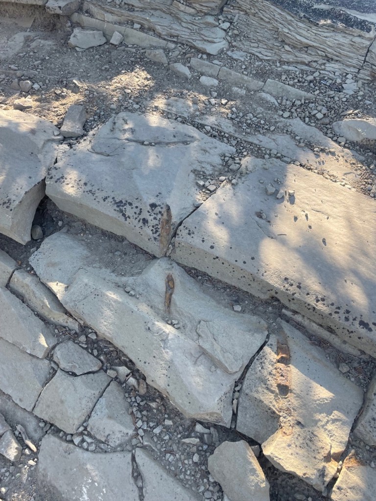
This view, looking east on a hazy late-September morning, shows the dark-gray Lewis Shale layer below the light-brown Pictured Cliffs Sandstone layer, of which Companion Rock and Chimney Rock are the tallest remnants. This valley was carved by glaciers and the flooding of the melted glaciers as well as the Piedra River. To the immediate left of the two natural rock towers is the Great House, built by ancient Puebloans . The San Juan mountains, volcanic in origin, are on the far horizon.This is the trail leading to the monument’s Great House, one of the square exterior corners of which can be seen at the top of the photo. This is the same trail that was used by the ancient Puebloans to make their way from the valley floor to the Great House. The trail is situated on a relatively thin ridge of sandstone. Everything brought to the Great House – building materials, foodstuffs, water – was carried by the ancient Puebloans, by hand, up this trail.These sandstone rocks are on the trail to the monument’s Great House. Our geologist guide noted that the natural fracturing of the sandstone made selection and collection of the rocks much easier for the Puebloan builders of the structures in the monument. Note also the brownish markings in the rocks: they’re about 6-8 inches long, and are the fossilized burrows of a prehistoric crustacean that lived in the sand of the inland sea that once inundated much of North America. The animals dug these burrows into the existing shoreline sand, and the holes gradually filled with clay and mud containing iron to leave behind the brown fossils seen on the trail today.Archeology! This south-facing exterior wall of the Great House has an interesting story. Most of the rocks comprising the Great House and other structures were replaced, in place, over the last century by archeologists and during a major project in the 1970s involving Native Americans. The structures had simply fallen victim to the forces of erosion over the course of 10 centuries of non-occupancy. However, the modern-day wooden shelf in the center of this photo is protecting part of a stone wall that was laid by Puebloan hands a thousand years ago and managed to stay intact. Note the different size and color of the rocks surrounding the original work.The rock formations are still quite a good distance from the Great House; Chimney Rock itself is 315 feet tall. Scientific analysis of some of the wood beams still left at the Great House shows that construction began in the year AD 1076 and then expanded in AD 1093. Those particular years would prove to be significant in discovering why Great House was built where it was.This picture was taken looking southwest from atop one of the Great House’s walls. Many of the rocks in the walls have been replaced over the years, but some parts of the walls feature the original masonry and stonework. It’s estimated that the Great House was built using up to six million stones, all of which were hand-selected, hand-shaped, and hand-carried to this site. All of these walls were once taller, and roofs covered the buildings. On the far horizon, in the center of the photo and between the left and right hillsides, lies New Mexico. Visitors from Chaco Canyon, 90 miles away, would approach the Chimney Rock villages through that low valley. Similarities between the architectural styles of the buildings at Chaco Canyon and Chimney Rock, as well as those of cultural artifacts, such as pottery designs, stone tools, and projectile points, demonstrate that the two communities shared many ideas over the two centuries of Chimney Rock’s existence. Similar artifacts show that the residents of Chimney Rock may have traded with still other Native Americans living up to 150 miles away.
Jeançon began his excavation of the Great House Pueblo in 1921. He noted that some of the walls were still 14 feet tall. The building contained at least 35 rooms and two kivas, the round structures believed to be the center of the ancient Puebloans’ spiritual and perhaps social lives. An archeologist has estimated that to build a structure of this size and complexity, in addition to the 6 million rocks, the builders would have needed 5,000 log beams, 25,000 tons of water, and 25,000 tons of dirt to make an adobe mortar. All of these materials would have had to have been carried up the steep trail by hand.
Considering all of the labor needed to build Great House and the many other structures, one is left with the question of why the residents stayed here for only two centuries. There are three prevailing hypotheses for the ancient Puebloans’ departure: it’s possible that the area was depleted of food and other resources; societal changes or perhaps warfare made it in the residents’ best interests to leave; or the community, representative of other Puebloan cultures of the time, simply decided that it was time to find a new home. Whatever the reason for their departure, it’s believed that the residents of Chimney Rock, along with many other ancient Puebloan communities, moved south into present-day New Mexico and Arizona; their descendants can be found today among the members of the Navajo, Hopi, Zuni, and other Native American tribes.
While at the Great House, I took a picture of Companion and Chimney rocks with my telephoto lens. The distance from the Great House to the rock formations makes them look smaller than they actually are; as I noted earlier, Chimney Rock, the structure furthest away, is taller than a football field is long. The top of Companion Rock is a nesting area for peregrine falcons. Because of their spiritual significance to Native Americans and to protect the birds’ nests, both rock formations are off-limits to hikers and rock climbers.
That covers some of the geology and archeology at Chimney Rock National Monument; let’s move on to the skies above. Nancy and I learned a new word the day we visited the monument: archeoastronomy. This vowel-heavy construction refers to the study of the ways in which ancient cultures studied the skies and how they used that information to guide many of their day-to-day and seasonal decisions, including when to plant crops and conduct spiritual ceremonies. Around the world, very old cultural sites, like Stonehenge in England and hundreds of temples in Egypt, show that ancient peoples were keenly aware of the movement of the sun, moon, planets, and stars.
Observing the skies and the objects contained in the vast expanse above also played a major role in the ancient Native Americans’ religious lives. In North America, evidence of the significance of celestial movement to Native American cultures can be found in many places, including at Chaco Canyon and at Chimney Rock.
The most significant alignment of celestial objects and Earth-bound structures at Chimney Rock is known as the Northern Major Lunar Standstill. (That was another term and concept new to Nancy and me, neither of whom are anywhere close to unfamiliar with astronomy, but I guess that’s a big reason that we’re doing this: each time Nancy and I leave the Goddard to visit a museum or national park, we ask each other, “Are you ready to do some more learnin’?”)
Many will be aware that the rising and setting of the sun appears to move across the horizon as the year progresses: on the day of the summer solstice it appears to rise and set in its northernmost latitude (and makes for the longest day of the year in the northern hemisphere), and then the sunrise and sunset appear to occur further south each day until the winter solstice, making for the shortest day of the year. It then appears to move north again to complete the second half of the solar cycle.
The moon has a similar cycle, appearing to rise at different locations from north to south like a pendulum over the course of a month. The Northern Major Lunar Standstill, or MLS, occurs on a recurring cycle of 18.6 years when that pendulum of the moon’s rise appears to stay in the same location on the horizon for a period lasting about 16 months.
Here’s the significance of the MLS to the manmade and natural stone structures at Chimney Rock: during the lunar standstill and when viewed from the Great House Pueblo, the moon appears to rise between Companion Rock and Chimney Rock. Archeoastronomers don’t know this for an absolute certainty, but it appears that the Great House was built where it was so that its ancient Puebloan residents could observe this event that occurs on a cycle of just under two decades. The years AD 1076 and 1093, when the structure was built and later expanded, were both years in which lunar standstills occurred. It’s quite possible that many ancient Puebloans from around the Four Corners region traveled to the Great House to view this powerful spectacle alongside the residents of Chimney Rock.
As it happens, in late 2024 the MLS was nearing the end of its cycle at Chimney Rock – our U.S. Forest Service geologist guide showed us pictures on his cellphone he’d taken of the moon rising between the two rocks just a few nights before our visit. We briefly lamented not being able to see the event ourselves, but the guide noted that very few people are allowed to be at the Great House at night. It’s of extraordinarily powerful spiritual significance to modern Puebloans, of course; it’s also incredibly dangerous to walk the trail to the Great House at night because of the trail’s position on a very thin ridge. The Forest Service and its academic partners in astronomy have a camera situated at the Great House, and the transmission showing the moon’s rise between Companion Rock and Chimney Rock is seen by many people down at the monument’s visitor center.
I’ve long had an affinity for this wildflower, desert paintbrush, so I was happy to see this specimen blooming just a few steps from the Great House.Astronomy, again! While researching the information for this posting, I happened to notice that the Griffith Observatory, based in Los Angeles, was hosting a livestream of the moonrise from Chimney Rock on the evening of October 21, 2024. Nancy and I were very happy to watch this event from our living room in the Goddard as it was parked in Flagstaff, Arizona, three weeks after our visit to Chimney Rock National Monument. To sum up, we watched an astronomical observatory in southern California conduct a livestream of the moon rising between Companion Rock and Chimney Rock, 350 miles away from where it was happening in southwest Colorado while we were camping in northern Arizona. As I often say, we’re living in the future.