About 190 million years ago, much of the present-day southwestern United States was covered in an immense field of sand dunes – one of the largest that has ever existed on the planet. Many of the dunes happened to carry iron pigment, which turned red when it was oxidized by the sun.
Over the course of millions of years, and with the help of chemical compounds like calcium carbonate and iron oxide, the dunes were slowly cemented into a rock called Aztec sandstone.
These sandstone formations are the primary feature of Red Rock Canyon National Conservation Area, located only about 15 miles west of the casinos, hotels, nightclubs and other delightful debauchery of Las Vegas, Nevada. The area includes nearly 200,000 acres (about 300 square miles) of the Mohave Desert, and it’s visited by 3 million people each year – a little less than what Yellowstone National Park in Wyoming receives.
It’s an impressive number of visitors, to be sure. I think, however, that most of Red Rock Canyon’s visitors are from the Las Vegas area. Its canyons and sandstone cliffs make it remarkably unlike most of the rest of the flat desert surrounding the city, and it’s extremely popular with hikers, cyclists, and rock climbers. Consider that Las Vegas’s Harry Reid International Airport (until 2021 McCarran International Airport) saw almost 58 million passengers arrive and depart in 2023, and it’s easy to see that most of those people aren’t coming to The Entertainment Capital of the World to entertain themselves by visiting a national conservation area.
Being avid hikers with interests in geology and biology, Nancy and I (and Gunther) went to Red Rock Canyon National Conservation Area in early December 2023. We were happy to be joined by a Canadian couple we met at the campground in Las Vegas at which we were staying; it turns out that Canadians enjoy hiking as well. They also joined us for a visit to the Hoover Dam, a hike in Lake Mead National Recreation Area, and a hike in Valley of Fire State Park north of Las Vegas (not all on the same day).
A one-way scenic drive, a loop 13 miles in length, at Red Rock Canyon provides many pullouts and parking lots with access to hiking trailheads (beginning a total of 22 trails ranging in length from under one mile to more than 10 miles), overlooks, and other points of interest.
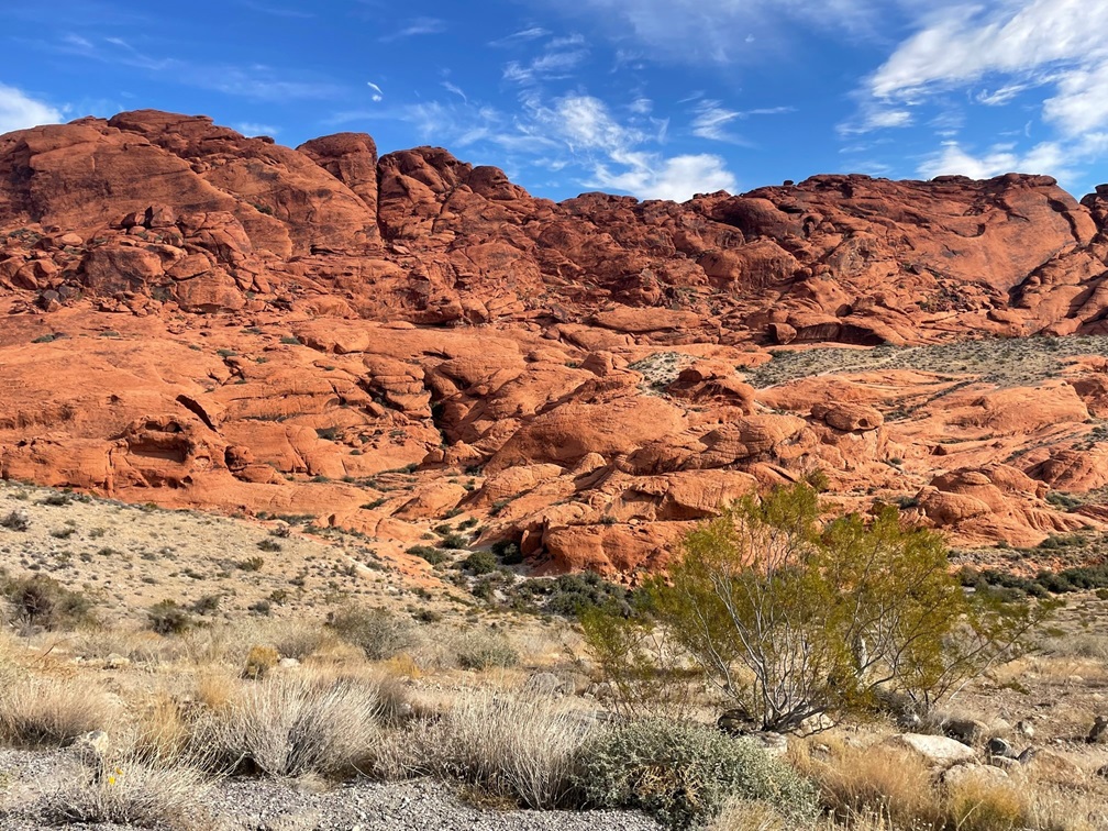
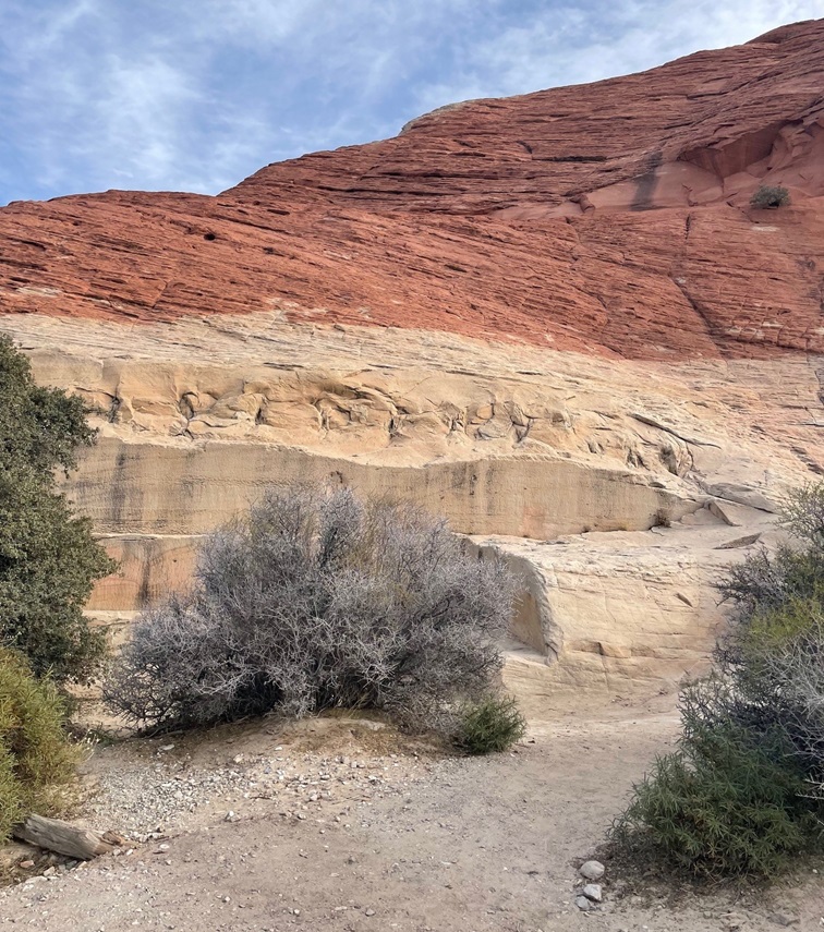
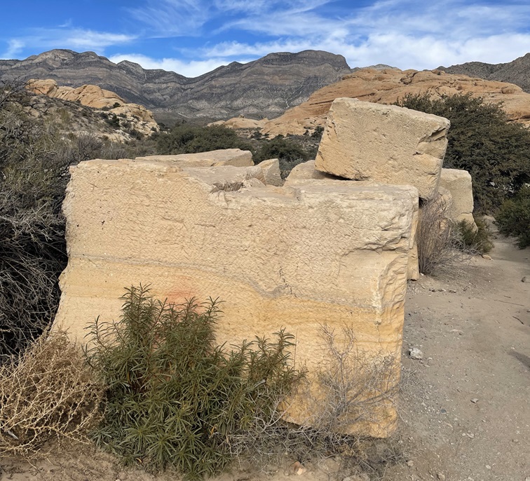
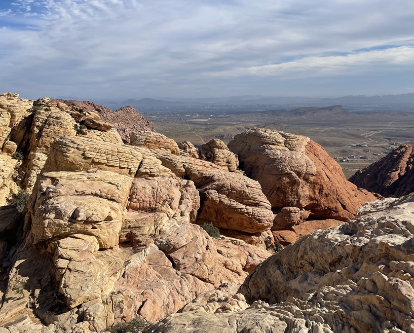
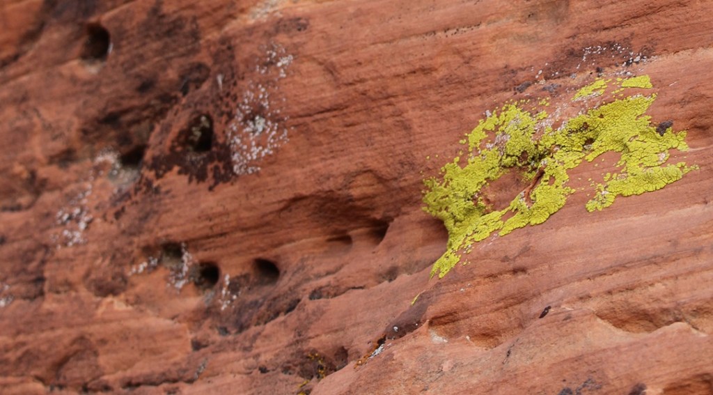
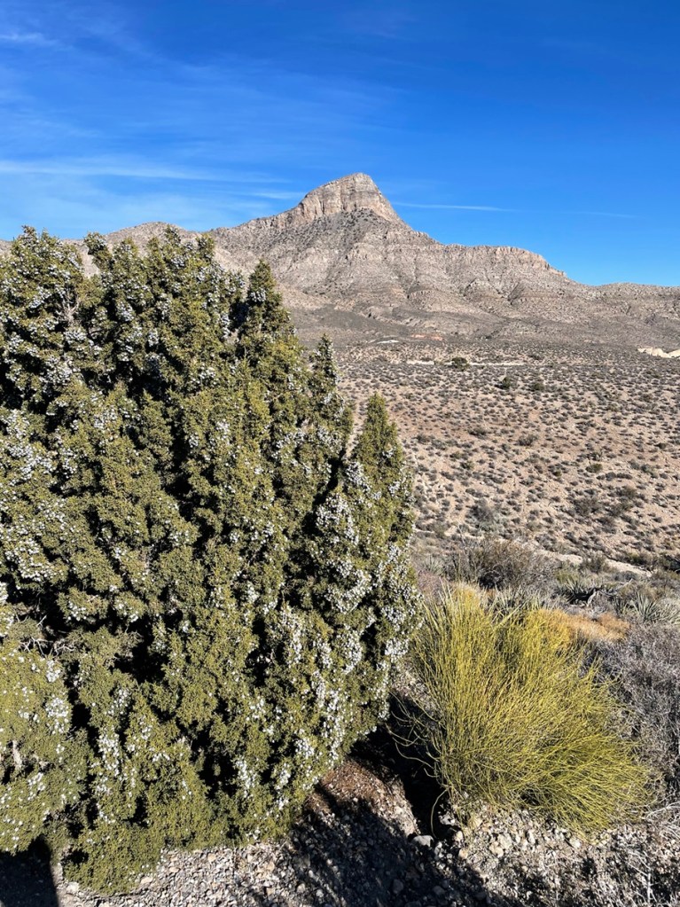
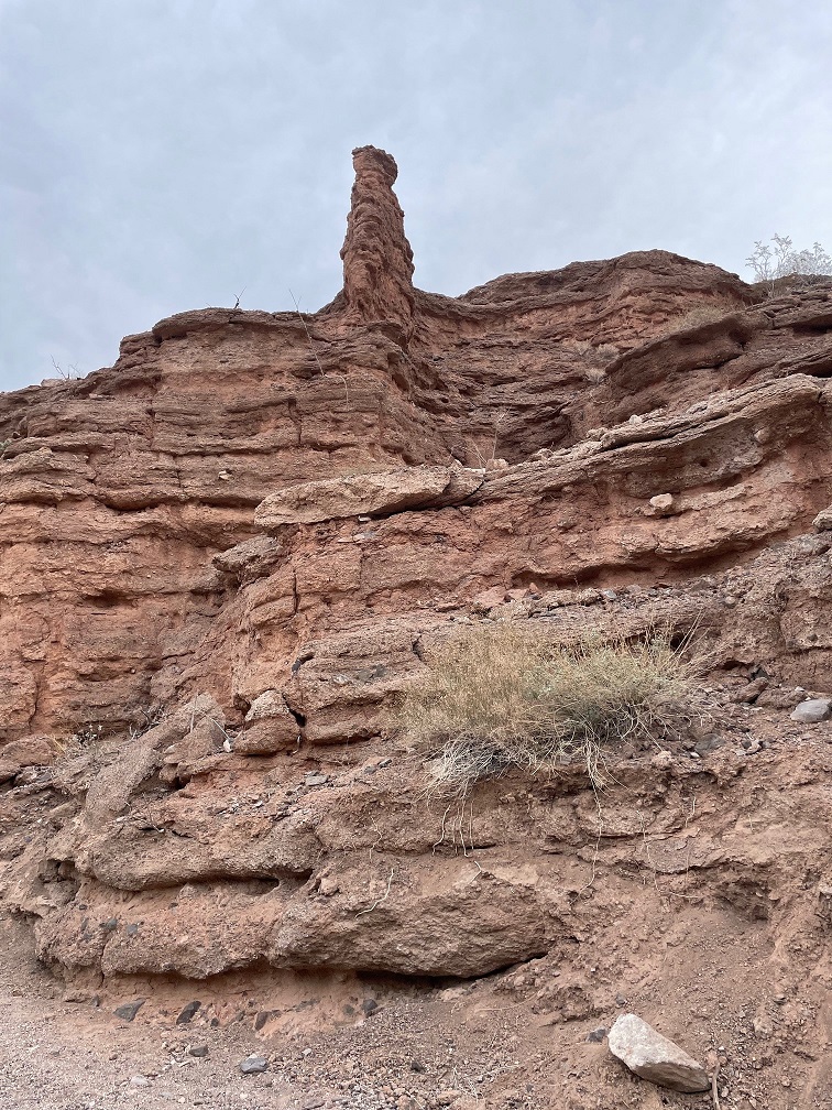
It’s easy to see how Red Rock Canyon got its name. The sand originally forming the dunes contained an abundance of minerals, one of which was iron that was oxidized by the elements over millions of years. The area began its federal protection in 1967, when the Bureau of Land Management (BLM) designated 10,000 acres as the Red Rock Recreation Lands. Further legislation over the years and significant additions of acreage eventually led to the National Conservation Area designation in 1990.I was struck by the clear delineation of colors in the rock. These two different colors of rock are both types of sandstone, but water moving through the sand at the bottom millions of years ago took away the red minerals and left behind calcium carbonate. The sand later developed, over even more millions of years, into sandstone.Erosional forces like water and wind result in some really cool-looking rock formations. Note, also, that the light-colored and red layers of rocks are the reverse of the photo above (and I didn’t post it upside-down).These huge sandstone blocks are not naturally formed: they’re remnants of one of the earliest industries in the Las Vegas area. The Excelsior Stone Quarry began operations in 1905, extracting blocks of sandstone for use as building materials. The blocks, some weighing up to 10 tons, were pulled with a 17-ton steam-traction engine to the just-built railroad in Las Vegas and loaded onto railroad cars bound for Los Angeles and San Francisco, where they served as decorative building material. While the sandstone was judged to be of exceptionally fine quality, quarries closer to California’s coastal cities were later developed and the Excelsior Stone Quarry and other operations in the area shut down for good in 1912. The plant growing in front of the large block is a species of yerba santa, which is Spanish for “sacred herb.” The name comes from the plant’s medicinal properties to treat respiratory and digestive ailments – even today, yerba santa extracts can be found in western U.S. herbal medicine stores.Part of the day included a hike on the Calico Tanks Trail. The long views and beautiful multicolored rock formations along the trail reminded Nancy and me of several places in Colorado, including Garden of the Gods in Colorado Springs and the Red Rocks Amphitheater near Morrison. Two hikers can be seen in the lower-left corner of this image. The BLM has classified the Calico Tanks Trail as “moderate”; I’d say, based on the elevation gain and necessity to scramble up and over rocks, it’s on the far end of “moderate.” It was a beautiful hike, though.These curves in the sandstone were created while the materials were still in the form of loose sand. Wind blowing across the dunes created these lifted layers before the grains of sand were cemented into the sandstone of today.This specimen of Spanish dagger (Yucca schidigera, also known as Mohave yucca) reminded us that we were in the desert. It, like many plants found in the Mohave and other deserts, looks pretty savage.Speaking of savage, Gunther takes a break on the Calico Tanks Trail to enjoy the scenery. He got along really well with the Canadians; he gets along really well with pretty much everyone, no matter their country of origin.This is the feature for which Calico Tanks Trail gets its name: a seasonal pond, or tank, created by water seeping or flowing into a depression in the sandstone (there was a much smaller water feature earlier in the trail, thus the plurality of the trail’s name). The Spanish word for this formation is “tinaja,” which means “clay pot.” The sun on this early December day was pretty low in the sky, making for some considerable shadows from the rock formations. Those of you who have been to Las Vegas will probably think this tank is the third-largest standing body of water in the area after Lake Mead and the fountains in front of the Bellagio resort on the Las Vegas Strip; I would not disagree with that assessment. Formations like this make possible a huge diversity of plant and animal life that otherwise couldn’t survive in the desert.If you squint, the hotels and casinos of Las Vegas can just barely be made out near the horizon in this image, taken at the end of the Calico Tanks Trail. This vantage point took some rock scrambling to get to; along with my phone, with which I took this and most of the rest of the photos in this posting, I was also carrying my digital camera with a large and heavy zoom lens in case we saw any wildlife. A fellow hiker noticed the camera and said I was brave for bringing it along; I corrected him and said I was dumb.So that I didn’t bring my heavy camera lens on the Calico Tanks Trail for naught, here’s a picture of a rock climber I took with it. Rock climbing is a pastime in which I have absolutely no interest in participating.Yeah, this looks like just heaps of fun. The BLM’s website states that rock climbing at the national conservation area is among the best in the world. Red Rock Canyon National Conservation Area is one of more than 850 areas managed by the BLM’s National Landscape Conservation System, which totals 27 million acres of areas designated as National Conservation Areas, National Monuments, Wilderness Areas, Wilderness Study Areas, Wild and Scenic Rivers, and National Historic and Scenic Trails.Longtime readers of this blog know that I won’t pass up an opportunity to post an image of lichen. I have no idea what species this is, but I think the shade of green is best described as “obscene.” Together with wind and moisture, plants and lichens do their part to erode the rocks into all kinds of fantastic formations.This is a view from High Point Overlook (elev. 4,771 feet) looking east toward the city of Las Vegas, which is 15 miles on the other side of the rock formation. High Point Overlook is just a little shy of the midway point of Red Rock Canyon’s scenic drive. The vegetation in the foreground gives an idea of what the flat parts of the area are like; it appears kind of sparse, but it’s much more heavily vegetated than other areas we’ve seen around Las Vegas. There are about 600 species of plants found in the conservation area, a number boosted considerably by the presence of year-round water: the sandstone allows water to percolate, creating springs, pools of standing water like the Calico Tanks, and even small creeks and waterfalls .This is Turtlehead Peak (elev. 6.323 feet), also photographed from High Point Overlook. There’s a trail to the top, but it’s 5 miles round-trip with a 2,000-foot elevation gain, and Gunther didn’t want to try it so we didn’t. That’s a heavily laden Utah juniper (Juniperus osteosperma) on the left, with Mormon tea (Ephedra nevadensis) growing at its base.I wasn’t planning to see any natural bodies of water in Red Rock Canyon National Conservation Area, let alone one that was flowing. This is Lost Creek, along which we saw a huge diversity of plant life flourishing in early December. I will remember this very short hike off the scenic loop for a couple of reasons: this stream, and the fact that Nancy bonked her head on a low-hanging ponderosa pine branch that was overhanging the trail; she didn’t see it because of her hat brim. If she hadn’t been in the lead of our hiking party, any of the other three of us would probably have bonked our heads (even though he was ahead of Nancy, Gunther didn’t bonk his head because he’s an expert hiker. And he was able to just walk under the branch, without making note of the obstruction to Nancy.) We’ve discovered that the maintenance of trails in the federal system can vary greatly; BLM trails are perhaps the most … rustic. It’s really not a problem, and I’m certainly not complaining. It’s just interesting to see.Here’s an example of the diversity of plant life in Red Rock Canyon National Conservation Area: a specimen of ashy silktassel (Garrya flavescens), growing along Lost Creek. I’ve never knowingly seen it before. It can grow up to about 10 feet high. Another short trail from the scenic loop leads to a grouping of petroglyphs and pictographs, created by native Americans thousands of years ago. The minerals in rock exposed to the intense desert sun over the millennia develop a dark patina called desert varnish. The native Americans removed the patina with stone tools to expose the lighter colors of the original rock beneath, creating designs known as petroglyphs. Pictographs, in contrast, are designs created with paints made with clays, charcoal, and other minerals, and then applied to the rocks.Here’s a closer view of the petroglyphs in the photo above this one. The meanings or significance of these designs have been lost to time; the only communicative records of the people who created these designs that still exist are the petroglyphs themselves. Nancy and I have seen quite a few petroglyphs in New Mexico and Arizona, but it was a bit surreal to see these ancient designs just 15 miles from the (barely) controlled 24-hour party of the Las Vegas Strip.Here’s an example of a pictograph, or an image painted on the rock, located just a few yards away from the petroglyphs. It’s a little hard to see in this photo, but petroglyphs and pictographs are themselves sometimes hard to see in the wild. There’s a closer view of the pictograph below.The pictograph looks like a figure 8 with a vertical line inscribed through it (it’s just to the right of dead center in the photograph above). Again, we have no idea what its significance is, but it must have been important to someone a very long time ago. The BLM and other federal agencies take great care to protect these cultural artifacts; like in other areas around the country, the precise locations of many of the pictographs and petroglyphs in Red Rock Canyon are not made available to the public. Six major groups of native Americans have lived in what is now Red Rock Canyon, beginning with the Tule Springs Paleo-Indian culture 11,000 to 8,000 years ago.
A visit to Red Rock Canyon National Conservation Area had been highly recommended by one of our Lyft drivers who happened to be a native of Las Vegas, and she was right to do so. I mean, we would have gone regardless, but our visit definitely blew past what I thought it would be like. I sure wasn’t expecting to see those incredible views, enjoy fascinatingly colorful rock formations, and go on a hike next to a running stream, let alone appreciate imagery left by native Americans thousands upon thousands of years ago, but Red Rock Canyon had all of that and more. If you do find yourself in the Entertainment Capital of the World and want to experience something completely unlike what Las Vegas is known for, Red Rock Canyon National Conservation Area is a wonderful place to spend a day.
Lake Mead National Recreation Area Near Las Vegas, Nevada – January 6, 2024
Impounded behind the concrete and steel of the magnificent Hoover Dam, Lake Mead in southeastern Nevada and southwestern Arizona is, by volume (and when full), the largest inland reservoir of water in the United States. There are a couple of U.S. reservoirs that have a larger surface area, but they don’t have the depth of Lake Mead (when full). The reservoir, made by the result of damming the Colorado River, is the primary feature of Lake Mead National Recreation Area – the nation’s first NRA as well as its largest at 1.5 million acres, or just over 2,400 square miles. For perspective, Lake Mead NRA is a couple hundred square miles larger than Kit Carson County in far eastern Colorado.
When full, Lake Mead has a surface area of 247 square miles, a surface elevation of 1,229 feet above sea level, and a maximum depth of 532 feet. When it’s full.
Lake Mead is, at the moment, not full. Not even close, really. In fact, it’s a couple hundred feet below its capacity, and it hasn’t been this empty since it was first filled after the construction of the Hoover Dam in 1937. A multi-decade-long drought in the southwestern United States, as well as unprecedented demand for agricultural and municipal water in the multi-state region served by the reservoir, have led to a stunning drop in the water level of Lake Mead. The reservoir’s capacity is so large that one inch of water in the lake equates to about 2 billion gallons. Two billion multiplied by 2,400 inches (200 feet) means Lake Mead has 48 trillion fewer gallons of water since the reservoir was last full in the mid-1980s. That number is so large as to be effectively useless, but in terms of acre-feet (which is the amount of water needed to cover an acre with 12 inches of water), Lake Mead is currently a little over a quarter of its capacity.
Geologists and hydrologists, along with other concerned -ogists, are working, and have been working for several decades, to address this issue. Many millions of people rely on Lake Mead’s water to continue flowing through the reservoir, providing electricity as well as drinking, municipal, and agricultural water. Mother Nature, while a powerful force in her own right, will take a long time to refill the reservoir: even after the remarkable upstream snowpack of the 2022-2023 winter in the Rocky Mountains, the reservoir rose only a few inches. It would take many consecutive decades of consistently above-average snowpack to refill the lake. That’s highly, highly unlikely to happen.
While the situation awaits a hopeful solution, that change in Lake Mead’s water levels also presents new opportunities for recreation: the receding water has left behind areas for great hikes. Recreation managers have developed at least 14 hiking trails all around the area, ranging from short and easy strolls to a 34-mile-long bike loop to strenuous hikes that are meant for the truly hardy among us.
Which neither Nancy, nor Gunther, nor I, are. We lucked into a great hike called the Owl Canyon trail on the first weekend of 2024, and saw some pretty cool sights while enjoying a 4-mile out-and-back trail.
We saw several of these beautiful buttes along the trail to Owl Canyon. The creek flowing below the butte at lower left is Las Vegas Wash, a 12-mile-long arroyo that channels most of the excess water from the Las Vegas metropolitan area into Lake Mead. The wash contains water from urban runoff, reclaimed water from golf courses and parks, and stormwater; in short, it’s probably best to not dip your tin cup in it for a cool, refreshing drink – although the plants and rocks of the wash do filter a lot of the contaminants out of the water before it reaches Lake Mead. This photo was taken perhaps a half-mile from the trailhead, which was a boat ramp that used to provide watercraft with access to Lake Mead. More on that later.Thousands of these small white mollusk shells can be found in several locations along the Owl Canyon trail. They point to a time, years ago, when this entire area was covered by a vast body of water: Lake Mead, which, when it’s full is about 60 percent bigger than the area covered by the city and county of Denver. As recently as the 1980s, mollusks like these were free to frolic or fritter away their days or whatever it is that mollusks do. Now, every foot of the trail we were on is high and dry.
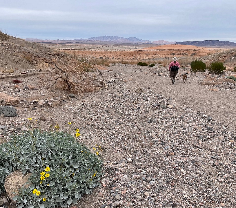
Here we see an intrepid hiker and her ill-behaved dog (it’s Nancy and Gunther) approaching the mouth of Owl Canyon, about a mile and a half from the trailhead on the boat ramp to the west. The canyon can also be accessed by a trailhead resulting in a shorter hike (2.2 miles out and back) coming from the northeast, but we wanted a bit more of a challenge for this first hike of 2024.
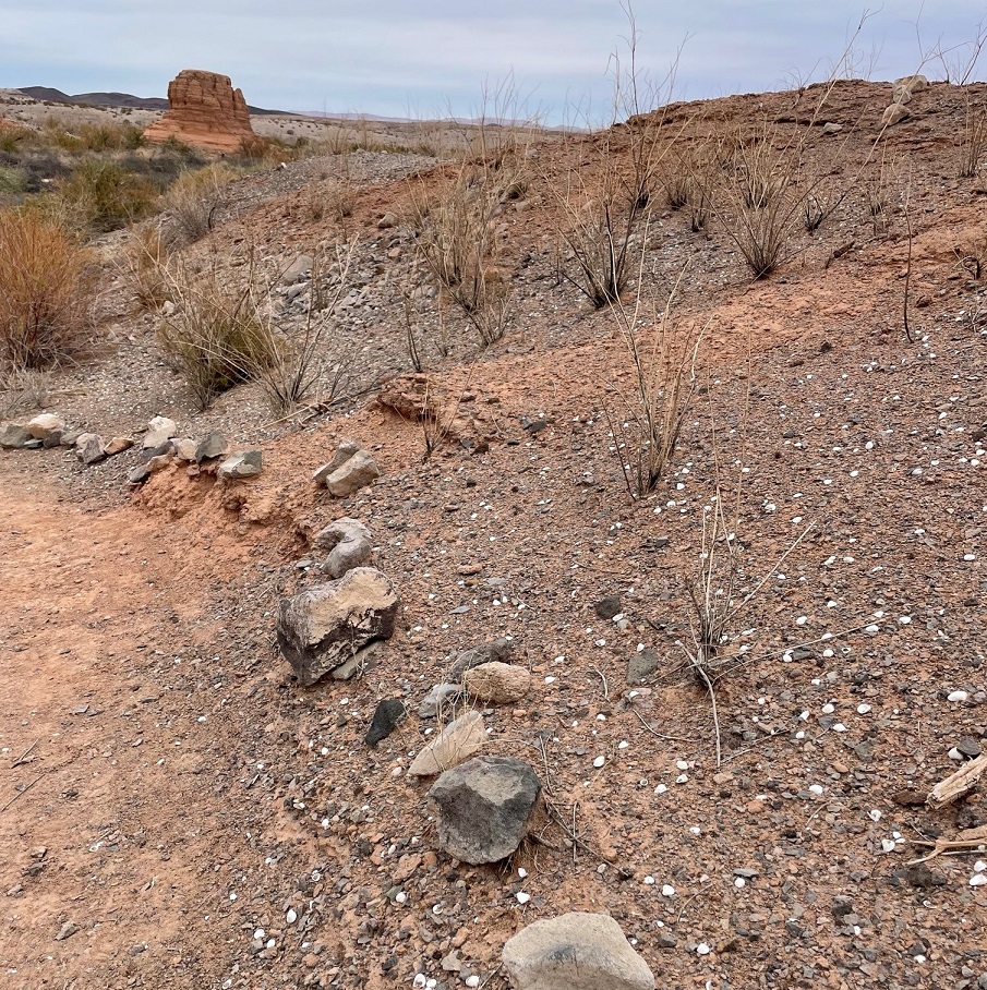
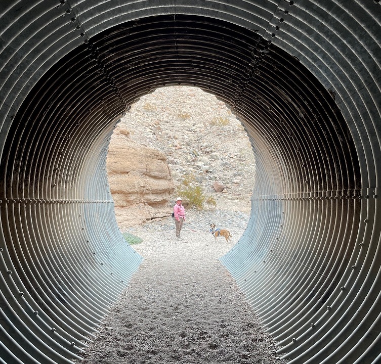
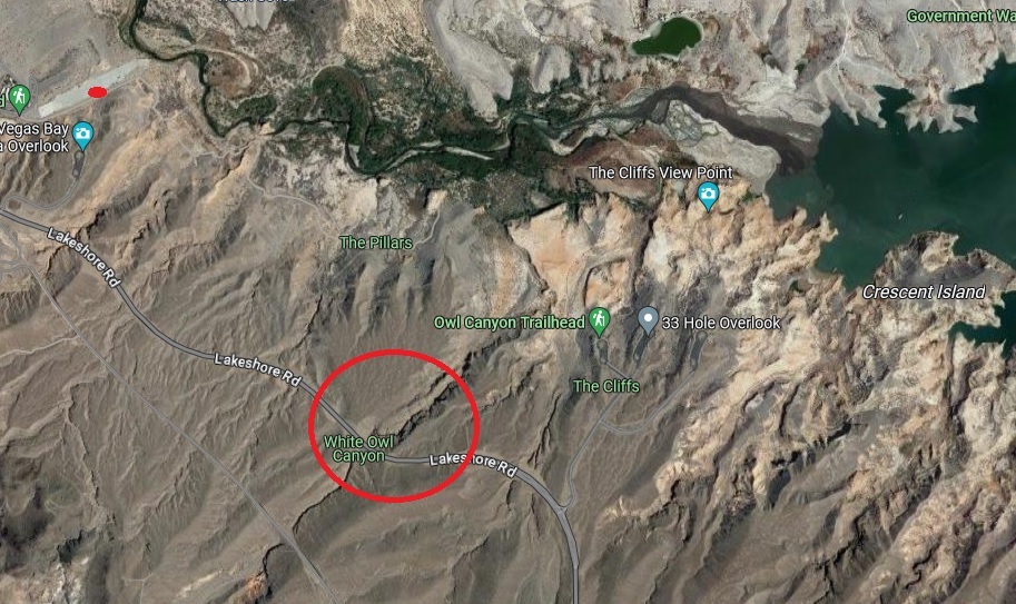
As you can probably tell from the earlier photos, it’s rather arid in the Lake Mead National Recreation Area (it’s in a literal desert, the Mohave, and the region is a convergence of the Mohave, Great Basin, and Sonoran deserts). Depending on which resource you use for reference, the area gets between 4 and 6 inches of precipitation each year. Except for a great blue heron, a small family of mallard ducks, and a large flock of goldfinches, we didn’t see much in the way in wildlife on the day’s hike. However, we did see some examples of desert plants that we hadn’t yet encountered on our travels. This is a specimen of desert stingbush (Eucnide urens), also known as velcro plant. It’s found in the desert regions of the southwestern United States and Baja California. It looks a lot like holly leaves seen around the December holiday, but, true to its name, the serrated leaves have stinging hairs to protect the plant from browsing animals. It’s yet another desert plant one wouldn’t want to lick (although the desert bighorn sheep native to the area seem to like them quite a lot).The walls of the canyon, which were under the waters of Lake Mead for many years, is made of a conglomerate of many different kinds and sizes of rocks, ranging from particles of sand to basalt stones the size of footballs or larger. Owl Canyon existed before Lake Mead; it was carved by an intermittent watercourse to create a winding natural path through the desert.The previous photo of the canyon walls’ conglomerate was taken near a spot in the canyon where we stopped for lunch. This photo was taken from the same spot. It shows Gunther alertly listening to Nancy about further instructions regarding the hike, especially to be constantly aware of impending threats from wildlife. (He’s really just waiting for Nancy to offer him some of her tuna salad sandwich; ultimately, he was disappointed to be denied the same.) The bandana he’s sporting around his neck was acquired gratis from a pet grooming service in Idaho over the summer; it looks like I neglected to iron it before we left on that day’s hike.Owl Canyon gets its name from the many holes in the rock walls that have eroded away, providing perches for owls and other roosting birds. Walking through its winding course was a ton of fun, although Gunther appeared to be ready to leave at any time.Of course, Gunther was right to be terrified. One drawback presented by the canyon’s winding rock walls was the inability to see anything around an upcoming bend, such as these remarkable multi-stone sculptures located just before a culvert in the canyon, until they suddenly appear before you. They were encountered on our return path through the canyon; they weren’t there when we walked through the culvert earlier and gave us something of a start. Their sudden appearance shall forever remain a mystery. (Seriously, a family also walking through the canyon must have put quite a bit of work into stacking these stones, and they did it in pretty short order. Park managers are strict when it comes to building even small piles of rocks: like graffiti on rock walls or otherwise defacing natural resources, despite how cleverly they’re designed, putting these formations together is forbidden.) That’s Lakeshore Road above the culvert.Here are Nancy and Gunther on the other side of the culvert pictured above. Walking through its galvanized confines as we hiked underneath Lakeshore Road was an interesting experience. I found, to Nancy’s delight, that it provided quite an echoing experience. There are two culverts in Owl Canyon; they allow seasonal water runoff to continue on its natural course through the canyon on its way to Lake Mead.Erosion from water and wind creates some spectacular rock carvings. Vertical formations like this, like the much larger butte pictured earlier, are created when the erosional forces of water and wind take away rock material surrounding a structure, but the formation itself is protected on its top by a layer of less permeable rock. I’d guess that this formation at the top of the canyon wall is 12 to 15 feet tall.Nancy and Gunther emerge from the canyon and prepare to return to the trailhead; Gunther, in particular, appears pretty happy to be out. That’s a brittlebush (Encelia farinosa) plant in the lower left, displaying its bright yellow blossoms on this early January day. Perhaps unsurprisingly, brittlebush is a member of the sunflower family.On our walk back to the trailhead, we saw this striking shrub we hadn’t noticed while hiking to the canyon. I inset a closeup of the plant’s leaves in the lower right. It’s a pretty plant, isn’t it, with its deep red limbs and attractive dark green and juniper-like leaf structures? Don’t be fooled! This is the scourge of the southwest, an invasive plant called tamarisk (Tamarix ramosissima) that’s native to Europe and Asia. Land and river managers throughout the southwestern United States spend a lot of resources trying to control the spread of tamarisk, the flowers of which each contain thousands of tiny seeds. Younger tamarisk plants compete with native plants for water along riverways; tamarisk doesn’t grow well in shade, so if the native plants are able to outgrow tamarisk (which can grow to heights of 25 feet in full sun and with sufficient water), the natives will usually win out. This particular plant was growing quite a ways from Las Vegas Wash.This is a view of the length of the boat ramp that now serves as a parking lot for a couple of hiking trailheads, including the Owl Canyon Trail. I took this photo as we were driving away from the trailhead. You can barely make out the white paint on a couple of vehicles parked on the right side of the ramp near its end. Las Vegas Wash is just beyond the end of the ramp. When the lake is full, a lot of this ramp would be underwater. Keep scrolling to see what it would take to get this boat ramp functional for launching boats into Lake Mead again.Here’s some perspective of how low Lake Mead is. This is a screenshot from Google Maps, using satellite imagery taken from about 250 miles above the earth, of the area in which Nancy, Gunther, and I hiked. The boat ramp pictured in the photo above this screenshot is the small gray strip in the upper left corner; we parked the Goddard’s six-wheeled towing unit approximately where the red dot is. Owl Canyon is in the red circle; we hiked from the boat ramp, to and through the canyon, and back again. Las Vegas Wash is the creek at the top of the image flowing into Lake Mead in the upper right corner; when the lake was full, it extended west all the way to cover a lot of the boat ramp on the left side of the image. In short, the end of the boat ramp is at least three miles from the current waters of Lake Mead, and the lake would still need to fill much more in order to actually launch a boat from the ramp. When we finished our hike we happened to meet an construction engineer on the boat ramp who was doing some preliminary evaluation to prepare for its eminent demolition and extraction of the concrete, rebar, and other materials. As he told us, “This lake isn’t filling in our lifetimes.”
It’s easy to think that it’s not the end of the world if Lake Mead continues to dry up: the Colorado River flowed freely through this area for millions of years, supporting all kinds of native plant and animal life. But that’s not the world in which we currently live, and the disappearance of Lake Mead would be an absolute catastrophe: without constant flowing water to turn Hoover Dam’s turbines, many metropolitan areas in the southwest, like Phoenix, Las Vegas, and Los Angeles (to say nothing of the many thousands of smaller cities in the region), would suffer calamitous losses of electricity as well as a reliable source of water. Simply put, water impoundments like Lake Mead (and, to lesser but still vital extents, Lake Powell and Blue Mesa Reservoir upstream) make habitation of the southwest possible. Ain’t nobody living in Phoenix or Las Vegas in the 120-degree temperatures of July without air conditioning provided by electricity, to say nothing of being able to turn a faucet and expect water to come out.
It’s sobering to think that every step we took on this hike was once well underwater in Nancy and my lifetimes. Fortunately, smart and committed people are working on ways to continue developing and encouraging water conservation in the American southwest, but committed people will also need to actually take those steps in order to keep water flowing through Lake Mead.
As I related in a previous posting, we spent two weeks of March 2023 in McDowell Mountain Regional Park, a huge protected expanse of land east of the Phoenix, Arizona, metropolitan region. While that posting approached the avian aspects of the park, this one will focus on the floral features of the McDowell Mountain area. Keep in mind that all of these photos were taken in the last two weeks of March, when much of the rest of the western United States was just beginning to emerge from winter. Since Nancy and I are both from Colorado, about the only flowers we’re used to seeing that early in the year are those of crocus, narcissus, tulips and other bulb-born blossoms. The blooms of these flowering plants of the Sonoran Desert provided plenty of color in a landscape that otherwise seemed to be generally green and brown, as seen in the saguaro landscape above. (By the way, if you’re a beer aficionado, in the background you will recognize the four mountain peaks used on the labels of the Tempe, Arizona-based Four Peaks Brewing Company. I’m suddenly in the mood for a Kilt Lifter.)
Like most of the western United States, the Phoenix area received an above-average amount of precipitation during the 2022-2023 winter. That, along with occasional rain showers while we were at McDowell Mountain in March, resulted in some spectacular wildflower displays.
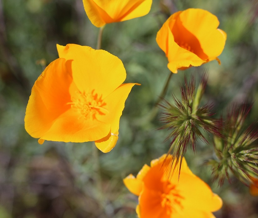
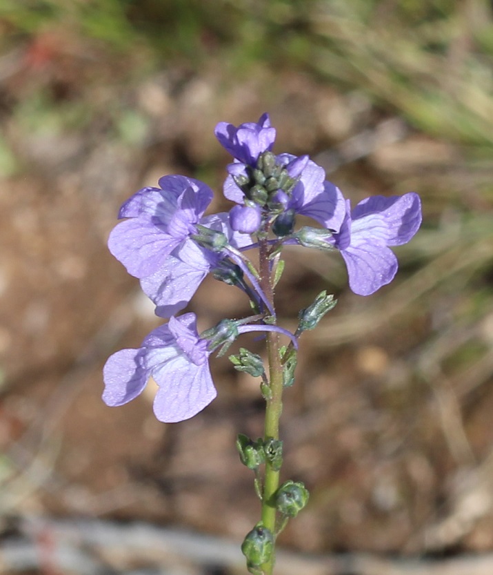
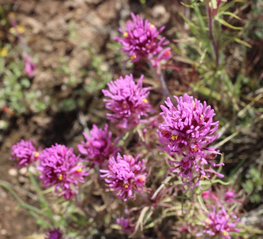
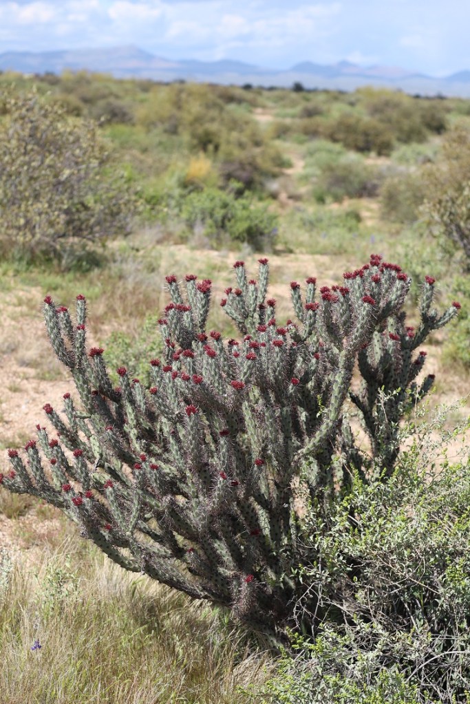
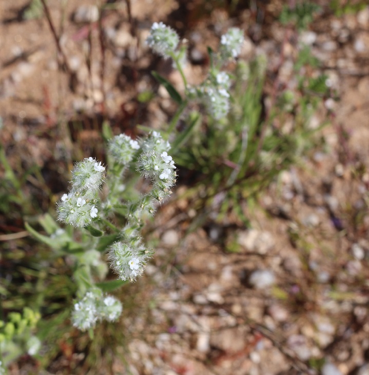
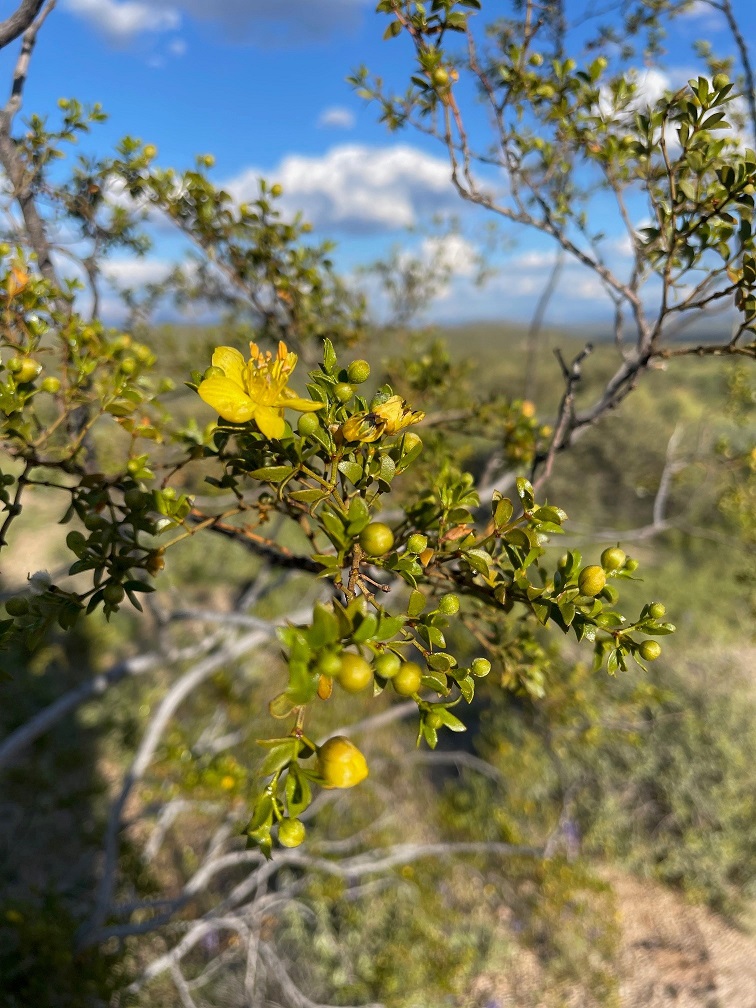
First up is the very common but colorful California poppy (Eschscholtzia californica), of which we saw plenty while in the park. It’s possible that this is another species called Mexican gold poppy, but I do think that, based on the flower coloration, this is the California species. The petals of these flowers close as evening approaches, and then begin to open again when the sun rises.California poppy plants grow to a height of 8 to 24 inches, and their blossoms can be 1 or 2 inches wide. I inadvertently planted a lot of this species in the xeriscaped part of our yard in Denver – the seeds were included in wildflower packets, and after a couple of years the poppies began to take over the area. Still, these plants produce some pretty eye-catching color. The California poppy is the state flower of … California.Texas toadflax (Nuttallanthus texanus), a member of the figwort family of flowers, grows to a height of about 28 inches. It’s a very spindly plant topped with some spectacular flowers that, because of their size, need some closer examination to appreciate; if you just walked by these flowers, it’d be easy to miss their delicate beauty.The bluish-violet color of this toadflax’s flowers is really pretty, I think, as is the complex structure of the blossom. The flowers grow on a structure called a raceme, a stalk in which the youngest flowers grow on smaller stalks at the top and the lower, older blossoms begin to develop into seeds.Castilleja exserta is one of about 200 species of Indian paintbrush found in western North America down through South America. Native to the southwestern part of the country, the plant grows to a height of 4-18 inches. Like all other Indian paintbrush species, exserta Indian paintbrush (also commonly called purple owl’s clover) is parasitic: it gets nearly all of its nutrition by using a specialized organ called a haustorium to attach itself to another plant species. Indian paintbrushes are some of my favorite plants; I tried to grow them at our Denver house next to some buffalograss for sustenance, but to no avail.Ocotillo (Fouquieria splendens) is a common plant seen from west Texas to southern California. They grow to an impressive height of up to 30 feet, and in the spring produce bright red flowers at the top of their many stalks. We were just a tad too early (or maybe too late; I’ve never seen ocotillo in bloom) to see these buds blossom. The flowers, which flower to coincide with hummingbird migrations for their pollination, give the plant its name: ocotillo means “little torch” in Spanish. Ocotillo are really interesting plants: they grow those tiny leaves seen in the above photo after a rainfall, and then drop the leaves when dry conditions return. It’s a cycle that can happen four or five times during the growing season.I think we were also at McDowell Mountain Regional Park too early in the season to see the saguaro cactus (Cereus gigantea) bloom, too. However, we did see some of these mighty cacti beginning to grow new arms, as seen on the left of this photo. Saguaros, which grow to a height of 50 feet, are very long-lived cacti: the oldest are estimated to be 200 years old. They don’t start forming arms like this until the plants are 70 to 100 years old, depending on the amount of precipitation they receive. Saguaro flowers, which grow at the top of the cactus, are white and grow to a width of 3 inches. The blossoms open at night and are pollinated by a variety of insects as well as bats. Saguaro blossoms are the state flower of Arizona.You wouldn’t guess it by looking at Esteve’s pincushion (Chaenactis stevioides), but this pretty plant is a member of the sunflower family. Reaching a height of 4 to 10 inches, it grows across the western United States, from southern Oregon and Idaho, down to New Mexico, and east to Wyoming and Colorado.The park had a lot of buckhorn cholla (Cylindropuntia acanthocarpa) in bloom; these large cacti seemed to be popular perches for birds. Buckhorn cholla cacti, of which there are six varieties, are found in the Sonoran, Mojave, and Colorado deserts of North America.I’d think a bird would find a more comfortable place to perch than on the top of a buckhorn cholla (pr. CHOY-ah), but I suppose they know what they’re doing. We had a different species of cholla along a south-facing exterior wall of our house in Denver; I’ve no idea what species it was (it wasn’t as branching as a buckhorn), but it had pretty flowers in the spring as well.I think of all of the flowers in bloom while we were at the park, desert globemallow (Sphaeralcea ambigua) was probably the most prevalent. It’s the orange-colored flower on the left, and the plant is still used by members of the Shoshoni and other Native Americans as a food and medicine source. It’s very common in Arizona; at another camping spot in the extreme northern part of the state later in the year, we’d drive by fields of it in which the blooms probably numbered in the millions. It is a popular cultivar for home xeriscaped gardens. The yellow flower on the right is brittlebrush (Encelia farinosa), which we first encountered at southeastern Arizona’s Gila Box Riparian National Conservation Area in January 2022. Its growth habit varies widely; it can be a foot tall or grow to a height of 5 feet.Here’s a closer view of the brittlebush flowers. It derives its name from the delicate nature of its flower stems. The plant’s sticky sap lent itself to a wide variety of uses among Native Americans and early pioneers in the southwestern United States, including as a glue, a sealant, and a waterproofing agent. It, along with the desert globemallow, was everywhere in the park. The plant is commonly found in the southwestern United States and northern Mexico.While its flowers are attractive enough, I really liked the foliage of redstem stork’s bill (Erodium cicutarium). This is not a native of the southwestern United States; it was brought to this country in the 1700s from the Mediterranean region of Eurasia and northern Africa. This plant has an interesting seed distribution system; in a process known as explosive dispersal, part of the flower changes its shape into something of a coil and stores up elastic energy. When enough energy has been created, that part of the flower, including the seed, bursts away from the plant. Once on the ground, the part of the flower containing the seed waits until soil conditions become wet enough for it to bury itself into the ground and germinate.Here’s one more cactus, the teddybear cholla (Opuntia bigelovii) that, again, was not in bloom while we were at the park (the yellow-green flowers are a couple of inches wide). I took this photo after a brief late-afternoon rain shower and liked the lighting. Despite its name, this is not a plant you’d like to even get close to: its small joints will readily detach from the main plant at the slightest touch (it’s also known as jumping cholla), and the spines have backward-facing barbs to ensure that they stick. On walks around the park with Gunther, we’d see a lot of these cacti with little balls of spines at their bases. Teddybear cholla grow to heights of 3 feet up to a truly terrifying 9 feet.Let’s move on to something less threatening. Here’s panamint cryptantha (Johnstonella angustifolia), also known as panamint catseye. It’s native to the southwestern United States and northern Mexico. It grows to a height of 2 to 12 inches, and is an annual wildflower – the plant produces flowers which develop into seeds, and, although the original plant dies, those seeds produce new plants the following growing season. In a very harsh desert landscape filled with plants covered in thorns, spikes, barbs, needles, and other sharp things, it was nice to find a relatively soft-looking flower.To wit: even this Menzie’s fiddleneck (Amsinckia menziesii) has small barbs on it (to say nothing of the thorns of the neighboring fishhook cactus in the lower left). Its seeds are a favored food for goldfinches (who’d have to be pretty hungry to get past the cactus thorns). The flower head of a fiddleneck sometimes curls gracefully into the shape of the head of a violin, giving the plant its name.I’ve enjoyed seeing the creosote bush (Amsinckia menziesii) in our travels around New Mexico and Arizona, and it was neat to see one in bloom. The smell of a creosote bush, especially after a rain, is really wonderful. A creosote bush creates clones of itself as it grows older – typically around the age of 60 to 90 years. Eventually the interior original plant dies, but it is surrounded by a ring of its clones. A ring of creosote in California’s Mojave Desert, called “King Clone,” is estimated to be nearly 12,000 years old – it’s one of the oldest organisms on the planet.I’ll close with this image of a fairy duster (Calliandra eriophylla) that I took perhaps 20 yards from the Goddard’s campsite. Fairy dusters, which grow to a height of between 8 and 20 inches, are fairly ho-hum shrubs for most of the year, but they produce some spectacular flowers in the spring.
There are several more photos I could include, but I think this posting has shown the incredible variety – the color, the blossom structure, the life cycles – of flowering plants in the Sonoran Desert. As was the case with the birds of McDowell Mountain Regional Park, I was really struck by the tremendous depth and breadth of the flower species variation. To be sure, the desert doesn’t look like this year-round, and it had been an especially wet winter and early spring, but under the right conditions a walk around the Sonoran Desert can be incredibly rewarding – as long as you don’t walk into a teddybear cholla.
Much of the identification of these plants was made possible by referencing the National Audubon Society’s Field Guide to North American Wildflowers, Western Region (ISBN 0-394-50431-3). Additional information came from Wikipedia, which I lean on pretty heavily for a lot of what I write – if you use Wikipedia much at all, please consider supporting it. I recognize that it’s not the end-all, be-all of sourcing information, but it’s a great starting point as a resource and available to everyone with an Internet connection.