Finding a parking spot for our Ford F-350 pickup, the 22-feet-long and six-wheeled towing unit of The Goddard, is sometimes a challenge. We usually just park on the outskirts of businesses’ parking lots because, unless the parking spots are oversized, we sometimes take up more than one space. When visiting Yellowstone National Park in September, we realized that we needed to get early starts in order to find spaces in the park’s parking lots: we arrived after Labor Day and park rangers assured us that visitation had noticeably dropped, but parking spaces were still at a premium beginning in the late morning hours, So it was when we visited Norris Geyser Basin, located in Yellowstone’s northwest quadrant: we arrived at about 8:30 AM on September 12 and happily found a parking space. It was already getting pretty chilly in mid-September: high temperatures in the basin that week were in the mid-60s Fahrenheit (about 18 degrees Celsius) and pre-dawn low temperatures were in the low to mid-30s Fahrenheit (about 0 degrees Celsius).
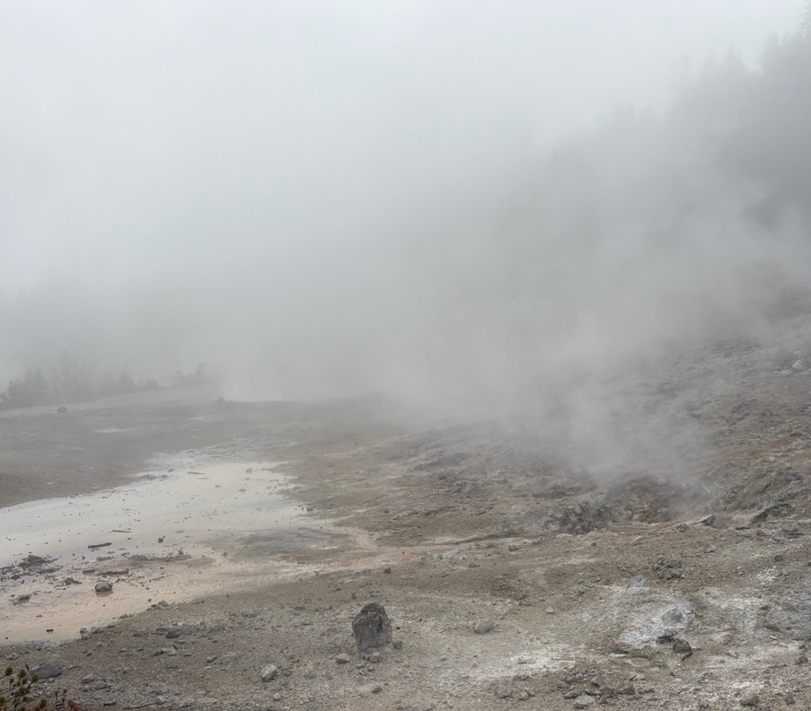
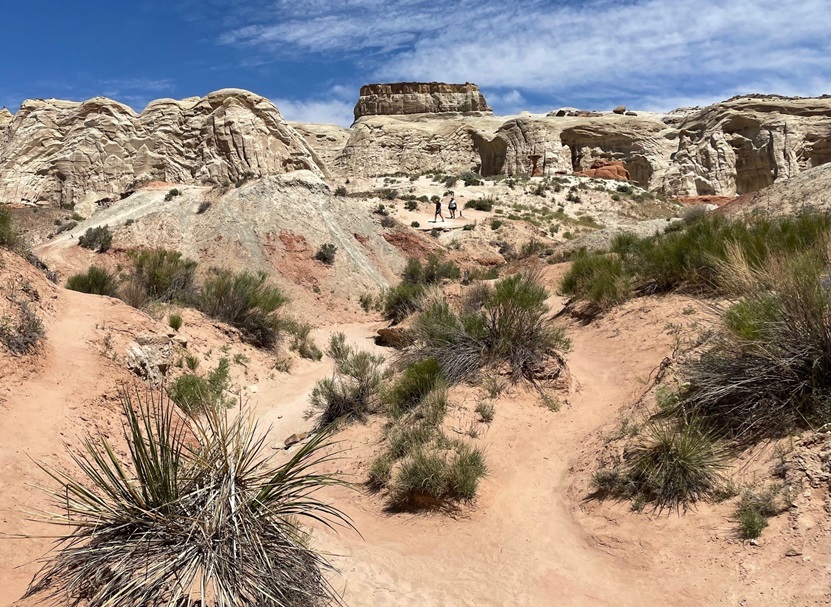
Those cold air temperatures combined with the hot steam rising from abundant geothermal features to create an otherworldly effect; it was extremely foggy, which made it difficult to discern any of the geysers, hot springs, and other features. The day soon warmed up, however, and the features revealed themselves. There are two different loop walks around Norris Geyser Basin: the longer and more forested Back Basin, which we visited later the same day (see that posting for an explanation of the different types of hydrothermal features, which I won’t repeat here), and Porcelain Basin. Here’s a look at some of what we saw in Porcelain Basin, once the air cleared a bit.
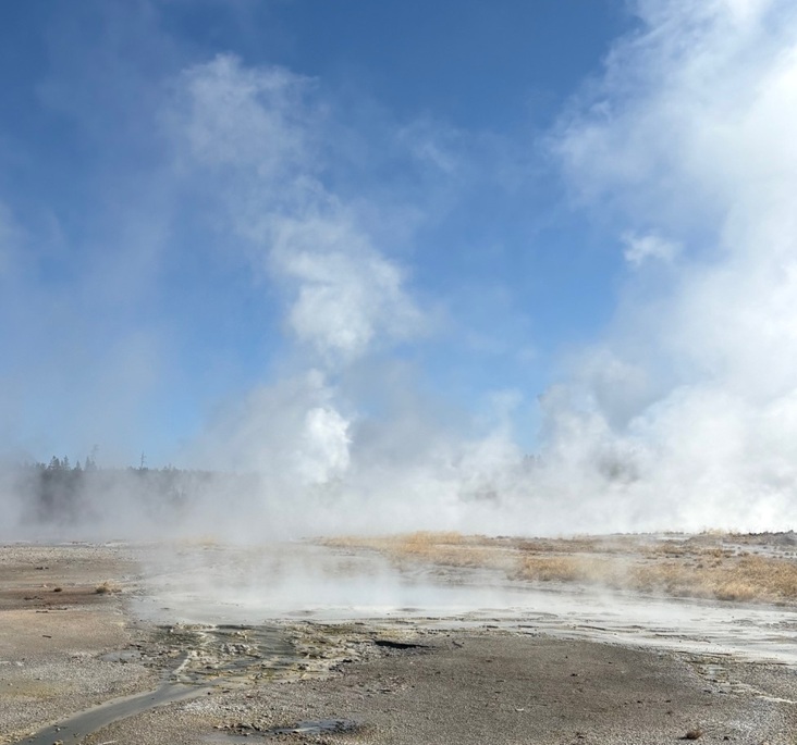
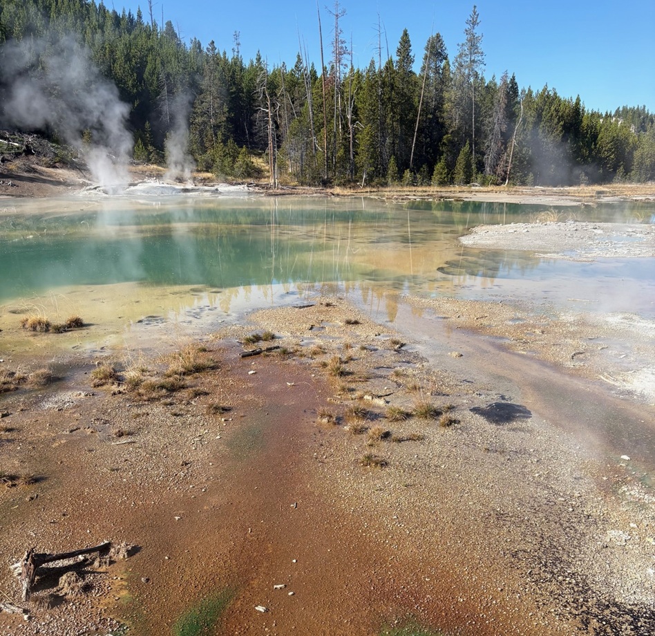
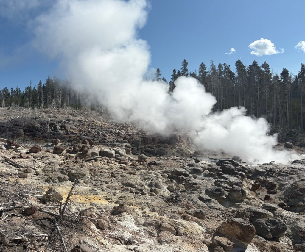
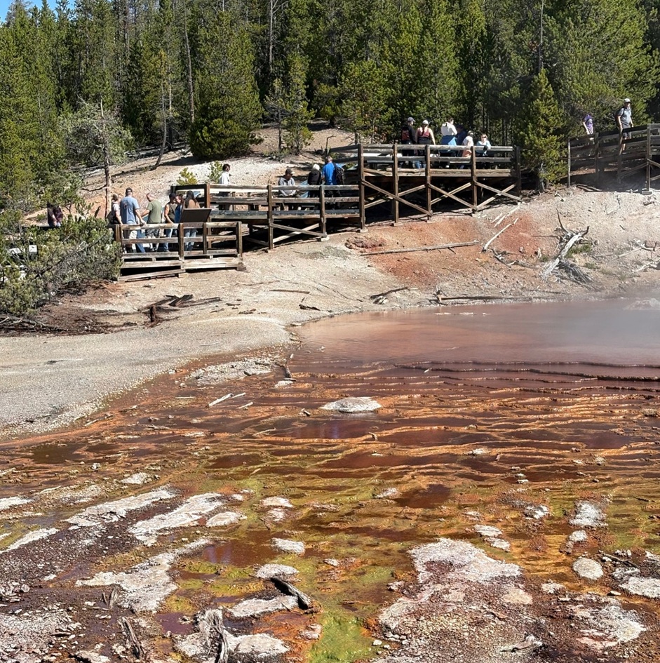
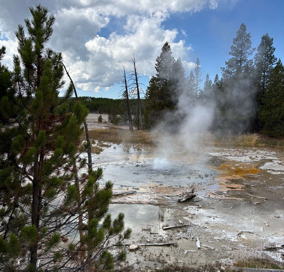
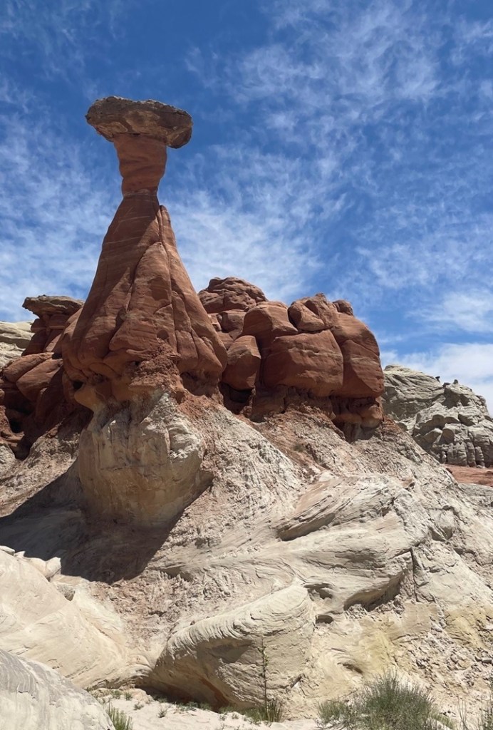
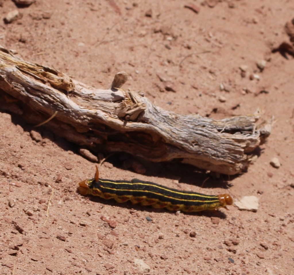
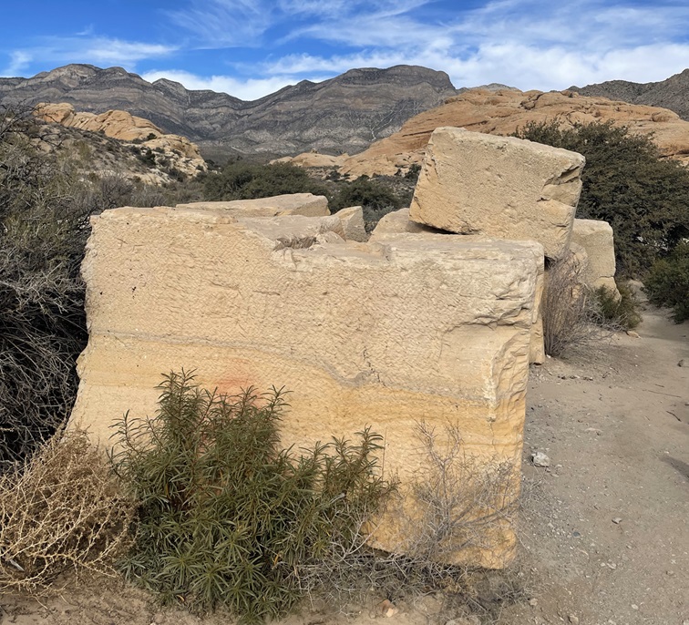
Those are some impressively large logs. This is the north-facing side of the Norris Geyser Basin Museum, designed by architect Herbert Maier (1893-1969) and built between 1929 and 1930. The museum, at 7,560 feet (2,304 meters) in elevation, was our first stop at Norris while we waited for the fog to dissipate. Maier also designed three other buildings in Yellowstone National Park: still-standing museums at Madison and Fishing Bridge, and the Old Faithful Museum of Geothermal Activity. Together, the four structures, built in an architectural style known as “National Park Service Rustic” that attempted to connect manmade buildings with the natural environments in which they were constructed, interpreted the geologic features on the Grand Loop road. Unfortunately, the museum at Old Faithful was demolished in 1971 to accommodate a new visitor center; that structure was itself demolished to make way for the current visitor center that opened in 2010. Maier also designed still-standing buildings in Yosemite National Park in California and Grand Canyon National Park in Arizona, as well as a number of structures in state parks in Texas.This picture, I think, really captures the extraordinary beauty and kaleidoscopic color of Yellowstone National Park. (Not really: it captures the foggy conditions at Porcelain Basin for the first hour or so after our arrival.) This hillside is venting sulfuric acid, gas, and steam, and the colder temperatures on the morning of our visit made the venting look quite pronounced. Norris Geyser Basin is the hottest area in Yellowstone National Park, in which one only needs to dig four miles downward to find magma – rock that’s so hot that it has become liquified (one wouldn’t necessarily want to do that, though). The average surface temperature in the basin is 280.4 degrees F (138 degrees C), and a probe sent 1,086 feet (331 meters) under the ground’s surface registered a temperature of 464 degrees F (240 degrees C). A vent from which gases and steam escape is called a fumarole (from the French fumerolle, which is a domed vented structure built over a stove to allow steam and smoke to escape); a fumarole that vents sulfuric gases (like these in the photo) is called a solfatara, while a fumarole that vents carbon dioxide gases is called a mofetta. A muffuletta is a delicious Italian sandwich popularized in New Orleans, but that’s not important right now.These pools, collectively called Porcelain Springs, give their name to the basin. They’re supposedly very pretty when the sun is shining on them, but I guess we’ll never find out for sure. The white mineral surrounding the bodies of water is called siliceous sinter, also known as geyserite. The silica is brought to the ground surface by the hot water in the pools, and accumulates very slowly – about an inch per century. Relatively new sinter is white; as it ages it turns to a darker gray color. The hydrothermal features in the greater Norris Basin, including both Back Bay and Porcelain basins, contain the highest level of silica in Yellowstone National Park – it’s what contributes the white milkiness (some might say porcelain-like) attribute to these bodies of water. Other minerals, like iron, arsenic, and sulfur, are all abundant as well. The latter contributes a distinct aroma to walks around these basins.This photo, too, is indicative of what we saw while waiting for the fog to go away. As you can see, Porcelain Basin is not a terribly inviting place if the sun isn’t shining. These trees, interestingly, found the conditions in the soil conducive to germinate, grow, and mature into tall pines; the soil conditions later changed because of geothermal activity in Porcelain Basin and made the ground inhospitable to many lifeforms. Most of Norris Geyser Basin is walkable only on boardwalks like this one: the ground is too fragile (and, remember, it’s nearly 300 degrees) for visitors to walk on directly.I took this photo from about the same position as the previous one (the boardwalk is just to the right side of the image), but looking slightly to the left and about half an hour later. You can see the sun was starting to emerge but steam is still rising from Nuphar Lake, which is itself not a geothermally heated body of water – it’s just plain old steam evaporating as the air temperature rises. Nuphar Lake (nuphar is a genus of flowering aquatic plants) has an interesting recent story, however. In 2021 and 2022, the lake’s water level rose by several feet (about one meter). Apparently, a geothermal feature near the lake began sending silica-laden water into the lake rather than into Porcelain Basin, which turned the lake’s water cloudy-white. The water level rose so dramatically that Nuphar Lake threatened to overflow its banks and into Porcelain Basin (which would have been pretty bad, because there are a lot of really pretty features there). By the end of the summer of 2024, though, the water level receded to its previous level and the color of the water returned to its normal clear green. Geologists found that an earthquake that occurred in April 2024 near the lake created a 10-foot-wide (about 3 meters) crater and caused water to stop flowing from the hydrothermal features. The dead trees in the previous photo, and those in the foreground of this photo, were killed by the silica-rich hydrothermal water that had been flowing into Nuphar Lake. That’s one big takeaway from our visit to Yellowstone National Park: nothing’s ever the same, and you can’t count on anything being there on a subsequent visit.Well, well, well … look what decided to finally show up: the sun. This is the same Porcelain Springs body of water that’s in the upper-left corner of the image three photos up. A sunny day does make all the difference – they are very pretty after all. Like porcelain, almost.The steam in Porcelain Basin, made more prominent because of the morning’s cold temperatures, was finally starting to dissipate so that we could see what else the basin had to offer. The sun was already pretty high up in the sky by that point, but it made for an interesting look. No retinas were damaged in the taking of this photo; the steam was a lot denser than it looks in the image.This is Hurricane Vent, which once was a fumarole but has increased in size to include more water action as well as a small waterfall on its side. It was pretty noisy, and interesting to watch.I took this photo just a few steps down the boardwalk from Hurricane Vent. This is looking to the southwest and at Ledge Geyser, which, while it rarely actually erupts, was certainly impressively active and loudly spouting steam from several of its vents during our time in Porcelain Basin. When Ledge does erupt, the geyser sends water more than 80 feet (24 meters) into the air. The Norris Geyser Basin Museum is on the other side of Ledge Geyser and up a hillside in this photo.Here we’re looking northeast from the Porcelain Basin boardwalk and at Constant Geyser. When it erupts, Constant’s spouts of water can reach 20-30 feet (6-9 m) into the air, but last only about 10 seconds. The geyser can go 20 minutes or several hours between eruptions.A few steps down the boardwalk, Whirligig Geyser (on the right) has eruptions that can be heard throughout Porcelain Basin. That green-hued stream on the left is the East Fork of Tantalus Creek.Here’s a closer look at the East Fork of Tantalus Creek. In Greek mythology, Tantalus was one of the (many, many, many) sons of Zeus who, for whichever transgression(s) you might choose to believe, was sentenced to stand in a pool of water under a fruit tree. The fruit was forever just outside his grasp, and, when he bent to get a drink, the water below him always receded. Anyhow, the beautiful green color of this creek comes from the thermophiles, or heat-loving microorganisms, that live in the water, in particular Cyanidioschyzon (I did not, despite how much I would have liked to, make that word up). It’s a genus of algae that thrives in water that’s 100-126 degrees F (38-52 degrees C). The steam from Whirligig Geyser is obscuring them in this photo, but there’s also a population of red-colored thermophiles that is thriving in hotter waters (122-160 degrees F, 50-60 degrees C) closer to Whirligig’s opening. The red coloration comes from the iron oxide that is in the geyser’s outflow. You’ll recall from high-school biology and chemistry classes that the pH scale is used to measure the concentration of hydrogen ions in a chemical. The scale goes from 1 (most acidic) to 14 (most alkaline), with 7 in the middle at neutral. Some of the water features in Norris Geyser Basin have a pH value below 2; they’re nearly as acidic as vinegar. It takes a tough little organism to live in that hot, acidic environment.This body of water, situated near the end of the Porcelain Basin loop, is Crackling Lake, named for the popping sounds made by geysers seen on its shoreline on the left.Here’s a last look at Ledge Geyser. This photo was taken from the other side of the plume of steam from where I took the previous photo of Ledge (note the other folks on the boardwalk looking at Constant, Whirligig, and other geysers to the left-center of the photo). Even though it never erupted, Ledge Geyser was a most impressive hydrothermal feature that made it hard to forget that molten rock was just four miles below our feet.
After a brief respite in the parking lot (and our prime parking spot) for lunch, Nancy and I enjoyed the features of Back Basin. We saw a lot of hydrothermal features that day – fortunately the fog over Porcelain Basin lifted about an hour after our arrival so that we could see them – and my guess is that the next time we visit, we’ll see a difference in a national park in which nothing is ever truly the same.
Works Consulted
Lynne, Bridget Y. “The Geothermal Guide to Yellowstone National Park.” 2017.
National Park Service. “Norris Geyser Basin Trail Guide.” March 2024.
National Park Service interpretive signage at Norris Geyser Basin Museum and at features throughout Porcelain Basin.
Wikipedia, accessed October 2025. If you use Wikipedia, please support it.
Norris Geyser Basin, located in the northwest quadrant of Yellowstone National Park, is one of the most active hydrothermal regions in the park and contains rare types of geysers within a geologically active earthquake area. The basin is located near the intersection of three major ground faults, helping to create the conditions for Norris’s significant geothermal activity. It’s outside the huge Yellowstone Caldera, the basin that remains after a titanic volcanic eruption 631,000 years ago, but within another 2.1-million-year-old caldera.
Nancy and I spent nearly all of Friday, Sept. 12, 2025, at Norris Geyser Basin. Named after Philetus W. Norris, the second superintendent of Yellowstone National Park, the geyser basin has two decidedly different trails: a short 3/4-mile (1.2 km) loop through the Porcelain Basin, and a longer 1.5-mile (2.4 km) loop with stops at geothermal features in the Back Basin. Both geyser basins are at an elevation of about 7,600 feet (2,316 m). Both trails involve the use of many boardwalks to keep visitors from walking too close to the heated features, and the ground is very thin in many spots and bad things would happen if someone broke through (and bad things do happen when someone decides to ignore the rules). I’ll write a posting detailing the Porcelain Basin later; for now, here are some of the sights to see and smell at Norris’s Back Basin, which includes the world’s tallest active geyser.
Before we get started though, let’s review hydrothermal features. Yellowstone National Park’s hydrothermal features are created by magma, which is partially molten rock, remarkably close to the park’s surface. Water, either from snowmelt or rain, percolates downward through faults and fractures in the earth’s surface and then, after making contact with the hot rock formation, rises back toward the surface and collects in open channels that serve as the hydrothermal features’ water supplies.
Geysers, perhaps the most familiar type of hydrothermal feature, form if the channel has a constriction of some type that pressurizes the water. Temperatures in the superheated and pressurized water below the constriction create steadily amounts of steam, which is eventually pushed through the constriction and an instantaneous drop in water pressure below the steam creates an eruption. These events can be fairly predictable, as in the case of Yellowstone’s Old Faithful, or irregular, with intervals between eruptions lasting unpredictable numbers of days, weeks, or even longer.
If a channel doesn’t have a pressurizing constriction, a hot spring is formed as superheated water comes to the earth’s surface, cools somewhat, and is replaced by hotter water beneath it.
The hottest hydrothermal features in Yellowstone National Park, fumaroles, are steam vents in which channel systems have little access to water, and whatever does reach the surface is immediately converted to steam with a temperature greater than that of water’s boiling point (212 degrees F, or 100 degrees C, at sea level).
Finally, mudpots are created when rock around a hydrothermal feature is converted, by acid, into clay. When it mixes with water, the clay forms mud of different colors and viscosities. Gases in the feature bubble up through the mud to make interesting sights, sounds, and smells.
All hydrothermal features are susceptible to changing environmental conditions. If access to water is changed, or the fissures around a feature are altered because of seismic activity, the feature’s activity could change dramatically or even cease altogether. Many geysers, for instance, that were active in years past are now quiet.
The first stop on the Back Basin Loop is this very pretty 27-foot-deep pool, Emerald Spring. The color of a particular hot spring can help determine what minerals that spring contains. Water in a relatively mineral-free clear blue spring, for instance, absorbs all of the colors of sunlight except for blue. Emerald Spring contains significant deposits of the mineral sulfur, the yellow color of which combines with the reflected blue sunlight to create this beautiful shade of green. The temperature of the water in this spring is close to the boiling point, ensuring that only the most heat-tolerant microorganisms, or thermophiles, can survive in this environment. There’s plenty of sulfur in this spring, which is used by some thermophiles as a source of energy. The byproducts from the sulfur’s usage in turn are used by other thermophiles, resulting in a kind of recycling process that creates something like thermophile interdependence.Next up is the world’s tallest active hydrothermal feature, Steamboat Geyser. Although there was a lot of steam evident, Steamboat Geyser on the day of our visit was relatively quiet with just a few intermittent spurts of water measuring a few feet high. When it goes, though, Steamboat really goes: it is capable of shooting steam and water up to 300 feet (91 m) into the air. That’s the distance of a football field. Prior to 1904, Steamboat was not the tallest geyser in the world. That honor belonged to a geothermal feature in New Zealand, Waimangu Geyser, which shot water a mind-blowing 1,600 feet (488 m) into the air. A landslide changed the water table around Waimangu, however, and it hasn’t erupted since.
Here’s the thing about Steamboat that’s really wacky: its eruptions are extraordinarily erratic. In the nearly 30 years between 1990 and 2017, Steamboat erupted 12 times (including one interval between eruptions that lasted almost 9 years). Between March 15, 2018, and May 7, 2023, a little over five years, the geyser erupted 165 times. We visited in mid-September 2025, and Steamboat’s last major eruption had occurred on April 14 – five months earlier. Before then, it erupted on Feb. 2, 2025, a little over two months earlier. In all of 2024, Steamboat erupted six times. Nature is chaotic sometimes, and it’s beautiful. Note the huge desolated treeless area in the photo above. The geyser’s eruptions, helped by prevailing southerly winds, caused that destruction.
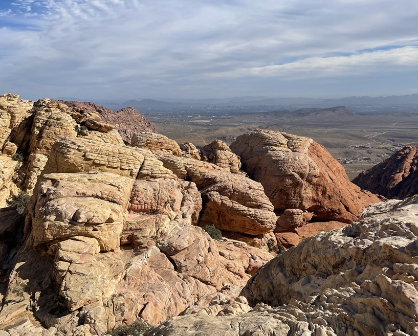
Cistern Spring is located downhill from Steamboat Geyser – I didn’t measure the elevation change, but it’s at least 50 feet lower, and the boardwalk trail has a couple of switchbacks. However, Cistern Spring is connected underground to Steamboat because it empties completely whenever the larger geyser erupts. The brown, green, and orange colors in Cistern Spring are created by different species of thermophiles. The dead trees around the spring were killed by the silica in Cistern Spring’s water: conditions around the spring were once healthy enough for the trees to germinate, grow, and mature, but then the conditions changed. We saw that a lot all over Yellowstone National Park: big areas of trees that had been killed by changing hydrothermal features.This feature has one of the best names in the Back Basin. It’s Black PitSpring, and it started off about half a century ago as a group of steam vents. Water now continuously bubbles with very small eruptions at its surface.Here’s a closeup, using a telephoto lens, of the little eruptions from Black Pit Spring. It’s a pretty mesmerizing hydrothermal feature, with a great variety of colors (not so much black, though).This is Echinus (pr. e-KI-nus) Geyser, perhaps my favorite feature in the basin. It is named for its mineral deposits, which apparently look the spins of sea urchins (neither Nancy nor I are overly familiar with echinoderms like sea urchins, but we didn’t see anything that resembled sea urchin spines). The red color is due to high concentrations of iron oxide (rust) in the feature. Echinus’s eruptions, which can reach 60 feet in the air, are unpredictable and are now months and even years apart. From 1878 to 1948, the geyser rarely erupted but then moved to periods of relative high activity alternating with dormancy. Prior to 1998, it was on an eruption schedule of about every half-hour to 90 minutes. The scientists believe that something happened underground in 1998 to affect the geyser’s water source. For now, it’s a fairly large and very pretty pool of water (see the guy emerging from the trees on the boardwalk just right of center for scale).This photo was taken on the other side of the geyser from where the previous photo was taken, i.e. just to the right of the guy on the boardwalk in the photo above. Echinus Geyser is a beautifully complex hydrothermal feature, even if we can’t make out the sea-urchin-ish spines.Here’s one of the reasons why Echinus Geyser appeals to me so much: these are terrace formations on the geyser’s southwest side where water leaves the geyser. I took this photo at about the same spot as the photo above, but used my telephoto lens again. These terrace mats are formed by unthinkably large numbers of a microorganism called Archaea (pr. aar-KEE-ah), which is a an immense domain of life that precedes kingdoms (you remember, from high-school biology, the memory aid “Kings Play Chess On Fine Green Sand,” or Kingdom, Phylum, Class, Order, Family, Genus, Species; domain is a step above kingdom). Water coming from the geyser is 176.5 degrees F (80.3 degrees C), and has a pH of 3.3 to 3.6 – it’s nearly as acidic as vinegar. At this point in the terracing, the temperature drops to between 140 and 160 degrees F (60 to 71 degrees C). Archaea absolutely love this hot and acidic water, and survive on the energy produced by iron oxidizing in the geyser’s water then bind together to build these ridges, pools, and ripples. Archaea are very common in nature: different types are found everywhere on the planet, including other features in Yellowstone National Park, and your gut, mouth, and skin are covered in them right now (not the same ones in this picture; remember that Archaea covers a lot of different species, let alone all of the other Kings Playing Chess). It’s extremely likely that when the scientists do find irrefutable evidence of extraterrestrial life, it will be in the form of Archaea or something close to it. This is a view a little further down the boardwalk from Echinus Geyser. That small river of water is flowing northwesterly from the geyser – it’s a pretty desolate landscape in the river bottom, but remember that the river has a pH nearly equal to that of vinegar. Notice also the steam rising from the ground where the river meets the trees in upper left; as the scientists say, this is a geothermally active area, and that is evidence of yet another geothermal feature.This is Porkchop Geyser, so named because of its shape when viewed from above and which only intermittently erupted until 1985 when it started spouting on a continuous basis. Those eruptions wasn’t enough to keep the geyser’s constriction from building up tremendous pressure and four years later, on Sept. 5, 1989, this feature exploded with a violence sufficient to throw large rocks more than 200 feet (61m). Fortunately, the tourists present for this surprise event weren’t injured. Porkchop’s vent hole at times has been the diameter of a garden hose; after the explosion, it’s about 7 feet in diameter. After that event, Porkchop became a gently bubbling hot spring with only occasional – and unpredictable – geyser eruptions.Even if it didn’t erupt while we were there, Veteran Geyser was a lot of fun to listen to. The area in shadow in the lower right corner of the picture is a vent through which Veteran exhaled with what sounded like someone in severe respiratory distress. A couple with whom I’d briefly spoken at Steamboat was here admiring Veteran as well, and, realizing that we were nearing the end of the Back Basin loop, the woman asked what our favorite hydrothermal feature was. I quickly answered with Echinus Geyser, and asked what her favorite was. She said it was Black Pit Spring, but mostly because of the name. I couldn’t disagree with her. In a basin filled with features named Green Dragon Spring, Puff ‘n Stuff Geyser, and Black Hermit Caldron, Black Pit Spring does still manage to stand out.At the time when Yellowstone’s visitors toured via stagecoaches, Minute Geyser erupted every 60 seconds to heights of 40 to 50 feet (12-15 meters). Inexplicably, many of those tourists tossed rocks into one of the geyser’s vents and eventually plugged it. While it continuously spouts water about 3 feet (0.9 meter) now, it’s unknown whether the feature will ever fully erupt again. Signs warning tourists to not throw rocks, coins, or other objects into park’s hydrothermal features were all over Yellowstone. I just can’t wrap my head around why someone would want to do that in the first place.The Back Basin loop trail ends with a short hike up a hillside, resulting in this magnificent view of Norris’s other geyser area, the Porcelain Basin. I’ve got pictures of the features within Porcelain Basin as well, and will post those in the near future.
There are about 25 named features within Back Basin, so this was a look at less than half of what’s there. Walking around any of Yellowstone National Park’s hydrothermal areas gets you really close to all kinds of aspects of our natural world, and it’s easy to think that it’s always looked the way it appears today. But conditions underground, like earthquakes, heat changes, mineral buildup, and more, ensure that these features are anything but timeless: a geyser can become a hot spring (and vice versa), for instance, because of subtle and usually unseen geologic changes.
It was a fun day at Norris’s Back Basin, and one that Nancy and I will appreciate for a long time – especially because the next time we go, it may be significantly different.
Works Consulted
Lynne, Bridget Y. “The Geothermal Guide to Yellowstone National Park.” 2017.
National Park Service. “Norris Geyser Basin Trail Guide.” March 2024.
National Park Service interpretive signage at features throughout Back Basin.
Wikipedia, articles on Archaea, Echinus Geyser, and Steamboat Geyser. Accessed September 2025. If you use Wikipedia, please support it.
September 28, 2024 – Near Pagosa Springs, Colorado
At the entrance to Chimney Rock National Monument, one can see Chimney Rock (center horizon), Companion Rock (to the left of Chimney Rock), and the mesa on which an ancient Puebloan great house still stands (at far left).
The scientific pursuits of geology, archeology, and astronomy combine in a number of interesting ways at Chimney Rock National Monument, located about 20 miles of Pagosa Springs in southwestern Colorado. In late September 2024, the Goddard was parked for a couple of weeks in Pagosa Springs, allowing us to enjoy the spectacular fall colors of aspen trees as well as a visit to Chimney Rock National Monument. We joined a geology-focused tour of the monument led by a volunteer guide, a former geologist in the oil and gas industry. In addition to learning about the rock features of the monument, we also learned about the history of the human habitation of Chimney Rock and visited the highest-in-elevation ancient Pueblo in the American Southwest, the Great House.
I took this photo from the road entrance to Chimney Rock National Monument using a telephoto lens. For perspective, Chimney Rock on the right rises more than 300 feet above the dark gray shale layer below it.
Between the years 925 and 1125, more than 2,000 Pueblo Native Americans lived in the Chimney Rock region and, although no more than about 250 people called it home at one time, they made it a substantial settlement for two centuries. The inhabitants built a number of stone and timber structures that are still standing today, and they traded goods with other Pueblo communities up to 150 miles away. Today, archaeologists know of 200 ancient structures collected within eight distinct villages at Chimney Rock.
Initial archeological investigations began in the 1920s by J.A. Jeançon, a Smithsonian Institution-trained archeologist working on behalf of the Colorado Historical Society, and his assistant, Frank Roberts; they and their crew surveyed and mapped dozens of structures and found thousands of artifacts.
Today, the U.S. Forest Service, which manages Chimney Rock National Monument, is leaving many archeological sites undisturbed out of respect for existing Puebloan and other Native American cultures, and with the understanding that less-invasive archeological techniques may be developed in the future. More than two dozen Native American tribes have an affiliation with Chimney Rock.
The monument, surrounded by the Southern Ute Indian Reservation, is closed to the general public each year from September 30 to May 15. The closure allows Native Americans to access the site for private ceremonial purposes, and the Chimney Rock area is also a major thoroughfare for elk migration.
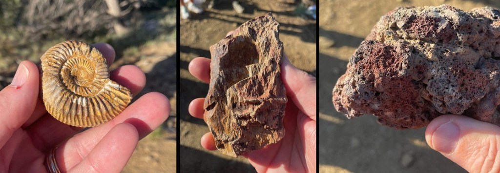
Geology! These three rocks, all of which were collected earlier at Chimney Rock by the volunteer geologist conducting our tour, tell a really interesting part of the story of the area. The ammonite fossil at far left shows that Chimney Rock, which today gets about 14 inches of precipitation annually, was once covered by an inland sea. Ammonites were incredibly diverse and numerous aquatic cephalopods (related to modern squid and octopi) that flourished for hundreds of millions of years until the Earth’s collision with an asteroid 65 million years ago. The petrified wood in the center indicates that large trees used to grow on shorelines left when the land rose and the sea receded. Finally, the basalt at right was ejected from an erupting volcano in the area. (Yes, I know the ammonite photo also demonstrates that I was, at the time, in gruesomely desperate need of my semi-annual mani-pedi.)
The true importance of Chimney Rock lies, of course, in its ties to ancient and current-day Native Americans. But from a geologic perspective, the story of Chimney Rock begins, seemingly as do so many on this website, with a great inland sea. One hundred million years ago, much of present-day North America was under a shallow but vast sea that connected the Gulf of Mexico to the Arctic Ocean. At its largest size, the Western Interior Seaway stretched from today’s Rocky Mountains in the west to the Appalachian range in the east. At its deepest points, it was only about 3,000 feet from the waves on top to the sea bottom – very shallow for a sea. The size of the sea varied widely over the course of its 34 million years of existence; it finally drained away for good about the time of the end of the Cretaceous Period, or 65 million years ago when dinosaurs ceased to rule the earth.
While it was relatively shallow, the Western Interior Seaway’s 3,000 feet of water depth carried a lot of compression capability. Clay at the bottom of the sea, as well as dead plants and animals, accumulated over the eons to build a 1,000-feet-thick layer of mud. That layer would solidify, over millions of years of water weight pressing upon it, into a dark gray layer of rock called Lewis Shale. When the western part of the American continent began to rise, the waters of the inland sea drained away to leave shorelines of sand and tidal flats. Dry periods alternated with years upon years of wetter conditions, leaving layers of coal and fossilized animal skeletons.
About 40 million years ago – 26 million years after an asteroid impact killed all of the non-flying dinosaurs as well as a goodly amount of other life on Earth – volcanoes began erupting in the Four Corners area of Colorado, Utah, New Mexico, and Arizona. This activity built the Colorado Plateau, a huge high-desert expanse of the southwestern United States covering 130,000 square miles of those four states, roughly centered in the Four Corners area.
The erosional forces of wind and water began to have their way with the soil covering today’s Companion Rock and Chimney Rock, and then glaciers from the last Ice Age of 4 million years ago carved deeply into the former mud of the inland seafloor, now compressed into shale. Finally, the glaciers melted and the resulting floodwaters exposed sandstone – formerly the beaches of the receding inland sea from tens of millions of years earlier but compressed into a rocky layer – and eroded away nearly all of that sandstone layer with the exception of Companion Rock and Chimney Rock. The scientists believe that the two sandstone features have been exposed for about 25,000 years, protected by what was probably the thickest and hardest layer of sand during the time of the Western Interior Seaway and is now a layer of sandstone more resistant to erosion than other rocks had been. However, they too, with the relentless work of water and wind, will gradually fall to the valley below.
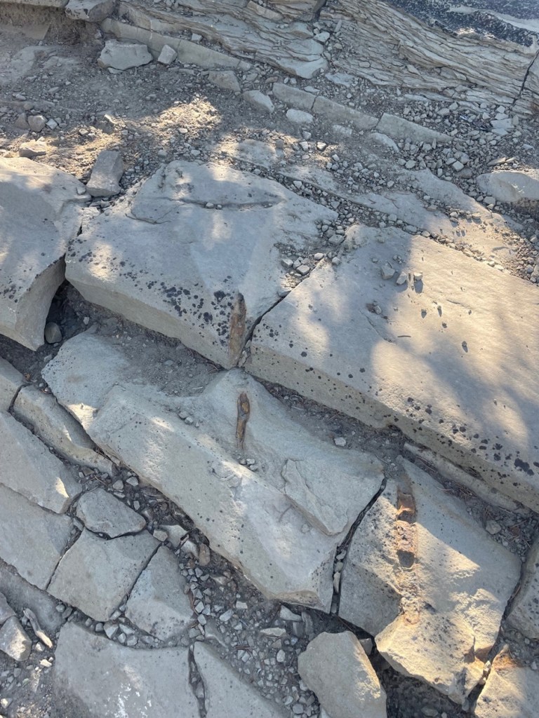
This view, looking east on a hazy late-September morning, shows the dark-gray Lewis Shale layer below the light-brown Pictured Cliffs Sandstone layer, of which Companion Rock and Chimney Rock are the tallest remnants. This valley was carved by glaciers and the flooding of the melted glaciers as well as the Piedra River. To the immediate left of the two natural rock towers is the Great House, built by ancient Puebloans . The San Juan mountains, volcanic in origin, are on the far horizon.This is the trail leading to the monument’s Great House, one of the square exterior corners of which can be seen at the top of the photo. This is the same trail that was used by the ancient Puebloans to make their way from the valley floor to the Great House. The trail is situated on a relatively thin ridge of sandstone. Everything brought to the Great House – building materials, foodstuffs, water – was carried by the ancient Puebloans, by hand, up this trail.These sandstone rocks are on the trail to the monument’s Great House. Our geologist guide noted that the natural fracturing of the sandstone made selection and collection of the rocks much easier for the Puebloan builders of the structures in the monument. Note also the brownish markings in the rocks: they’re about 6-8 inches long, and are the fossilized burrows of a prehistoric crustacean that lived in the sand of the inland sea that once inundated much of North America. The animals dug these burrows into the existing shoreline sand, and the holes gradually filled with clay and mud containing iron to leave behind the brown fossils seen on the trail today.Archeology! This south-facing exterior wall of the Great House has an interesting story. Most of the rocks comprising the Great House and other structures were replaced, in place, over the last century by archeologists and during a major project in the 1970s involving Native Americans. The structures had simply fallen victim to the forces of erosion over the course of 10 centuries of non-occupancy. However, the modern-day wooden shelf in the center of this photo is protecting part of a stone wall that was laid by Puebloan hands a thousand years ago and managed to stay intact. Note the different size and color of the rocks surrounding the original work.The rock formations are still quite a good distance from the Great House; Chimney Rock itself is 315 feet tall. Scientific analysis of some of the wood beams still left at the Great House shows that construction began in the year AD 1076 and then expanded in AD 1093. Those particular years would prove to be significant in discovering why Great House was built where it was.This picture was taken looking southwest from atop one of the Great House’s walls. Many of the rocks in the walls have been replaced over the years, but some parts of the walls feature the original masonry and stonework. It’s estimated that the Great House was built using up to six million stones, all of which were hand-selected, hand-shaped, and hand-carried to this site. All of these walls were once taller, and roofs covered the buildings. On the far horizon, in the center of the photo and between the left and right hillsides, lies New Mexico. Visitors from Chaco Canyon, 90 miles away, would approach the Chimney Rock villages through that low valley. Similarities between the architectural styles of the buildings at Chaco Canyon and Chimney Rock, as well as those of cultural artifacts, such as pottery designs, stone tools, and projectile points, demonstrate that the two communities shared many ideas over the two centuries of Chimney Rock’s existence. Similar artifacts show that the residents of Chimney Rock may have traded with still other Native Americans living up to 150 miles away.
Jeançon began his excavation of the Great House Pueblo in 1921. He noted that some of the walls were still 14 feet tall. The building contained at least 35 rooms and two kivas, the round structures believed to be the center of the ancient Puebloans’ spiritual and perhaps social lives. An archeologist has estimated that to build a structure of this size and complexity, in addition to the 6 million rocks, the builders would have needed 5,000 log beams, 25,000 tons of water, and 25,000 tons of dirt to make an adobe mortar. All of these materials would have had to have been carried up the steep trail by hand.
Considering all of the labor needed to build Great House and the many other structures, one is left with the question of why the residents stayed here for only two centuries. There are three prevailing hypotheses for the ancient Puebloans’ departure: it’s possible that the area was depleted of food and other resources; societal changes or perhaps warfare made it in the residents’ best interests to leave; or the community, representative of other Puebloan cultures of the time, simply decided that it was time to find a new home. Whatever the reason for their departure, it’s believed that the residents of Chimney Rock, along with many other ancient Puebloan communities, moved south into present-day New Mexico and Arizona; their descendants can be found today among the members of the Navajo, Hopi, Zuni, and other Native American tribes.
While at the Great House, I took a picture of Companion and Chimney rocks with my telephoto lens. The distance from the Great House to the rock formations makes them look smaller than they actually are; as I noted earlier, Chimney Rock, the structure furthest away, is taller than a football field is long. The top of Companion Rock is a nesting area for peregrine falcons. Because of their spiritual significance to Native Americans and to protect the birds’ nests, both rock formations are off-limits to hikers and rock climbers.
That covers some of the geology and archeology at Chimney Rock National Monument; let’s move on to the skies above. Nancy and I learned a new word the day we visited the monument: archeoastronomy. This vowel-heavy construction refers to the study of the ways in which ancient cultures studied the skies and how they used that information to guide many of their day-to-day and seasonal decisions, including when to plant crops and conduct spiritual ceremonies. Around the world, very old cultural sites, like Stonehenge in England and hundreds of temples in Egypt, show that ancient peoples were keenly aware of the movement of the sun, moon, planets, and stars.
Observing the skies and the objects contained in the vast expanse above also played a major role in the ancient Native Americans’ religious lives. In North America, evidence of the significance of celestial movement to Native American cultures can be found in many places, including at Chaco Canyon and at Chimney Rock.
The most significant alignment of celestial objects and Earth-bound structures at Chimney Rock is known as the Northern Major Lunar Standstill. (That was another term and concept new to Nancy and me, neither of whom are anywhere close to unfamiliar with astronomy, but I guess that’s a big reason that we’re doing this: each time Nancy and I leave the Goddard to visit a museum or national park, we ask each other, “Are you ready to do some more learnin’?”)
Many will be aware that the rising and setting of the sun appears to move across the horizon as the year progresses: on the day of the summer solstice it appears to rise and set in its northernmost latitude (and makes for the longest day of the year in the northern hemisphere), and then the sunrise and sunset appear to occur further south each day until the winter solstice, making for the shortest day of the year. It then appears to move north again to complete the second half of the solar cycle.
The moon has a similar cycle, appearing to rise at different locations from north to south like a pendulum over the course of a month. The Northern Major Lunar Standstill, or MLS, occurs on a recurring cycle of 18.6 years when that pendulum of the moon’s rise appears to stay in the same location on the horizon for a period lasting about 16 months.
Here’s the significance of the MLS to the manmade and natural stone structures at Chimney Rock: during the lunar standstill and when viewed from the Great House Pueblo, the moon appears to rise between Companion Rock and Chimney Rock. Archeoastronomers don’t know this for an absolute certainty, but it appears that the Great House was built where it was so that its ancient Puebloan residents could observe this event that occurs on a cycle of just under two decades. The years AD 1076 and 1093, when the structure was built and later expanded, were both years in which lunar standstills occurred. It’s quite possible that many ancient Puebloans from around the Four Corners region traveled to the Great House to view this powerful spectacle alongside the residents of Chimney Rock.
As it happens, in late 2024 the MLS was nearing the end of its cycle at Chimney Rock – our U.S. Forest Service geologist guide showed us pictures on his cellphone he’d taken of the moon rising between the two rocks just a few nights before our visit. We briefly lamented not being able to see the event ourselves, but the guide noted that very few people are allowed to be at the Great House at night. It’s of extraordinarily powerful spiritual significance to modern Puebloans, of course; it’s also incredibly dangerous to walk the trail to the Great House at night because of the trail’s position on a very thin ridge. The Forest Service and its academic partners in astronomy have a camera situated at the Great House, and the transmission showing the moon’s rise between Companion Rock and Chimney Rock is seen by many people down at the monument’s visitor center.
I’ve long had an affinity for this wildflower, desert paintbrush, so I was happy to see this specimen blooming just a few steps from the Great House.Astronomy, again! While researching the information for this posting, I happened to notice that the Griffith Observatory, based in Los Angeles, was hosting a livestream of the moonrise from Chimney Rock on the evening of October 21, 2024. Nancy and I were very happy to watch this event from our living room in the Goddard as it was parked in Flagstaff, Arizona, three weeks after our visit to Chimney Rock National Monument. To sum up, we watched an astronomical observatory in southern California conduct a livestream of the moon rising between Companion Rock and Chimney Rock, 350 miles away from where it was happening in southwest Colorado while we were camping in northern Arizona. As I often say, we’re living in the future.
As we were walking away from my first viewing of the Grand Canyon, I turned to Nancy (who’d been to the national park on a hiking trip with friends some years earlier) and said, “I wasn’t prepared for that.”
And that was an understatement among understatements. I’d seen countless photos, as well as tons of video footage and movie clips, of this geologic wonder, and I was woefully unprepared for just how stunning the views are when one is actually standing on the rim of the Grand Canyon. More than a year later, while editing the photos for this blog posting, I am shaking my head at the images and believe me when I tell you: my photos don’t do the Grand Canyon justice and neither do anyone else’s.
“In the Grand Canyon there are thousands of gorges like that below Niagara Falls, and there are a thousand Yosemites. Yet all these canyons combine to form one grand canyon, the most sublime spectacle on the earth.”
– John Wesley Powell, 1895
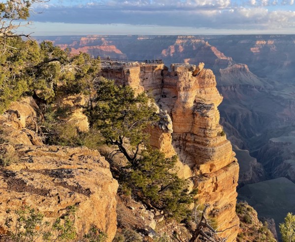
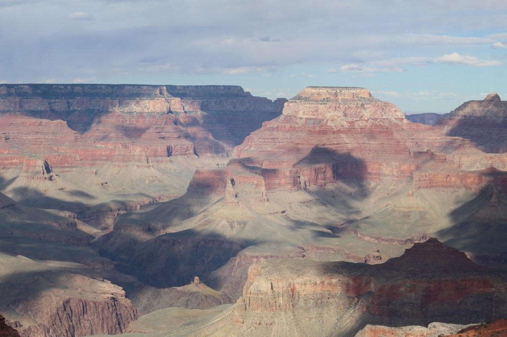
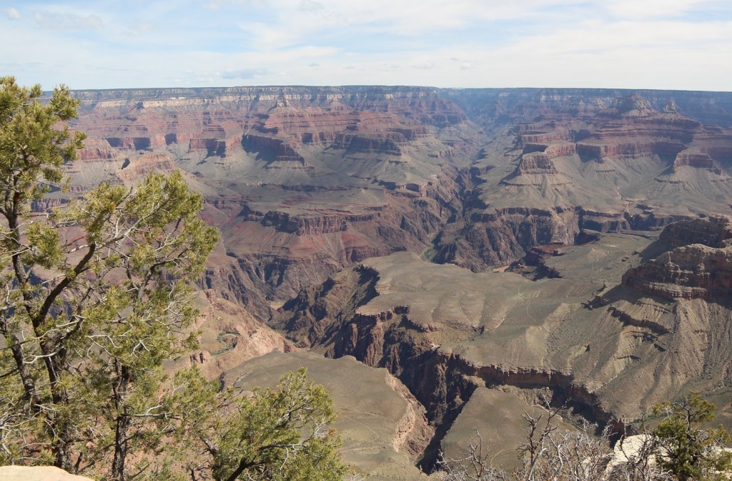
This is the first photo I took from the rim of the Grand Canyon. The views are so expansive, both in distance and depth, that the light from the sun and shadows from cloud cover change what you see from minute to minute. The average width of the canyon from the South Rim to the North Rim is 10 miles. The different colors in the rocks are due to the presence of varying minerals, such as iron oxide, in each layer.
Grand Canyon National Park: By The Numbers
Date established
January 11, 1908 (national monument); February 26, 1919 (national park)
Total area
1,902 square miles
Total visitors
4.73 million in 2023
Elevation
South Rim: 7,129 feet (elevation of North Rim is 8,145 feet); elevation of Colorado River is 2,400 feet
The Grand Canyon’s dimensions are so big that the numbers are related in miles, not feet. Consider that the state of Colorado measures 280 miles from its northern border with Wyoming to its southern border with New Mexico. The Grand Canyon, at 277 miles long, is only three miles shorter than that distance. The width of the canyon is an average of 10 miles. It’s nearly one mile – an average of 5,000 feet – from the rim of the canyon to the Colorado River below.
Here’s something about the Grand Canyon that I find really hard to fathom: the scientists believe that the canyon is only 6 million years old. In geologic time, that is less than the beginning of an eyeblink. Prior to the 1966 completion of Glen Canyon Dam, upriver from the Grand Canyon, during spring and summer runoff hundreds of thousands of tons of sediment would be carried by the Colorado River – each day. That water, pushing and pulling and tossing sand, gravel, rocks, and boulders through the canyon, gouged what is now a mile-deep course through what is now northern Arizona. The erosional forces also included precipitation and freezing and thawing of water along the canyon’s walls.
Early European-American residents of the American Southwest recognized that the Colorado River had to be tamed in order to prevent it from wiping away those resident’s properties during spring and summer floods. Creation of the national monument in 1908 and eventual designation of Grand Canyon National Park in 1919 assured that no manmade water diversion projects would be constructed within the boundaries of the park.
This is the second image I took of the Grand Canyon. The multicolored and clearly delineated rock layers, including sandstone, limestone, shale, schist, and others, range in age from 2 billion years old at the bottom of the canyon to 250 million years old at the top, nearly one mile above the Colorado River.
Beginning from Lees Ferry on the east to Grand Wash Cliffs on the west, the Grand Canyon measures 277 miles in length (at 280 miles, the state of Colorado is 3 miles longer from its northern to southern borders) . Two great manmade structures bounding the Grand Canyon, Glen Canyon Dam and Hoover Dam, create two immense reservoirs, Lake Powell and Lake Mead respectively, to manage the Colorado River’s water flow.
As it flows through the Grand Canyon, the Colorado River has an average depth of 35 feet and a width that varies from 76 feet to 300 feet. During normal operations of Glen Canyon Dam (and when the American Southwest isn’t enduring its ongoing decades-long drought), almost 130,000 gallons of water moves through the canyon’s inner gorge every second – enough to fill an Olympic-sized swimming pool in 5 seconds. The volume of water released through the canyon is often dependent on municipal electricity demands from cities as far away as Los Angeles. The Colorado River used to flow 1,450 miles from La Poudre Pass in Colorado’s Rocky Mountain National Park all the way to the Gulf of California; municipal and agricultural demands on the river in the southwestern United States cause the river to gradually dry out shortly after crossing into Mexico.
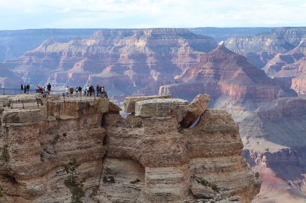
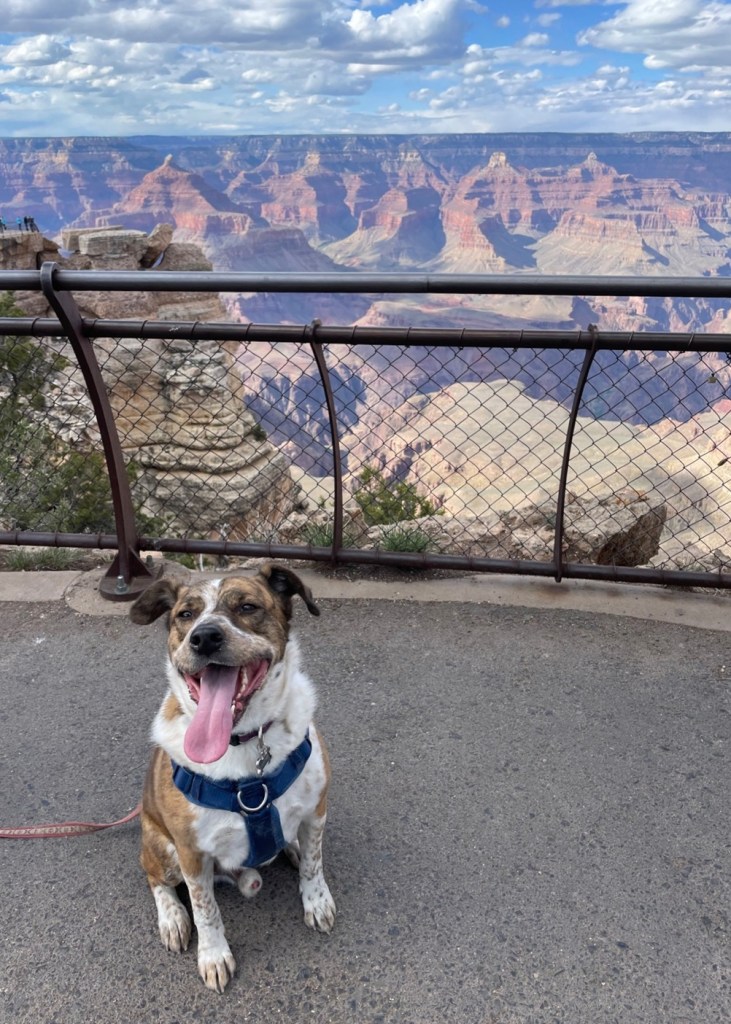
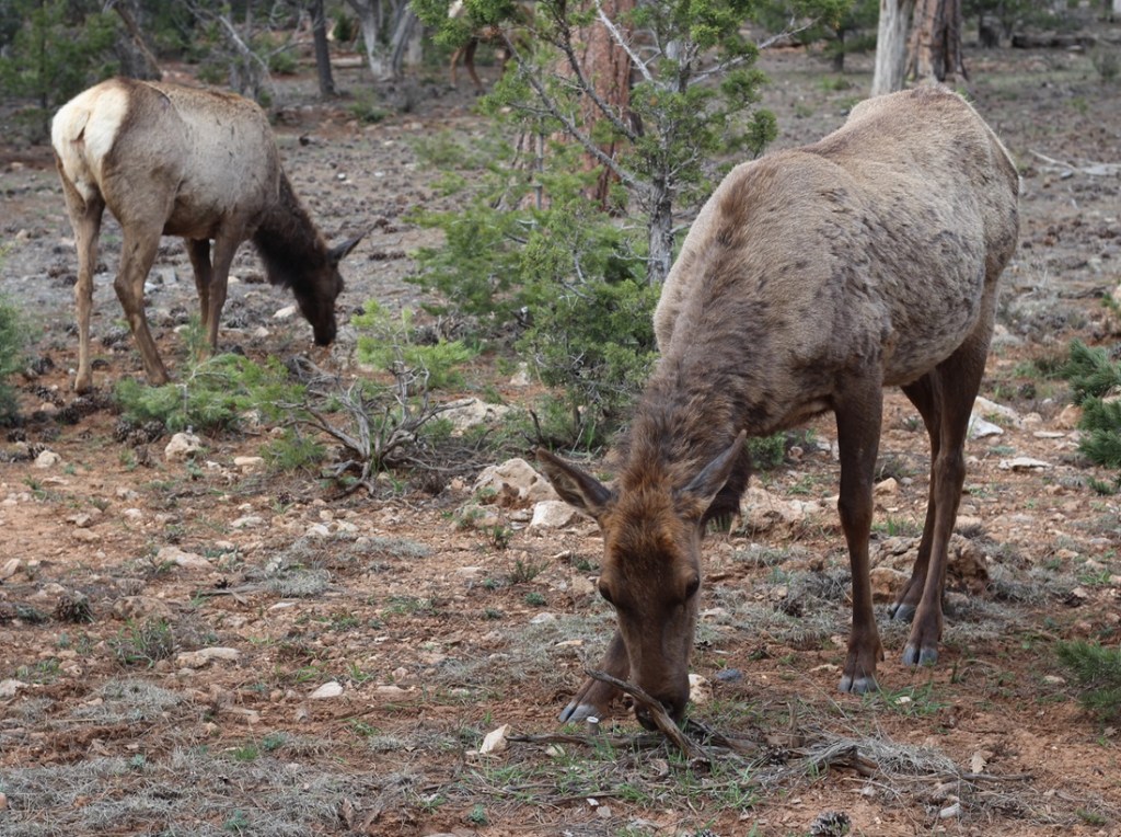
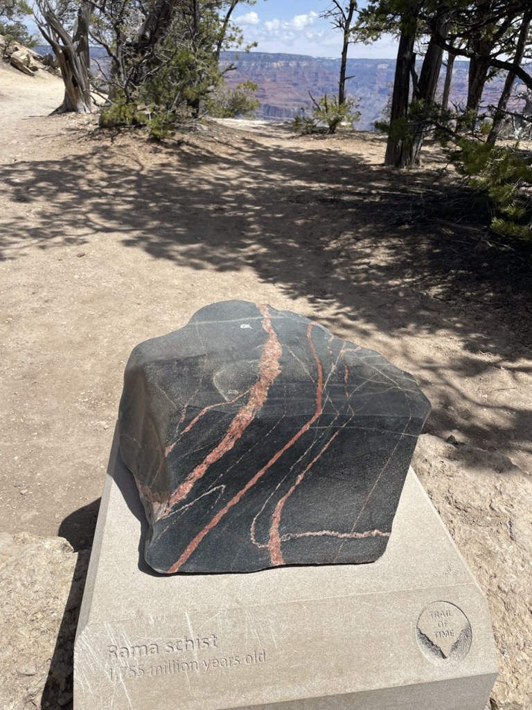
We’ve all seen plenty of canyons across the country and around the world, most of which are easily identifiable by the watercourse that originally carved them. But, in many places, the Colorado River isn’t visible from the rim of the Grand Canyon – there are too many smaller canyons, many of which would be significant geologic features on their own anywhere else – that block the view. The Grand Canyon is a supercanyon of canyons. (This is the third photo I took of the Grand Canyon, by the way. I took hundreds. I won’t post them all, I promise.)Here, then, is the fifth photo I took of the Grand Canyon. We weren’t the only visitors to the national park that day. This is a group of people at Mather Point, one of the larger overlooks that extends into the canyon. Clear days at Mather Point provide views of up to 30 miles to the east and 60 miles to the west. The overlook, along with a campground in the national park, is named after Stephen Tying Mather (1867-1930), the first director of the National Park Service.Here we see a visitor (it’s Gunther) to Grand Canyon who, like me, is experiencing his first few hours at the national park. Gunther was able to join us on our first visit to the canyon’s South Rim, which has a mostly paved walking trail extending 13 miles. That’s Mather Point in the left mid-background.At an elevation of 7,000 feet above sea level, the South Rim of the canyon features an extensive ponderosa pine forest. The campground in which we parked the Goddard was a very pleasant one-mile walk through this forest, which also includes Gambel oak, mountain mahogany, and elderberry shrubs, to the canyon. And there were elk in the forest. Lots and lots of elk. On a couple of occasions, we saw elk grazing perhaps 10 feet from our fifth-wheel home. Some local residents we met on the trail said the elk, just prior to big-game hunting season in the fall, have an uncanny ability to move from the Kaibab National Forest into the protected lands of Grand Canyon National Park.I took this photo with a wide-angle lens in a vain attempt to capture some of the vistas from the rim of the Grand Canyon. This is looking west-northwest further west from the Visitor Center, down the park’s Rim Trail. In the direct middle of the photograph is a light-brown spot, at the bottom of the canyon. Yep, that’s the Colorado River, a mile below the rim and probably two miles north of this viewpoint. The temperatures at the bottom of the canyon are typically 30 degrees higher than at the rim.The Rim Trail, which follows 13 miles of the South Rim, has a pretty nifty display called the Trail of Time in which millions (and billions) of years of the earth’s existence are represented by steps on the 1.5-mile section of trail. The intent is to illustrate the incredible amounts of time that are represented by the different types of rocks found in the canyon, with more than a dozen clearly defined layers from top to bottom of the canyon. The further along the Trail of Time you walk, the (figuratively) further back in time you go. Along the way are representative rocks from the different depths of the Grand Canyon. Pictured here is a pretty sample called Rama Schist, which is from a part of the canyon that’s just under 1.8 million years old. Geologists believe that the Colorado River began forming the Grand Canyon by carving through the 250-million-year-old Kaibab Plateau layer about 6 million years ago, meaning the canyon is only 2.4 percent as old as even its uppermost (and youngest) rock layer. Since then, it has only carved deeper and the canyon is now a mile deep – although its erosional power has been greatly reduced by manmade dams upriver.Here’s another view. looking west-northwest again, a little further down the Rim Trail. The mighty Colorado, still a light brown smudge, is in the lower right corner of this image. I was not expecting so much tree growth at the top of the canyon, but the Rim Trail is heavily shaded for long stretches.
The South Rim of the Grand Canyon receives about 15 inches of precipitation annually, while the North Rim receives just over two feet. The winter of 2022-2023 was an exception, at least for the North Rim. While we were at the South Rim in late April 2023, there was still snow visible on some north-facing walls of the canyon. Because of huge amounts of snowfall during the winter of 2022-2023, the roads leading to the North Rim of the Grand Canyon wouldn’t open until early June.
One more wide-angle view, which depicts some the thousands of smaller canyons in the park that lead into the Grand Canyon. The Colorado River is visible in this image, just to the lower-left of center and to the right of the tree limbs.
The Grand Canyon was designated a UNESCO World Heritage Site in 1979. Those sites are deemed to contain “cultural and natural heritage around the world to be considered of outstanding value to humanity.” These sites must be unique, geographically and historically identifiable, have a special cultural or physical significance, and be under a system of legal protection. UNESCO World Heritage Sites can be ancient ruins, deserts, islands, mountains, wilderness areas, and other natural or manmade features. As of July 2024, UNESCO had recognized just over 1,200 World Heritage Sites; Mesa Verde in Colorado and Yellowstone in Wyoming are examples of other U.S. national parks that are also UNESCO World Heritage Sites.
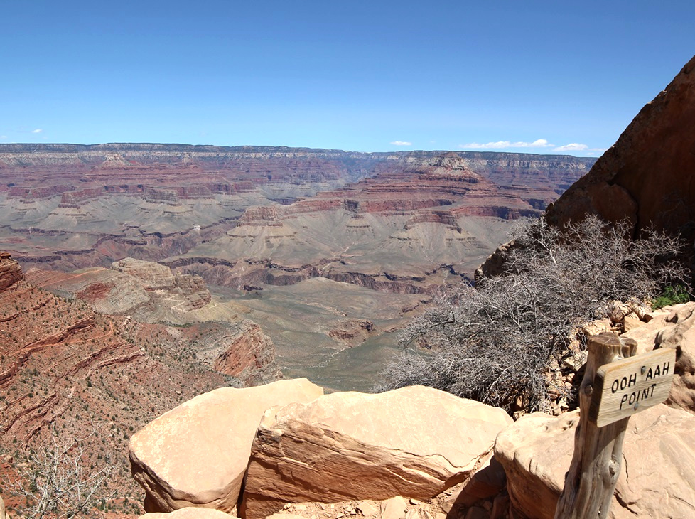
Leaving Gunther at home for a few hours one day, Nancy and I went on a great hike down into the canyon on the South Kaibab Trail to see this view looking across the eastern Grand Canyon. The sign at lower right indicates viewers’ usual reactions.Here we see an intrepid hiker (it’s Nancy) making her way from Ooh Aah Point, beginning the return to the canyon rim on the South Kaibab Trail. This view is looking north.This view, from a point about as far west as we walked on the Rim Trail, is looking east toward the Visitor Center. The zig-zagging line at the bottom of the image is the Bright Angel trail, which Nancy hiked with friends some years ago. It’s an aggressive hike.One more view of the Mather Point overlook: on the morning of April 25, 2023, Nancy and Gunther and I got up early to watch the sunrise at Grand Canyon National Park. The low angle of the dawn’s rays gave the canyon’s features added depth and still more colors that we hadn’t yet seen. This is nearly the same perspective as the fourth photograph in this blog, but compare the coloration and shadows between the two images. The sun has risen on this landscape 2.2 billion times since the Colorado River began carving the canyon. This was just one of those times, but it was still spectacular.
If you’ve been to Grand Canyon National Park, you know this: it’s a must-see park; if you haven’t been, know this: you must see it. The views are simply unmatched, at least in my experience, and the hiking opportunities range from level and paved trails to “park rangers may not be able to come rescue you,” with everything in between.
For such a recent addition to the Earth’s surface (seriously, 6 million years of erosion on this planet is absolutely nothing in the grand scheme of things), the Grand Canyon is an amazing spectacle that really has to be seen in person to get a full appreciation of its beauty. As much as I’ve gone on and on about it, you won’t be prepared when you see it, either.
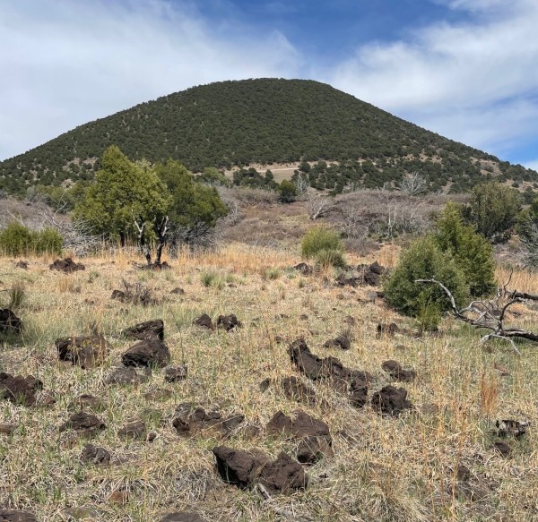
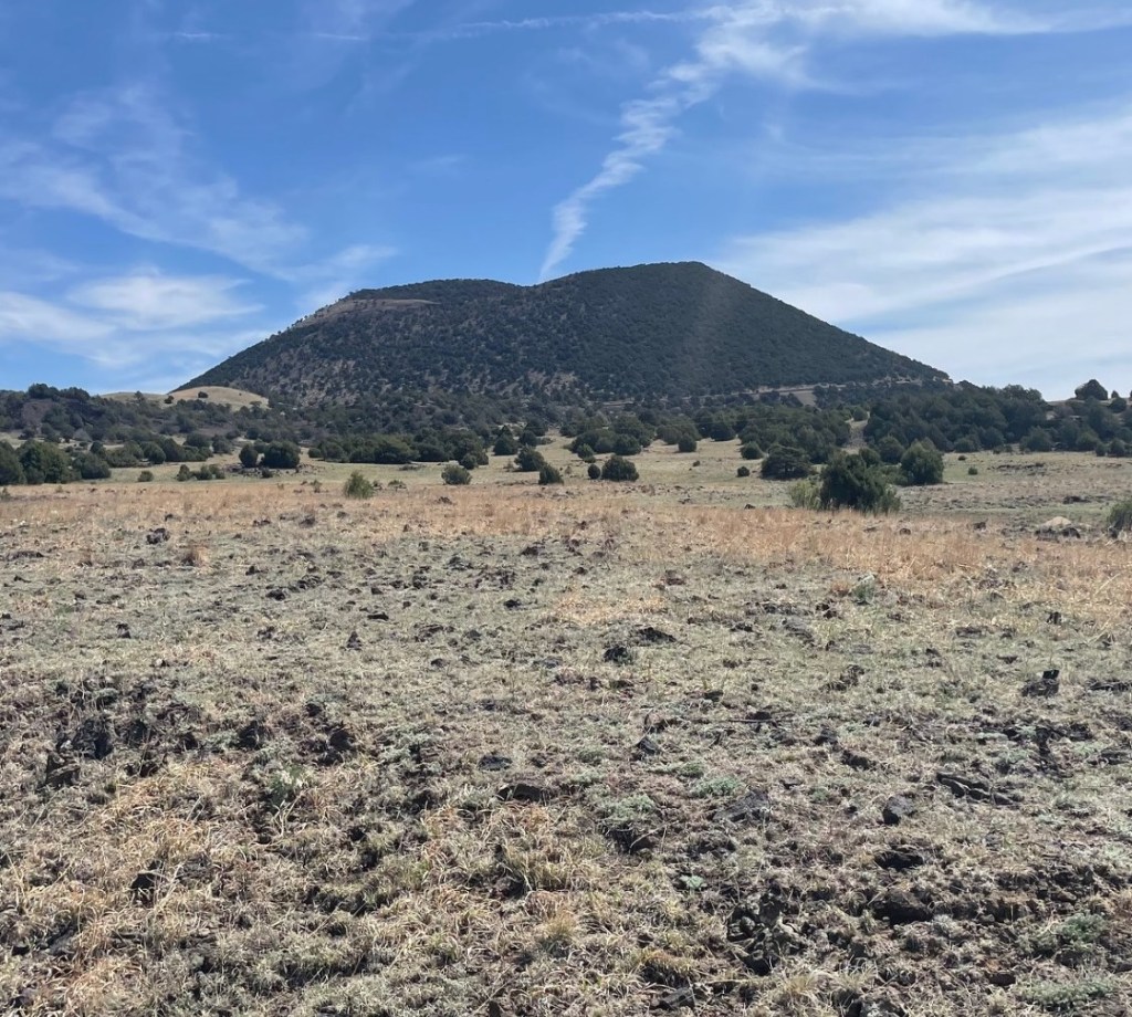
Our country’s national monuments and parks provide opportunities to appreciate nature in a variety of forms: mountains and cliffs, seashores and inland beaches, forests and grasslands, along with the animals, plants, and rocks that provide those landscapes with so much interest. The really good monuments and parks, however, present those opportunities along with an introduction to the cultural forces that helped shape them as well. Despite its small size, Capulin Volcano National Monument in far northeastern New Mexico (it’s less than 20 miles south of the border with Colorado) is a shining example of the best that the National Park Service has to offer.
The 1.25-square mile national monument is located in the Raton-Clayton Volcanic Field, an eight-thousand-square-mile area containing dozens upon dozens of volcanos that erupted over the last nine million years. We visited Capulin Volcano National Monument, featuring the region’s best-known volcano, during our stay in Raton, New Mexico, in May, 2024
This is a region where the grasslands meet the mountains – the Great Plains end and the Rocky Mountains begin. Along with its relatively recently created cinder cone volcano, Capulin (pr. kah-poo-LEEN), the monument preserves an incredibly diverse environment for plants and animals, and interprets the area’s human influence extraordinarily well. This is an area through which a great many people passed, whether they were on foot pursuing giant Ice-Age mammals in search of food, in horse-drawn wagons making their way from Missouri to New Mexico on the Santa Fe Trail, or on horseback following great herds of cattle on their way from Texas to northern pasturelands and railroads.
But let’s forget about people for a while and talk about volcanoes. Just below the now-quiet surface of the Raton-Clayton Volcanic Field, the Earth’s crust is relatively thin and unstable, so, in the distant past, magma roiling near the surface of the planet made its way upward in a variety of ways. Volcanic features are everywhere you look in the region: it’s home to about 125 cinder cones, volcanic necks, and a single shield volcano. Chances are that if a geologic structure rises higher than the surrounding grassland, it was once an active volcano.
The cinder cone of Capulin Volcano rises almost 1,300 feet – about the height of New York City’s Empire State Building – above the northeastern New Mexico plains . The crater’s rim measures about a mile in circumference, and the crater itself drops 400 feet below the rim. The highest point on the volcano is 8,142 feet above sea level, and standing at different points on that rim affords views not only of a goodly part of New Mexico, but of Colorado, Oklahoma, and Texas as well (they all kind of look the same, to be honest – someone should probably repaint the states’ borderlines).
Erupting about 60,000 years ago, Capulin is the youngest large volcano in the Raton-Clayton Volcanic Field. Geologists consider Capulin extinct, but the rest of the field is considered only dormant and the potential exists for additional volcanic activity in the future. Considering, however, that Capulin erupted that long ago, it’s unlikely that we’ll see anything happening anytime soon.
Capulin Volcano National Monument: By The Numbers
Date established as a national monument
August 9, 1916
Total area
793 acres (1.25 square miles)
Yearly visitors
67,000
Highest point
8,142 feet (top of cinder cone)
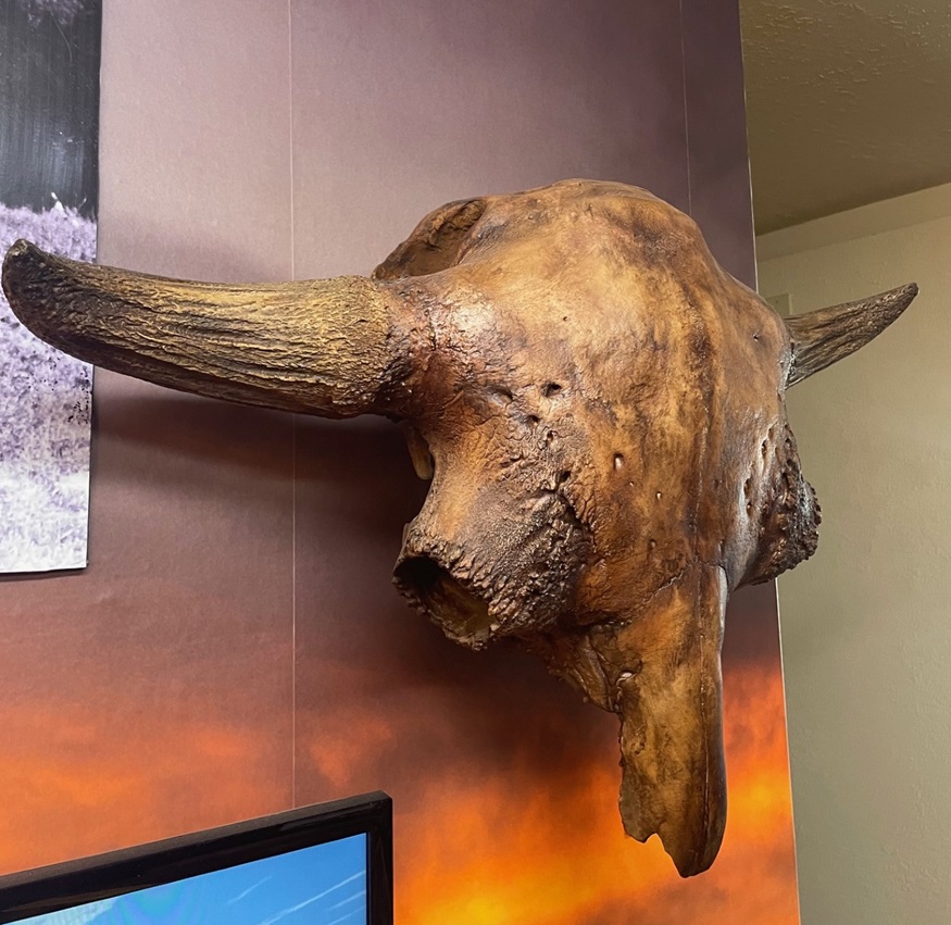
The monument has a very fine visitor center with a number of interesting displays that explain the geological, biological, and cultural history of the area. This is a recreation of the skull of a Bison antiquus, which lived in the region about 10,000 years ago during the Pleistocene Epoch . They were about 30 percent larger than modern-day bison (and I don’t know how close you’ve been to a bison, but they’re pretty good-sized themselves; bulls regularly weigh more than 2,000 pounds). Fossilized bones from Bison antiquus were first discovered in 1908 by George McJunkin, a former Black slave who became a bronco-busting and bilingual ranch hand in New Mexico. That find would become one of the most important archeological discoveries in the nation’s history. McJunkin was inspecting pasture conditions following a torrential rainstorm when he happened upon the fossils. He knew he’d discovered something important, but couldn’t get any experts interested in the discovery and he died in 1922 without realizing exactly what he’d found. In 1927, an expedition from the Denver Museum of Natural History (now Denver Museum of Nature and Science) found, in the same area, fossils of the same species. However, those newly discovered fossils had projectile points embedded in them, which proved that humans lived in this area during the Ice Age – about 7,000 years earlier than first believed. The projectile points and the native American culture that used them were named after the New Mexico town near where they were discovered: Folsom, which is about six miles north of Capulin Volcano National Monument.Located where the northeastern New Mexico grasslands meet the Sangre De Cristo mountain range, Capulin Volcano National Monument provides habitat for a wide variety of wildlife. Spotted towhees (Pipilo maculatus) were by far the most plentiful birds we saw while visiting Capulin, but the national monument is home, either year-round or for migratory stopovers, to more than 70 bird species. Spotted towhees are more commonly seen on the ground, scratching through leaf litter in search of insects, but in the springtime males especially will make their way to the tops of shrubs to let loose with their pretty call. This fellow was hanging out near the parking lot on the crater’s rim.
After enjoying the visitor center, Nancy and I drove the Goddard’s six-wheeled towing unit up a road that spirals around and up the Capulin cinder cone. It’s an interesting drive that brought us to a small-ish parking lot at the top of the crater, with a trailhead for the one-mile Crater Rim loop. The easy hike provides great views of the Raton-Clayton Volcanic Field, and many of its geologic features.
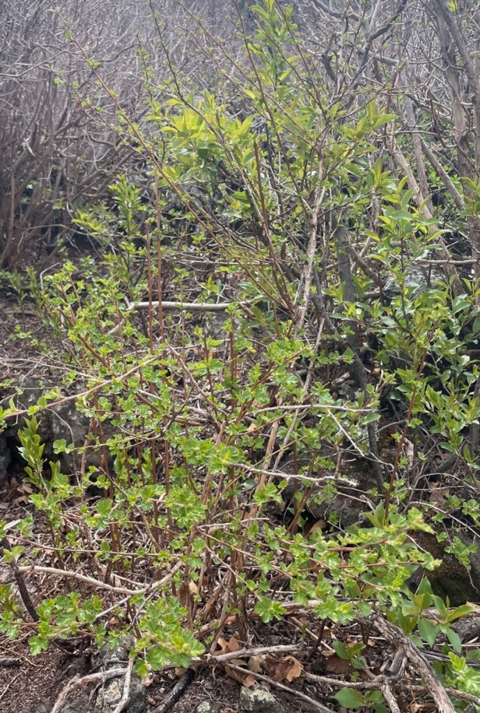
During its 10-year-long eruption history, Capulin ejected volcanic ash as well as small gravel-sized cinders and larger rocks, called bombs, thousands of feet into the sky. In all, the ejected material covered almost 16 square miles of what is now New Mexico. The cinders, which measure 2-64 millimeters in size, built the majority of the cone’s structure by falling back to earth and piling up around the eruption site. Volcanic bombs measure in excess of 64 millimeters (2.5 inches). Upon its return to the ground, this bomb, roughly the size of a car engine block, landed on the rim of the crater. This spot, then, would have been a good one to avoid at the time. The western side of the rim (where the parking lot is located) is about 300 feet lower than the opposite side; the scientists believe that’s due to wind gusts picking up cinders and then dropping them while Capulin was erupting. The Goddard’s six-wheeled towing unit can be seen on the right side of the parking lot on the other side of the rim. On the left side of the photo, on the farthest horizon, you can see the snow-capped Spanish Peaks, located a few miles west of Walsenburg, Colorado. We’d move the Goddard to camp at Lathrop State Park, very close to the Spanish Peaks, following our stay in Raton. This is a variety of chokecherry (Prunus virginiana), a large shrub or short tree that was formerly found all over the volcano but now grows primarily in the crater. It blooms between April and June, and its fruit is used for jellies and teas. Spanish-speaking ranchers who settled in this area called it by its Spanish name, “capulin.”Viewed here looking southeast from the rim of Capulin, Sierra Grande (elev. 8,720 ft.) is the only shield volcano as well as the largest volcano in the Raton-Clayton Volcanic Field. Rather than an eruption of ash, cinders, and lava rocks, the mountain was made over the course of many fluid lava flows from 3.8 to 2.6 million years ago. The panhandle of Oklahoma is about 50 miles east of Sierra Grande (to the left in this image). The ripples in the land between Sierra Grande and Capulin are called pressure ridges; they’re formed when flowing lava on the surface begins to cool while hotter lava continues to move underneath the hardened rock.From 1821 until 1880, the Santa Fe Trail connected Independence, Missouri, with Santa Fe, New Mexico. Traders, settlers, and the military used the trail to move through what was then the homeland of several different native American cultures, including the Comanche, Cheyenne, and Jicarilla Apache. This is looking east from the top of Capulin; the dark streak on the horizon on the left side of the image is Black Mesa, Oklahoma, about 80 miles from the volcano. When travelers heading west on the Santa Fe Trail saw geologic features like Black Mesa or Capulin, they knew they were approaching their destination in northern New Mexico and their journey across the Great Plains was nearing an end.This pretty yellow flower, prairie thermopsis (Thermopsis rhombifolia), was growing next to the Rim Trail on Capulin. It is one of the first flowers to blossom in the national monument each spring.
Charles Goodnight and Oliver Loving, two Texas cattlemen, wintered their herds near Capulin Volcano in the 1860s while driving cattle from Texas to Colorado and Wyoming. More than a quarter million head of cattle found their way north over the Goodnight-Loving Trail. The outstanding novel “Lonesome Dove,” by Larry McMurtry, which was adapted into a very good miniseries, was inspired by the development of Goodnight-Loving, the greatest of the western cattle trails..
This is looking north from the rim of Capulin. Folsom was once a robust town with many businesses and a railroad, but a flood on August 27, 1908, destroyed most of the community’s buildings. That damage, however, was why George McJunkin was out inspecting pastures in the area and came upon the unusually large fossilized bison bones that would upend American archeological thought. Baby Capulin (elev. 6.870 ft) is another cinder cone that was probably formed from the same magma chamber as Capulin Volcano, but perhaps 10,000 years later. A violent meeting of magma and groundwater resulted in the creation of Mud Hill, the structure topped with a crescent of evergreen trees just this side of Baby Capulin. The horizon in this photo is in the state of Colorado, the border of which is about 20 miles away.Each of the hills, mesas, and mountains in this view looking northwest from the Rim Trail on Capulin is the result of volcanic activity. Beginning with the first eruptions about 9 million years ago, magma from the eruptions flowed down valleys and then hardened as it cooled. Over the ensuing millions of years, the pre-existing sedimentary rock eroded away, through the action of water and wind, much faster than the harder volcanic rock, leaving behind the exposed buttes and mesas of the Raton-Clayton Volcanic Field.
Upon returning to the rim’s parking lot, Nancy and I decided to take a picnic lunch into the bottom of the crater. It’s a very pleasant hike as well, with many interesting rock formations and chances to see additional wildlife.
If you’re into basalt, you could do worse than enter the crater of Capulin Volcano. This picture was taken near the vent of the volcano, at the bottom of the crater.This image was taken at the lowest part of the Capulin crater. The rim parking lot is just over the crater’s far side.When we were hiking on the rim trail, we saw what were clearly six or eight mule deer, along with some lighter-colored animals, down in the crater. We thought the other animals were perhaps desert mountain sheep. During our lunch inside the crater, however, we discovered, upon being much closer to them, that the lighter-colored animals were also mule deer – they are the lightest-colored deer I’ve ever seen. A ranger at the visitor center (yes, we went back with questions after lunch) said that several years ago, a blond-colored mule deer showed up in the national monument. It must have some strong DNA. A Spanish-speaking family happened to be at the bottom of the crater at the same time as us, and I asked them what the Spanish words for mule deer are; they replied, “venado bura.” ¡Ese es un venado bura muy rubio!Following our lunch in the bottom of the crater and our fact-finding mission back to the visitor center, Nancy and I went on a third hike at the foot of Capulin. You can see the start of the road that spirals up the side of the volcano, along with a few of the tens of thousands of volcanic bombs that erupted from Capulin.
We’d been to Capulin Volcano National Monument before, but we can’t remember when – it was at least 15 years ago and probably more. Nancy and I did agree, however, that we got much, much more out of our visit in 2024, but we don’t know why. It’s not like we were desperate for volcanos; we’d seen plenty in the summer and fall of 2023, and the spring of 2024, in Idaho and western New Mexico. I wonder if those experiences, along with visiting other national parks and monuments that don’t happen to feature volcanos, helped us appreciate Capulin all the more. It’s a great, great national monument, filled with opportunities to learn about our planet’s violent past as well as see some really beautiful plants and animals.. Raton, New Mexico, is less than five hours directly south of Denver, Colorado, via Interstate 25, and then Capulin is about half an hour from Raton.
We were fortunate to be near south-central Utah’s Bryce Canyon National Park on June 8, 2023 – the date happened to be the one hundredth anniversary of the park’s founding as a national monument. We had to leave Gunther at home (no dogs are allowed on the park’s trails, which is perfectly understandable) so we weren’t able to stick around for centennial celebratory cake at the park’s visitor center; however, if the cake was half as good as the park’s views, it was some mighty fine cake.
Because of its remote location, Bryce Canyon National Park receives significantly fewer annual visitors than nearby Zion National Park or Grand Canyon National Park. Kanab, Utah (pop. 4,800 and a stone’s throw from the Utah/Arizona border) is the closest town of any size, and it’s an hour-and-a-half drive away.
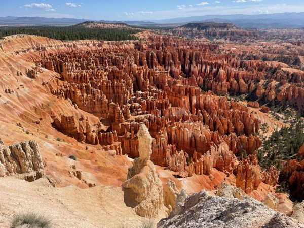
Ummm … yeah. The world is full of natural wonders, and the United States is home to quite a few of those places, and the Rocky Mountain West boasts its fair share of incredible views, but Utah is just stacked with scenic sites – it includes five national parks within its borders. The uncountable vertical rock formations in the foreground, boasting hues of red, yellow, and white, are called hoodoos. They’re formed, as are most really cool rock formations, by erosional processes. Bryce Canyon National Park contains the world’s greatest concentration of hoodoos.
Bryce Canyon National Park is the easternmost and highest “step” in the Grand Staircase, an immense geologic structure stretching across 100 miles of southern Utah and Arizona. The Grand Staircase includes two dozen distinct layers of rocks representing 525 million years of sedimentation from ancient inland seas, lakes, swamps, and forests. Arizona’s Grand Canyon contains the oldest rock layers and forms the western and lowest edge of the Grand Staircase.
Bryce Canyon National Park: By The Numbers
Date established as a national park
February 5, 1928 (declared a national monument on June 8, 1923)
Total area
35,835 acres (56 square miles, about one-seventh the size of Rocky Mountain National Park in Colorado)
Yearly visitors
2.4 million (RMNP receives 4.3 million)
Highest point
Rainbow Point, at 9,105 feet
Lowest point
Yellow Creek, at 6,620 feet
Despite its name, there aren’t any significant geologic canyons in the national park – the erosion of the limestone cliffs into the hoodoos and other formations we see today is mostly the work of frozen water rather than a flowing river. Between 55 and 35 million years ago, what is now Utah was a basin filled with mountains. Rivers in those mountains deposited tremendous amounts of dissolved limestone into huge lakes. About 20 million years ago, the Colorado Plateau was uplifted and the lakes were drained to expose the limestone layers that form the beautiful rock formations of Bryce Canyon. Erosional forces, including freezing and thawing water as well as rain and snow, over the ensuing years carved cliffs out of the limestone, which were eventually further sculpted into narrow walls called fins and then eventually rows of the rounded columnar formations called hoodoos; if you look at pictures of hoodoos and imagine the spaces filled with rock, that’s what the fins used to look like.
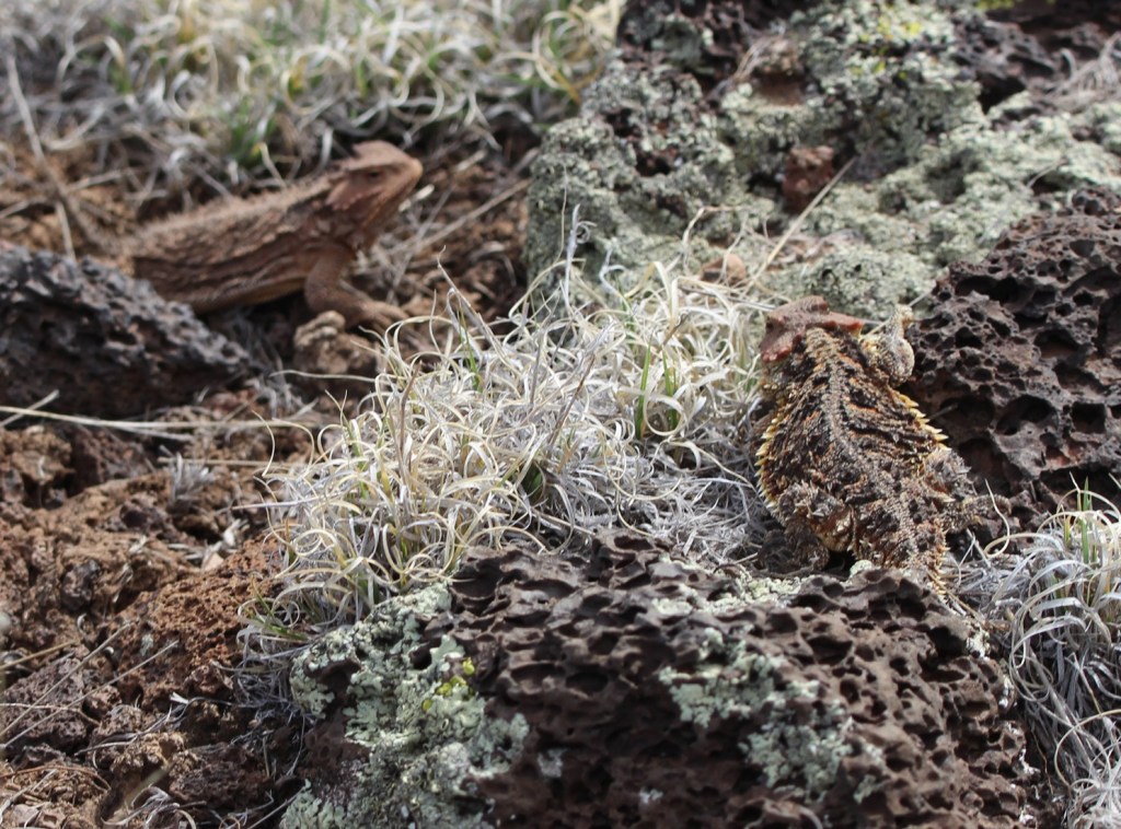
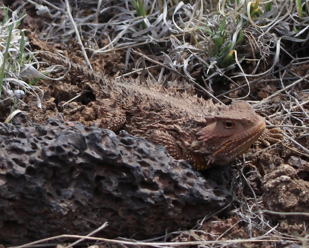
Although the skies weren’t crystal-clear the day we visited the national park, we still had some incredible views from the overlooks. This image was taken looking east. In addition to the marvelous rock walls and hoodoos in the foreground, formations 20 miles away and even further could be easily seen. Canaan Peak has an elevation of 9,293 feet. A winding hiking trail can be seen in the mid-foreground on the right side of this image.The national park’s namesake, Ebenezer Bryce, was born in Scotland in 1830. He was a ship’s carpenter and, after converting to the Church of Jesus Christ of Latter-day Saints, emigrated to the United States in 1848. He married Mary Park in Salt Lake City in 1854, and the family (which then included five children; he and Mary would have a total of 12) moved to southern Utah’s Pine Valley in 1862. Shortly thereafter, he moved to a homestead in the nearby Paria Valley which is south of the present-day national park. He built a road for timber access that ended in a natural bowl-shaped area, or amphitheater; that area became known as “Bryce’s Canyon.” In 1880, he and his family moved to Arizona, near Pima, where he passed away in 1913. [Photo courtesy Washington County (Utah) Historical Society.]The name of this pretty flower, the sego lily (Calochortus nuttallii), derives from a word (“sikoo”) in the language of the Shoshone, who taught early (and hungry) Mormons that nearly all of the plant, including the bulb, is edible. The plant’s value as an important pioneer foodstuff later led to the adoption of the sego lily as Utah’s state flower in 1911. The large-grained grass at left is Indian ricegrass (Eriocoma hymenoides), also an important part of native Americans’ diets. It is the state grass of both Utah and Nevada.The second column from left shows a “window,” in which the erosional power of frozen water, in the form of snow, frost, and ice, wedges small crevices into larger openings. It’s very likely that frost and rain will erode away the rock forming the top of the window, resulting in the columnar shapes called hoodoos. Because of its elevation, Bryce Canyon National Park experiences freezing temperatures half of the nights of the year.After enjoying the views from several overlooks while on a scenic drive around the park, we embarked on a fairly challenging hike in the early afternoon that combined the Navajo Loop with the Queen’s Garden Loop. It gave us the opportunity to walk on wooded footpaths, see plenty of wildflowers and birds, and marvel up-close at the rock formations. These hikers are walking past some hoodoos that have several windows.Here’s a view of the Queen’s Garden Loop namesake: if you squint at the top of the hoodoo just left of center, you can kind of maybe sort of make out something that resembles Victoria, Queen of the United Kingdom of Great Britain and Ireland (1819-1901). Did You Know/Care: there are almost 160 statues of Queen Victoria around the world. Also, I think it’s fun to imagine Queen Victoria saying the word “hoodoo.”THIS IS A TALES OF THE GODDARD LIZARD ALERT. Western fence lizards (Sceloporus occidentalis) have a wide distribution throughout the American West, and can live at elevations ranging from sea level all the way up to almost 11,000 feet. You can just begin to make out the most distinguishing characteristic of this species, its bright blue belly (look behind the right front leg).Nancy and I are both very experienced hikers and both of us recognize the need for switchbacks, or gradual increases in elevation by constructing a trail across the slope of an incline. These switchbacks at the end of the hike that day were the most in a relatively short distance that we’ve ever seen. It seemed like we walked 30 miles just to gain 300 feet of altitude. Still, it was an intensely rewarding hike and it was a great end to a great day at Bryce Canyon National Park.Looking northeast, this overlook at the end of the Queen’s Garden Loop awaits after that significant set of serious switchbacks. I mean, I’m writing this post one year after our visit to the park and I’m still just shaking my head at the views we experienced.THIS IS A BONUS TALES OF THE GODDARD LIZARD ALERT. This horned lizard was not at Bryce Canyon National Park, but in our campsite near Hatch, Utah, where we stayed for the week during our visit to the park. Horned lizards (I believe this is a greater short-horned lizard) are extremely well-camouflaged little creatures. Our campground was only 32 miles from Bryce Canyon National Park, but the winding drive took 45 minutes. We may have missed out on centennial-celebrating cake so we could make sure Gunther got outside for his afternoon walk, but, between the overlooks and hike we enjoyed, it was well worth it. Because of its remote location, Bryce Canyon is definitely a park that you have to want to get to, and that’s okay by us (but you should totally want to get to it).
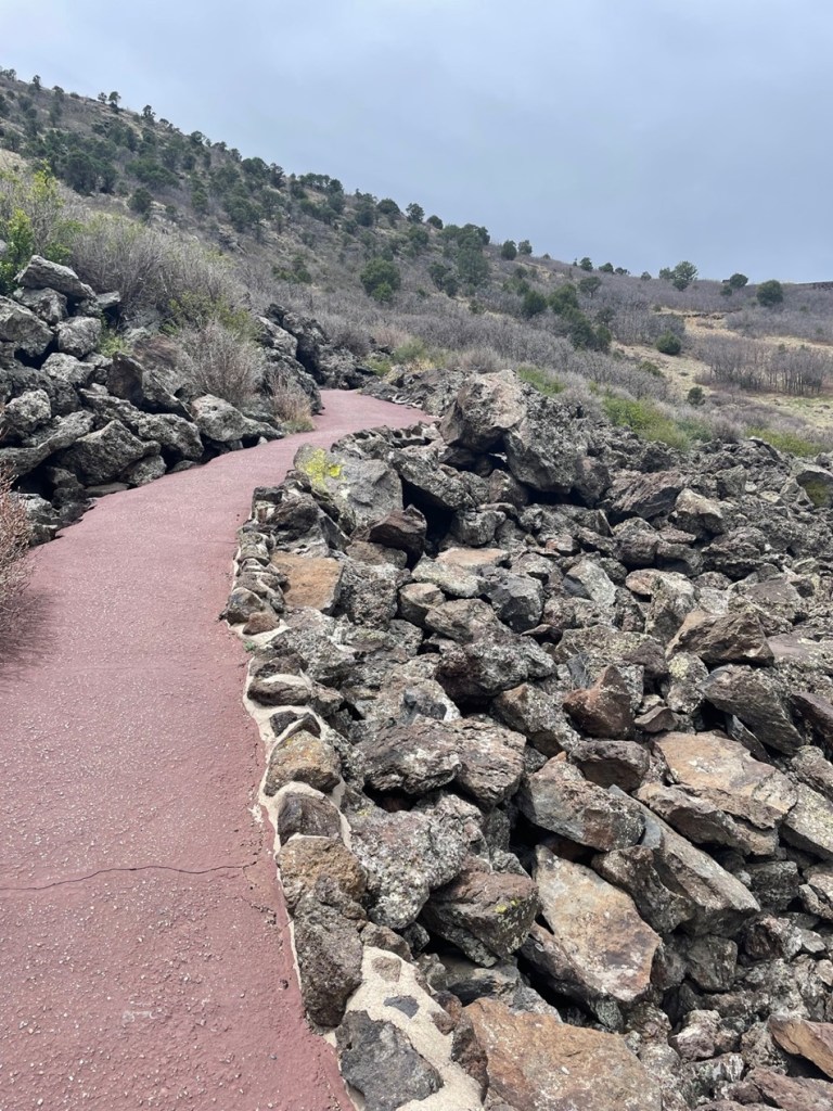
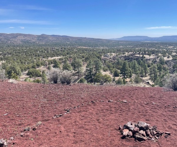
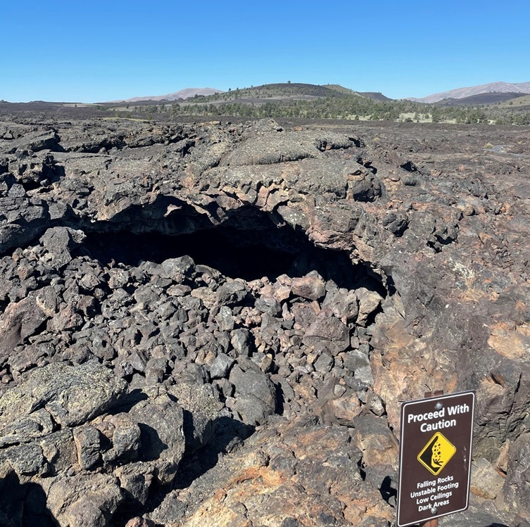
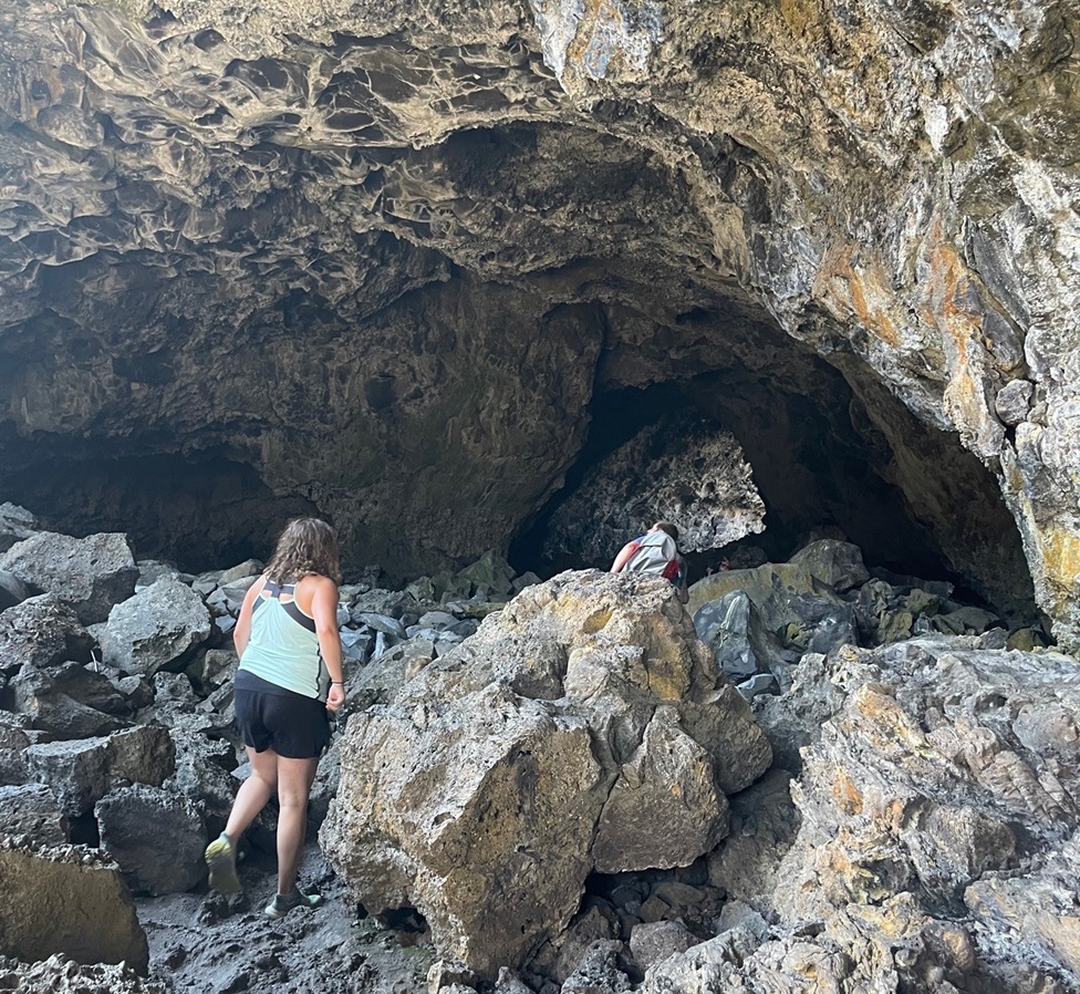
El Malpais (pr. el-mal-pie-EES) National Monument, located near the town of Grants in northwestern New Mexico, showcases a number of different geological features in its nearly 180 square miles – but it’s best known for its impressive lava flows dating from 60,000 to only 4,000 years ago.
While Native Americans have lived in the El Malpais area for 12,000 years, early 17th-century Spanish explorers coming north from Mexico found the region nearly impassable by their horse-drawn wagons and carts. Those explorers gave the region its name, which means “the bad land” in Spanish and refers to the rocky topography left behind by the extensive lava flows.
El Malpais National Monument was established on Dec. 31, 1987, and about 100,000 people visit it each year.
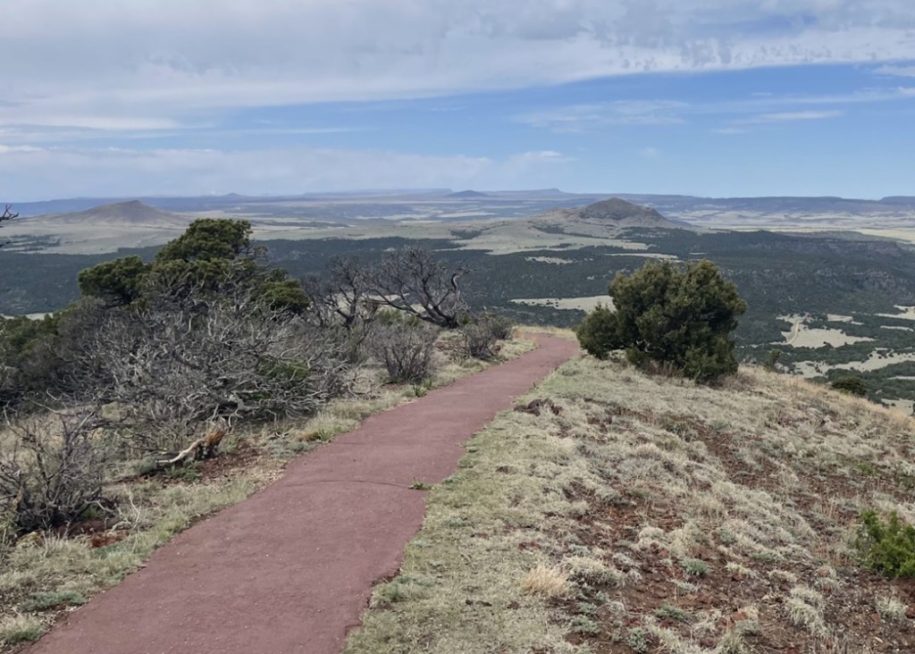
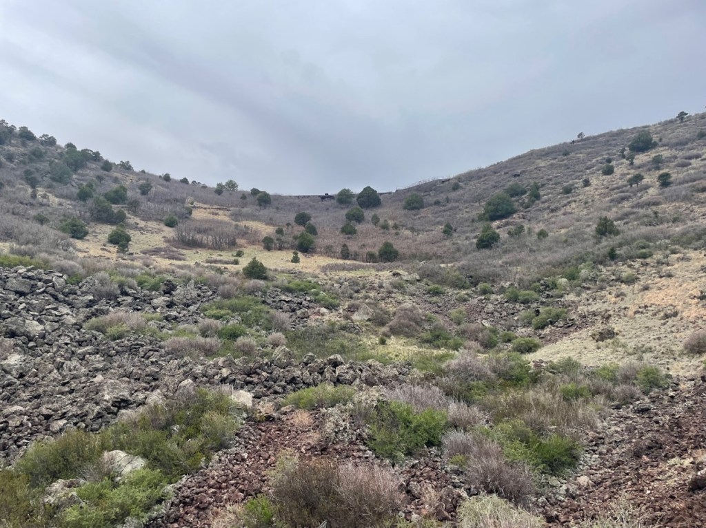
We camped for a week in Grants and visited several different features of the national monument. The highlight, however, was a great hike that took us to the top of a cinder cone from which much of the monument’s lava had flowed.
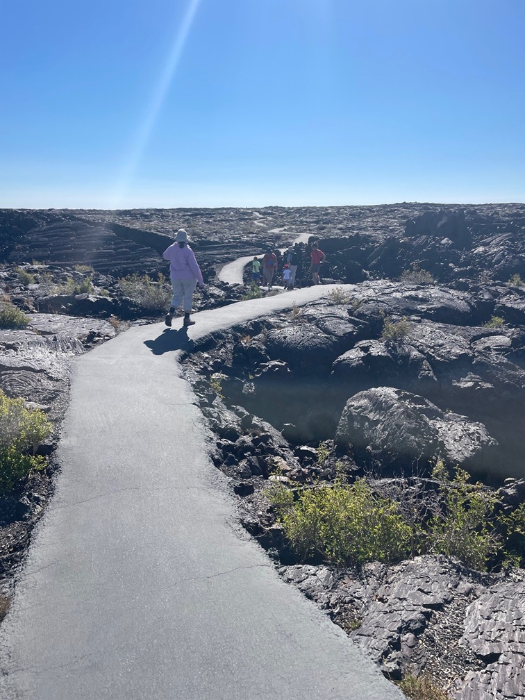
The El Calderon Trail is located on the western side of the national monument – it happened to be only a 20-mile drive from Grants. We’re still trying to adjust to being on trails that aren’t in Colorado: there were two other vehicles in the trailhead’s parking lot when we arrived at 10 AM, and in the entire course of the 5-mile loop hike, we saw nearly as many dogs (two) as we did people (three).
This iGoogle Maps satellite image, in which a quarter-inch represents two miles, shows nearly the entirety of El Malpais National Monument. The monument’s visitor center fs indicated at the top, and just to the left is the town of Grants, New Mexico, where we parked the Goddard for a week in April 2024. Grants is on Interstate 40 about halfway between the Arizona/New Mexico state line and the city of Albuquerque, New Mexico. Everything represented in dark greenish-black in the lower two-thirds of the image is basalt, or lava rock; the greenish hue is provided by plant life amongst the basalt. The town of Grants, too, is surrounded by basalt.
Shortly after the trailhead, the El Calderon trail passes by several caves that are actually lava tubes and are now home to bat populations. Lava tubes are formed when flowing lava exits an existing lava vent covered with a roof of lava rock, leaving behind a cave-like structure.
Here we see a brave hiker (it’s Nancy) at the entrance to Bat Cave in the national monument. This lava tube is a summer home for thousands of Mexican free-tailed bats that emerge at night to hunt for insects. There is still evidence of a guano mining operation in Bat Cave; bat droppings are high in nitrates and therefore valuable as fertilizer. We learned at Mammoth Cave National Park in Kentucky that guano was also once used in the production of gunpowder. To protect the flying mammal population, Bat Cave in El Malpais National Monument is closed to human visitors.Much of the El Calderon trail looks like this: relatively flat, with expansive views, through a moderately wooded forest with several different species of pine trees and evergreen shrubs.There weren’t many wildflowers in bloom when we hiked the El Calderon Trail on April 20, but we’d just missed the blossoms of the tree cholla (Cylindropuntia imbricata). Also known as cane cholla, this cactus typically grows to a height of 3 feet, but can reach 15 feet. The flowers are a very bright magenta color, and the yellow fruits, shaped roughly like a pinecone, can last on the plant for a long time. They apparently don’t taste great, but the Native Americans of present-day Arizona and New Mexico did use them as a food source.This is a TALES OF THE GODDARD LIZARD ALERT. I’d walked by this pair of horned lizards on the lava rocks lining the trail without seeing them but they didn’t escape the notice of Gunther, who Nancy had on a leash behind me. I was able to get several photos of them before we moved on down the trail. Their camouflage really is amazing – if they hadn’t moved as I passed by, Nancy said Gunther probably wouldn’t have seen them either.This is a close-up of the lizard in the background of the above photo. There are 21 species of horned lizards in the world, 15 of which are native to the United States. Five of them reside in El Malpais National Monument, and, without being familiar with any of them, I’ll just say this is one of those five species (although based on the coloration and locality I’m leaning toward a greater short-horned lizard, or Phrynosoma hernandesi). Horned lizards are often called horned toads, but they’re not toads or even amphibians at all: they are reptiles. It’s somehow reassuring to know that dinosaurs still walk among us, however small they may be. Females of the short-horned lizard species grow to about 7 centimeters (2.75 inches) SVL, while males grow to only 5 centimeters SVL. What’s SVL, you ask? I had to look it up as well: it’s an abbreviation for a herpetology term called snout-vent length (basically the length of the lizard not including the tail).The entire trail was lined with readily available lava rocks, which made for interesting viewing while hiking because of all of the different textures. Each was different, but the trailbuilders used rocks that were roughly a foot in height and width. One can only imagine the scene 115,000 years ago, when these rocks were being created: what did it look like, sound like, and smell like?We’ve seen plenty of lava tubes in Hawaii, Idaho, and now New Mexico, but I don’t think we’ve ever seen a distinct lava trench. They are formed in the same way as lava tubes, but the roof of the tube collapses soon after the lava of the tube cools. Water collects in the bottom of these trenches, allowing trees and other foliage to grow larger than their counterparts outside the trench.This is the side of the El Calderon cinder cone, from which rivers of magma flowed about 60,000 years ago to create immense rivers of lava that found their way 20 miles north to the present-day town of Grants. A cinder cone is formed when gravel-sized bits of lava are shot hundreds of feet into the air from a volcanic vent in the ground. The billions of tiny cinders fall back to earth and eventually form a cone-like structure; El Calderon is 300 feet high. The two different colors of cinders – red and black – indicate different mineral composition and different eruption periods. The trail includes an optional loop around the top of the cinder cone — it was a 300 foot gain in elevation, but the views were well worth the effort.This is a view looking northeast from the top of the El Calderon cinder cone (the side of the cinder cone pictured above is directly below this position). The red cinders contain high levels of oxidized iron: essentially, rust. On the far left of the photo one can just barely make out the snow-covered top of Mount Taylor (elev. 11,305 feet), about 30 miles away on the other side of the nearer hills. Mount Taylor is an extinct volcano that last erupted about 1.5 million years ago – long before the volcanic activity on El Malpais National Monument occurred. It is a mountain sacred to a number of Native American pueblos, including the Acoma, Zuni, Hopi, Laguna, and Navajo.This is a view looking down into the interior of El Calderon, fairly close to where the previous photo was taken but in the opposite direction. It’s a peaceful basin filled with pine trees and grasses now, but it was the source of all of those lava cinders shooting upwards into the sky when the volcano was active 60,000 years ago. El Calderon translates to “the cauldron” in Spanish.Time for lunch – trailside! We heard, but could not see, a couple of different birds singing in some nearby pines during our lunch. Afterwards, I got a couple of pictures of them. The pictures didn’t turn out well at all (they were still far away and the skies were overcast), but it turns out that they were gray flycatchers (Empidonax wrightii), and, judging by the grass in their beaks, they were building a nest.We saw these white growths on nearly every rubber rabbitbrush (Ericameria nauseosa) plant we saw on the hike. Nancy asked what they were and I replied that they were spider egg cases, each just waiting to pop with up to 100 individual spiderlings. She refused to believe me, which was probably the right thing to do, but it meant that I later had to look up what they really are. It turns out my wild guess wasn’t very far from the truth: they’re called galls, and they are home to larvae of a fruit fly. The galls, produced by the plant’s reaction to irritating chemicals introduced by the parasitic insect, act as both a home and a food source for the larvae. They don’t appear to harm the rabbitbrush plant at all.It’s a little difficult to make out in this picture, but there’s a tree species we weren’t expecting to see in northern New Mesico on the other side of the fallen log, just left of center. It’s an aspen tree, which is made possible by what the scientists call “the edge effect,” or additional moisture that collects along the area where lava fields meet conventional landscapes. The edge effect allows plants that need additional moisture, like aspens, to thrive in otherwise harsh environments.I thought the smooth side of this hunk of basalt was interesting: it indicates that the lava was moving fairly quickly as it cooled. Lava fields, after they cool and begin to erode, make for fairly good habitat for plants: the basaltic rocks hold a lot of water and trap a good variety of airborne seeds.The skies above us unfortunately still chose to be overcast when we saw this western bluebird (Sialia mexicana) perched on an oft-used branch, but the bird’s bright colors still impressed us. Western bluebirds are members of the thrush family, and their diet consists of worms and berries found on the ground as well as insects plucked from the air.The trail on the right side of this photo is the 2,700-mile-long Continental Divide Trail, which meets and shares some distance with the El Calderon Trail. If one were to follow that path, one would wind up at the Canadian border with Montana. We elected to continue on our loop to the El Calderon trailhead instead.
The hike to El Calderon was one of the more rewarding trails Nancy and I have been on in a long time: fantastic views, lots of fascinating geologic features, a good variety of plants, and a bit of wildlife to observe.
There is a lot of geology to appreciate about El Malpais National Monument, and not all of it has to do with lava. On a weekday evening, Gunther and Nancy and I drove to the east side of the monument to see two sandstone features: La Ventana and a sandstone bluffs overlook.
About 160 million years ago, the El Malpais area looked a lot like today’s Sahara Desert: covered with hundreds of feet of sand that, compressed by other layers of sediment, eventually formed sandstone. This arch, formed by the weathering effects of freezing and thawing water trapped in the sediment over millions of years, is 135 feet across and only 25 feet wide at its thinnest point. Spanish explorers called this arch “La Ventana,” or “the window.” It is one of the largest natural stone arches in the state of New Mexico.This is a sandstone bluff overlook that provides great views of the basaltic lava flows hundreds of feet below. More than 200 volcanic vents have been identified in the national monument, and this sandstone is tens of millions of years older than any of them.
Nancy and I both have more than a passing interest in geology, and especially volcanoes, so El Malpais National Monument was a great place to spend a week. We spent the summer of 2023 surrounded by volcanic features in Idaho, and it was fun to once again be amongst these reminders in New Mexico that our planet continues to reshape itself all the time.
Craters of the Moon National Monument, located midway between Twin Falls and Idaho Falls in the south-central part of Idaho, is one of those National Park Service sites that you kind of have to want to get to. The monument and its associated preserve receive only about 220,000 visitors each year; for comparison’s sake, Rocky Mountain National Park northwest of Denver receives more than 4 million visitors annually. Craters of the Moon is not on any Interstate highways, and it’s about 90 miles from Twin Falls and more than a two-hour drive from Idaho Falls. I imagine many of its visitors are on their way to or from Yellowstone National Park, which gets about 3.3 million visitors each year.
Thousands of years ago, these rocks were part of a slow-moving river of magma. Craters of the Moon National Monument doesn’t have especially tall volcanoes – it has about 20 cinder cones that top out at about 700 feet in height – but it does have immense flows of basalt resulting from lava that escaped through fissures in the earth. As they cooled, the magma flows hardened into these beautiful rock structures.
Still, it’s a unique and beautiful place that clearly shows that the area was the site of tremendous volcanic activity in the planet’s relatively recent past. We parked the Goddard in Arco, Idaho, about an hour’s drive northeast of Craters of the Moon and visited the monument not once but twice in a week. Why? Lava! And cave-like geologic structures!
The year 2024 marks the hundredth year since the establishment of the monument. The monument and preserve protects 753,000 acres (about 1,200 square miles) of south-central Idaho for visitors to experience what it could be like to walk on another world. The scientists have dated some of the lava flows and have determined that the area experienced an extended period of geologic activity – and one that was quite recent, geologically speaking. The oldest lava flows yet recorded are from eruptions 15,000 years ago, and the most recent flows occurred just 2,100 years ago.
Our first impression of the national monument: everything is black, due to the miles and miles of basalt that’s all around. It’s really difficult for plant life to establish itself in relatively new basaltic soil; total vegetation coverage on the entire monument is less than 15 percent, and on cinder cones like this it’s only 5 percent. Here we see an intrepid hiker (it’s Nancy) making her way up the slope of Inferno Cone, a tall cinder cone in the monument. Cinder cones are the most common type of volcanic structure on Earth. The lava emissions at what is now Craters of the Moon were less explosive than many other eruptions around the world, so the slopes of the cinder cones are gentler. It’s a little less than a half-mile to the top of the cone, from which one can see 360 degrees all around Idaho (and on especially clear days even the peaks of the Teton Range, 100 miles away in western Wyoming, can be spotted). The sun, pictured in the upper right of this image, is no joke: its rays can heat the black basalt to temperatures of 150 degrees. Winters can be harsh as well, with plenty of snow and frigid temperatures.
Craters of the Moon contains the largest lava field in what is known as the Great Rift, a 53-mile-long fissure in Idaho running from the southeast to the northwest. The relatively quiet (as quiet as a volcanic eruption can be, anyway) release of gas and magma created these lava flows over a period of many thousands of years. This part of Idaho has several other such lava fields and the soil that has resulted from those older flows results in regions famed for growing fine potatoes. (There were a couple of grocery stores in Idaho in which the smallest baking potatoes weighed a pound.)
In time, the soil in the national monument may break down enough (through the work of erosional forces like wind, water, and plant growth) to allow more plants to survive. Until then, it’s pretty desolate but in a beautiful way, and any potato harvests in this particular part of Idaho will be many years in the future. Incidentally, it’s believed that the caldera underneath Yellowstone National Park, which is responsible for the geysers, paint pots, and other hydrothermal features there (and possibly a mass extinction event if it erupts while humankind is still around), is connected to the hotspot that created Idaho’s lava fields. Over millions of years, the North American Plate has been moving slowly while the hotspot heats up the landform currently over it: 10 or 11 million years ago, that hotspot was underneath what is now Craters of the Moon National Monument.
In order to survive, plants and animals have to be extraordinarily adapted to make it in both extreme heat and cold. This is dwarf buckwheat (Eriogonum ovalifolium), a plant only four inches tall that can boast a root system up to three feet in diameter. That root system works to get as much moisture to the rest of the plant as it can, and this plant is so efficient at doing so that plants can’t survive within about three feet of each other – they wind up being so evenly spaced that they appear to have been hand-planted. Additionally, the plants light-colored leaves reflect, rather than absorb, the sun’s rays. Note the texture of the black basaltic soil.
Craters of the Moon was established and named as a national monument almost 50 years before NASA put astronauts on Earth’s actual moon, so it wasn’t until the very late 1960s and early 1970s that it was discovered that the moon’s surface isn’t anything like southern Idaho. The moon has been shaped by impacts of meteorites rather than volcanic eruptions. But the national monument did serve as an ideal training ground for astronauts so they could practice selecting rock samples in an unfamiliar environment.
While we hiked up Inferno Cone, we saw a few turkey vultures (Cathartes aura) circling in the beautiful blue sky and perching in this dead limber pine tree. I took several pictures of this bunch, but they apparently had more important things to look at than me and they never turned around. These birds can have wingspans of up to six feet in length. Turkey vultures aren’t the most attractive representatives of the avian world, but their diet of nearly exclusively carrion is essential to preserving the natural order of things.This is known as a spatter cone, formed when jets of lava spout vertically from the earth – for scale, that’s a person on the trail in the shadow of the cone. The monument and preserve contains about 25 cones of the spatter and cinder (such as Inferno Cinder) varieties.We happily joined a ranger-led hike to some lava tubes. We’d seen lava tubes in Hawaii many years ago, and were more than a little surprised to see them again in Idaho. This was a pretty nifty asphalt trail that wound through the basalt formations and led to the tube structures.Here is the opening to a lava tube that we didn’t enter, and you can probably see why we didn’t. The jumble of large rocks near the opening are the result of the overlying rock atop the tube collapsing into the void and down to the ground. This lava traveled 18 miles from its source, the spatter cones pictured above.Here’s the lava tube that we did enter. It was a really impressive cave-like structure, formed when a river of lava continues to flow underneath a layer of magma that has already hardened on top of it. When the supply of lava is cut off, the opening through which the lava flowed remains to form these interesting structures. The empty spaces are home to bats, just like a cave. We didn’t see any bats, but I did capture a photo of a rock pigeon in the lava tube. You know what a rock pigeon looks like, so I won’t post it. It was kind of neat to see a species of bird that’s common on big-city streets in a lava tube in very rural Idaho, though.While the first day we visited the national monument was clear with blue skies, the second day was mostly overcast and chilly. On a short hike around the lava flows, we saw several of these birds performing some impressive aerobatic maneuvers, presumably catching insects in flight. We couldn’t tell what kind of birds they were until this one landed in a tree. It’s a nighthawk, of which there are several species in North America. I don’t know which particular one this is (I’m guessing it’s a common nighthawk), but we were pretty excited to see it – we’d never seen a nighthawk before. They’re a mostly nocturnal species, so maybe the cloud cover was enough to make them active during the day.One of the hiking trails we enjoyed led to this impression of trees that were growing thousands of years ago and then were downed in the flowing magma, leaving behind these distinct patterns of bark growth in the basalt.I didn’t take this photo at the national monument, but rather at the campground in Arco where the Goddard was parked. I’m including it because it was another new-to-us bird, a plain-looking little fellow with the splendid name of western wood-pewee (Contopus sordidulus). They are about six inches long, weigh just a half-ounce, and have a wingspan of about 10 inches. Like other birds in the flycatcher family, this species is particularly skilled at snagging insects in flight.
Craters of the Moon National Monument has a lot going for it, and we were fortunate to be able to include it in our summer 2023 itinerary. We saw plenty of other places with lava flows both (relatively) new and old in Idaho – we spent more than two months in the southern and southeastern part of the state – but it was fun to be able to walk across the basalt and wonder what the environment must have looked like when the lava was flowing. Interestingly, the volcanic features at Craters of the Moon are believed to be only dormant – not extinct – and geologists expect the region to become active once again within the next thousand years, and some believe it could be within the coming century.
Grand Staircase-Escalante National Monument is big – really big. In fact, although it’s the seventh-largest U.S. national monument by size, it’s the biggest in the country that’s not either entirely in or adjacent to an ocean. At 1.87 million acres (just over 2,900 square miles), the national monument is nearly twice as big as the entire state of Rhode Island, and just a tad bigger than the state of Delaware.
This area in southern Utah is vast, and it is remote: it was the last part of the contiguous United States to be mapped by the federal government. Grand Staircase-Escalante National Monument was authorized by President Bill Clinton in 1996. This is also one of the more contentious federal properties; President Donald Trump effectively halved its acreage in 2017, and then President Joe Biden restored it to its current size in 2021. It is the first national monument to be administered solely by the Bureau of Land Management (BLM).
(A brief sidenote: the U.S. government’s holding of lands, especially at the levels of national monuments and especially those in the western United States, is criticized by some groups and lauded by others. Much of these lands frankly isn’t good for anything except looking beautiful and supporting native plants and animals – which, in the eyes of some, is more than enough reason to provide federal protection. Other groups are interested not so much in the lands themselves, but what’s under the lands’ surfaces: minerals, petroleum, and other extractive materials. Everyone from kayakers to native Americans to miners to anglers to ranchers to tourists wanting a scenic drive has an opinion on what should and shouldn’t happen on these lands. U.S. presidents are able to establish and change landholdings under national monument status as they see fit; acts of Congress are needed to establish or change national parks. I’m someone who enjoys nature quite a lot, but I also realize that I use minerals and petroleum extracted from the earth nearly every minute of every day – in the laptop I’m typing on, in the fifth-wheel trailer in which we live, and in the iPhone and digital camera with which the following photos were taken. You most likely are equally dependent on those extractive resources. As with most issues in life, it takes a balance. Grand Staircase-Escalante National Monument is especially contentious because county and state governments also want to maintain at least some control over what can and can’t happen within its borders.)
(That sidenote was less brief than I’d expected.)
Anywho, Grand Staircase-Escalante National Monument takes up a sizable chunk of southeastern Utah. It protects three major areas: the Grand Staircase, the Kaiparowits Plateau, and the Canyons of the Escalante. The Grand Staircase is so named because of its stepped appearance if viewed from the side: from west to east, the landscape drops in elevation in enormous eroded and even layers. The steps drop, west to east, in cliffs measured in hundreds of feet. The area represents 400 million years of geologic development.
The views at Grand Staircase-Escalante National Monument are simply spectacular. The monument is bordered by Bryce Canyon National Park on its western edge and by Glen Canyon National Recreation Atea on its eastern side.
One fun thing to do in these federally protected lands is to go on a hike, and that’s what Nancy and I did in late May of 2023. The Toadstool Trail leads to some wonderful rock formations and other features of this otherworldly environment. In its easy out-and-back 1.5 miles, one can see rocks eroded from water, rain, and other elements to create some pretty stunning scenery. We happened to visit the area when a number of flowering desert plants were in bloom, which was great to see.
We visited the national monument on a beautiful day in late spring, when there was little chance of rain, but there was plenty of evidence that the area receives considerable amounts of moisture at times. This ravine was cut by a seasonal watercourse; the hiking trail is at the far right of the photo. Note the coloration of the different layers of rocks in the cliffside.This pretty flower is a sego lily (Calochortus nuttallii), which happens to be the state flower of Utah. We saw quite a few of these blossoms, which can measure up to three inches across, on the hike. “Sego” is believed to derive from the Shoshone name of the plant.There’s a lot going on in that cliff, not the least of which is the wavy nature of the rock layers on the left. I took this photo from a U-bend in the trail (it continues on the left and right of the photo) and you can see some hikers near the center of the photo.This is a TALES OF THE GODDARD LIZARD ALERT. I’m not an expert on reptile identification (I’m not really an expert on anything, come to think of it), but I believe this to be a common side-blotched lizard (Uta stansburiana). They grow to a length of about 2.5 inches not including the tail, which is often longer than the body. Judging from the Wikipedia page on these little rascals, a lot of the scientists have spent a lot of time observing this species. This is a lizard that can safely lose its tail to escape a predator, but that comes at a terrible cost: loss of social status within a group of other common side-blotched lizards. We saw several of these lizards and all still had their tails, so we were among the elite. This isn’t the first lizard species to live in the area; researchers have found fossils of several different dinosaurs within the borders of the monument.This is the largest rock formation from which the Toadstools Trail gets its name, and it’s plenty spectacular. If I had to guess, I’d say the column is about 25 feet tall. Formations like this occur when softer rock under harder, denser rock is eroded away. These are basically small buttes, with more material underneath the surface caprock taken away by water, wind, and other erosional forces, to form a toadstool formation.I thought this rock wall was interesting because it shows not just the colors of the different rock layers, but the different density of the layers as well: note the edge-on layers of rocks upon which less-dense layers, which are disintegrating faster, were deposited over millions of years.The bright blossoms of this plains pricklypear (Opuntia polyacantha) were hard to miss in an otherwise tan-colored environment. The flowers of this species of cactus can be yellow, red, or magenta, as on this specimen. These plants provide a source of food for quite a few animals, like prairie dogs and pronghorns, and many people enjoy eating the fruit (if animals haven’t gotten to them first) once the blossoms are spent.Although the larger toadstools are very impressive, the rock formation – a column supporting a wider, flat cap of harder stone – is fairly common in the area. They make for some interesting viewing opportunities.This is Coulter’s lupine (Lupinus sparsiflorus), also known as Mohave lupine or desert lupine. The plants grow to a maximum height of about 16 inches. We’ve seen this pretty flower elsewhere in the deserts of the western United States; it, along with the other plants that happen to be flowering at the time, provides a nice pop of color.This blurry photo is unfortunately the best of three I took before this rock wren (Salpinctes obsoletus) took off to raise havoc somewhere else. This species, fairly common in the western part of the country, is adapted to cling to rock faces while hunting for insects and spiders.Shortly after we’d started this hike, another hiker suggested that we continue walking past the main toadstool formations for some really nice views, more toadstools, and balanced rocks. We took his advice, and we’re glad we did. I’m going to guess that it’s six or eight miles to the horizon. Here we see a lone hiker (it’s Nancy) looking west; Kanab, Utah, is about 40 miles thataway.In this very arid environment, anything that moves and (especially) is not some shade of brown quickly catches your eye. This caterpillar is the larval stage of a really nifty moth called the white-lined sphinx, or hummingbird moth (Hyles lineata). The adult version of this species can be easily mistaken for a hummingbird as it hovers over blossoming flowers. The species is very common from central America up into Canada, including most of the United States. The spike at the back end of the caterpillar isn’t a stinger but it does give this larval form another name: hornworm. They aren’t harmful to humans but given a big enough population, these voracious eaters can destroy cultivated crops and flowers. Conversely, the adult moth form is beneficial for plants because of its ability to pollinate while feeding.That hiker who suggested that we continue our walk past the main formations was absolutely right, and we were able to see some really pretty toadstools and long vistasThe yellow blossom on the left is red dome blanketflower (Gaillardia pinnatifida), while the white blossom belongs to a flowering plant called birdcage evening primrose (Oenothera deltoides). Because they don’t require a lot of care, blanketflower species are very popular in home flower gardens – I planted some of them in our xeriscaped lawn in Denver.The cliffs, toadstools, balanced rocks, and other rock formations in the national monument were created by erosion and plenty of time. I’m including this photo to show how even tiny trickles of water coming down a rock face can create really interesting designs.Native American cultures arrived in what is now the national monument around 1,500 years ago. There are hundreds of petroglyphs that document those peoples’ existence in the area, and the rock in the foreground looks to have two of them. This was at the mouth of a very short canyon eroded into a cliff wall.Here’s a closeup of one of the petroglyphs on the rock pictured above. I have no reason to think it’s not genuine, but I sure can’t think of any horned quadrupeds that also have long tails. Maybe it’s a depiction of something else entirely.On the way back to the trailbead, another hiker with a digital camera and long lens was as excited as me to see this bird about 50 yards away from us. We couldn’t identify the species at that distance, so I was certainly looking forward to getting back to the Goddard and looking at the picture on a larger screen. “What kind of exotic birds could possibly live in this remarkable desert environment?” thought I, taking picture after picture of a bird I couldn’t make out through the camera lens. Turns out, it’s a house finch (Haemorhous mexicanus) which is common all over the country so it’s not nearly as exciting as I first thought. However, I’ve gone some days without seeing any birds at all and those days aren’t any fun so I’ve learned to appreciate all the birds I see, no matter how common they are.This photo was not taken on the Toadstools Trail, but I wanted to include it in this posting about Grand Staircase-Escalante National Monument. It shows a spectacular bluff above a former townsite called Paria, which was a Mormon settlement from 1870 to 1929. The town was abandoned because it kept getting inundated by floodwaters. It must have been a tremendously hard way of life, separated from other communities by dozens of miles, but at least the view was pretty good.
About 190 million years ago, much of the present-day southwestern United States was covered in an immense field of sand dunes – one of the largest that has ever existed on the planet. Many of the dunes happened to carry iron pigment, which turned red when it was oxidized by the sun.
Over the course of millions of years, and with the help of chemical compounds like calcium carbonate and iron oxide, the dunes were slowly cemented into a rock called Aztec sandstone.
These sandstone formations are the primary feature of Red Rock Canyon National Conservation Area, located only about 15 miles west of the casinos, hotels, nightclubs and other delightful debauchery of Las Vegas, Nevada. The area includes nearly 200,000 acres (about 300 square miles) of the Mohave Desert, and it’s visited by 3 million people each year – a little less than what Yellowstone National Park in Wyoming receives.
It’s an impressive number of visitors, to be sure. I think, however, that most of Red Rock Canyon’s visitors are from the Las Vegas area. Its canyons and sandstone cliffs make it remarkably unlike most of the rest of the flat desert surrounding the city, and it’s extremely popular with hikers, cyclists, and rock climbers. Consider that Las Vegas’s Harry Reid International Airport (until 2021 McCarran International Airport) saw almost 58 million passengers arrive and depart in 2023, and it’s easy to see that most of those people aren’t coming to The Entertainment Capital of the World to entertain themselves by visiting a national conservation area.
Being avid hikers with interests in geology and biology, Nancy and I (and Gunther) went to Red Rock Canyon National Conservation Area in early December 2023. We were happy to be joined by a Canadian couple we met at the campground in Las Vegas at which we were staying; it turns out that Canadians enjoy hiking as well. They also joined us for a visit to the Hoover Dam, a hike in Lake Mead National Recreation Area, and a hike in Valley of Fire State Park north of Las Vegas (not all on the same day).
A one-way scenic drive, a loop 13 miles in length, at Red Rock Canyon provides many pullouts and parking lots with access to hiking trailheads (beginning a total of 22 trails ranging in length from under one mile to more than 10 miles), overlooks, and other points of interest.
It’s easy to see how Red Rock Canyon got its name. The sand originally forming the dunes contained an abundance of minerals, one of which was iron that was oxidized by the elements over millions of years. The area began its federal protection in 1967, when the Bureau of Land Management (BLM) designated 10,000 acres as the Red Rock Recreation Lands. Further legislation over the years and significant additions of acreage eventually led to the National Conservation Area designation in 1990.I was struck by the clear delineation of colors in the rock. These two different colors of rock are both types of sandstone, but water moving through the sand at the bottom millions of years ago took away the red minerals and left behind calcium carbonate. The sand later developed, over even more millions of years, into sandstone.Erosional forces like water and wind result in some really cool-looking rock formations. Note, also, that the light-colored and red layers of rocks are the reverse of the photo above (and I didn’t post it upside-down).These huge sandstone blocks are not naturally formed: they’re remnants of one of the earliest industries in the Las Vegas area. The Excelsior Stone Quarry began operations in 1905, extracting blocks of sandstone for use as building materials. The blocks, some weighing up to 10 tons, were pulled with a 17-ton steam-traction engine to the just-built railroad in Las Vegas and loaded onto railroad cars bound for Los Angeles and San Francisco, where they served as decorative building material. While the sandstone was judged to be of exceptionally fine quality, quarries closer to California’s coastal cities were later developed and the Excelsior Stone Quarry and other operations in the area shut down for good in 1912. The plant growing in front of the large block is a species of yerba santa, which is Spanish for “sacred herb.” The name comes from the plant’s medicinal properties to treat respiratory and digestive ailments – even today, yerba santa extracts can be found in western U.S. herbal medicine stores.Part of the day included a hike on the Calico Tanks Trail. The long views and beautiful multicolored rock formations along the trail reminded Nancy and me of several places in Colorado, including Garden of the Gods in Colorado Springs and the Red Rocks Amphitheater near Morrison. Two hikers can be seen in the lower-left corner of this image. The BLM has classified the Calico Tanks Trail as “moderate”; I’d say, based on the elevation gain and necessity to scramble up and over rocks, it’s on the far end of “moderate.” It was a beautiful hike, though.These curves in the sandstone were created while the materials were still in the form of loose sand. Wind blowing across the dunes created these lifted layers before the grains of sand were cemented into the sandstone of today.This specimen of Spanish dagger (Yucca schidigera, also known as Mohave yucca) reminded us that we were in the desert. It, like many plants found in the Mohave and other deserts, looks pretty savage.Speaking of savage, Gunther takes a break on the Calico Tanks Trail to enjoy the scenery. He got along really well with the Canadians; he gets along really well with pretty much everyone, no matter their country of origin.This is the feature for which Calico Tanks Trail gets its name: a seasonal pond, or tank, created by water seeping or flowing into a depression in the sandstone (there was a much smaller water feature earlier in the trail, thus the plurality of the trail’s name). The Spanish word for this formation is “tinaja,” which means “clay pot.” The sun on this early December day was pretty low in the sky, making for some considerable shadows from the rock formations. Those of you who have been to Las Vegas will probably think this tank is the third-largest standing body of water in the area after Lake Mead and the fountains in front of the Bellagio resort on the Las Vegas Strip; I would not disagree with that assessment. Formations like this make possible a huge diversity of plant and animal life that otherwise couldn’t survive in the desert.If you squint, the hotels and casinos of Las Vegas can just barely be made out near the horizon in this image, taken at the end of the Calico Tanks Trail. This vantage point took some rock scrambling to get to; along with my phone, with which I took this and most of the rest of the photos in this posting, I was also carrying my digital camera with a large and heavy zoom lens in case we saw any wildlife. A fellow hiker noticed the camera and said I was brave for bringing it along; I corrected him and said I was dumb.So that I didn’t bring my heavy camera lens on the Calico Tanks Trail for naught, here’s a picture of a rock climber I took with it. Rock climbing is a pastime in which I have absolutely no interest in participating.Yeah, this looks like just heaps of fun. The BLM’s website states that rock climbing at the national conservation area is among the best in the world. Red Rock Canyon National Conservation Area is one of more than 850 areas managed by the BLM’s National Landscape Conservation System, which totals 27 million acres of areas designated as National Conservation Areas, National Monuments, Wilderness Areas, Wilderness Study Areas, Wild and Scenic Rivers, and National Historic and Scenic Trails.Longtime readers of this blog know that I won’t pass up an opportunity to post an image of lichen. I have no idea what species this is, but I think the shade of green is best described as “obscene.” Together with wind and moisture, plants and lichens do their part to erode the rocks into all kinds of fantastic formations.This is a view from High Point Overlook (elev. 4,771 feet) looking east toward the city of Las Vegas, which is 15 miles on the other side of the rock formation. High Point Overlook is just a little shy of the midway point of Red Rock Canyon’s scenic drive. The vegetation in the foreground gives an idea of what the flat parts of the area are like; it appears kind of sparse, but it’s much more heavily vegetated than other areas we’ve seen around Las Vegas. There are about 600 species of plants found in the conservation area, a number boosted considerably by the presence of year-round water: the sandstone allows water to percolate, creating springs, pools of standing water like the Calico Tanks, and even small creeks and waterfalls .This is Turtlehead Peak (elev. 6.323 feet), also photographed from High Point Overlook. There’s a trail to the top, but it’s 5 miles round-trip with a 2,000-foot elevation gain, and Gunther didn’t want to try it so we didn’t. That’s a heavily laden Utah juniper (Juniperus osteosperma) on the left, with Mormon tea (Ephedra nevadensis) growing at its base.I wasn’t planning to see any natural bodies of water in Red Rock Canyon National Conservation Area, let alone one that was flowing. This is Lost Creek, along which we saw a huge diversity of plant life flourishing in early December. I will remember this very short hike off the scenic loop for a couple of reasons: this stream, and the fact that Nancy bonked her head on a low-hanging ponderosa pine branch that was overhanging the trail; she didn’t see it because of her hat brim. If she hadn’t been in the lead of our hiking party, any of the other three of us would probably have bonked our heads (even though he was ahead of Nancy, Gunther didn’t bonk his head because he’s an expert hiker. And he was able to just walk under the branch, without making note of the obstruction to Nancy.) We’ve discovered that the maintenance of trails in the federal system can vary greatly; BLM trails are perhaps the most … rustic. It’s really not a problem, and I’m certainly not complaining. It’s just interesting to see.Here’s an example of the diversity of plant life in Red Rock Canyon National Conservation Area: a specimen of ashy silktassel (Garrya flavescens), growing along Lost Creek. I’ve never knowingly seen it before. It can grow up to about 10 feet high. Another short trail from the scenic loop leads to a grouping of petroglyphs and pictographs, created by native Americans thousands of years ago. The minerals in rock exposed to the intense desert sun over the millennia develop a dark patina called desert varnish. The native Americans removed the patina with stone tools to expose the lighter colors of the original rock beneath, creating designs known as petroglyphs. Pictographs, in contrast, are designs created with paints made with clays, charcoal, and other minerals, and then applied to the rocks.Here’s a closer view of the petroglyphs in the photo above this one. The meanings or significance of these designs have been lost to time; the only communicative records of the people who created these designs that still exist are the petroglyphs themselves. Nancy and I have seen quite a few petroglyphs in New Mexico and Arizona, but it was a bit surreal to see these ancient designs just 15 miles from the (barely) controlled 24-hour party of the Las Vegas Strip.Here’s an example of a pictograph, or an image painted on the rock, located just a few yards away from the petroglyphs. It’s a little hard to see in this photo, but petroglyphs and pictographs are themselves sometimes hard to see in the wild. There’s a closer view of the pictograph below.The pictograph looks like a figure 8 with a vertical line inscribed through it (it’s just to the right of dead center in the photograph above). Again, we have no idea what its significance is, but it must have been important to someone a very long time ago. The BLM and other federal agencies take great care to protect these cultural artifacts; like in other areas around the country, the precise locations of many of the pictographs and petroglyphs in Red Rock Canyon are not made available to the public. Six major groups of native Americans have lived in what is now Red Rock Canyon, beginning with the Tule Springs Paleo-Indian culture 11,000 to 8,000 years ago.
A visit to Red Rock Canyon National Conservation Area had been highly recommended by one of our Lyft drivers who happened to be a native of Las Vegas, and she was right to do so. I mean, we would have gone regardless, but our visit definitely blew past what I thought it would be like. I sure wasn’t expecting to see those incredible views, enjoy fascinatingly colorful rock formations, and go on a hike next to a running stream, let alone appreciate imagery left by native Americans thousands upon thousands of years ago, but Red Rock Canyon had all of that and more. If you do find yourself in the Entertainment Capital of the World and want to experience something completely unlike what Las Vegas is known for, Red Rock Canyon National Conservation Area is a wonderful place to spend a day.