About 190 million years ago, much of the present-day southwestern United States was covered in an immense field of sand dunes – one of the largest that has ever existed on the planet. Many of the dunes happened to carry iron pigment, which turned red when it was oxidized by the sun.
Over the course of millions of years, and with the help of chemical compounds like calcium carbonate and iron oxide, the dunes were slowly cemented into a rock called Aztec sandstone.
These sandstone formations are the primary feature of Red Rock Canyon National Conservation Area, located only about 15 miles west of the casinos, hotels, nightclubs and other delightful debauchery of Las Vegas, Nevada. The area includes nearly 200,000 acres (about 300 square miles) of the Mohave Desert, and it’s visited by 3 million people each year – a little less than what Yellowstone National Park in Wyoming receives.
It’s an impressive number of visitors, to be sure. I think, however, that most of Red Rock Canyon’s visitors are from the Las Vegas area. Its canyons and sandstone cliffs make it remarkably unlike most of the rest of the flat desert surrounding the city, and it’s extremely popular with hikers, cyclists, and rock climbers. Consider that Las Vegas’s Harry Reid International Airport (until 2021 McCarran International Airport) saw almost 58 million passengers arrive and depart in 2023, and it’s easy to see that most of those people aren’t coming to The Entertainment Capital of the World to entertain themselves by visiting a national conservation area.
Being avid hikers with interests in geology and biology, Nancy and I (and Gunther) went to Red Rock Canyon National Conservation Area in early December 2023. We were happy to be joined by a Canadian couple we met at the campground in Las Vegas at which we were staying; it turns out that Canadians enjoy hiking as well. They also joined us for a visit to the Hoover Dam, a hike in Lake Mead National Recreation Area, and a hike in Valley of Fire State Park north of Las Vegas (not all on the same day).
A one-way scenic drive, a loop 13 miles in length, at Red Rock Canyon provides many pullouts and parking lots with access to hiking trailheads (beginning a total of 22 trails ranging in length from under one mile to more than 10 miles), overlooks, and other points of interest.
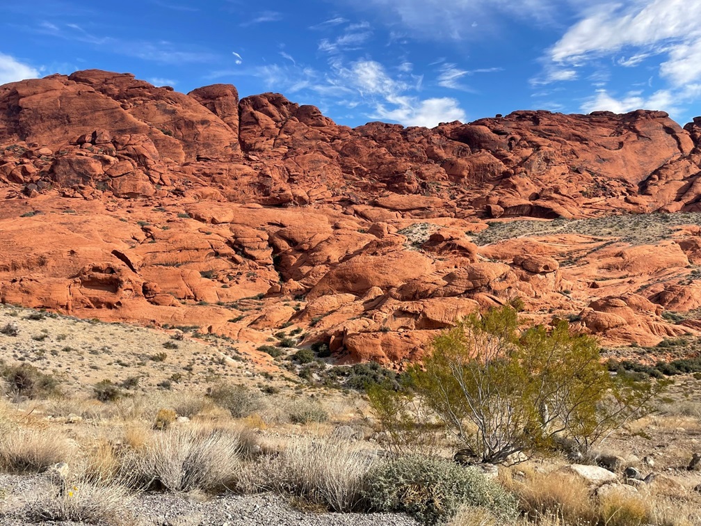
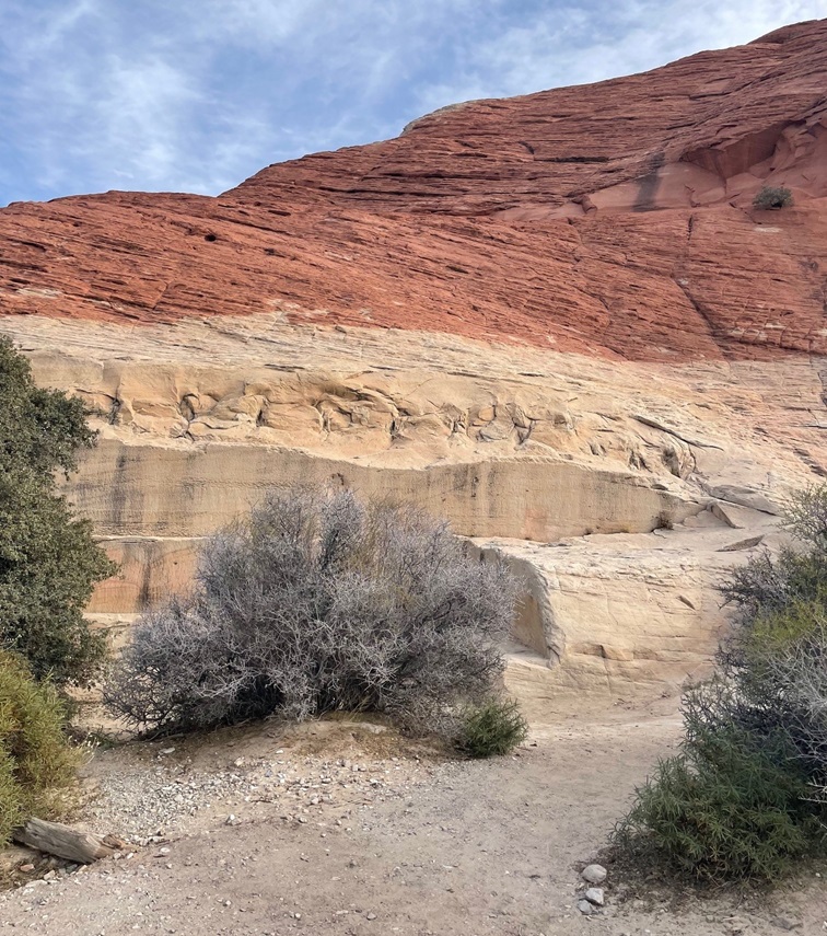
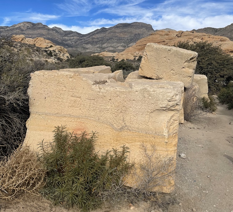
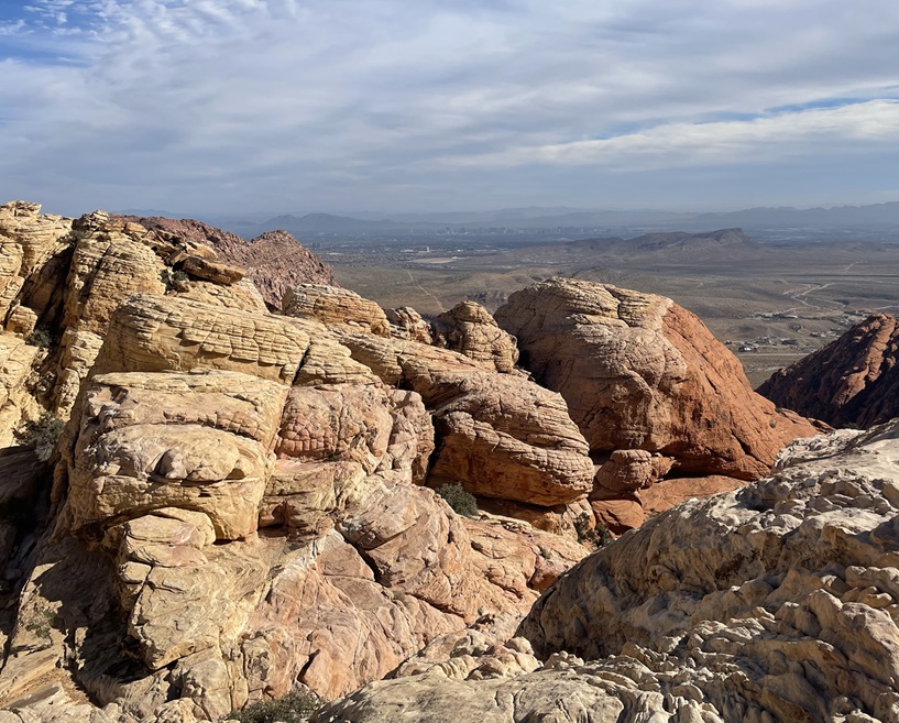
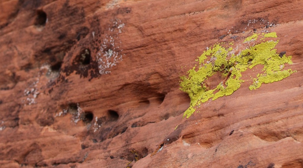
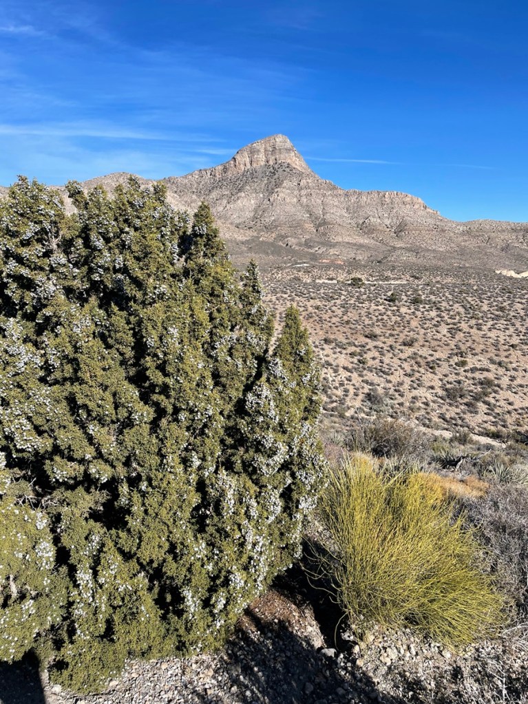
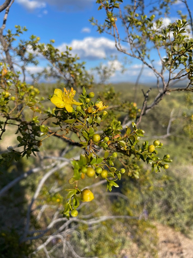
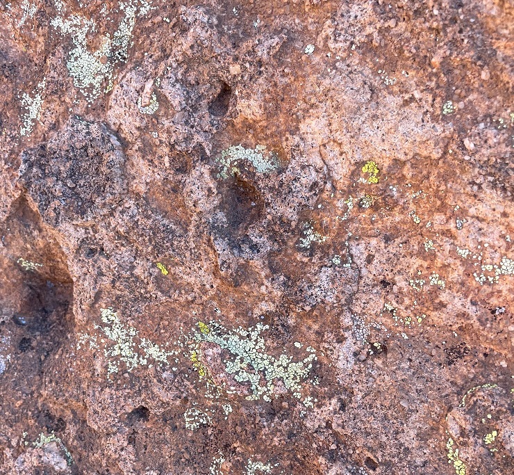
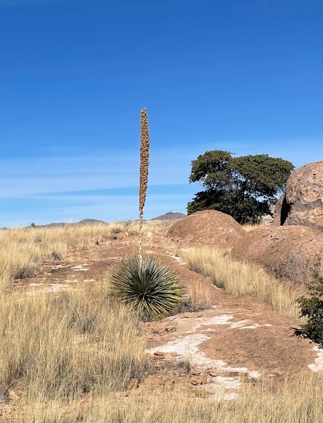
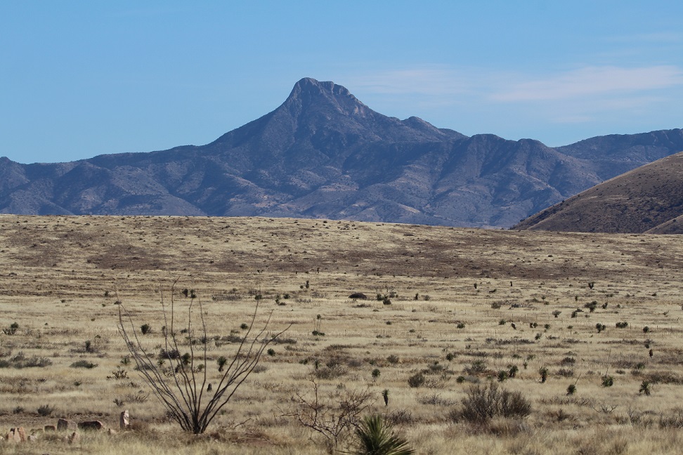
It’s easy to see how Red Rock Canyon got its name. The sand originally forming the dunes contained an abundance of minerals, one of which was iron that was oxidized by the elements over millions of years. The area began its federal protection in 1967, when the Bureau of Land Management (BLM) designated 10,000 acres as the Red Rock Recreation Lands. Further legislation over the years and significant additions of acreage eventually led to the National Conservation Area designation in 1990.I was struck by the clear delineation of colors in the rock. These two different colors of rock are both types of sandstone, but water moving through the sand at the bottom millions of years ago took away the red minerals and left behind calcium carbonate. The sand later developed, over even more millions of years, into sandstone.Erosional forces like water and wind result in some really cool-looking rock formations. Note, also, that the light-colored and red layers of rocks are the reverse of the photo above (and I didn’t post it upside-down).These huge sandstone blocks are not naturally formed: they’re remnants of one of the earliest industries in the Las Vegas area. The Excelsior Stone Quarry began operations in 1905, extracting blocks of sandstone for use as building materials. The blocks, some weighing up to 10 tons, were pulled with a 17-ton steam-traction engine to the just-built railroad in Las Vegas and loaded onto railroad cars bound for Los Angeles and San Francisco, where they served as decorative building material. While the sandstone was judged to be of exceptionally fine quality, quarries closer to California’s coastal cities were later developed and the Excelsior Stone Quarry and other operations in the area shut down for good in 1912. The plant growing in front of the large block is a species of yerba santa, which is Spanish for “sacred herb.” The name comes from the plant’s medicinal properties to treat respiratory and digestive ailments – even today, yerba santa extracts can be found in western U.S. herbal medicine stores.Part of the day included a hike on the Calico Tanks Trail. The long views and beautiful multicolored rock formations along the trail reminded Nancy and me of several places in Colorado, including Garden of the Gods in Colorado Springs and the Red Rocks Amphitheater near Morrison. Two hikers can be seen in the lower-left corner of this image. The BLM has classified the Calico Tanks Trail as “moderate”; I’d say, based on the elevation gain and necessity to scramble up and over rocks, it’s on the far end of “moderate.” It was a beautiful hike, though.These curves in the sandstone were created while the materials were still in the form of loose sand. Wind blowing across the dunes created these lifted layers before the grains of sand were cemented into the sandstone of today.This specimen of Spanish dagger (Yucca schidigera, also known as Mohave yucca) reminded us that we were in the desert. It, like many plants found in the Mohave and other deserts, looks pretty savage.Speaking of savage, Gunther takes a break on the Calico Tanks Trail to enjoy the scenery. He got along really well with the Canadians; he gets along really well with pretty much everyone, no matter their country of origin.This is the feature for which Calico Tanks Trail gets its name: a seasonal pond, or tank, created by water seeping or flowing into a depression in the sandstone (there was a much smaller water feature earlier in the trail, thus the plurality of the trail’s name). The Spanish word for this formation is “tinaja,” which means “clay pot.” The sun on this early December day was pretty low in the sky, making for some considerable shadows from the rock formations. Those of you who have been to Las Vegas will probably think this tank is the third-largest standing body of water in the area after Lake Mead and the fountains in front of the Bellagio resort on the Las Vegas Strip; I would not disagree with that assessment. Formations like this make possible a huge diversity of plant and animal life that otherwise couldn’t survive in the desert.If you squint, the hotels and casinos of Las Vegas can just barely be made out near the horizon in this image, taken at the end of the Calico Tanks Trail. This vantage point took some rock scrambling to get to; along with my phone, with which I took this and most of the rest of the photos in this posting, I was also carrying my digital camera with a large and heavy zoom lens in case we saw any wildlife. A fellow hiker noticed the camera and said I was brave for bringing it along; I corrected him and said I was dumb.So that I didn’t bring my heavy camera lens on the Calico Tanks Trail for naught, here’s a picture of a rock climber I took with it. Rock climbing is a pastime in which I have absolutely no interest in participating.Yeah, this looks like just heaps of fun. The BLM’s website states that rock climbing at the national conservation area is among the best in the world. Red Rock Canyon National Conservation Area is one of more than 850 areas managed by the BLM’s National Landscape Conservation System, which totals 27 million acres of areas designated as National Conservation Areas, National Monuments, Wilderness Areas, Wilderness Study Areas, Wild and Scenic Rivers, and National Historic and Scenic Trails.Longtime readers of this blog know that I won’t pass up an opportunity to post an image of lichen. I have no idea what species this is, but I think the shade of green is best described as “obscene.” Together with wind and moisture, plants and lichens do their part to erode the rocks into all kinds of fantastic formations.This is a view from High Point Overlook (elev. 4,771 feet) looking east toward the city of Las Vegas, which is 15 miles on the other side of the rock formation. High Point Overlook is just a little shy of the midway point of Red Rock Canyon’s scenic drive. The vegetation in the foreground gives an idea of what the flat parts of the area are like; it appears kind of sparse, but it’s much more heavily vegetated than other areas we’ve seen around Las Vegas. There are about 600 species of plants found in the conservation area, a number boosted considerably by the presence of year-round water: the sandstone allows water to percolate, creating springs, pools of standing water like the Calico Tanks, and even small creeks and waterfalls .This is Turtlehead Peak (elev. 6.323 feet), also photographed from High Point Overlook. There’s a trail to the top, but it’s 5 miles round-trip with a 2,000-foot elevation gain, and Gunther didn’t want to try it so we didn’t. That’s a heavily laden Utah juniper (Juniperus osteosperma) on the left, with Mormon tea (Ephedra nevadensis) growing at its base.I wasn’t planning to see any natural bodies of water in Red Rock Canyon National Conservation Area, let alone one that was flowing. This is Lost Creek, along which we saw a huge diversity of plant life flourishing in early December. I will remember this very short hike off the scenic loop for a couple of reasons: this stream, and the fact that Nancy bonked her head on a low-hanging ponderosa pine branch that was overhanging the trail; she didn’t see it because of her hat brim. If she hadn’t been in the lead of our hiking party, any of the other three of us would probably have bonked our heads (even though he was ahead of Nancy, Gunther didn’t bonk his head because he’s an expert hiker. And he was able to just walk under the branch, without making note of the obstruction to Nancy.) We’ve discovered that the maintenance of trails in the federal system can vary greatly; BLM trails are perhaps the most … rustic. It’s really not a problem, and I’m certainly not complaining. It’s just interesting to see.Here’s an example of the diversity of plant life in Red Rock Canyon National Conservation Area: a specimen of ashy silktassel (Garrya flavescens), growing along Lost Creek. I’ve never knowingly seen it before. It can grow up to about 10 feet high. Another short trail from the scenic loop leads to a grouping of petroglyphs and pictographs, created by native Americans thousands of years ago. The minerals in rock exposed to the intense desert sun over the millennia develop a dark patina called desert varnish. The native Americans removed the patina with stone tools to expose the lighter colors of the original rock beneath, creating designs known as petroglyphs. Pictographs, in contrast, are designs created with paints made with clays, charcoal, and other minerals, and then applied to the rocks.Here’s a closer view of the petroglyphs in the photo above this one. The meanings or significance of these designs have been lost to time; the only communicative records of the people who created these designs that still exist are the petroglyphs themselves. Nancy and I have seen quite a few petroglyphs in New Mexico and Arizona, but it was a bit surreal to see these ancient designs just 15 miles from the (barely) controlled 24-hour party of the Las Vegas Strip.Here’s an example of a pictograph, or an image painted on the rock, located just a few yards away from the petroglyphs. It’s a little hard to see in this photo, but petroglyphs and pictographs are themselves sometimes hard to see in the wild. There’s a closer view of the pictograph below.The pictograph looks like a figure 8 with a vertical line inscribed through it (it’s just to the right of dead center in the photograph above). Again, we have no idea what its significance is, but it must have been important to someone a very long time ago. The BLM and other federal agencies take great care to protect these cultural artifacts; like in other areas around the country, the precise locations of many of the pictographs and petroglyphs in Red Rock Canyon are not made available to the public. Six major groups of native Americans have lived in what is now Red Rock Canyon, beginning with the Tule Springs Paleo-Indian culture 11,000 to 8,000 years ago.
A visit to Red Rock Canyon National Conservation Area had been highly recommended by one of our Lyft drivers who happened to be a native of Las Vegas, and she was right to do so. I mean, we would have gone regardless, but our visit definitely blew past what I thought it would be like. I sure wasn’t expecting to see those incredible views, enjoy fascinatingly colorful rock formations, and go on a hike next to a running stream, let alone appreciate imagery left by native Americans thousands upon thousands of years ago, but Red Rock Canyon had all of that and more. If you do find yourself in the Entertainment Capital of the World and want to experience something completely unlike what Las Vegas is known for, Red Rock Canyon National Conservation Area is a wonderful place to spend a day.
Lake Mead National Recreation Area Near Las Vegas, Nevada – January 6, 2024
Impounded behind the concrete and steel of the magnificent Hoover Dam, Lake Mead in southeastern Nevada and southwestern Arizona is, by volume (and when full), the largest inland reservoir of water in the United States. There are a couple of U.S. reservoirs that have a larger surface area, but they don’t have the depth of Lake Mead (when full). The reservoir, made by the result of damming the Colorado River, is the primary feature of Lake Mead National Recreation Area – the nation’s first NRA as well as its largest at 1.5 million acres, or just over 2,400 square miles. For perspective, Lake Mead NRA is a couple hundred square miles larger than Kit Carson County in far eastern Colorado.
When full, Lake Mead has a surface area of 247 square miles, a surface elevation of 1,229 feet above sea level, and a maximum depth of 532 feet. When it’s full.
Lake Mead is, at the moment, not full. Not even close, really. In fact, it’s a couple hundred feet below its capacity, and it hasn’t been this empty since it was first filled after the construction of the Hoover Dam in 1937. A multi-decade-long drought in the southwestern United States, as well as unprecedented demand for agricultural and municipal water in the multi-state region served by the reservoir, have led to a stunning drop in the water level of Lake Mead. The reservoir’s capacity is so large that one inch of water in the lake equates to about 2 billion gallons. Two billion multiplied by 2,400 inches (200 feet) means Lake Mead has 48 trillion fewer gallons of water since the reservoir was last full in the mid-1980s. That number is so large as to be effectively useless, but in terms of acre-feet (which is the amount of water needed to cover an acre with 12 inches of water), Lake Mead is currently a little over a quarter of its capacity.
Geologists and hydrologists, along with other concerned -ogists, are working, and have been working for several decades, to address this issue. Many millions of people rely on Lake Mead’s water to continue flowing through the reservoir, providing electricity as well as drinking, municipal, and agricultural water. Mother Nature, while a powerful force in her own right, will take a long time to refill the reservoir: even after the remarkable upstream snowpack of the 2022-2023 winter in the Rocky Mountains, the reservoir rose only a few inches. It would take many consecutive decades of consistently above-average snowpack to refill the lake. That’s highly, highly unlikely to happen.
While the situation awaits a hopeful solution, that change in Lake Mead’s water levels also presents new opportunities for recreation: the receding water has left behind areas for great hikes. Recreation managers have developed at least 14 hiking trails all around the area, ranging from short and easy strolls to a 34-mile-long bike loop to strenuous hikes that are meant for the truly hardy among us.
Which neither Nancy, nor Gunther, nor I, are. We lucked into a great hike called the Owl Canyon trail on the first weekend of 2024, and saw some pretty cool sights while enjoying a 4-mile out-and-back trail.
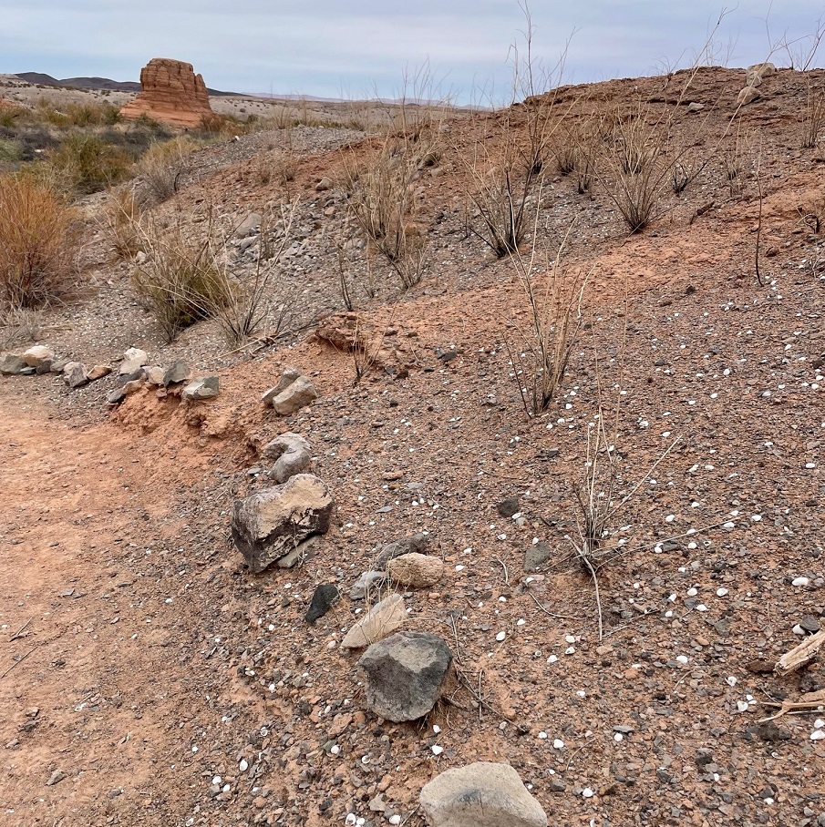
We saw several of these beautiful buttes along the trail to Owl Canyon. The creek flowing below the butte at lower left is Las Vegas Wash, a 12-mile-long arroyo that channels most of the excess water from the Las Vegas metropolitan area into Lake Mead. The wash contains water from urban runoff, reclaimed water from golf courses and parks, and stormwater; in short, it’s probably best to not dip your tin cup in it for a cool, refreshing drink – although the plants and rocks of the wash do filter a lot of the contaminants out of the water before it reaches Lake Mead. This photo was taken perhaps a half-mile from the trailhead, which was a boat ramp that used to provide watercraft with access to Lake Mead. More on that later.Thousands of these small white mollusk shells can be found in several locations along the Owl Canyon trail. They point to a time, years ago, when this entire area was covered by a vast body of water: Lake Mead, which, when it’s full is about 60 percent bigger than the area covered by the city and county of Denver. As recently as the 1980s, mollusks like these were free to frolic or fritter away their days or whatever it is that mollusks do. Now, every foot of the trail we were on is high and dry.
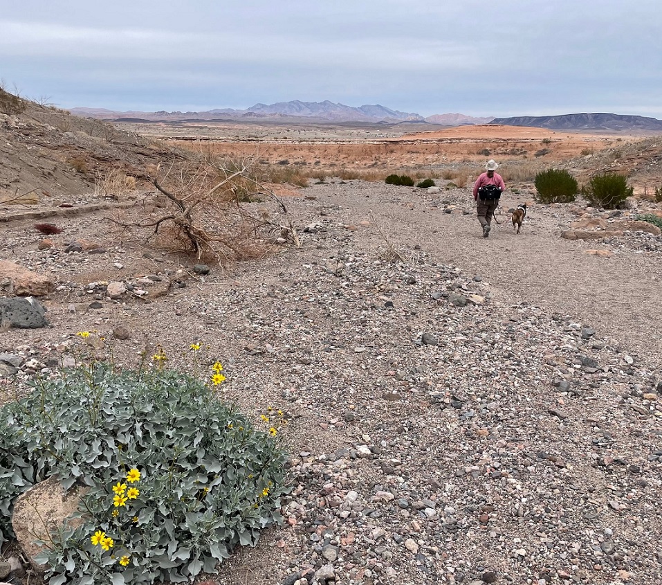
Here we see an intrepid hiker and her ill-behaved dog (it’s Nancy and Gunther) approaching the mouth of Owl Canyon, about a mile and a half from the trailhead on the boat ramp to the west. The canyon can also be accessed by a trailhead resulting in a shorter hike (2.2 miles out and back) coming from the northeast, but we wanted a bit more of a challenge for this first hike of 2024.
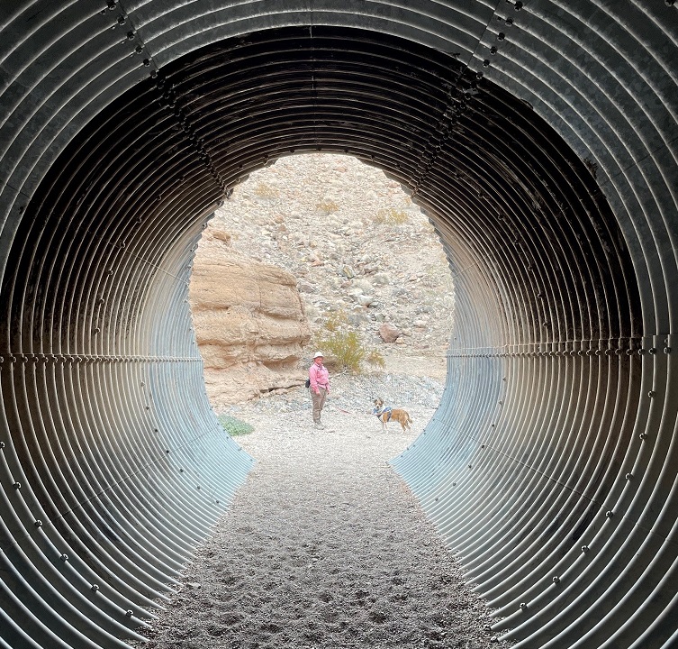
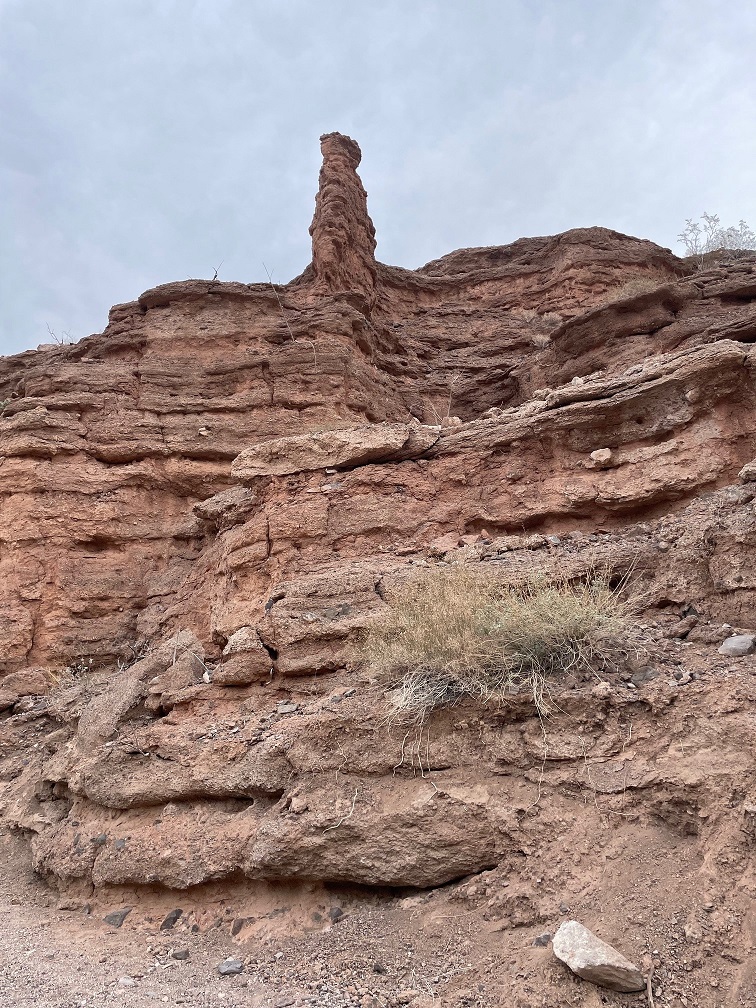
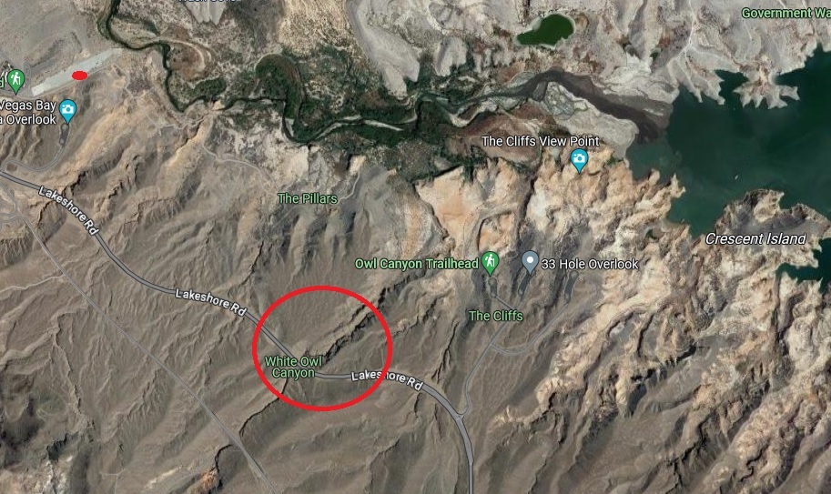
As you can probably tell from the earlier photos, it’s rather arid in the Lake Mead National Recreation Area (it’s in a literal desert, the Mohave, and the region is a convergence of the Mohave, Great Basin, and Sonoran deserts). Depending on which resource you use for reference, the area gets between 4 and 6 inches of precipitation each year. Except for a great blue heron, a small family of mallard ducks, and a large flock of goldfinches, we didn’t see much in the way in wildlife on the day’s hike. However, we did see some examples of desert plants that we hadn’t yet encountered on our travels. This is a specimen of desert stingbush (Eucnide urens), also known as velcro plant. It’s found in the desert regions of the southwestern United States and Baja California. It looks a lot like holly leaves seen around the December holiday, but, true to its name, the serrated leaves have stinging hairs to protect the plant from browsing animals. It’s yet another desert plant one wouldn’t want to lick (although the desert bighorn sheep native to the area seem to like them quite a lot).The walls of the canyon, which were under the waters of Lake Mead for many years, is made of a conglomerate of many different kinds and sizes of rocks, ranging from particles of sand to basalt stones the size of footballs or larger. Owl Canyon existed before Lake Mead; it was carved by an intermittent watercourse to create a winding natural path through the desert.The previous photo of the canyon walls’ conglomerate was taken near a spot in the canyon where we stopped for lunch. This photo was taken from the same spot. It shows Gunther alertly listening to Nancy about further instructions regarding the hike, especially to be constantly aware of impending threats from wildlife. (He’s really just waiting for Nancy to offer him some of her tuna salad sandwich; ultimately, he was disappointed to be denied the same.) The bandana he’s sporting around his neck was acquired gratis from a pet grooming service in Idaho over the summer; it looks like I neglected to iron it before we left on that day’s hike.Owl Canyon gets its name from the many holes in the rock walls that have eroded away, providing perches for owls and other roosting birds. Walking through its winding course was a ton of fun, although Gunther appeared to be ready to leave at any time.Of course, Gunther was right to be terrified. One drawback presented by the canyon’s winding rock walls was the inability to see anything around an upcoming bend, such as these remarkable multi-stone sculptures located just before a culvert in the canyon, until they suddenly appear before you. They were encountered on our return path through the canyon; they weren’t there when we walked through the culvert earlier and gave us something of a start. Their sudden appearance shall forever remain a mystery. (Seriously, a family also walking through the canyon must have put quite a bit of work into stacking these stones, and they did it in pretty short order. Park managers are strict when it comes to building even small piles of rocks: like graffiti on rock walls or otherwise defacing natural resources, despite how cleverly they’re designed, putting these formations together is forbidden.) That’s Lakeshore Road above the culvert.Here are Nancy and Gunther on the other side of the culvert pictured above. Walking through its galvanized confines as we hiked underneath Lakeshore Road was an interesting experience. I found, to Nancy’s delight, that it provided quite an echoing experience. There are two culverts in Owl Canyon; they allow seasonal water runoff to continue on its natural course through the canyon on its way to Lake Mead.Erosion from water and wind creates some spectacular rock carvings. Vertical formations like this, like the much larger butte pictured earlier, are created when the erosional forces of water and wind take away rock material surrounding a structure, but the formation itself is protected on its top by a layer of less permeable rock. I’d guess that this formation at the top of the canyon wall is 12 to 15 feet tall.Nancy and Gunther emerge from the canyon and prepare to return to the trailhead; Gunther, in particular, appears pretty happy to be out. That’s a brittlebush (Encelia farinosa) plant in the lower left, displaying its bright yellow blossoms on this early January day. Perhaps unsurprisingly, brittlebush is a member of the sunflower family.On our walk back to the trailhead, we saw this striking shrub we hadn’t noticed while hiking to the canyon. I inset a closeup of the plant’s leaves in the lower right. It’s a pretty plant, isn’t it, with its deep red limbs and attractive dark green and juniper-like leaf structures? Don’t be fooled! This is the scourge of the southwest, an invasive plant called tamarisk (Tamarix ramosissima) that’s native to Europe and Asia. Land and river managers throughout the southwestern United States spend a lot of resources trying to control the spread of tamarisk, the flowers of which each contain thousands of tiny seeds. Younger tamarisk plants compete with native plants for water along riverways; tamarisk doesn’t grow well in shade, so if the native plants are able to outgrow tamarisk (which can grow to heights of 25 feet in full sun and with sufficient water), the natives will usually win out. This particular plant was growing quite a ways from Las Vegas Wash.This is a view of the length of the boat ramp that now serves as a parking lot for a couple of hiking trailheads, including the Owl Canyon Trail. I took this photo as we were driving away from the trailhead. You can barely make out the white paint on a couple of vehicles parked on the right side of the ramp near its end. Las Vegas Wash is just beyond the end of the ramp. When the lake is full, a lot of this ramp would be underwater. Keep scrolling to see what it would take to get this boat ramp functional for launching boats into Lake Mead again.Here’s some perspective of how low Lake Mead is. This is a screenshot from Google Maps, using satellite imagery taken from about 250 miles above the earth, of the area in which Nancy, Gunther, and I hiked. The boat ramp pictured in the photo above this screenshot is the small gray strip in the upper left corner; we parked the Goddard’s six-wheeled towing unit approximately where the red dot is. Owl Canyon is in the red circle; we hiked from the boat ramp, to and through the canyon, and back again. Las Vegas Wash is the creek at the top of the image flowing into Lake Mead in the upper right corner; when the lake was full, it extended west all the way to cover a lot of the boat ramp on the left side of the image. In short, the end of the boat ramp is at least three miles from the current waters of Lake Mead, and the lake would still need to fill much more in order to actually launch a boat from the ramp. When we finished our hike we happened to meet an construction engineer on the boat ramp who was doing some preliminary evaluation to prepare for its eminent demolition and extraction of the concrete, rebar, and other materials. As he told us, “This lake isn’t filling in our lifetimes.”
It’s easy to think that it’s not the end of the world if Lake Mead continues to dry up: the Colorado River flowed freely through this area for millions of years, supporting all kinds of native plant and animal life. But that’s not the world in which we currently live, and the disappearance of Lake Mead would be an absolute catastrophe: without constant flowing water to turn Hoover Dam’s turbines, many metropolitan areas in the southwest, like Phoenix, Las Vegas, and Los Angeles (to say nothing of the many thousands of smaller cities in the region), would suffer calamitous losses of electricity as well as a reliable source of water. Simply put, water impoundments like Lake Mead (and, to lesser but still vital extents, Lake Powell and Blue Mesa Reservoir upstream) make habitation of the southwest possible. Ain’t nobody living in Phoenix or Las Vegas in the 120-degree temperatures of July without air conditioning provided by electricity, to say nothing of being able to turn a faucet and expect water to come out.
It’s sobering to think that every step we took on this hike was once well underwater in Nancy and my lifetimes. Fortunately, smart and committed people are working on ways to continue developing and encouraging water conservation in the American southwest, but committed people will also need to actually take those steps in order to keep water flowing through Lake Mead.
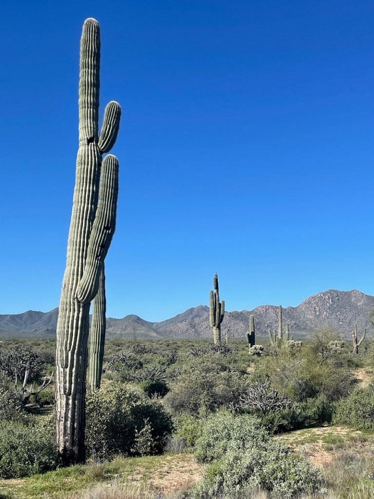
As I related in a previous posting, we spent two weeks of March 2023 in McDowell Mountain Regional Park, a huge protected expanse of land east of the Phoenix, Arizona, metropolitan region. While that posting approached the avian aspects of the park, this one will focus on the floral features of the McDowell Mountain area. Keep in mind that all of these photos were taken in the last two weeks of March, when much of the rest of the western United States was just beginning to emerge from winter. Since Nancy and I are both from Colorado, about the only flowers we’re used to seeing that early in the year are those of crocus, narcissus, tulips and other bulb-born blossoms. The blooms of these flowering plants of the Sonoran Desert provided plenty of color in a landscape that otherwise seemed to be generally green and brown, as seen in the saguaro landscape above. (By the way, if you’re a beer aficionado, in the background you will recognize the four mountain peaks used on the labels of the Tempe, Arizona-based Four Peaks Brewing Company. I’m suddenly in the mood for a Kilt Lifter.)
Like most of the western United States, the Phoenix area received an above-average amount of precipitation during the 2022-2023 winter. That, along with occasional rain showers while we were at McDowell Mountain in March, resulted in some spectacular wildflower displays.
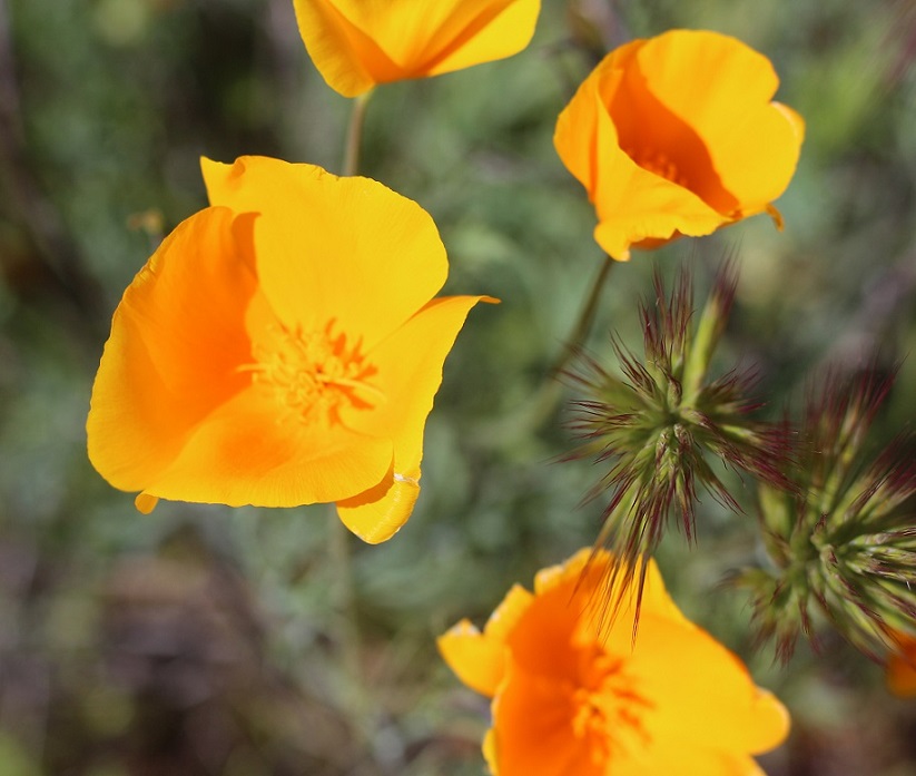
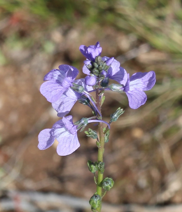
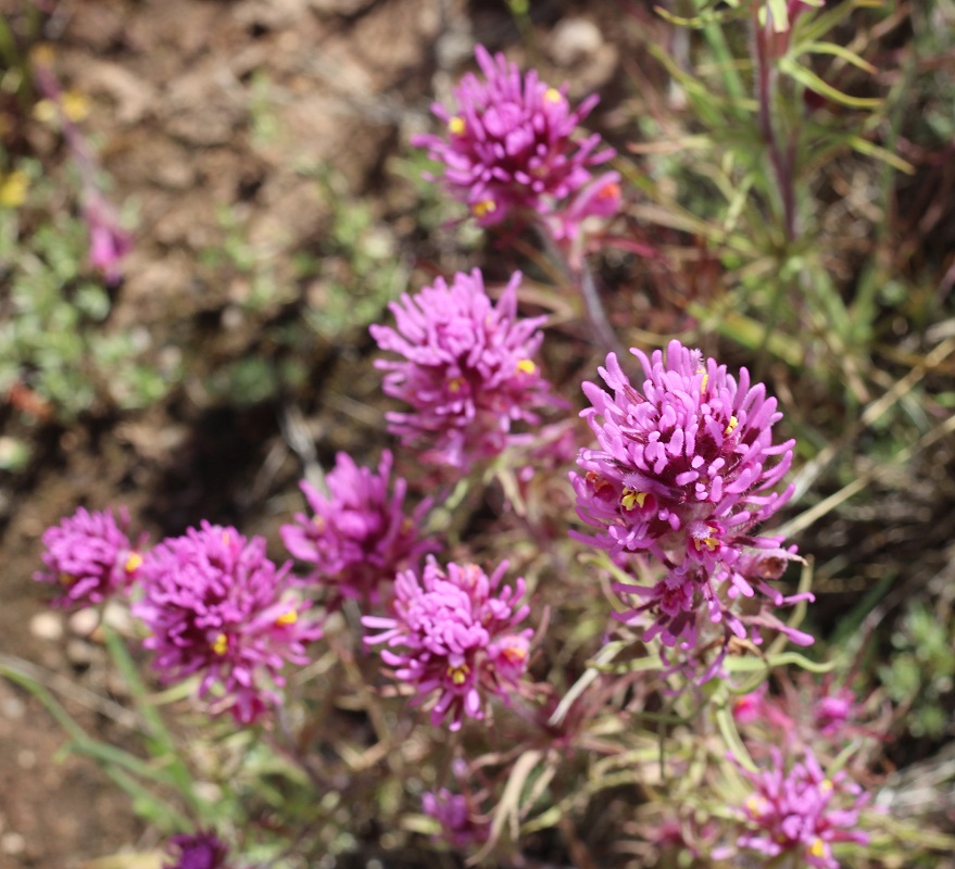
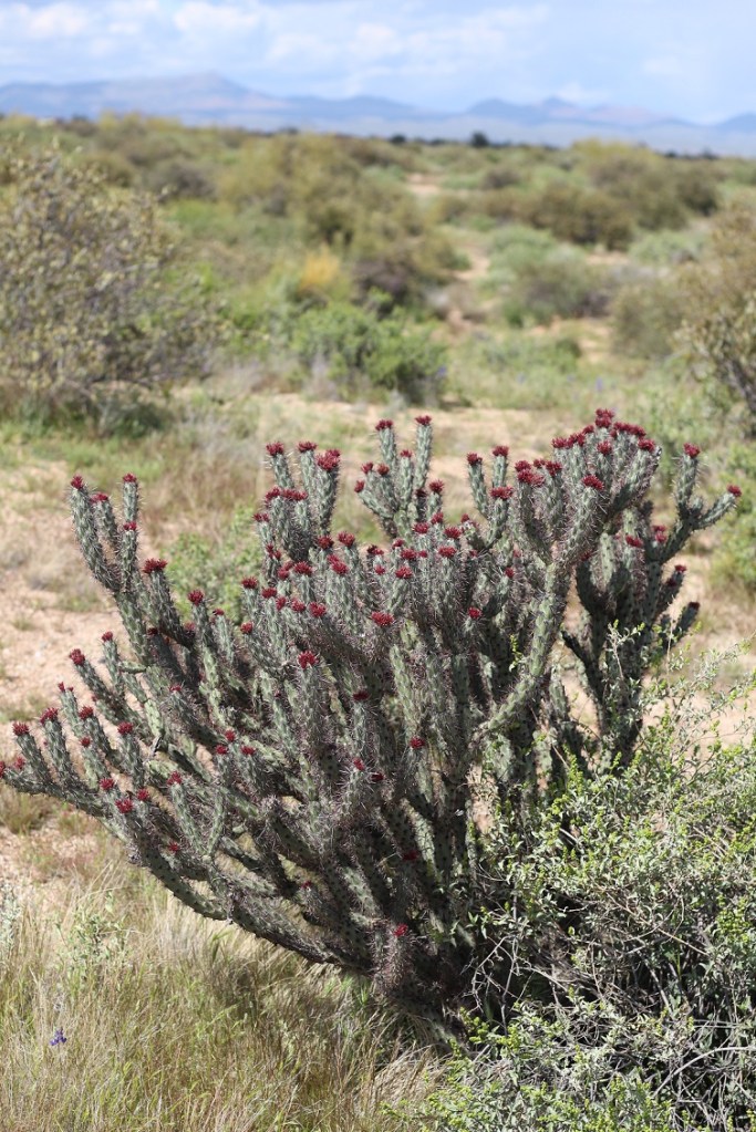
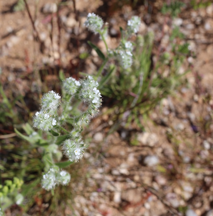
First up is the very common but colorful California poppy (Eschscholtzia californica), of which we saw plenty while in the park. It’s possible that this is another species called Mexican gold poppy, but I do think that, based on the flower coloration, this is the California species. The petals of these flowers close as evening approaches, and then begin to open again when the sun rises.California poppy plants grow to a height of 8 to 24 inches, and their blossoms can be 1 or 2 inches wide. I inadvertently planted a lot of this species in the xeriscaped part of our yard in Denver – the seeds were included in wildflower packets, and after a couple of years the poppies began to take over the area. Still, these plants produce some pretty eye-catching color. The California poppy is the state flower of … California.Texas toadflax (Nuttallanthus texanus), a member of the figwort family of flowers, grows to a height of about 28 inches. It’s a very spindly plant topped with some spectacular flowers that, because of their size, need some closer examination to appreciate; if you just walked by these flowers, it’d be easy to miss their delicate beauty.The bluish-violet color of this toadflax’s flowers is really pretty, I think, as is the complex structure of the blossom. The flowers grow on a structure called a raceme, a stalk in which the youngest flowers grow on smaller stalks at the top and the lower, older blossoms begin to develop into seeds.Castilleja exserta is one of about 200 species of Indian paintbrush found in western North America down through South America. Native to the southwestern part of the country, the plant grows to a height of 4-18 inches. Like all other Indian paintbrush species, exserta Indian paintbrush (also commonly called purple owl’s clover) is parasitic: it gets nearly all of its nutrition by using a specialized organ called a haustorium to attach itself to another plant species. Indian paintbrushes are some of my favorite plants; I tried to grow them at our Denver house next to some buffalograss for sustenance, but to no avail.Ocotillo (Fouquieria splendens) is a common plant seen from west Texas to southern California. They grow to an impressive height of up to 30 feet, and in the spring produce bright red flowers at the top of their many stalks. We were just a tad too early (or maybe too late; I’ve never seen ocotillo in bloom) to see these buds blossom. The flowers, which flower to coincide with hummingbird migrations for their pollination, give the plant its name: ocotillo means “little torch” in Spanish. Ocotillo are really interesting plants: they grow those tiny leaves seen in the above photo after a rainfall, and then drop the leaves when dry conditions return. It’s a cycle that can happen four or five times during the growing season.I think we were also at McDowell Mountain Regional Park too early in the season to see the saguaro cactus (Cereus gigantea) bloom, too. However, we did see some of these mighty cacti beginning to grow new arms, as seen on the left of this photo. Saguaros, which grow to a height of 50 feet, are very long-lived cacti: the oldest are estimated to be 200 years old. They don’t start forming arms like this until the plants are 70 to 100 years old, depending on the amount of precipitation they receive. Saguaro flowers, which grow at the top of the cactus, are white and grow to a width of 3 inches. The blossoms open at night and are pollinated by a variety of insects as well as bats. Saguaro blossoms are the state flower of Arizona.You wouldn’t guess it by looking at Esteve’s pincushion (Chaenactis stevioides), but this pretty plant is a member of the sunflower family. Reaching a height of 4 to 10 inches, it grows across the western United States, from southern Oregon and Idaho, down to New Mexico, and east to Wyoming and Colorado.The park had a lot of buckhorn cholla (Cylindropuntia acanthocarpa) in bloom; these large cacti seemed to be popular perches for birds. Buckhorn cholla cacti, of which there are six varieties, are found in the Sonoran, Mojave, and Colorado deserts of North America.I’d think a bird would find a more comfortable place to perch than on the top of a buckhorn cholla (pr. CHOY-ah), but I suppose they know what they’re doing. We had a different species of cholla along a south-facing exterior wall of our house in Denver; I’ve no idea what species it was (it wasn’t as branching as a buckhorn), but it had pretty flowers in the spring as well.I think of all of the flowers in bloom while we were at the park, desert globemallow (Sphaeralcea ambigua) was probably the most prevalent. It’s the orange-colored flower on the left, and the plant is still used by members of the Shoshoni and other Native Americans as a food and medicine source. It’s very common in Arizona; at another camping spot in the extreme northern part of the state later in the year, we’d drive by fields of it in which the blooms probably numbered in the millions. It is a popular cultivar for home xeriscaped gardens. The yellow flower on the right is brittlebrush (Encelia farinosa), which we first encountered at southeastern Arizona’s Gila Box Riparian National Conservation Area in January 2022. Its growth habit varies widely; it can be a foot tall or grow to a height of 5 feet.Here’s a closer view of the brittlebush flowers. It derives its name from the delicate nature of its flower stems. The plant’s sticky sap lent itself to a wide variety of uses among Native Americans and early pioneers in the southwestern United States, including as a glue, a sealant, and a waterproofing agent. It, along with the desert globemallow, was everywhere in the park. The plant is commonly found in the southwestern United States and northern Mexico.While its flowers are attractive enough, I really liked the foliage of redstem stork’s bill (Erodium cicutarium). This is not a native of the southwestern United States; it was brought to this country in the 1700s from the Mediterranean region of Eurasia and northern Africa. This plant has an interesting seed distribution system; in a process known as explosive dispersal, part of the flower changes its shape into something of a coil and stores up elastic energy. When enough energy has been created, that part of the flower, including the seed, bursts away from the plant. Once on the ground, the part of the flower containing the seed waits until soil conditions become wet enough for it to bury itself into the ground and germinate.Here’s one more cactus, the teddybear cholla (Opuntia bigelovii) that, again, was not in bloom while we were at the park (the yellow-green flowers are a couple of inches wide). I took this photo after a brief late-afternoon rain shower and liked the lighting. Despite its name, this is not a plant you’d like to even get close to: its small joints will readily detach from the main plant at the slightest touch (it’s also known as jumping cholla), and the spines have backward-facing barbs to ensure that they stick. On walks around the park with Gunther, we’d see a lot of these cacti with little balls of spines at their bases. Teddybear cholla grow to heights of 3 feet up to a truly terrifying 9 feet.Let’s move on to something less threatening. Here’s panamint cryptantha (Johnstonella angustifolia), also known as panamint catseye. It’s native to the southwestern United States and northern Mexico. It grows to a height of 2 to 12 inches, and is an annual wildflower – the plant produces flowers which develop into seeds, and, although the original plant dies, those seeds produce new plants the following growing season. In a very harsh desert landscape filled with plants covered in thorns, spikes, barbs, needles, and other sharp things, it was nice to find a relatively soft-looking flower.To wit: even this Menzie’s fiddleneck (Amsinckia menziesii) has small barbs on it (to say nothing of the thorns of the neighboring fishhook cactus in the lower left). Its seeds are a favored food for goldfinches (who’d have to be pretty hungry to get past the cactus thorns). The flower head of a fiddleneck sometimes curls gracefully into the shape of the head of a violin, giving the plant its name.I’ve enjoyed seeing the creosote bush (Amsinckia menziesii) in our travels around New Mexico and Arizona, and it was neat to see one in bloom. The smell of a creosote bush, especially after a rain, is really wonderful. A creosote bush creates clones of itself as it grows older – typically around the age of 60 to 90 years. Eventually the interior original plant dies, but it is surrounded by a ring of its clones. A ring of creosote in California’s Mojave Desert, called “King Clone,” is estimated to be nearly 12,000 years old – it’s one of the oldest organisms on the planet.I’ll close with this image of a fairy duster (Calliandra eriophylla) that I took perhaps 20 yards from the Goddard’s campsite. Fairy dusters, which grow to a height of between 8 and 20 inches, are fairly ho-hum shrubs for most of the year, but they produce some spectacular flowers in the spring.
There are several more photos I could include, but I think this posting has shown the incredible variety – the color, the blossom structure, the life cycles – of flowering plants in the Sonoran Desert. As was the case with the birds of McDowell Mountain Regional Park, I was really struck by the tremendous depth and breadth of the flower species variation. To be sure, the desert doesn’t look like this year-round, and it had been an especially wet winter and early spring, but under the right conditions a walk around the Sonoran Desert can be incredibly rewarding – as long as you don’t walk into a teddybear cholla.
Much of the identification of these plants was made possible by referencing the National Audubon Society’s Field Guide to North American Wildflowers, Western Region (ISBN 0-394-50431-3). Additional information came from Wikipedia, which I lean on pretty heavily for a lot of what I write – if you use Wikipedia much at all, please consider supporting it. I recognize that it’s not the end-all, be-all of sourcing information, but it’s a great starting point as a resource and available to everyone with an Internet connection.
The Goddard spent a few weeks in far eastern Idaho – about 30 miles from the Wyoming border – during the waning days of summer 2023. Ririe Reservoir, built in 1970 by the U.S. Army’s Corps of Engineers (CoE), impounds Willow Creek as it flows toward its entry into the Snake River near Idaho Falls. The reservoir has a surface area of 6.1 square kilometers (1,500 acres), about the size of Colorado’s Chatfield Reservoir at normal pool.
We camped at Ririe Reservoir long enough to see some of the cottonwood leaves change to their autumnal colors. This pavement is what I came to call “Raptor Road” because of the frequent sightings of hawks and falcons atop the utility poles (there were, unfortunately, no raptors atop the poles when I took this photo on the morning of September 8). That’s a potato field on the horizon.
Juniper Campground serves the reservoir, and, as is usually the case with CoE-built facilities, it’s outstanding. We spent most of our time at the reservoir camped in a site that had a great view of the reservoir through the Goddard’s back and side windows. We were there for Labor Day weekend and, although the Saturday and Sunday of the weekend proved to be pretty chilly and wet, we think the families who filled up the campground still had a great time.
The campground’s stands of native juniper trees, along with planted aspen, cottonwood, and chokecherries, support an outstanding wildlife habitat. The shrubs and trees provide food and shelter for birds, squirrels, and rabbits. I managed to take a few (hundred) photos of birds in the weeks that we were at Ririe Reservoir, and a lot of the pictures featured birds of prey perched atop utility poles (thus the title of this posting).
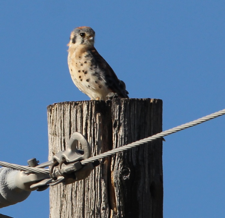
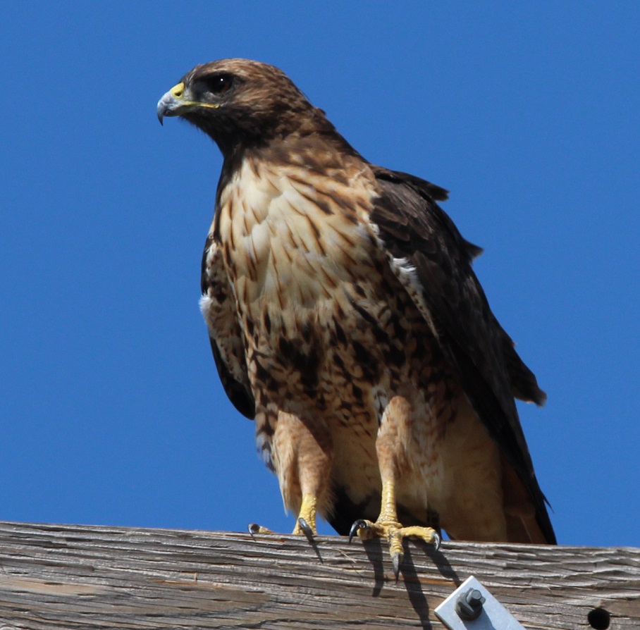
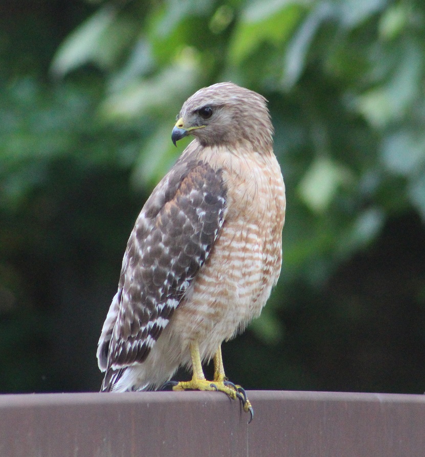
I was really happy to get some photos of this American kestrel (Falco sparverius) – it’s a species I’ve been wanting to photograph for many years. Their plumage, especially on their heads, is just so pretty. Kestrels are the smallest raptor in North America, weighing only about 5.5 ounces and measuring up to a foot in length, with a two-foot wingspan. Size- and weight-wise, they’re roughly the size of an American robin although their wingspan is much longer. They are found all over the United States, Canada, and Mexico, as well as much of South America. Like other raptors, they can see in ultraviolet light – which allows them to see a urine trail from a rodent. Kestrels also eat a lot of airborne insects, and will commonly patrol a well-lit football or baseball field in search of bugs attracted by the lights. They are fierce little birds, to be sure, but because of their size they’re also prey for other, larger raptors. We saw plenty of these magnificent red-tailed hawks (Buteo jamaicensis), both on power line poles and in the air, which makes a lot of sense because they are the most common hawk in North America. They’re found all over the United States and most of Canada. Red-tailed hawks grow to a length of 22 inches, with a weight of about 3 pounds and a wingspan measuring more than 4 feet. They have a very distinctive call, so commanding that Hollywood productions use the call whenever any bird of prey, whether it’s a bald eagle or an actual red-tailed hawk, is shown on screen (soundfile below). Red-tailed hawks are remarkably long-lived: one banded individual lived for at least 30 years in the wild.
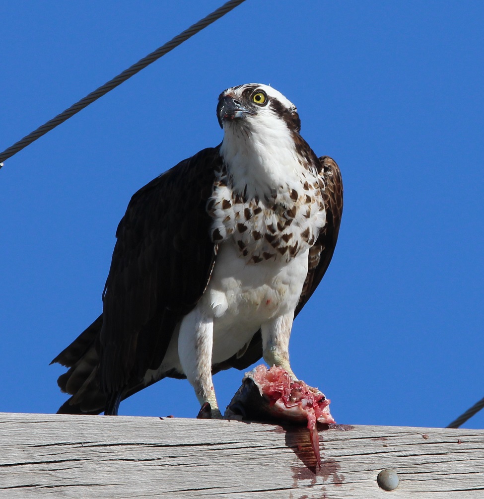
WARNING! The next photo shows a bird eating a fish; if you get squicked out by the sight of mildly bloody things, you may want to consider scrolling past the picture with some haste.
I saw this osprey (Pandion haliaetus) atop a power pole with its sushi breakfast mid-morning while I was driving to the town of Ririe on some errand that I’m sure was important. I was happy I’d thought to bring along my digital camera, because although we’d seen plenty of these birds during our stay I hadn’t gotten a picture. Ospreys weight about three pounds, with an impressive wingspan of 5 1/2 feet. Ririe Reservoir contains rainbow and cutthroat trout, kokanee salmon, smallmouth bass, and yellow perch. It’s difficult to tell what this unfortunate fellow was.
Ospreys are supremely adapted to support their diet of 99% fish (I don’t know what the 1% is; maybe like all of us, they break down about once a year and get a Big Mac): uniquely among raptors, two of their rear toes are reversible to allow them to carry fish with two toes in front and two toes in back. Their feet also have barbed lobes to aid in the grasping of fish, and they fly with their catch facing head-on to decrease wind resistance. Over the course of several studies, researchers found that ospreys are successful in catching a fish about 25% of the time. They are found all over the world, with the exception of Antarctica. Osprey were seriously endangered until DDT was banned, and their numbers have since strongly rebounded. These birds typically have a lifespan of about 20 years.
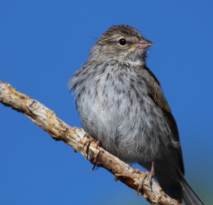
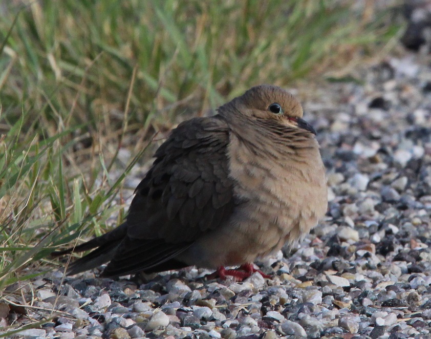
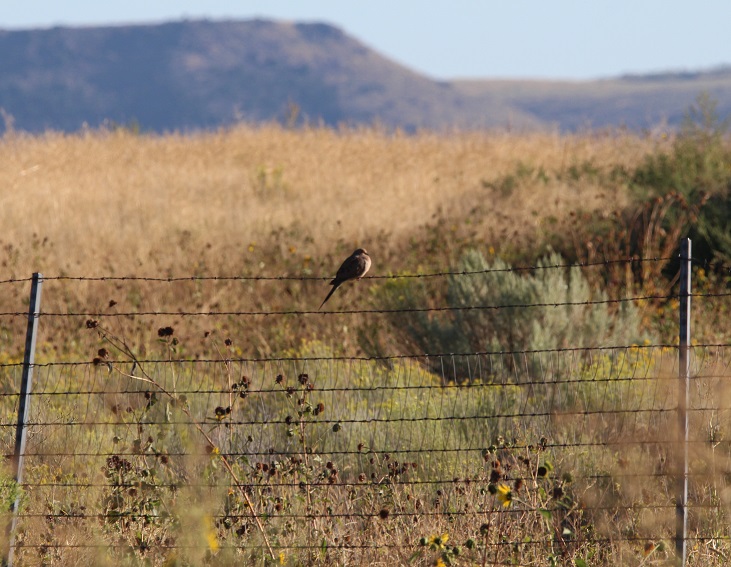
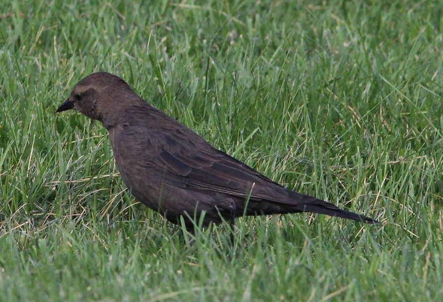
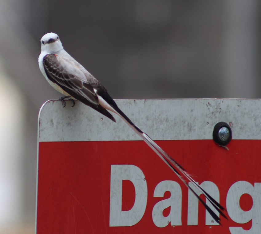
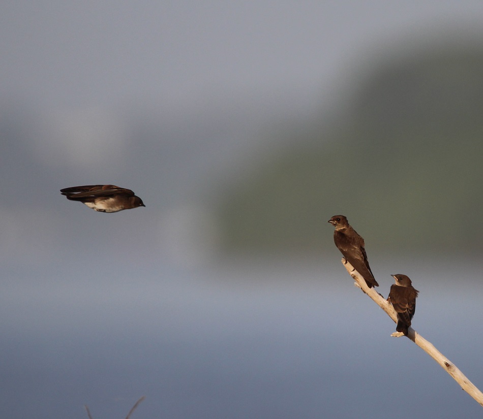
Of course, there were birds perched on things other than power poles at Ririe Reservoir (and apologies for anyone expecting more utility pole content; the title of this posting is probably misleading). Here’s a chipping sparrow (Spizella passerina) enjoying a quiet morning while perched on a cottonwood limb. The easiest way to tell a chipping sparrow apart from the other several billion brown-and-white sparrow species is the presence of a dark horizontal line through their eye. Male chipping sparrows have a handsome ruddy-brown cap atop their heads. This species is found throughout the United States, although they’re found in the center of the country only during their migration.This pretty bird sitting atop a juniper tree is a female American goldfinch (Spinus tristis). In the waning days of summer, the plumage of these birds is starting to molt into its winter colors. Goldfinches are unusual among most birds in that they molt twice each year: once in late winter and again in late summer.When birdwatching, I usually have my eyes trained at the tops of trees. Nancy spotted these male American goldfinches from a window in the Goddard, and I stuck my camera out the front door and snapped a couple of photos. We’d just had a brief rainshower in the campground, and these guys were looking for seeds on the ground. Goldfinches are purely vegetarian birds; they eat predominantly grass and flower seeds, and insects only inadvertently. There’s a species of bird called the brown-headed cowbird that lays its eggs in other species’ nests and lets the new parents raise their young (and the cowbird hatchings often crowd or starve out the real hatchlings because cowbirds are much bigger). In the case of goldfinches, cowbird hatchlings usually die a few days after hatching because they can’t survive on the all-seed diet that the goldfinch parents bring to the nest. Note that, like the female goldfinch above, these two fellows also appear to be in the process of molting for the winter.More birds on the ground: while on a morning walk with Gunther down Raptor Road, I saw this mourning dove (Zenaida macroura) on the roadside and bundled up against the chill of the early day. I feared it was sick or injured, but it flew off shortly after I took this picture. You may have heard a whistling sound when a dove flies off; that’s not coming from their beak, but from the beating of their wings. Doves spend a lot of time on the ground gathering seeds, and can eat 20 percent of the body weight (the birds can weigh up to 6 ounces) in seeds every day. This is the most frequently hunted gamebird in North America, but the current population is estimated to number 3.5 million birds (more than one mourning dove for every person in the country). I really like the pale blue ring around mourning doves’ eyes.Mourning dove, elevated (and a shout-out to all the barbed-wire aficionados).Lots o’ ladies in this particular blog posting. This is a female Brewer’s blackbird (Euphagus cyanocephalus) hunting for breakfast in the grass near a campsite. These birds (the males are definitely black, with a startlingly bright yellow eye) are fairly sociable and help reduce insect populations near human habitations. Blackbirds also eat a lot of seeds. They can gather in flocks numbering up to 100; we didn’t see any gatherings that big, but we did see lots of these birds.
We also saw black-billed magpies and an eastern kingbird during our time at Ririe Reservoir. The new species that we saw at the reservoir brought our total species count for the year, through early September, to 87 – the number with which we ended the calendar year 2022. We also saw a lot of utility poles, but I haven’t been keeping track of those. Will we reach 100 species of birds seen in 2023, with more than 3 months left to go? No one can say. However, we’ll be spending quite a few weeks in parts of the country in which we haven’t yet stayed, so it’s very possible.
I should probably include a picture of Ririe Reservoir in this posting, so here’s one with a friendly dog (it’s Gunther, on one of his security patrols around Juniper Campground; everything checked out on this walk). We’ve stayed at more than 60 public and private campgrounds in the nearly two years since we began full-time RVing, and Ririe Reservoir’s Juniper Campground is definitely in our top 5 favorites. Between the opportunities for wildlife watching, enjoying the quiet environment (the dark skies at night allowed for some incredible stargazing), and easy access to a number of attractions in the area, this campground really impressed us.Alright, one more utility pole photo, at sunset, with a center-pivot irrigation system on a potato field, some beautiful Idaho mountains, and an osprey.
The Bear River, at 350 miles long, is the country’s longest river that doesn’t eventually reach an ocean – but it is the largest river that flows into the Great Salt Lake of northern Utah. It starts in northeastern Utah, flows into southwestern Wyoming and southeastern Idaho, then makes its way back into Utah and into the Great Salt Lake.
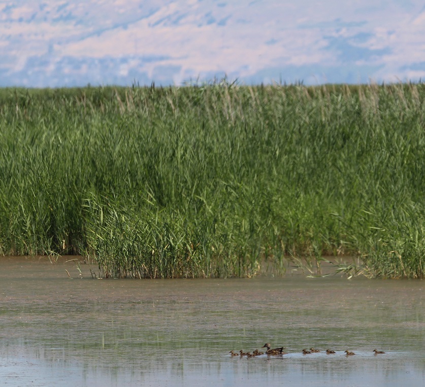
I took this photo looking east from an observation platform along the Bear River, a few miles before it enters the Great Salt Lake. The Wasatch Mountain range, forming the western edge of the Rocky Mountains, is on the horizon; Box Elder Peak (elev. 11,101 feet) and Willard Peak (9,763 feet) are two of the prominent mountains in this part of the Wasatch range. As in many areas of the west, the 2022-2023 snow season was quite robust in the Bear River drainage and provided plenty of water flowing into the lake in mid-July. More on that later, though.
This family of gadwalls (Mareca strepera), a species of duck that, thanks in no small part to the establishement of wildlife refuges, has been growing in numbers since the 1980s, is making its way down the Bear River. Female gadwalls closely resemble female mallard ducks, but their heads and bills are shaped differently. This mom is tending to at least 11 ducklings; gadwalls can lay up to a dozen eggs in one clutch. In the fall months, 500,000 ducks and geese can be found at the refuge during their migration southward. Imagine all of that quackin’ and honkin’!
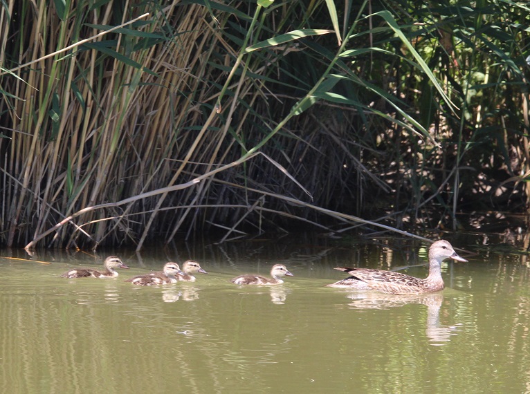
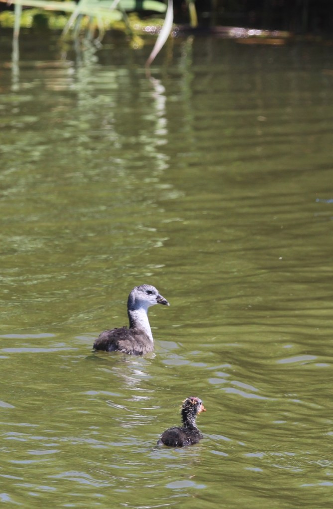
Here’s a closer look at another, and perhaps more reasonably sized, gadwall family. The gadwalls weren’t the only bird species looking after young ones at the Bear River refuge: there were baby waterfowl and shorebirds aplenty.To wit: this western grebe (Aechmophorus occidentalis) and two fledglings (grebelings?). Like many waterfowl, young grebes will often hop on a parent’s back to take a break from paddling. A volunteer at the refuge’s visitor center had suggested that we keep an eye out for the freeloading young grebes, and we were happy to see this family. The plumage of western grebes and that of their closely related cousins, Clark’s grebes, is very dense and their hides were used to make waterproof garments in the 19th century. Thankfully, the popularity of the style dropped and populations of both species, which had declined, soon recovered.More baby waterfowl, this time an American coot (Fulica americana). I had only ever seen black coots before and assumed that the lighter colored ones (like the one at the top of this photo) were females. In fact, both male and female adult coots are black, and so the larger coot here is either mother or father to the cootling but has not yet matured out of its juvenile color pattern. Coots were everywhere in the refuge: I’m going to guess that we saw about 70 kajillion coots that day.
The delta at which the Bear River flows into the Great Salt Lake is where the 74,000-acre Bear River Migratory Bird Refuge was established in 1928. The refuge provides critical breeding and nesting habitat to more than 250 species of birds and other wildlife. Nancy, Gunther and I visited the refuge in mid-July, enjoying a short hike, a 12-mile auto tour, and the company of thousands upon thousands of birds.
We’d seen white-faced ibis (Plegadis chihi) only once before, at St. Vrain State Park in northern Colorado, and that was a flock in flight and so far up in the sky that I thought they were Canada geese until I took a closer look at the photo. There were plenty of these beautiful birds on the ground at Bear River National Wildlife Refuge. They use their distinctive curved bills to dig in the wet dirt around waterways in search of earthworms and other invertebrates. I look forward to getting better pictures of white-faced ibiseses(es) sometime: their purple, green, and bronze plumage is really pretty.
The Bear River Migratory Bird Refuge is located where two of the country’s major migratory flyways, the Pacific and the Central, overlap. Because of its connection to the ecosystem of the Great Salt Lake, the refuge is a critical stopover for migratory birds of all sizes.
Administered by the U.S. Fish & Wildlife Service, the National Wildlife Refuge system includes more than 550 refuges in all 50 states and territories. In all, more than 150 million acres (almost 235,000 square miles, or more than twice the size of Colorado) are protected to support more than 700 bird species and 220 mammal species, along with hundreds of amphibian, reptile, and fish species.
Due to the loss of habitat from population growth, as well as a botulism outbreak, Utah citizens and conservation organizations asked Congress to protect this area, and the national refuge was created in 1928.
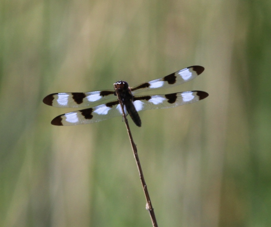
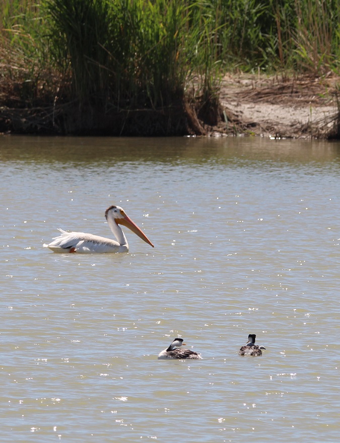
This black-necked stilt (Himantopus mexicanus) was yammering away while on the hunt for something good eat on the shoreline. The refuge is home to 65,000 black-necked stilts in the fall months. This species is closely related to American avocets, and, although it’s rare, the two can create hybridized offspring called “avo-stilts.”Ready for a break from birds? How ’bout a bug? This is a twelve-spotted skimmer (Libellula pulchella), a type of dragonfly. It was resting on a reed in a marsh next to the refuge’s visitor center. This is a very common dragonfly and is found in all 48 of the contiguous states. If you only count 10 spots, that’s okay – they’re also called ten-spotted skimmers. They’re one of the bigger dragonfly species, at up two two inches long and with an even longer wingspan. Insects like this are, of course, a major component of a wildlife ecosystem. Dragonflies eat smaller insects, and they themselves are eaten by birds and reptiles.To wit (again): this house sparrow (Passer domesticus) with a late breakfast on the visitor center’s roof (it looks like it has an unfortunate grasshopper rather than an unfortunate dragonfly in its beak, but you get the idea). The most common birds in the United States – house sparrows, rock pigeons, and European starlings – are all introduced species. None are native to this country, but they did remarkably well for themselves once they got into the wild.Here’s a native sparrow species, the song sparrow (Melospiza melodia). This species is found from Alaska’s Aleutian Islands to the country’s east coast. The coloration of their feathers varies depending on the conditions in the local population’s habitat.The variation in bird species we saw was pretty remarkable. Here are two western grebes pondering an American white pelican (Pelecanus erythrorhynchos), one of the largest birds in North America. We didn’t see many pelicans during our visit, and those we did see were pretty far away. This photo was taken in the delta area of where the Bear River enters the Great Salt Lake.Here’s another big white bird: the snowy egret (Egretta thula). During the breeding season, snowy egrets develop very thin feathers on their necks. These feathers were once highly valued by the fashion industry: in the 1880s, they had a per-ounce value twice that of gold. Naturally, the numbers of snowy egrets dropped precipitously, but conservation efforts, including the establishment of national wildlife refuges, helped restore the population. Check out those yellow feet! This egret was kickin’ it with a small herd of cattle, probably looking for insects and other invertebrates disturbed by the bovines. Back to bugs, briefly. There are about 3,000 known species of dragonflies in the world, and we saw three of them at the wildlife refuge. This one is a blue dasher (Pachydiplax longipennis), and like other dragonflies, is capable of eating hundreds of smaller insects every day.One more dragonfly; this is a variegated meadowhawk (Sympetrum corruptum). This species, native to North America, has been found migrating south to Honduras and as far as eastern Asia.Of the 256 photos I took at the refuge (I’m not kidding), this one is my favorite and it might be my favorite that I’ve taken this year. It’s an American avocet (Recurvirostra americana), and I took this picture after crawling slowly and steathily through a half-mile of stinking wet marshland in an attempt to unobtrusively approach this bird. I’m just kidding iwth you right now: I took this photo from the passenger seat of the Goddard’s six-wheeled towing unit while the avocet was walking down the side of the road. Avocets use their gently curved bill to sweep through shallow water in search of invertebrates. The plumage on their head and neck darkens to this beautiful russet during the summer, and then retreats to white and gray during the winter. They grow to about 18 inches tall. What an elegant bird.Here’s another photo I took from the passenger seat of our pickup. Gunther has enjoyed several auto tours with us this year, and we were happy to have him along at the wildlife refuge. He’s taken a special interest in seeing horses from the back seat.
About the water issue I alluded to at the beginning of this post: while the Bear River seemed to be flowing at or near the capacity of its banks thanks to a great snow season in the Rocky Mountains, the Great Salt Lake is undergoing an historic multi-decade drought that has shrunk the lake to just 37 percent of its former volume. It’s something that’s happening all over the western United States: higher temperatures coupled with decreased annual precipitation levels, exacerbated by growing populations of people, are creating smaller river flows and diminishing bodies of water. What’s happening at the Great Salt Lake specifically is a crisis that, in my mind, isn’t getting nearly enough attention: in addition to the critical wildlife habitat that would be lost, a dry Great Salt Lake bed would create a huge volume of toxic dust directly adjacent to Salt Lake City. It’s a metropolitan area of 1.3 million people, and one that is growing quickly.
The consequences of losing the Great Salt Lake are difficult to imagine, and I don’t even want to consider what life around Salt Lake City would be like. Conservation efforts, meant to reduce the amount of water taken (mostly for agricultural purposes) from the Great Salt Lake’s three tributaries prior to entering the lake, are underway. The Church of Jesus Christ of Latter-day Saints, one of the west’s biggest land- and water-rights holders, has taken the unprecedented step of donating a sizable amount of its water to the lake, and is encouraging its adherents to conserve as much water as they can, but it may be a case of “too little, too late.” The 20,000 acre-feet of water donated by the Mormons, while a significant amount on its own, is enough to replace only about 2 percent of the lake’s lost volume.
We saw 19 different bird species in about four hours while at the refuge. All of those species, and all of the other birds and other animals at the refuge, are dependent on healthy waterways to breed and raise their young – in other words, to continue as a species. I hope that happens, for all of them.
McDowell Mountain Regional Park is one of 14 parks in Maricopa County that have been preserved as open spaces and protected against private development – an important consideration for the Phoenix metropolitan area, one of the fastest-growing parts of the country. Some of the regional parks offer camping, and the Goddard spent two weeks in March in the shadow of McDowell Mountain, surrounded by saguaros and sparrows – along with a surprising diversity of other plants and birds.
Here’s a look at some of the Sonoran Desert birds we saw during that two-week stay. I was expecting to see at least some birds, but I wasn’t expecting to see some of the species that we actually did, nor the quantities of birds and different bird species that we saw. Keep in mind that most of these pictures were taken very close to our campsite – some were taken from our fifth-wheel’s steps – and all were taken no more than a quarter mile away from the Goddard.
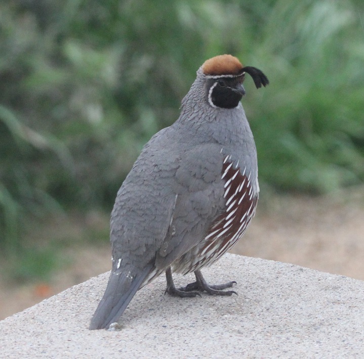
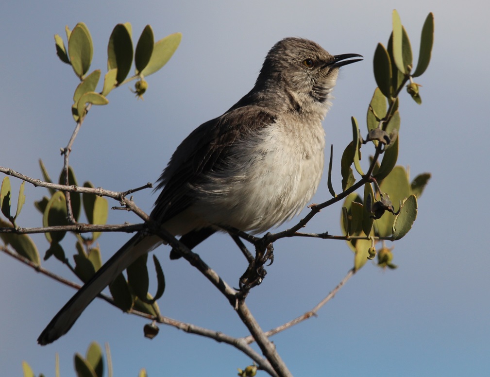
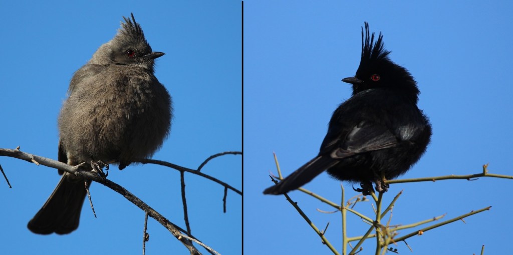
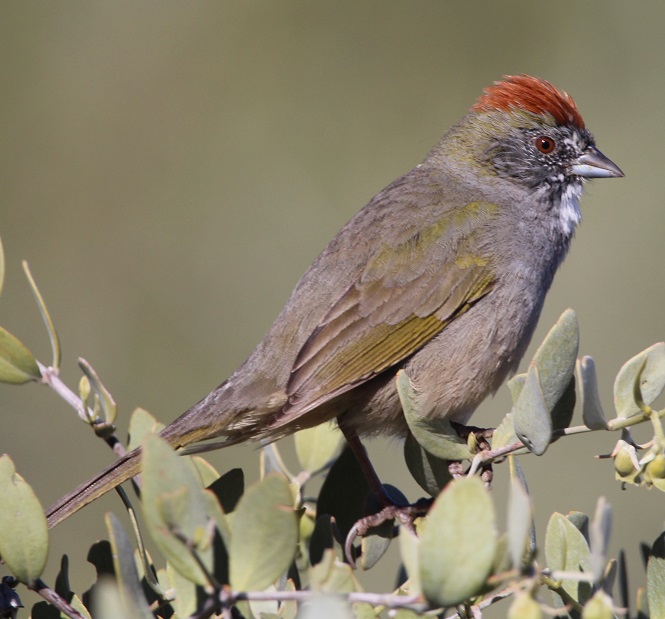
McDowell Mountain Regional Park, situated east of the city of Phoenix, protects just under 22,000 acres (about 34 square miles) of the Sonoran Desert for public use. The park is at the northern reaches of the desert, which itself contains more than 100,000 square miles stretching from southern Arizona down into northwestern Mexico and Baja California. There are plenty of saguaros and other cacti species in the park, along with a tremendous variety of other succulents, shrubs, wildflowers, and grasses. I’m working on a different blog posting that highlights the flowers that were in bloom during our stay in the park – I was really surprised at the variety.This is a female Gila woodpecker (Malanerpes uropygialis), one of the more characteristic birds of the Sonoran desert. Gila (pr. HEE-la) woodpeckers make their nests, containing 3-5 eggs, high up in saguaros, as seen here, and trees. In the United States, these birds are found only the extreme southern areas of the southwest. Male Gila woodpeckers look identical to the female, with the exception of a bright red cap on the top of their head.We’d seen Gambel’s quail (Callipepla gambelii) before, including at a campground in Deming, New Mexico. However, we’d never been close enough to get some decent photos. I took this while standing on the steps of the Goddard and this male quail was standing on our campsite’s concrete picnic table perhaps a dozen feet away. We saw quite a few of these beautiful birds during our stay at the park, and heard a lot more once we learned what their distinctive calls sound like (play the soundfile below, if you dare). Gambel’s quail nests contain between 10-20 eggs. The birds, native to the extreme southwestern United States and introduced in western New Mexico, are usually found on the ground, although we did see a few on top of saguaros (and our picnic table). Gambel’s quail are named after ornithologist and naturalist William Gambel (1823–1849), who at the age of 18 traveled overland to California. He was the first botanist to collect species in Santa Fe, New Mexico, as well as parts of California. A genus of southwestern U.S. lizards is also named in his honor.Nancy took this photo of a black-throated sparrow (Amphispiza bilineata) while perched in her camp chair right next to the Goddard; the sparrow was perched atop a buckhorn cholla that’s about to bloom. Both sexes of this species have the same plumage. These birds, also known as desert sparrows, are remarkably well-adapted to the hot and arid conditions of the Sonoran; during the heat of summer, they derive all the moisture they need from eating insects and seeds. Which is good: at the time of this late-afternoon writing in late July 2023 (we’re currently in southern Idaho), it’s 110 degrees at McDowell Mountain Regional Park. There are 26 species of sparrows in the United States, and most of them are generally brown. The black-throated sparrow is easy to identify, though. (Photo credit: Nancy Jardee)Although I’d read in the park’s literature that this species could be found in the area, it was still a pleasant surprise to see a loggerhead shrike (Lanius ludovicianus) while on a short hike around the campground. I’d never knowingly seen one before, but I’d read quite a lot about them: they feed mostly on insects but will also hunt for mice, lizards, and other small birds when times are tough. Additionally, although this one looks fairly innocuous (that savage hook at the end of his beak notwithstanding), shrikes impale their food on barbed wire or thorns as a means of storage, earning them the nickname “butcher birds.” This curve-billed thrasher (Toxostoma curvirostra) is perched atop a saguaro. I never did quite get used to seeing birds on top of cactus thorns, but I guess they don’t have a problem with it. When they’re not perched on a cactus, curve-billed thrashers spend a lot of time on the ground looking for insects. The look on these thrashers’ faces always reminds me of Sam the Eagle from “The Muppet Show.” I first saw one of these birds at the Tucson Botanical Garden.Since first seeing a northern mockingbird (Mimus polyglottos) near Tulsa, Oklahoma, in 2022, we’ve managed to see plenty of them all over the country. I wonder if it is due to the Baader-Meinhof Phenomenon, like when you learn a new word and then see it a lot in the next few days. Anyway, they’re fun to see and quite enjoyable to listen to – some are capable of learning 200 songs throughout their lives.While I wasn’t particularly surprised to see a northern mockingbird, I was surprised to see this northern cardinal (Cardinalis cardinalis) in the Sonoran Desert. It urns out that the species, while limited mostly to the eastern United States and Mexico, does have an established habitat in southern Arizona. Even though this guy was perhaps 75 yards away, he definitely caught my eye (I also heard his call to let me know in which direction to look). Only a few female bird species sing, and the northern cardinal is one of those species. Interestingly, northern cardinals don’t migrate – they stay in one location all year long.This is a composite image of a female (left) and a male (right) phainopepla (Phainopepla nitens), which are found in the southwestern United States and Mexico. We’ve seen them in Silver City, New Mexico, quite a bit. Absolutely beautiful birds. Their Latin name means “shining robe.” Phainopepla (pr. fay-no-PEP-luh) have evolved to eat mistletoe berries, which are low in nutrients but the birds can eat more than a thousand of them in a day. They can mimic the calls of other birds, including the Gambel’s quail. This is one of the species that has red eyes – there are several theories for that, but one I like is that there is a high concentration of blood vessels in their eyes to help with blood circulation. This pair liked to hang out on the same tree at the same time every morning – very dependable, which is a nice attribute for a bird. Here’s a first-for-me bird: the green-tailed towhee (Pipilo chlorurus). The species, which is only found in the western part of the country, migrates to the northern states for breeding but lives year-round in southern and central Arizona. They are very secretive and can be difficult to see. This guy was hanging out near our picnic table as I got back from a birding walk; I should have just stayed home.A small flock of white-crowned sparrows (Zonotrichia leucophrys) took up residence in a thorny thicket of mesquite along one of the hiking trails near our campground. This species, one of the few sparrows that’s relatively easy to identify, overwinters in the southern United States and is found seasonally all over the country, as well as Canada and Mexico – Alaskan white-crowned sparrows fly 2,600 miles to spend their winters in sunny southern California. One white-crowned sparrow was recorded flying 300 miles – about the distance between Colorado’s northern and southern borders – in a single night.One more sparrow, which I am 98% sure is a Lincoln’s sparrow (Melospiza lincolnii). They are found at least seasonally all over North America and Mexico, with the exception of the southeastern part of the country and extreme northern Canada. This species is not named after the luxury division of Fort Motor Company, as one might think, but rather after Thomas Lincoln, a chum of noted birder John James Audubon. Of the 26 species of sparrows, I can identify only three (house, black-throated, and white-crowned) conclusively. Anyway, almost 12 percent of the North American sparrows are on this blog posting.I’ll close with the cactus wren (Campylorhynchus brunneicapillus), one of the more characteristic birds of the American southwest. In fact, it’s the state bird of Arizona. It’s a noisy little guy, with a call that has been likened to someone trying, and failing, to start a car (reference soundfile below). They are one of the few bird species that roosts in nests throughout the year instead of only during the nesting season.
Nancy and I sort of started birdwatching before we sold our house two years ago, but we’re pretty full-bore into it now. We’re very fortunate to live the way we do, with opportunities to enjoy the tremendous variety of birds in different parts of the country.
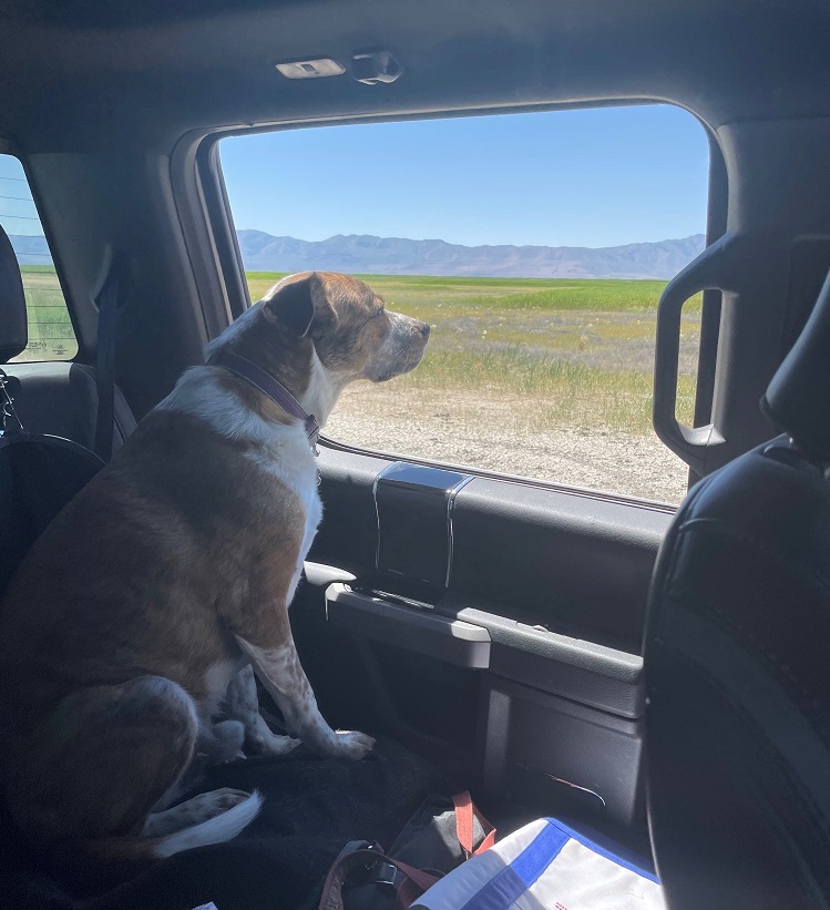
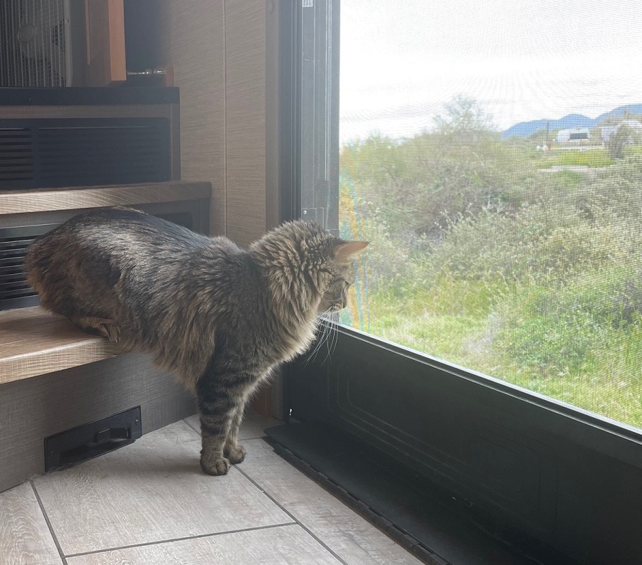
We’re not the most expert birdwatchers on the Goddard, though. Rusty shows us how it’s done:
With the Goddard back in tip-top shape after a visit to an RV service center in Tishomingo, Mississippi, we headed back north to the east side of the Mississippi River and Memphis, Tennessee. Gunther and Rusty had both been boarded in Memphis during the Tishomingo work, and all four of us spent a little over a week camping at T.O. Fuller State Park in the southwestern corner of the city (it’s one of the rare state parks in the country that’s contained entirely within a major city).
The city of Memphis, Tennessee, was founded in 1819 and named after the ancient capital of Egypt, which, like the Tennessee city, is located on a prominent river. Nancy and I like Memphis a lot; we’d traveled to the city for a few days several years prior to our 2022 visit and really enjoyed the city’s cultural history, music, and food (which, in a great place like Memphis, all get kind of wondrously mixed up together).
Memphis is home to the National Civil Rights Museum, which incorporates the Lorraine Motel where Dr. Martin Luther King was assassinated in 1968. Memphis is home to Graceland, where Elvis Presley and his family lived, and where he recorded much of his music. Memphis was home to Sun Records, the recording company founded by Sam Phillips in which Presley, Carl Perkins, Johnny Cash, Jerry Lee Lewis, and so many others got their start. Memphis was home to Stax Records, the studio that released incredible music by Carla Thomas, Booker T. & the M.G.s, Otis Redding, and Isaac Hayes, among many others. Memphis is home to world-renowned barbecue restaurants, and it’s home to a lot of establishments that offer the best of live rhythm & blues and soul music – many of which are on the famous Beale Street, which is itself an open-air celebration of music and food. I should mention here that Nancy and I like Memphis a lot, or maybe I already did.
When planning our trip north in the summer of 2022, then, it was an easy decision to include Memphis in our travels. We decided to park the Goddard at T.O. Fuller State Park – one of the few state parks in the country to be fully inside a major city.
The Goddard’s first destination following warranty repairs (bathroom pocket door back on track, gray water valve operational, and other minor things) in Tishomingo was the heavily forested T.O. Fuller State Park in Memphis, Tennessee, a short distance from the mighty Mississippi River – and directly across the river from our previous campground in West Memphis. It was, by far, the campground with the most overhead tree coverage we’d stayed in to that point, or since. It was so dark inside the Goddard in the daytime that we turned the interior lights on. It was also very, very humid in late June and early July, and the bugs were very, very loud — at times it was nigh impossible to carry on a conversation outside.The 1,138-acre T.O Fuller State Park is very near the east bank of the Mississippi River, and its forest provides habitat for a large variety of birds and animals. A number of hiking trails wind through the forest, which gave Nancy and me, who had both spent most of our lives in Colorado, an opportunity to see a number of plants and trees that were new to us. There were plenty of insects and birds, although, thanks to all of the dense foliage, I didn’t get any good photos of the latter – I did see my first-ever Mississippi kite, though, as it soared over the campground.
The park was a Civilian Conservation Corps project begun in 1938, and was opened as Shelby County Negro State Park – the first state park east of the Mississippi open to African Americans. In 1942 the park was renamed in honor of Dr. Thomas O. Fuller (Oct. 25, 1867 – June 21, 1942), an African-American educator, clergyman, and civic leader.
Dr. T.O. Fuller was the son of a North Carolina carpenter who’d had to purchase his freedom from slavery. Both of Fuller’s parents could read, and they encouraged their children to become educated as well. Fuller earned a master’s degree from Shaw University in Raleigh, North Carolina, and moved to Memphis in the early 20th century. He became an important leader in Memphis religious and political activities, and founded a real estate company that helped many African-American Memphians to purchase their own business properties in the city. Fuller also wrote a number of books that chronicled little-known histories of African Americans. (Photo courtesy of T.O. Fuller State Park.)
Preserving the park’s history as a CCC project, T.O. Fuller State Park today also offers a wealth of recreational activities, including hiking trails, playgrounds, an Olympic-sized swimming pool, and ballfields as well as basketball and tennis courts.
A couple of state park rangers were kind enough to take Nancy and me on a nature hike one early afternoon. We saw quite a few butterflies, including this black swallowtail (Papilionidae polyxenes). In addition to being absolutely lovely to observe, nsects like this species are important pollinators for flowering plants.
Chucalissa
When we made our plans to camp at T.O. Fuller State Park, we had no idea that an important archeological site is within its borders. While digging in the earth for the park’s construction in the 1930s, workers uncovered evidence of a Native American culture that had lived on the bluffs overlooking the Mississippi River. Archeologists called the site Chucalissa, a Choctaw word that means “abandoned house,” for the site. A Memphis Press Scimitar article from 1940 related that Chucalissa “was literally ankle-deep in crumbling bones, bricks, and ancient pottery.”
A research team from the Works Progress Administration began excavating the site and found the remains of a large village with ceremonial and burial mounds. It’s believed that Chucalissa was built beginning around the year 1000, and was occupied until around the time of European exploration of the American continent in the 1500s. The Spanish explorer Hernando de Soto visited other villages along the Mississippi, but it’s thought that Chucalissa had already been abandoned by the time he reached the area around present-day Memphis.
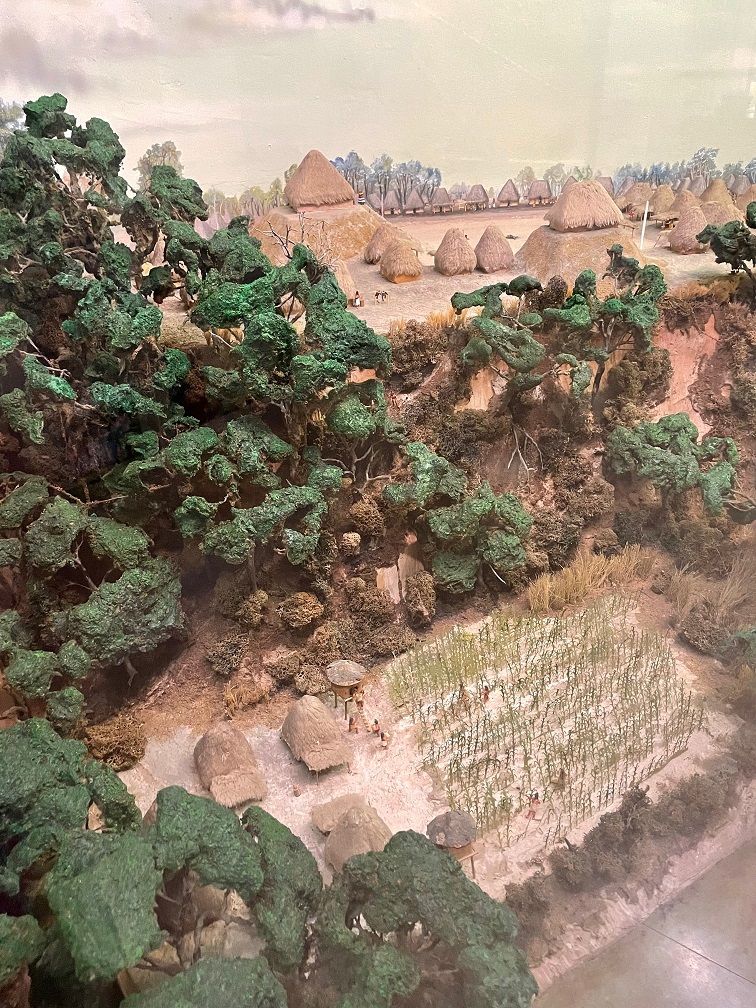
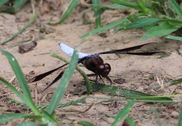
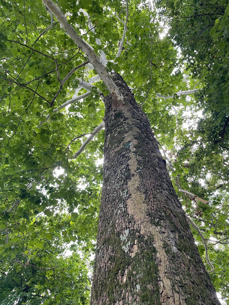
The museum at Chucalissa includes this interesting diorama representing what the scientists believe the village looked like, complete with homes and other buildings, as well as crops growing next to the Mississippi River.This view, looking west toward the Mississippi River on the other side of the trees, is the site of the village’s plaza as it looked on the day Nancy and I visited Chucalissa. The area is defined by three residential ridges. Archeologists believe construction of the large mound on the right side of the photo started around the year 1350, when Chucalissa’s population was at its peak. Researchers rarely find any artifacts in open areas like this. That lack of materials, along with the European explorers’ documentation of how southeast Native American peoples used open spaces in the 1500s, leads to the belief that the plaza was used much as town squares and parks are used today: a shared place for people to gather.We saw a lot of these dragonflies, called common whitetail skimmers (Libellula lydia), while walking around Chucalissa. The species, which measures about 1 3/4 inches long, prefers to perch on the ground. Male common whitetail skimmers, like this one, develop a white powdery substance, called pruinosity, on their abdomens; the females have brown abdomens. The males raise their bright abdomens to warn other males against intruding on their territories. This species is apparently found all across the country, but I’d sure never seen one.We’ve enjoyed seeing new animals in different parts of the country, and we’ve also had the opportunity to see plants that are new to us. This beautiful tree growing near the Chucalissa visitor center is an American sycamore (Platanus occidentalis). They can grow up to 100 feet tall and have the largest trunks of any native American tree, with some specimens having trunk diameters up to 15 feet. To accommodate that growth, the tree often sheds its bark in large pieces. The American sycamore is very common in the eastern part of the country, but the furthest west it grows is the eastern parts of Kansas, Oklahoma, and Texas. American sycamores commonly live for 200 years, and some can grow for more than twice that. The wood is used to make butchers’ blocks, as well as furniture and musical instruments.
It’s interesting to note that when archeologists were excavating the thousand-year-old Chucalissa site, they happened to pull some much more recent artifacts from the ground: farming tools and household goods from the 1800s. They were left by African-Americans homesteaders, who built their lives in the area now known as T.O. Fuller State Park. I like to think that it’s entirely possible that their descendants were aided in bettering their lives by T.O. Fuller himself.
Chucalissa was designated a National Historic Landmark in 1994. The grounds include a very fine museum, named after a prominent archeologist at Chucalissa, C.H. Nash, and a visitor center operated by the University of Memphis.
Seeing Chucalissa was a pleasantly unexpected aspect of our trip to Memphis. Having spent most of our lives in Colorado, Nancy and I are much more familiar with nomadic Native American tribes like the Arapahoe, Cheyenne, and Ute; since seeing more of the southwest, we’ve learned about the Apache, the Hopi, and the Navajo, as well as their ancient forebears. Chucalissa was our first experience of a culture that lived next to a tremendous river – and for nearly twice as long as the United States has been established.
More Memphis
Having visited the National Civil Rights Museum, the Stax Museum of American Soul Music, Graceland, the Memphis Rock ‘N’ Soul Museum on our previous trip to Memphis, Nancy and I concentrated our attention in 2022 on barbecue, Beale Street, and baseball. There’s a particular barbecue restaurant in downtown Memphis that we really like, and we made time to visit it twice while we were there last summer (and I’d go again, twice, right now). Beale Street was a little more muted than when we’d previously been in Memphis, but the pandemic and the fact that it was daylight outside probably had a lot to do with that. Then there’s baseball.
We took the opportunity to take in a Memphis Redbirds game at the ol’ AutoZone Park. The Redbirds are the AAA affiliate of the St. Louis Cardinals, who play their home games at the ol’ Busch Stadium 300 miles north of Memphis (it’s not really the “ol'” Busch Stadium; the current one opened in 2006, replacing the kinda ol’ Busch Stadium which had been built in 1966). AutoZone Park isn’t really ol’ either; it opened in 2000 with a seating capacity of 14,000 that has since been reduced to 10,000. The park offers great views of downtown Memphis buildings, as well as lovely cloud formations over western Tennessee.The Redbirds began play in 1998 as an expansion team of the Pacific Coast League. Memphis has a long history as a home of minor-league baseball teams, most notably the Memphis Chicks from 1901 through 1960. The Chicks started as the Memphis Egyptians, and then from 1909–1911 were the Memphis Turtles before changing their name to the Chickasaws – which was nearly always shortened to Chicks. AutoZone Park is a wonderful venue for baseball, and, because of the lack of outfield seats, it’s sometimes called “one-third of a major league ballpark.” The video scoreboard in this photo is the largest in the minor leagues, and it can be seen from many sites in downtown Memphis. Sadly, the Jacksonville Jumbo Shrimp bested the Redbirds that evening by a score of 5–1, but it was still a fun ballgame to watch.Finally, a bird photo. Memphis is home to the historic Peabody Hotel, which opened in 1925 and is on the National Register of Historic Places. Among the lovely building’s more famous attributes is the daily appearance of the ducks who spend the day cavorting in the lobby fountain. That’s a solid piece of Italian marble in the fountain. The mallard ducks live on the hotel’s roof (in very nice quarters; Nancy and I visited them when we were in Memphis several years ago) and descend to the lobby via the elevator (I’m not kidding) at 11 AM and waddle to the fountain on a red carpet (I’m still not kidding). They return to their penthouse digs, via the red carpet and elevator, every evening at 5 PM. If you’re in Memphis, it’s definitely worth seeing – but plan to arrive early for the arrival or departure, because the lobby gets pretty packed with Peabody Duck enthusiasts. I took this photo when Nancy and I ducked (!) into the Peabody last June while we were downtown to get some more barbecue.
It’s often said of many cities across the country and the world that “they’re nice places to visit, but you wouldn’t want to live there.” Despite having an abundance of things that make Nancy and me happy, like interesting history, lovely live music, and delectable food, we could never live in Memphis – neither of us do well in heat and humidity.
But Memphis remains a great place to visit, and I’m looking forward to the next time we’re there. And now I’m hungry for some barbecue.
We took the Goddard on an east-southeast course in the early summer of 2022 in order to get to our destination of Tishomingo, Mississippi, by late June for some warranty repair work on our home. Our travels took us through the states of Oklahoma and Arkansas, in which neither of us had previously spent much time .
In addition to seeing some new sites of interest, like the Philbrook Museum of Art in Tulsa, we also saw wildlife that was new to us since we were in an unfamiliar part of the country. Depending on where you live, these might be common in your area, but here’s a recap of the birds, new to us, we saw in Oklahoma and Arkansas while on our way to Tishomingo.
Northern mockingbird
We’ve seen many of these birds in the last 12 months, including in the western United States, but the first place we saw a northern mockingbird was about 20 miles west of Tulsa, Oklahoma. This one’s perched on a piece of playground equipment in the campground at which we were staying. Northern mockingbirds, as their Latin name Mimus polyglottos implies, are masters of mimicking the calls of other birds and even other animals and machinery. When we were camped in northern Tennessee later in the summer, a particular mockingbird perched in the campground went through a routine of perhaps 20 different calls every morning. Northern mockingbirds are noted for their intelligence, and are known to be able to recognize different humans. These are the state birds of five states: Arkansas, Florida, Mississippi, Tennessee, and Texas.
I recently finished reading Harper Lee’s novel “To Kill a Mockingbird,” in which a character notes that it’s wrong to kill these birds because “…. they don’t do one thing for us but make music for us to enjoy. They don’t eat up people’s gardens, don’t nest in corncribs, they don’t do one thing but sing their hearts out for us.” They’ve become one of my favorite birds to see and listen to, but they’re (understandably) difficult to identify by their calls alone.
In this same campground, which featured a very nice walking trail along the Arkansas River, we saw two kinds of gulls, great egrets, great blue herons, Baltimore orioles, a northern cardinal, and an indigo bunting. Water makes a big difference when it comes to attracting wildlife.
Northern cardinal
This is not the best photo of this bright species that I’ve taken, but I’m including it because it was the first northern cardinal (Cardinalis cardinalis) I photographed (we’d seen another at the same Tulsa-area campground as above, but I didn’t get a photo). This guy (unlike northern mockingbirds, in which both genders look alike, there’s a clear difference in cardinals) was hanging out in the gardens at the Philbrook Museum of Art in Tulsa. Like the mockingbird, we’ve since seen this species in other places around the country, including in Grand Rapids, Michigan, and (improbably, I thought at the time) atop a saguaro cactus outside of Flagstaff, Arizona. Northern cardinals are very common in the eastern United States as well as a large swath of Texas and parts of Arizona. They do tend to stick out, even in heavy foliage, and they’re always a pleasure to see.
Eastern phoebe
Because we both grew up in Colorado and lived there most of our lives, anytime we see a bird with “eastern” in its name it’s likely new to us. Such is the case with this eastern phoebe (Sayornis phoebe), which is commonly found in the eastern part of the country and especially the south. This little bird, too, was perched on a tree at the Philbrook Museum of Art the evening we were there – it has a bright, very pleasant chirp of a call.
This is one of about 400 species in a group of birds called tyrant flycatchers, the largest group of birds in the world. They’re known for being rather plain-colored like this eastern phoebe [with some notable exceptions, like the scissor-tailed flycatcher (see below) and the vermillion flycatcher, which we saw in early 2023 in Tucson, Arizona]. Flycatchers subsist largely on airborne insects, like their name implies.
Red-shouldered hawk
This is the same bird that I wrote about in the blog posting about our visit to the gardens at the Philbrook Museum of Art, but I wanted to post this alternate photo because this red-shouldered hawk (Buteo lineatus) gave us plenty of opportunity to admire it while it perched on a bridge railing (until some ne’er-do-well kids came tramping along and scared it off, but whatever). Although there’s a small population in coastal California, this is an eastern United States raptor; Tulsa, in eastern Oklahoma, is on the very western edge of their habitat. They’re a little smaller than the red-tailed hawks that are common in the western United States. This species prefers the cover of heavily treed areas (which describes the gardens at Philbrook Museum of Art quite well). Up until around 1900, these birds were among the most numerous raptors in the United States, but deforestation and, until it was banned, DDT contributed to a marked decline in their population.
These last three birds, all seen in the same 25-acre space, give you an idea of the variety of species that can be enjoyed at botanic gardens – they’re great places to visit if you’re into birds.
Scissor-tailed flycatcher
From the Tulsa area we proceeded to western Arkansas, where we camped outside Russellville. There’s a fantastic municipal park on the Arkansas River near Russellville, where we saw several specimens of the spectacular scissor-tailed flycatcher to which I alluded earlier. This is the state bird of Oklahoma, but I guess they’re allowed to be in Arkansas as well (their habitat is the central-southern United States, including all of Kansas, Oklahoma, and Texas).
Want to know why they’re called scissor-tailed flycatchers? Scroll on!That’s why.
(The sign didn’t say “Dang,” by the way – I cropped out the “er.”)
((The “Danger” sign didn’t refer to the scissor-tailed flycatcher, by the way – it had something to do with boating on the river.))
Prairie lizard
TALES OF THE GODDARD LIZARD ALERT: Sharp-eyed readers will have already noticed that this is not a photo of a bird. This is most likely a prairie lizard, or Sceloporus consobrinus. Note, however, that I know next to nothing about lizards, so I could definitely be wrong. Whatever species it is, there were dozens of them at the park crawling around the cement steps leading down to the Arkansas River, which obviously delighted Nancy to no end as we climbed back up. Also, we’ve seen a lot more different lizards in the last year, so prepare yourself for lots of TALES OF THE GODDARD LIZARD ALERTS.
Northern rough-winged swallow
Finally, we made our way to the eastern side of Arkansas, right up next to the mighty Mississippi River, where we camped just a stone’s throw from the Mother of Waters. I’m fairly confident that these are northern rough-winged swallows (Stelgidopteryx serripennis), which were flying acrobatically over the river while hunting for flying insects. We really enjoyed watching them, along with their barn swallow cousins.This is a photo of a barge making its way up the Mississippi, just south of Memphis on the other side of the river from where we were camping. I’m including it because we spent a lot of time just watching these gigantic barges going up and down the river while hauling all kinds of cargo, and there’s also a swallow (dunno what kind) pictured just above the barge, in pursuit of a flying insect.
I kept a list of the different bird species we saw in 2022, and we ended the year with 86 species. As of this writing (late May 2023), we’ve seen nearly 70 species since the beginning of the year. Traveling about the country (although we’ve been only in New Mexico, Arizona, and, briefly, Utah in 2023) helps that number quite a lot, of course, as does keeping an open eye when one is out and about. There’s a lot of diversity out there, and it’s neat to see.
One day – I think it was a Tuesday but I could definitely be wrong – about 35 million years ago, a volcano began erupting in what is now southwestern New Mexico.
Somewhat later, on January 8, 2023, Nancy, Gunther and I visited City of Rocks State Park, located about 20 miles south of the caldera that produced the eruptions. The pumice and other rocks produced by the volcano’s eruptions 35 million years ago form the main feature of the state park, which also has a number of interconnected hiking trails, developed campsites, a botanic garden, and even an astronomical observatory.
We’d planned to visit he park, which is located halfway between Deming and Silver City, New Mexico, just a few miles east of U.S. Route 180, several times in 2021 and 2022 when we were camping in Deming and Silver City. However, the 35 mile-per-hour winds each of those days convinced us to find something else to do. The morning of January 8 was bright and calm, and we made the short trip to the state park. We’re all glad that we did.
You’ll find plenty of prickly pear cactus at City of Rocks State Park in New Mexico, along with a wide variety of other plants. In the background, a vehicle provides a sense of scale for the namesake rocks near the park’s visitor center.
The park, at an elevation of just over 5,200 feet, gets its name from several tall outcroppings of rock that have eroded over the past 35 million years into pinnacles and other formations, separated by lanes that resemble city streets between tall buildings.
Here we see an amateur geologist, with her professional dog, on one of the park’s trails. They appear to be in disagreement about which direction to proceed. The park has about five miles of trails, some of which wind directly through the rock formations. Many of the pinnacles are 40 feet tall.
Paths between the rocks can get pretty tight. During the main phase of the volcano’s eruption, more than 240 cubic miles – about twice the volume of Lake Erie – of pumice and ash were ejected. This eruption also resulted in the “Kneeling Nun” formation east of present-day Silver City, 20 miles to the north. The pointed mountain seen between the two rocks is Cookes Peak (elev. 8,408 feet), a significant landmark in southwestern New Mexico. The mountain is directly north of the city of Deming.
The volcanic eruption that formed the formations of City of Rocks likely lasted several years and was about a thousand times larger than the Mt. St. Helens event in Washington on May 18, 1980. The eruption blanketed this area in a deep layer of hot ash and pumice. As those volcanic materials cooled into a rock called tuff, it shrank somewhat and vertical cracks in the stone were created.
They still haven’t agreed on a direction in which to hike. The park has a huge variety of succulents, like the soaptree yucca at the left of the trail, as well as many grasses common to the southwestern United States.
Over the last several tens of millions of years, the erosive forces of nature – water, wind, and organic growth – broadened the small fissures between the rocks into larger and larger crevices until the natural pathways seen today were created.
Now they’re both headed the same direction. The amateur geologist is standing in a crevice that is a conduit for water flowing through the rock formation. It’s that water, which carries abrasives like sand, that helped carve the rocks into the shapes we see today. Other contributors to the erosion include wind, which can also carry sand, as well as plant (and non-plant) life and the cycle of freezing and thawing water.
Many different groups of native Americans have lived in, or at least passed through, the area now known as City of Rocks. About 12,000 years ago, the last of the Ice Age glaciers were retreating and large mammals like mammoths and mastodons roamed this region. It’s likely that Paleoindians, like Clovis or Folsom peoples, hunted the large animals. Between 8,000 and 1,000 years ago, small bands of the Desert Archaic culture lived in the area and, toward then end of that era, began to build pit houses. Finally, the Mimbres culture occupied the area between the years 200 and 1150 AD. In addition to hunting animals and gathering food from plants, the Mimbres cultivated crops like beans, squash, and maize. They also built one-story above-ground dwellings.
Do you like lichen as much as I’m likin’ this lichen? There are about 20,000 known species of lichen in the world, and at least four of them can be seen in this photograph. Lichen, which is plant-like but not an actual plant, contributes slowly but significantly to the erosion of rocks by chemically degrading the stones’ minerals. The scientists estimate that between 6-8 percent of the earth’s land surface is covered by lichen. Actual plants, like succulents, grasses and shrubs, also contribute to erosion by their seeds finding purchase in small crevices in the rock and then, as the plants mature, the growing roots of the organism can cause further fracturing of the minerals.
Getting up-close and personal with the rocks allows one to see some pretty fascinating natural patterns caused by erosion. I sure hope that whoever dropped those keys comes back by to pick them up! (Just kidding – they’re mine. Still need to go back and pick them up.)
Because the park is 25 miles from the nearest city of any size, it’s a popular site for stargazing at night. This structure is an astronomical observatory located near the main campground in the park. The roof slides back onto the supports in the back to reveal the telescope. It was not in operation during our visit (as you can see, it was daylight), but the park does host regular star parties during which the observatory is open and other amateur astronomers bring their own telescopes to share views of the night skies.
This magnificent succulent specimen, about 20 yards off the trail, is desert spoon (Dasylirion wheeleri). I didn’t want to get off the trail to take a closer picture, so this will have to do. The fronds of desert spoon were used by native Americans to weave baskets and mats, and its inner core can be fermented into an alcoholic drink, similar to tequila, called sotol. It is found in southern New Mexico and Arizona, as well as parts of Texas and Mexico. The plants themselves grow to about 5 feet tall, but the flowering spike can soar 16 feet into the air.
Here’s another interesting succulent found along the trail. This long-spined, purplish prickly pear is called long-spined purplish prickly pear (really) (Opuntia macrocentra). It, too, is found in Arizona, New Mexico and Texas, along with Mexico. Like other prickly pears, the fruit of this cactus is edible and is enjoyed by animals and humans alike.
But it wasn’t simply succulents we saw – we also spied several species of sparrows! Here’s a chipping sparrow (Spizella passerina) perched in some mesquite. We’ve enjoyed seeing plenty of these pretty little birds in southern New Mexico this winter.
While most of the pictures in this posting were taken with the camera on my phone, I used my digital camera to take this photo of Cookes Peak. The tall spindly shrub in the lower left corner is ocotillo (Fouquieria splendens), which can grow to more than 30 feet in height. It is native to the Chihuahuan and Sonoran deserts in the United States and Mexico. Native Americans used different parts of the plant to address a variety of ailments, and ocotillo can also be planted to serve as a natural fence.
A short spur off the main trail took us to the top of a 300-foot hill that provided a tremendous 360-degree view of the area. In this photo, the rock formations of City of Rocks are in the midground (the white streaks above the center of the photograph are campers’ recreational vehicles parked amongst the rocks, and the light brown building to the left of the RVs is the park’s visitor center). The tallest mountains on the left horizon are the Cobre Mountains, 16 miles away, and the Pinos Altos range, 30 miles in the distance, is just to the right of the Cobre Mountains.
This eye-catching grass is cane bluestem (Bothriochloa barbinodis), a valuable forage for ranchers but one of the first grasses to disappear if a pasture is overgrazed. The seed heads catch the sun in such a way as to look absolutely illuminated from within.
When we walk by a creosote bush (lower left), I like to rub my fingers on the leaves – they smell just like the air outside after a rainstorm. Along with seemingly every other plant, Native Americans found many medicinal uses for creosote. In the background is Table Mountain, the tallest point in City of Rocks State Park. The distinct layers of rock seen on the mountain’s slopes are due to different volcanic ashflows more than 30 million years ago..
If you plan to visit City of Rocks State Park, you’ll want to do make plans to do so soon-ish. The erosional forces that created the cracks between the rocks continue to degrade the stones even today (I mean, you saw all the lichen), and in several million years the whole area will just be flat.
Nancy and I definitely enjoyed our time in the park – it was a lovely day, with highs in the low 60s and very calm breezes, and the 4-mile hike gave all of us some great views and good exercise (Monday, January 9, was a day of relaxation and recuperation for Gunther). We plan to take the Goddard to the park in the next few years for some actual camping – it has more than 40 developed sites – and it has some other trails that we haven’t yet enjoyed.