Homolovi State Park, near Winslow, Arizona April 16, 2025
We’re camping for two weeks in Homolovi State Park, just a couple miles east of the town of Winslow, Arizona (pop. 9,005; perhaps you’ve heard of it – one of its street corners is mentioned in the Eagles’ first major hit from 1972, “Take It Easy”). This is our third time staying here in three years – we really enjoy it. After spending five months wintering in Las Vegas, Nevada, and then a couple of campgrounds on Interstate 40 in Arizona, we’re appreciating the quiet environment and dark skies of this state park (not that we didn’t have a good time in Las Vegas; in fact, we’ve reservations to be back there beginning this November).
The main feature of this state park is a cluster of four major ancient Native American villages, several miles apart and all built and occupied around the years 1290-1400. The villages were then abandoned, but it’s generally understood that the people who lived here eventually became what is now the Hopi nation – one of the tribe’s reservations is about 60 miles north of present-day Homolovi State Park. The four villages are designated Homol’ovi I-IV; the name of the state park doesn’t include the apostrophe of the village names. “Homol’ovi,” in Hopi, translates to “place of the little hills,” and the Hopi also refer to the city of Winslow as “Homol’ovi.”
The Hopi call the people who lived here – most likely their ancestors – the Hisatsinom, which means “the people of long ago.” During the period in which the Hisatsinom lived in this region, they built and occupied four or five large villages – some comprising hundreds of rooms – using rocks gathered from the ground.
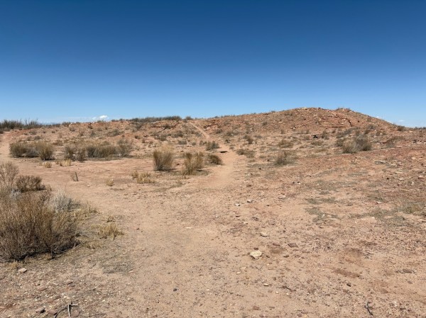
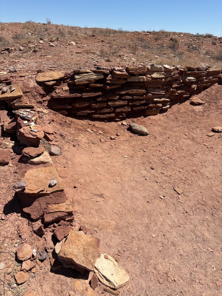
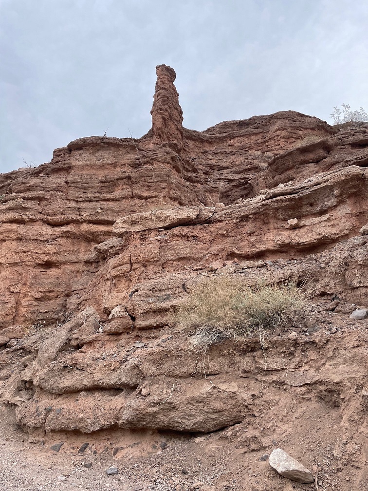
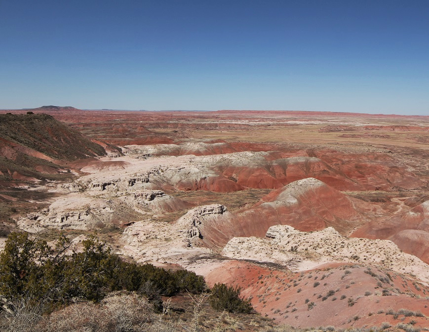
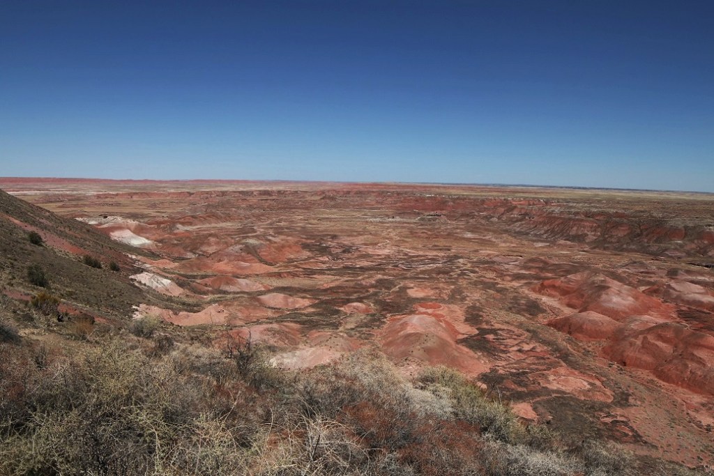
The Little Colorado River, a watercourse that drains the Painted Desert area of northeastern Arizona, flows through Homolovi State Park. I took this photo while Nancy and I were driving to Winslow; the perspective is looking north from a bridge on the former U.S. Route 66 (and now Arizona State Highway 87). The trucks and trailers just on this side of the horizon are on Interstate 40. The Little Colorado River’s headwaters are in the mid-eastern region of Arizona, very near the state’s border with New Mexico. It then flows almost 340 miles in a northwestern direction until it empties into the Colorado River in the Grand Canyon. The river flows from its headwaters all the way to the Grand Canyon only during periods of flash flooding or heavy snowmelt; much of the year it’s a braided and puddled wash. I took this photo the day after the area got some appreciable rain and snow, and the water level rose only marginally. The occasional flash flooding of the Little Colorado River, which swept away crops and structures, is probably why the Homol’ovi sites were abandoned in favor of the area further to the north and which the Hopi call home today.This is the site of a major native American village, known now as Homol’ovi I, that was last occupied about 600 years ago. At its peak, it contained about 1,100 different rooms constructed of rocks. Some of the rooms included three stories. Over the ensuing six centuries, a lot has happened to destroy these unoccupied villages. Dependable northern Arizona winds have covered the village with dirt and sand, but some structures, such as the one on the mound at the right, can still be discerned. Many of the rocks in the structures were taken by members of a nearby Mormon community in the late 1800s for use in their own buildings, and vandals have also destroyed the buildings and looted the pottery.
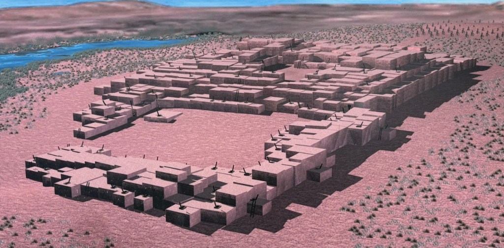
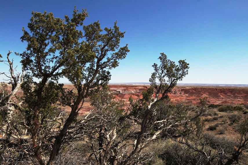
Take a look at the tall plants on the horizon at far left: directly to the right of them, you’ll see some white splotches (not the clouds, which are further to the right; the smaller white splotches of which I write are immediately to the right of the tall plants). Those are the San Francisco Peaks, still snow-covered in mid-April. The town of Flagstaff, Arizona, is at their feet. Those mountains are about 65 miles west of Homolovi State Park.I took a picture of this image, an artist’s depiction of what Homol’ovi I looked like at its peak, at an information kiosk near the site of the former village. That’s the Little Colorado River in top right. The original image gives credit to Douglas Gann of the Center for Desert Archaeology.
From about 1290 to 1360, it’s believed that Homol’ovi I grew from a village of 200 rooms to more than 700. Around the year 1360, the village now known as Homol’ovi II was established about 3 miles, or 5 kilometers, north of Homol’ovi I; that second village quickly became the biggest one in the cluster at 1,200 rooms. Homol’ovi I, however, benefited from the second village’s success, and grew to a maximum of 1,100 rooms.
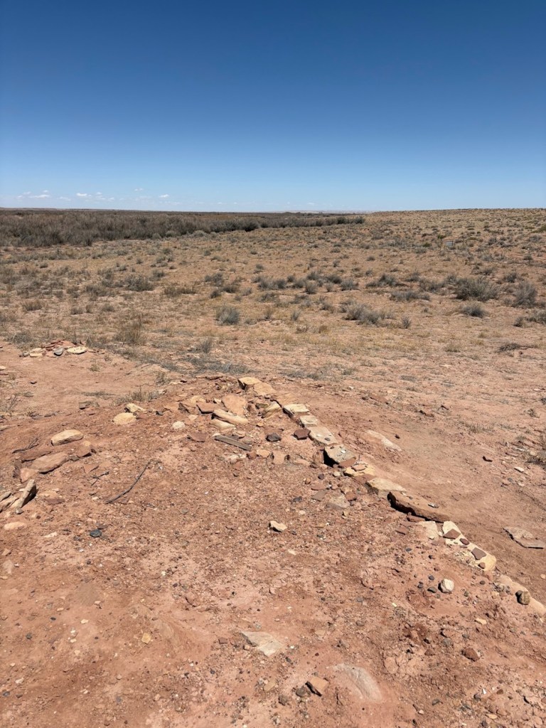
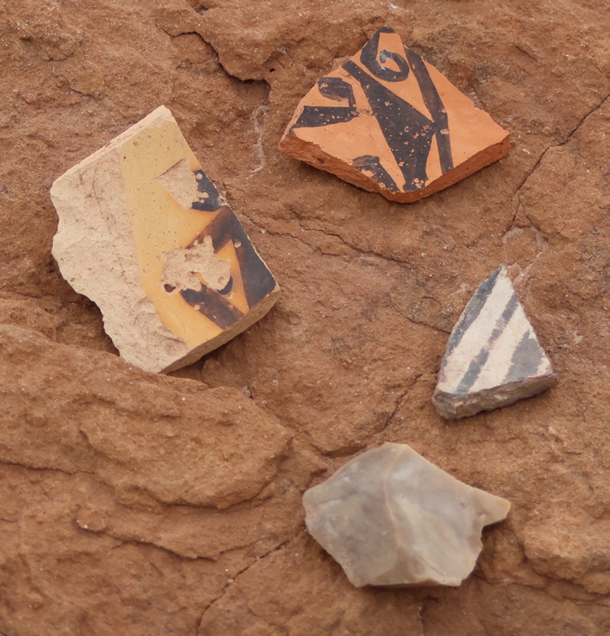
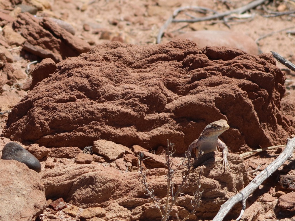
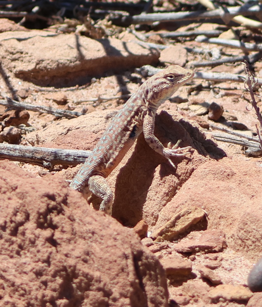
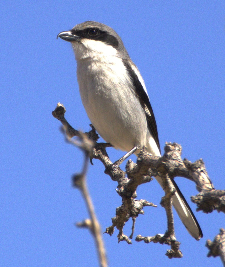
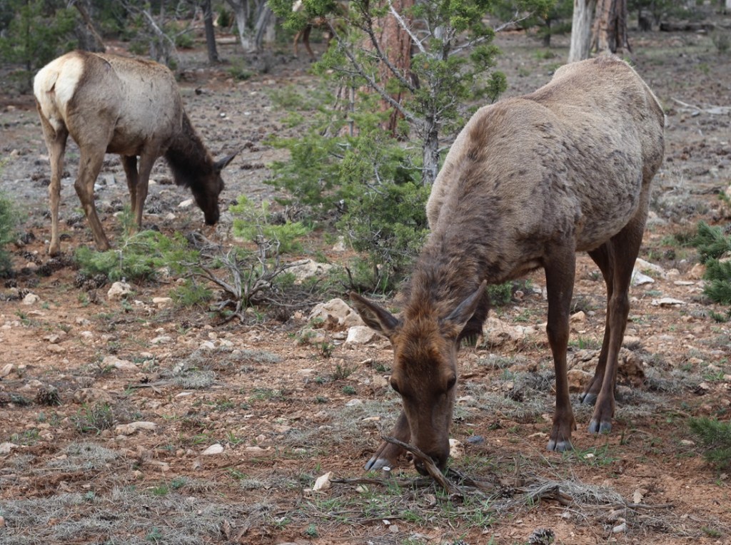
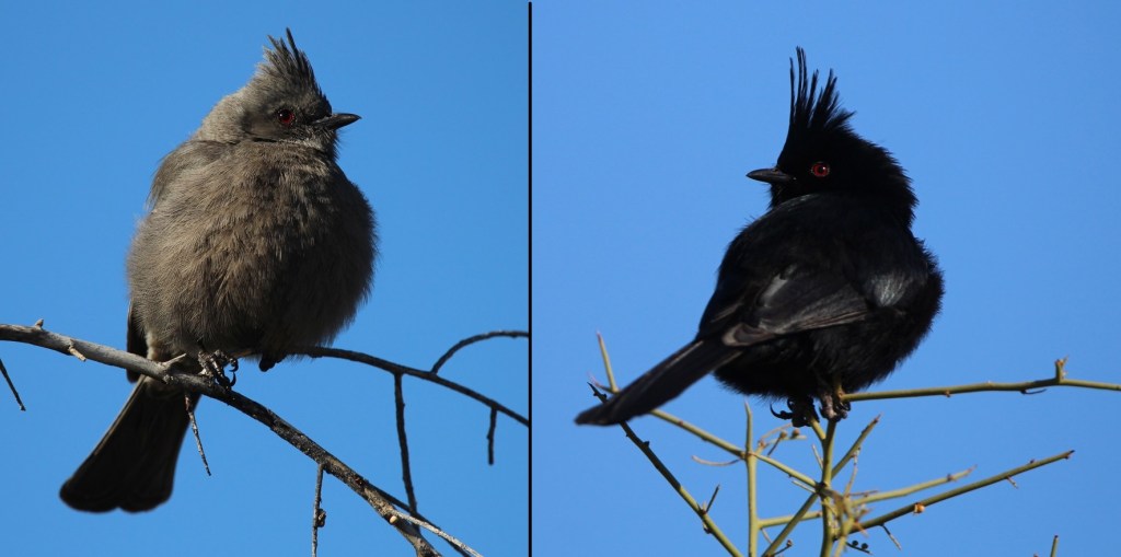
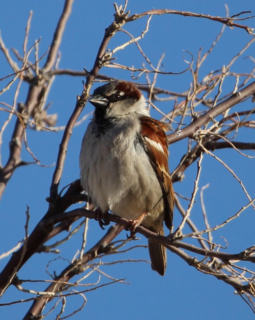
This photograph was taken from the top of the hill shown in the previous photo, still looking to the northwest. The rocks in a line are the former wall of a room. The trees near the horizon are on the east bank of the Little Colorado River; it was that river’s occasional flash flooding that likely led to the abandonment of Homol’ovi I and the other villages 600 years ago.This is a small grouping of pottery shards and what appears to be a hand-shaped rock, taken from the ground at Homol’ovi I and placed on a larger rock. The pieces of pottery are roughly the size of an American half-dollar. There are thousands of shards like these at the site, and most of them are on larger rocks like this. Archeologists and conservationists prefer that people don’t do this; instead, simply leave the shards on the ground.This is the largest exposed wall still standing at Homol’ovi I, and it’s been almost entirely rebuilt by archeologists. Note the small collections of pottery shards on some of the rocks at left: don’t do that.THIS IS A TALES OF THE GODDARD LIZARD ALERT. This little guy (and he is a guy, and I’ll tell you why I know shortly) caught my eye as he scampered across the rocks and sand of Homol’ovi I. He is a side-blotched lizard, a genus (Uta) of which there are now seven species, and he and I were to have kind of a neat interaction. This photo of my new reptile pal shows why the genus is called side-blotched lizard – observe the dark mark (or, in scientific terminology, “blotch”) on its side just behind its front leg. The turquoise-blue dots on the back are also a defining characteristic of the genus. These lizards grow to a length of about six inches, including the tail. Their diet includes insects, spiders, and other arthropods such as the occasional scorpion. They are themselves predated upon by larger lizards and roadrunners.In an attempt to give the reptile some space, I continued walking down the path through Homol’ovi I – but the beast pursued me. Observe the very pretty light-blue dots on its back. I was about six feet from the lizard when I took this photo (using a 400mm telephoto lens).Here’s a cropped version of the previous photo. Behold those beautiful blue dots as well as some detail of its fearsome front claws. After I took the photo, the lizard continued to approach me: in fact, it got to about six inches from my left foot – and then it scampered away. Turns out, that’s a common behavioral trait of male side-blotched lizards. The scientists don’t know if the behavior is intended to scare away possible intruders from its mate, or to defend its territory. At any rate, I got the hint and moved along (even though my course on the path took me in the same general direction of the lizard, who at that point was many yards away). I later described my interaction with the side-blotched lizard to Nancy, who did not at all appreciate when I poked her under her armpit to show her where the blotch on the lizard’s side was. We also shared the same belief that she would have absolutely and completely freaked out if the lizard had gotten to within six inches of her left foot.More wildlife: I always like to include some bird photos in these postings, so here are a couple of images I took in our campground at Homolovi State Park. This is a black-throated sparrow (Amphispiza bilineata), a species found in the southwestern United States and much of Mexico. They are absolutely beautiful little birds. I’ve seen them only here at Homolovi State Park and at Tuzigoot National Monument, further west in Arizona.This is a loggerhead shrike (Lanius ludovicianus), on a tree just a few feet from the Goddard’s campsite. I remember reading about shrikes when I was young, but I didn’t see one in the wild until a couple of years ago at McDowell Mountain Regional Park east of Phoenix, Arizona. I also saw some over this past winter at Clark County Wetlands Park, very close to the campground where we spent the winter near Las Vegas. Loggerhead shrikes are found nearly all over the United States.
We’re planning to join a ranger-led tour of Homol’ovi II, which has been partially excavated and reconstructed, on Saturday, April 26. I’ll write and post photographs from that experience afterwards. We were on the same tour a couple of years ago, but, because of our travels and opportunities to see ancient Native American sites in the southwestern United States since then, we have a better perspective of what we’ll see.
As we were walking away from my first viewing of the Grand Canyon, I turned to Nancy (who’d been to the national park on a hiking trip with friends some years earlier) and said, “I wasn’t prepared for that.”
And that was an understatement among understatements. I’d seen countless photos, as well as tons of video footage and movie clips, of this geologic wonder, and I was woefully unprepared for just how stunning the views are when one is actually standing on the rim of the Grand Canyon. More than a year later, while editing the photos for this blog posting, I am shaking my head at the images and believe me when I tell you: my photos don’t do the Grand Canyon justice and neither do anyone else’s.
“In the Grand Canyon there are thousands of gorges like that below Niagara Falls, and there are a thousand Yosemites. Yet all these canyons combine to form one grand canyon, the most sublime spectacle on the earth.”
– John Wesley Powell, 1895
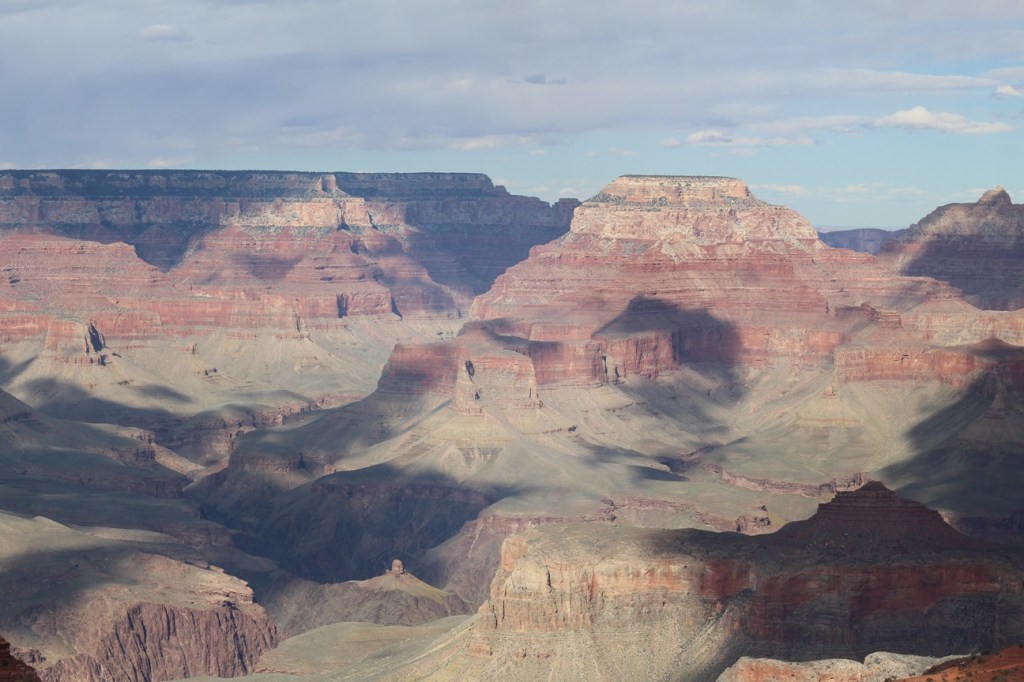
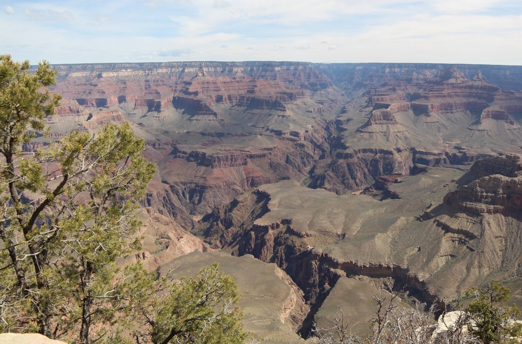
This is the first photo I took from the rim of the Grand Canyon. The views are so expansive, both in distance and depth, that the light from the sun and shadows from cloud cover change what you see from minute to minute. The average width of the canyon from the South Rim to the North Rim is 10 miles. The different colors in the rocks are due to the presence of varying minerals, such as iron oxide, in each layer.
Grand Canyon National Park: By The Numbers
Date established
January 11, 1908 (national monument); February 26, 1919 (national park)
Total area
1,902 square miles
Total visitors
4.73 million in 2023
Elevation
South Rim: 7,129 feet (elevation of North Rim is 8,145 feet); elevation of Colorado River is 2,400 feet
The Grand Canyon’s dimensions are so big that the numbers are related in miles, not feet. Consider that the state of Colorado measures 280 miles from its northern border with Wyoming to its southern border with New Mexico. The Grand Canyon, at 277 miles long, is only three miles shorter than that distance. The width of the canyon is an average of 10 miles. It’s nearly one mile – an average of 5,000 feet – from the rim of the canyon to the Colorado River below.
Here’s something about the Grand Canyon that I find really hard to fathom: the scientists believe that the canyon is only 6 million years old. In geologic time, that is less than the beginning of an eyeblink. Prior to the 1966 completion of Glen Canyon Dam, upriver from the Grand Canyon, during spring and summer runoff hundreds of thousands of tons of sediment would be carried by the Colorado River – each day. That water, pushing and pulling and tossing sand, gravel, rocks, and boulders through the canyon, gouged what is now a mile-deep course through what is now northern Arizona. The erosional forces also included precipitation and freezing and thawing of water along the canyon’s walls.
Early European-American residents of the American Southwest recognized that the Colorado River had to be tamed in order to prevent it from wiping away those resident’s properties during spring and summer floods. Creation of the national monument in 1908 and eventual designation of Grand Canyon National Park in 1919 assured that no manmade water diversion projects would be constructed within the boundaries of the park.
This is the second image I took of the Grand Canyon. The multicolored and clearly delineated rock layers, including sandstone, limestone, shale, schist, and others, range in age from 2 billion years old at the bottom of the canyon to 250 million years old at the top, nearly one mile above the Colorado River.
Beginning from Lees Ferry on the east to Grand Wash Cliffs on the west, the Grand Canyon measures 277 miles in length (at 280 miles, the state of Colorado is 3 miles longer from its northern to southern borders) . Two great manmade structures bounding the Grand Canyon, Glen Canyon Dam and Hoover Dam, create two immense reservoirs, Lake Powell and Lake Mead respectively, to manage the Colorado River’s water flow.
As it flows through the Grand Canyon, the Colorado River has an average depth of 35 feet and a width that varies from 76 feet to 300 feet. During normal operations of Glen Canyon Dam (and when the American Southwest isn’t enduring its ongoing decades-long drought), almost 130,000 gallons of water moves through the canyon’s inner gorge every second – enough to fill an Olympic-sized swimming pool in 5 seconds. The volume of water released through the canyon is often dependent on municipal electricity demands from cities as far away as Los Angeles. The Colorado River used to flow 1,450 miles from La Poudre Pass in Colorado’s Rocky Mountain National Park all the way to the Gulf of California; municipal and agricultural demands on the river in the southwestern United States cause the river to gradually dry out shortly after crossing into Mexico.
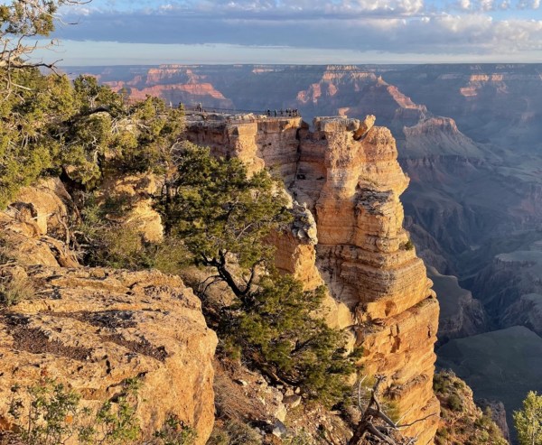
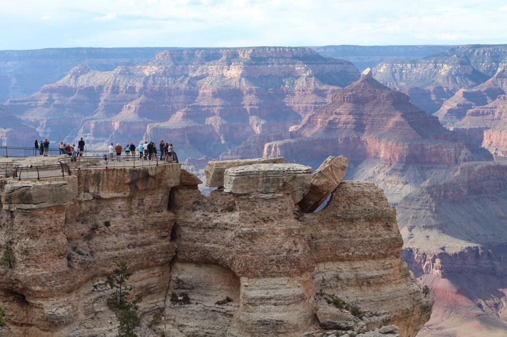
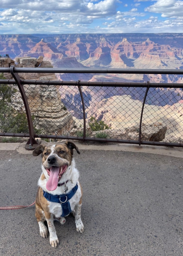
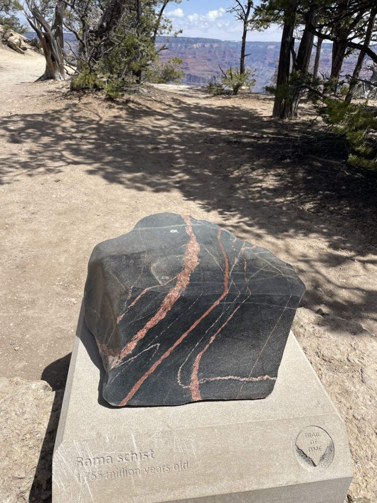
We’ve all seen plenty of canyons across the country and around the world, most of which are easily identifiable by the watercourse that originally carved them. But, in many places, the Colorado River isn’t visible from the rim of the Grand Canyon – there are too many smaller canyons, many of which would be significant geologic features on their own anywhere else – that block the view. The Grand Canyon is a supercanyon of canyons. (This is the third photo I took of the Grand Canyon, by the way. I took hundreds. I won’t post them all, I promise.)Here, then, is the fifth photo I took of the Grand Canyon. We weren’t the only visitors to the national park that day. This is a group of people at Mather Point, one of the larger overlooks that extends into the canyon. Clear days at Mather Point provide views of up to 30 miles to the east and 60 miles to the west. The overlook, along with a campground in the national park, is named after Stephen Tying Mather (1867-1930), the first director of the National Park Service.Here we see a visitor (it’s Gunther) to Grand Canyon who, like me, is experiencing his first few hours at the national park. Gunther was able to join us on our first visit to the canyon’s South Rim, which has a mostly paved walking trail extending 13 miles. That’s Mather Point in the left mid-background.At an elevation of 7,000 feet above sea level, the South Rim of the canyon features an extensive ponderosa pine forest. The campground in which we parked the Goddard was a very pleasant one-mile walk through this forest, which also includes Gambel oak, mountain mahogany, and elderberry shrubs, to the canyon. And there were elk in the forest. Lots and lots of elk. On a couple of occasions, we saw elk grazing perhaps 10 feet from our fifth-wheel home. Some local residents we met on the trail said the elk, just prior to big-game hunting season in the fall, have an uncanny ability to move from the Kaibab National Forest into the protected lands of Grand Canyon National Park.I took this photo with a wide-angle lens in a vain attempt to capture some of the vistas from the rim of the Grand Canyon. This is looking west-northwest further west from the Visitor Center, down the park’s Rim Trail. In the direct middle of the photograph is a light-brown spot, at the bottom of the canyon. Yep, that’s the Colorado River, a mile below the rim and probably two miles north of this viewpoint. The temperatures at the bottom of the canyon are typically 30 degrees higher than at the rim.The Rim Trail, which follows 13 miles of the South Rim, has a pretty nifty display called the Trail of Time in which millions (and billions) of years of the earth’s existence are represented by steps on the 1.5-mile section of trail. The intent is to illustrate the incredible amounts of time that are represented by the different types of rocks found in the canyon, with more than a dozen clearly defined layers from top to bottom of the canyon. The further along the Trail of Time you walk, the (figuratively) further back in time you go. Along the way are representative rocks from the different depths of the Grand Canyon. Pictured here is a pretty sample called Rama Schist, which is from a part of the canyon that’s just under 1.8 million years old. Geologists believe that the Colorado River began forming the Grand Canyon by carving through the 250-million-year-old Kaibab Plateau layer about 6 million years ago, meaning the canyon is only 2.4 percent as old as even its uppermost (and youngest) rock layer. Since then, it has only carved deeper and the canyon is now a mile deep – although its erosional power has been greatly reduced by manmade dams upriver.Here’s another view. looking west-northwest again, a little further down the Rim Trail. The mighty Colorado, still a light brown smudge, is in the lower right corner of this image. I was not expecting so much tree growth at the top of the canyon, but the Rim Trail is heavily shaded for long stretches.
The South Rim of the Grand Canyon receives about 15 inches of precipitation annually, while the North Rim receives just over two feet. The winter of 2022-2023 was an exception, at least for the North Rim. While we were at the South Rim in late April 2023, there was still snow visible on some north-facing walls of the canyon. Because of huge amounts of snowfall during the winter of 2022-2023, the roads leading to the North Rim of the Grand Canyon wouldn’t open until early June.
One more wide-angle view, which depicts some the thousands of smaller canyons in the park that lead into the Grand Canyon. The Colorado River is visible in this image, just to the lower-left of center and to the right of the tree limbs.
The Grand Canyon was designated a UNESCO World Heritage Site in 1979. Those sites are deemed to contain “cultural and natural heritage around the world to be considered of outstanding value to humanity.” These sites must be unique, geographically and historically identifiable, have a special cultural or physical significance, and be under a system of legal protection. UNESCO World Heritage Sites can be ancient ruins, deserts, islands, mountains, wilderness areas, and other natural or manmade features. As of July 2024, UNESCO had recognized just over 1,200 World Heritage Sites; Mesa Verde in Colorado and Yellowstone in Wyoming are examples of other U.S. national parks that are also UNESCO World Heritage Sites.
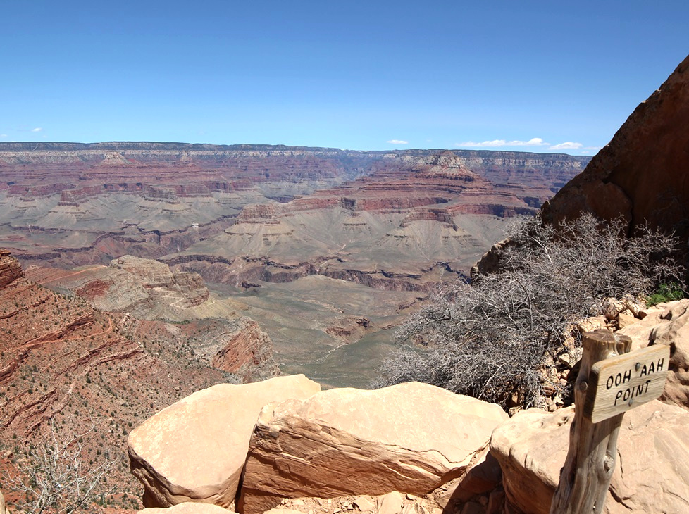
Leaving Gunther at home for a few hours one day, Nancy and I went on a great hike down into the canyon on the South Kaibab Trail to see this view looking across the eastern Grand Canyon. The sign at lower right indicates viewers’ usual reactions.Here we see an intrepid hiker (it’s Nancy) making her way from Ooh Aah Point, beginning the return to the canyon rim on the South Kaibab Trail. This view is looking north.This view, from a point about as far west as we walked on the Rim Trail, is looking east toward the Visitor Center. The zig-zagging line at the bottom of the image is the Bright Angel trail, which Nancy hiked with friends some years ago. It’s an aggressive hike.One more view of the Mather Point overlook: on the morning of April 25, 2023, Nancy and Gunther and I got up early to watch the sunrise at Grand Canyon National Park. The low angle of the dawn’s rays gave the canyon’s features added depth and still more colors that we hadn’t yet seen. This is nearly the same perspective as the fourth photograph in this blog, but compare the coloration and shadows between the two images. The sun has risen on this landscape 2.2 billion times since the Colorado River began carving the canyon. This was just one of those times, but it was still spectacular.
If you’ve been to Grand Canyon National Park, you know this: it’s a must-see park; if you haven’t been, know this: you must see it. The views are simply unmatched, at least in my experience, and the hiking opportunities range from level and paved trails to “park rangers may not be able to come rescue you,” with everything in between.
For such a recent addition to the Earth’s surface (seriously, 6 million years of erosion on this planet is absolutely nothing in the grand scheme of things), the Grand Canyon is an amazing spectacle that really has to be seen in person to get a full appreciation of its beauty. As much as I’ve gone on and on about it, you won’t be prepared when you see it, either.
Grand Staircase-Escalante National Monument is big – really big. In fact, although it’s the seventh-largest U.S. national monument by size, it’s the biggest in the country that’s not either entirely in or adjacent to an ocean. At 1.87 million acres (just over 2,900 square miles), the national monument is nearly twice as big as the entire state of Rhode Island, and just a tad bigger than the state of Delaware.
This area in southern Utah is vast, and it is remote: it was the last part of the contiguous United States to be mapped by the federal government. Grand Staircase-Escalante National Monument was authorized by President Bill Clinton in 1996. This is also one of the more contentious federal properties; President Donald Trump effectively halved its acreage in 2017, and then President Joe Biden restored it to its current size in 2021. It is the first national monument to be administered solely by the Bureau of Land Management (BLM).
(A brief sidenote: the U.S. government’s holding of lands, especially at the levels of national monuments and especially those in the western United States, is criticized by some groups and lauded by others. Much of these lands frankly isn’t good for anything except looking beautiful and supporting native plants and animals – which, in the eyes of some, is more than enough reason to provide federal protection. Other groups are interested not so much in the lands themselves, but what’s under the lands’ surfaces: minerals, petroleum, and other extractive materials. Everyone from kayakers to native Americans to miners to anglers to ranchers to tourists wanting a scenic drive has an opinion on what should and shouldn’t happen on these lands. U.S. presidents are able to establish and change landholdings under national monument status as they see fit; acts of Congress are needed to establish or change national parks. I’m someone who enjoys nature quite a lot, but I also realize that I use minerals and petroleum extracted from the earth nearly every minute of every day – in the laptop I’m typing on, in the fifth-wheel trailer in which we live, and in the iPhone and digital camera with which the following photos were taken. You most likely are equally dependent on those extractive resources. As with most issues in life, it takes a balance. Grand Staircase-Escalante National Monument is especially contentious because county and state governments also want to maintain at least some control over what can and can’t happen within its borders.)
(That sidenote was less brief than I’d expected.)
Anywho, Grand Staircase-Escalante National Monument takes up a sizable chunk of southeastern Utah. It protects three major areas: the Grand Staircase, the Kaiparowits Plateau, and the Canyons of the Escalante. The Grand Staircase is so named because of its stepped appearance if viewed from the side: from west to east, the landscape drops in elevation in enormous eroded and even layers. The steps drop, west to east, in cliffs measured in hundreds of feet. The area represents 400 million years of geologic development.
The views at Grand Staircase-Escalante National Monument are simply spectacular. The monument is bordered by Bryce Canyon National Park on its western edge and by Glen Canyon National Recreation Atea on its eastern side.
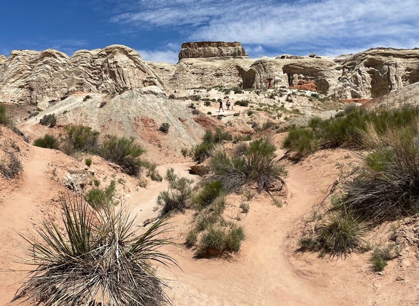
One fun thing to do in these federally protected lands is to go on a hike, and that’s what Nancy and I did in late May of 2023. The Toadstool Trail leads to some wonderful rock formations and other features of this otherworldly environment. In its easy out-and-back 1.5 miles, one can see rocks eroded from water, rain, and other elements to create some pretty stunning scenery. We happened to visit the area when a number of flowering desert plants were in bloom, which was great to see.
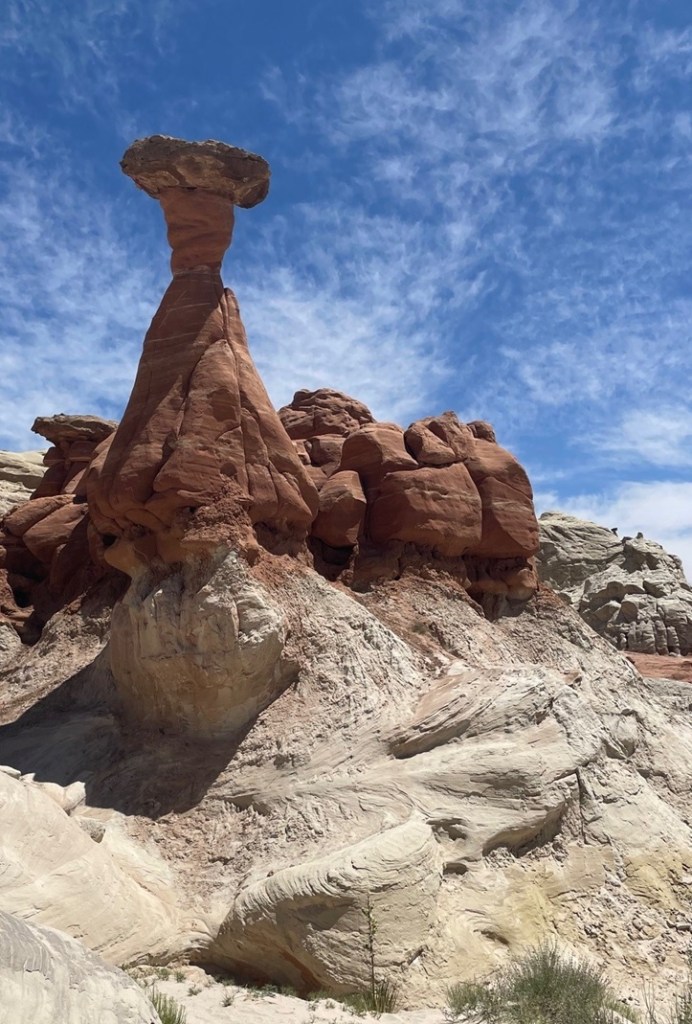
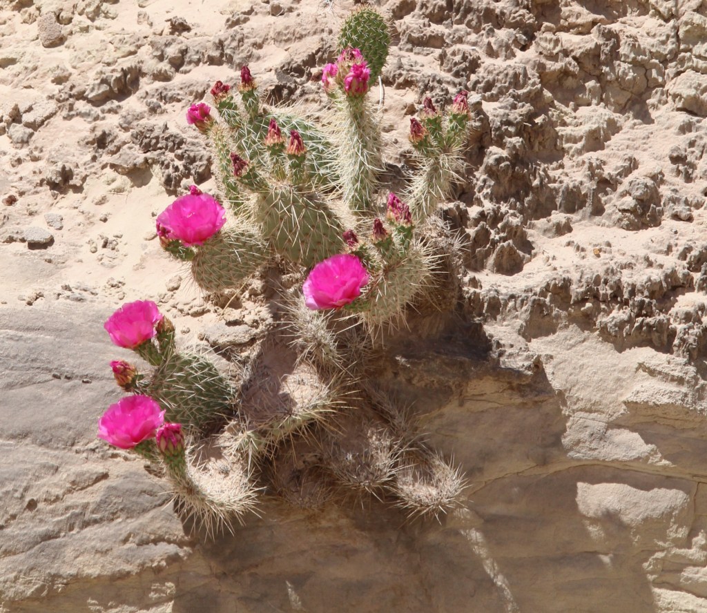
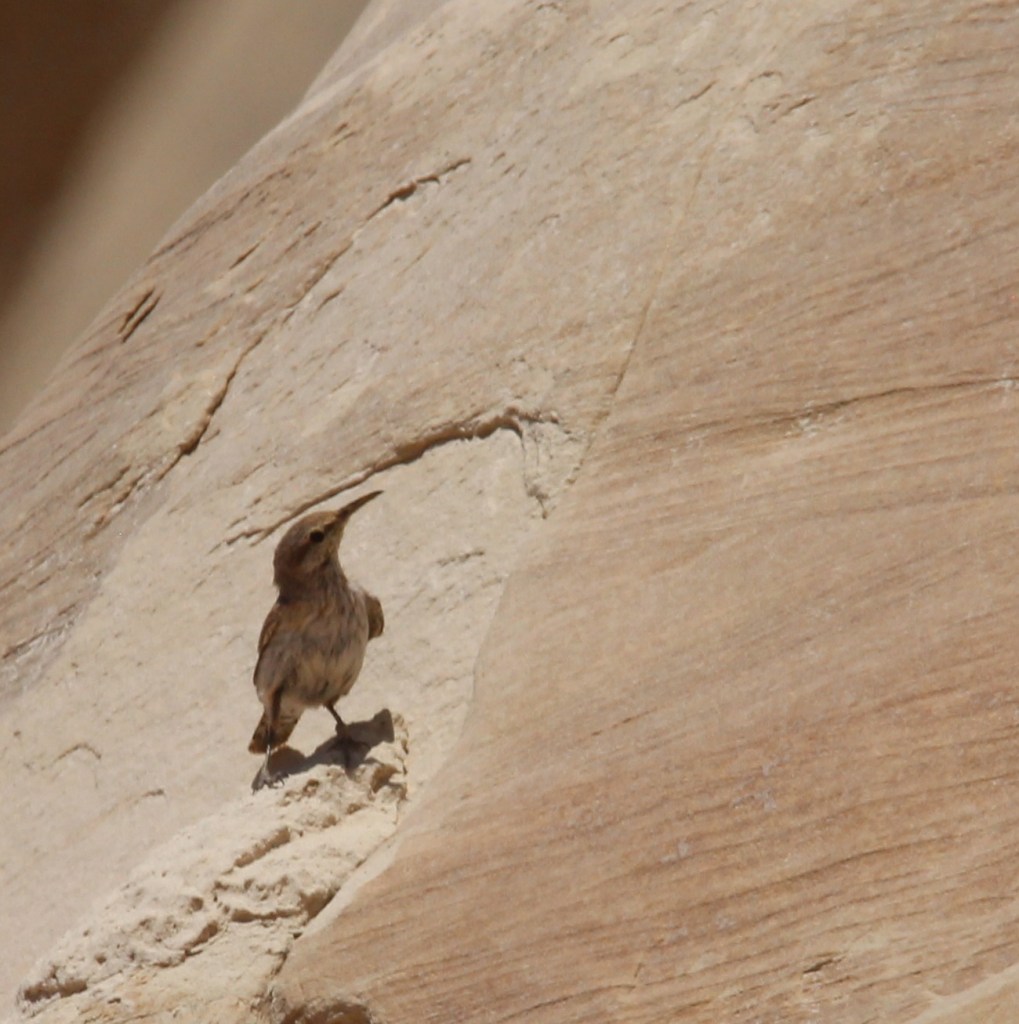
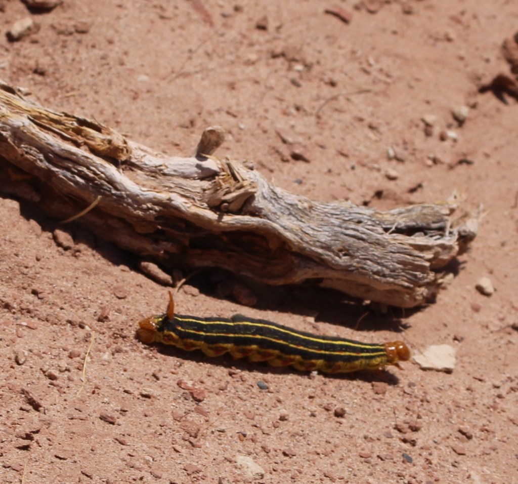
We visited the national monument on a beautiful day in late spring, when there was little chance of rain, but there was plenty of evidence that the area receives considerable amounts of moisture at times. This ravine was cut by a seasonal watercourse; the hiking trail is at the far right of the photo. Note the coloration of the different layers of rocks in the cliffside.This pretty flower is a sego lily (Calochortus nuttallii), which happens to be the state flower of Utah. We saw quite a few of these blossoms, which can measure up to three inches across, on the hike. “Sego” is believed to derive from the Shoshone name of the plant.There’s a lot going on in that cliff, not the least of which is the wavy nature of the rock layers on the left. I took this photo from a U-bend in the trail (it continues on the left and right of the photo) and you can see some hikers near the center of the photo.This is a TALES OF THE GODDARD LIZARD ALERT. I’m not an expert on reptile identification (I’m not really an expert on anything, come to think of it), but I believe this to be a common side-blotched lizard (Uta stansburiana). They grow to a length of about 2.5 inches not including the tail, which is often longer than the body. Judging from the Wikipedia page on these little rascals, a lot of the scientists have spent a lot of time observing this species. This is a lizard that can safely lose its tail to escape a predator, but that comes at a terrible cost: loss of social status within a group of other common side-blotched lizards. We saw several of these lizards and all still had their tails, so we were among the elite. This isn’t the first lizard species to live in the area; researchers have found fossils of several different dinosaurs within the borders of the monument.This is the largest rock formation from which the Toadstools Trail gets its name, and it’s plenty spectacular. If I had to guess, I’d say the column is about 25 feet tall. Formations like this occur when softer rock under harder, denser rock is eroded away. These are basically small buttes, with more material underneath the surface caprock taken away by water, wind, and other erosional forces, to form a toadstool formation.I thought this rock wall was interesting because it shows not just the colors of the different rock layers, but the different density of the layers as well: note the edge-on layers of rocks upon which less-dense layers, which are disintegrating faster, were deposited over millions of years.The bright blossoms of this plains pricklypear (Opuntia polyacantha) were hard to miss in an otherwise tan-colored environment. The flowers of this species of cactus can be yellow, red, or magenta, as on this specimen. These plants provide a source of food for quite a few animals, like prairie dogs and pronghorns, and many people enjoy eating the fruit (if animals haven’t gotten to them first) once the blossoms are spent.Although the larger toadstools are very impressive, the rock formation – a column supporting a wider, flat cap of harder stone – is fairly common in the area. They make for some interesting viewing opportunities.This is Coulter’s lupine (Lupinus sparsiflorus), also known as Mohave lupine or desert lupine. The plants grow to a maximum height of about 16 inches. We’ve seen this pretty flower elsewhere in the deserts of the western United States; it, along with the other plants that happen to be flowering at the time, provides a nice pop of color.This blurry photo is unfortunately the best of three I took before this rock wren (Salpinctes obsoletus) took off to raise havoc somewhere else. This species, fairly common in the western part of the country, is adapted to cling to rock faces while hunting for insects and spiders.Shortly after we’d started this hike, another hiker suggested that we continue walking past the main toadstool formations for some really nice views, more toadstools, and balanced rocks. We took his advice, and we’re glad we did. I’m going to guess that it’s six or eight miles to the horizon. Here we see a lone hiker (it’s Nancy) looking west; Kanab, Utah, is about 40 miles thataway.In this very arid environment, anything that moves and (especially) is not some shade of brown quickly catches your eye. This caterpillar is the larval stage of a really nifty moth called the white-lined sphinx, or hummingbird moth (Hyles lineata). The adult version of this species can be easily mistaken for a hummingbird as it hovers over blossoming flowers. The species is very common from central America up into Canada, including most of the United States. The spike at the back end of the caterpillar isn’t a stinger but it does give this larval form another name: hornworm. They aren’t harmful to humans but given a big enough population, these voracious eaters can destroy cultivated crops and flowers. Conversely, the adult moth form is beneficial for plants because of its ability to pollinate while feeding.That hiker who suggested that we continue our walk past the main formations was absolutely right, and we were able to see some really pretty toadstools and long vistasThe yellow blossom on the left is red dome blanketflower (Gaillardia pinnatifida), while the white blossom belongs to a flowering plant called birdcage evening primrose (Oenothera deltoides). Because they don’t require a lot of care, blanketflower species are very popular in home flower gardens – I planted some of them in our xeriscaped lawn in Denver.The cliffs, toadstools, balanced rocks, and other rock formations in the national monument were created by erosion and plenty of time. I’m including this photo to show how even tiny trickles of water coming down a rock face can create really interesting designs.Native American cultures arrived in what is now the national monument around 1,500 years ago. There are hundreds of petroglyphs that document those peoples’ existence in the area, and the rock in the foreground looks to have two of them. This was at the mouth of a very short canyon eroded into a cliff wall.Here’s a closeup of one of the petroglyphs on the rock pictured above. I have no reason to think it’s not genuine, but I sure can’t think of any horned quadrupeds that also have long tails. Maybe it’s a depiction of something else entirely.On the way back to the trailbead, another hiker with a digital camera and long lens was as excited as me to see this bird about 50 yards away from us. We couldn’t identify the species at that distance, so I was certainly looking forward to getting back to the Goddard and looking at the picture on a larger screen. “What kind of exotic birds could possibly live in this remarkable desert environment?” thought I, taking picture after picture of a bird I couldn’t make out through the camera lens. Turns out, it’s a house finch (Haemorhous mexicanus) which is common all over the country so it’s not nearly as exciting as I first thought. However, I’ve gone some days without seeing any birds at all and those days aren’t any fun so I’ve learned to appreciate all the birds I see, no matter how common they are.This photo was not taken on the Toadstools Trail, but I wanted to include it in this posting about Grand Staircase-Escalante National Monument. It shows a spectacular bluff above a former townsite called Paria, which was a Mormon settlement from 1870 to 1929. The town was abandoned because it kept getting inundated by floodwaters. It must have been a tremendously hard way of life, separated from other communities by dozens of miles, but at least the view was pretty good.
Lake Mead National Recreation Area Near Las Vegas, Nevada – January 6, 2024
Impounded behind the concrete and steel of the magnificent Hoover Dam, Lake Mead in southeastern Nevada and southwestern Arizona is, by volume (and when full), the largest inland reservoir of water in the United States. There are a couple of U.S. reservoirs that have a larger surface area, but they don’t have the depth of Lake Mead (when full). The reservoir, made by the result of damming the Colorado River, is the primary feature of Lake Mead National Recreation Area – the nation’s first NRA as well as its largest at 1.5 million acres, or just over 2,400 square miles. For perspective, Lake Mead NRA is a couple hundred square miles larger than Kit Carson County in far eastern Colorado.
When full, Lake Mead has a surface area of 247 square miles, a surface elevation of 1,229 feet above sea level, and a maximum depth of 532 feet. When it’s full.
Lake Mead is, at the moment, not full. Not even close, really. In fact, it’s a couple hundred feet below its capacity, and it hasn’t been this empty since it was first filled after the construction of the Hoover Dam in 1937. A multi-decade-long drought in the southwestern United States, as well as unprecedented demand for agricultural and municipal water in the multi-state region served by the reservoir, have led to a stunning drop in the water level of Lake Mead. The reservoir’s capacity is so large that one inch of water in the lake equates to about 2 billion gallons. Two billion multiplied by 2,400 inches (200 feet) means Lake Mead has 48 trillion fewer gallons of water since the reservoir was last full in the mid-1980s. That number is so large as to be effectively useless, but in terms of acre-feet (which is the amount of water needed to cover an acre with 12 inches of water), Lake Mead is currently a little over a quarter of its capacity.
Geologists and hydrologists, along with other concerned -ogists, are working, and have been working for several decades, to address this issue. Many millions of people rely on Lake Mead’s water to continue flowing through the reservoir, providing electricity as well as drinking, municipal, and agricultural water. Mother Nature, while a powerful force in her own right, will take a long time to refill the reservoir: even after the remarkable upstream snowpack of the 2022-2023 winter in the Rocky Mountains, the reservoir rose only a few inches. It would take many consecutive decades of consistently above-average snowpack to refill the lake. That’s highly, highly unlikely to happen.
While the situation awaits a hopeful solution, that change in Lake Mead’s water levels also presents new opportunities for recreation: the receding water has left behind areas for great hikes. Recreation managers have developed at least 14 hiking trails all around the area, ranging from short and easy strolls to a 34-mile-long bike loop to strenuous hikes that are meant for the truly hardy among us.
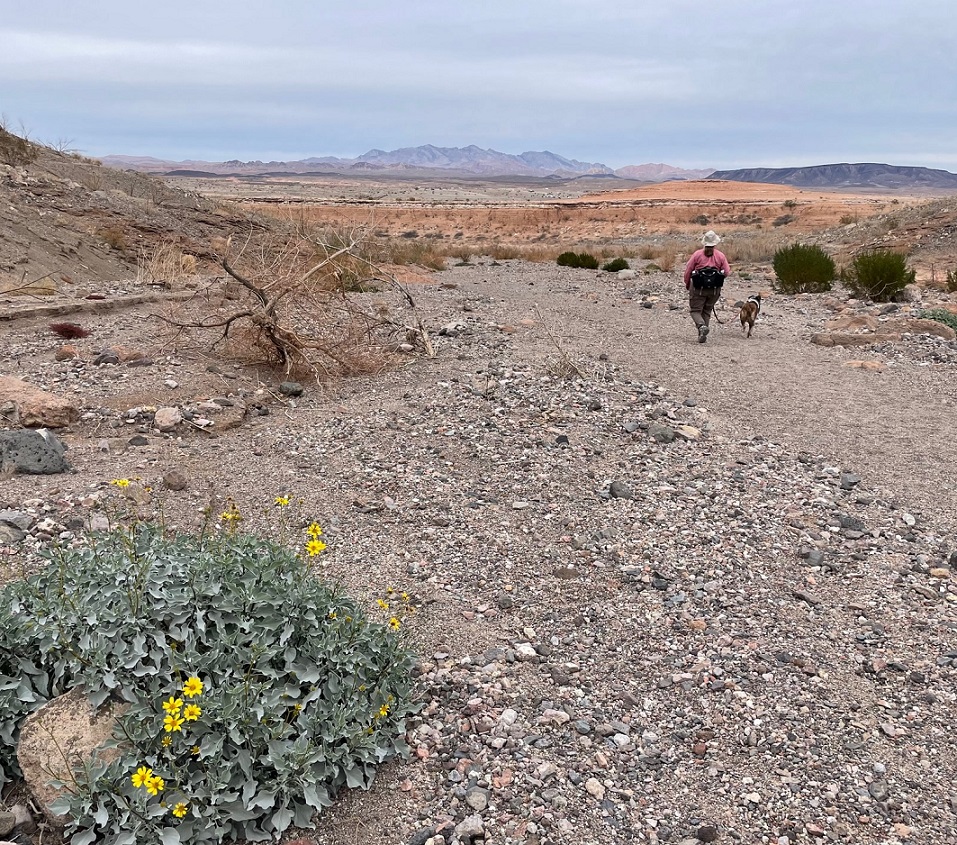
Which neither Nancy, nor Gunther, nor I, are. We lucked into a great hike called the Owl Canyon trail on the first weekend of 2024, and saw some pretty cool sights while enjoying a 4-mile out-and-back trail.
We saw several of these beautiful buttes along the trail to Owl Canyon. The creek flowing below the butte at lower left is Las Vegas Wash, a 12-mile-long arroyo that channels most of the excess water from the Las Vegas metropolitan area into Lake Mead. The wash contains water from urban runoff, reclaimed water from golf courses and parks, and stormwater; in short, it’s probably best to not dip your tin cup in it for a cool, refreshing drink – although the plants and rocks of the wash do filter a lot of the contaminants out of the water before it reaches Lake Mead. This photo was taken perhaps a half-mile from the trailhead, which was a boat ramp that used to provide watercraft with access to Lake Mead. More on that later.Thousands of these small white mollusk shells can be found in several locations along the Owl Canyon trail. They point to a time, years ago, when this entire area was covered by a vast body of water: Lake Mead, which, when it’s full is about 60 percent bigger than the area covered by the city and county of Denver. As recently as the 1980s, mollusks like these were free to frolic or fritter away their days or whatever it is that mollusks do. Now, every foot of the trail we were on is high and dry.
Here we see an intrepid hiker and her ill-behaved dog (it’s Nancy and Gunther) approaching the mouth of Owl Canyon, about a mile and a half from the trailhead on the boat ramp to the west. The canyon can also be accessed by a trailhead resulting in a shorter hike (2.2 miles out and back) coming from the northeast, but we wanted a bit more of a challenge for this first hike of 2024.
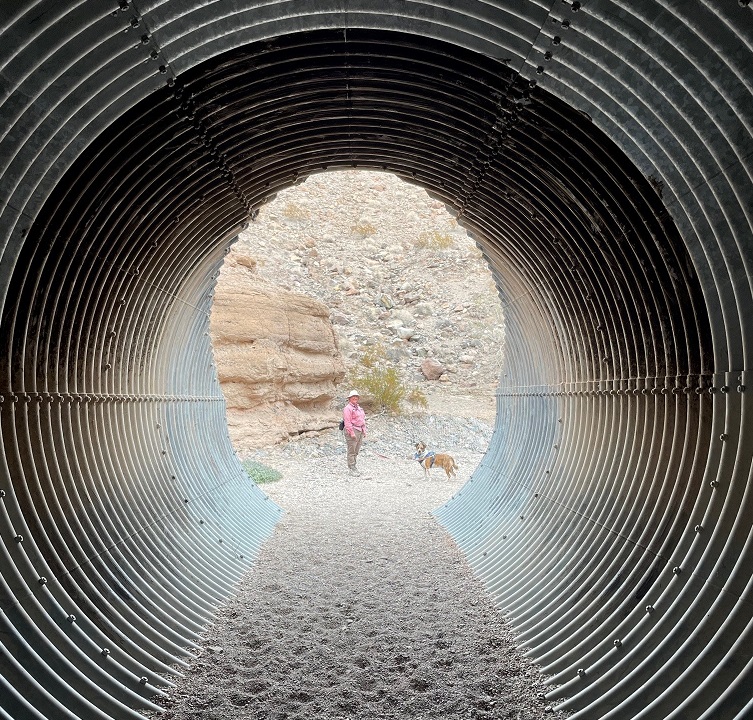
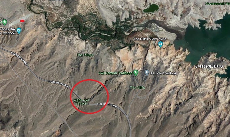
As you can probably tell from the earlier photos, it’s rather arid in the Lake Mead National Recreation Area (it’s in a literal desert, the Mohave, and the region is a convergence of the Mohave, Great Basin, and Sonoran deserts). Depending on which resource you use for reference, the area gets between 4 and 6 inches of precipitation each year. Except for a great blue heron, a small family of mallard ducks, and a large flock of goldfinches, we didn’t see much in the way in wildlife on the day’s hike. However, we did see some examples of desert plants that we hadn’t yet encountered on our travels. This is a specimen of desert stingbush (Eucnide urens), also known as velcro plant. It’s found in the desert regions of the southwestern United States and Baja California. It looks a lot like holly leaves seen around the December holiday, but, true to its name, the serrated leaves have stinging hairs to protect the plant from browsing animals. It’s yet another desert plant one wouldn’t want to lick (although the desert bighorn sheep native to the area seem to like them quite a lot).The walls of the canyon, which were under the waters of Lake Mead for many years, is made of a conglomerate of many different kinds and sizes of rocks, ranging from particles of sand to basalt stones the size of footballs or larger. Owl Canyon existed before Lake Mead; it was carved by an intermittent watercourse to create a winding natural path through the desert.The previous photo of the canyon walls’ conglomerate was taken near a spot in the canyon where we stopped for lunch. This photo was taken from the same spot. It shows Gunther alertly listening to Nancy about further instructions regarding the hike, especially to be constantly aware of impending threats from wildlife. (He’s really just waiting for Nancy to offer him some of her tuna salad sandwich; ultimately, he was disappointed to be denied the same.) The bandana he’s sporting around his neck was acquired gratis from a pet grooming service in Idaho over the summer; it looks like I neglected to iron it before we left on that day’s hike.Owl Canyon gets its name from the many holes in the rock walls that have eroded away, providing perches for owls and other roosting birds. Walking through its winding course was a ton of fun, although Gunther appeared to be ready to leave at any time.Of course, Gunther was right to be terrified. One drawback presented by the canyon’s winding rock walls was the inability to see anything around an upcoming bend, such as these remarkable multi-stone sculptures located just before a culvert in the canyon, until they suddenly appear before you. They were encountered on our return path through the canyon; they weren’t there when we walked through the culvert earlier and gave us something of a start. Their sudden appearance shall forever remain a mystery. (Seriously, a family also walking through the canyon must have put quite a bit of work into stacking these stones, and they did it in pretty short order. Park managers are strict when it comes to building even small piles of rocks: like graffiti on rock walls or otherwise defacing natural resources, despite how cleverly they’re designed, putting these formations together is forbidden.) That’s Lakeshore Road above the culvert.Here are Nancy and Gunther on the other side of the culvert pictured above. Walking through its galvanized confines as we hiked underneath Lakeshore Road was an interesting experience. I found, to Nancy’s delight, that it provided quite an echoing experience. There are two culverts in Owl Canyon; they allow seasonal water runoff to continue on its natural course through the canyon on its way to Lake Mead.Erosion from water and wind creates some spectacular rock carvings. Vertical formations like this, like the much larger butte pictured earlier, are created when the erosional forces of water and wind take away rock material surrounding a structure, but the formation itself is protected on its top by a layer of less permeable rock. I’d guess that this formation at the top of the canyon wall is 12 to 15 feet tall.Nancy and Gunther emerge from the canyon and prepare to return to the trailhead; Gunther, in particular, appears pretty happy to be out. That’s a brittlebush (Encelia farinosa) plant in the lower left, displaying its bright yellow blossoms on this early January day. Perhaps unsurprisingly, brittlebush is a member of the sunflower family.On our walk back to the trailhead, we saw this striking shrub we hadn’t noticed while hiking to the canyon. I inset a closeup of the plant’s leaves in the lower right. It’s a pretty plant, isn’t it, with its deep red limbs and attractive dark green and juniper-like leaf structures? Don’t be fooled! This is the scourge of the southwest, an invasive plant called tamarisk (Tamarix ramosissima) that’s native to Europe and Asia. Land and river managers throughout the southwestern United States spend a lot of resources trying to control the spread of tamarisk, the flowers of which each contain thousands of tiny seeds. Younger tamarisk plants compete with native plants for water along riverways; tamarisk doesn’t grow well in shade, so if the native plants are able to outgrow tamarisk (which can grow to heights of 25 feet in full sun and with sufficient water), the natives will usually win out. This particular plant was growing quite a ways from Las Vegas Wash.This is a view of the length of the boat ramp that now serves as a parking lot for a couple of hiking trailheads, including the Owl Canyon Trail. I took this photo as we were driving away from the trailhead. You can barely make out the white paint on a couple of vehicles parked on the right side of the ramp near its end. Las Vegas Wash is just beyond the end of the ramp. When the lake is full, a lot of this ramp would be underwater. Keep scrolling to see what it would take to get this boat ramp functional for launching boats into Lake Mead again.Here’s some perspective of how low Lake Mead is. This is a screenshot from Google Maps, using satellite imagery taken from about 250 miles above the earth, of the area in which Nancy, Gunther, and I hiked. The boat ramp pictured in the photo above this screenshot is the small gray strip in the upper left corner; we parked the Goddard’s six-wheeled towing unit approximately where the red dot is. Owl Canyon is in the red circle; we hiked from the boat ramp, to and through the canyon, and back again. Las Vegas Wash is the creek at the top of the image flowing into Lake Mead in the upper right corner; when the lake was full, it extended west all the way to cover a lot of the boat ramp on the left side of the image. In short, the end of the boat ramp is at least three miles from the current waters of Lake Mead, and the lake would still need to fill much more in order to actually launch a boat from the ramp. When we finished our hike we happened to meet an construction engineer on the boat ramp who was doing some preliminary evaluation to prepare for its eminent demolition and extraction of the concrete, rebar, and other materials. As he told us, “This lake isn’t filling in our lifetimes.”
It’s easy to think that it’s not the end of the world if Lake Mead continues to dry up: the Colorado River flowed freely through this area for millions of years, supporting all kinds of native plant and animal life. But that’s not the world in which we currently live, and the disappearance of Lake Mead would be an absolute catastrophe: without constant flowing water to turn Hoover Dam’s turbines, many metropolitan areas in the southwest, like Phoenix, Las Vegas, and Los Angeles (to say nothing of the many thousands of smaller cities in the region), would suffer calamitous losses of electricity as well as a reliable source of water. Simply put, water impoundments like Lake Mead (and, to lesser but still vital extents, Lake Powell and Blue Mesa Reservoir upstream) make habitation of the southwest possible. Ain’t nobody living in Phoenix or Las Vegas in the 120-degree temperatures of July without air conditioning provided by electricity, to say nothing of being able to turn a faucet and expect water to come out.
It’s sobering to think that every step we took on this hike was once well underwater in Nancy and my lifetimes. Fortunately, smart and committed people are working on ways to continue developing and encouraging water conservation in the American southwest, but committed people will also need to actually take those steps in order to keep water flowing through Lake Mead.
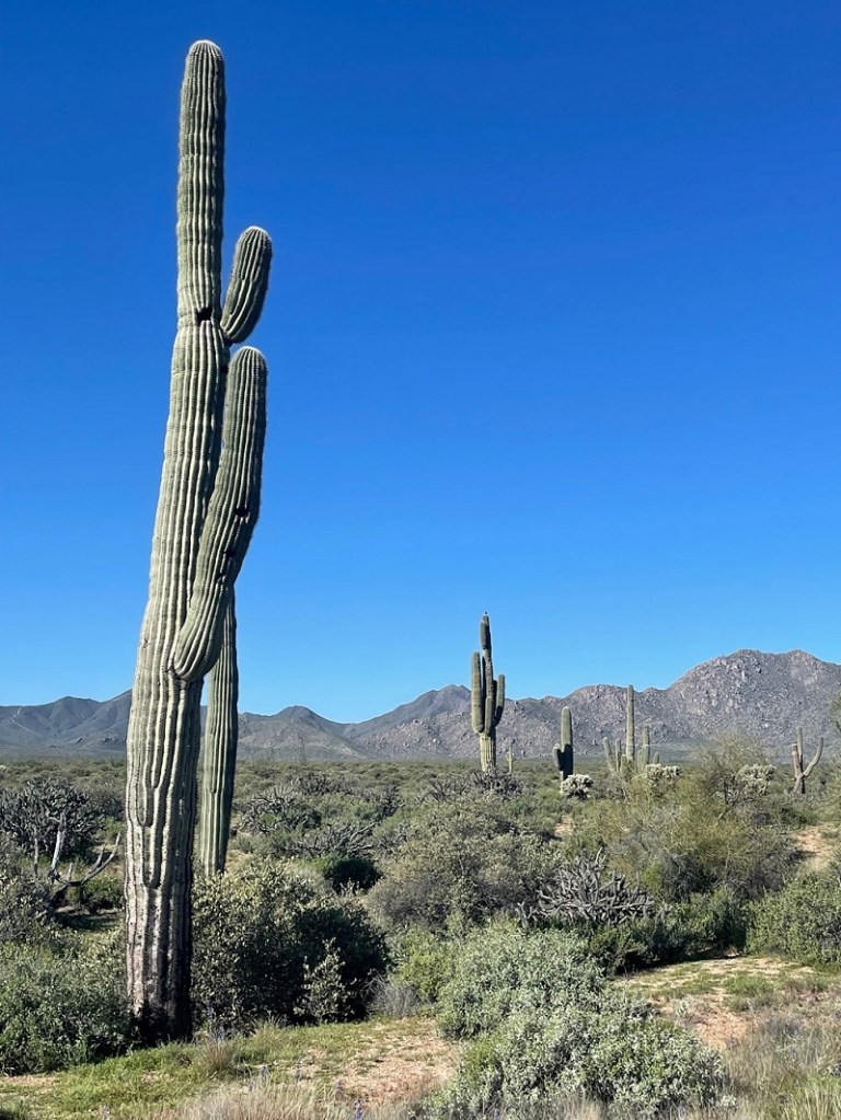
As I related in a previous posting, we spent two weeks of March 2023 in McDowell Mountain Regional Park, a huge protected expanse of land east of the Phoenix, Arizona, metropolitan region. While that posting approached the avian aspects of the park, this one will focus on the floral features of the McDowell Mountain area. Keep in mind that all of these photos were taken in the last two weeks of March, when much of the rest of the western United States was just beginning to emerge from winter. Since Nancy and I are both from Colorado, about the only flowers we’re used to seeing that early in the year are those of crocus, narcissus, tulips and other bulb-born blossoms. The blooms of these flowering plants of the Sonoran Desert provided plenty of color in a landscape that otherwise seemed to be generally green and brown, as seen in the saguaro landscape above. (By the way, if you’re a beer aficionado, in the background you will recognize the four mountain peaks used on the labels of the Tempe, Arizona-based Four Peaks Brewing Company. I’m suddenly in the mood for a Kilt Lifter.)
Like most of the western United States, the Phoenix area received an above-average amount of precipitation during the 2022-2023 winter. That, along with occasional rain showers while we were at McDowell Mountain in March, resulted in some spectacular wildflower displays.
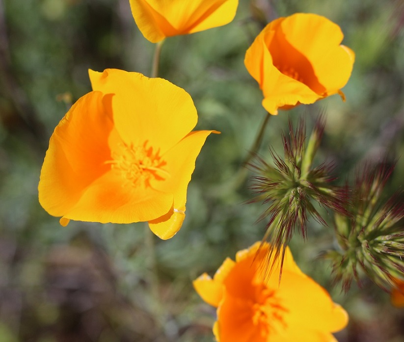
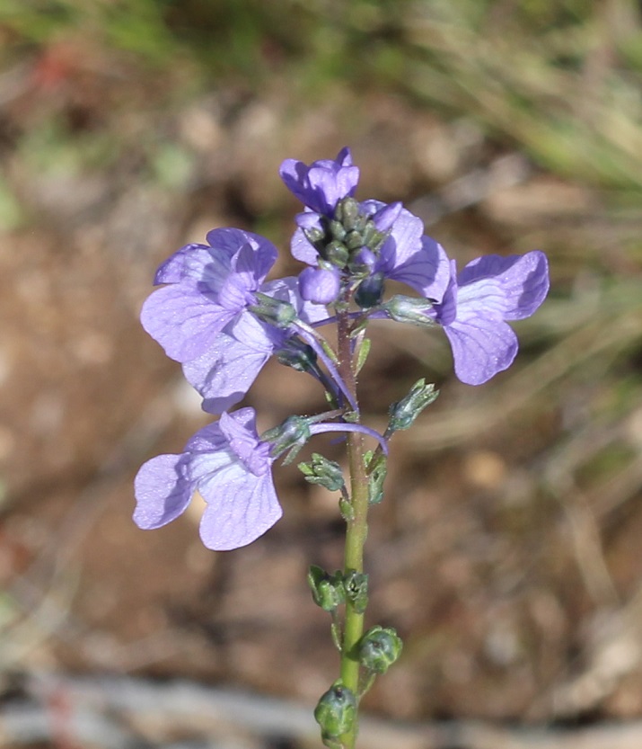
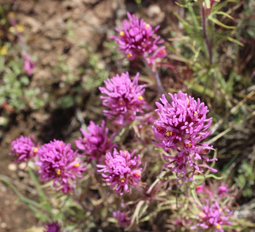
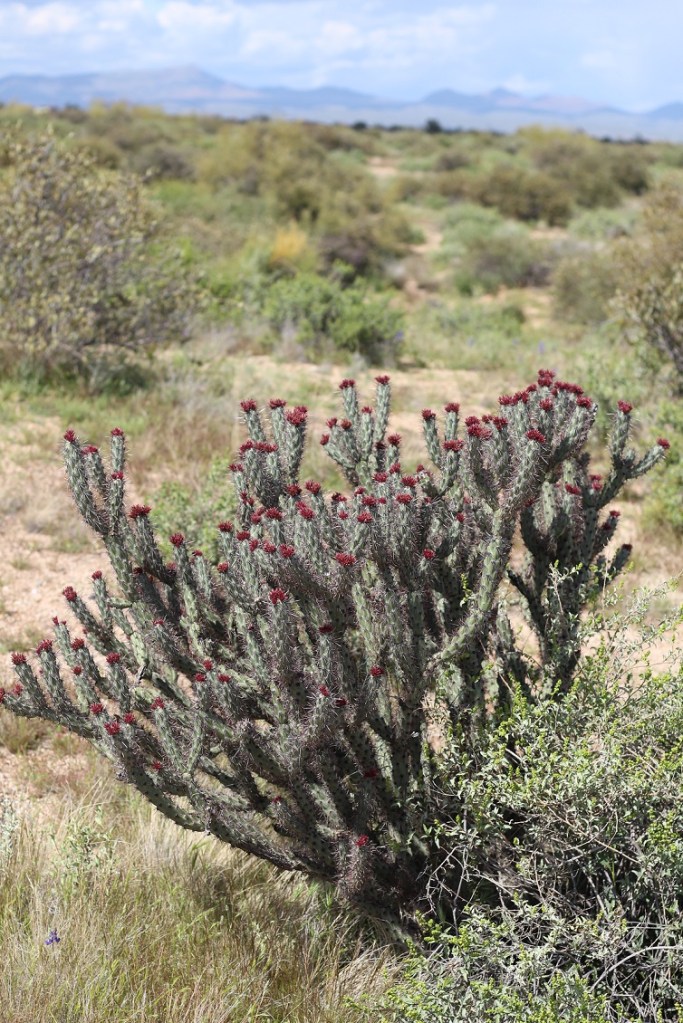
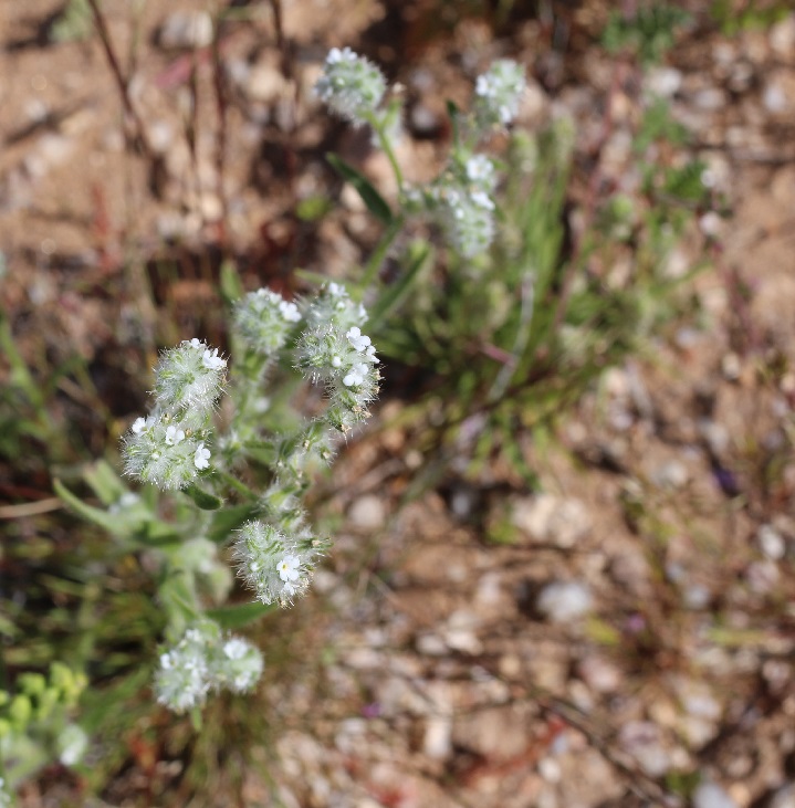
First up is the very common but colorful California poppy (Eschscholtzia californica), of which we saw plenty while in the park. It’s possible that this is another species called Mexican gold poppy, but I do think that, based on the flower coloration, this is the California species. The petals of these flowers close as evening approaches, and then begin to open again when the sun rises.California poppy plants grow to a height of 8 to 24 inches, and their blossoms can be 1 or 2 inches wide. I inadvertently planted a lot of this species in the xeriscaped part of our yard in Denver – the seeds were included in wildflower packets, and after a couple of years the poppies began to take over the area. Still, these plants produce some pretty eye-catching color. The California poppy is the state flower of … California.Texas toadflax (Nuttallanthus texanus), a member of the figwort family of flowers, grows to a height of about 28 inches. It’s a very spindly plant topped with some spectacular flowers that, because of their size, need some closer examination to appreciate; if you just walked by these flowers, it’d be easy to miss their delicate beauty.The bluish-violet color of this toadflax’s flowers is really pretty, I think, as is the complex structure of the blossom. The flowers grow on a structure called a raceme, a stalk in which the youngest flowers grow on smaller stalks at the top and the lower, older blossoms begin to develop into seeds.Castilleja exserta is one of about 200 species of Indian paintbrush found in western North America down through South America. Native to the southwestern part of the country, the plant grows to a height of 4-18 inches. Like all other Indian paintbrush species, exserta Indian paintbrush (also commonly called purple owl’s clover) is parasitic: it gets nearly all of its nutrition by using a specialized organ called a haustorium to attach itself to another plant species. Indian paintbrushes are some of my favorite plants; I tried to grow them at our Denver house next to some buffalograss for sustenance, but to no avail.Ocotillo (Fouquieria splendens) is a common plant seen from west Texas to southern California. They grow to an impressive height of up to 30 feet, and in the spring produce bright red flowers at the top of their many stalks. We were just a tad too early (or maybe too late; I’ve never seen ocotillo in bloom) to see these buds blossom. The flowers, which flower to coincide with hummingbird migrations for their pollination, give the plant its name: ocotillo means “little torch” in Spanish. Ocotillo are really interesting plants: they grow those tiny leaves seen in the above photo after a rainfall, and then drop the leaves when dry conditions return. It’s a cycle that can happen four or five times during the growing season.I think we were also at McDowell Mountain Regional Park too early in the season to see the saguaro cactus (Cereus gigantea) bloom, too. However, we did see some of these mighty cacti beginning to grow new arms, as seen on the left of this photo. Saguaros, which grow to a height of 50 feet, are very long-lived cacti: the oldest are estimated to be 200 years old. They don’t start forming arms like this until the plants are 70 to 100 years old, depending on the amount of precipitation they receive. Saguaro flowers, which grow at the top of the cactus, are white and grow to a width of 3 inches. The blossoms open at night and are pollinated by a variety of insects as well as bats. Saguaro blossoms are the state flower of Arizona.You wouldn’t guess it by looking at Esteve’s pincushion (Chaenactis stevioides), but this pretty plant is a member of the sunflower family. Reaching a height of 4 to 10 inches, it grows across the western United States, from southern Oregon and Idaho, down to New Mexico, and east to Wyoming and Colorado.The park had a lot of buckhorn cholla (Cylindropuntia acanthocarpa) in bloom; these large cacti seemed to be popular perches for birds. Buckhorn cholla cacti, of which there are six varieties, are found in the Sonoran, Mojave, and Colorado deserts of North America.I’d think a bird would find a more comfortable place to perch than on the top of a buckhorn cholla (pr. CHOY-ah), but I suppose they know what they’re doing. We had a different species of cholla along a south-facing exterior wall of our house in Denver; I’ve no idea what species it was (it wasn’t as branching as a buckhorn), but it had pretty flowers in the spring as well.I think of all of the flowers in bloom while we were at the park, desert globemallow (Sphaeralcea ambigua) was probably the most prevalent. It’s the orange-colored flower on the left, and the plant is still used by members of the Shoshoni and other Native Americans as a food and medicine source. It’s very common in Arizona; at another camping spot in the extreme northern part of the state later in the year, we’d drive by fields of it in which the blooms probably numbered in the millions. It is a popular cultivar for home xeriscaped gardens. The yellow flower on the right is brittlebrush (Encelia farinosa), which we first encountered at southeastern Arizona’s Gila Box Riparian National Conservation Area in January 2022. Its growth habit varies widely; it can be a foot tall or grow to a height of 5 feet.Here’s a closer view of the brittlebush flowers. It derives its name from the delicate nature of its flower stems. The plant’s sticky sap lent itself to a wide variety of uses among Native Americans and early pioneers in the southwestern United States, including as a glue, a sealant, and a waterproofing agent. It, along with the desert globemallow, was everywhere in the park. The plant is commonly found in the southwestern United States and northern Mexico.While its flowers are attractive enough, I really liked the foliage of redstem stork’s bill (Erodium cicutarium). This is not a native of the southwestern United States; it was brought to this country in the 1700s from the Mediterranean region of Eurasia and northern Africa. This plant has an interesting seed distribution system; in a process known as explosive dispersal, part of the flower changes its shape into something of a coil and stores up elastic energy. When enough energy has been created, that part of the flower, including the seed, bursts away from the plant. Once on the ground, the part of the flower containing the seed waits until soil conditions become wet enough for it to bury itself into the ground and germinate.Here’s one more cactus, the teddybear cholla (Opuntia bigelovii) that, again, was not in bloom while we were at the park (the yellow-green flowers are a couple of inches wide). I took this photo after a brief late-afternoon rain shower and liked the lighting. Despite its name, this is not a plant you’d like to even get close to: its small joints will readily detach from the main plant at the slightest touch (it’s also known as jumping cholla), and the spines have backward-facing barbs to ensure that they stick. On walks around the park with Gunther, we’d see a lot of these cacti with little balls of spines at their bases. Teddybear cholla grow to heights of 3 feet up to a truly terrifying 9 feet.Let’s move on to something less threatening. Here’s panamint cryptantha (Johnstonella angustifolia), also known as panamint catseye. It’s native to the southwestern United States and northern Mexico. It grows to a height of 2 to 12 inches, and is an annual wildflower – the plant produces flowers which develop into seeds, and, although the original plant dies, those seeds produce new plants the following growing season. In a very harsh desert landscape filled with plants covered in thorns, spikes, barbs, needles, and other sharp things, it was nice to find a relatively soft-looking flower.To wit: even this Menzie’s fiddleneck (Amsinckia menziesii) has small barbs on it (to say nothing of the thorns of the neighboring fishhook cactus in the lower left). Its seeds are a favored food for goldfinches (who’d have to be pretty hungry to get past the cactus thorns). The flower head of a fiddleneck sometimes curls gracefully into the shape of the head of a violin, giving the plant its name.I’ve enjoyed seeing the creosote bush (Amsinckia menziesii) in our travels around New Mexico and Arizona, and it was neat to see one in bloom. The smell of a creosote bush, especially after a rain, is really wonderful. A creosote bush creates clones of itself as it grows older – typically around the age of 60 to 90 years. Eventually the interior original plant dies, but it is surrounded by a ring of its clones. A ring of creosote in California’s Mojave Desert, called “King Clone,” is estimated to be nearly 12,000 years old – it’s one of the oldest organisms on the planet.I’ll close with this image of a fairy duster (Calliandra eriophylla) that I took perhaps 20 yards from the Goddard’s campsite. Fairy dusters, which grow to a height of between 8 and 20 inches, are fairly ho-hum shrubs for most of the year, but they produce some spectacular flowers in the spring.
There are several more photos I could include, but I think this posting has shown the incredible variety – the color, the blossom structure, the life cycles – of flowering plants in the Sonoran Desert. As was the case with the birds of McDowell Mountain Regional Park, I was really struck by the tremendous depth and breadth of the flower species variation. To be sure, the desert doesn’t look like this year-round, and it had been an especially wet winter and early spring, but under the right conditions a walk around the Sonoran Desert can be incredibly rewarding – as long as you don’t walk into a teddybear cholla.
Much of the identification of these plants was made possible by referencing the National Audubon Society’s Field Guide to North American Wildflowers, Western Region (ISBN 0-394-50431-3). Additional information came from Wikipedia, which I lean on pretty heavily for a lot of what I write – if you use Wikipedia much at all, please consider supporting it. I recognize that it’s not the end-all, be-all of sourcing information, but it’s a great starting point as a resource and available to everyone with an Internet connection.
McDowell Mountain Regional Park is one of 14 parks in Maricopa County that have been preserved as open spaces and protected against private development – an important consideration for the Phoenix metropolitan area, one of the fastest-growing parts of the country. Some of the regional parks offer camping, and the Goddard spent two weeks in March in the shadow of McDowell Mountain, surrounded by saguaros and sparrows – along with a surprising diversity of other plants and birds.
Here’s a look at some of the Sonoran Desert birds we saw during that two-week stay. I was expecting to see at least some birds, but I wasn’t expecting to see some of the species that we actually did, nor the quantities of birds and different bird species that we saw. Keep in mind that most of these pictures were taken very close to our campsite – some were taken from our fifth-wheel’s steps – and all were taken no more than a quarter mile away from the Goddard.
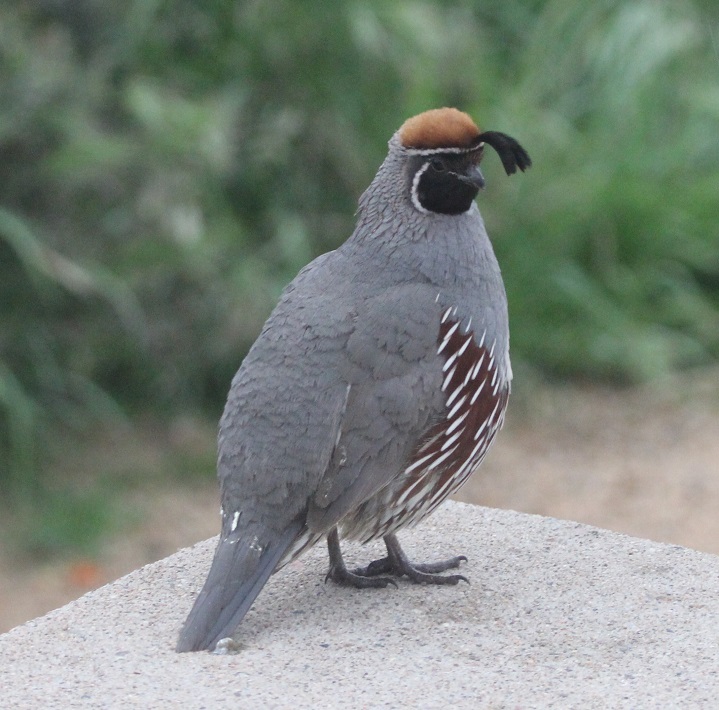
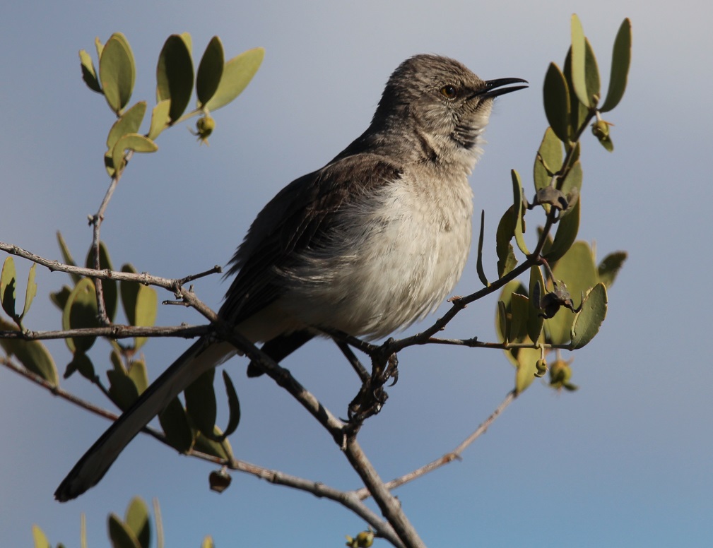
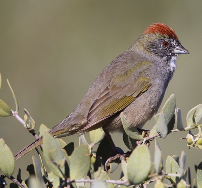
McDowell Mountain Regional Park, situated east of the city of Phoenix, protects just under 22,000 acres (about 34 square miles) of the Sonoran Desert for public use. The park is at the northern reaches of the desert, which itself contains more than 100,000 square miles stretching from southern Arizona down into northwestern Mexico and Baja California. There are plenty of saguaros and other cacti species in the park, along with a tremendous variety of other succulents, shrubs, wildflowers, and grasses. I’m working on a different blog posting that highlights the flowers that were in bloom during our stay in the park – I was really surprised at the variety.This is a female Gila woodpecker (Malanerpes uropygialis), one of the more characteristic birds of the Sonoran desert. Gila (pr. HEE-la) woodpeckers make their nests, containing 3-5 eggs, high up in saguaros, as seen here, and trees. In the United States, these birds are found only the extreme southern areas of the southwest. Male Gila woodpeckers look identical to the female, with the exception of a bright red cap on the top of their head.We’d seen Gambel’s quail (Callipepla gambelii) before, including at a campground in Deming, New Mexico. However, we’d never been close enough to get some decent photos. I took this while standing on the steps of the Goddard and this male quail was standing on our campsite’s concrete picnic table perhaps a dozen feet away. We saw quite a few of these beautiful birds during our stay at the park, and heard a lot more once we learned what their distinctive calls sound like (play the soundfile below, if you dare). Gambel’s quail nests contain between 10-20 eggs. The birds, native to the extreme southwestern United States and introduced in western New Mexico, are usually found on the ground, although we did see a few on top of saguaros (and our picnic table). Gambel’s quail are named after ornithologist and naturalist William Gambel (1823–1849), who at the age of 18 traveled overland to California. He was the first botanist to collect species in Santa Fe, New Mexico, as well as parts of California. A genus of southwestern U.S. lizards is also named in his honor.Nancy took this photo of a black-throated sparrow (Amphispiza bilineata) while perched in her camp chair right next to the Goddard; the sparrow was perched atop a buckhorn cholla that’s about to bloom. Both sexes of this species have the same plumage. These birds, also known as desert sparrows, are remarkably well-adapted to the hot and arid conditions of the Sonoran; during the heat of summer, they derive all the moisture they need from eating insects and seeds. Which is good: at the time of this late-afternoon writing in late July 2023 (we’re currently in southern Idaho), it’s 110 degrees at McDowell Mountain Regional Park. There are 26 species of sparrows in the United States, and most of them are generally brown. The black-throated sparrow is easy to identify, though. (Photo credit: Nancy Jardee)Although I’d read in the park’s literature that this species could be found in the area, it was still a pleasant surprise to see a loggerhead shrike (Lanius ludovicianus) while on a short hike around the campground. I’d never knowingly seen one before, but I’d read quite a lot about them: they feed mostly on insects but will also hunt for mice, lizards, and other small birds when times are tough. Additionally, although this one looks fairly innocuous (that savage hook at the end of his beak notwithstanding), shrikes impale their food on barbed wire or thorns as a means of storage, earning them the nickname “butcher birds.” This curve-billed thrasher (Toxostoma curvirostra) is perched atop a saguaro. I never did quite get used to seeing birds on top of cactus thorns, but I guess they don’t have a problem with it. When they’re not perched on a cactus, curve-billed thrashers spend a lot of time on the ground looking for insects. The look on these thrashers’ faces always reminds me of Sam the Eagle from “The Muppet Show.” I first saw one of these birds at the Tucson Botanical Garden.Since first seeing a northern mockingbird (Mimus polyglottos) near Tulsa, Oklahoma, in 2022, we’ve managed to see plenty of them all over the country. I wonder if it is due to the Baader-Meinhof Phenomenon, like when you learn a new word and then see it a lot in the next few days. Anyway, they’re fun to see and quite enjoyable to listen to – some are capable of learning 200 songs throughout their lives.While I wasn’t particularly surprised to see a northern mockingbird, I was surprised to see this northern cardinal (Cardinalis cardinalis) in the Sonoran Desert. It urns out that the species, while limited mostly to the eastern United States and Mexico, does have an established habitat in southern Arizona. Even though this guy was perhaps 75 yards away, he definitely caught my eye (I also heard his call to let me know in which direction to look). Only a few female bird species sing, and the northern cardinal is one of those species. Interestingly, northern cardinals don’t migrate – they stay in one location all year long.This is a composite image of a female (left) and a male (right) phainopepla (Phainopepla nitens), which are found in the southwestern United States and Mexico. We’ve seen them in Silver City, New Mexico, quite a bit. Absolutely beautiful birds. Their Latin name means “shining robe.” Phainopepla (pr. fay-no-PEP-luh) have evolved to eat mistletoe berries, which are low in nutrients but the birds can eat more than a thousand of them in a day. They can mimic the calls of other birds, including the Gambel’s quail. This is one of the species that has red eyes – there are several theories for that, but one I like is that there is a high concentration of blood vessels in their eyes to help with blood circulation. This pair liked to hang out on the same tree at the same time every morning – very dependable, which is a nice attribute for a bird. Here’s a first-for-me bird: the green-tailed towhee (Pipilo chlorurus). The species, which is only found in the western part of the country, migrates to the northern states for breeding but lives year-round in southern and central Arizona. They are very secretive and can be difficult to see. This guy was hanging out near our picnic table as I got back from a birding walk; I should have just stayed home.A small flock of white-crowned sparrows (Zonotrichia leucophrys) took up residence in a thorny thicket of mesquite along one of the hiking trails near our campground. This species, one of the few sparrows that’s relatively easy to identify, overwinters in the southern United States and is found seasonally all over the country, as well as Canada and Mexico – Alaskan white-crowned sparrows fly 2,600 miles to spend their winters in sunny southern California. One white-crowned sparrow was recorded flying 300 miles – about the distance between Colorado’s northern and southern borders – in a single night.One more sparrow, which I am 98% sure is a Lincoln’s sparrow (Melospiza lincolnii). They are found at least seasonally all over North America and Mexico, with the exception of the southeastern part of the country and extreme northern Canada. This species is not named after the luxury division of Fort Motor Company, as one might think, but rather after Thomas Lincoln, a chum of noted birder John James Audubon. Of the 26 species of sparrows, I can identify only three (house, black-throated, and white-crowned) conclusively. Anyway, almost 12 percent of the North American sparrows are on this blog posting.I’ll close with the cactus wren (Campylorhynchus brunneicapillus), one of the more characteristic birds of the American southwest. In fact, it’s the state bird of Arizona. It’s a noisy little guy, with a call that has been likened to someone trying, and failing, to start a car (reference soundfile below). They are one of the few bird species that roosts in nests throughout the year instead of only during the nesting season.
Nancy and I sort of started birdwatching before we sold our house two years ago, but we’re pretty full-bore into it now. We’re very fortunate to live the way we do, with opportunities to enjoy the tremendous variety of birds in different parts of the country.
We’re not the most expert birdwatchers on the Goddard, though. Rusty shows us how it’s done:
The Goddard spent the fall and winter of 2021-2022 in New Mexico and then Arizona, and in the spring we headed back north to visit Colorado for a while. Spring is a great time to watch birds: they’re very active as they gather material for nests and later find food for their fledglings. Leaves on trees also begin to emerge as the weather warms up, which I was to discover makes photographing birds much more difficult than in the fall and winter.
Here are some birds we saw doing their spring thing in Arizona, New Mexico, and Colorado.
Holbrook, Arizona
Our campground in Holbrook was next to a residential area, which doesn’t happen very often because usually campgrounds are on the outskirts of towns. It gave us a chance to walk by houses and see birds perched in the trees.
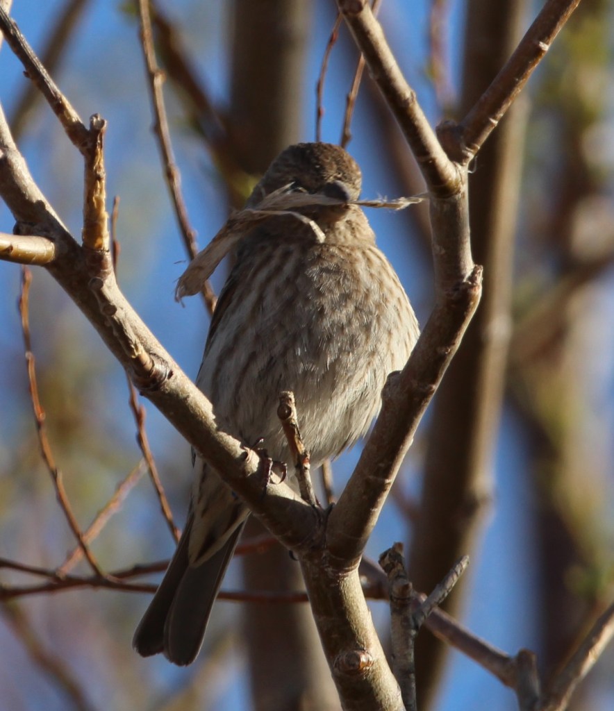
This female house finch was busy gathering materials for a nest at our campground in Hollbrook. Finches have really pretty songs, and they’re enjoyable to listen to in the morning. House finches are an interesting story: they’re native to the American southwest and Mexico, but profiteers captured some finches in the 1940s and attempted to sell them as “Hollywood finches” to bird enthusiasts in New York City. Rather than face prosecution for violating a federal law regarding migratory birds, the people released the finches into the wild and the birds established themselves on the U.S. east coast. In the ensuing years, they’ve moved both east (from the southwest) and west (from the east coast) to be found across nearly the entire country.Here is the mate of the house finch, watching the sunrise the same morning. I’m sure he later helped build the nest, too. The reddish coloration of male house finches changes with the seasons and is dependent on the birds’ diets; as you’ll see, some male house finches are redder than others. For their size, finches have some powerful beaks.This is a very common bird, the house sparrow, but it’s a very pretty one all the same. Mornings are a great time to take photographs of birds because the sun is low in the sky to provide dramatic lighting, and the birds themselves are fairly active.
Grants, New Mexico
The campground at which we stayed in Grants, New Mexico, at the end of March had an adjacent walking trail that wound through a lava field. A relatively recent volcanic eruption, perhaps only 4,000 to 5,000 years ago, produced the black basaltic rock that is everywhere around Grants. The campground’s trail attracted a lot of birds that perched on the trees and shrubs within the lava field, including this female white-crowned sparrow that was singing a pretty song one morning. It was the fifth species of sparrow I’d seen during our stays in New Mexico and Arizona. We really enjoyed this trail, which also provided great views of the surrounding mountains. A national monument, El Malpais (Spanish for “the badlands”) is very near Grants, and we look forward to visiting it in the future.Here’s the other male house finch I alluded to earlier. Dunno what he’s eating to get all of that red coloration, but he’s definitely the reddest finch I’ve ever seen. This was in the campground at Grants; I have a bunch of photos of different birds perched on different types of water valves at campgrounds, for some reason.
Albuquerque, New Mexico
Our next stop on our return north was Albuquerque, which Nancy and I really enjoy visiting. There’s a lot to see and do there, and plenty of great Mexican restaurants and grocery stores to enjoy.
We returned to Albuquerque’s excellent Botanic Garden at the city’s BioPark, which also has a zoo and aquarium situated along the Rio Grande near downtown. In early April the garden had thousands of blooming bulbs, including daffodils, tulips, crocus, and others, as well as a lot of neat birds. This is a male white-crowned sparrow; compare him to the pretty female white-crowned sparrow from the Grants lava field, two photos above. This guy was hunting for bugs on one of the garden’s trails.We watched this mountain bluebird bring a grub to its nest in a tree near the Botanic Garden’s farmstead exhibit. I really like the hue of blue, which contrasts nicely with their rusty chests, on these birds.Gunther and I went for a walk on a trail along the Rio Grande bosque one afternoon and I heard this fellow singing in a cottonwood tree. I couldn’t tell what kind of bird it was at the time because it was so far away, but I got a couple of photos with my telephoto lens. I was a little surprised to see, after looking at it on my laptop, that it’s a spotted towhee. I’d never seen one in a tree before; I’ve only seen them on the ground, scratching through leaves while looking for bugs. (Of course, the next day we went to the city’s Botanic Garden and we saw another spotted towhee there, in a tree.) Spotted towhees are really pretty birds – they’ve got a lot of patterns and colors going on.On that same walk we saw several wood ducks, including this very striking drake, swimming in a canal adjacent to the Rio Grande. I’d never seen wood ducks prior to our first stop in Albuquerque last November. They’re just incredibly beautiful birds (and the hens are quite pretty as well).
Las Vegas, New Mexico
In mid-April we made our way to Las Vegas, which we had also stayed at the previous fall. It was incredibly windy during our stay there in the spring (and the area would be subjected to several wildfires shortly after we left), so we didn’t venture out much. I did take a few photos at the campground, though.
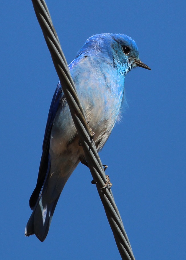
This is a western bluebird, perched on a power line and watching me as I watched it. This is the same species from the cottonwood tree in the Albuquerque Botanic Garden. I’m writing this post while camping in central Arkansas, and I kind of miss those clear blue skies of New Mexico and Arizona. We sure don’t miss the wind, though.Writing about blue skies: this mountain bluebird nearly disappears into them. We’ve seen this species in Colorado several times, including at the cabin near Eleven Mile Reservoir. You can see that the wind was blowing: look at the feathers on his chest.
Lathrop State Park, near Walsenburg, Colorado
We returned to Colorado around the end of April, choosing to camp once again at one of our favorite state parks. Located west of Walsenburg in the southern part of the state, Lathrop State Park has two large lakes, good hiking trails, and incredible views of the Spanish Peaks and Blanca Peak, each of which still had snow. The park attracts an enormous number of permanent and migratory birds each year.
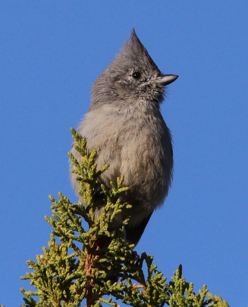
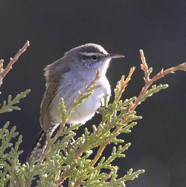
We’d seen a couple of American robins, our first of the spring, at the Albuquerque Botanic Garden, but I couldn’t get any good photos. There were plenty of robins at Lathrop. I’ve learned to recognize their calls, which are really distinctive once you’ve heard them enough.I hiked through the cactus and brush (you’ll notice that most of these songbirds at Lathrop are perched on juniper) north of our campsite one morning and took this photo. I had no idea what kind of bird it was until I looked it up: it’s a tufted titmouse, at the very northern edge of its range in southern Colorado. I’d never heard of them, let alone seen one before. Neat-looking bird, although you don’t see many species, outside of bluebirds and blackbirds, that are all one color.Here’s another new bird to me, from the same morning hike: it’s a Bewick’s wren. I couldn’t get on the other side of it to take advantage of the morning sun, but I kind of like this backlit effect anyway. I’d never seen too many species of wrens before we started full-timing in the Goddard; I’ve since seen several, and they’re very attractive little birds.This is a cropped photo taken with a telephoto lens from a long, long way from this bird, but I’d never seen one before. This is a pied-billed grebe swimming on one of the park’s lakes, and it spent more time submerged than swimming on the surface. I saw eight bird species at Lathrop State Park that I hadn’t yet seen in 2022, and three of them (the last three pictured) were species I’d never seen at all.There were lots and lots of chipping sparrows at Lathrop. I’m not sure if there were more of these or if there were more American robins at the park (and there were a lot of blackbilled magpies, too). Very pretty calls from these little birds.
By the time we left Lathrop State Park on April 24, I’d seen 51 different species of birds in three different states in 2022. It had become obvious that being around water, whether it’s a river or a lake, greatly increases both the chance of seeing birds and the opportunity to see different species of birds. That would become even more clear at the next Colorado state park at which we’d camp.
We made our first visit to Petrified Forest National Park on March 25, 2022, restricting our time to only the northern, smaller section of the park. That part doesn’t have much in the way of petrified wood, but it has plenty of awe-inspiring views. We returned the next day, with Gunther, to experience the southern side, and we did see some fossilized wood. And how!
Petrified Forest National Park, which measures about 350 square miles, receives about 600,000 visitors per year. That number, while impressive, makes it just the third-most-visited national park in Arizona, following Saguaro National Park in Tucson (1 million visitors per year; Nancy and I were two of those people a couple of weeks earlier) and the most-visited park in all the land, Grand Canyon National Park (4.5 million). Incidentally, Rocky Mountain National Park in north-central Colorado is just behind Grand Canyon, at 4.4 million visitors per year. If you’ve been to Rocky Mountain National Park in the last 20 years and felt a bit cramped, it’s probably due to 4.4 million other people visiting a park measuring 415 square miles.
Wind and water erosion in the northern Arizona desert does some interesting things to rocks, like resting the one on the right side against the one on the left.
But we’re here to talk about rocks. A piece of petrified wood isn’t really wood any longer: it no longer contains any organic material and it is most definitely a rock. The process of petrification takes several important factors, including a tree, water, sediment, and time. Lots and lots of time.
Many of the rocks at Petrified Forest National Park represent trees that were quite large when they were living, about 220 million years ago. Here we see a park visitor with her dog observing a massive rock. (It’s Nancy, with Gunther, who appears ready to return home to The Goddard but we’d only been at the park for about 30 minutes at this point.)
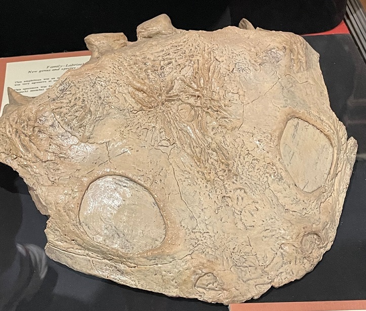
Let’s start at the beginning. The scientists believe that the trees in Petrified Forest National Park were alive between 210 and 227 million years ago. At that time, the Late Triassic Period, the current area of the park was just north of the equator – in fact, it was close to where Costa Rica is today. The land was much different then: covered with forests of immense trees as well as large rivers and other wetlands. Huge amphibians and early dinosaurs roamed the forests and dwelled in the rivers. (Although there were many dinosaur species in the ensuing years, famous dinosaurs such as Tyrannosaurus rex and Triceratops wouldn’t appear until the Late Cretaceous Period, almost 160 million years later.)
There’s still a lot of detail from the former trees to be seen in their petrified logs. While it appears that the logs have been cut with a chainsaw to achieve those smooth sides, they’ve simply cracked along the crystalline structure of the quartz. That usually happens because of erosional processes: either geologic uplift over millions of years, or supporting materials below the log being removed through relatively quick wind or water action.
Many of these coniferous trees (there are nine species identified in the park; all are now extinct) grew to be enormous: some may have grown to 200 feet in height. When the trees died they lost their branches and bark, then eventually toppled over after being undercut by a river. If the tree fell into the river, it may have eventually been covered in sediment being carried by the waterway. This relatively rapid burial is critical to later petrification: the water sealed the dead tree away from both oxygen and bacteria, which helped prevent decay. That delay gave time for silicic acid in the rivers to percolate throughout the tree. This process chemically altered the wood into a mineral called opal that still retained the tree’s fine features, like the grain of the wood, or indications of where branches once sprouted from the trunk.
This is one of the biggest, if not longest, pieces of fossilized wood in Petrified Forest National Park. “Old Faithful” is 35 feet long and weighs about 44 tons. It’s also one of the relatively few logs that retained part of its root structure, which measures 10 feet across today, during the petrification process. In 1962, lightning struck and fractured this log. The National Park Service used mortar to reattach the pieces and added the retaining wall seen near the base of the former tree – a process that, in the name of resource management, the NPS would probably not undertake today. Old Faithful is located just west of the Rainbow Forest Museum and Visitor Center near the park’s southern entrance.Here we see a park visitor with her faithful dog, standing next to the base of Old Faithful. (It’s Nancy, again, with Gunther, again; the dog appears to have perked up somewhat.)While perhaps not quite as spectacular as the views we enjoyed in the northern part of the park the day before, there were still great vistas to enjoy on the Giant Logs Trail near the visitor center. One can see erosional forces still at work on the rocks at right.
Converting the wood into opal took only a few thousand years. Further layers of sedimentation over millions upon millions of years would cover the logs with tons upon tons of soil and rock. This process recrystallized the logs, converting the opal into quartz and a few other minerals. Over many other ensuing millions of years, erosion and geologic upheaval brought the logs back to the surface of the earth to once again see the light of day – this time as petrified wood.
Now that you know the factors involved in creating petrified wood, can you name the states in our country that contain it? The answer is below – keep on scrollin’!
The silicic acid in ancient waterways percolated through fallen logs, converting the trees’ organic material into opal. This closeup photo shows that the minerals retained the features of the trees, such as the grain of the wood.
The visitor center at the southern end of the park, which is part of the original monument created in 1906 (it was made a national park in 1962), contains some interesting fossils of both trees and animals. The fossilized remains of many amphibians and some dinosaurs dating to the time that the trees were alive have been discovered in the park (and the process for creating animal fossils is much the same as that used to create petrified wood). The museum also exhibits some handwritten letters: apparently, some visitors over the years were unable to withstand the temptation (and federal law) to leave the petrified wood where it lay within the park. Upon their return home with a fossilized wood souvenir, some of them inexplicably fell into bad fortune, such as personal or business relationship issues, and returned the rocks via mail, with an apologetic letter, to the national park.
Some of the many trails within the southern part of the park feature these helpful fossilized logs to help keep hikers on the path. Walking beside them gives an idea of just how tall these trees were.
After going to the visitor center and museum, and walking the Giant Logs Trail behind the building, we decided to go on a longer walk to see some more rocks. The Long Logs Trail, located a short distance from the visitor center, is so named because some of the petrified wood is more than 180 feet in length.
We saw this horned lark while on the Long Logs Trail. It had a very pretty song. We had never seen one before, and were happy to watch and listen to it for a while. (I write “we,” but Gunther couldn’t possibly have cared less.)More than 1,200 archeological sites, indicating prior human habitation as long as 12,000 years ago, have been found in the park. The Native Americans arrived first as nomadic cultures, then over the centuries began to occupy the area on a seasonal basis. Eventually, the cultures lived in what is now the park year-round. A short spur from the Long Logs Trail leads to Agate House, a building that was reconstructed by the NPS to represent an actual seven-room dwelling built by ancient Native Americans, using the only construction material available, petrified wood, about a thousand years ago. Although centuries of weathering caused the original structure to collapse, park service staff used the same rocks to rebuild the house.Realizing it’s a reconstruction, Agate House is still very pretty and was probably fairly resistant to the elements when it was first built.
About the states that contain petrified wood: were you able to name them? If you named all 50, you’re correct. Although each U.S. state contain some amount of petrified wood, northern Arizona is able to display one of the largest concentrations in the nation because of the geologic upheaval processes that brought the logs to the surface of the earth.
This particular log caught my eye because of the many colors it features. It’s simply spectacular. The different mineral composition within the petrified wood contributes to the varied coloration. The rocks can contain natural quartz, which is nearly clear and translucent, as well as varying amounts of iron, copper, manganese, and chromium, all responsible for the reds, yellows, purples, and greens. I would never take any rocks from Petrified Forest National Park. It would have meant that someone else wouldn’t have been able to see this one. However, if I was going to take a rock home, this would have been the one. But we have a weight limit, for towing safety purposes. on The Goddard. Also, I like my luck the way it is.
Progressing east and west, Interstate 40 divides Petrified Forest National Park into northern and southern sections. The interstate generally follows the path of historic U.S. Route 66, which connected the midwestern United States to the country’s west coast in the first half of the 20th century. Although Route 66 stretched more than 2,200 miles from Chicago to Los Angeles, Petrified Forest is the only national park with former segments of the historic highway within its boundaries. The area south of the interstate, much larger in size than the northern part, contains most of the petrified wood specimens in the park. The northern area, however, boasts incredible roadside vistas of the Painted Desert and a sizable national wilderness area. Nancy and I visited the northern part of the park in late March. Gunther stayed with Rusty in the Goddard, but Nancy and I would enjoy the dog’s company when we returned to the park the following day.
We briefly stopped in at the northern visitor center, which was undergoing significant renovation at the time, then proceeded to drive along a route that included a number of overlooks of Petrified Forest National Park.
I decided to use my 14mm wide-angle lens for taking pictures the day we visited the Painted Desert. I got it a couple of years ago to primarily take pictures of the night sky but thought its properties would help capture the feeling of the vast open landscapes of Petrified Forest National Park. There is a disadvantage to using this lens, though: it’s not automatic, so the aperture, ISO, and other settings all must be set manually. I’m no good at any of that. Many of the photos I took were over- or under-exposed, and I had to make manual adjustments using a couple of pieces of photo editing software.
One gets a different perspective of time and distance when visiting this part of Petrified Forest National Park. The different colors in the gullies in the center of the photograph represent 200 million years of sediment being laid down by rivers and then being eroded by later rivers, and the rock formation on the horizon at left, Pilot Rock, is nearly seven miles away. The horizon in the center is much further – perhaps a hundred miles.This view of a deep basin formed from erosion is from one of the first overlooks on a road that goes through the Painted Desert. One can see for, literally, a hundred miles to the horizon. They’re not visible in this photo, but we could see many, many tractor-trailers traversing Interstate 40 on the other side of this huge basin. Sharp-eyed viewers will, however, note a distinct lack of petrified wood in this view; that’s because most of the petrified logs are well south of this part of the park.
Petrified Forest National Park contains only a small part of the Painted Desert, which stretches across almost 8,000 square miles of northeastern Arizona. The colorful rocks, primarily mudstone and sandstone, of this region are called the Chinle Formation. Deposited from 227 to 205 million years ago during the Late Triassic Period while most of the land area on Earth was on the single supercontinent Pangaea, the rocks have been buried, lifted, and eroded during Pangaea’s breakup and shift into today’s major continents.
There are still living trees to be found in Petrified Forest National Park, but they’re nothing like the towering conifers that grew 200 million years ago when the area was located at about present-day Costa Rica. The park’s overlooks are built on a layer of basaltic rock that was ejected from volcanic eruptions only between 16 and five million years ago, forming a protective layer that is much more resistant to erosion than the sedimentary layers of rock below.
During the Late Triassic Period, the land comprising Arizona’s Petrified Forest National Park was located just north of the equator and supported a much different environment (different enough, for example, to support a forest of 180-foot-tall trees that would later become petrified). As Pangaea divided, the land mass migrated north and the land itself underwent massive changes.
The different colors seen in the Painted Desert are quite impressive. Large river systems flowed through this area hundreds of millions of years ago, depositing many layers of gravel, silt, and sand. The different colors of the layers are created by varying mineral content of the soils, which have been exposed through geologic movement as well as water and wind erosion.
The Chinle Formation is itself divided into five members: Mesa Redondo, Blue Mesa, Sonsela, Petrified Forest, and Owl Rock. Each member represents a transition of the land from wet to dry environments over millions of years: the Mesa Redondo, the oldest layer and therefore the one underlying the rest of the formation, consists of red sandstone originally laid down 226 million years ago, and the youngest, Owl Rock, includes pink and orange mudstone at the top of the formation that was deposited 207 million years ago.
Here we see a visitor to Petrified Forest National Park (it’s Nancy) contemplate more than 200 million years of geologic change that resulted in these magnificent views.
Older rock formations in the Painted Desert are at the bottom of the geologic column, and the layers of rock grow younger in age as the elevation increases. The colors of these rocks come from the iron they contain. Drier climates allow the minerals to become exposed to oxygen, causing the iron to rust and develop distinctive red, brown, and orange colors. When the climate is wet, moisture essentially covers the sediments and prevents their oxidation. Those layers are colored blue, gray, and purple.
I think a lot of people might underestimate just how wide-open the American West can be. This picture, taken from the Pintado Point overlook at the national park, gives an idea of how far one can see in the northern Arizona desert. For instance, Turkey Track Butte is nearly 23 miles away from this viewpoint but is still distinctly visible. Behind the butte, the San Francisco Peaks are barely discernable, but they’re more than a hundred miles away. Pilot Rock is the highest point in the park, and Lithodendren Wash is a seasonal stream.
Nancy and I took a short hike along the rim of the basin, and one of the highlights of that walk was a stop at the Painted Desert Inn, which was originally built as a respite for travelers on Route 66. The highway passed just a short distance south of the building, and a spur road brought visitors to the inn for refreshments.
Records are unclear regarding exactly when the building was first constructed, but descendants of the original owner say he built it in the late teens of the 20th century. The Painted Desert Inn had several owners during the course of its life as a place of rest for Route 66 travelers, but the U.S. government bought the building and four surrounding square miles of land in 1936. Petrified Forest National Monument had been established 30 years earlier, and the area became a national park in 1962.
The interior of the Painted Desert Inn now serves as a visitor center for the Painted Desert as well as a museum with artifacts from the inn’s heyday. It’s all very impressive and you’re going to have to take my word on that because none of the pictures I took inside turned out.
Despite my photographic foibles, we really enjoyed this first visit to Petrified Forest National Park. I grew up on the eastern plains of Colorado, and I know long, uninterrupted distances. They are nothing compared to what can be seen in northeastern Arizona.
We’d see more of the park, and a little bit of actual fossilized wood, the next day. (Actually, we’d see a lot of fossilized wood. So. Much. Fossilized. Wood.)
Holbrook, Arizona, located in the northeastern corner of the state, is the seat of Navajo County, which was split off from neighboring Apache County in 1895. Both counties are still huge: Navajo measures 9,960 square miles, and Apache still has more than 11,000 square miles even after the division. Navajo County is bigger than the state of Vermont and just slightly smaller than Massachusetts. (For reference, my home county in eastern Colorado, Kit Carson, is considered very large at 2,162 square miles; in fact, Navajo County is about a tenth the size of the entire state of Colorado.)
Nearly two-thirds of Navajo County is designated Native American reservation land, including parts of the Hopi Indian reservation, the Navajo Nation, and Fort Apache Indian Reservation.
We camped in Holbrook for a week because of the town’s close proximity to Petrified Forest National Park – the park is only 25 miles northeast of the city – but we found plenty to like about the town itself.
The Navajo County Courthouse, completed nearly 125 years ago, is now home to the Navajo County Historical Society’s museum. Built in 1898 at a cost of $15,000, including a $3,000 jail, the courthouse was in use until 1976 when the Navajo County Correctional Complex was constructed on the south side of Holbrook.
Construction of the Navajo County Courthouse in Holbrook, Arizona, was completed in 1898. The courtroom and jail are on the right side of the building. You can probably determine on which floor each is located: one has cloth curtains on its windows and the other has metal bars.
The museum was open on a Sunday afternoon in March after the Goddard’s arrival in Holbrook, so we were able to spend a few pleasant hours touring the exhibits.
The first exhibit in the museum is the county jail, which is to the right after one enters the courthouse. The jail was built in Kansas City, Missouri, by the Pauly Jail Company, which began operations in 1856 and is still in business today – be sure to consider it for any incarceration needs you may have. The jail was then shipped by rail to Holbrook and placed in the still-under-construction courthouse.
The jail’s desk and other office furniture is on display in the office. That’s a receipt book along with some historic postcards on the desk. The longhorns at top left allude to Navajo County’s ranching heritage, which is extensive.Here’s a handy feature located in the wall across from that desk: it’s a peephole covered by a swinging cover that affords a view into the detention area …… and here’s what one sees if one looks through that peephole. The sleeping accommodations are somewhat spartan.I don’t know how often you consider turning to a life of crime, but I know that when I do I make myself think of scenes like these and my thoughts quickly change to other, less illegal pursuits. Nancy and I didn’t have an opportunity to visit the new correctional facilities in Holbrook, so I don’t know how they compare to these. One would think they’re an improvement.
Firmly deciding to continue living our lives on the straight and narrow path, Nancy and I proceeded to other parts of the museum. Volunteers for the Navajo County Historical Society spend more than 2,000 hours each year curating and conserving artifacts from Holbrook’s past. The items represent the lives of Native Americans, Euro-American settlers, ranchers and cowboys, bankers, homemakers, railroad employees, teachers, merchants, and travelers through the area over the past centuries. Like many community historical museums we’ve visited, the exhibits in the building show a tremendous range of cultural, social, and economic pursuits. I wish other museums, however, were as well curated as Holbrook’s: the society has really done a fine job of keeping the exhibits relevant and reasonably sized.
The Mother Road
Holbrook makes much of its location on the former Route 66, one of the original highways of the U.S. Highway System. Established in 1926, Route 66 connected Chicago, Illinois, with Santa Monica, California, and passed through the states of Missouri, Kansas, Oklahoma, Texas, New Mexico, and Arizona in its 2,448 miles.
Route 66 was an extraordinarily important highway in the first half of the 20th century, serving as the primary means by which Americans migrated to the West – especially during the Great Depression (John Steinbeck’s novel “Grapes of Wrath” alludes heavily to the highway). The route proved to be an essential economic driver for dozens of cities and towns along the way, as businesses provided food, fuel, shelter, and services to those who traveled the highway. Route 66 was officially removed from the U.S. Highway System in 1985, having been mostly replaced by a variety of segments of the U.S. Interstate Highway System.
The museum displays interesting artifacts from Route 66, and Holbrook itself makes many references to the highway along its former route. While we were in Albuquerque, New Mexico, we also saw many references to Route 66 (according to the mileage chart in the display above, Albuquerque is 1,329 miles from Chicago).This marker for mile 322 on Route 66 was originally located east of Petrified Forest National Park – Holbrook today is at mile markers 285 and 286 on Interstate 40, which follows the path of Route 66 in northern Arizona, New Mexico, and Texas. The interstate highway splits Petrified Forest National Park into two parts, and the 350-square-mile park is located in both Navajo and Apache counties. This is a really attractive mile marker, and I wonder how many of them are still around.
The Hashknife Outfit
In addition to the town’s Route 66 connection, the Holbrook museum also features extensive exhibits on the Aztec Land & Cattle Company. The company was founded in Boston, Massachusetts, in 1884 to take advantage of significant drops in cattle prices in Texas. Many large ranches in that state had continued to add to their herds, intending to reap profits when the beef markets improved. However, lingering drought caused prices to drop even further.
Aztec bought the Continental Cattle Company and its Hashknife brand (so called because the cattle brand resembled a bladed kitchen utensil), then shipped a total of 60,000 cattle and 2,200 horses from Texas to northeastern Arizona. The cattle were grazed on land purchased for 50 cents an acre from the Atlantic & Pacific Railroad. The grazing lands stretched about 300 miles from just south of Flagstaff to the New Mexico border (Arizona and New Mexico were both U.S. territories until 1912). With the ranch headquarters in Holbrook, the company’s employee base was a significant economic force for the town. However, Holbrook’s population of 300 residents found that not all of the Hashknife Outfit’s cowboys were of the law-abiding type. Cases of armed robbery and cattle rustling escalated, and there were 26 shooting deaths in 1886 (again, in a town of 300 people).
The Aztec Land & Cattle Company’s cattle brand looks a lot like this handy-dandy kitchen utensil, called a hashknife.
As was typical in the days of the Old West, range wars involving different ranches and their possessions were common. Many of the cowboys involved, either current or former Aztec employees, were incarcerated or outright killed.
The original end of Aztec as a beef-raising company came in 1902, with a drought, flooding, and overgrazing that destroyed the land on which the cattle were grazed. Aztec sold off its land and its remaining cattle, and the Hashknife brand was sold to a family in Flagstaff (and Aztec continues today as the third-largest private landowner in Arizona).
However, many of the cowboys of the Hashknife Outfit would go on to become respectable citizens of Holbrook and the surrounding area as independent ranchers, law enforcement officers, businessmen, and community leaders.
Although it was definitely the largest, the Aztec Cattle & Land Company wasn’t the only cattle concern around Holbrook and the museum has many artifacts about the ranching way of life.
Is it really a Western historical museum if it doesn’t feature a barbed wire exhibit? I think not. These barbed wire examples from the early Holbrook area date from the mid-1870s and 1880s.
Charles Goodnight, a Texas rancher and cattle trail developer, is credited with introducing the chuckwagon, a mobile kitchen used to keep cowboys’ bellies full, in 1866. Goodnight’s model was a modified wagon from the U.S. Civil War, to which he added a box with drawers and shelves for food and supply storage. Goodnight’s cattle drives took cattle from Texas to New Mexico on the Goodnight-Loving Trail (which also followed part of the Butterfield Overland Mail route). He’d later go on to drive cattle from New Mexico up into Colorado and Wyoming. Cooks for the cattle drives would also serve as barbers, dentists, and bankers for the outfits, and were so important that they were usually second in command to the trailbosses.
This particular chuckwagon belonged to George Hennessy (1877-1974), who was mayor of Holbrook in 1918 and was married to the daughter of the Hashknife Outfit’s foreman. Another resident of Holbrook, C.F. Lee, owned the wagon later, and his son, who donated the wagon to the Holbrook museum, said it was special to his father because, as a teenager on his first cattle roundup, he ate off this chuckwagon.
Back to the Triassic
One of the things I really appreciate about community historical museums is the breadth of items they display. The artifacts can range in dates from the times of ancient Native American cultures up to the Great Depression of the 1930s and even more recent. As I wrote, the Navajo County Historical Society has excelled at displaying just a few items from each era in order to abstain from overwhelming visitors. Let’s go back even further in time for a moment:
This is the fossilized skull of a critter still needing positive scientific identification, found about a mile east of present-day Holbrook. It is likely an amphibian that lived during the Triassic period, 250 to 200 million years ago. The skull is maybe 18 inches wide. Holbrook is, of course, also near Petrified Forest National Park and its huge fossilized trees that lived about 225 million years ago.Writing of hard things, this is an example of an adobe brick from an early Holbrook building. Many of the buildings of the city are constructed from adobe, which has since been stuccoed to prevent erosion. Adobe is, of course, a time-honored construction material in the American southwest. This display also included other building materials, including sandstone blocks and red clay bricks, from since-demolished Holbrook buildings.The citizens of Navajo County have long held a strong interest in preserving the past. In 1940, the war in Europe was threatening to spill over into other parts of the world, including the United States. Political leaders in Navajo County wrote a prayer for peace and sealed it in the three-inch galvanized pipe shown above. The capsule was then deposited in the left pilaster of the courthouse entrance. Other items included in the time capsule included two buffalo nickels, two March of Dimes pins, a newspaper from 1940, an election ballot form, and a number of written letters. The capsule was unearthed in 1995 during an annual celebration in Holbrook. In 1998, the contents of the time capsule along with other items from that year were reburied in a PVC pipe in the same location, and officials decreed that the plastic time capsule will be reopened in the year 2098. The courtroom, located on the courthouse’s second floor, looks much like it did in the final days of its use in 1976. The jury seats are on the left, and museum exhibits are on the room’s other walls. The judge’s chambers and legal library, through the door to the left of the exhibit cases, are also preserved. After the courthouse’s construction, this room was also used for community dances until it was decided that the festivities were putting too much weight on the floor. Note the ornate design of the ceiling. I don’t know how much time you’ve spent in courtrooms, willfully or not, but for some reason they always have a calming effect on me. I took this photo of the courthouse’s front door as we were leaving the museum. There’ve been a lot of people who walked through this door in the last 124 years: some to face a trial, some to pay a county bill, some to attend a dance in the courtroom (when that was still permitted). The door and its hardware have a lot of character, and they’re just a few steps from the PVC time capsule that will be reopened in just over three-quarters of a century.