Craters of the Moon National Monument

Near Arco, Idaho – August 2023

Craters of the Moon National Monument, located midway between Twin Falls and Idaho Falls in the south-central part of Idaho, is one of those National Park Service sites that you kind of have to want to get to. The monument and its associated preserve receive only about 220,000 visitors each year; for comparison’s sake, Rocky Mountain National Park northwest of Denver receives more than 4 million visitors annually. Craters of the Moon is not on any Interstate highways, and it’s about 90 miles from Twin Falls and more than a two-hour drive from Idaho Falls. I imagine many of its visitors are on their way to or from Yellowstone National Park, which gets about 3.3 million visitors each year.

Thousands of years ago, these rocks were part of a slow-moving river of magma. Craters of the Moon National Monument doesn’t have especially tall volcanoes – it has about 20 cinder cones that top out at about 700 feet in height – but it does have immense flows of basalt resulting from lava that escaped through fissures in the earth. As they cooled, the magma flows hardened into these beautiful rock structures.

Still, it’s a unique and beautiful place that clearly shows that the area was the site of tremendous volcanic activity in the planet’s relatively recent past. We parked the Goddard in Arco, Idaho, about an hour’s drive northeast of Craters of the Moon and visited the monument not once but twice in a week. Why? Lava! And cave-like geologic structures!

The year 2024 marks the hundredth year since the establishment of the monument. The monument and preserve protects 753,000 acres (about 1,200 square miles) of south-central Idaho for visitors to experience what it could be like to walk on another world. The scientists have dated some of the lava flows and have determined that the area experienced an extended period of geologic activity – and one that was quite recent, geologically speaking. The oldest lava flows yet recorded are from eruptions 15,000 years ago, and the most recent flows occurred just 2,100 years ago.

Our first impression of the national monument: everything is black, due to the miles and miles of basalt that’s all around. It’s really difficult for plant life to establish itself in relatively new basaltic soil; total vegetation coverage on the entire monument is less than 15 percent, and on cinder cones like this it’s only 5 percent. Here we see an intrepid hiker (it’s Nancy) making her way up the slope of Inferno Cone, a tall cinder cone in the monument. Cinder cones are the most common type of volcanic structure on Earth. The lava emissions at what is now Craters of the Moon were less explosive than many other eruptions around the world, so the slopes of the cinder cones are gentler. It’s a little less than a half-mile to the top of the cone, from which one can see 360 degrees all around Idaho (and on especially clear days even the peaks of the Teton Range, 100 miles away in western Wyoming, can be spotted). The sun, pictured in the upper right of this image, is no joke: its rays can heat the black basalt to temperatures of 150 degrees. Winters can be harsh as well, with plenty of snow and frigid temperatures.

Craters of the Moon contains the largest lava field in what is known as the Great Rift, a 53-mile-long fissure in Idaho running from the southeast to the northwest. The relatively quiet (as quiet as a volcanic eruption can be, anyway) release of gas and magma created these lava flows over a period of many thousands of years. This part of Idaho has several other such lava fields and the soil that has resulted from those older flows results in regions famed for growing fine potatoes. (There were a couple of grocery stores in Idaho in which the smallest baking potatoes weighed a pound.)

In time, the soil in the national monument may break down enough (through the work of erosional forces like wind, water, and plant growth) to allow more plants to survive. Until then, it’s pretty desolate but in a beautiful way, and any potato harvests in this particular part of Idaho will be many years in the future. Incidentally, it’s believed that the caldera underneath Yellowstone National Park, which is responsible for the geysers, paint pots, and other hydrothermal features there (and possibly a mass extinction event if it erupts while humankind is still around), is connected to the hotspot that created Idaho’s lava fields. Over millions of years, the North American Plate has been moving slowly while the hotspot heats up the landform currently over it: 10 or 11 million years ago, that hotspot was underneath what is now Craters of the Moon National Monument.

In order to survive, plants and animals have to be extraordinarily adapted to make it in both extreme heat and cold. This is dwarf buckwheat (Eriogonum ovalifolium), a plant only four inches tall that can boast a root system up to three feet in diameter. That root system works to get as much moisture to the rest of the plant as it can, and this plant is so efficient at doing so that plants can’t survive within about three feet of each other – they wind up being so evenly spaced that they appear to have been hand-planted. Additionally, the plants light-colored leaves reflect, rather than absorb, the sun’s rays. Note the texture of the black basaltic soil.

Craters of the Moon was established and named as a national monument almost 50 years before NASA put astronauts on Earth’s actual moon, so it wasn’t until the very late 1960s and early 1970s that it was discovered that the moon’s surface isn’t anything like southern Idaho. The moon has been shaped by impacts of meteorites rather than volcanic eruptions. But the national monument did serve as an ideal training ground for astronauts so they could practice selecting rock samples in an unfamiliar environment.

While we hiked up Inferno Cone, we saw a few turkey vultures (Cathartes aura) circling in the beautiful blue sky and perching in this dead limber pine tree. I took several pictures of this bunch, but they apparently had more important things to look at than me and they never turned around. These birds can have wingspans of up to six feet in length. Turkey vultures aren’t the most attractive representatives of the avian world, but their diet of nearly exclusively carrion is essential to preserving the natural order of things.

This is known as a spatter cone, formed when jets of lava spout vertically from the earth – for scale, that’s a person on the trail in the shadow of the cone. The monument and preserve contains about 25 cones of the spatter and cinder (such as Inferno Cinder) varieties.

We happily joined a ranger-led hike to some lava tubes. We’d seen lava tubes in Hawaii many years ago, and were more than a little surprised to see them again in Idaho. This was a pretty nifty asphalt trail that wound through the basalt formations and led to the tube structures.

Here is the opening to a lava tube that we didn’t enter, and you can probably see why we didn’t. The jumble of large rocks near the opening are the result of the overlying rock atop the tube collapsing into the void and down to the ground. This lava traveled 18 miles from its source, the spatter cones pictured above.

Here’s the lava tube that we did enter. It was a really impressive cave-like structure, formed when a river of lava continues to flow underneath a layer of magma that has already hardened on top of it. When the supply of lava is cut off, the opening through which the lava flowed remains to form these interesting structures. The empty spaces are home to bats, just like a cave. We didn’t see any bats, but I did capture a photo of a rock pigeon in the lava tube. You know what a rock pigeon looks like, so I won’t post it. It was kind of neat to see a species of bird that’s common on big-city streets in a lava tube in very rural Idaho, though.

While the first day we visited the national monument was clear with blue skies, the second day was mostly overcast and chilly. On a short hike around the lava flows, we saw several of these birds performing some impressive aerobatic maneuvers, presumably catching insects in flight. We couldn’t tell what kind of birds they were until this one landed in a tree. It’s a nighthawk, of which there are several species in North America. I don’t know which particular one this is (I’m guessing it’s a common nighthawk), but we were pretty excited to see it – we’d never seen a nighthawk before. They’re a mostly nocturnal species, so maybe the cloud cover was enough to make them active during the day.

One of the hiking trails we enjoyed led to this impression of trees that were growing thousands of years ago and then were downed in the flowing magma, leaving behind these distinct patterns of bark growth in the basalt.

I didn’t take this photo at the national monument, but rather at the campground in Arco where the Goddard was parked. I’m including it because it was another new-to-us bird, a plain-looking little fellow with the splendid name of western wood-pewee (Contopus sordidulus). They are about six inches long, weigh just a half-ounce, and have a wingspan of about 10 inches. Like other birds in the flycatcher family, this species is particularly skilled at snagging insects in flight.

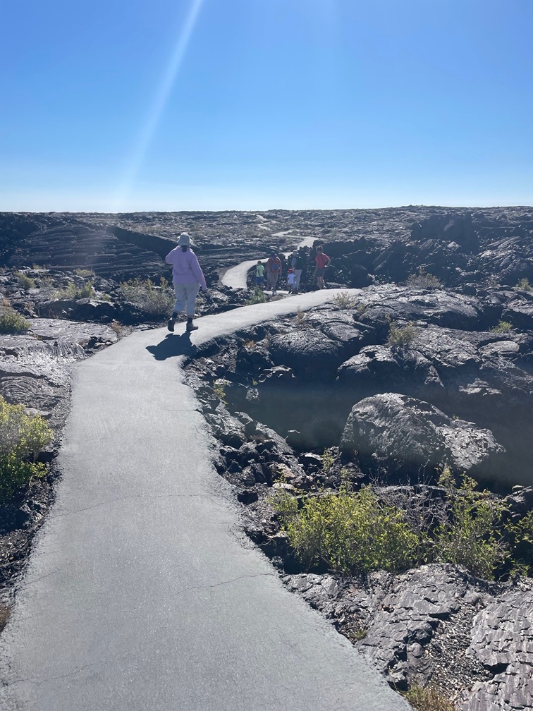
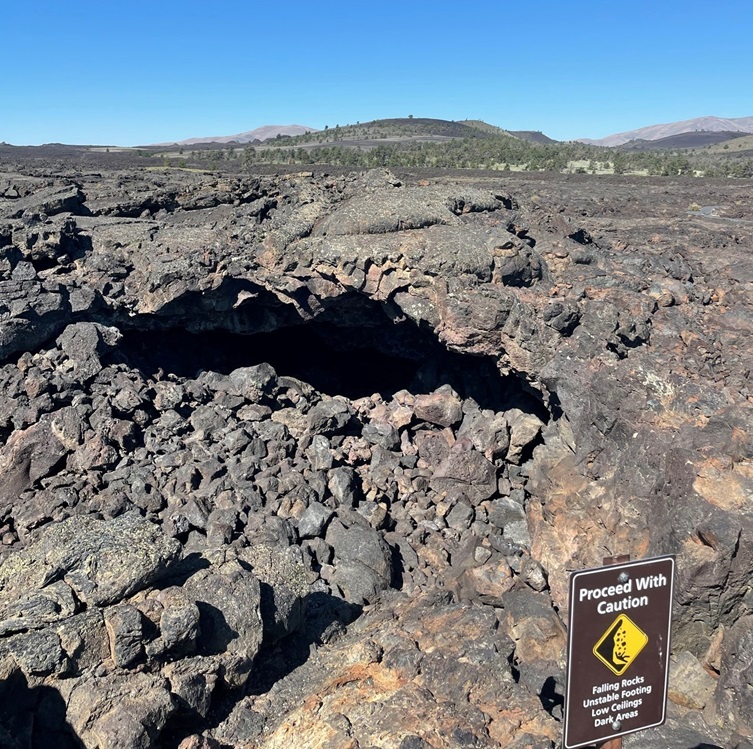
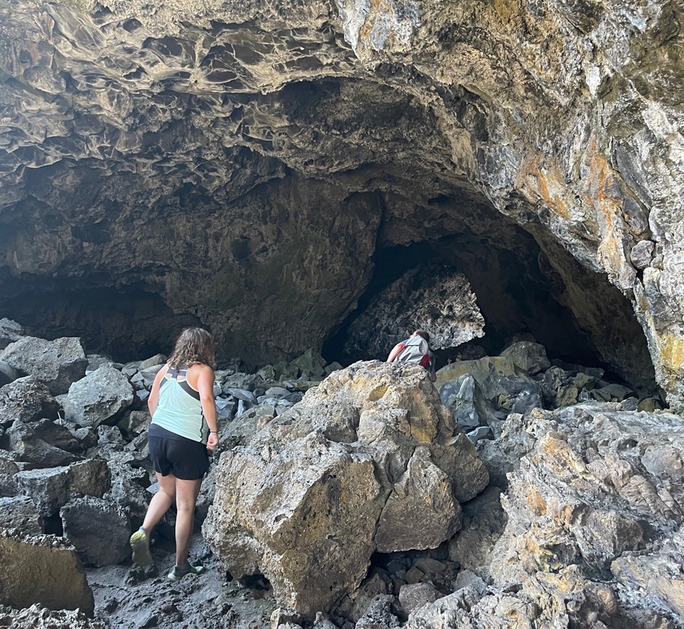
Craters of the Moon National Monument has a lot going for it, and we were fortunate to be able to include it in our summer 2023 itinerary. We saw plenty of other places with lava flows both (relatively) new and old in Idaho – we spent more than two months in the southern and southeastern part of the state – but it was fun to be able to walk across the basalt and wonder what the environment must have looked like when the lava was flowing. Interestingly, the volcanic features at Craters of the Moon are believed to be only dormant – not extinct – and geologists expect the region to become active once again within the next thousand years, and some believe it could be within the coming century.

Petrified Forest National Park, Day 1

Near Holbrook, Arizona – March 25, 2022

Progressing east and west, Interstate 40 divides Petrified Forest National Park into northern and southern sections. The interstate generally follows the path of historic U.S. Route 66, which connected the midwestern United States to the country’s west coast in the first half of the 20th century. Although Route 66 stretched more than 2,200 miles from Chicago to Los Angeles, Petrified Forest is the only national park with former segments of the historic highway within its boundaries. The area south of the interstate, much larger in size than the northern part, contains most of the petrified wood specimens in the park. The northern area, however, boasts incredible roadside vistas of the Painted Desert and a sizable national wilderness area. Nancy and I visited the northern part of the park in late March. Gunther stayed with Rusty in the Goddard, but Nancy and I would enjoy the dog’s company when we returned to the park the following day.

We briefly stopped in at the northern visitor center, which was undergoing significant renovation at the time, then proceeded to drive along a route that included a number of overlooks of Petrified Forest National Park.

I decided to use my 14mm wide-angle lens for taking pictures the day we visited the Painted Desert. I got it a couple of years ago to primarily take pictures of the night sky but thought its properties would help capture the feeling of the vast open landscapes of Petrified Forest National Park. There is a disadvantage to using this lens, though: it’s not automatic, so the aperture, ISO, and other settings all must be set manually. I’m no good at any of that. Many of the photos I took were over- or under-exposed, and I had to make manual adjustments using a couple of pieces of photo editing software.

One gets a different perspective of time and distance when visiting this part of Petrified Forest National Park. The different colors in the gullies in the center of the photograph represent 200 million years of sediment being laid down by rivers and then being eroded by later rivers, and the rock formation on the horizon at left, Pilot Rock, is nearly seven miles away. The horizon in the center is much further – perhaps a hundred miles.
This view of a deep basin formed from erosion is from one of the first overlooks on a road that goes through the Painted Desert. One can see for, literally, a hundred miles to the horizon. They’re not visible in this photo, but we could see many, many tractor-trailers traversing Interstate 40 on the other side of this huge basin. Sharp-eyed viewers will, however, note a distinct lack of petrified wood in this view; that’s because most of the petrified logs are well south of this part of the park.

Petrified Forest National Park contains only a small part of the Painted Desert, which stretches across almost 8,000 square miles of northeastern Arizona. The colorful rocks, primarily mudstone and sandstone, of this region are called the Chinle Formation. Deposited from 227 to 205 million years ago during the Late Triassic Period while most of the land area on Earth was on the single supercontinent Pangaea, the rocks have been buried, lifted, and eroded during Pangaea’s breakup and shift into today’s major continents.

There are still living trees to be found in Petrified Forest National Park, but they’re nothing like the towering conifers that grew 200 million years ago when the area was located at about present-day Costa Rica. The park’s overlooks are built on a layer of basaltic rock that was ejected from volcanic eruptions only between 16 and five million years ago, forming a protective layer that is much more resistant to erosion than the sedimentary layers of rock below.

During the Late Triassic Period, the land comprising Arizona’s Petrified Forest National Park was located just north of the equator and supported a much different environment (different enough, for example, to support a forest of 180-foot-tall trees that would later become petrified). As Pangaea divided, the land mass migrated north and the land itself underwent massive changes.

The different colors seen in the Painted Desert are quite impressive. Large river systems flowed through this area hundreds of millions of years ago, depositing many layers of gravel, silt, and sand. The different colors of the layers are created by varying mineral content of the soils, which have been exposed through geologic movement as well as water and wind erosion.

The Chinle Formation is itself divided into five members: Mesa Redondo, Blue Mesa, Sonsela, Petrified Forest, and Owl Rock. Each member represents a transition of the land from wet to dry environments over millions of years: the Mesa Redondo, the oldest layer and therefore the one underlying the rest of the formation, consists of red sandstone originally laid down 226 million years ago, and the youngest, Owl Rock, includes pink and orange mudstone at the top of the formation that was deposited 207 million years ago.

Here we see a visitor to Petrified Forest National Park (it’s Nancy) contemplate more than 200 million years of geologic change that resulted in these magnificent views.

Older rock formations in the Painted Desert are at the bottom of the geologic column, and the layers of rock grow younger in age as the elevation increases. The colors of these rocks come from the iron they contain. Drier climates allow the minerals to become exposed to oxygen, causing the iron to rust and develop distinctive red, brown, and orange colors. When the climate is wet, moisture essentially covers the sediments and prevents their oxidation. Those layers are colored blue, gray, and purple.

I think a lot of people might underestimate just how wide-open the American West can be. This picture, taken from the Pintado Point overlook at the national park, gives an idea of how far one can see in the northern Arizona desert. For instance, Turkey Track Butte is nearly 23 miles away from this viewpoint but is still distinctly visible. Behind the butte, the San Francisco Peaks are barely discernable, but they’re more than a hundred miles away. Pilot Rock is the highest point in the park, and Lithodendren Wash is a seasonal stream.

Nancy and I took a short hike along the rim of the basin, and one of the highlights of that walk was a stop at the Painted Desert Inn, which was originally built as a respite for travelers on Route 66. The highway passed just a short distance south of the building, and a spur road brought visitors to the inn for refreshments.

Records are unclear regarding exactly when the building was first constructed, but descendants of the original owner say he built it in the late teens of the 20th century. The Painted Desert Inn had several owners during the course of its life as a place of rest for Route 66 travelers, but the U.S. government bought the building and four surrounding square miles of land in 1936. Petrified Forest National Monument had been established 30 years earlier, and the area became a national park in 1962.

The interior of the Painted Desert Inn now serves as a visitor center for the Painted Desert as well as a museum with artifacts from the inn’s heyday. It’s all very impressive and you’re going to have to take my word on that because none of the pictures I took inside turned out.

Despite my photographic foibles, we really enjoyed this first visit to Petrified Forest National Park. I grew up on the eastern plains of Colorado, and I know long, uninterrupted distances. They are nothing compared to what can be seen in northeastern Arizona.

We’d see more of the park, and a little bit of actual fossilized wood, the next day. (Actually, we’d see a lot of fossilized wood. So. Much. Fossilized. Wood.)

Website Built with WordPress.com.

Up ↑