About 190 million years ago, much of the present-day southwestern United States was covered in an immense field of sand dunes – one of the largest that has ever existed on the planet. Many of the dunes happened to carry iron pigment, which turned red when it was oxidized by the sun.
Over the course of millions of years, and with the help of chemical compounds like calcium carbonate and iron oxide, the dunes were slowly cemented into a rock called Aztec sandstone.
These sandstone formations are the primary feature of Red Rock Canyon National Conservation Area, located only about 15 miles west of the casinos, hotels, nightclubs and other delightful debauchery of Las Vegas, Nevada. The area includes nearly 200,000 acres (about 300 square miles) of the Mohave Desert, and it’s visited by 3 million people each year – a little less than what Yellowstone National Park in Wyoming receives.
It’s an impressive number of visitors, to be sure. I think, however, that most of Red Rock Canyon’s visitors are from the Las Vegas area. Its canyons and sandstone cliffs make it remarkably unlike most of the rest of the flat desert surrounding the city, and it’s extremely popular with hikers, cyclists, and rock climbers. Consider that Las Vegas’s Harry Reid International Airport (until 2021 McCarran International Airport) saw almost 58 million passengers arrive and depart in 2023, and it’s easy to see that most of those people aren’t coming to The Entertainment Capital of the World to entertain themselves by visiting a national conservation area.
Being avid hikers with interests in geology and biology, Nancy and I (and Gunther) went to Red Rock Canyon National Conservation Area in early December 2023. We were happy to be joined by a Canadian couple we met at the campground in Las Vegas at which we were staying; it turns out that Canadians enjoy hiking as well. They also joined us for a visit to the Hoover Dam, a hike in Lake Mead National Recreation Area, and a hike in Valley of Fire State Park north of Las Vegas (not all on the same day).
A one-way scenic drive, a loop 13 miles in length, at Red Rock Canyon provides many pullouts and parking lots with access to hiking trailheads (beginning a total of 22 trails ranging in length from under one mile to more than 10 miles), overlooks, and other points of interest.
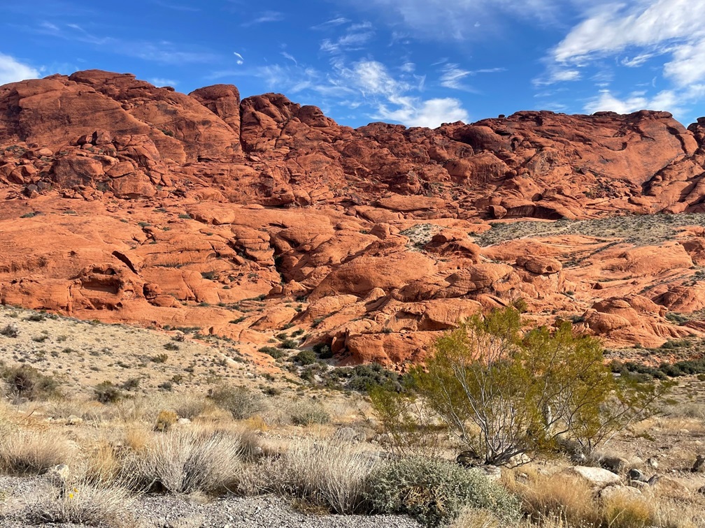
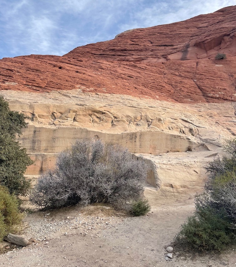
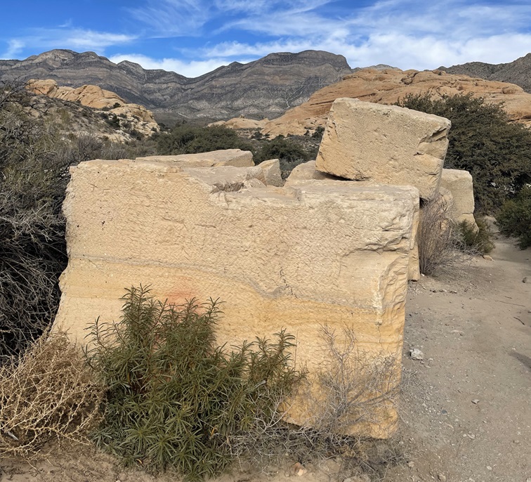
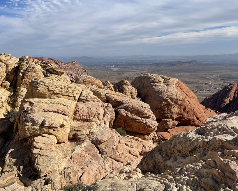
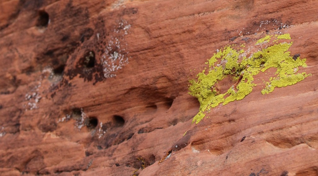
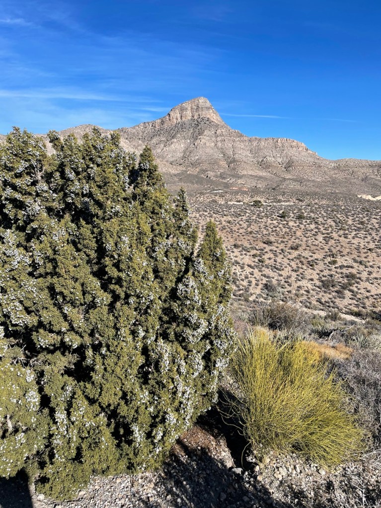
It’s easy to see how Red Rock Canyon got its name. The sand originally forming the dunes contained an abundance of minerals, one of which was iron that was oxidized by the elements over millions of years. The area began its federal protection in 1967, when the Bureau of Land Management (BLM) designated 10,000 acres as the Red Rock Recreation Lands. Further legislation over the years and significant additions of acreage eventually led to the National Conservation Area designation in 1990.I was struck by the clear delineation of colors in the rock. These two different colors of rock are both types of sandstone, but water moving through the sand at the bottom millions of years ago took away the red minerals and left behind calcium carbonate. The sand later developed, over even more millions of years, into sandstone.Erosional forces like water and wind result in some really cool-looking rock formations. Note, also, that the light-colored and red layers of rocks are the reverse of the photo above (and I didn’t post it upside-down).These huge sandstone blocks are not naturally formed: they’re remnants of one of the earliest industries in the Las Vegas area. The Excelsior Stone Quarry began operations in 1905, extracting blocks of sandstone for use as building materials. The blocks, some weighing up to 10 tons, were pulled with a 17-ton steam-traction engine to the just-built railroad in Las Vegas and loaded onto railroad cars bound for Los Angeles and San Francisco, where they served as decorative building material. While the sandstone was judged to be of exceptionally fine quality, quarries closer to California’s coastal cities were later developed and the Excelsior Stone Quarry and other operations in the area shut down for good in 1912. The plant growing in front of the large block is a species of yerba santa, which is Spanish for “sacred herb.” The name comes from the plant’s medicinal properties to treat respiratory and digestive ailments – even today, yerba santa extracts can be found in western U.S. herbal medicine stores.Part of the day included a hike on the Calico Tanks Trail. The long views and beautiful multicolored rock formations along the trail reminded Nancy and me of several places in Colorado, including Garden of the Gods in Colorado Springs and the Red Rocks Amphitheater near Morrison. Two hikers can be seen in the lower-left corner of this image. The BLM has classified the Calico Tanks Trail as “moderate”; I’d say, based on the elevation gain and necessity to scramble up and over rocks, it’s on the far end of “moderate.” It was a beautiful hike, though.These curves in the sandstone were created while the materials were still in the form of loose sand. Wind blowing across the dunes created these lifted layers before the grains of sand were cemented into the sandstone of today.This specimen of Spanish dagger (Yucca schidigera, also known as Mohave yucca) reminded us that we were in the desert. It, like many plants found in the Mohave and other deserts, looks pretty savage.Speaking of savage, Gunther takes a break on the Calico Tanks Trail to enjoy the scenery. He got along really well with the Canadians; he gets along really well with pretty much everyone, no matter their country of origin.This is the feature for which Calico Tanks Trail gets its name: a seasonal pond, or tank, created by water seeping or flowing into a depression in the sandstone (there was a much smaller water feature earlier in the trail, thus the plurality of the trail’s name). The Spanish word for this formation is “tinaja,” which means “clay pot.” The sun on this early December day was pretty low in the sky, making for some considerable shadows from the rock formations. Those of you who have been to Las Vegas will probably think this tank is the third-largest standing body of water in the area after Lake Mead and the fountains in front of the Bellagio resort on the Las Vegas Strip; I would not disagree with that assessment. Formations like this make possible a huge diversity of plant and animal life that otherwise couldn’t survive in the desert.If you squint, the hotels and casinos of Las Vegas can just barely be made out near the horizon in this image, taken at the end of the Calico Tanks Trail. This vantage point took some rock scrambling to get to; along with my phone, with which I took this and most of the rest of the photos in this posting, I was also carrying my digital camera with a large and heavy zoom lens in case we saw any wildlife. A fellow hiker noticed the camera and said I was brave for bringing it along; I corrected him and said I was dumb.So that I didn’t bring my heavy camera lens on the Calico Tanks Trail for naught, here’s a picture of a rock climber I took with it. Rock climbing is a pastime in which I have absolutely no interest in participating.Yeah, this looks like just heaps of fun. The BLM’s website states that rock climbing at the national conservation area is among the best in the world. Red Rock Canyon National Conservation Area is one of more than 850 areas managed by the BLM’s National Landscape Conservation System, which totals 27 million acres of areas designated as National Conservation Areas, National Monuments, Wilderness Areas, Wilderness Study Areas, Wild and Scenic Rivers, and National Historic and Scenic Trails.Longtime readers of this blog know that I won’t pass up an opportunity to post an image of lichen. I have no idea what species this is, but I think the shade of green is best described as “obscene.” Together with wind and moisture, plants and lichens do their part to erode the rocks into all kinds of fantastic formations.This is a view from High Point Overlook (elev. 4,771 feet) looking east toward the city of Las Vegas, which is 15 miles on the other side of the rock formation. High Point Overlook is just a little shy of the midway point of Red Rock Canyon’s scenic drive. The vegetation in the foreground gives an idea of what the flat parts of the area are like; it appears kind of sparse, but it’s much more heavily vegetated than other areas we’ve seen around Las Vegas. There are about 600 species of plants found in the conservation area, a number boosted considerably by the presence of year-round water: the sandstone allows water to percolate, creating springs, pools of standing water like the Calico Tanks, and even small creeks and waterfalls .This is Turtlehead Peak (elev. 6.323 feet), also photographed from High Point Overlook. There’s a trail to the top, but it’s 5 miles round-trip with a 2,000-foot elevation gain, and Gunther didn’t want to try it so we didn’t. That’s a heavily laden Utah juniper (Juniperus osteosperma) on the left, with Mormon tea (Ephedra nevadensis) growing at its base.I wasn’t planning to see any natural bodies of water in Red Rock Canyon National Conservation Area, let alone one that was flowing. This is Lost Creek, along which we saw a huge diversity of plant life flourishing in early December. I will remember this very short hike off the scenic loop for a couple of reasons: this stream, and the fact that Nancy bonked her head on a low-hanging ponderosa pine branch that was overhanging the trail; she didn’t see it because of her hat brim. If she hadn’t been in the lead of our hiking party, any of the other three of us would probably have bonked our heads (even though he was ahead of Nancy, Gunther didn’t bonk his head because he’s an expert hiker. And he was able to just walk under the branch, without making note of the obstruction to Nancy.) We’ve discovered that the maintenance of trails in the federal system can vary greatly; BLM trails are perhaps the most … rustic. It’s really not a problem, and I’m certainly not complaining. It’s just interesting to see.Here’s an example of the diversity of plant life in Red Rock Canyon National Conservation Area: a specimen of ashy silktassel (Garrya flavescens), growing along Lost Creek. I’ve never knowingly seen it before. It can grow up to about 10 feet high. Another short trail from the scenic loop leads to a grouping of petroglyphs and pictographs, created by native Americans thousands of years ago. The minerals in rock exposed to the intense desert sun over the millennia develop a dark patina called desert varnish. The native Americans removed the patina with stone tools to expose the lighter colors of the original rock beneath, creating designs known as petroglyphs. Pictographs, in contrast, are designs created with paints made with clays, charcoal, and other minerals, and then applied to the rocks.Here’s a closer view of the petroglyphs in the photo above this one. The meanings or significance of these designs have been lost to time; the only communicative records of the people who created these designs that still exist are the petroglyphs themselves. Nancy and I have seen quite a few petroglyphs in New Mexico and Arizona, but it was a bit surreal to see these ancient designs just 15 miles from the (barely) controlled 24-hour party of the Las Vegas Strip.Here’s an example of a pictograph, or an image painted on the rock, located just a few yards away from the petroglyphs. It’s a little hard to see in this photo, but petroglyphs and pictographs are themselves sometimes hard to see in the wild. There’s a closer view of the pictograph below.The pictograph looks like a figure 8 with a vertical line inscribed through it (it’s just to the right of dead center in the photograph above). Again, we have no idea what its significance is, but it must have been important to someone a very long time ago. The BLM and other federal agencies take great care to protect these cultural artifacts; like in other areas around the country, the precise locations of many of the pictographs and petroglyphs in Red Rock Canyon are not made available to the public. Six major groups of native Americans have lived in what is now Red Rock Canyon, beginning with the Tule Springs Paleo-Indian culture 11,000 to 8,000 years ago.
A visit to Red Rock Canyon National Conservation Area had been highly recommended by one of our Lyft drivers who happened to be a native of Las Vegas, and she was right to do so. I mean, we would have gone regardless, but our visit definitely blew past what I thought it would be like. I sure wasn’t expecting to see those incredible views, enjoy fascinatingly colorful rock formations, and go on a hike next to a running stream, let alone appreciate imagery left by native Americans thousands upon thousands of years ago, but Red Rock Canyon had all of that and more. If you do find yourself in the Entertainment Capital of the World and want to experience something completely unlike what Las Vegas is known for, Red Rock Canyon National Conservation Area is a wonderful place to spend a day.