Homolovi State Park, near Winslow, Arizona April 16, 2025
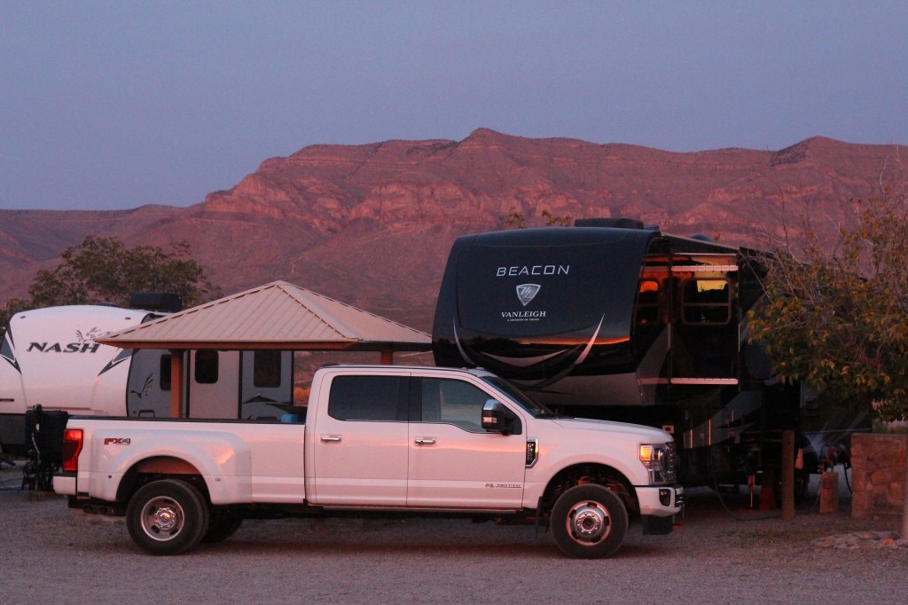
We’re camping for two weeks in Homolovi State Park, just a couple miles east of the town of Winslow, Arizona (pop. 9,005; perhaps you’ve heard of it – one of its street corners is mentioned in the Eagles’ first major hit from 1972, “Take It Easy”). This is our third time staying here in three years – we really enjoy it. After spending five months wintering in Las Vegas, Nevada, and then a couple of campgrounds on Interstate 40 in Arizona, we’re appreciating the quiet environment and dark skies of this state park (not that we didn’t have a good time in Las Vegas; in fact, we’ve reservations to be back there beginning this November).
The main feature of this state park is a cluster of four major ancient Native American villages, several miles apart and all built and occupied around the years 1290-1400. The villages were then abandoned, but it’s generally understood that the people who lived here eventually became what is now the Hopi nation – one of the tribe’s reservations is about 60 miles north of present-day Homolovi State Park. The four villages are designated Homol’ovi I-IV; the name of the state park doesn’t include the apostrophe of the village names. “Homol’ovi,” in Hopi, translates to “place of the little hills,” and the Hopi also refer to the city of Winslow as “Homol’ovi.”
The Hopi call the people who lived here – most likely their ancestors – the Hisatsinom, which means “the people of long ago.” During the period in which the Hisatsinom lived in this region, they built and occupied four or five large villages – some comprising hundreds of rooms – using rocks gathered from the ground.
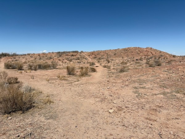
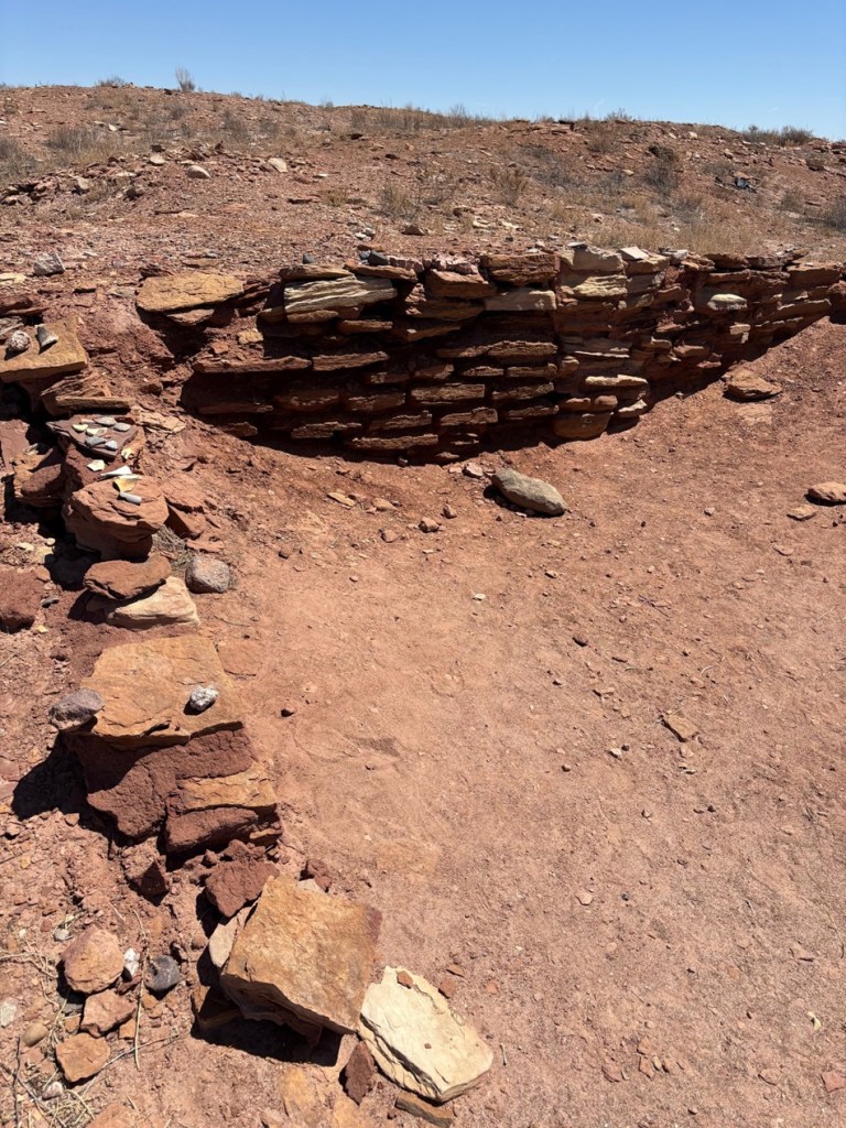
The Little Colorado River, a watercourse that drains the Painted Desert area of northeastern Arizona, flows through Homolovi State Park. I took this photo while Nancy and I were driving to Winslow; the perspective is looking north from a bridge on the former U.S. Route 66 (and now Arizona State Highway 87). The trucks and trailers just on this side of the horizon are on Interstate 40. The Little Colorado River’s headwaters are in the mid-eastern region of Arizona, very near the state’s border with New Mexico. It then flows almost 340 miles in a northwestern direction until it empties into the Colorado River in the Grand Canyon. The river flows from its headwaters all the way to the Grand Canyon only during periods of flash flooding or heavy snowmelt; much of the year it’s a braided and puddled wash. I took this photo the day after the area got some appreciable rain and snow, and the water level rose only marginally. The occasional flash flooding of the Little Colorado River, which swept away crops and structures, is probably why the Homol’ovi sites were abandoned in favor of the area further to the north and which the Hopi call home today.This is the site of a major native American village, known now as Homol’ovi I, that was last occupied about 600 years ago. At its peak, it contained about 1,100 different rooms constructed of rocks. Some of the rooms included three stories. Over the ensuing six centuries, a lot has happened to destroy these unoccupied villages. Dependable northern Arizona winds have covered the village with dirt and sand, but some structures, such as the one on the mound at the right, can still be discerned. Many of the rocks in the structures were taken by members of a nearby Mormon community in the late 1800s for use in their own buildings, and vandals have also destroyed the buildings and looted the pottery.
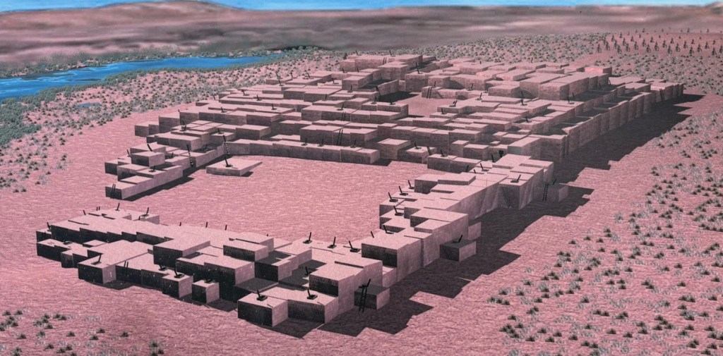
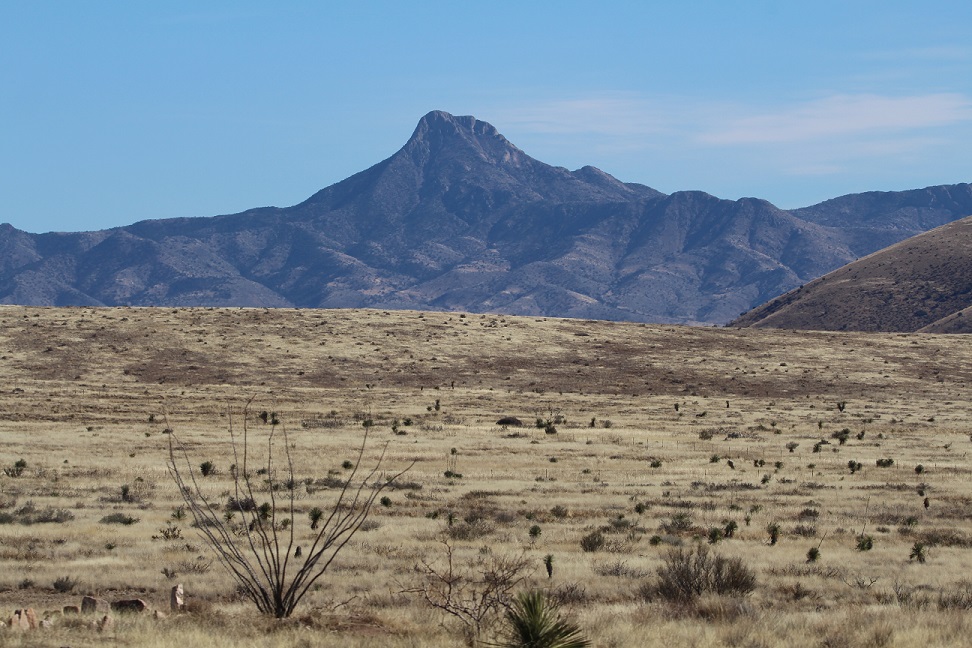
Take a look at the tall plants on the horizon at far left: directly to the right of them, you’ll see some white splotches (not the clouds, which are further to the right; the smaller white splotches of which I write are immediately to the right of the tall plants). Those are the San Francisco Peaks, still snow-covered in mid-April. The town of Flagstaff, Arizona, is at their feet. Those mountains are about 65 miles west of Homolovi State Park.I took a picture of this image, an artist’s depiction of what Homol’ovi I looked like at its peak, at an information kiosk near the site of the former village. That’s the Little Colorado River in top right. The original image gives credit to Douglas Gann of the Center for Desert Archaeology.
From about 1290 to 1360, it’s believed that Homol’ovi I grew from a village of 200 rooms to more than 700. Around the year 1360, the village now known as Homol’ovi II was established about 3 miles, or 5 kilometers, north of Homol’ovi I; that second village quickly became the biggest one in the cluster at 1,200 rooms. Homol’ovi I, however, benefited from the second village’s success, and grew to a maximum of 1,100 rooms.
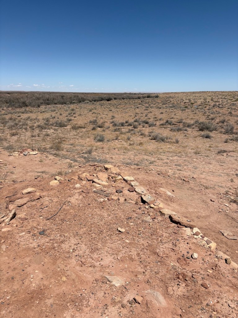
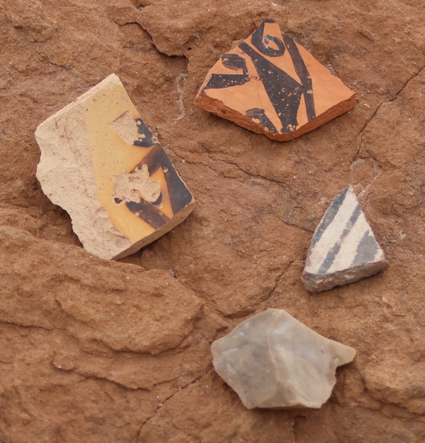
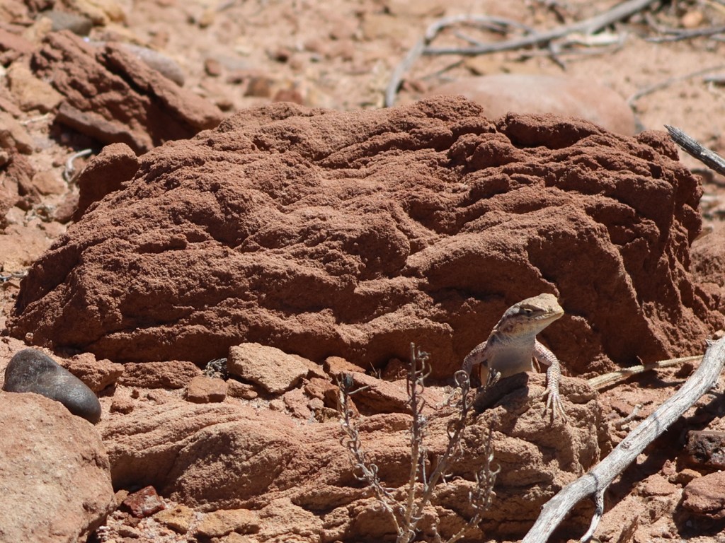
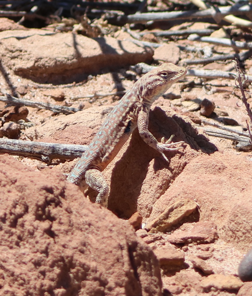
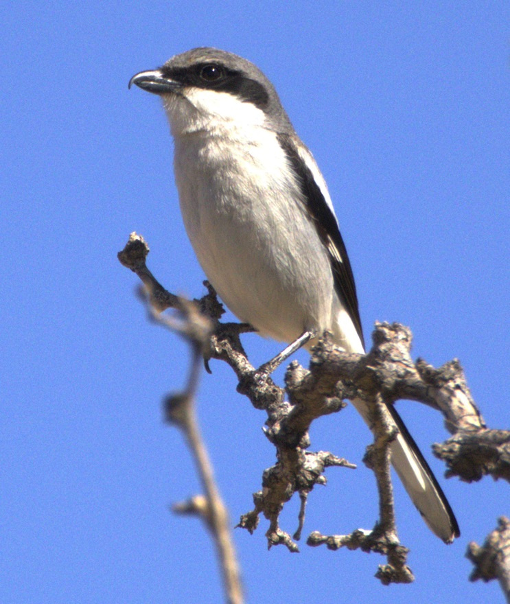
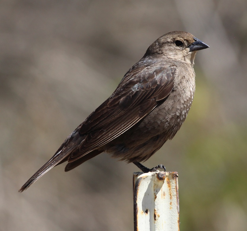
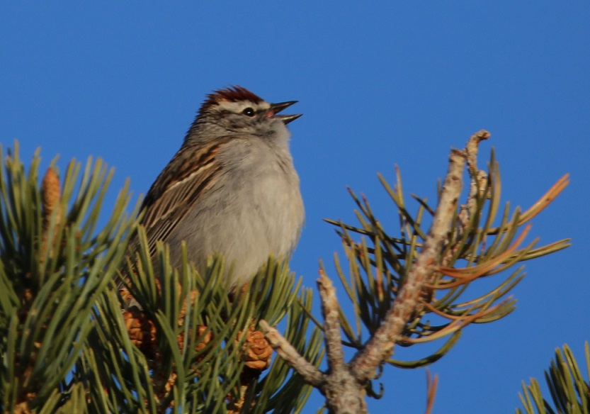
This photograph was taken from the top of the hill shown in the previous photo, still looking to the northwest. The rocks in a line are the former wall of a room. The trees near the horizon are on the east bank of the Little Colorado River; it was that river’s occasional flash flooding that likely led to the abandonment of Homol’ovi I and the other villages 600 years ago.This is a small grouping of pottery shards and what appears to be a hand-shaped rock, taken from the ground at Homol’ovi I and placed on a larger rock. The pieces of pottery are roughly the size of an American half-dollar. There are thousands of shards like these at the site, and most of them are on larger rocks like this. Archeologists and conservationists prefer that people don’t do this; instead, simply leave the shards on the ground.This is the largest exposed wall still standing at Homol’ovi I, and it’s been almost entirely rebuilt by archeologists. Note the small collections of pottery shards on some of the rocks at left: don’t do that.THIS IS A TALES OF THE GODDARD LIZARD ALERT. This little guy (and he is a guy, and I’ll tell you why I know shortly) caught my eye as he scampered across the rocks and sand of Homol’ovi I. He is a side-blotched lizard, a genus (Uta) of which there are now seven species, and he and I were to have kind of a neat interaction. This photo of my new reptile pal shows why the genus is called side-blotched lizard – observe the dark mark (or, in scientific terminology, “blotch”) on its side just behind its front leg. The turquoise-blue dots on the back are also a defining characteristic of the genus. These lizards grow to a length of about six inches, including the tail. Their diet includes insects, spiders, and other arthropods such as the occasional scorpion. They are themselves predated upon by larger lizards and roadrunners.In an attempt to give the reptile some space, I continued walking down the path through Homol’ovi I – but the beast pursued me. Observe the very pretty light-blue dots on its back. I was about six feet from the lizard when I took this photo (using a 400mm telephoto lens).Here’s a cropped version of the previous photo. Behold those beautiful blue dots as well as some detail of its fearsome front claws. After I took the photo, the lizard continued to approach me: in fact, it got to about six inches from my left foot – and then it scampered away. Turns out, that’s a common behavioral trait of male side-blotched lizards. The scientists don’t know if the behavior is intended to scare away possible intruders from its mate, or to defend its territory. At any rate, I got the hint and moved along (even though my course on the path took me in the same general direction of the lizard, who at that point was many yards away). I later described my interaction with the side-blotched lizard to Nancy, who did not at all appreciate when I poked her under her armpit to show her where the blotch on the lizard’s side was. We also shared the same belief that she would have absolutely and completely freaked out if the lizard had gotten to within six inches of her left foot.More wildlife: I always like to include some bird photos in these postings, so here are a couple of images I took in our campground at Homolovi State Park. This is a black-throated sparrow (Amphispiza bilineata), a species found in the southwestern United States and much of Mexico. They are absolutely beautiful little birds. I’ve seen them only here at Homolovi State Park and at Tuzigoot National Monument, further west in Arizona.This is a loggerhead shrike (Lanius ludovicianus), on a tree just a few feet from the Goddard’s campsite. I remember reading about shrikes when I was young, but I didn’t see one in the wild until a couple of years ago at McDowell Mountain Regional Park east of Phoenix, Arizona. I also saw some over this past winter at Clark County Wetlands Park, very close to the campground where we spent the winter near Las Vegas. Loggerhead shrikes are found nearly all over the United States.
We’re planning to join a ranger-led tour of Homol’ovi II, which has been partially excavated and reconstructed, on Saturday, April 26. I’ll write and post photographs from that experience afterwards. We were on the same tour a couple of years ago, but, because of our travels and opportunities to see ancient Native American sites in the southwestern United States since then, we have a better perspective of what we’ll see.
One day – I think it was a Tuesday but I could definitely be wrong – about 35 million years ago, a volcano began erupting in what is now southwestern New Mexico.
Somewhat later, on January 8, 2023, Nancy, Gunther and I visited City of Rocks State Park, located about 20 miles south of the caldera that produced the eruptions. The pumice and other rocks produced by the volcano’s eruptions 35 million years ago form the main feature of the state park, which also has a number of interconnected hiking trails, developed campsites, a botanic garden, and even an astronomical observatory.
We’d planned to visit he park, which is located halfway between Deming and Silver City, New Mexico, just a few miles east of U.S. Route 180, several times in 2021 and 2022 when we were camping in Deming and Silver City. However, the 35 mile-per-hour winds each of those days convinced us to find something else to do. The morning of January 8 was bright and calm, and we made the short trip to the state park. We’re all glad that we did.
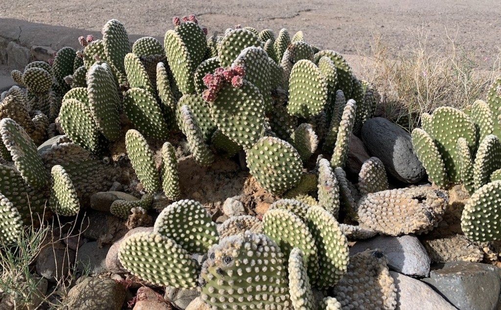
You’ll find plenty of prickly pear cactus at City of Rocks State Park in New Mexico, along with a wide variety of other plants. In the background, a vehicle provides a sense of scale for the namesake rocks near the park’s visitor center.
The park, at an elevation of just over 5,200 feet, gets its name from several tall outcroppings of rock that have eroded over the past 35 million years into pinnacles and other formations, separated by lanes that resemble city streets between tall buildings.
Here we see an amateur geologist, with her professional dog, on one of the park’s trails. They appear to be in disagreement about which direction to proceed. The park has about five miles of trails, some of which wind directly through the rock formations. Many of the pinnacles are 40 feet tall.
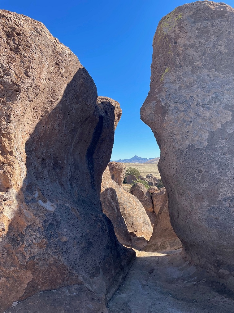
Paths between the rocks can get pretty tight. During the main phase of the volcano’s eruption, more than 240 cubic miles – about twice the volume of Lake Erie – of pumice and ash were ejected. This eruption also resulted in the “Kneeling Nun” formation east of present-day Silver City, 20 miles to the north. The pointed mountain seen between the two rocks is Cookes Peak (elev. 8,408 feet), a significant landmark in southwestern New Mexico. The mountain is directly north of the city of Deming.
The volcanic eruption that formed the formations of City of Rocks likely lasted several years and was about a thousand times larger than the Mt. St. Helens event in Washington on May 18, 1980. The eruption blanketed this area in a deep layer of hot ash and pumice. As those volcanic materials cooled into a rock called tuff, it shrank somewhat and vertical cracks in the stone were created.
They still haven’t agreed on a direction in which to hike. The park has a huge variety of succulents, like the soaptree yucca at the left of the trail, as well as many grasses common to the southwestern United States.
Over the last several tens of millions of years, the erosive forces of nature – water, wind, and organic growth – broadened the small fissures between the rocks into larger and larger crevices until the natural pathways seen today were created.
Now they’re both headed the same direction. The amateur geologist is standing in a crevice that is a conduit for water flowing through the rock formation. It’s that water, which carries abrasives like sand, that helped carve the rocks into the shapes we see today. Other contributors to the erosion include wind, which can also carry sand, as well as plant (and non-plant) life and the cycle of freezing and thawing water.
Many different groups of native Americans have lived in, or at least passed through, the area now known as City of Rocks. About 12,000 years ago, the last of the Ice Age glaciers were retreating and large mammals like mammoths and mastodons roamed this region. It’s likely that Paleoindians, like Clovis or Folsom peoples, hunted the large animals. Between 8,000 and 1,000 years ago, small bands of the Desert Archaic culture lived in the area and, toward then end of that era, began to build pit houses. Finally, the Mimbres culture occupied the area between the years 200 and 1150 AD. In addition to hunting animals and gathering food from plants, the Mimbres cultivated crops like beans, squash, and maize. They also built one-story above-ground dwellings.
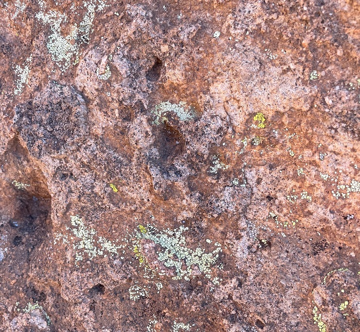
Do you like lichen as much as I’m likin’ this lichen? There are about 20,000 known species of lichen in the world, and at least four of them can be seen in this photograph. Lichen, which is plant-like but not an actual plant, contributes slowly but significantly to the erosion of rocks by chemically degrading the stones’ minerals. The scientists estimate that between 6-8 percent of the earth’s land surface is covered by lichen. Actual plants, like succulents, grasses and shrubs, also contribute to erosion by their seeds finding purchase in small crevices in the rock and then, as the plants mature, the growing roots of the organism can cause further fracturing of the minerals.
Getting up-close and personal with the rocks allows one to see some pretty fascinating natural patterns caused by erosion. I sure hope that whoever dropped those keys comes back by to pick them up! (Just kidding – they’re mine. Still need to go back and pick them up.)
Because the park is 25 miles from the nearest city of any size, it’s a popular site for stargazing at night. This structure is an astronomical observatory located near the main campground in the park. The roof slides back onto the supports in the back to reveal the telescope. It was not in operation during our visit (as you can see, it was daylight), but the park does host regular star parties during which the observatory is open and other amateur astronomers bring their own telescopes to share views of the night skies.
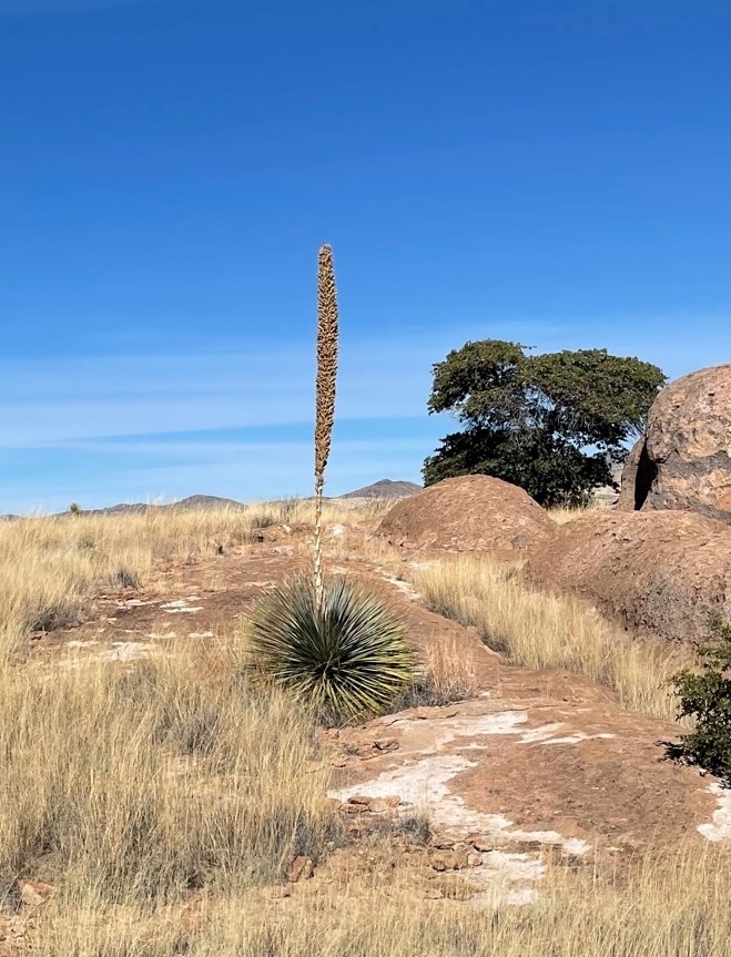
This magnificent succulent specimen, about 20 yards off the trail, is desert spoon (Dasylirion wheeleri). I didn’t want to get off the trail to take a closer picture, so this will have to do. The fronds of desert spoon were used by native Americans to weave baskets and mats, and its inner core can be fermented into an alcoholic drink, similar to tequila, called sotol. It is found in southern New Mexico and Arizona, as well as parts of Texas and Mexico. The plants themselves grow to about 5 feet tall, but the flowering spike can soar 16 feet into the air.
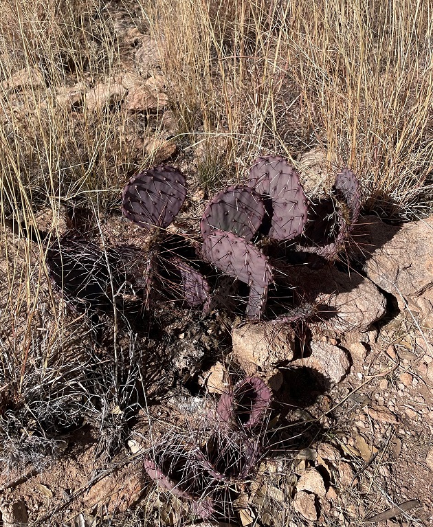
Here’s another interesting succulent found along the trail. This long-spined, purplish prickly pear is called long-spined purplish prickly pear (really) (Opuntia macrocentra). It, too, is found in Arizona, New Mexico and Texas, along with Mexico. Like other prickly pears, the fruit of this cactus is edible and is enjoyed by animals and humans alike.
But it wasn’t simply succulents we saw – we also spied several species of sparrows! Here’s a chipping sparrow (Spizella passerina) perched in some mesquite. We’ve enjoyed seeing plenty of these pretty little birds in southern New Mexico this winter.
While most of the pictures in this posting were taken with the camera on my phone, I used my digital camera to take this photo of Cookes Peak. The tall spindly shrub in the lower left corner is ocotillo (Fouquieria splendens), which can grow to more than 30 feet in height. It is native to the Chihuahuan and Sonoran deserts in the United States and Mexico. Native Americans used different parts of the plant to address a variety of ailments, and ocotillo can also be planted to serve as a natural fence.
A short spur off the main trail took us to the top of a 300-foot hill that provided a tremendous 360-degree view of the area. In this photo, the rock formations of City of Rocks are in the midground (the white streaks above the center of the photograph are campers’ recreational vehicles parked amongst the rocks, and the light brown building to the left of the RVs is the park’s visitor center). The tallest mountains on the left horizon are the Cobre Mountains, 16 miles away, and the Pinos Altos range, 30 miles in the distance, is just to the right of the Cobre Mountains.
This eye-catching grass is cane bluestem (Bothriochloa barbinodis), a valuable forage for ranchers but one of the first grasses to disappear if a pasture is overgrazed. The seed heads catch the sun in such a way as to look absolutely illuminated from within.
When we walk by a creosote bush (lower left), I like to rub my fingers on the leaves – they smell just like the air outside after a rainstorm. Along with seemingly every other plant, Native Americans found many medicinal uses for creosote. In the background is Table Mountain, the tallest point in City of Rocks State Park. The distinct layers of rock seen on the mountain’s slopes are due to different volcanic ashflows more than 30 million years ago..
If you plan to visit City of Rocks State Park, you’ll want to do make plans to do so soon-ish. The erosional forces that created the cracks between the rocks continue to degrade the stones even today (I mean, you saw all the lichen), and in several million years the whole area will just be flat.
Nancy and I definitely enjoyed our time in the park – it was a lovely day, with highs in the low 60s and very calm breezes, and the 4-mile hike gave all of us some great views and good exercise (Monday, January 9, was a day of relaxation and recuperation for Gunther). We plan to take the Goddard to the park in the next few years for some actual camping – it has more than 40 developed sites – and it has some other trails that we haven’t yet enjoyed.
St. Vrain State Park had its beginnings in 1958 when the Colorado Department of Transportation bought some land around St. Vrain Creek to mine gravel needed for the construction of highways in the area. The mining projects left wide but relatively shallow holes in the ground, many of which filled in from the low water table of the St. Vrain. Over the years, more mining companies extracted more gravel, and now St. Vrain State Park has eight ponds and reservoirs, along with 87 campsites in eight different campgrounds. The state park is a popular destination for campers along Colorado’s Front Range; it’s just an hour’s drive from our former house in Denver. We camped there in our former trailer every April for a decade before becoming full-time RVers, and we returned to the shores of St. Vrain State Park in early May 2022.
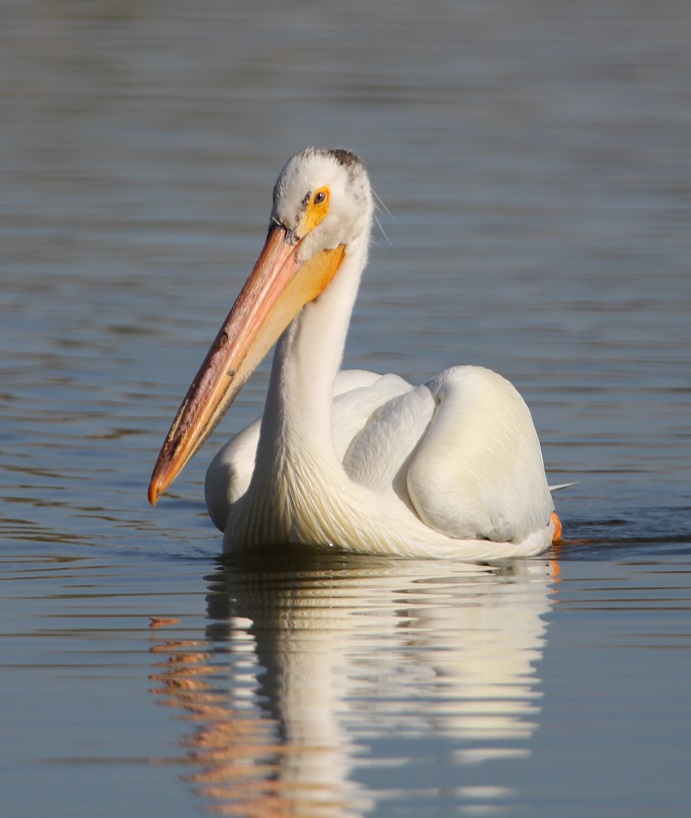
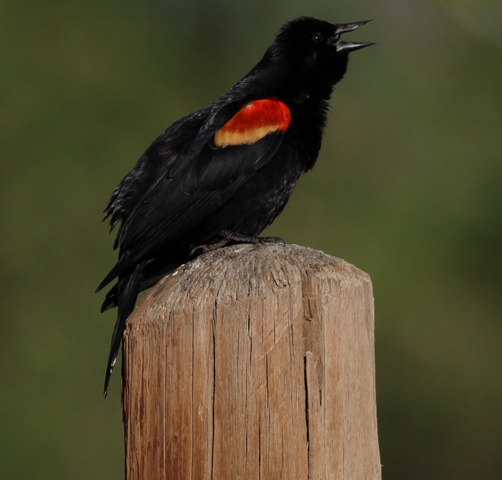
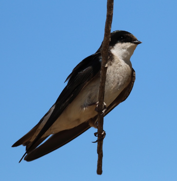
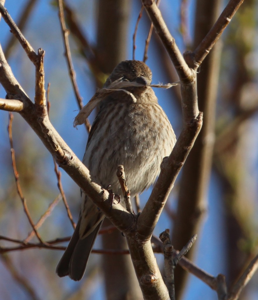
St. Vrain State Park is a bird enthusiast’s dream destination. The park’s literature lists more than 200 bird species that can be seen in the park’s ponds, wetlands and meadows. Not all of those species are in the park at once; many use the ponds as a migratory rest area on their way to points north or south of Colorado, and others stay in the park for a few weeks or months out of the year. We saw more American white pelicans in the park in 2022 than we had in previous years. Watching them float noiselessly on the surface of the water is a very relaxing experience. When we were camping along the west bank of the Mississippi River in Arkansas a few weeks later, a flock of about 200 pelicans darkened the sky as the birds flew overhead.St. Vrain State Park is the largest great blue heron rookery in Colorado. Great blue herons are relatively common sights along the banks of the larger ponds in the park; they usually fly off if approached. If one is patiently quiet and still, however, it’s possible to see a heron catch a fish in the shallows. The largest of the heron family, great blue herons can grow to 4 1/2 feet tall and weigh more than five pounds, with a wingspan of 6 1/2 feet. I photographed this one on an early foggy morning on the bank of Sandpiper Pond. Whenever I think of St. Vrain State Park, the first bird that comes to mind is the red-winged blackbird. Their distinctive call (you can hear it at the soundfile below) can be heard throughout the park practically all day long, but especially in the early morning hours. While I’ve seen red-winged blackbirds perch on waving reeds and cattail stalks, in addition to tree limbs, this one found a solid fencepost upon which to belt out the hits. This is a bird species in which the males and females look nothing alike. This is a male blackbird; I’ve mistaken female blackbirds for some type of sparrow because they share the same light and dark brown markings.We were happy that our friends Mary and Robert, and their German shepherd, Otis, could camp at the site next to us on one of the weekends we were at the park. Mary, Robert, Otis and I took a walk one morning around Blue Heron Reservoir, the largest and newest of the lakes at the park, and happened to spot this guy out in the water. This photo of a western grebe isn’t great – it was 50 yards out and drifting further away – but it’s an interesting bird. They dive underwater to catch fish, which is their main diet, and it’s kind of fun to guess where they’ll pop up to surface. One of five grebe species that visits St. Vrain State Park, I’d also seen this species at Lathrop State Park near Walsenburg in October 2021.This well-camouflaged little bird is a song sparrow (I’m pretty sure; there are many varieties of sparrows and most of them look at least a little alike). It was hunting for bugs one evening along the banks of Mallard Pond. Click the link below to see why they got their name.Nancy and Gunther and I went on a longer hike one Saturday morning and saw a pair of tree swallows feeding their young nestlings inside a tree cavity. This is the female of the pair, who was hanging out on a tree limb and watching her mate feed their kids in the tree. She’s got just a hint of iridescent blue coloring on her head, whereas the male tree swallow is mostly blue. Like other swallows, their diet is mostly bugs that they catch while flying in the air; unlike other swallows, they also eat berries which allows them to make it through winter much easier.I took this photo of a female brown-headed cowbird a few minutes’ walk down the trail from the swallows’ nest. Cowbirds used to follow bison herds in the American West and forage on insects that were kicked up by the animals’ hooves. These days, they do the same with cattle herds and they’re found from coast to coast. This species has a fairly poor reputation among bird enthusiasts: it doesn’t build a nest in which to lay its eggs but instead lays its eggs in the nests of other bird species. This parasitism, which is practiced by only a few other birds, results in reduced numbers of other songbird species. I’ll be the first to state that this is a terrible, terrible photo. However, there is a story behind it: a little while after taking the photo of the brown-headed cowbird, we looked up and saw what we thought was a flock of Canada geese flying overhead. I took a picture of part of the flock, and I really don’t know why. After our hike, I looked at the photo on my laptop’s screen and realized that those weren’t Canada geese. Look at the beaks of the birds (they’re flying toward the right side of the photo): they’re very long and slightly curved. I thought they might be ibis (ibises?), and I looked at the park’s literature to see if ibis were ever sighted in the park. Turns out white-faced ibis do indeed migrate through St. Vrain State Park! Here’s a link to an Audubon Society page so you can see what these beautiful birds really look like.I know some readers of this blog frequently drive on I-25 between the Denver metro area and the northern reaches of the state. This is what’s beneath the bridges just north of Exit 240: thousands upon thousands (not kidding) of cliff swallow nests (those brownish smudges are the cliff swallows returning to feed their nestlings; I couldn’t get any decent photos of the birds themselves because they move so fast). The swallows have built the nests here to take advantage of the great biomass (bugs) available at the ponds and lakes of St. Vrain State Park. It’s important, I think, to remember just what a huge service that bug-eating birds do for us: imagine how many more grasshoppers, caddisflies, and mosquitoes we’d have to deal with were it not for these feathered friends of ours. The hike that Nancy and Gunther and I went on was chock-full of nifty birds we hadn’t seen before. I had no idea what this was when I took the photo, but I could tell it wasn’t a seagull. Again, after returning to the Goddard, I looked it up. It’s a Forster’s tern (might be another species, the common tern, but Forster’s terns are, inexplicably, more common than common terns). This was an incredibly acrobatic and fast flyer, and much fun to watch during its migratory stopover at the park.I took this photo of a beautiful barn swallow on the same morning that I took the photo of the great blue heron. The lighting, because of the fog, wasn’t great, but I was happy to see this little fellow light for a few minutes on a stretch of fence. Swallows of all kinds are very aerobatic flyers – they dip and whirl about while chasing bugs over bodies of water. We would see yet another species of swallow, the northern rough-winged, while camping on the Mississippi River in mid-June. There are six species of swallows, including the northern rough-winged, that visit St. Vrain State Park either on a seasonal or migratory basis. Over the years I’ve probably taken a hundred photos of double-crested cormorants, but they’ve all been taken when the birds are too far away from shore to turn out very well. They seem to like the company of pelicans while swimming (or perhaps they’re opportunistic feeders taking advantage of the schools of fish found by pelicans), but they’re much more timid than the big white birds and stay further from shore. They also take flight well before the pelicans do. The stars aligned during our trip to St. Vrain State Park in May, and I finally got some photos that aren’t embarrassing to share. During our stop I also figured out why these birds look so odd while swimming: unlike pelicans, or ducks, or geese, or pretty much any other waterfowl, they keep most of their bodies submerged. I think cormorants are one of the greatest visual reminders that, in a way, dinosaurs still walk the earth. This guy would not look out of place as an extra in a Jurassic Park movie.I’ll close with one of the best photos I’ve taken in a good long while. St. Vrain State Park is home to several pairs of nesting ospreys, which return to the same nest year after year, and the number appears to be growing. I noticed a new osprey nest (really not that impressive; it looks like a pile of trash and twigs because that’s what it is) along the road leading into the park, and asked a ranger about it. Turns out that the nest had delayed construction of a section of a long-planned hiking and biking trail that winds its way along the I-25 corridor, at least until the osprey fledglings had left the nest. True enough, work on the trail appeared to recommence a few days before we left, so I guess the fledglings had left home. Anyway, this osprey pictured was perched above Mallard Pond one late afternoon when the sun happened to be shining for a few minutes during an otherwise overcast day. It’s obviously used to passersby, but it’s a beautiful raptor nonetheless. The ponds and lakes have plenty of fish for both anglers and birds, like pelicans, and terns, and grebes, and cormorants. It’s fun to watch a grebe pop out of the water with a fish in its beak, but watching an osprey slam into a lake, talons outstretched, and then lift away with a trout in its grasp is a fantastic experience.
In the two weeks we were at St. Vrain State Park, we saw 26 different species of birds, including five, like the tern and ibis, I’d never seen before at all. We don’t have immediate plans to return to the park, but I don’t doubt that we will go back sooner or later. It’s a great place to unwind, and, although it’s close to I-25, it provides plenty of opportunities to get to know a tremendous variety of our feathered friends.
The Goddard spent the fall and winter of 2021-2022 in New Mexico and then Arizona, and in the spring we headed back north to visit Colorado for a while. Spring is a great time to watch birds: they’re very active as they gather material for nests and later find food for their fledglings. Leaves on trees also begin to emerge as the weather warms up, which I was to discover makes photographing birds much more difficult than in the fall and winter.
Here are some birds we saw doing their spring thing in Arizona, New Mexico, and Colorado.
Holbrook, Arizona
Our campground in Holbrook was next to a residential area, which doesn’t happen very often because usually campgrounds are on the outskirts of towns. It gave us a chance to walk by houses and see birds perched in the trees.
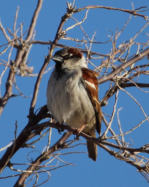
This female house finch was busy gathering materials for a nest at our campground in Hollbrook. Finches have really pretty songs, and they’re enjoyable to listen to in the morning. House finches are an interesting story: they’re native to the American southwest and Mexico, but profiteers captured some finches in the 1940s and attempted to sell them as “Hollywood finches” to bird enthusiasts in New York City. Rather than face prosecution for violating a federal law regarding migratory birds, the people released the finches into the wild and the birds established themselves on the U.S. east coast. In the ensuing years, they’ve moved both east (from the southwest) and west (from the east coast) to be found across nearly the entire country.Here is the mate of the house finch, watching the sunrise the same morning. I’m sure he later helped build the nest, too. The reddish coloration of male house finches changes with the seasons and is dependent on the birds’ diets; as you’ll see, some male house finches are redder than others. For their size, finches have some powerful beaks.This is a very common bird, the house sparrow, but it’s a very pretty one all the same. Mornings are a great time to take photographs of birds because the sun is low in the sky to provide dramatic lighting, and the birds themselves are fairly active.
Grants, New Mexico
The campground at which we stayed in Grants, New Mexico, at the end of March had an adjacent walking trail that wound through a lava field. A relatively recent volcanic eruption, perhaps only 4,000 to 5,000 years ago, produced the black basaltic rock that is everywhere around Grants. The campground’s trail attracted a lot of birds that perched on the trees and shrubs within the lava field, including this female white-crowned sparrow that was singing a pretty song one morning. It was the fifth species of sparrow I’d seen during our stays in New Mexico and Arizona. We really enjoyed this trail, which also provided great views of the surrounding mountains. A national monument, El Malpais (Spanish for “the badlands”) is very near Grants, and we look forward to visiting it in the future.Here’s the other male house finch I alluded to earlier. Dunno what he’s eating to get all of that red coloration, but he’s definitely the reddest finch I’ve ever seen. This was in the campground at Grants; I have a bunch of photos of different birds perched on different types of water valves at campgrounds, for some reason.
Albuquerque, New Mexico
Our next stop on our return north was Albuquerque, which Nancy and I really enjoy visiting. There’s a lot to see and do there, and plenty of great Mexican restaurants and grocery stores to enjoy.
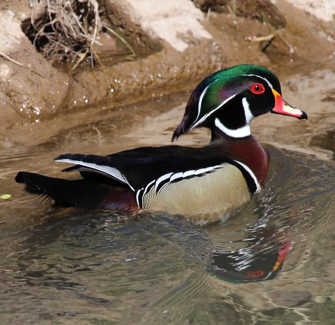
We returned to Albuquerque’s excellent Botanic Garden at the city’s BioPark, which also has a zoo and aquarium situated along the Rio Grande near downtown. In early April the garden had thousands of blooming bulbs, including daffodils, tulips, crocus, and others, as well as a lot of neat birds. This is a male white-crowned sparrow; compare him to the pretty female white-crowned sparrow from the Grants lava field, two photos above. This guy was hunting for bugs on one of the garden’s trails.We watched this mountain bluebird bring a grub to its nest in a tree near the Botanic Garden’s farmstead exhibit. I really like the hue of blue, which contrasts nicely with their rusty chests, on these birds.Gunther and I went for a walk on a trail along the Rio Grande bosque one afternoon and I heard this fellow singing in a cottonwood tree. I couldn’t tell what kind of bird it was at the time because it was so far away, but I got a couple of photos with my telephoto lens. I was a little surprised to see, after looking at it on my laptop, that it’s a spotted towhee. I’d never seen one in a tree before; I’ve only seen them on the ground, scratching through leaves while looking for bugs. (Of course, the next day we went to the city’s Botanic Garden and we saw another spotted towhee there, in a tree.) Spotted towhees are really pretty birds – they’ve got a lot of patterns and colors going on.On that same walk we saw several wood ducks, including this very striking drake, swimming in a canal adjacent to the Rio Grande. I’d never seen wood ducks prior to our first stop in Albuquerque last November. They’re just incredibly beautiful birds (and the hens are quite pretty as well).
Las Vegas, New Mexico
In mid-April we made our way to Las Vegas, which we had also stayed at the previous fall. It was incredibly windy during our stay there in the spring (and the area would be subjected to several wildfires shortly after we left), so we didn’t venture out much. I did take a few photos at the campground, though.
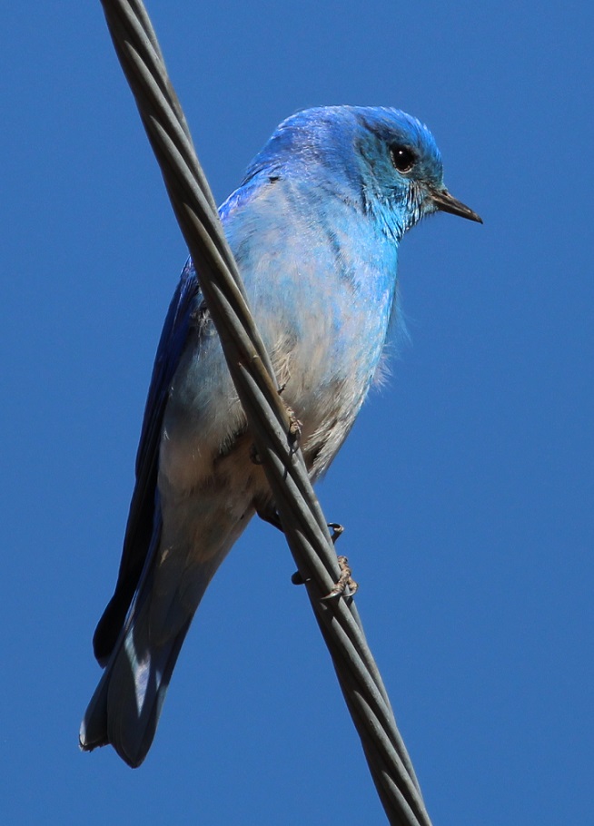
This is a western bluebird, perched on a power line and watching me as I watched it. This is the same species from the cottonwood tree in the Albuquerque Botanic Garden. I’m writing this post while camping in central Arkansas, and I kind of miss those clear blue skies of New Mexico and Arizona. We sure don’t miss the wind, though.Writing about blue skies: this mountain bluebird nearly disappears into them. We’ve seen this species in Colorado several times, including at the cabin near Eleven Mile Reservoir. You can see that the wind was blowing: look at the feathers on his chest.
Lathrop State Park, near Walsenburg, Colorado
We returned to Colorado around the end of April, choosing to camp once again at one of our favorite state parks. Located west of Walsenburg in the southern part of the state, Lathrop State Park has two large lakes, good hiking trails, and incredible views of the Spanish Peaks and Blanca Peak, each of which still had snow. The park attracts an enormous number of permanent and migratory birds each year.
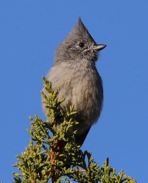
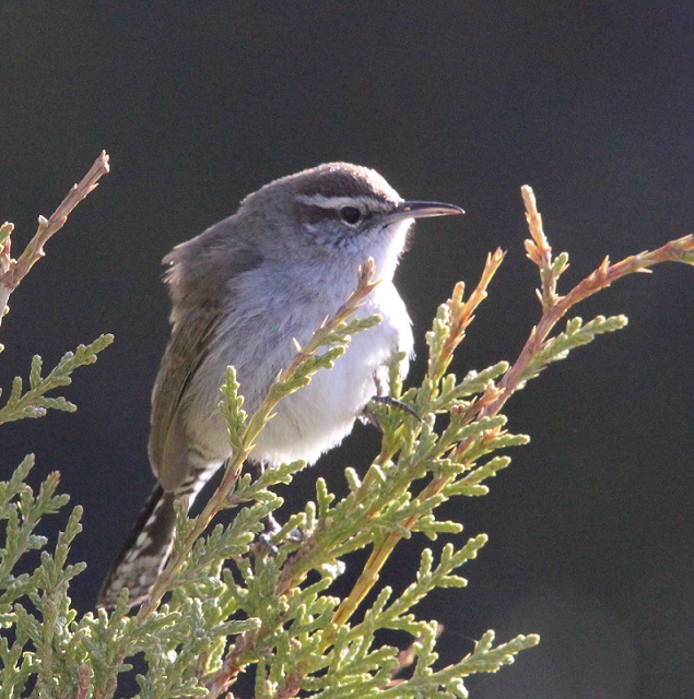
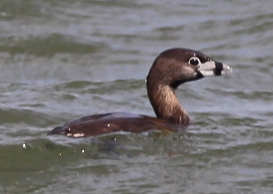
We’d seen a couple of American robins, our first of the spring, at the Albuquerque Botanic Garden, but I couldn’t get any good photos. There were plenty of robins at Lathrop. I’ve learned to recognize their calls, which are really distinctive once you’ve heard them enough.I hiked through the cactus and brush (you’ll notice that most of these songbirds at Lathrop are perched on juniper) north of our campsite one morning and took this photo. I had no idea what kind of bird it was until I looked it up: it’s a tufted titmouse, at the very northern edge of its range in southern Colorado. I’d never heard of them, let alone seen one before. Neat-looking bird, although you don’t see many species, outside of bluebirds and blackbirds, that are all one color.Here’s another new bird to me, from the same morning hike: it’s a Bewick’s wren. I couldn’t get on the other side of it to take advantage of the morning sun, but I kind of like this backlit effect anyway. I’d never seen too many species of wrens before we started full-timing in the Goddard; I’ve since seen several, and they’re very attractive little birds.This is a cropped photo taken with a telephoto lens from a long, long way from this bird, but I’d never seen one before. This is a pied-billed grebe swimming on one of the park’s lakes, and it spent more time submerged than swimming on the surface. I saw eight bird species at Lathrop State Park that I hadn’t yet seen in 2022, and three of them (the last three pictured) were species I’d never seen at all.There were lots and lots of chipping sparrows at Lathrop. I’m not sure if there were more of these or if there were more American robins at the park (and there were a lot of blackbilled magpies, too). Very pretty calls from these little birds.
By the time we left Lathrop State Park on April 24, I’d seen 51 different species of birds in three different states in 2022. It had become obvious that being around water, whether it’s a river or a lake, greatly increases both the chance of seeing birds and the opportunity to see different species of birds. That would become even more clear at the next Colorado state park at which we’d camp.
In the early morning hours of March 9, 1916, a group of Mexican nationals under the direction of General Pancho Villa raided the U.S. Army’s Camp Furlong and the nearby town of Columbus, New Mexico. The town and camp were about three miles north of the Mexican border. Villa’s soldiers, called “Villistas,” were the first foreign forces to attempt a ground attack on the continental United States since the War of 1812.
The reasons for the raid are still under debate more than a century later (and it’s not certain that Villa himself participated directly in the attack), but Mexico was in the midst of a violent and drawn-out revolution at the time and Villa may have been attempting retribution for the United States declaring its support for another political faction within Mexico. Others think that Villa was simply seeking to take the U.S. Army’s supplies and weapons at Camp Furlong to aid in his fight against Mexican rival Venustiano Carranza.
Whatever the motive, the attack resulted in the deaths of 10 American civilians and eight U.S. soldiers, and about 80 Villistas. The town of Columbus was also burned. Within a week, a U.S. Army force commanded by General John J. Pershing entered Mexico to bring Villa and his followers to justice. This “punitive expedition” lasted until February 1917, when the U.S. forces returned north of the border without having captured Villa. However, nearly 200 Villistas and a small number of U.S. Army troops had been killed during the expedition’s battles. The U.S. Army had sent about 5,000 soldiers deep into Mexico in pursuit of Villa, and Camp Furlong was extensively developed to support the expedition. The Mexican general was assassinated, most likely by a Mexican political rival, in 1923.
In the late morning hours of December 26, 2021, Nancy and I arrived at Pancho Villa State Park in Columbus (present day population: around 1,600). The park, 30 miles south of where we were camping in Deming, New Mexico, is on the same ground as Camp Furlong, which had been decommissioned by 1923. The park was established in 1959.
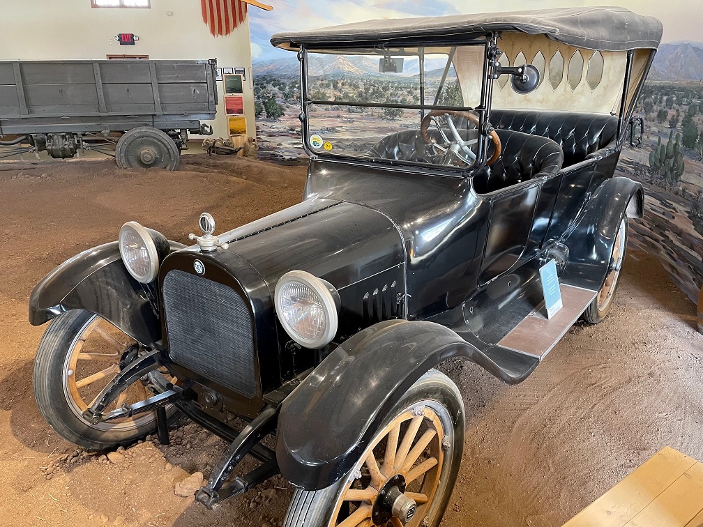
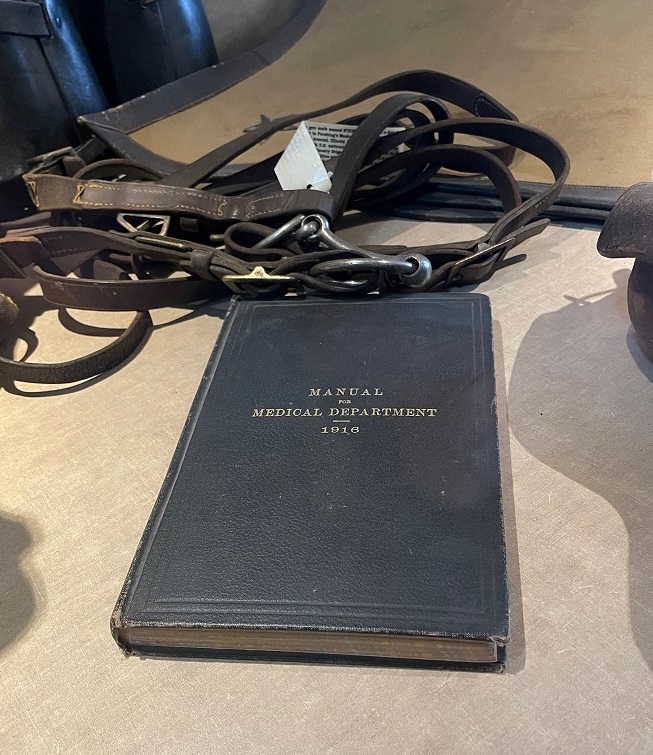
This is the view south from high atop Cootes Hill, a promontory in Columbus from which Villa directed the attack on the town and Camp Furlong. The hill was later became part of Camp Furlong as it expanded to support the pursuit of Villa in Mexico. Columbus is a little more than three miles north of the border, so the mountains in the distance are in Mexico. The campground at Pancho Villa State Park, with 52 campsites built on the former grounds of Camp Furlong, is in the middle foreground.This early U.S. Army armored vehicle is positioned at the entrance to the park’s visitor center. This is an example of the height of military technology at the time of Pershing’s pursuit of Villa in 1916; compare and contrast this vehicle with the M26 tank (named after Pershing) that was in use in World War II less than 30 years later. While the Army’s pursuit of Pancho Villa and his forces didn’t result in Villa’s capture, the effort proved valuable in getting the U.S. Army ready, from troop readiness to vehicle development, for its actions in the European Theatre when the country entered World War I. A replica of a Curtiss JN3 Jenny biplane is suspended above the other exhibits in the state park’s visitor center. Following the raid, Camp Furlong established the first tactical military airfield in the United States, and airplanes like the Jenny provided aerial observation and communication services for the U.S. Army as it chased Villa’s forces in Mexico.Pursuing Villa’s forces across the rough country of northern Mexico necessitated the use of new technology on wheels, including this large truck, in addition to the U.S. Cavalry’s stock of horses and mules. The text above the grille reads “The Four Wheel Drive Auto Co., Clintonville, Wis.”This 1916 Dodge touring car is identical to the model that Pershing used as his mobile field office while in Mexico. Concurrent with the rapid development of mass-produced motor vehicles in the United States, the actions against Villa transitioned the U.S. Cavalry from a horse- and mule-based command to that which relied on motorized vehicles. Pershing would go on to command the American Expeditionary Forces in World War I – for which he’d gained valuable experience in Mexico.The museum at the state park has an extensive collection of military equipment, including weapons, vehicles, uniforms and more, from the pre-World War I era. The slim profile of this 1916 Army medical manual gave me pause. I enjoy putting historical events in chronological context and it’s interesting to think that 50 years prior to the publication of this manual, the U.S. had just emerged from its own Civil War; 50 years later, it would be fighting another war, this one in Vietnam.Some of Camp Furlong’s original infrastructure, such as a raised concrete area in which soldiers changed the oil on newfangled Army trucks, is still to be found in the state park’s campground. Pershing’s expedition to locate Villa was the first time that the U.S. Army used motorized vehicles, including trucks and airplanes, in a campaign; up to that point, it’d been horses and mules (which were also used, of course, in the pursuit of Villa).You’re looking east from the Pancho Villa State Park Campground. On the other side of this campsite’s shaded picnic table and a highway that will take you to Mexico (located three miles south) is the site of the first U.S. military airfield. It was from this location that daring young men took to the skies in their mighty Curtiss Jennies, soaring southward to keep tabs on the Villinistas. El Paso, Texas (and Ciudad Juárez in Mexico) are about 75 miles to the east, as the roadrunner runs.I’ll close with something completely different at Pancho Villa State Park: I was pleasantly surprised to still find blooming wildflowers in late December. This pretty flower is the desert marigold, which is native to the southwestern United States and north-central Mexico; it grows about a foot tall. The state park has an impressive collection of wildflowers and succulents in gardens between the visitor center and the campground.
Some may wonder, and Nancy and I believe rightly so, why there’s a New Mexico state park named after a person who attacked the United States. According to signage at the park, the New Mexico state legislature, in 1959, designated the park in Villa’s name “in recognition of the subsequent long continued friendly relations of the two countries.” Villa had, in turns, been both a friend and foe to the United States, and his story, as well as that of the Mexican Revolution in which he was a major participant, is a complex one. In any case, there’s much to be learned about U.S. history and Mexican history, and the relations between the two countries, at Pancho Villa State Park. Nancy and I had both heard of Pancho Villa prior to our visit to this state park, but our familiarity with him and his exploits ended with just knowing his name. The exhibits at the state park rectified that and encouraged us to learn more about the people involved on both sides of the border, and we enjoyed our visit quite a lot.
One of the few state or national parks where one is encouraged to bring home natural souvenirs, Rockhound State Park is located about 7 miles southeast of Deming, N.M., along the western flank of the Little Florida Mountains. Nancy and I learned, prior to coming to Deming, that Florida in the case of the mountain range is pronounced “flor-EE-duh,” in the Spanish way, much like the Arkansas River is the “ar-CAN-zus” River in Kansas. The Little Florida Mountains are adjacent to the Florida Mountains, separated by a valley. Rockhound a fairly small park, with only about 1.5 miles of hiking trails in the main part of the park. However, it has great views not only of the Floridas but of the open desert to the west, and you can take home up to 15 pounds of rocks! The park has plenty of rocks for the taking, including jasper, rhyolite, and perlite, and geodes – round rocks that have a solid or partially filled (usually with quartz) cavity – can be found as well. The campground in the park has 29 sites.
True to their name, the Little Florida Mountains are a range about three miles long. Rockhound State Park lies between the Little Floridas and the Florida Mountain range, which is about 12 miles long and has mountains ranging from 5,000 to 7,000 feet in elevation. Volcanic activity from millions of years ago is responsible for the appearance of the mountains, as well as the type of rocks at their base.This is a rock that was in the hiking trail; the photo shows an area about a foot wide. I thought it was a very striking rock (some rocks are more striking than others, I’ve found), and it’s held up to thousands and thousands of footsteps. This is jasper, one of the more common minerals in Rockhound State Park. Jasper is from the quartz family and can be red, yellow, brown, pink, white, or all of the above.Rockhound also has a plethora of prickly pear cactus.Rock hound at Rockhound. I told Gunther he’d have better luck at finding the really good rocks if he looked at the ground rather than at the sky, but what do I know?
I believe there’s a state park in Arkansas (pr. ARR-kan-saw) that allows visitors to take home any diamonds they find, but I think Rockhound is the only other park that encourages its visitors to bring away mineral resources. I brought two specimens back to the Goddard.
This is a small sample of perlite,, which is a natural type of glass that is formed by quickly cooling lava that has a lot of silica in it. Perlite is mined in northern New Mexico, and it’s later heated to 1,600 degrees Fahrenheit when it forms small white balls that are used in construction products, filters, and gardening products (gardeners often add perlite to soil to keep it from compacting too much). The ballpoint pen at right is for scale only; it didn’t come out of a volcano.You might think this is petrified wood, and you’d be wrong. This is a mineral called rhyolite, which is found throughout Rockhound State Park (as opposed to petrified wood, in which Rockhound is sorely lacking). The banded contortions show how lava flowed during volcanic eruptions.
We weren’t in the part of the park that featured geodes just laying around, but we saw some really pretty rocks nonetheless and enjoyed a pleasant hike with Gunther. The views, too, were just beautiful, especially looking to the open spaces of the desert to the west. We also brought home two specimens to add to the Goddard’s growing gem and mineral collection, which now numbers two.
We camped at Caballo Lake State Park in mid-November, enjoying a quiet stay in one of the smaller campgrounds at the park. The reservoir is on the Rio Grande River, about 160 miles south of Albuquerque. We were fortunate to be camping next to a very nice retired couple; he worked for the New Mexico Energy, Minerals and Natural Resources Department (EMNRD), which includes the state’s parks, and retired as the superintendent of one of the parks about 15 years ago. They both provided a lot of information about New Mexico state parks in particular and things to do in the state in general.
Caballo is the Spanish word for “horse,” and the Caballo Mountains for which the lake is named are said to resemble the head of a horse. I don’t see it, but they were really, really beautiful anyway, especially at sunset.
A sunset from our campsite at Caballo Lake State Park. This is looking north, not west toward the setting sun; Nancy and I have found that New Mexico’s sunsets often have a 360-degree aspect to them.
The Caballo Mountains are complex because of their geologic history: the oldest granite layers (at the bottom, naturally) date to more than 2 billion years ago during the Proterozoic Eon. That is the time period for which we have the earliest fossil records for life on Earth. The higher sandstone, limestone, and dolomite layers are from the Paleozoic Era, about 500 to 250 million years ago, when this region of New Mexico, and much of the present-day West, was covered by a vast inland tropical sea.
That vast inland tropical sea is long gone now, and the area is now part of North America’s largest desert, the nearly 200,000-square-mile Chihuahan Desert. Nancy took this photo of bunny ears cactus growing near our campsite. While on one of his first walks around the campground, Gunther sniffed a cactus just once, and took great lengths to avoid them thereafter. Some cacti also got barked at.
We took a day trip to Elephant Butte Lake State Park, the largest state park in New Mexico and located about 20 miles north of Caballo Lake, and Truth or Consequences, near Elephant Butte, on Saturday, Nov. 20. One of the buttes around the reservoir is said to look like an elephant; we didn’t see that, either. Elephant Butte Dam was built by the U.S. Bureau of Reclamation and opened in 1916 as the biggest dam of its type in the world. Both Elephant Butte and Caballo reservoirs are now severely depleted of water because of low water in the Rio Grande and its tributaries upstream, but that missing water is especially noticeable at Elephant Butte.
This is the marina at Elephant Butte Lake State Park. The lake is at about 2 percent of capacity, and is really little more than the Rio Grande River. Caballo Lake was at about 6 percent of capacity.Truth or Consequences had a fenced dog park in which we let Gunther run off a little steam. He found a stick. Don’t lose that stick, Gunther – do you think they grow on trees?He had a pretty good time!
There were hundreds if not thousands of sandhill cranes flying over the lake while we were at Caballo, and it was a lot of fun to listen to their calls.
Here’s the Goddard with the sun setting on the Caballo Mountains in the background …… and here’s that sunset. Our stay at Caballo Lake State Park was very relaxing, and I’m glad we stopped there for a few days. The weather was great for the most part, and the skies at night, when clear, provided really nice stargazing.
Nancy and I took a long lunch break to enjoy a hike above the Lathrop State Park campground. The Hogback Trail is a loop providing incredible views of the Spanish Peaks, the Sangre de Cristo mountain range, and the area to the north of the park including Pikes Peak (14,115 feet).
East Spanish Peak (on the left, 12,683 feet) and West Spanish Peak (13,326 feet) are a pair of mountains formed by igneous intrusions (lava flow) that overlook the two lakes of Lathrop State Park. West Spanish Peak is the easternmost mountain in the United States with an elevation greater than 13,000 feet. They were prominent landmarks on the Santa Fe Trail in the early 19th century. The Sangre de Cristo mountain range, topped with an early snowfall, is on the right.The same igneous intrusion process that formed the Spanish Peaks also formed a number of volcanic dikes in the area, including the hogback on which we were hiking.
The famed photographer William Henry Jackson (1843-1942), whose images chronicled the American Civil War as well as the growth of the American West (his famous photograph of Colorado’s Mount of the Holy Cross, along with other images of the areas around present-day Yellowstone and Grand Teton national parks, convinced many people in the east that they needed to travel west), visited the area that is now Lathrop State Park in the 1880s. A short spur hike from the Hogback Trail takes one to the spot where Jackson took the photograph below; I took the one below that one about 120 years later (with the only lens and camera that I had on the hike, so it’s not a great match). Still, a pretty neat experience from a historical perspective.
We’re starting off in Colorado’s first state park, which opened in 1962. The state now has 42 parks across Colorado, and a new one, including the area around Sweetwater Lake in Gypsum, was just announced earlier this month.
Sunset at the entrance to the park. The Sangre de Cristo mountain range is on the western horizon.
Named after Harold Lathrop, the first director of Colorado’s Division of Parks and Outdoor Recreation (now Colorado Parks & Wildlife), the park has two large (for Colorado) lakes that attract a huge variety of migratory birds throughout the year. On a walk around one of the lakes, Ken saw two birds he’d never seen before: a western grebe (which had just happened to catch an early supper) and a juvenile snow goose.
In addition to the grebe and goose, Ken saw American coots, Canada geese, seagulls, American robins, and mallard ducks all enjoying a late afternoon at the lake.
Lathrop State Park is about an hour’s drive east of Great Sand Dunes National Park. On Sunday, Oct. 24, we took Gunther on a visit to the dunes, which are the tallest in North America – some are 750 feet tall.
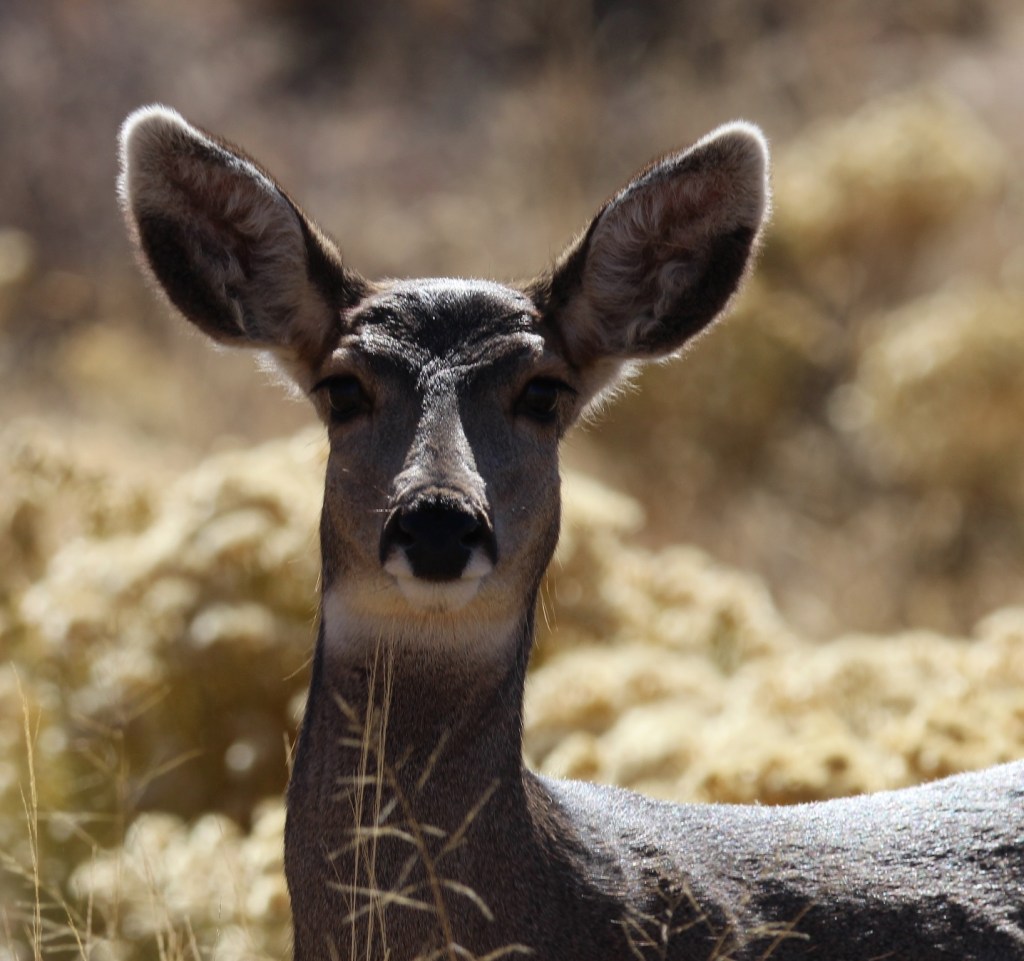
The eastern side of the Great Sand Dunes from the national park’s visitor center, about half a mile away. Mt. Herard (13,345 feet) is in the background. It’s estimated that the dunes contain 1.2 cubic miles of sand (imagine a cube with edges 1.2 miles long and then fill it with sand).We were both surprised at how many visitors the dunes received that day, given the time of year. Many were apparently from other countries, which is fairly common to experience during the off-season. The park attracts about half a million people each year.Gunther had a great time running and jumping around in the sand. We enjoyed ourselves as well, although we neither ran nor jumped.While we enjoyed a picnic lunch in the parking lot of the dunes, a small herd of mule deer paraded by. There were two bucks and probably eight or 10 does like this one.