I’ve been reading “Riders of the Purple Sage,” one of Zane Grey’s early books that helped shape the Western novel formula. Publishing the book in 1918, Grey (1872-1930) was inspired to write a Western story after reading Owen Wister’s “The Virginian” (1902). It would be the most popular of Grey’s 90 books (it’s estimated that he wrote 9 million words in his career). Later prolific western authors like Max Brand and Louis L’Amour were heavily influenced by Grey; L’Amour himself wrote 89 novels and 14 collections of short stories. “Riders of the Purple Sage” has been adapted for film five times: in 1918 and `1925 (both were silent movies), 1931, 1941, and a 1996 TV movie starring Ed Harris and Amy Madigan (who have been married to each other since 1983).
Although I’ve read “The Virginian” and lots of Louis L’Amour’s books, I’ve never read a Zane Grey novel (my only point of reference to Grey was knowing that Colonel Sherman Potter of the 4077th Mobile Army Surgical Hospital was a big fan). I’ve been struck how, in “Riders of the Purple Sage,” Grey deftly describes the canyons, mesas, and flatlands of southern Utah, the setting of the book. The characterization and dialog in the book are definitely of their time, but the story itself is pretty exciting and Grey was quite skilled at painting, in words, how the incredible scenery of the region appears.
Reading “Riders of the Purple Sage” reminded me of when we were in southern Utah and northern Arizona for an extended visit in 2023. We’d planned to stay in Fredonia, Arizona, for four weeks so that we could visit a couple of national parks and monuments in the region. Mechanical issues with The Goddard, our fifth-wheel trailer, extended our stay for an additional week. We were unable to lower the front jacks of our trailer, which meant that it had to stay hitched to the six-wheeled towing unit. A very competent RV technician was able to help us manually lower the jacks and we were able to unhitch our F-350, and he later fixed the jack-lowering issue (turns out a rodent probably chewed through a wire while we were camping at the south rim of the Grand Canyon; lesson learned is to never go to the Grand Canyon again). At any rate, our extended stay while waiting for RV parts was a fortunate one as we were able to visit the north rim of the Grand Canyon, which, due to snow, didn’t open until early June that year.
This post, however, is not about either rim of the Grand Canyon but rather a manmade lake in Utah. Our campground was in Fredonia, Arizona, about four miles south of the Arizona/Utah border. We spent quite a bit of time in Kanab, Utah (itself about four miles north of the border), partly because we found a reservoir near Kanab that offered great hiking and birding opportunities. We visited the lake three times in late May and early June, and this post has pictures from all of those excursions. We saw lots of different species of birds, and we were fortunate to have timed our visit for some pretty impressive displays of blossoming plants.
The average depth of Jackson Flat Reservoir is only 28 feet. It’s primarily a holding reservoir for irrigation water, but the lake receives plenty of non-motorized boating, hiking, swimming, fishing, and stargazing enthusiasts. The sage in this photo isn’t purple like in the Zane Grey book, but maybe it’s due to the time of day that I took the picture.
Jackson Flat Reservoir, located between Kanab and the state line, had been in its planning stages for nearly two decades when construction began in 2010. The reservoir meets local agricultural irrigation needs, and is also a wonderful boating, swimming, and hiking destination for Kanab residents. Built to a capacity of 4,228 acre-feet, the reservoir attracts a large number of waterfowl and other birds to southeast Utah.
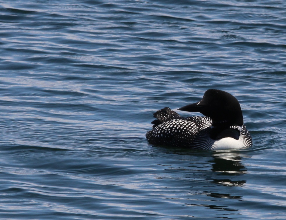
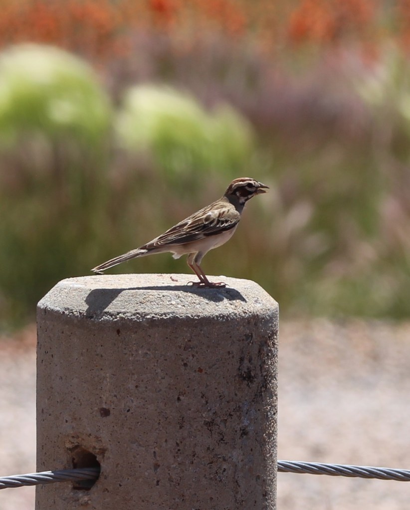
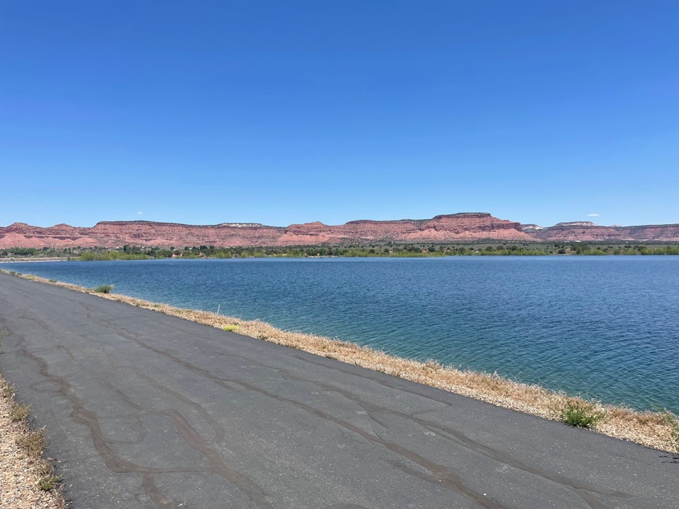
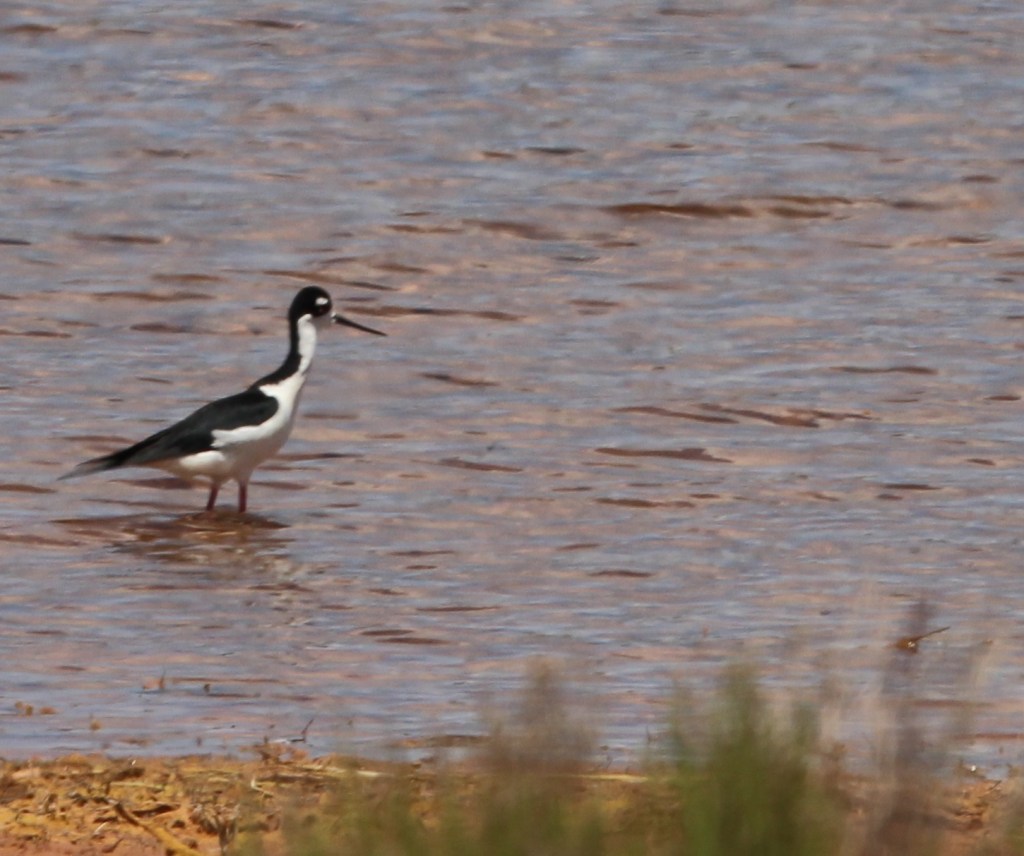
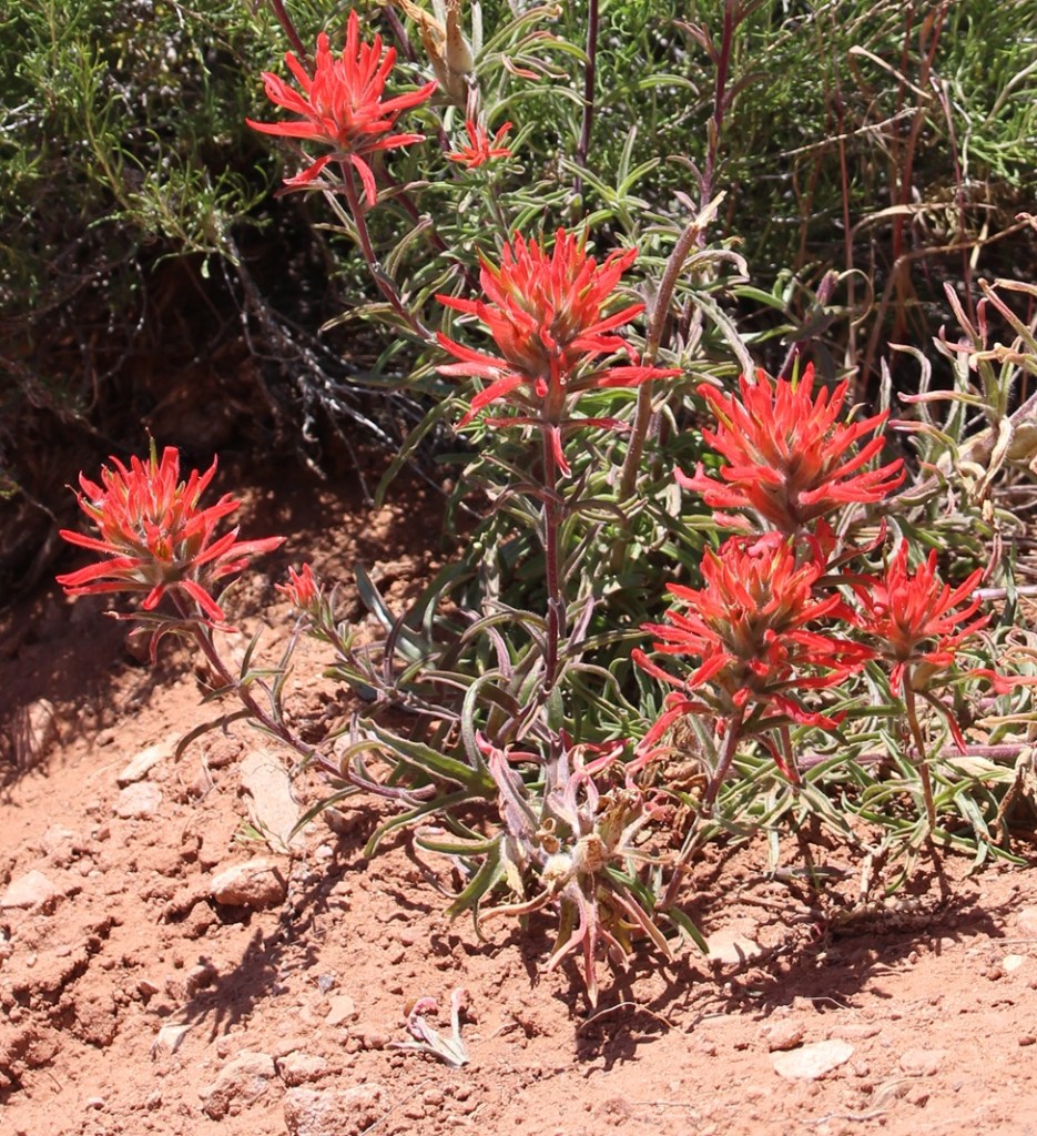
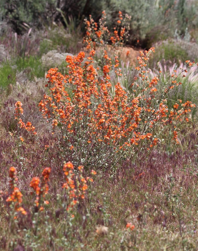
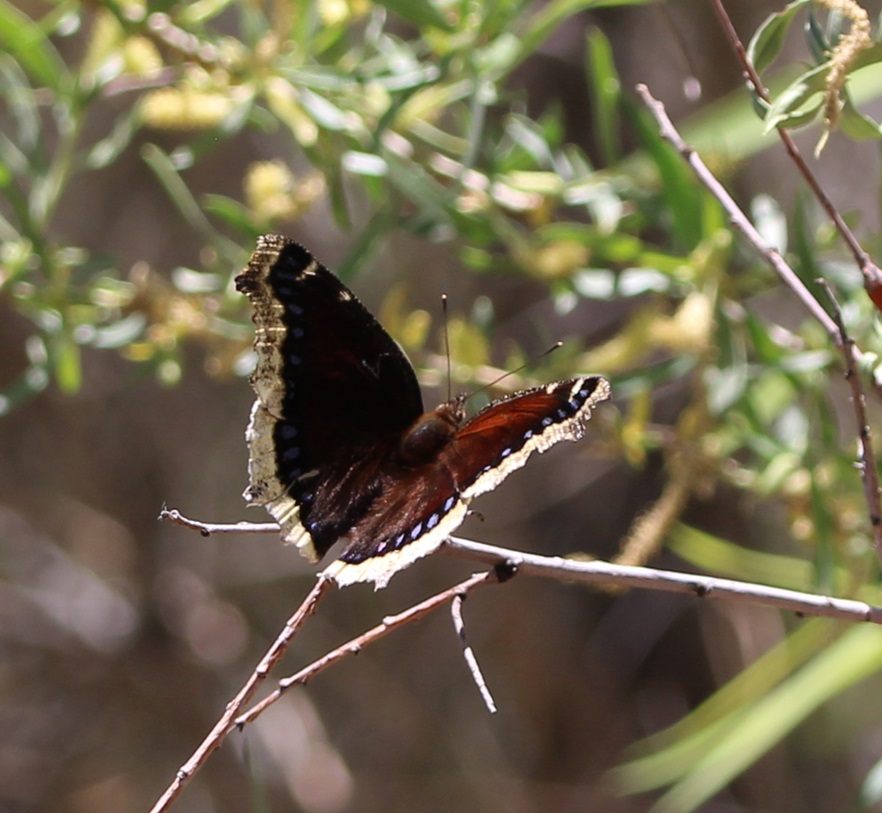
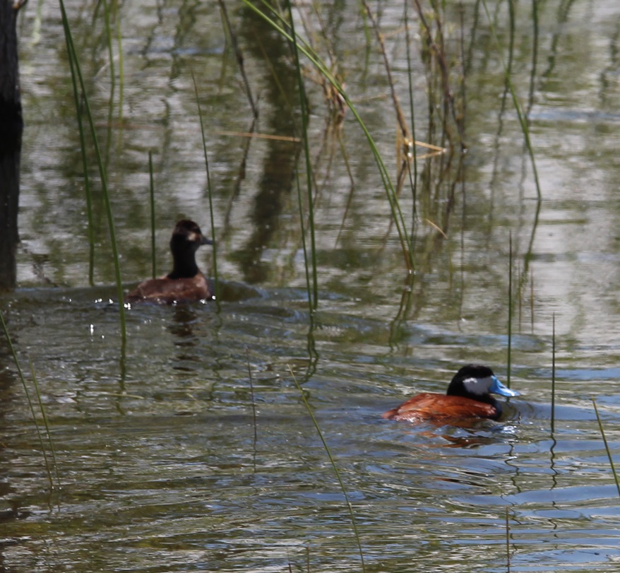
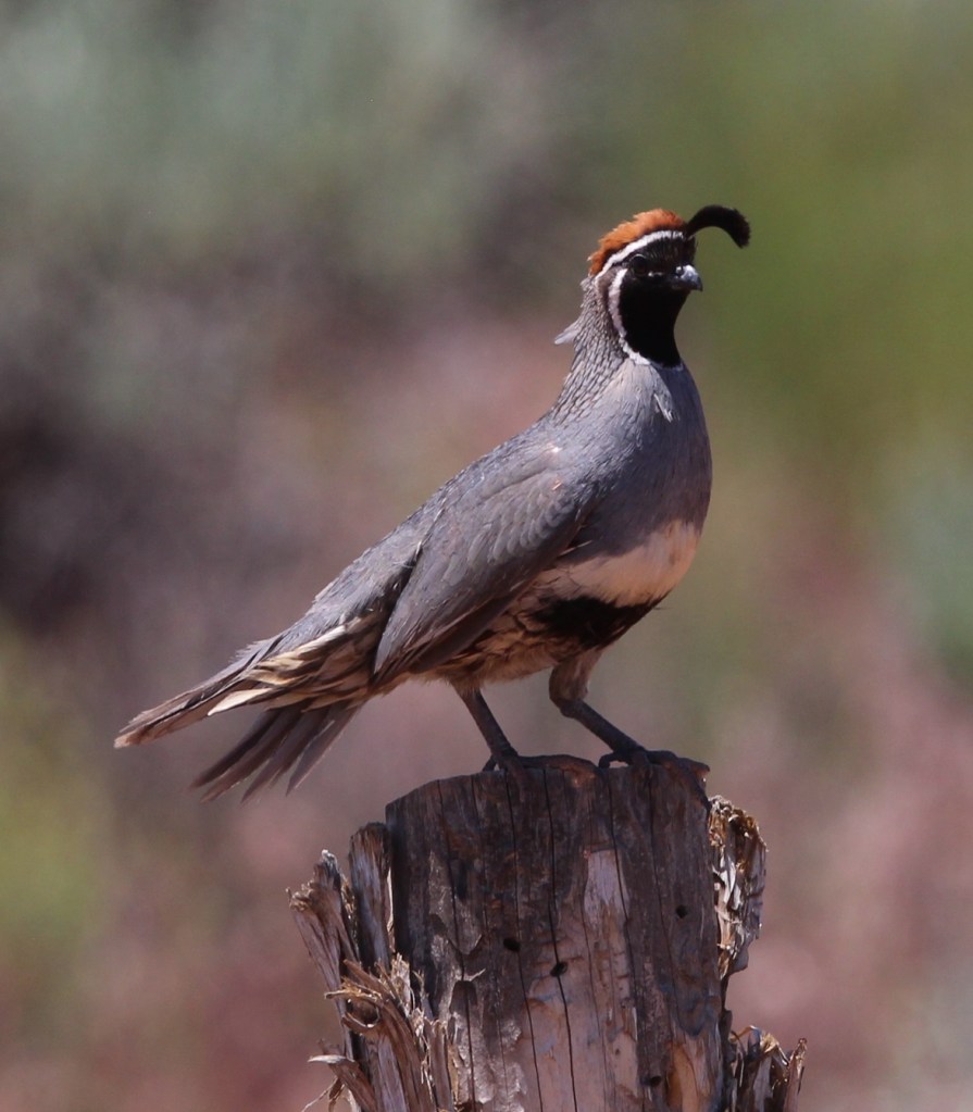
Birds with predominantly black coloration are frustratingly difficult to photograph unless the lighting is just right; I really like the pattern on this common loon (Chondestes grammacus) so I decided to include the picture in this posting. Nancy and I watched this bird for quite some time; it would disappear under the water for up to a minute at a time, and it was kind of fun to guess where he’d pop back up. Their diet consists mostly of crustaceans and small fish. Common loons are found all over the United States – it’s likely how they got their name.Writing of “common,” here’s a common raven (Corvus corax) behind a juniper bush, looking much like a Muppet. True to their name, these birds are the most common of corvids (a family of birds that also includes crows, magpies, and jays), and, weighing in at 3.2 pounds at maturity, they are the largest of the passerine order (basically birds that perch, about half of the species on the planet). On our walks around the lake, we saw several ravens being chased in the air by red-winged blackbirds that were presumably defending their nests.Writing of which, here’s a red-winged blackbird (Agelaius phoeniceus) patrolling water’s edge. “But Ken,” you might think to yourself, “this bird is neither red-winged nor black.” I would agree with you, and likely add that it looks like one of the 70 million species of brown-colored sparrows. This is, however, a female red-winged blackbird, which do not have the black color and red wing markings of the males of the species. You can differentiate a female red-winged blackbird from a sparrow by looking at the beak: it’s much more pointed and angular than say, …… the beak of this brown-colored sparrow. This is a lark sparrow (Chondestes grammacus), a species we seemingly see sparingly, but is actually fairly common and distributed throughout most of the United States and Mexico. To remind us that we were in an arid desert environment, there were several varieties of cactus growing around the reservoir. This is tulip prickly pear (Opuntia phaeacantha) featuring riotously vibrant colors on its blossoms. Whenever I see bright colors like this on flowers, or a bird, or a tropical fish, I think, “There’s a color not found in nature.” But they are literally found in nature. This is the road over the dam of Jackson Flat Reservoir, with the cliffs of southern Utah in the distance. The Grand Staircase-Escalante National Monument’s western border is just to the right edge of this photograph. The reservoir’s dam contains 800,000 yards of dirt and rocks. One thing I like to do when seeing a reservoir’s dam is to cry out “Dam!” I wonder if Nancy ever gets tired of me doing that. I should probably ask her sometime. We see a lot of dams.Some of the waterfowl we saw were far away from the trail that goes around the reservoir. This was a new species to us, so I decided to include it even though it’s a terrible photo. This is a black-necked stilt (Chondestes grammacus). It’s found in the western United States and down into Mexico, and in quite a bit of South America as well. They are about 15 inches tall, with long pink legs and a wingspan of close to 30 inches. Like other shorebirds, black-necked stilts use their long bills and beaks to feed on freshwater shrimp, as well as crayfish and small fish. Species like these have no business being in the arid desert of southern Utah, except for the existence of Jackson Flat Reservoir – it’s a great benefit to area residents to be able to see birds like this.Indian paintbrush has long been one of my favorite wildflowers. There are more than 200 species of this plant; I’m pretty sure this is Wyoming Indian paintbrush (Castilleja linariifolia), which is the state flower of … Wyoming.THIS IS A TALES OF THE GODDARD LIZARD ALERT. Movement at the side of the trail around the reservoir attracted our attention to this western fence lizard, a very common reptile in the western United States. Note the blue patch on his throat; that blue shading also extends to his stomach (I’m guessing; I didn’t pick this rascal up to check) and leads to another name for the lizard: the bluebelly. There are five subspecies of western fence lizards; they have a SVL (snout-vent length) of 2.25 to 3.5 inches.As I wrote earlier, we happened to time our visits to Jackson Flat Reservoir when many flowering plants were blossoming. The flowering of this plant, desert globemallow (Sphaeralcea ambigua), lasted throughout our entire stay in the region: it was everywhere. It generally grows to a height of three feet, and is host to the caterpillar stage of a number of butterfly and moth species.Writing of which, here’s a butterfly species called the mourning cloak (Nymphalis antiopa). This butterfly is found in both North America and Europe. Because it feeds on sap from trees and shrubs, it’s not a significant pollinator.Back to birds: here is a couple of double-crested cormorants (Nannopterum auritum), contemplating a cooling dip in the waters of Jackson Flat Reservoir. Although they are definitely water birds, their feathers are not waterproof and they are often seen standing on the shore with their wings spread out in order to dry off. Their diet is exclusively fish-based.One of the facets of birding that I really like is the opportunity to see pairs of a particular species. The males and females of many species are often seen close together, and you get the opportunity to see how the two genders differ in appearance. This is a pair of ruddy ducks (Oxyura jamaicensis), easily identified by the male’s bright blue bill which only appears that way during the summer months (it’s gray the rest of the year).There are a number of really distinctive-looking birds of which I’d only seen pictures or video footage of, but never in real life until Nancy and I started full-time RVing. I’ll never forget seeing a wood duck in real life for the first time (at a state park in Albuquerque, New Mexico), or a scarlet tanager (at a campground in Tucson, Arizona), a common loon (on a lake in western Michigan), a northern cardinal (at a campground in Oklahoma) or a greater roadrunner (at a campground in Albuquerque). I’ve now seen all of those species several times in the last three years, but it’s always a thrill to see them again. The Gambel’s quail (Callipepla gambelii) is another of those birds: I first saw them at a regional park outside of Phoenix, Arizona, and I’ve seen them many times since then, but it’s still really fun to encounter them because of their distinctive appearance. This species is native to the American Southwest, and is also found in parts of Colorado and Texas.Gunther found this lovely stand of desert mallow on a walk near our campground in Fredonia. During our stay in northern Arizona, we saw about 50 kajillion of these flowers; at times, the landscape looked like a sea of pink-orange coral. But “Riders of the Pink-Orange Desert Mallow” doesn’t really have the right zing, and Zane Grey was probably right to title his novel the way he did.
We were fortunate to be near south-central Utah’s Bryce Canyon National Park on June 8, 2023 – the date happened to be the one hundredth anniversary of the park’s founding as a national monument. We had to leave Gunther at home (no dogs are allowed on the park’s trails, which is perfectly understandable) so we weren’t able to stick around for centennial celebratory cake at the park’s visitor center; however, if the cake was half as good as the park’s views, it was some mighty fine cake.
Because of its remote location, Bryce Canyon National Park receives significantly fewer annual visitors than nearby Zion National Park or Grand Canyon National Park. Kanab, Utah (pop. 4,800 and a stone’s throw from the Utah/Arizona border) is the closest town of any size, and it’s an hour-and-a-half drive away.
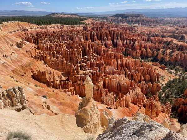
Ummm … yeah. The world is full of natural wonders, and the United States is home to quite a few of those places, and the Rocky Mountain West boasts its fair share of incredible views, but Utah is just stacked with scenic sites – it includes five national parks within its borders. The uncountable vertical rock formations in the foreground, boasting hues of red, yellow, and white, are called hoodoos. They’re formed, as are most really cool rock formations, by erosional processes. Bryce Canyon National Park contains the world’s greatest concentration of hoodoos.
Bryce Canyon National Park is the easternmost and highest “step” in the Grand Staircase, an immense geologic structure stretching across 100 miles of southern Utah and Arizona. The Grand Staircase includes two dozen distinct layers of rocks representing 525 million years of sedimentation from ancient inland seas, lakes, swamps, and forests. Arizona’s Grand Canyon contains the oldest rock layers and forms the western and lowest edge of the Grand Staircase.
Bryce Canyon National Park: By The Numbers
Date established as a national park
February 5, 1928 (declared a national monument on June 8, 1923)
Total area
35,835 acres (56 square miles, about one-seventh the size of Rocky Mountain National Park in Colorado)
Yearly visitors
2.4 million (RMNP receives 4.3 million)
Highest point
Rainbow Point, at 9,105 feet
Lowest point
Yellow Creek, at 6,620 feet
Despite its name, there aren’t any significant geologic canyons in the national park – the erosion of the limestone cliffs into the hoodoos and other formations we see today is mostly the work of frozen water rather than a flowing river. Between 55 and 35 million years ago, what is now Utah was a basin filled with mountains. Rivers in those mountains deposited tremendous amounts of dissolved limestone into huge lakes. About 20 million years ago, the Colorado Plateau was uplifted and the lakes were drained to expose the limestone layers that form the beautiful rock formations of Bryce Canyon. Erosional forces, including freezing and thawing water as well as rain and snow, over the ensuing years carved cliffs out of the limestone, which were eventually further sculpted into narrow walls called fins and then eventually rows of the rounded columnar formations called hoodoos; if you look at pictures of hoodoos and imagine the spaces filled with rock, that’s what the fins used to look like.
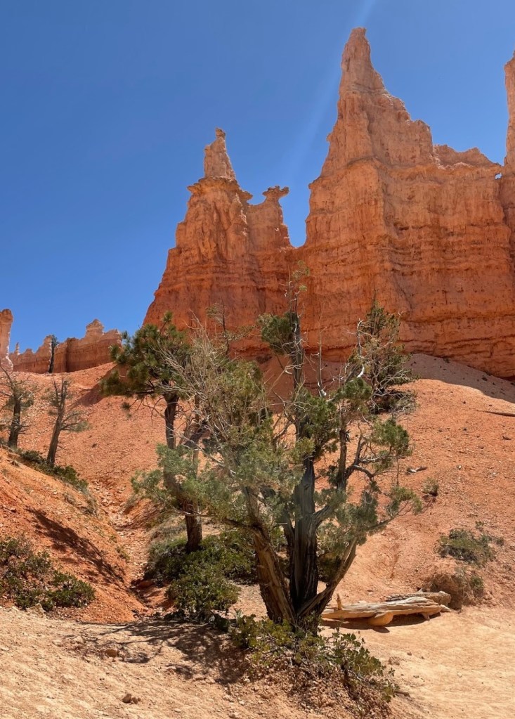
Although the skies weren’t crystal-clear the day we visited the national park, we still had some incredible views from the overlooks. This image was taken looking east. In addition to the marvelous rock walls and hoodoos in the foreground, formations 20 miles away and even further could be easily seen. Canaan Peak has an elevation of 9,293 feet. A winding hiking trail can be seen in the mid-foreground on the right side of this image.The national park’s namesake, Ebenezer Bryce, was born in Scotland in 1830. He was a ship’s carpenter and, after converting to the Church of Jesus Christ of Latter-day Saints, emigrated to the United States in 1848. He married Mary Park in Salt Lake City in 1854, and the family (which then included five children; he and Mary would have a total of 12) moved to southern Utah’s Pine Valley in 1862. Shortly thereafter, he moved to a homestead in the nearby Paria Valley which is south of the present-day national park. He built a road for timber access that ended in a natural bowl-shaped area, or amphitheater; that area became known as “Bryce’s Canyon.” In 1880, he and his family moved to Arizona, near Pima, where he passed away in 1913. [Photo courtesy Washington County (Utah) Historical Society.]The name of this pretty flower, the sego lily (Calochortus nuttallii), derives from a word (“sikoo”) in the language of the Shoshone, who taught early (and hungry) Mormons that nearly all of the plant, including the bulb, is edible. The plant’s value as an important pioneer foodstuff later led to the adoption of the sego lily as Utah’s state flower in 1911. The large-grained grass at left is Indian ricegrass (Eriocoma hymenoides), also an important part of native Americans’ diets. It is the state grass of both Utah and Nevada.The second column from left shows a “window,” in which the erosional power of frozen water, in the form of snow, frost, and ice, wedges small crevices into larger openings. It’s very likely that frost and rain will erode away the rock forming the top of the window, resulting in the columnar shapes called hoodoos. Because of its elevation, Bryce Canyon National Park experiences freezing temperatures half of the nights of the year.After enjoying the views from several overlooks while on a scenic drive around the park, we embarked on a fairly challenging hike in the early afternoon that combined the Navajo Loop with the Queen’s Garden Loop. It gave us the opportunity to walk on wooded footpaths, see plenty of wildflowers and birds, and marvel up-close at the rock formations. These hikers are walking past some hoodoos that have several windows.Here’s a view of the Queen’s Garden Loop namesake: if you squint at the top of the hoodoo just left of center, you can kind of maybe sort of make out something that resembles Victoria, Queen of the United Kingdom of Great Britain and Ireland (1819-1901). Did You Know/Care: there are almost 160 statues of Queen Victoria around the world. Also, I think it’s fun to imagine Queen Victoria saying the word “hoodoo.”THIS IS A TALES OF THE GODDARD LIZARD ALERT. Western fence lizards (Sceloporus occidentalis) have a wide distribution throughout the American West, and can live at elevations ranging from sea level all the way up to almost 11,000 feet. You can just begin to make out the most distinguishing characteristic of this species, its bright blue belly (look behind the right front leg).Nancy and I are both very experienced hikers and both of us recognize the need for switchbacks, or gradual increases in elevation by constructing a trail across the slope of an incline. These switchbacks at the end of the hike that day were the most in a relatively short distance that we’ve ever seen. It seemed like we walked 30 miles just to gain 300 feet of altitude. Still, it was an intensely rewarding hike and it was a great end to a great day at Bryce Canyon National Park.Looking northeast, this overlook at the end of the Queen’s Garden Loop awaits after that significant set of serious switchbacks. I mean, I’m writing this post one year after our visit to the park and I’m still just shaking my head at the views we experienced.THIS IS A BONUS TALES OF THE GODDARD LIZARD ALERT. This horned lizard was not at Bryce Canyon National Park, but in our campsite near Hatch, Utah, where we stayed for the week during our visit to the park. Horned lizards (I believe this is a greater short-horned lizard) are extremely well-camouflaged little creatures. Our campground was only 32 miles from Bryce Canyon National Park, but the winding drive took 45 minutes. We may have missed out on centennial-celebrating cake so we could make sure Gunther got outside for his afternoon walk, but, between the overlooks and hike we enjoyed, it was well worth it. Because of its remote location, Bryce Canyon is definitely a park that you have to want to get to, and that’s okay by us (but you should totally want to get to it).
Grand Staircase-Escalante National Monument is big – really big. In fact, although it’s the seventh-largest U.S. national monument by size, it’s the biggest in the country that’s not either entirely in or adjacent to an ocean. At 1.87 million acres (just over 2,900 square miles), the national monument is nearly twice as big as the entire state of Rhode Island, and just a tad bigger than the state of Delaware.
This area in southern Utah is vast, and it is remote: it was the last part of the contiguous United States to be mapped by the federal government. Grand Staircase-Escalante National Monument was authorized by President Bill Clinton in 1996. This is also one of the more contentious federal properties; President Donald Trump effectively halved its acreage in 2017, and then President Joe Biden restored it to its current size in 2021. It is the first national monument to be administered solely by the Bureau of Land Management (BLM).
(A brief sidenote: the U.S. government’s holding of lands, especially at the levels of national monuments and especially those in the western United States, is criticized by some groups and lauded by others. Much of these lands frankly isn’t good for anything except looking beautiful and supporting native plants and animals – which, in the eyes of some, is more than enough reason to provide federal protection. Other groups are interested not so much in the lands themselves, but what’s under the lands’ surfaces: minerals, petroleum, and other extractive materials. Everyone from kayakers to native Americans to miners to anglers to ranchers to tourists wanting a scenic drive has an opinion on what should and shouldn’t happen on these lands. U.S. presidents are able to establish and change landholdings under national monument status as they see fit; acts of Congress are needed to establish or change national parks. I’m someone who enjoys nature quite a lot, but I also realize that I use minerals and petroleum extracted from the earth nearly every minute of every day – in the laptop I’m typing on, in the fifth-wheel trailer in which we live, and in the iPhone and digital camera with which the following photos were taken. You most likely are equally dependent on those extractive resources. As with most issues in life, it takes a balance. Grand Staircase-Escalante National Monument is especially contentious because county and state governments also want to maintain at least some control over what can and can’t happen within its borders.)
(That sidenote was less brief than I’d expected.)
Anywho, Grand Staircase-Escalante National Monument takes up a sizable chunk of southeastern Utah. It protects three major areas: the Grand Staircase, the Kaiparowits Plateau, and the Canyons of the Escalante. The Grand Staircase is so named because of its stepped appearance if viewed from the side: from west to east, the landscape drops in elevation in enormous eroded and even layers. The steps drop, west to east, in cliffs measured in hundreds of feet. The area represents 400 million years of geologic development.
The views at Grand Staircase-Escalante National Monument are simply spectacular. The monument is bordered by Bryce Canyon National Park on its western edge and by Glen Canyon National Recreation Atea on its eastern side.
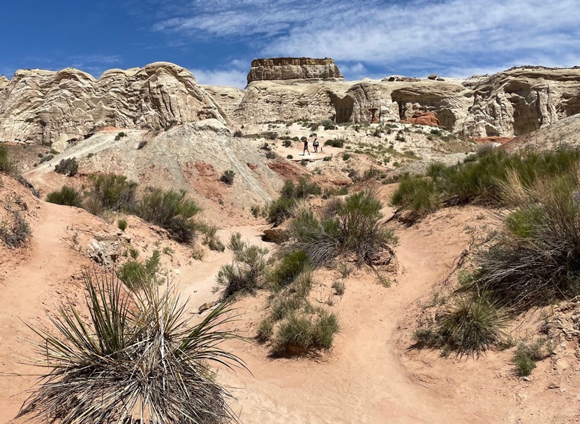
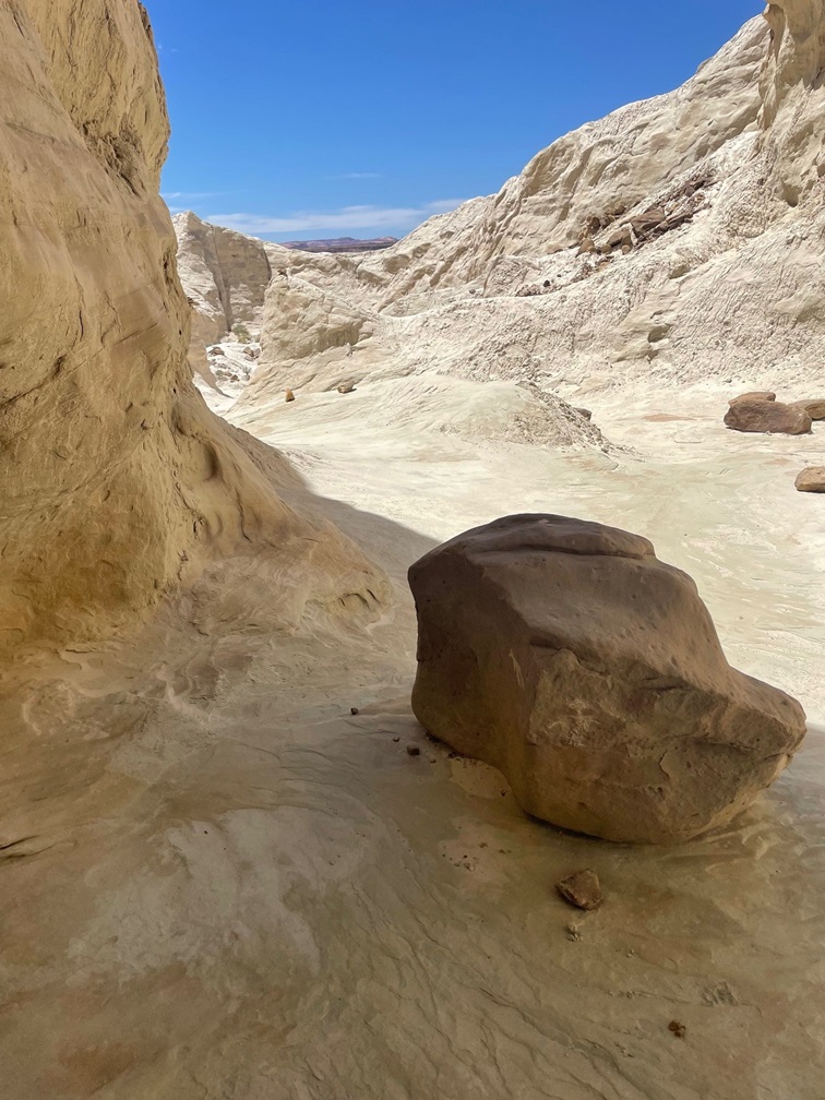
One fun thing to do in these federally protected lands is to go on a hike, and that’s what Nancy and I did in late May of 2023. The Toadstool Trail leads to some wonderful rock formations and other features of this otherworldly environment. In its easy out-and-back 1.5 miles, one can see rocks eroded from water, rain, and other elements to create some pretty stunning scenery. We happened to visit the area when a number of flowering desert plants were in bloom, which was great to see.
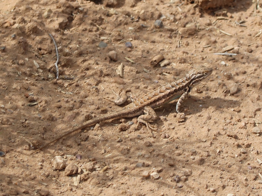
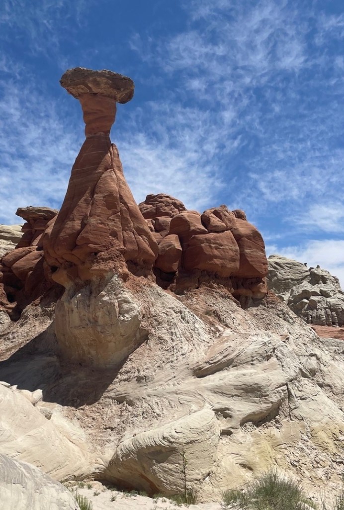
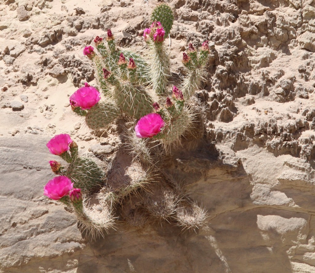
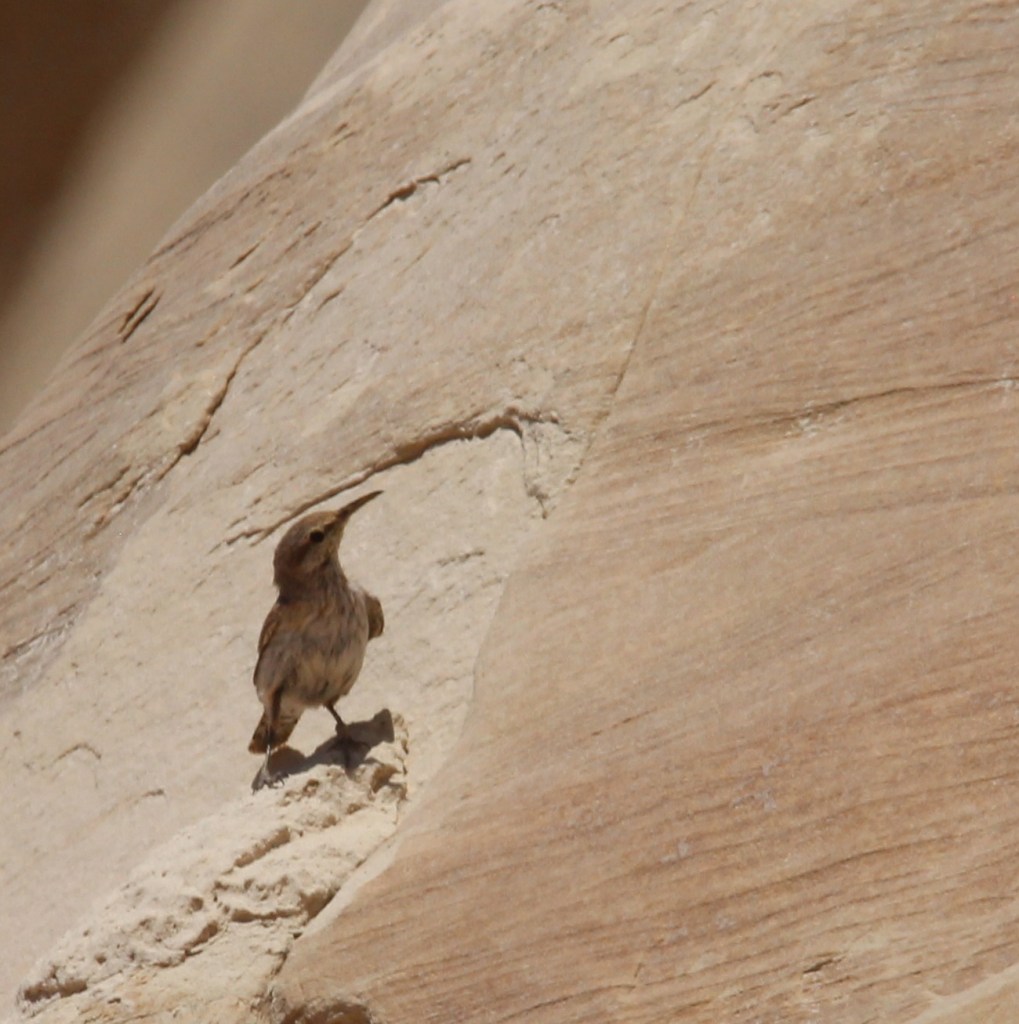
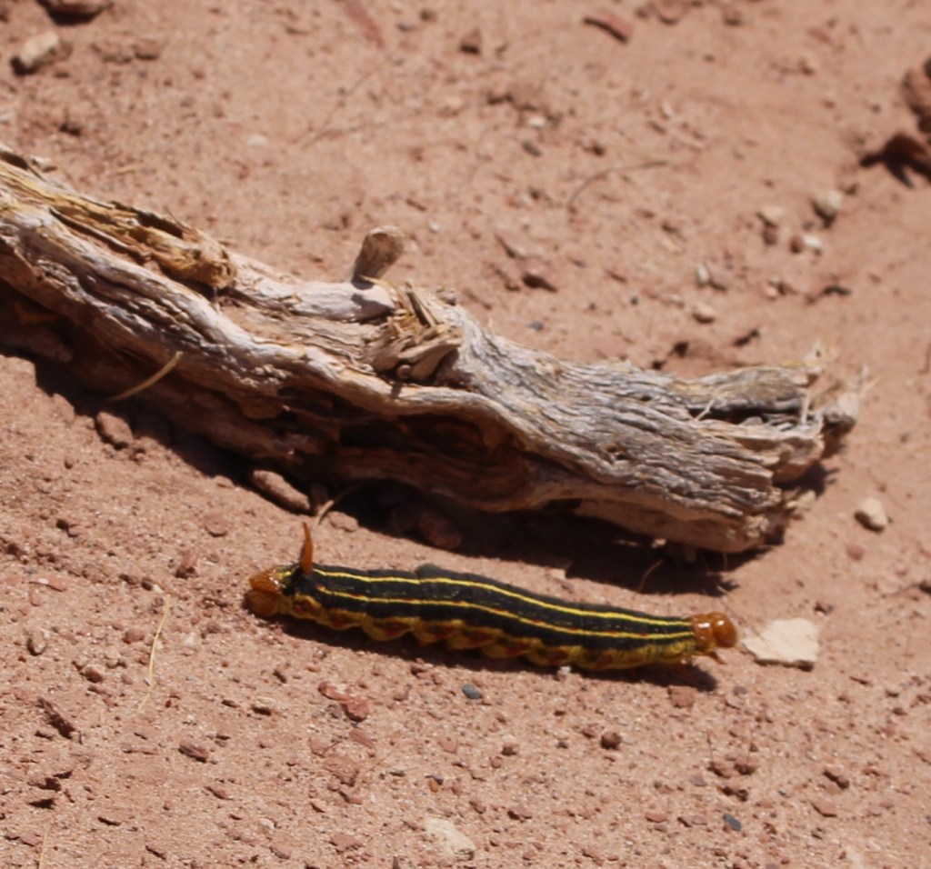
We visited the national monument on a beautiful day in late spring, when there was little chance of rain, but there was plenty of evidence that the area receives considerable amounts of moisture at times. This ravine was cut by a seasonal watercourse; the hiking trail is at the far right of the photo. Note the coloration of the different layers of rocks in the cliffside.This pretty flower is a sego lily (Calochortus nuttallii), which happens to be the state flower of Utah. We saw quite a few of these blossoms, which can measure up to three inches across, on the hike. “Sego” is believed to derive from the Shoshone name of the plant.There’s a lot going on in that cliff, not the least of which is the wavy nature of the rock layers on the left. I took this photo from a U-bend in the trail (it continues on the left and right of the photo) and you can see some hikers near the center of the photo.This is a TALES OF THE GODDARD LIZARD ALERT. I’m not an expert on reptile identification (I’m not really an expert on anything, come to think of it), but I believe this to be a common side-blotched lizard (Uta stansburiana). They grow to a length of about 2.5 inches not including the tail, which is often longer than the body. Judging from the Wikipedia page on these little rascals, a lot of the scientists have spent a lot of time observing this species. This is a lizard that can safely lose its tail to escape a predator, but that comes at a terrible cost: loss of social status within a group of other common side-blotched lizards. We saw several of these lizards and all still had their tails, so we were among the elite. This isn’t the first lizard species to live in the area; researchers have found fossils of several different dinosaurs within the borders of the monument.This is the largest rock formation from which the Toadstools Trail gets its name, and it’s plenty spectacular. If I had to guess, I’d say the column is about 25 feet tall. Formations like this occur when softer rock under harder, denser rock is eroded away. These are basically small buttes, with more material underneath the surface caprock taken away by water, wind, and other erosional forces, to form a toadstool formation.I thought this rock wall was interesting because it shows not just the colors of the different rock layers, but the different density of the layers as well: note the edge-on layers of rocks upon which less-dense layers, which are disintegrating faster, were deposited over millions of years.The bright blossoms of this plains pricklypear (Opuntia polyacantha) were hard to miss in an otherwise tan-colored environment. The flowers of this species of cactus can be yellow, red, or magenta, as on this specimen. These plants provide a source of food for quite a few animals, like prairie dogs and pronghorns, and many people enjoy eating the fruit (if animals haven’t gotten to them first) once the blossoms are spent.Although the larger toadstools are very impressive, the rock formation – a column supporting a wider, flat cap of harder stone – is fairly common in the area. They make for some interesting viewing opportunities.This is Coulter’s lupine (Lupinus sparsiflorus), also known as Mohave lupine or desert lupine. The plants grow to a maximum height of about 16 inches. We’ve seen this pretty flower elsewhere in the deserts of the western United States; it, along with the other plants that happen to be flowering at the time, provides a nice pop of color.This blurry photo is unfortunately the best of three I took before this rock wren (Salpinctes obsoletus) took off to raise havoc somewhere else. This species, fairly common in the western part of the country, is adapted to cling to rock faces while hunting for insects and spiders.Shortly after we’d started this hike, another hiker suggested that we continue walking past the main toadstool formations for some really nice views, more toadstools, and balanced rocks. We took his advice, and we’re glad we did. I’m going to guess that it’s six or eight miles to the horizon. Here we see a lone hiker (it’s Nancy) looking west; Kanab, Utah, is about 40 miles thataway.In this very arid environment, anything that moves and (especially) is not some shade of brown quickly catches your eye. This caterpillar is the larval stage of a really nifty moth called the white-lined sphinx, or hummingbird moth (Hyles lineata). The adult version of this species can be easily mistaken for a hummingbird as it hovers over blossoming flowers. The species is very common from central America up into Canada, including most of the United States. The spike at the back end of the caterpillar isn’t a stinger but it does give this larval form another name: hornworm. They aren’t harmful to humans but given a big enough population, these voracious eaters can destroy cultivated crops and flowers. Conversely, the adult moth form is beneficial for plants because of its ability to pollinate while feeding.That hiker who suggested that we continue our walk past the main formations was absolutely right, and we were able to see some really pretty toadstools and long vistasThe yellow blossom on the left is red dome blanketflower (Gaillardia pinnatifida), while the white blossom belongs to a flowering plant called birdcage evening primrose (Oenothera deltoides). Because they don’t require a lot of care, blanketflower species are very popular in home flower gardens – I planted some of them in our xeriscaped lawn in Denver.The cliffs, toadstools, balanced rocks, and other rock formations in the national monument were created by erosion and plenty of time. I’m including this photo to show how even tiny trickles of water coming down a rock face can create really interesting designs.Native American cultures arrived in what is now the national monument around 1,500 years ago. There are hundreds of petroglyphs that document those peoples’ existence in the area, and the rock in the foreground looks to have two of them. This was at the mouth of a very short canyon eroded into a cliff wall.Here’s a closeup of one of the petroglyphs on the rock pictured above. I have no reason to think it’s not genuine, but I sure can’t think of any horned quadrupeds that also have long tails. Maybe it’s a depiction of something else entirely.On the way back to the trailbead, another hiker with a digital camera and long lens was as excited as me to see this bird about 50 yards away from us. We couldn’t identify the species at that distance, so I was certainly looking forward to getting back to the Goddard and looking at the picture on a larger screen. “What kind of exotic birds could possibly live in this remarkable desert environment?” thought I, taking picture after picture of a bird I couldn’t make out through the camera lens. Turns out, it’s a house finch (Haemorhous mexicanus) which is common all over the country so it’s not nearly as exciting as I first thought. However, I’ve gone some days without seeing any birds at all and those days aren’t any fun so I’ve learned to appreciate all the birds I see, no matter how common they are.This photo was not taken on the Toadstools Trail, but I wanted to include it in this posting about Grand Staircase-Escalante National Monument. It shows a spectacular bluff above a former townsite called Paria, which was a Mormon settlement from 1870 to 1929. The town was abandoned because it kept getting inundated by floodwaters. It must have been a tremendously hard way of life, separated from other communities by dozens of miles, but at least the view was pretty good.