When I was a boy, growing up in the town of Flagler (population: around 600 in the 1980s) in eastern Colorado, there wasn’t much to do in one’s free time but I never got bored.
Flagler was very fortunate to have a movie theater that presented movies on weekend nights, except on those weekend nights when the Flagler Panthers hosted high school football, basketball, and volleyball games since everyone went to those instead of “the Show,” as we called it. That theater, still in operation and sporting a new digital projector and new seating, was where I first saw movies like “Raiders of the Lost Ark” (1981) and “E.T. the Extraterrestrial” (1982), instilling in me a deep and lifelong appreciation of the movies.
For more entertainment, there was a reservoir a few miles east of town that was so full when we first moved to Flagler in 1979 that the lake was overflowing its impoundment dam. It was a favorite destination for eastern Colorado anglers and waterskiers – unthinkable now because, due to agricultural demands for water downstream, the reservoir has been no more than a muddy drainage of the Republican River for many, many years.
I remember my high school chums and I, perhaps after the Show, cruising the six blocks of Flagler’s Main Street in our vehicles on weekend nights by putting the transmission in “D” and taking our foot off the brake. It provided some good times, at three miles an hour.
Much of the lack of boredom of my childhood is due to the many other pastimes available in eastern Colorado: museums, other movie theaters, and attractions like the World’s Wonder View Tower.
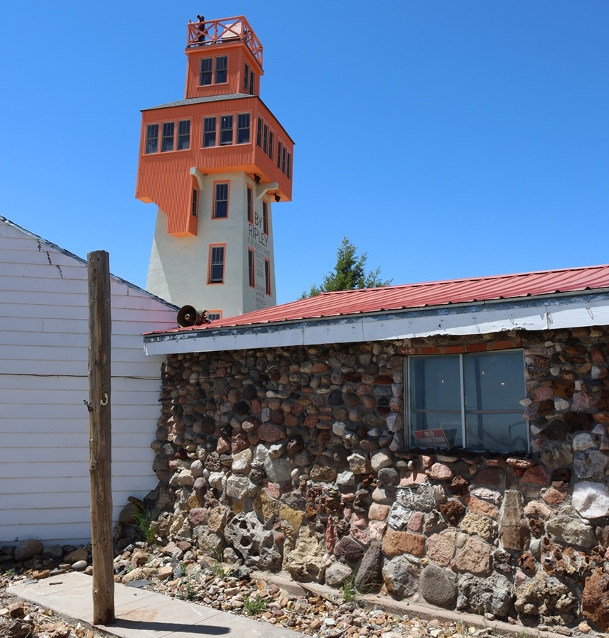
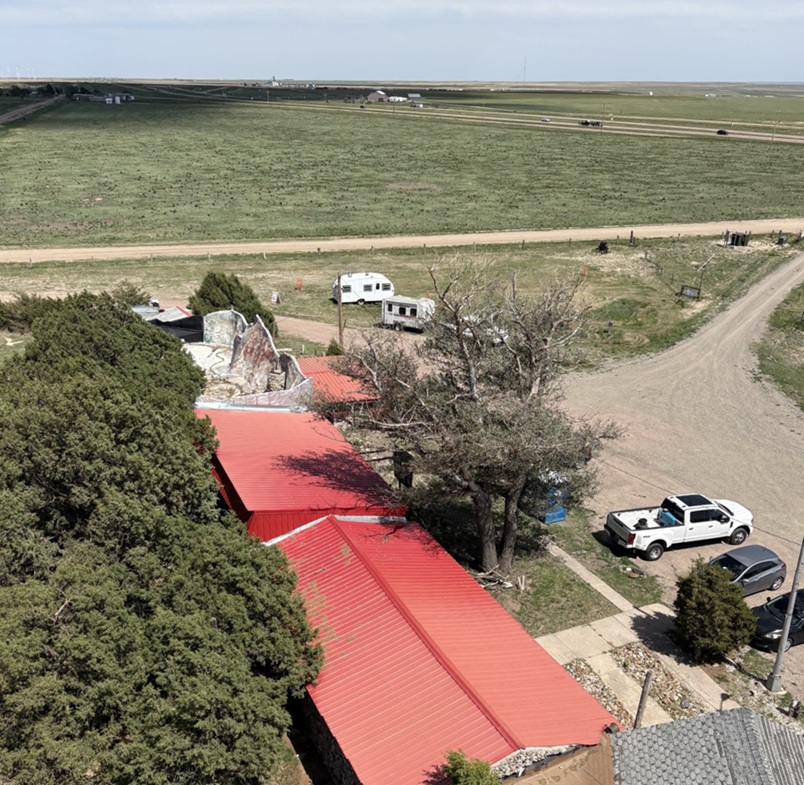
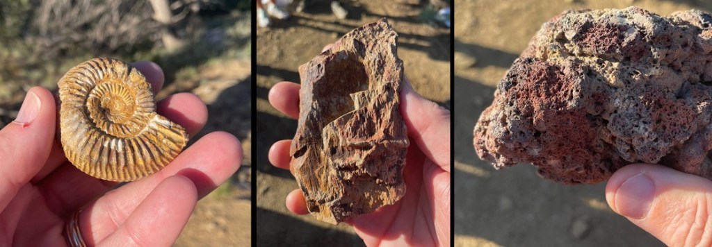
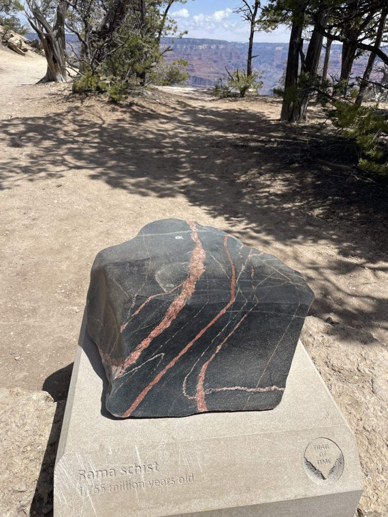
The rock building in the foreground is the museum part of the World’s Wonder View Tower, with the namesake attraction just behind on the left. When I was a boy, the entrance to the museum and the tower was a door just to the right of the window in front. Note the wide variety of rocks used in the building’s construction. Note also a person at the top of the tower; I was to later discover that was either my old Flagler high school chum Gary Beedy, or Gary’s brother, Steve. The Beedy brothers, fourth-generation Genoa-area farmers, are strong supporters of the World’s Wonder View Tower’s restoration and happened to be at the tower the same day we were, and we were pleasantly surprised to see them in the tower’s entrance a few minutes after I took this photo. Eastern Colorado comprises about 40,000 square miles (making it about the size of the entire state of Kentucky), but it can sometimes be a mighty small place.
Located 25 miles west of Flagler in Genoa, Colorado (population in the 2020 U.S. Census: 153), the complex that includes the World’s Wonder View Tower was built in 1926 by Charles Gregory and his partner, Myrtle LeBow. Genoa itself was named after the sixth-largest city in Italy and was located near a natural spring that had attracted wildlife, Native Americans, and Anglo-American explorers to this high spot on the arid plains. Gregory had camped in the area in his younger days, and returned to Genoa to build a top-flight tourist attraction that happened to be right next to a new United States highway.
The decade of the 1920s saw huge growth in the popularity of seeing the United States by automobile, which was further aided by the development of the U.S. Numbered Highway System in 1926. Gregory and LeBow originally built a roadside stop at this location that included a gas station, café, and stage for entertainment. The couple later expanded the amenities to include guest rooms and the 65-foot-tall tower structure.
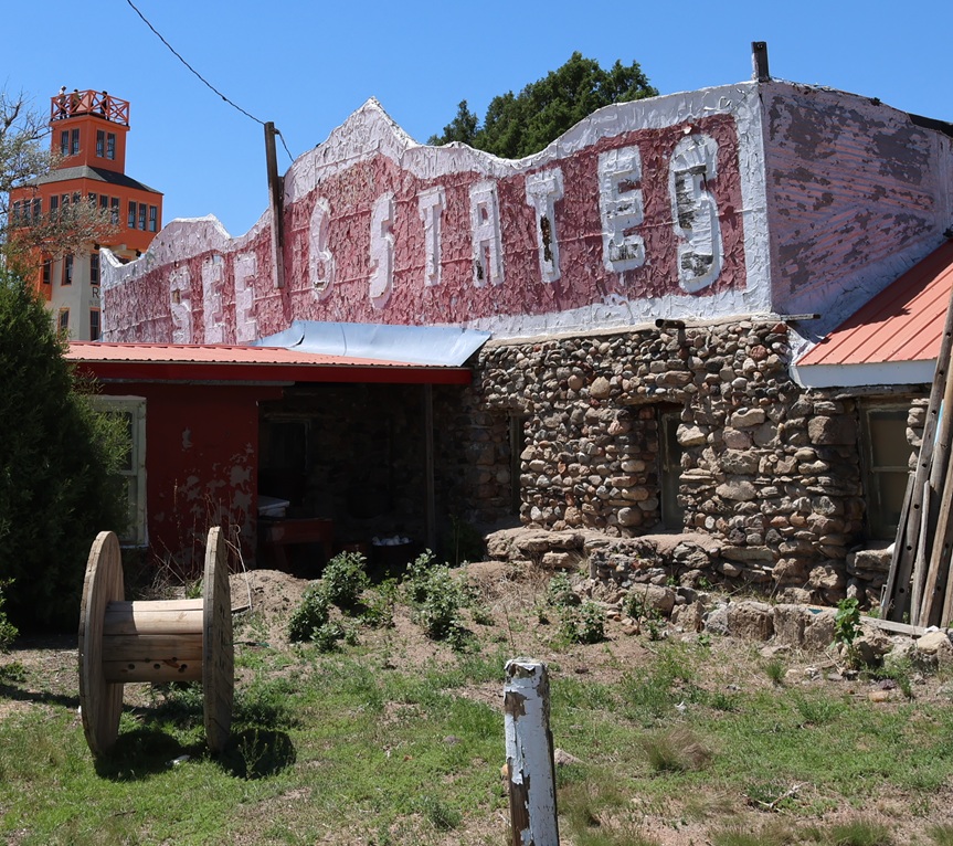
This faded façade is one of my lasting memories of visiting the World’s Wonder View Tower (we just called it “the Genoa Tower,” and no one seemed confused about what we were discussing). The current stewarding organization of the tower complex has focused its efforts on restoring the World’s Wonder View Tower itself, and rightly so.
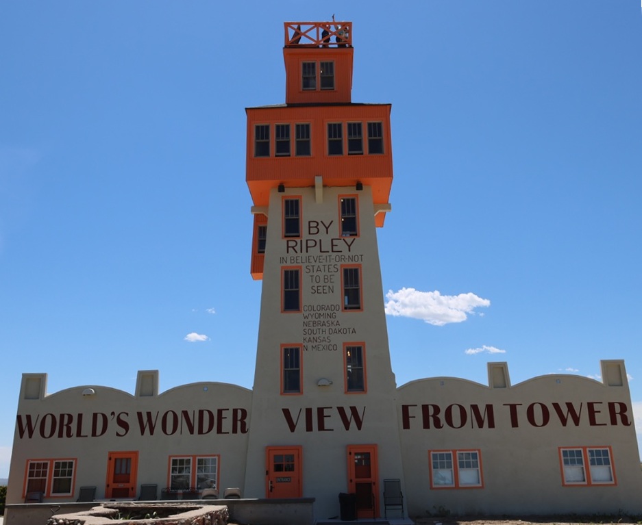
When completed, the World’s Wonder View Tower, which begins at Genoa’s elevation of 5,604 feet (1,708 m) was the highest point between the Palmer Divide of the Rocky Mountains to the west and the mountains of the eastern United States. The tremendous height of the tower affords simply spectacular views in all directions of the compass.
In 1933, no less an authority than Ripley’s Believe It Or Not confirmed that six states – Kansas, Wyoming, South Dakota, Nebraska, New Mexico, and, of course, Colorado – could be seen from the top of the 65 tower. Our tour guide on our June 2026 visit, who accompanied our group to the top, used the word “technically” fairly often when she spoke about the opportunity to see a half-dozen states, such as “Technically, you can see South Dakota.” I finally said “You’re throwing the word ‘technically’ around quite a lot …” and she responded with the expected (and I’m paraphrasing), “We just don’t want to wind up in litigation.” Completely fair, I think.
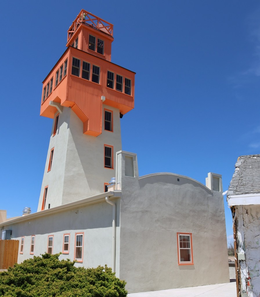
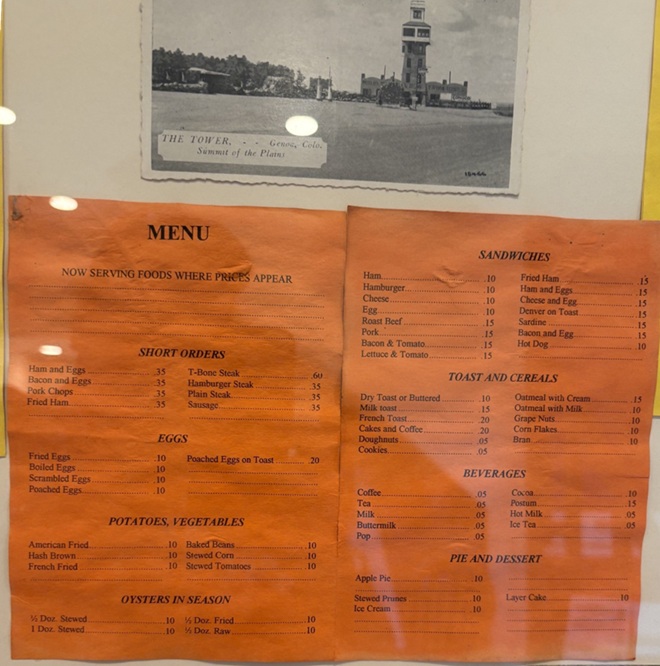
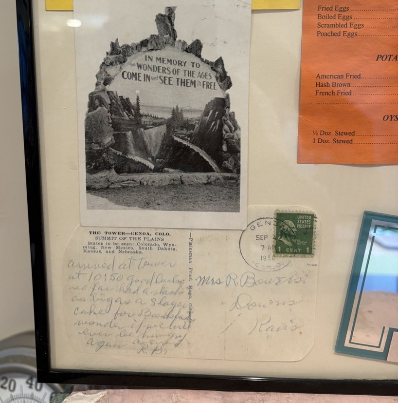
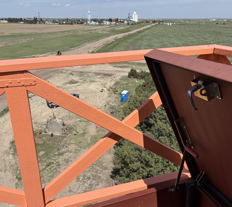
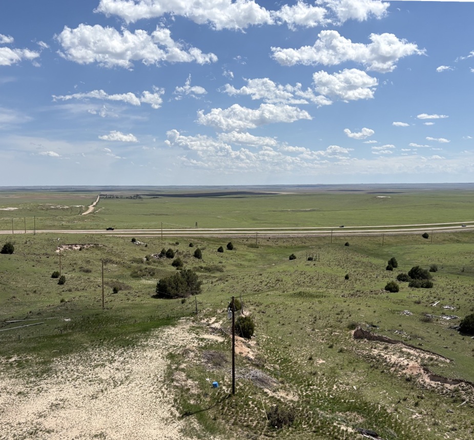
This picture was taken from the east side of the World’s Wonder View Tower. The tower’s original entrance was here on the east side because U.S. Highway 40N (which would be redesignated U.S. Highway 24 in 1936) passed by the tower a few yards to the north. In the 1970s, with the development of Interstate 70 south of the tower, the attraction’s entrance was moved to the south side for easier accessibility. When restoring the tower, the entrance was re-located back to this side of the building. I believe that’s Gary and Steve Beedy still at the top of the tower; I don’t know if they could see the six states of Colorado, Wyoming, Nebraska, South Dakota, Kansas, and New Mexico, but they could almost certainly see their farm located a few miles north of Genoa. Gary and Steve’s great-grandparents first homesteaded the farm in 1893, 33 years before Gregory and LeBow began building this attraction.Here’s a look at the 65-foot-tall World’s Wonder View Tower from its southwest corner. Jerry Chubbuck built an apartment for his family that connected the building on the left with the one on the right; See Six States LLC restored the two buildings to their original and individual states. The new paint job, based on historic photos of the buildings, looks fantastic.In a frame and behind glass inside the tower’s entrance, here are a postcard (“THE TOWER – – Genoa, Colo. Summit of the Plains”) and a menu from when the tower had a café. Nancy and I both wondered about the provenance of OYSTERS IN SEASON. I wouldn’t pass up a piece of apple pie, though, especially at 10 cents.To the lower left of the menu, here are a couple more historic postcards. The bottom one, which has a Genoa (Colorado, not the capital of Liguria in Italy) postmark of April 7, 1950, is addressed to Mrs. R. Bowers of Downs, Kansas (located in the north-central part of the Sunflower State), and reads: “Arrived at tower at 10:50. Good luck so far. Had a stack” (presumably of pancakes, although they’re not on the menu pictured above) “as big as a 5-layer cake for breakfast, wonder if we could ever be hungry again.”This is a picture of a picture at the tower’s entrance of Jerry Chubbuck (October 22, 1930 – August 4, 2013), who owned the World’s Wonder View Tower from 1967 until he passed away. Jerry, who was born in Arriba, Colorado, about 13 miles east of Genoa, was a fascinating person with wide-ranging interests in archeology, geology, paleontology, Native American cultures, and more. He converted the tower’s overnight guest rooms, café, and other rooms into a winding museum that was sort of overwhelming in its scope. It contained exhibits of thousands of arrowheads, dozens of telegraph and telephone line insulators, mammoth fossils (that he discovered), a taxidermied two-headed calf, World War I and World War II-era military memorabilia, petrified wood samples and other rock collections that went on forever, old and obscure farm and ranch tools and machinery, and much more. Jerry had stories about nearly everything under the museum’s roof, and I have fond memories of Jerry greeting visitors at the front door, collecting one dollar in admission, and then offering to refund their dollar if they could guess what historic artifact (usually some sort of old and obscure farm tool or implement) he happened to be holding in his hand. I’m here to tell you: there were some weird and specialized things manufactured in the old days, and I never, despite Jerry’s patience and hints, got my dollar back from any of my visits. Under Jerry’s stewardship of the Genoa Tower, it became a pretty famous landmark along Interstate 70. My other lasting memory of Jerry, who obviously loved sharing his knowledge with others: after telling you what some artifact was and how to use it, he’d end his sentences with, “Yep. Uh-huh. R-i-i-i-ght.” I think the world needs more people like Jerry Chubbuck.
Jerry passed away in 2013, and the site fell into disuse for several years until some Colorado history aficionados, determined to save the property from fading from the map, formed a limited liability corporation (enigmatically called “See Six States LLC”) to acquire the tower and surrounding buildings and land. See Six States LLC put the property in the hands of a nonprofit group called Friends of the Genoa Tower, the board members of which include Patricia Calhoun, who co-founded the Denver alternative weekly newspaper Westword in 1977 and was, until her pending retirement in the summer of 2026, the newspaper’s editor-in-chief. Troy McCue, another high-school chum of mine, is also a member of the Friends of the Genoa Tower board; he’s now the executive director of Lincoln County Economic Development, which promotes and maintains job creation and business growth in this eastern Colorado county in which Genoa is located.
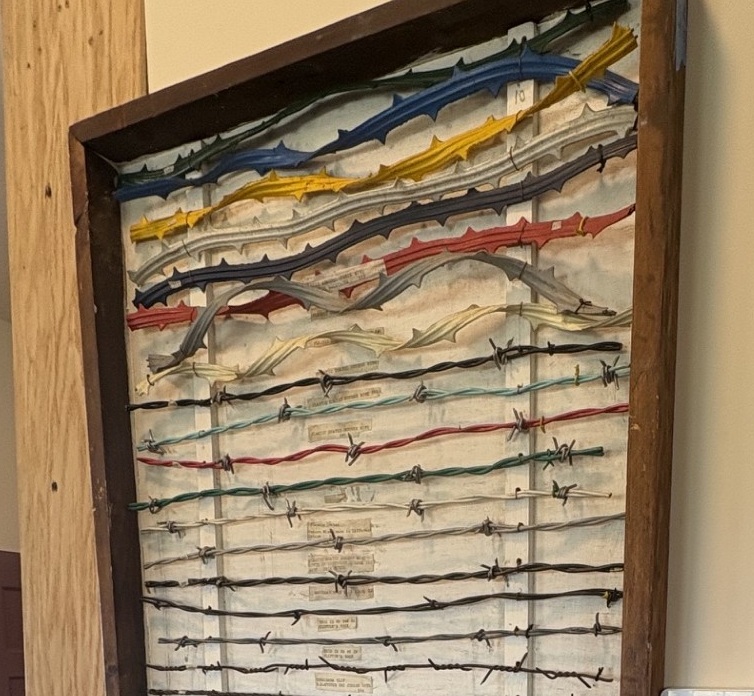
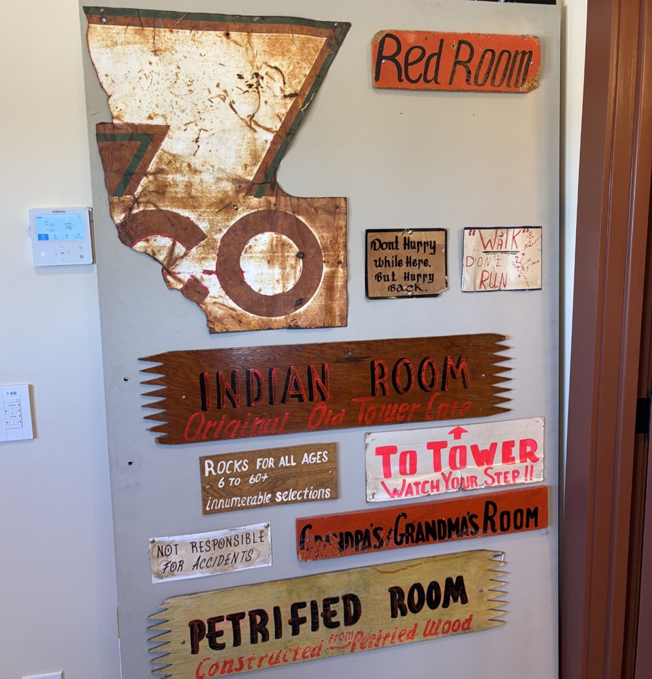
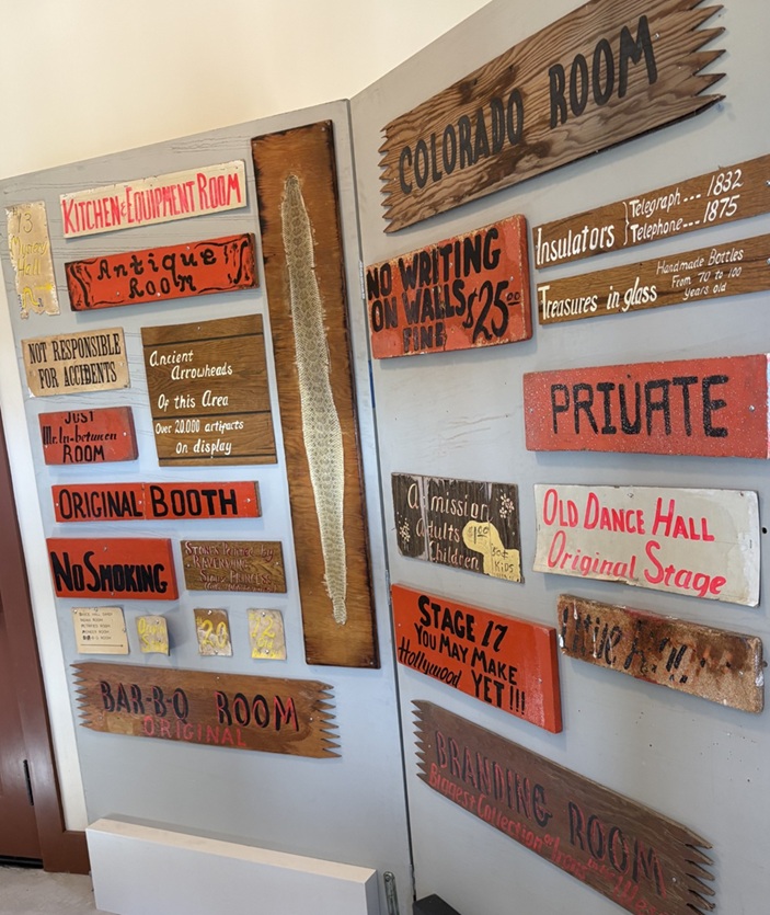
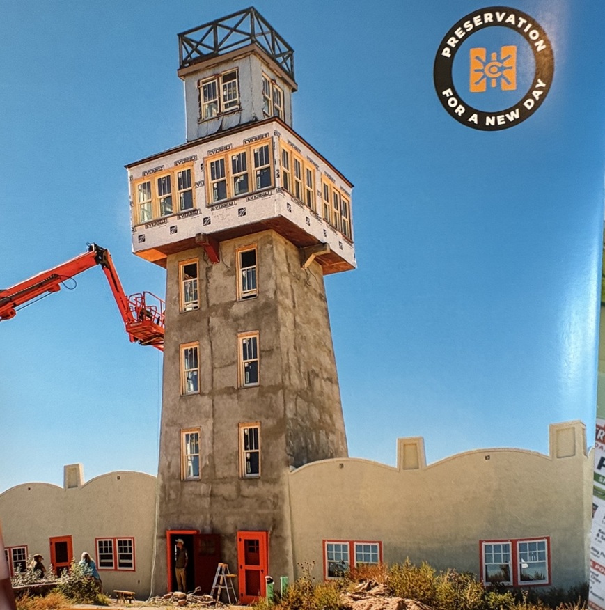
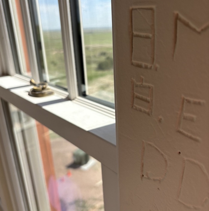
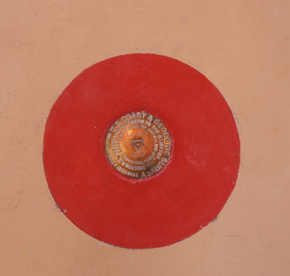
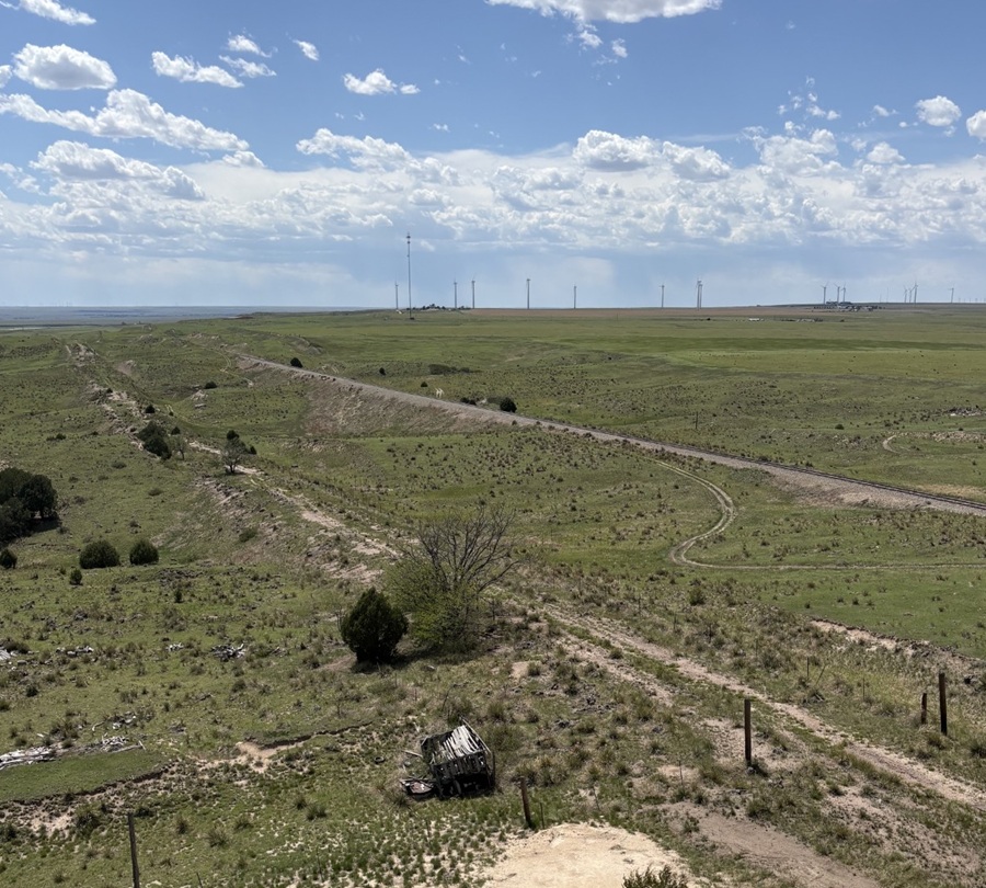
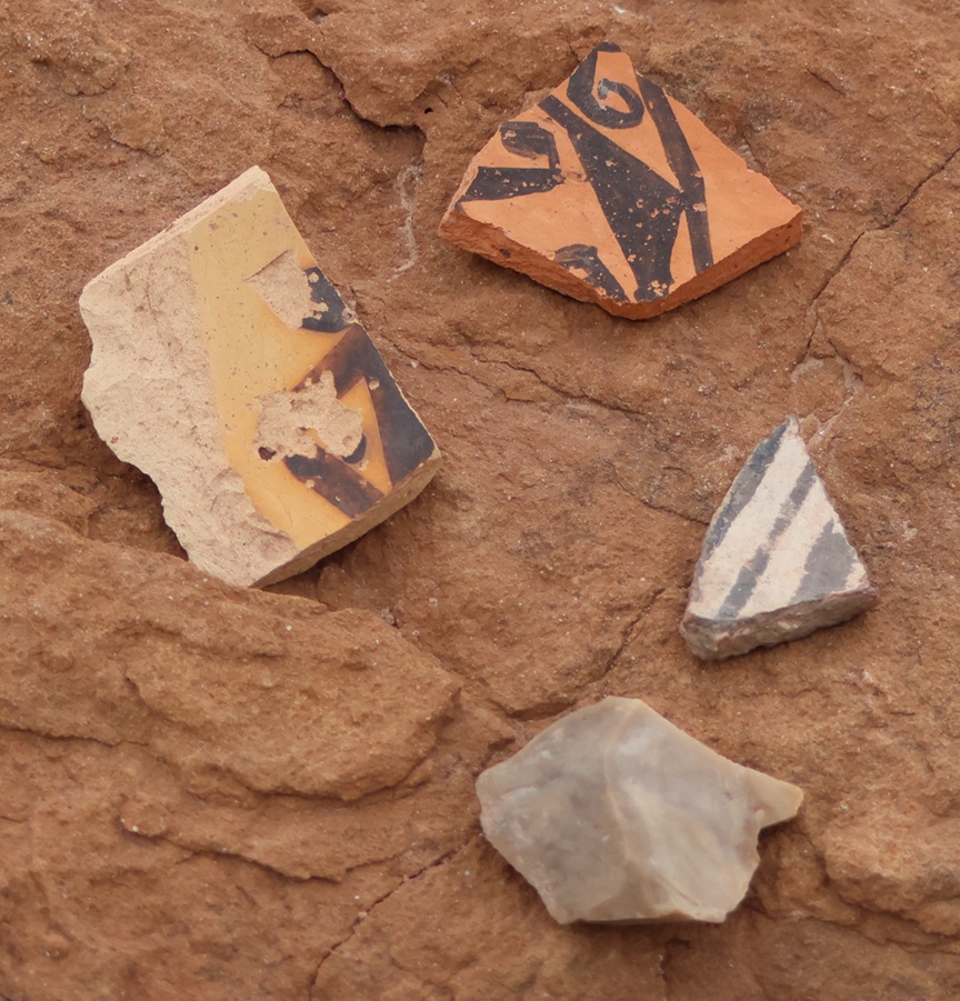
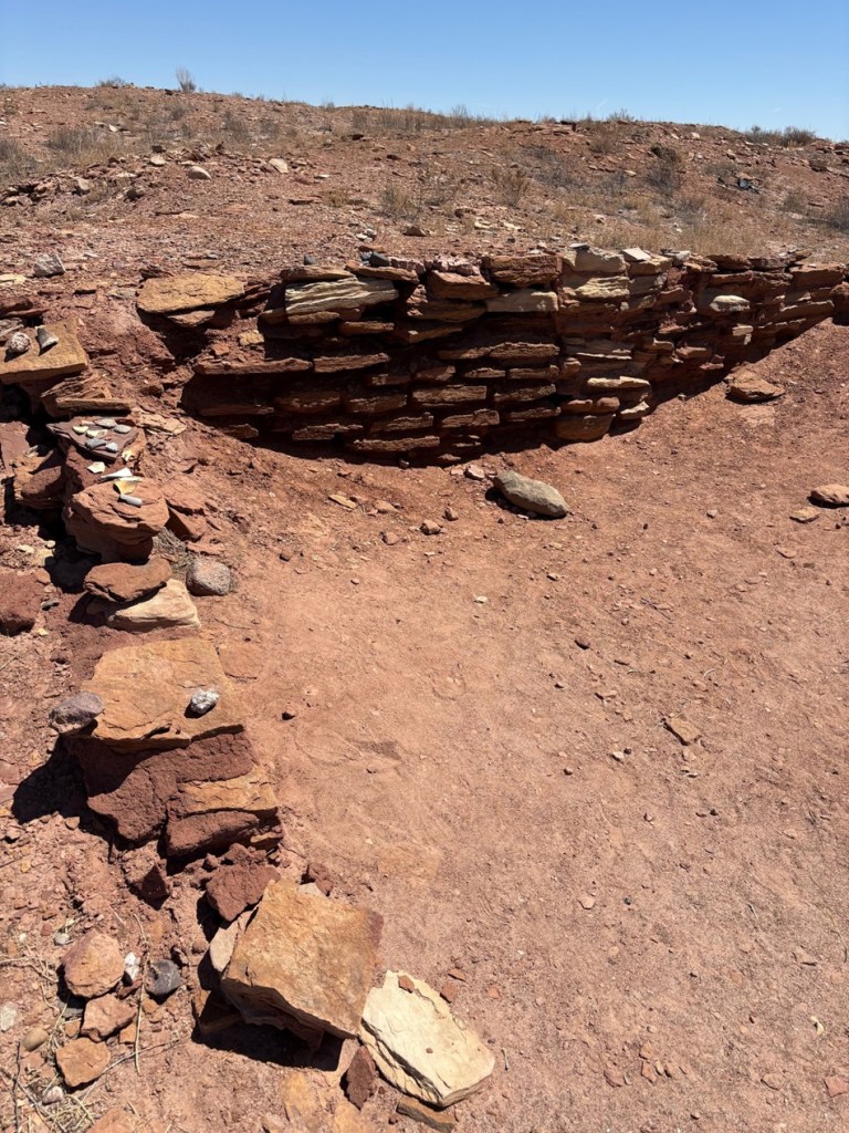
Much of Jerry’s museum collection was sold at public auction, so the two-headed calf and fossilized mammoth bones and most of the other items have found new homes all around the world (although word on the street is that there is an effort to retrieve some of the curiosities, but you didn’t hear that from me). One item that thankfully didn’t get spread to the four winds is this fine display of barbed wire, exhibited in the tower’s gift shop. Regular readers of this blog will know that I will spare no effort to post pictures of any worthy museum’s barbed wire exhibits and I’m rather unapologetic about it, so here you go.Fortunately, some of Jerry Chubbuck’s hand-painted museum signage, much of which identified the attraction’s many different rooms and warrens, was also withheld from the public auction and is now on display in the tower’s gift shop. I remember seeing some of these signs 40 years ago, and it was good to see them again.There were a lot of museum rooms (I want to say there were at least 20, but my memory may be faulty and it might have been more than that), and they all needed to be identified with signs. The sign at lower right, “Branding Room,” identified the room as containing the “Biggest Collection of Irons in the West.” I have no doubt that it was. Also of note: the signs announcing more than 20,000 “ancient arrowheads of this area” on display and “No Writing on Walls; Fine: $25.”This is a picture of a cover of one of History Colorado State Historical Fund’s annual reports, showing progress of the World’s Wonder View Tower restoration. The project, heavily financed by grants from the state’s historical fund but also with significant contributions from other donors from all around the state and local area, needed more than $3 million in funds for completion. See 6 States LLC and Friends of The Genoa Tower have some really exciting plans for the property, including its usage as an art gallery space and a venue for event functions. The property celebrated its grand reopening in early May of this year. From the standpoint of someone who visited it back in the day and then again this spring, it’s a very impressive transformation that has some great possibilities in front of it.Despite the threat of a $25 fine, many miscreants decided to leave graffiti on the tower’s walls as they ascended to the top. See 6 States LLC, in restoring the tower, made the right choice to leave the graffiti in situ while putting another coat of paint on the walls. This photo was taken from one of the tower’s staircases, looking southwest through a historic window.The United States Coast & Geodetic Survey placed this geodetic marker in the floor of one of the tower’s upper rooms in the 1930s, confirming the latitude, longitude, and, most importantly, the elevation of the World’s Wonder View Tower. Note the name “LeBow” (as in Myrtle) and the year, 1934, in the center of the disk. The USC&GS existed from 1807 until 1970, when it and several other government agencies became part of the National Oceanic and Atmospheric Administration (NOAA). People who hike a lot may have seen these markers on trails, used to compile accurate survey information with exact latitudinal, longitudinal, and elevation points on the surface of the Earth. This was the first one I’d seen that was about 50 feet off the surface of the Earth.The government surveyors used this wooden tripod, which they assembled in the tower room containing the geodetic marker, to precisely place the metal disk in the floor of the tower room in 1934. After the project’s completion, they attempted to take the tripod back down the tower’s stairs, only to find that the tripod’s legs were too wide to be transported down the narrow staircases. So, here it has stood for nearly a century, getting a new coat of paint every now and then.When I was a boy, the staircases in the tower, especially this final one leading to the viewing platform at the very top, could charitably be called “rickety.” See Six States LLC reinforced all of the staircases during the redevelopment, and the climb to the top and the viewing platform are rock-steady now. Happily, the group elected to keep the time-worn steps themselves; one wonders how many shoes have been on these steps in the last near-century. Those are Nancy’s shoes at the top of the photo; she and I had been at the top of the tower together a short time after we met when the Genoa Tower was still under the stewardship of Jerry Chubbuck, so she’s a seasoned veteran of the climb. Are you ready to discover what being at the top of the World’s Wonder View Tower looks like? Just follow Nancy!Taken from the top of the World’s Wonder View Tower, this viewpoint looking east-northeast shows the town of Genoa and then (“technically”) the states of Kansas and Nebraska beyond. Genoa’s water tower and grain elevator, both of which are predated by, and taller than, the World’s Wonder View Tower but you probably aren’t allowed to climb to the their respective tops, can be seen in center-right. You’d think that Genoa, Colorado, would be pronounced the same as the city in Italy (“JEN-oh-uh”). You’d be wrong: it’s pronounced “jen-OH-uh.” Now you know and can impress your friends with your newly acquired worldly knowledge, which, come to think of it, I probably should have shared before nearing the end of this posting.This perspective from the top of the World’s Wonder View Tower is looking directly south. On the other side of the cedar trees is Interstate 70, then about 20,000 square miles of Colorado farm- and ranchland, then (“technically”) New Mexico. It was a little hazy on the day of our visit, but the views were still really spectacular.This is a view from the top of the tower looking to the southeast. That’s again Interstate 70 near the horizon and (“technically”) Kansas beyond. Being 65 feet above the ground gives an interesting perspective to your surroundings, such as seeing some parts of the landscape under the darkness of cloud cover. The red roofs are the historic buildings of the World’s Wonder View Tower, where the café and overnight guest rooms, and later Jerry Chubbuck’s museum, were located. Just above them is the back side of the white-and-red “See 6 States” façade shown earlier. The white Ford F-350 Super Duty is Ol’ Blue, the Goddard’s six-wheeled towing unit. Just visible above the tree to the left of Ol’ Blue is a small travel trailer. That’s our first camping trailer, the predecessor to The Goddard, which we called “The Riglet” because bigger camping trailers and motor homes are sometimes called “rigs.” The Riglet is now owned by our friends Mary and Robert, whose company we enjoyed at the World’s Wonder View Tower and then they joined us in the Arriba campground in which we were staying for more fellowship.One last view from the top of the tower: this is looking northwest, so Denver is presumably somewhere on the horizon. There’s a radio tower on the horizon just left of center and most of the rest of the tall structures are wind turbines. The dependable winds available in eastern Colorado are quickly making the area an important location for renewable energy generation. The railroad bed and rails, still in use today, can be seen in the center of the picture, and just to the right of the tree in lower center is a dirt road that is the remnant of the old U.S. Highway 24 which, until the completion of Interstate 70 in the 1970s, brought people by the tens of thousands to the World’s Wonder View Tower. Goodbye until we see each other again, World’s Wonder View Tower! I look forward to seeing what your next hundred years will bring.
Located just seven miles south of Albuquerque, Valle de Oro National Wildlife Refuge (NWR) was established in 2014 as the first urban NWR in the American Southwest. One of nearly 600 national wildlife refuges in the United States, Valle de Oro is adjacent to Rio Grande Valley New Mexico State Park, which is next to the Rio Grande (there’s no “River” after the name because “rio grande” means “big river” in Spanish, so it’d be like writing “big river river”). Through the National Wildlife Refuge System, a number of different ecosystems, including wetlands, prairies, forests, and coastal areas, are protected from development in order to provide habitats in which wildlife and plants can thrive.
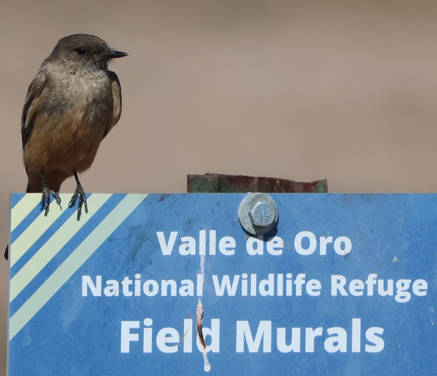
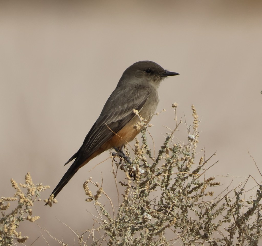
This Say’s phoebe welcomed us to the start of a hike at the refuge called the Valle de Oro Bosque Loop. “Bosque” (pr. boss-KAY) is Spanish for “forest,” and it refers to the many trees, mostly cottonwood, that line the banks of the Rio Grande just on the other side of the refuge’s western boundary.
In the case of Valle de Oro NWR, the refuge isn’t protecting undisturbed habitat that’s threatened by commercial development but rather restoring natural habitat from a formerly developed state.
This is near the trailhead of the Valle de Oro Bosque Loop. The Rio Grande doesn’t pass through Valle de Oro NWR, but rather on the western side of the refuge. You can probably tell, from the cottonwoods on the horizon, where the water from the river regularly reaches.
Because of the ongoing drought in the American Southwest, the Rio Grande can’t even realistically be called “big”; while we were in Albuquerque in May, the river was barely a trickle as it ran through the city. When not impounded and when historically normal moisture is available, the Rio Grande flows 1,896 miles from its headwaters in southwestern Colorado, through New Mexico, forms the southern border of Texas, and empties into the Gulf of Mexico. The Rio Grande is the fourth-longest river in the United States.
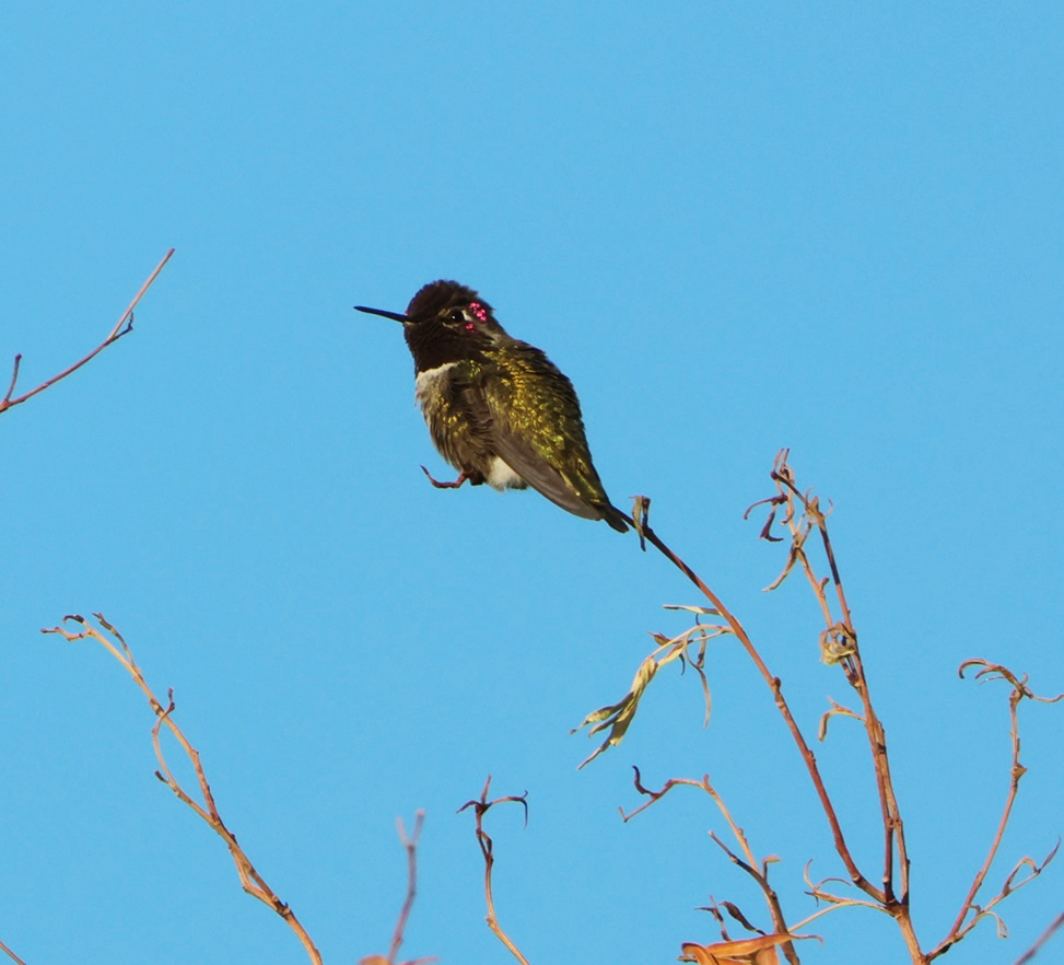
This black-chinned hummingbird (Archilochus alexandri) was making itself more comfortable on a perch just outside the front door of the refuge’s visitor center. The average heartrate of these little birds is 480 beats per minute, and in cold weather they may eat three times their body weight in flower nectar per day. They have body lengths of 3.5 inches (9 cm), weigh 0.1-0.2 ounces (2.3-4.6 g), and their wingspans measure 4.3 inches (11 cm). For comparison, a United States nickel minted in 1965 or later weighs 0.176 ounces (5 g). In good habitats, like along a river, a black-chinned hummingbird nest may be found every 100 yards (91 m) or so; their eggs are the size of coffee beans. Male black-chinned hummingbirds have a really vibrant swath of iridescent purple feathers on their chins, but those only appear when the sun hits them just right.
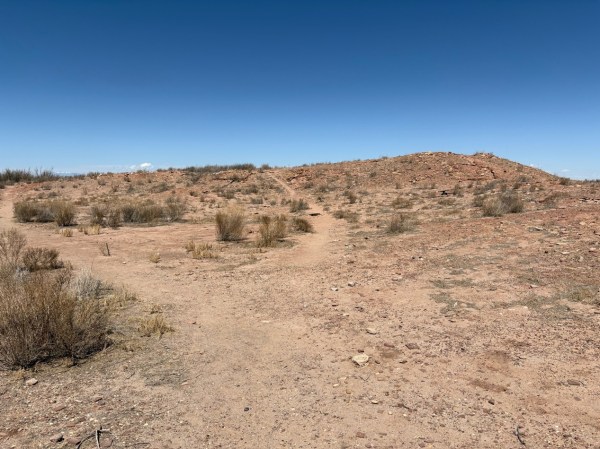
The 570-acre (just under one square mile) protected area now known as Valle de Oro NWR has a long and interesting history going back many centuries, and counts Pueblo Native Americans, Spanish conquistadors, and dairy and alfalfa farmers as those who have used its resources.
Valle de Oro NWR is among the ancestral and current lands of the Tiwa People, a Pueblo culture of Native Americans in what is now the Albuquerque area. Some of the Tiwa currently live in the Isleta and Sandia pueblos, two of New Mexico’s 19 Native American pueblos. The Pueblo culture initially developed between the years 700 and 1100, and particularly thrived between 1100 and 1300. Both Isleta and Sandia were established as pueblos in the 14th century; they were known by their Tiwa names until the Spanish arrived in the area in the late 15th century. “Isleta” and “sandia” are Spanish for “little island” and “watermelon,” respectively (more on “sandia” further down).
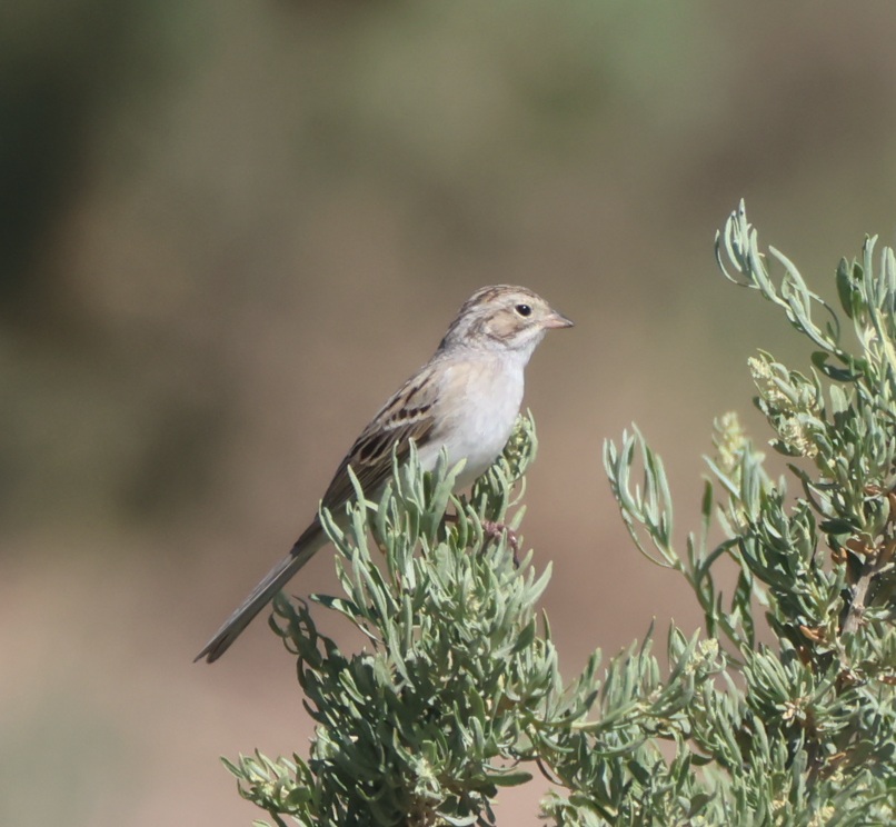
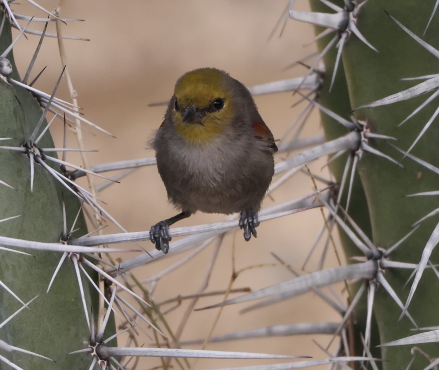
Nancy’s very good at spotting birds in the wild, and she pointed out a pair of these Brewer’s sparrows (Spizella breweri) that were perched at least 50 yards away on a sagebrush. Their size differs depending on their regional habitats, but in general Brewer’s sparrows are the smallest sparrows in North America with weights of 0.4-0.5 ounces (11-14 g). Because of a lack of defining coloration, markings, or other identification characteristics, these sparrows show why birding enthusiasts came up with the acronym of “LBB” for “little brown bird,” to serve as a temporary moniker of an individual bird until positive identification can be made.
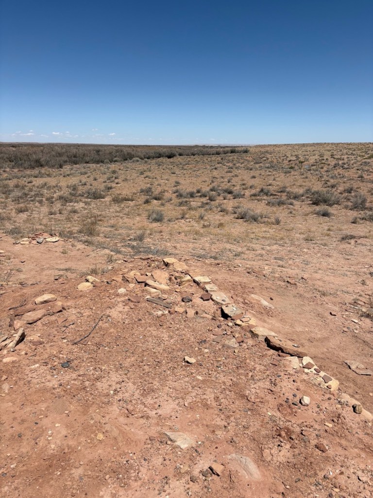
The Spanish established a major road, El Camino Real de Tierra Adentro (“the royal road of the interior land”), that extended 1,590 miles (2,560 km) from Mexico City to just north of Santa Fe in present-day New Mexico. The road, one of four that connected Mexico City to the resources of the vast Spanish colony in America, was used from 1598 to 1882 to transport soldiers and trade goods. Much of El Camino Real still exists in the form of state highways and county roads (it passes right by one of our favorite restaurants in Las Cruces), and, back up near Albuquerque, it forms the eastern border of what is now Valle de Oro NWR.
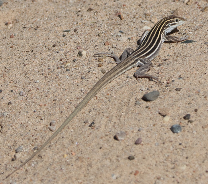
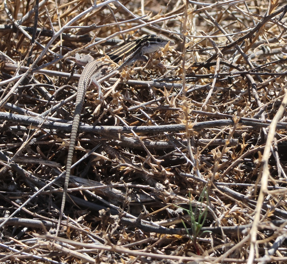
THIS IS A TALES OF THE GODDARD LIZARD ALERT. Desert grassland whiptail lizards (Aspidoscelis uniparens) live along the Rio Grande in New Mexico and in southern to central Arizona, as well as in northern Mexico. Their tails are longer than their bodies, which measure 2 3/4 to 5 1/4 inches (7.0-13.3 cm) long. They are easily identified by the six yellow stripes extending from the head and along the body. Desert grassland whiptails eat a variety of insects and other invertebrates, including ants, termites, beetles, butterflies, and grasshoppers.
Time passed, and, when Mexico gained its independence from Spain in 1821, Albuquerque changed from a New Spain outpost into a Mexican city. Albuquerque and the rest of the American Southwest became part of the United States in the mid-19th century and, in the 1930s, a family with a dairy in El Paso, Texas, expanded their operations to include a tract of land near Albuquerque. The family named the dairy “Valley Gold,” which you might, and correctly, infer (roughly) translates in Spanish to “valle de oro.” Following an increased demand for milk in the southwest after World War II, Valley Gold expanded its herd to 1,600 cows, making it one of the largest privately owned dairies in the country. The U.S. Department of Agriculture records that an average dairy cow in 1950 produced 5,300 pounds of milk each year (in 2025, an average dairy cow produced 24,400 pounds of milk annually; the industry has certainly gained some efficiencies). Anyway, dairies use a lot of water, so the Valley Gold operation developed substantial irrigation infrastructure using water from the nearby Rio Grande.
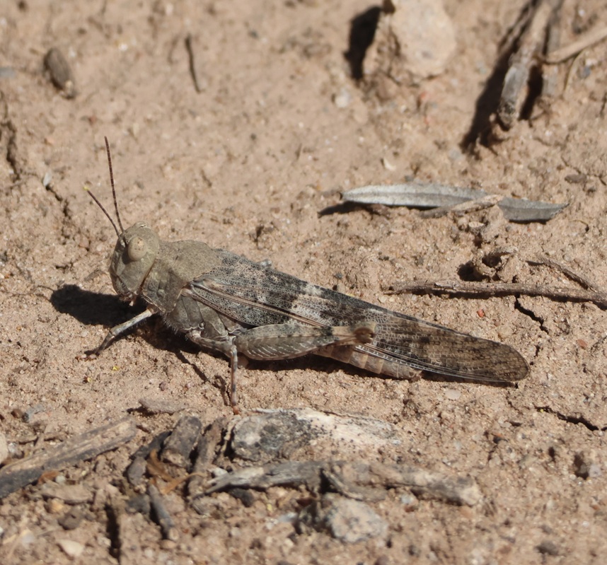
There were quite a few grasshoppers jumping about the trail as we walked. This is a pallid-winged grasshopper (Trimerotropis pallidipennis), a species common in the American Southwest. They grow to a length of 1 1/2 inches (37 mm), and their pale coloration makes for good camouflage in the dry riverbeds that they frequent.
Valley Gold ceased operations in the Albuquerque area in the late 1970s, and the property operated as an alfalfa farm (which also required a lot of water) for some time until the land was put up for sale and probable commercial development. A group of residents in the area formed Friends of Valle de Oro, a nonprofit organization that raised $9 million to buy the property and then partnered with the U.S. Fish & Wildlife Service to create the southwest’s first urban national wildlife refuge. What had been home to Pima People, part of the route from Mexico City to Santa Fe, then a dairy and alfalfa farm, was now ready to welcome back dozens of species of birds, mammals, and other wildlife to an area protected from commercial development.
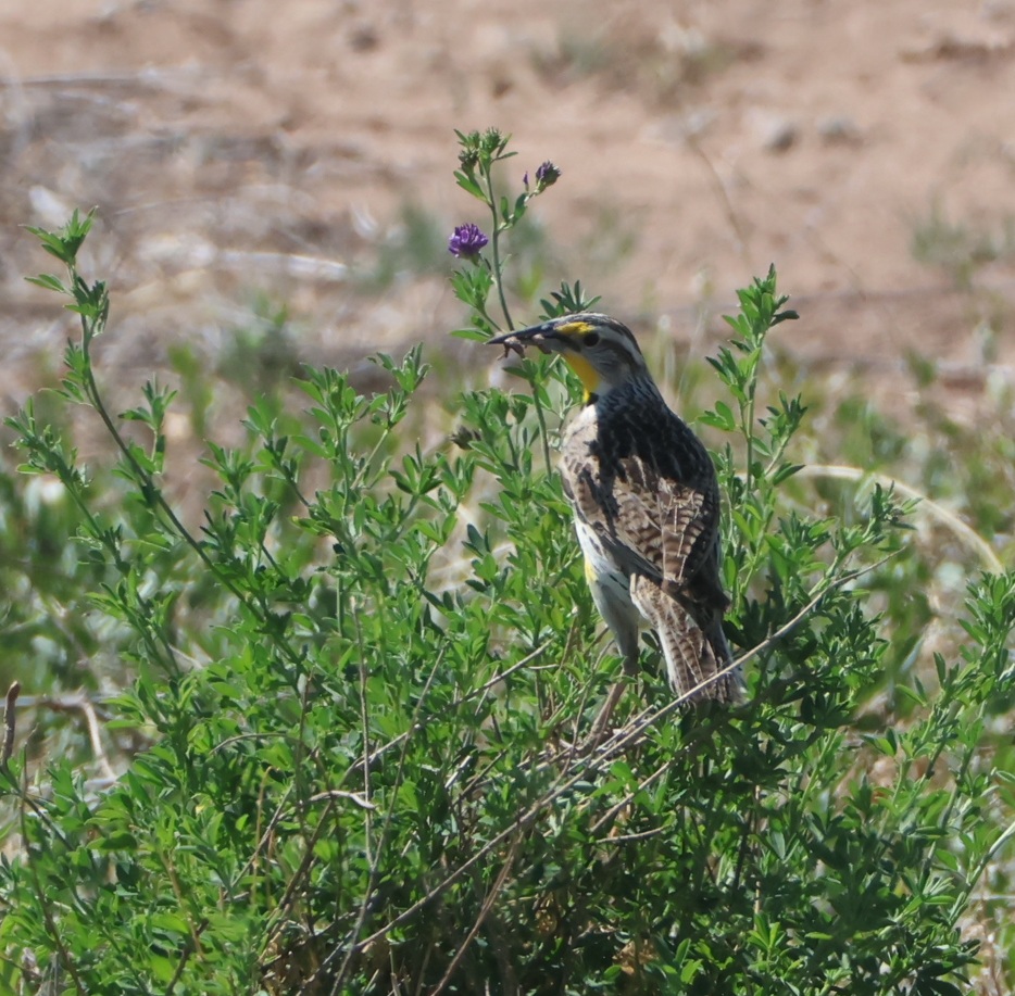
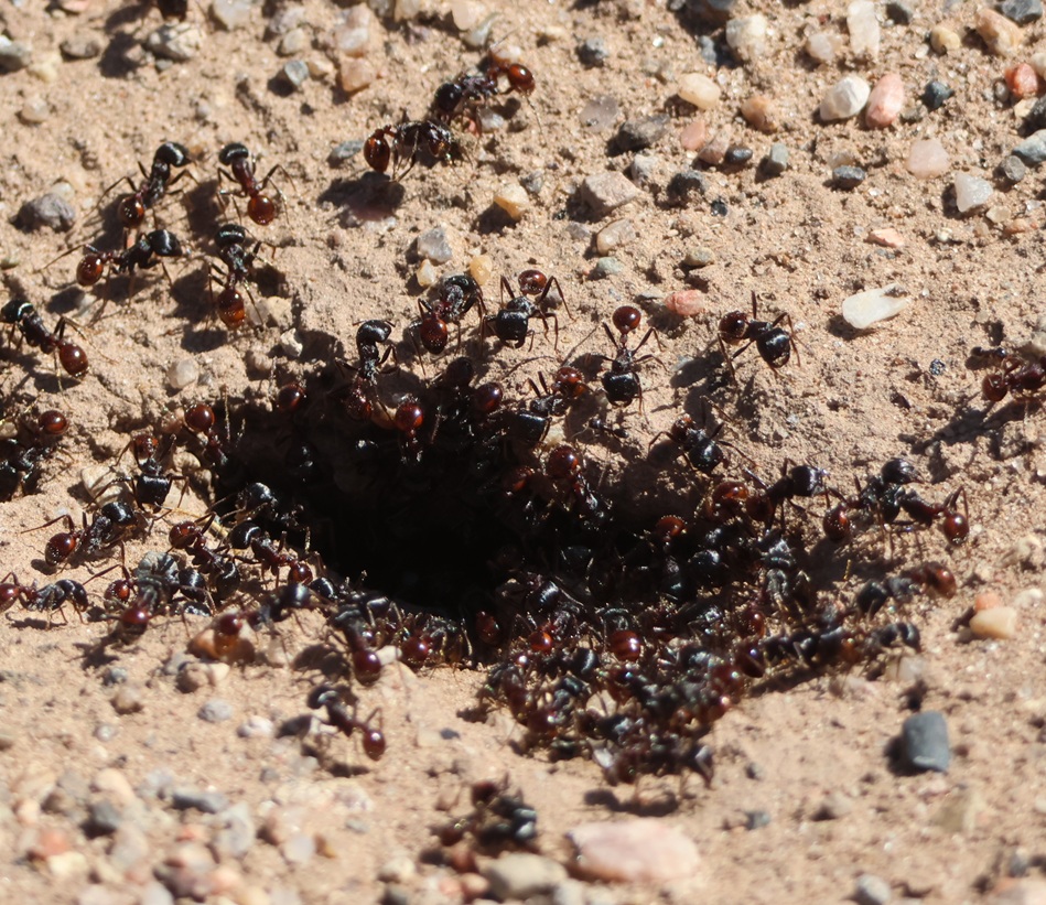
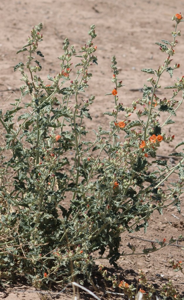
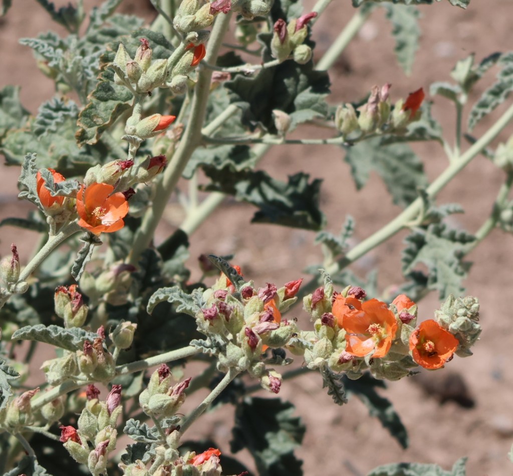
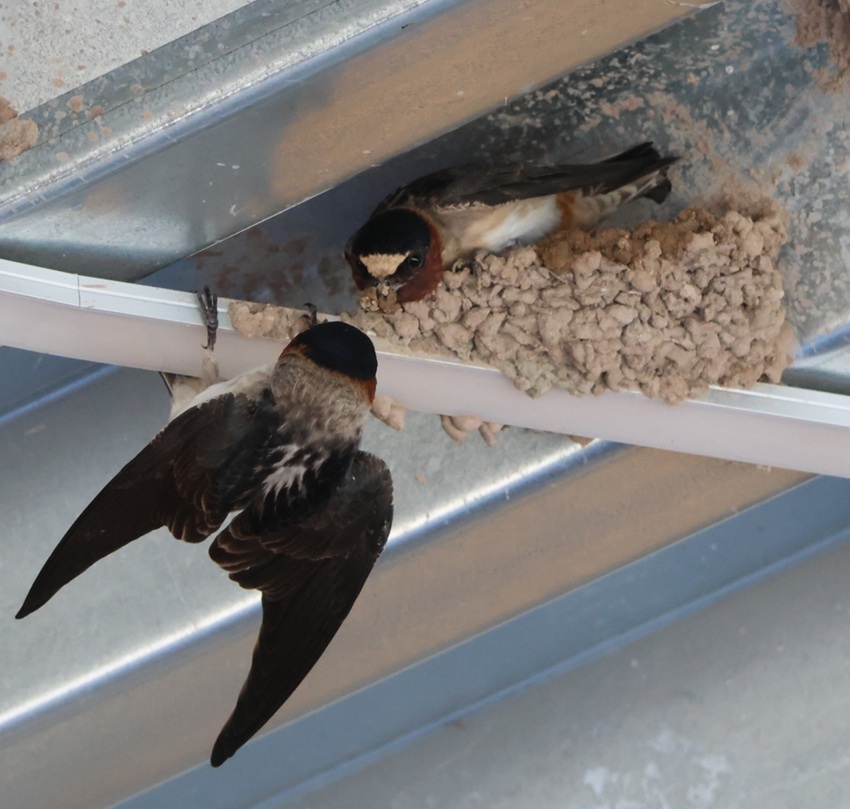
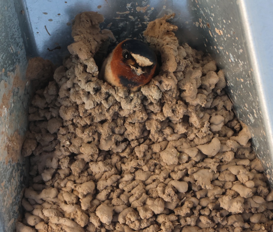
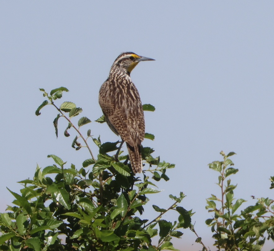
Here’s a photo of another grasshopper; this one finds itself in the unfortunate position of being in the beak of a western meadowlark (Sturnella neglecta). No less a naturalist than John James Audubon gave this bird its scientific name: “sturnella” means “starling-like,” and “neglecta” refers to Audubon’s belief that this species was overlooked by 19th-century ornitholgists. The plant on which the meadowlark is perched points to the refuge’s past: it’s alfalfa, which, due to its high protein content, comprises up to 50 percent of a dairy cow’s diet. Although the irrigation systems that served the dairy and alfalfa farms that once occupied this land are long out of use (the canals are filled with blown dirt and sand), some alfalfa plants still found enough water to thrive and bloom.THIS IS ANOTHER TALES OF THE GODDARD LIZARD ALERT and it’s another desert grassland whiptail. They’re well-camouflaged in dry desert brush like this. Albuquerque is at the northern edge of the Chihuahuan Desert, and here was a reminder that deserts have lots of sharp things like cactus thorns and ant mandibles. At one point on the trail, we stopped because Nancy had seen a bird drop from a low branch onto the ground and was attempting to spot it. I told her not to back up. lest she step into this. It’s a colony of desert harvester ants (Pogonomyrmex rugosus), which have powerful jaws and very painful venomous bites. These ants use pheromones to create invisible trails that enable other ants to follow to the colony, bringing with them plant seeds and dead insects. A few minutes before, I noticed a couple of small leaves moving on the trail in the same direction we were walking even though there wasn’t a breeze. The leaves were being carried by two harvester ants, presumably from this colony. We left the colony and continued on the trail without incident.Here’s Gunther, who enjoyed the walk with us, and here’s what much of the terrain of the Valley de Oro Bosque Loop looks like, at least away from the parts connected to the Rio Grande. Because it was used for so many decades as a dairy and later an alfalfa farm, there aren’t as many native plants as there are in other parts of the desert around Albuquerque – when water stopped being diverted from the Rio Grande, the land essentially dried up. Volunteers and NWR staff are hard at work changing that, with plantings of trees and other native plants. The buildings just this side of the mountains are in Albuquerque, and the mountains themselves are the Sandias. They rise to a top elevation of 10,678 feet (3,255 m) and are New Mexico’s most-visited mountain range. Spanish explorers gave the mountain range the name “sandia” because they seem to glow pinkish-red, like a watermelon, during Albuquerque sunsets.The mission of the National Wildlife Refuge System is “To administer a national network of lands and waters for the conservation, management, and where appropriate, restoration of fish, wildlife, and plant resources and their habitats within the United States for the benefit of the present and future generations of Americans.” Here’s an example of the plant resources: desert globemallow. Its coral-colored flowers are an extremely familiar sight to anyone in the desert southwest. I remember on a drive to the north rim of the Grand Canyon in north-central Arizona a couple of years ago, we saw millions (maybe an exaggeration, maybe not).Even though it’s very, very common, I always like seeing desert globemallow (Sphaeralcea ambigua) while we’re in the southwestern United States. Its blooms are just gorgeous, and they support the larval stages of at least five different pollinating buttterflies. The plants grow to a height of 3 feet (just under a meter), with a spread of 2-3 feet (0.6-0.9 meters). I’m writing this blog posting from our campsite in Santa Fe, New Mexico, a few days after our visit to Valle de Oro National Wildlife Refuge, and there are (very short) desert globemallow plants growing outside the Goddard.These are cliff swallows (Petrochelidon pyrrhonota) working together to build their mud nest under the roof of the refuge’s visitor center. Nancy and I estimated that there were several hundred of these swallows flitting about the visitor center and constructing their nests for the spring. These birds eat all kinds of flying insects and they are themselves incredibly skilled aerialists; I took about 50 pictures of swallows in flight at Valle de Oro and none of them turned out well because the birds were flying and turning so quickly. A staff person told Nancy that swallows lived in the huge dairy barn that used to be at the refuge, and they’ve adapted to using the new visitor center for nesting.This nest appears to be nearly complete. Each nest is built from 900 to 1,200 mud pellets, with walls that are about 1/2-inch thick. A cliff swallow clutch can include between one and six eggs, and a female swallow may lay one or two clutches during the breeding season. Cliff swallows nest near bodies of water, which provide mud for nests as well as insect habitat. Most cliff swallow colonies contain between 200 and 1,000 nests, although there’s a colony in Nebraska with 3,700 nests. It strains the mind to think about how many flying insects are needed to feed all of those birds every day. Here’s another western meadowlark that was perched about 50 yards from the refuge’s parking lot, with a link to an audio file of a western meadowlark’s call:
Whenever I hear that wonderful call, I’m reminded of meadowlarks that I used to listen to at the Denver-area office of one of my previous jobs. The parcel adjacent to the office was less than an acre but still unbroken prairieland, and it attracted quite a lot of wildlife including western meadowlarks. I enjoyed listening to them in the spring and summer months from the parking lot of my office, until construction began on that lot and it became another parking lot and commercial building. I remember being frustrated at the meadowlarks losing their habitat, and I also remember later realizing that the parking lot and building of my office was once wildlife habitat as well.
That’s the primary reason that the National Wildlife Refuge System exists: to protect wildlife habitats from development, or, in the case of Valle de Oro National Wildlife Refuge, to return commercially developed properties back into their native habitats. The Tiwa culture, the original inhabitants of this area in what is now central New Mexico, continue to play a major role in how Valle de Oro National Wildlife Refuge is managed and protected. I’m happy that’s the case.
We’ve just made our retreat from winter quarters in Las Vegas, Nevada, and now, in the first week of March 2026, find ourselves in Kingman, Arizona – just 100 miles down the road. I’ve written before about the many reasons we spend the winter months in Las Vegas, but it mostly comes down to these two:
The warmer temperatures of the Mohave Desert make the winter months both more comfortable and more practical. Cold-weather campers who stay in truck campers, travel trailers, and fifth-wheels like The Goddard know that it’s a pain – a necessary one, but still a pain – to disconnect water supplies from your RV if the temperature drops much below freezing. It’s critical to keep your water hoses, valves, and other equipment from breaking because of the frozen-water expansion. In three years totaling more than 12 months in Las Vegas, we had to disconnect from the water supply five times, and at least two of those were out of an abundance of caution.
If you run out of things to do in the literal Entertainment Capital of the World, that’s kind of on you.
There are other reasons, too, of course: frequent departures and arrivals from and to Harry Reid International Airport, through which 58.5 million people passed in 2024, allows for plenty of flights to see friends and family, there are restaurants featuring pretty much any kind of cuisine in the world, and (maybe this should be in the bullet list above) there are birding opportunities a-plenty.
Nancy and I had been to Las Vegas many times prior to selling our home in Denver and becoming full-time RVers, but our experiences in the city were pretty much limited to flying in to the airport, being transported to a hotel/casino, being entertained, and then being transported back to the airport so we could return to Denver. Having the opportunity to effectively live in Las Vegas for a quarter of the year gives us a much different perspective: people actually live, work, and raise families there – did you know that? Buying groceries, having your vehicle’s tires rotated, going to a park to escape the city noise: all of the things that people do every day in other cities are done by Las Vegans every day.
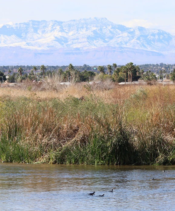
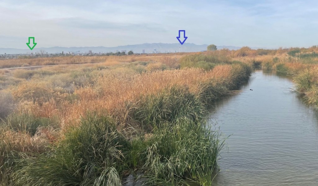
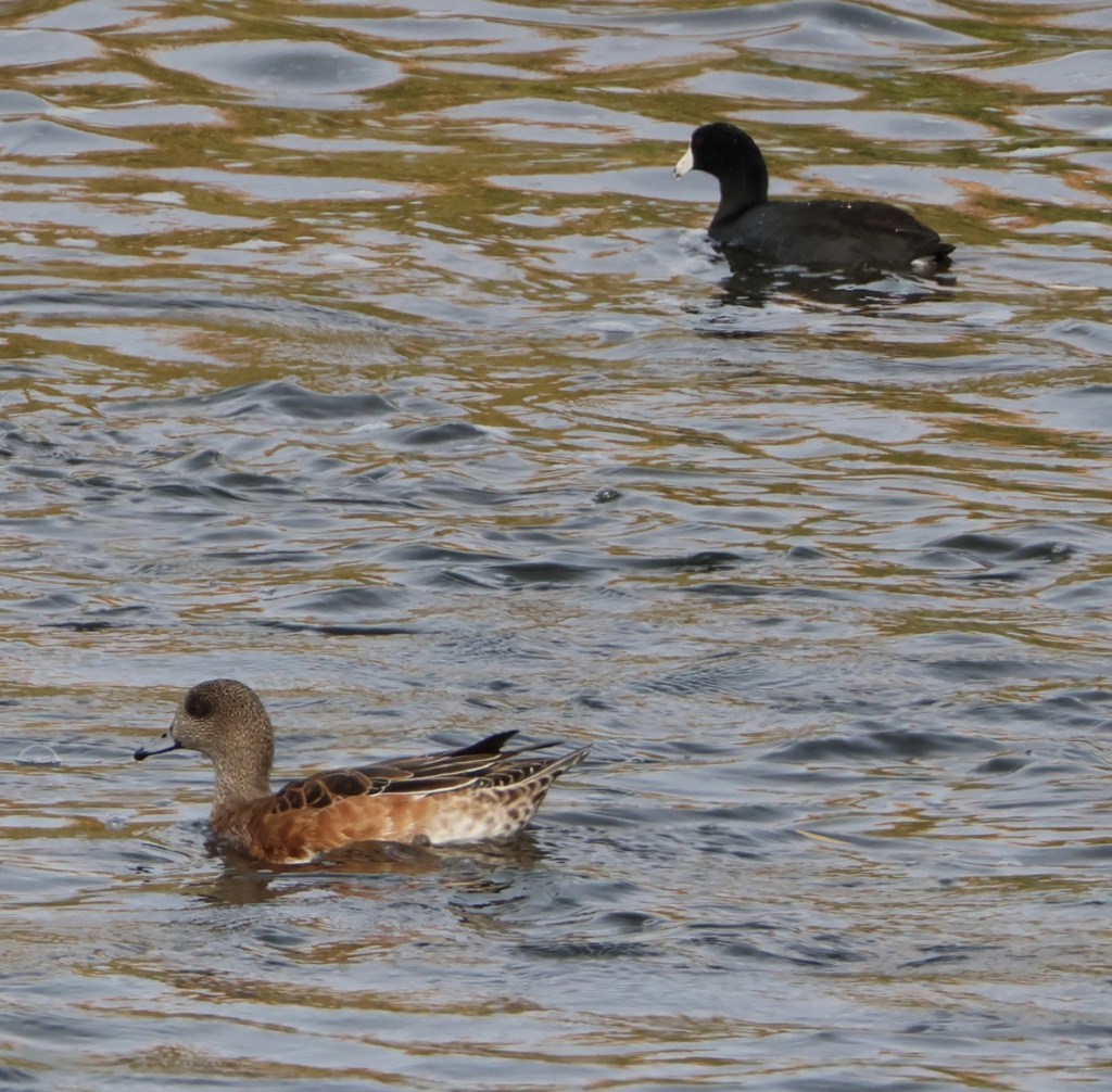
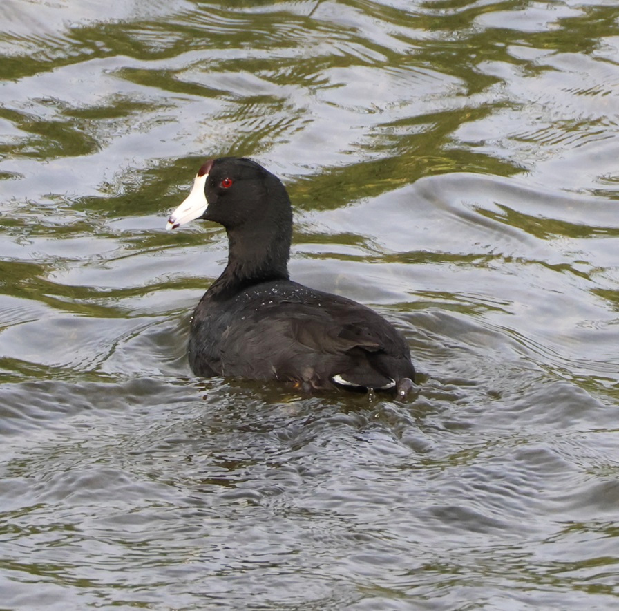
American coots swimming in the Las Vegas Wash were a familiar sight all four months we visited Clark County Wetlands Park. The city of Las Vegas (or, rather, the unincorporated towns of Paradise and Winchester; incorporated Las Vegas is itself a really small part of the metropolitan area) is on the other side of the tall grasses, and the snow-dusted mountains in the background, situated west of the metro area, show that it really was wintertime.
Maybe it’s not such a revelation to you, but, as someone who previously didn’t think about what people who actually live in Las Vegas do (you can’t make a living playing cards and going to shows, or at least not consistently), it certainly was to me.
Two of the places that we spend a lot of time while in Las Vegas are also home, or at least serve as a temporary stopover, to a number of different birds. I’ve written before about both Clark County Wetlands Park and the Springs Preserve, and they were once again sites to which we returned in the winter of 2025-2026.
I probably took about 500 pictures of birds over the winter (I’m not exaggerating), and here, in alphabetical common-name order, are 10 species that I really enjoyed watching (I enjoyed watching all of them and I didn’t get pictures of some that I really, really enjoyed watching, like an osprey hurtling into a stream in pursuit of a fish, or an American white pelican gliding over the desert).
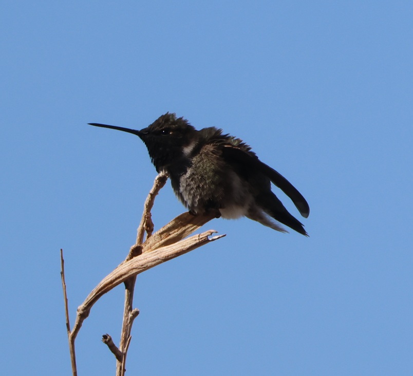
Anna’s hummingbird
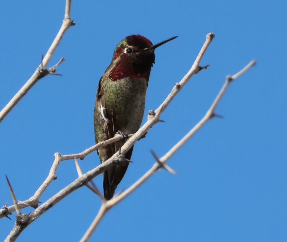
Primarily because of its warm climate, Las Vegas is a year-round home, or nearly so in some instances, to four different hummingbird species. The most common is the Anna’s hummingbird (Calypte anna). These little birds have a wingspan of 4.7 inches (12 cm) and weigh only up to 0.2 oz (5.7 g). Their bodies have the volume of a ping-pong ball and the mass of an American nickel. I took this picture at Springs Preserve on February 28 near the ciénega (Spanish for “swamp”), the manmade wetland feature that recreates the original water springs around which the original townsite of Las Vegas developed. Northern mockingbirds were by far the most common birds we saw at Springs Preserve, but we saw many Anna’s hummingbirds, as well as a couple of possible other hummingbird species, that day.
We’ve stayed at the same campground in the Las Vegas area the last three winters, and there’s a dog run there with a nearby tree that usually has an Anna’s hummingbird (not the one pictured, unless it decided to fly 11 miles to this different tree) perched at its top in the mornings. Seeing that little guy is always a great way to start the day.
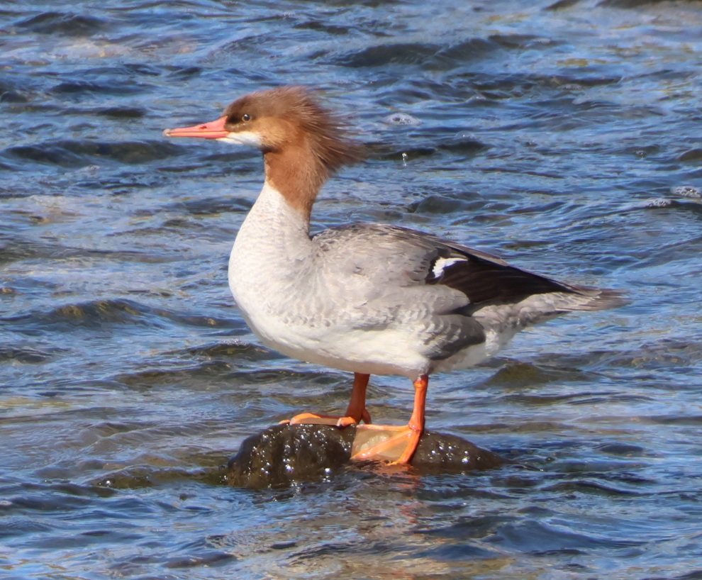
Common merganser
Nancy and I saw our first common merganser (Mergus merganser) two years ago in Pagosa Springs, Colorado, when one of these ladies (the drakes have dark-green head plumage) plopped down into the San Juan River flowing next to the restaurant at which we were dining al fresco. I got a really bad picture of it with my iPhone, but I could still tell that it was a common merganser (and a hen) because of the distinct reddish-brown head. We saw our second common merganser (another hen) paddling about the Yellowstone River during our first evening in Wyoming’s Yellowstone National Park last fall. This pretty lady pictured was one of five or six mergansers in the Las Vegas Wash on the morning of February 13. These birds have wingspans of 30-38 inches (78-97 cm) and weigh up to 4 pounds, 10 ounces (2.1 kg). All mergansers have serrated bills, which help them catch and hold on to fish. This species is found across the northern hemisphere at least part of the year; they are year-round residents of areas with ice-free water.
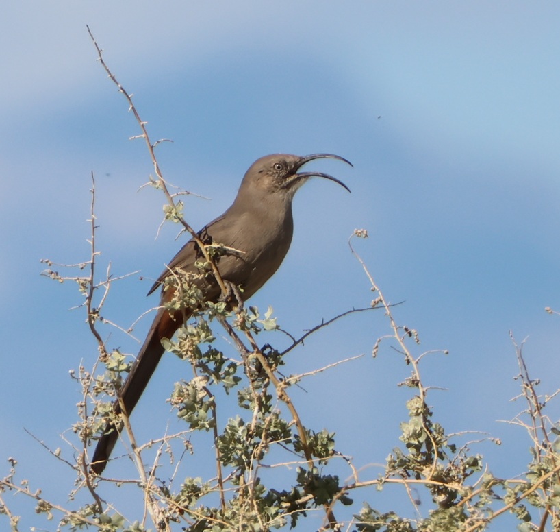
Crissal thrasher
I saw my first crissal thrasher (Toxostoma crissale) last winter at Clark County Wetlands Park, and I saw a few more there this winter; I’ve only seen them there. These birds have bodies ranging from 10.5 to 12.5 inches (27-32 cm). I’ve been a somewhat serious bird enthusiast for perhaps five years, and I’m still amazed at their diversity. Crissal thrashers’ beaks evolved into this shape to allow them to capture insects in the leaf litter at the bases of trees and shrubs. Compare this thrasher’s beak and its diet with those of the merganser (which eats fish) and hummingbird (primarily flower nectar) above. A different thrasher species, Toxostoma curvirostre, has the common name of curve-billed thrasher (we’ve seen them in Arizona and New Mexico); its bill is indeed curved, but not nearly as much as that of a crissal’s. Inexplicably, my copy of the National Audubon Society’s Field Guide to Birds has a photo of the crissal thrasher facing the camera, so the effect of that wondrous bill is completely lost.
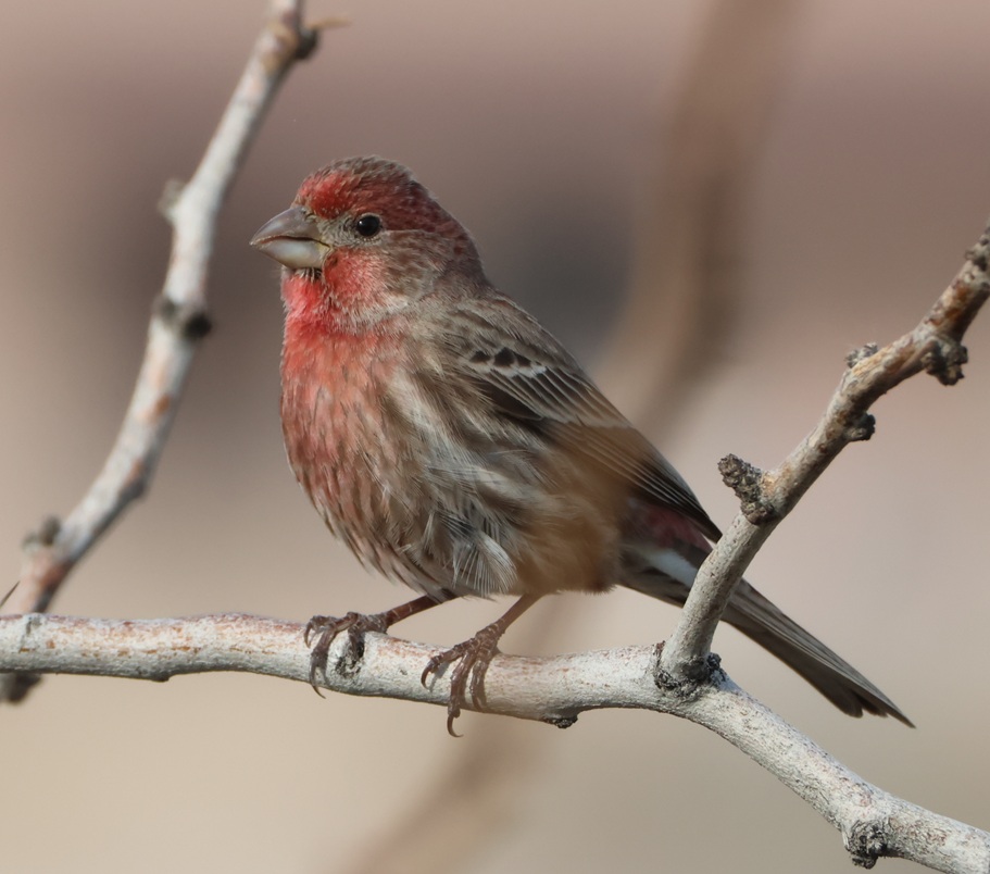
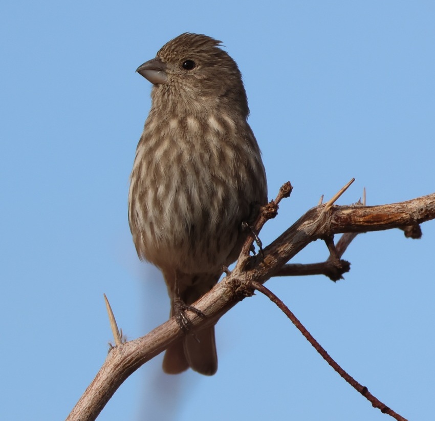
House finch
Continuing the comparisons of birds’ beaks and what they eat, have a look at these male (top) and female house finches (Haemorhous mexicanus) I photographed at Clark County Wetlands Park on January 7. For relatively small birds [5-6 inches (12.5-15 cm) in length, with an 8- to 10-inch (20-25 cm) wingspan], those are pretty stout beaks; they’ve evolved to crack open grains, nuts, and seeds with ease. Male house finches, as is the case with many (not all) birds, are more colorful than females; the red color comes from their diet. I’ve also seen orange- and yellow-colored male house finches; we saw a couple of orange ones at Springs Preserve in late February. House finches have very cherry calls and songs. As indicated by their scientific name, house finches are native to Mexico and the American Southwest. Populations were taken to the East Coast at the turn of the 20th century with the intention to be kept as house pets, but that was illegal so the owners let the birds into the wild and now the species is found over most of the United States.
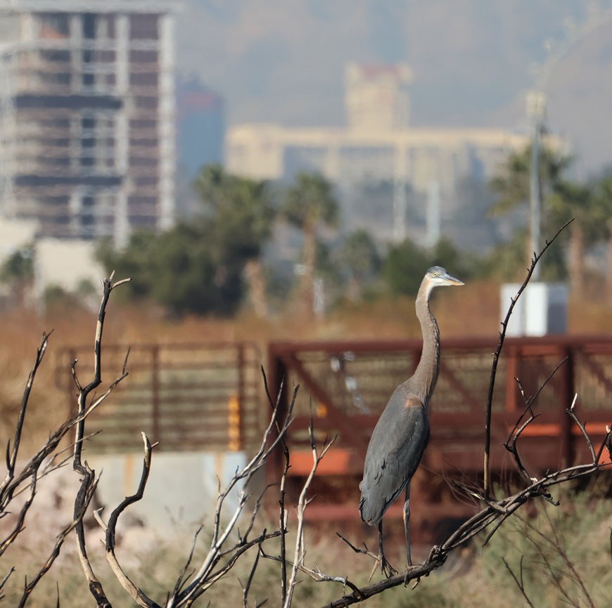
Great blue heron
They’re usually seen standing silently on the bank of a river or lake while hunting fish, but it’s not terribly unusual to see great blue herons (Ardea herodias) find a perch (a place to rest, not a type of fish) in a tree. This particular perch was perhaps 3 feet off the ground, so I don’t think that this 45- to 54-inch-tall (115-138 cm) bird found much advantage in this position, but I’m not one to question such decisions. These are the largest herons found in North America; their wingspans measure 66-79 inches (167-201 cm). Great blue herons are found from throughout Canada down through the United States, Mexico, and South America. They are an apex predator of wetlands, where their diet includes small mammals, reptiles, and invertebrates, in addition to fish.
Some incidental notes about this photo: the brown railed structure in the background is part of the bridge that crosses the Las Vegas Wash. Most of the photos of ducks and other waterbirds in the river were taken from that bridge. The Las Vegas Wash (“wash” in the American Southwest refers to a usually intermittent riverbed) runs from the city all the way to Lake Mead about 30 miles downstream, transporting treated wastewater and runoff along the way. The water from Lake Mead finds its way back to Las Vegas via pumping stations and other infrastructure to be used again. At the top left corner is the Eastside Cannery, a 16-story hotel and casino at Boulder Highway and Nellis Boulevard, just south of the campground where we spend the winters. The 307-room property was built at a cost of $250 million and completed in 2008. The property was purchased by Boyd Gaming (owner and operator of many gaming properties around Las Vegas and the United States) in 2016. The Eastside Cannery casino and hotel closed due to COVID-19 in March 2020 and never reopened; it is set to be imploded two days from this writing (that is, on March 5, 2026).
And so it goes.
Not a bird
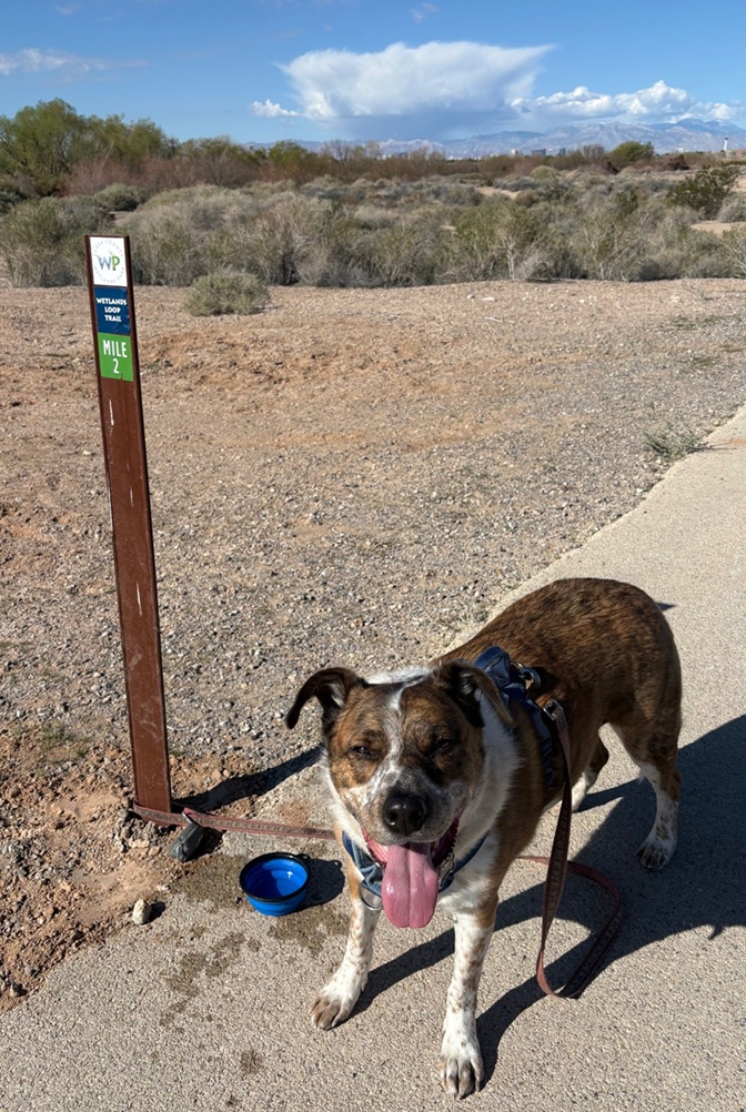
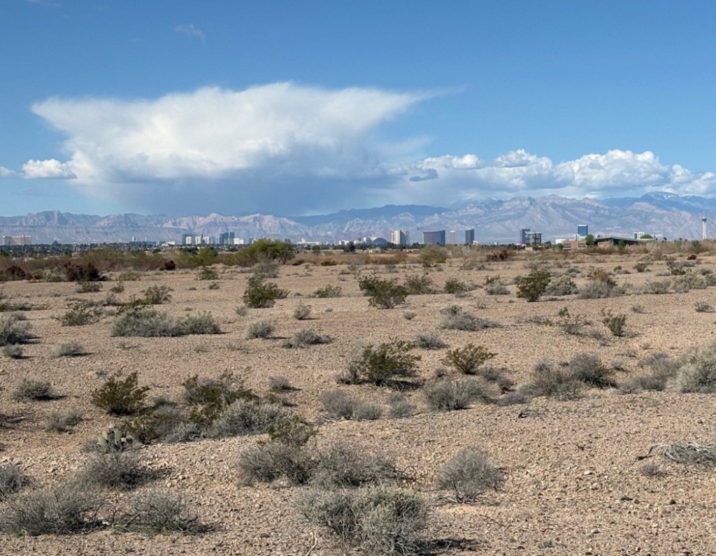
Halfway through – time for a water break! This is actually the halfway point on the Wetlands Loop Trail that Gunther and I enjoyed a couple of times this past winter. Gunther probably got at least as much water in him as he did on the sidewalk. The buildings just this side of the mountains are on Las Vegas Boulevard (“The Strip”); that’s the 1,149-foot-tall (350 m) white tower of The Strat (formerly The Stratosphere) at the right edge of the photo. It is the tallest observation tower in the United States. Readers of a certain age will remember Vegas World, a property owned by Bob Stupak that opened in 1979; some of that casino and hotel was refurbished into The Stratosphere, which opened on April 30, 1996.Here’s another photo of The Strip, taken a little later in our walk (notice the cumulonimbus cloud at left) and showing some of the Mohave Desert terrain typical of Clark County Wetlands Park when you’re not next to the water provided by the Las Vegas Wash. This viewpoint is about 10 miles east of The Strip. The white tower of The Strat is at far right; the beige Mandalay Bay is at far left (the pyramid of the Luxor Hotel & Casino is just to Mandalay Bay’s right) and about five miles south of The Strat. All of the other Strip properties, like Caesar’s Palace, Paris, The Bellagio, the MGM Grand Las Vegas, The Flamingo, The Wynn – there are 30 in all – are in between. Incidentally, the biggest hotel on the strip, the MGM Grand Las Vegas, has 4,762 rooms – more than a third of the total number of hotel rooms in all of downtown Denver. Mandalay Bay is the southernmost large hotel and casino on The Strip; The Strat, five miles north, is located within the city limits of Las Vegas and therefore, according to Clark County, not technically on The Strip.
And so it still goes.
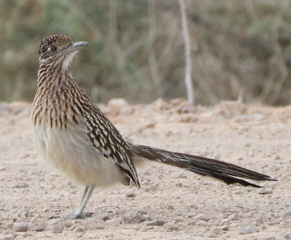
Greater roadrunner
Let’s get back to birds, with this photo I took on Jan. 23, 2026. One of the reasons I include the scientific names of birds in these postings is because they’re just fun to say. This is Geococcyx californianus, the “Californian earth-cuckoo.” The only other member of the Geococcyx genus is the Geococcyx velox (that, too, is fun to say), the lesser roadrunner, which is found only in Central America. Standing 9 3/4 to 11 3/4 inches (25-30 cm) tall, the greater roadrunner is the largest cuckoo on the American continent. Roadrunners have zygodactyl feet, meaning they have two toes in the front and two toes in the back of the foot [as opposed to most birds, which have three toes in the front and one toe in the back (anisodactyl)]. Osprey, too, are zygodactyl: the configuration allows them to carry their fish prey in the air facing forward, rather than side-to-side, for better aerodynamics. I saw this greater roadrunner while it was running on a road; it was great.
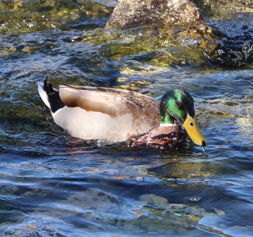
Mallard
Most readers will recognize this handsome fellow as a mallard (Anas platyrhynchos) which is one of the largest species of dabbling ducks, or ducks that feed mostly on the top of the water rather than diving down for their prey (like, say, a common merganser). Mallards are 20 to 26 inches (50-65 cm) long, with wingspans measuring 32 to 39 inches (81-98 cm). The drakes have these gorgeous green heads while hens have more restrained brown overall coloration. I’ve taken lots and lots of photos of ducks in general and mallards specifically over the last four or five years. I’ve never been as close as I was to this one when I took this on Feb. 13, 2026, from the Las Vegas Wash bridge. I’m happy with how this photo turned out. Look at that duck dabble!
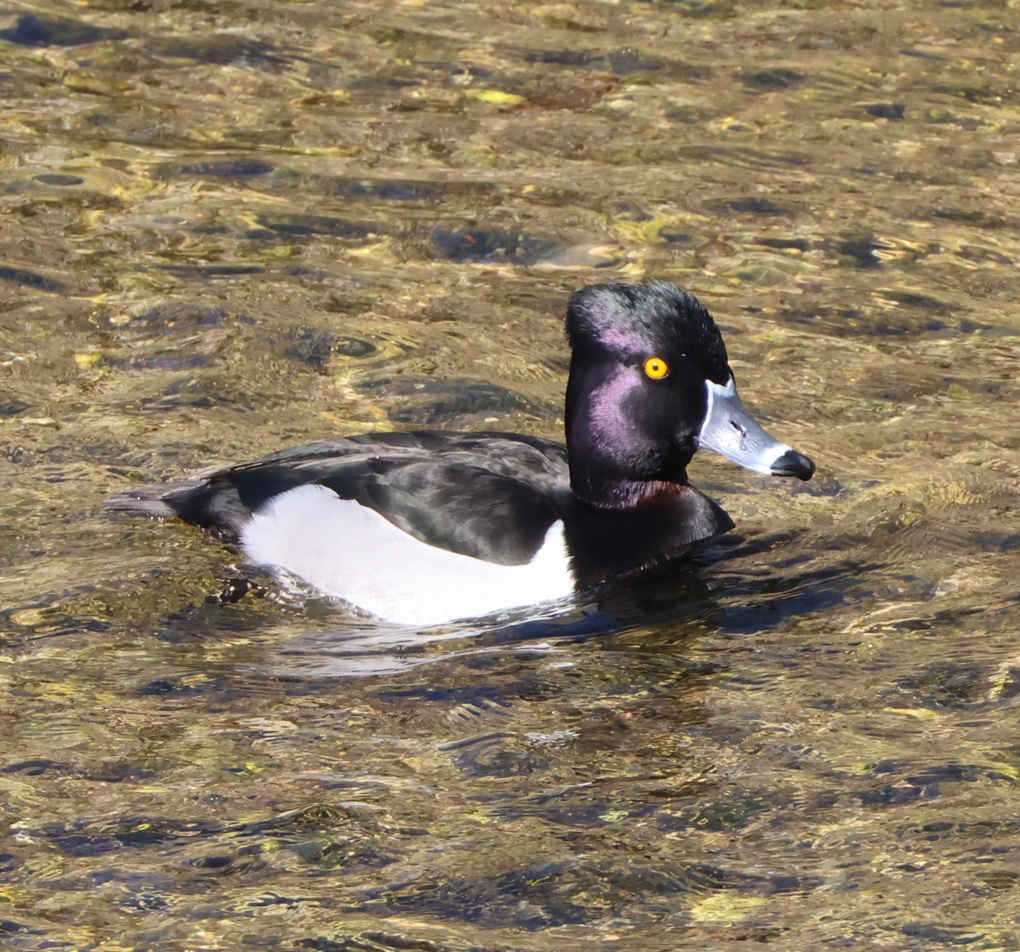
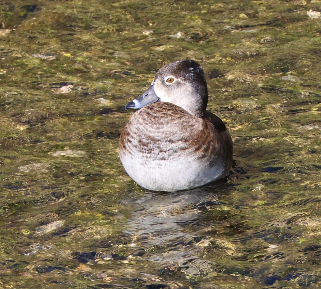
Ring-necked duck
Doubling down on ducks: these are ring-necked ducks (Aythya collaris), a drake (top) and a hen. This species is a diving duck, which, appearances aside, significantly differentiates it from a dabbling duck like the mallard. Genetic research shows that, while diving ducks and dabbling ducks may look similar in body style (morphology), they are different enough that it’s likely they evolved separately. For instance, the feet on diving ducks are placed further back on their bodies than those on dabbling ducks to help propel them underwater – but for that reason, a dabbling duck is better able to walk about on land. Don’t bother looking for the rings on these ducks’ necks: they’re very difficult to discern. This species is sometimes called a ringbill because the rings on the bills are distinct. Just look at that hen. Doesn’t she have a calming presence?
Not a bird, again
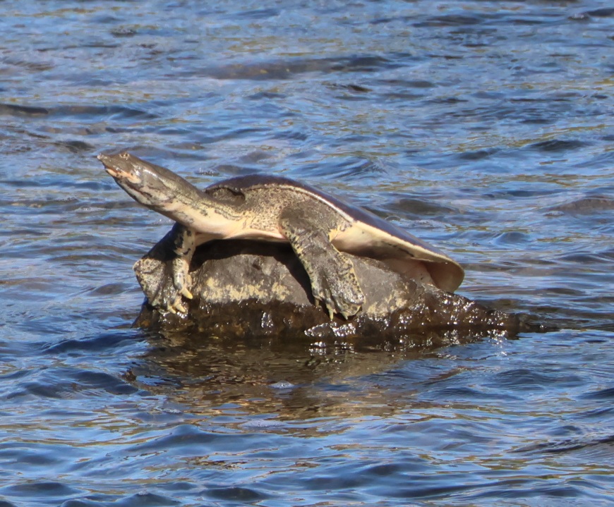
A little over a year ago, I got a new camera and lens that allow me to take photos of fairly far-away birds. With a teleconverter attached, it’s effectively around a 500mm telephoto lens. Sometimes the birds are so far away that I can’t really tell what kind of bird it is that I’m photographing. For instance, when I took the earlier photos of the crissal thrasher, I was 95% sure that it was a northern mockingbird until I got home and looked at the photos closer to full-size. Same thing happened with a loggerhead shrike this winter: I thought it, too, was a northern mockingbird until I got home. Well, this thing in the Las Vegas Wash, photographed on Feb. 13, 2026 from maybe 75 yards (68 m) away, looked to my eyes like some kind of bird so I took its picture. I was wrong. It is, as the heading indicates, not a bird. This is a Texas spiny softshell turtle (Apalone spinifera emoryi), a non-native species to the Las Vegas Wash. This is most likely a female, because a female Texas spiny softshell turtle has a carapace (something akin to a shell) measuring about two feet (61 cm) long. The species is naturally found in the Rio Grande and Pecos river drainages of Texas and New Mexico, but someone (likely) released this species into the Las Vegas Wash some time ago and now they’re pretty well established. This is yet another reason that I will never dip my toe in the Las Vegas Wash.
Verdin
Let us turn away from turtles and return once again back to birds. This was one of the last birds I photographed in our winter in Las Vegas. It was one of four or five verdins (Auriparus flaviceps – that one’s fun to say, too) at Springs Preserve on Feb. 28, 2026, that were flitting back and forth between a tall tree and this good-sized pipe organ cactus. I was finally able to get a couple of decent photos when this one settled for a bit on a cactus thorn. That’s a good-sized thorn: a verdin is only 4 1/2 inches (11 cm) in length. I got some decent pictures of verdins over the winter at Clark County Wetlands Park, but I’m happy with this photo (and I’m also well-aware that it is 95 percent luck). We saw several of these beautiful little birds entering and exiting their nests while at Springs Preserve: it’s an exciting time of year!
White-crowned sparrow
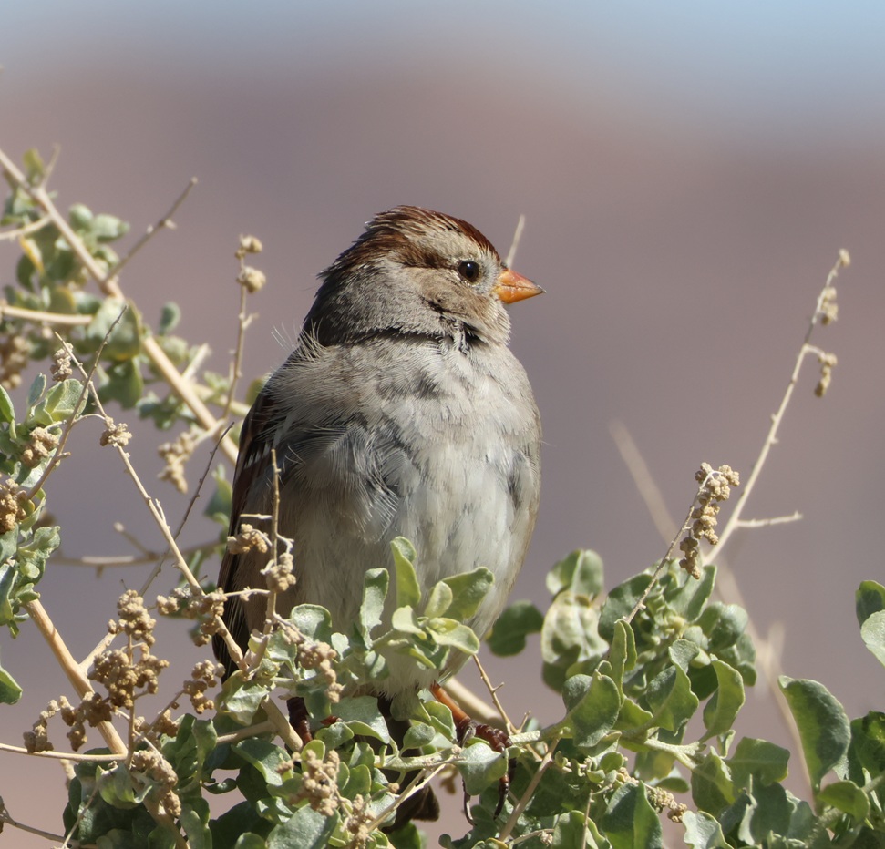
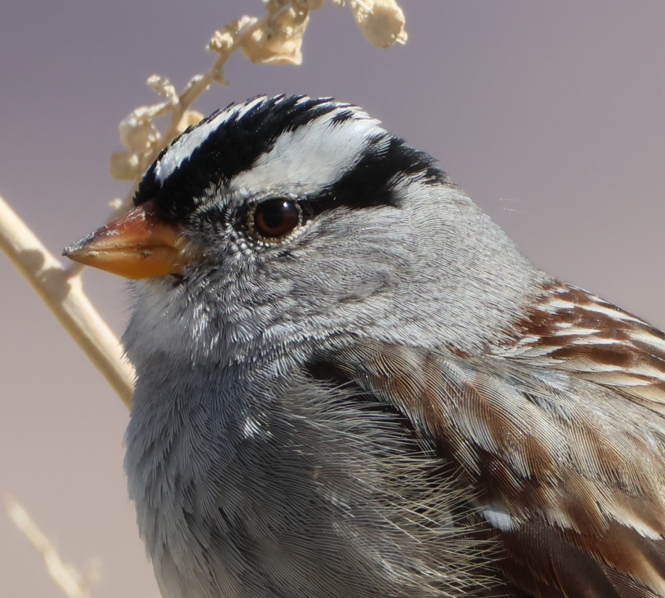
As I noted above, I have a camera that lets me get photos of far-away subjects. It also works pretty well when the birds are relatively close. At the trailhead of the Wetlands Loop Trail at Clark County Wetlands Park, the sidewalk goes by a lot of shrubs called four-wing saltbush. Those shrubs provide a favored perch for white-crowned sparrows (Zonotrichia leucophrys), who usually let Gunther and me walk on by, without taking off, when we’re on the trail. I was able to photograph a juvenile (top) and adult from a very close perspective. White-crowned sparrows are among the most gregarious wild birds I know, and the ones that hang out next to the Wetlands Loop Trailhead are perhaps the most sociable I’ve ever seen. Maybe it’s all the foot and bike traffic they see during the day, but it was great to be able to get these detailed photos for a close look at their feathers and coloration.
One of the things that really appeals to be about birdwatching is being able to see the similarities and differences between species: the coloration (some species have wildly different color patterns between males and females, for instance); the differences in size and shape of beaks/bills, wings, and tails; even noting that in some species, like ring-necked ducks, the drakes have bright yellow eyes and the hens have beautiful brown eyes. All of the birds in this posting were photographed within no more than 15 miles of each other: the riparian habitat at Clark County Wetlands Park brings a lot of birds to Las Vegas that wouldn’t normally stop there, and there’s great diversity even between the native desert birds like crissal thrashers and hummingbirds.
I keep a list, beginning on Jan. 1 of each year, to keep track of how many different bird species I see during that year. My goal is always 100 different species, and I’ve never met it (I got to 94 in 2023, 62 in 2024, and 96 in 2025). In the first two months of 2026, I’ve recorded 36 different species, all of which were observed in either Clark County Wetlands Park or the Springs Preserve in Las Vegas. With a 3,000-mile trip scheduled through the American Southwest, Midwest, and Upper Midwest, along with a 3,000-mile trip back to Las Vegas in the fall, I’m feeling pretty good about my chances of meeting my goal of 100 observed bird species this year. I hope my little Anna’s hummingbird pal is back on top of his tree next to the dog run when we return to Las Vegas in December.
Bird species observed in the Las Vegas, Nevada, area in January and February 2026
This is the third winter we are spending in Las Vegas, Nevada. The benefits of spending the winter in the Mojave Desert are many: the temperatures remain fairly warm compared to the rest of the United States (important for even the best-insulated recreational vehicles out there); the campground at which we stay has a number of amenities that we appreciate; and the Entertainment Capital of the World has a lot to offer, extending far beyond casinos, theatrical entertainment, and concerts.
One of those attractions we’ve really enjoyed visiting is the Springs Preserve, a beautiful 180-acre piece of land just west of downtown Las Vegas owned and operated by the Las Vegas Valley Water District. True to its name, the Springs Preserve is the original site of the city’s water source – it has since dried up, for the most part, but the property continues to offer a number of different attractions: botanic gardens, several museums (including the Nevada State Museum), a recreated “boomtown” that shows what early Las Vegas was like, hiking trails through the desert, and much more.
We’d been to the Springs Preserve many times in the previous two years, but never to its Butterfly Habitat because it closes for the season, due to cold weather (cold for the Mojave Desert, anyway) in late November. Nancy and I made visiting the Butterfly Habitat a priority for the early part of our 2025-2026 winter in Las Vegas, and we’re glad we did.
You’re familiar with the lifecycle of a butterfly, which includes four distinct metamorphic stages: adults (the ones that fly around) lay eggs on the underside of plant leaves or along stems; the larval stage hatches from those eggs as a caterpillar; the larvae encase themselves in a cocoon or chrysalis; and the adult emerges after a few days or weeks to fly around and the females lay eggs once again.
Butterflies have four wings: two forewings and two hindwings. Some butterflies live only for a few days as adults, and others, like monarchs, can live up to a year. The average lifespan of an adult butterfly is a mere two weeks, which makes seeing them extra-special.
Incidentally, Clark County in southern Nevada is home to Las Vegas and about 135 species of butterflies. They visit the Las Vegas area year-round, heading up to the higher elevations of the nearby mountains to wait out the sweltering summers and some species find warmer microclimates in the winter months. The butterflies at habitats like that at the Spring Preserve, none of which are native to Las Vegas and few of which are even found naturally in this country, come from several suppliers in the United States as eggs or caterpillars.
Here’s a look at the twelve (12!) different species of order Lepidoptera we encountered at the Springs Preserve Butterfly Habitat.
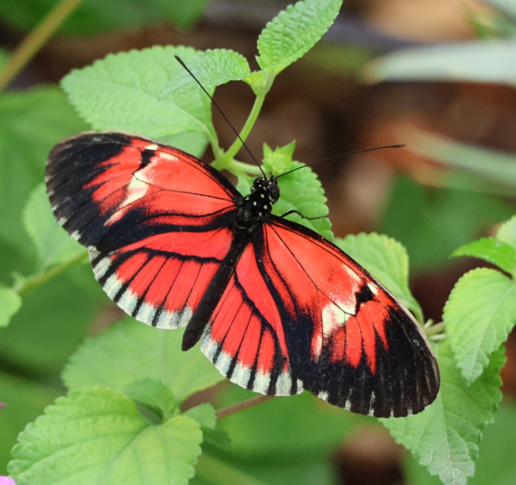
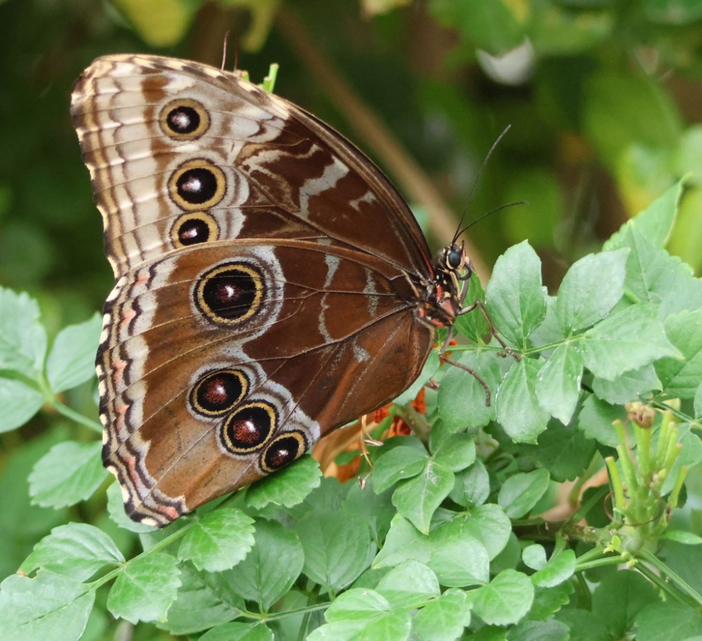
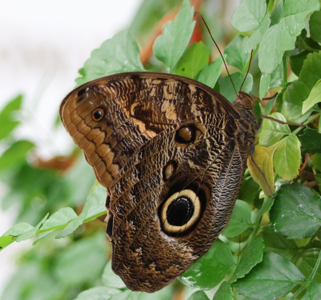
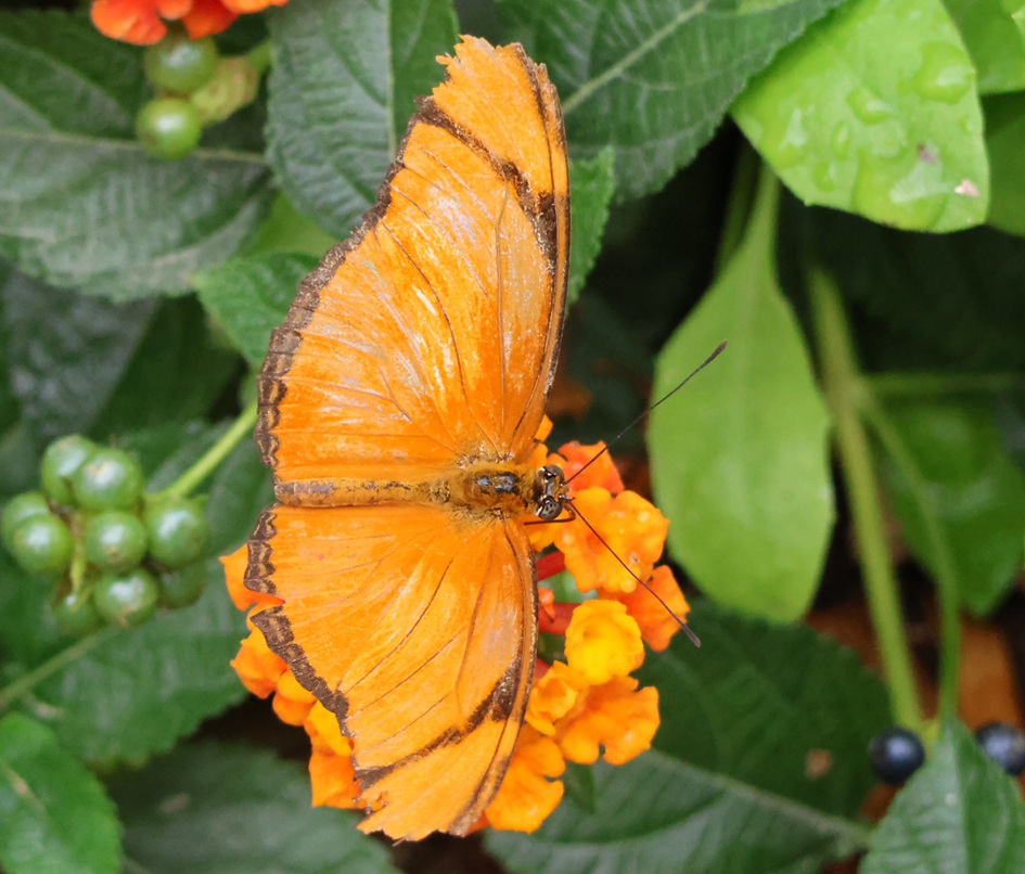
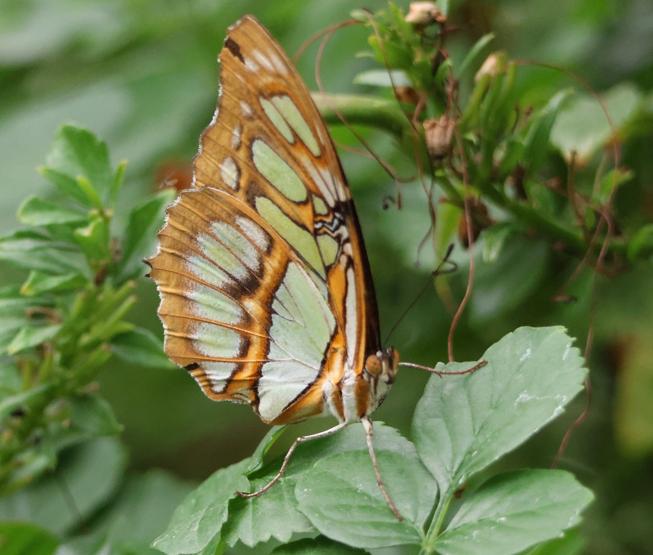
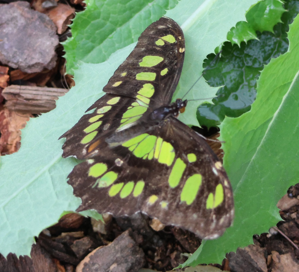
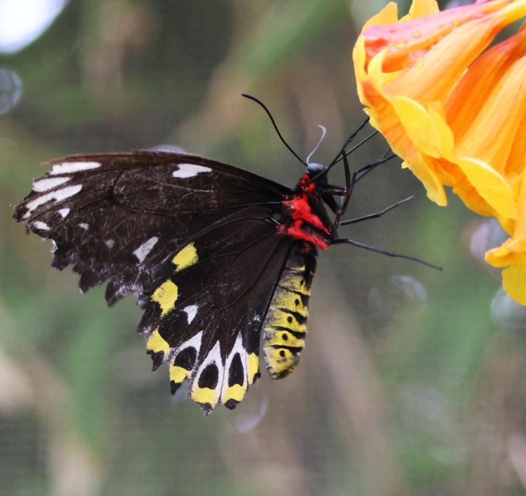
Before entering the habitat, which is fully enclosed to keep the butterflies and their food sources warm, staff and volunteers speak about the rules. If you’ve been to a butterfly habitat before, you’re familiar: don’t touch the butterflies (the scales on their wings are incredibly fragile), don’t step on the butterflies (they sometimes land on the sidewalks of the habitat), and make sure no butterflies leave the habitat on your clothing or body as hangers-on (no one wants to see non-native butterflies loose over the streets of Las Vegas). Although the habitat is a fairly good-sized structure, once we were inside the building Nancy and I probably didn’t move more than 10 feet from the entrance for a good 10 minutes. There was just too much to see! One of the first butterfly species we saw was the zebra longwing (Heliconius charitonius), also known as the yellow-barred heliconian. There were many of these black-and-yellow butterflies flitting about the entire habitat. The species has a wingspan of between 3 and 3 3/8 inches (75-85 mm). The color pattern is aposematic: the stripes warn predators to stay away from it. Zebra longwings are native to the gulf states, but sometimes can be found as far west as Kansas and as far north as South Carolina.Here is another species we saw frequently in the habitat: the postman butterfly (Heliconius melpomene). Like the previous species, the postman’s bright colors warn predators to look elsewhere for a meal. In the wild, they are found throughout Central and South America – particularly on the slopes of the Andes Mountains. This species has a wingspan of 1.375 to 1.5 inches (35-39 mm).This is an image of another postman, showing the underwings as it perches on this plant stem. Postman butterflies can see in the ultraviolet spectrum, which allows them to distinguish between different species of butterflies. The postman butterfly has been on the planet for a little over 2 million years (not this particular one; the species as a whole – after emerging from its cocoon, a postman butterfly lives for about six months in the wild).Cattleheart (Parides iphidamas) butterflies in the wild get their nutrients from a plant called pipevine. The adult butterflies ingest a toxin from pipevine, which keeps predators from eating them as well as the caterpillars. This species, too, is found in Central and South America. Nancy and I both appreciated the dark coloration, coupled with the bright magenta spots on the hindwing, of this species.Here is a butterfly probably familiar to all, the monarch (Danaus plexippus). Monarchs are one of the great migratory species of the animal kingdom. While many butterfly species make their way across relatively short distances to warmer climes as the seasons change, monarchs fly thousands of multi-generational miles each year. Their wings, spanning 3 1/2 to 4 inches (8.9-10.2 cm), carry them from southern Canada, throughout the western, central and eastern United States, and finally into Mexico, and then back again in the spring. (Unlike some other migratory animals, like birds, the trip takes roughly four generations each season – but it’s still an admirable feat.) By the by, this is a male monarch – you can tell because of the little black dots on the black stripes on the hindwings near the end of the thorax.Here’s one of the larger butterflies we saw in the habitat, the common blue morpho (Morpho helenor peleides). The wingspan of a common blue morpho is an uncommon 3.0 to 7.9 inches (7.5-20 cm). Those of you fortunate enough to be viewing this blog on color screens will notice there’s not much blue on this bug. Here’s the deal on blue morphos, which are from Central and South America: they don’t much care for cold temperatures. Daytime highs in Las Vegas had plummeted into the mid-60s during our mid-November visit, and it had briefly rained the night before. All butterflies are cold-blooded and rely on their environments to regulate their body temperature. In order to conserve heat, this blue morpho kept its wings closed the entire time we were in the habitat. If it had been a little warmer, we probably would have seen the brilliant blue of the tops of its wings – judging from the pictures I’ve seen online (I have a color monitor), they’re just gorgeous. The underside of the wings are pretty attractive too, of course. Some of the butterflies we saw, like this paper kite (Idea leuconoe), appeared to be yearning to be outside the habitat. However, it was much warmer, and the butterflies had much easier access to food sources, inside the building. Paper kites are natives of southeast Asia but can also be found in northern Australia and southern Taiwan. They have wingspans of 4 3/4 to 5 1/2 inches (12-14 cm). I really liked the subtle yellow-to-white coloration on this butterfly; while it doesn’t necessarily scream “DON”T EAT ME! SERIOUSLY!” like patterns we’d seen on other species, I’d probably refrain from doing so anyway.Speaking of escaping the bonds of the butterfly habitat, one of the volunteers there said that they really have to keep on eye on this species, the great southern white (Ascia monuste), to make sure it doesn’t follow visitors out the door.This picture happens to show the butterfly’s proboscis, which uncurls so that the butterfly can ingest nectar and other nutrients. In visiting a number of different flowering plants, many butterflies are important pollinators. Great southern whites are found on the Atlantic and Gulf coasts of the United States and on south to Argentina, with individuals occasionally straying to Kansas and Colorado. Great southern whites have wingspans of 2 1/2 to 3 1/2 inches (63-86 mm), a little bigger than half the size of the previously pictured paper kite.Hey, who let this giant owl into the forested butterfly habitat? I’m just kidding with you right now. This species is, in fact, a forest giant owl (Caligo eurilochus), another huge butterfly that has absolutely gorgeous multicolored top wings but this cranky guy never opened his wings during our visit. When they do open, the wingspan of a forest giant owl measures up to 6 3/4 inches (17 cm). In the wild, this species is found in Mexico, Centrai America, and down to the Amazon River basin. There are about 20 species within the owl butterfly genus, which gets its name from the eyespots on its underwing. The scientists are still undecided about the purpose of the eyespot; it might be an adaptation to mimic a large bird’s face, or it might serve as a target so that predators attack the wing rather than the body of the butterfly.This pretty species, Julia butterfly (Dryas iulia), is native to Brazil and up to Texas and Florida, and can sometimes be found as far north as Nebraska. Their wingspans measure 3 1/4 to 3 1/2 inches (82-92 mm). I liked how the color of its wings matched that of the blossoms of this lantana plant. There are 14 recognized subspecies of Julia.This is a terribly out-of-focus photo, but it’s the only one I have of this species. Its wings are not green, but rather display the color of the leaves on which it’s perched. The butterfly’s wings are transparent, giving it the name glasswing (Greta morgane oto). It is found in Central America and northern parts of South America, with occasional forays up into southern Texas and down to northern Chile. Its wingspan measures 1 to 1 1/4 inches (2.8-3 cm). This little butterfly looks pretty delicate, but it can carry up to 40 times its own weight – it, too, is a noted migrator. Malachite is a mineral that is bright-green in color, and it gives its name to this species of butterfly. The malachite (Siproeta stelenes) butterfly is fairly large, with a wingspan measuring between 3 1/4 and 4 inches (8.5-10 cm). It is found throughout Central and South America, and occasionally makes its way into Cuba as well as the southern parts of Texas and Florida. If you’re still reading this with a color screen, you’ll notice that the green on the wings isn’t particularly bright, so why is this butterfly called a malachite?This is why. Remarkably, this is the same butterfly species, malachite, as the one pictured above (although not the same butterfly; this one has a black body). It illustrates the huge difference between coloration patterns on the top and bottom of the wings of some butterflies.I’ll close with a couple of photos of another butterfly that illustrates the sharp difference between coloration of the top and bottom of its wings. We saw a lot of these butterflies, the common green birdwing (Ornithoptera priamus); in the wild they’re found in the western Pacific islands and northeast Australia.Again, this is the same species, common green birdwing, as in the preceding photo. Those are some bright colors, and even the bug’s thorax and abdomen are getting fancy. There are more than 20 subspecies of green birdwings.
Nancy and I spend a lot of time observing wildlife, mostly birds. It’s a relaxing pastime for us, and it’s a great way to get out to appreciate nature. The visit to the Springs Preserve Butterfly Habitat was incredibly rewarding, and I noticed, among the vibrant colors and the wide variety of sizes and body shapes, a big difference compared to other wildlife encounters. There were no birds chirping or calling to another, there were no hooves or paws passing through the grass, there were no sounds of grass being pulled from the ground or leaves being stripped from trees as food. Butterflies are totally silent, and they’re absolutely beautiful.
As I noted, the Springs Preserve Butterfly Habitat closes near the end of November and then closes for the winter months. If you find yourself in the Entertainment Capital of the World and want to do something pretty quiet, the habitat is a great way to get away from the noise and bright lights of Las Vegas. Check the habitat’s website (www.springspreserve.org/explore/butterfly-habitat.html) for current operating hours.
Works Consulted
Interpretive signage at the Springs Preserve Butterfly Habitat
“Field Guide to Insects & Spiders,” National Audubon Society, Borzoi Books, 2006
Wikipedia articles on various butterfly species; if you use Wikipedia, please consider supporting it financially
Finding a parking spot for our Ford F-350 pickup, the 22-feet-long and six-wheeled towing unit of The Goddard, is sometimes a challenge. We usually just park on the outskirts of businesses’ parking lots because, unless the parking spots are oversized, we sometimes take up more than one space. When visiting Yellowstone National Park in September, we realized that we needed to get early starts in order to find spaces in the park’s parking lots: we arrived after Labor Day and park rangers assured us that visitation had noticeably dropped, but parking spaces were still at a premium beginning in the late morning hours, So it was when we visited Norris Geyser Basin, located in Yellowstone’s northwest quadrant: we arrived at about 8:30 AM on September 12 and happily found a parking space. It was already getting pretty chilly in mid-September: high temperatures in the basin that week were in the mid-60s Fahrenheit (about 18 degrees Celsius) and pre-dawn low temperatures were in the low to mid-30s Fahrenheit (about 0 degrees Celsius).
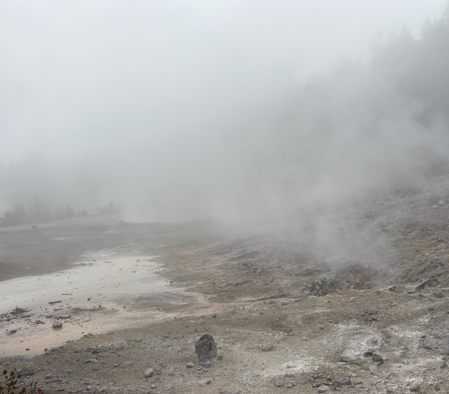
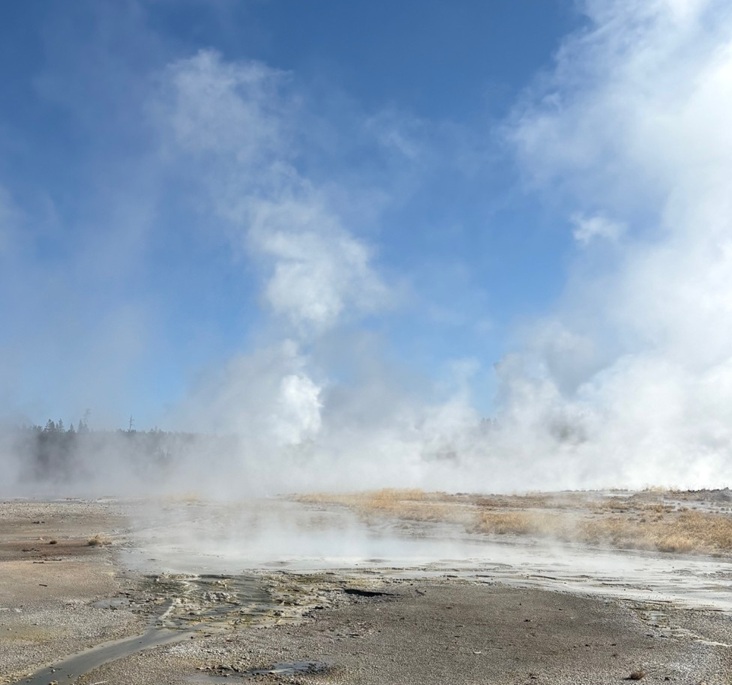
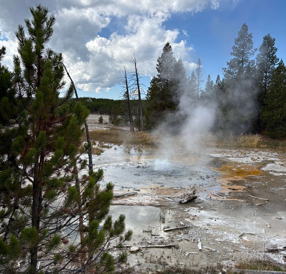
Those cold air temperatures combined with the hot steam rising from abundant geothermal features to create an otherworldly effect; it was extremely foggy, which made it difficult to discern any of the geysers, hot springs, and other features. The day soon warmed up, however, and the features revealed themselves. There are two different loop walks around Norris Geyser Basin: the longer and more forested Back Basin, which we visited later the same day (see that posting for an explanation of the different types of hydrothermal features, which I won’t repeat here), and Porcelain Basin. Here’s a look at some of what we saw in Porcelain Basin, once the air cleared a bit.
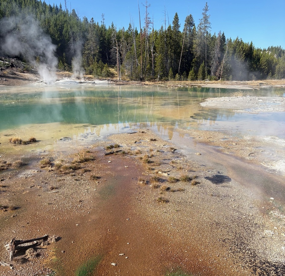
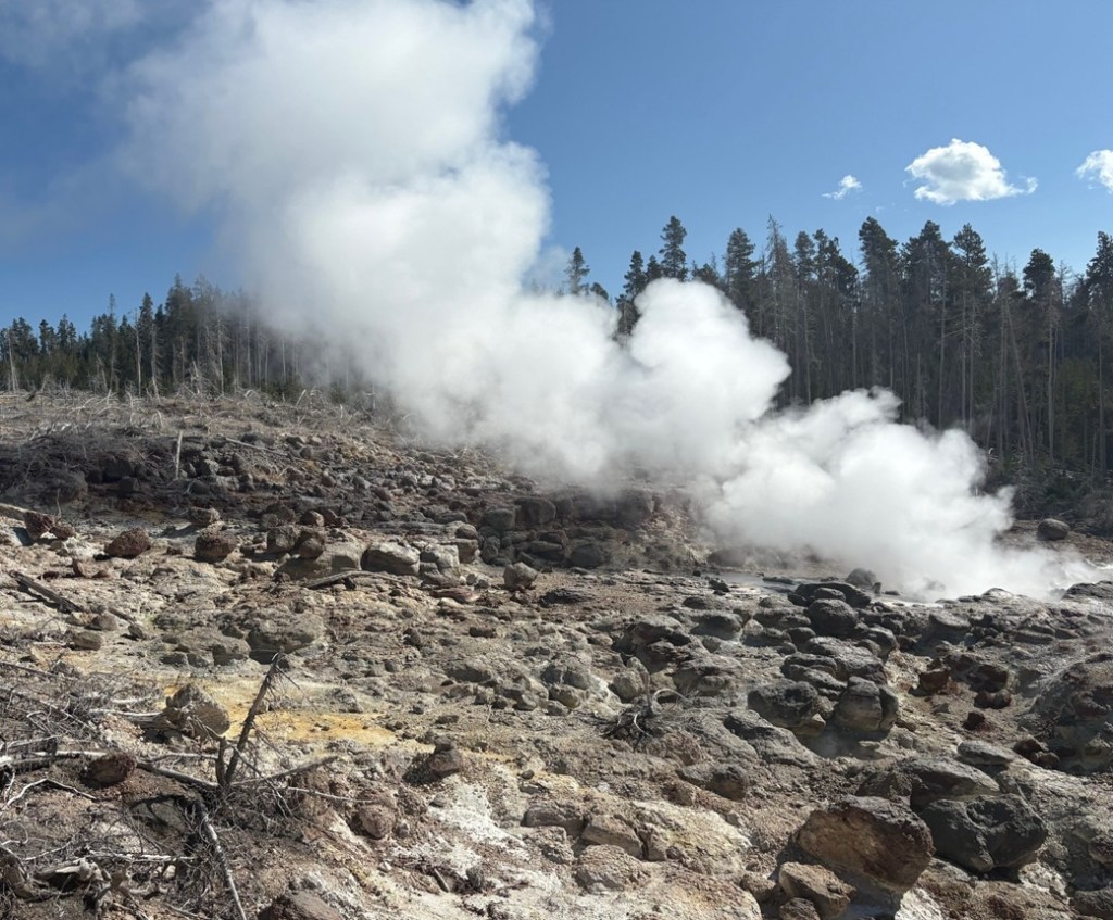
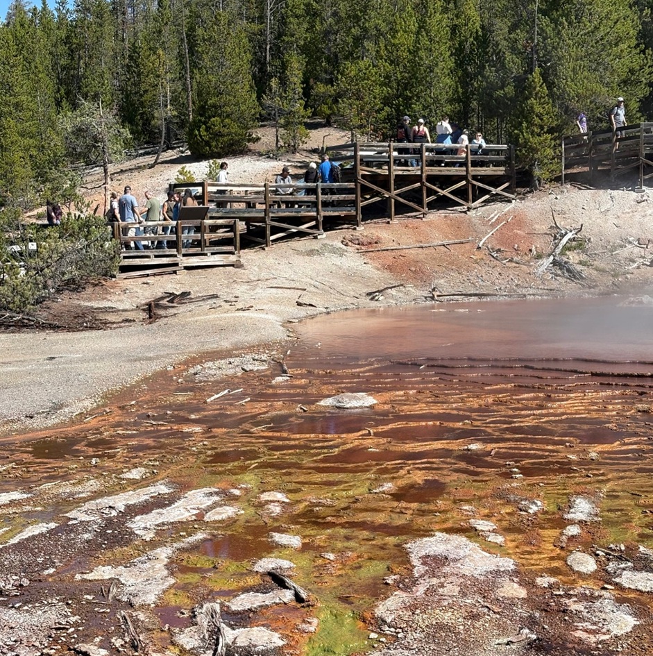
Those are some impressively large logs. This is the north-facing side of the Norris Geyser Basin Museum, designed by architect Herbert Maier (1893-1969) and built between 1929 and 1930. The museum, at 7,560 feet (2,304 meters) in elevation, was our first stop at Norris while we waited for the fog to dissipate. Maier also designed three other buildings in Yellowstone National Park: still-standing museums at Madison and Fishing Bridge, and the Old Faithful Museum of Geothermal Activity. Together, the four structures, built in an architectural style known as “National Park Service Rustic” that attempted to connect manmade buildings with the natural environments in which they were constructed, interpreted the geologic features on the Grand Loop road. Unfortunately, the museum at Old Faithful was demolished in 1971 to accommodate a new visitor center; that structure was itself demolished to make way for the current visitor center that opened in 2010. Maier also designed still-standing buildings in Yosemite National Park in California and Grand Canyon National Park in Arizona, as well as a number of structures in state parks in Texas.This picture, I think, really captures the extraordinary beauty and kaleidoscopic color of Yellowstone National Park. (Not really: it captures the foggy conditions at Porcelain Basin for the first hour or so after our arrival.) This hillside is venting sulfuric acid, gas, and steam, and the colder temperatures on the morning of our visit made the venting look quite pronounced. Norris Geyser Basin is the hottest area in Yellowstone National Park, in which one only needs to dig four miles downward to find magma – rock that’s so hot that it has become liquified (one wouldn’t necessarily want to do that, though). The average surface temperature in the basin is 280.4 degrees F (138 degrees C), and a probe sent 1,086 feet (331 meters) under the ground’s surface registered a temperature of 464 degrees F (240 degrees C). A vent from which gases and steam escape is called a fumarole (from the French fumerolle, which is a domed vented structure built over a stove to allow steam and smoke to escape); a fumarole that vents sulfuric gases (like these in the photo) is called a solfatara, while a fumarole that vents carbon dioxide gases is called a mofetta. A muffuletta is a delicious Italian sandwich popularized in New Orleans, but that’s not important right now.These pools, collectively called Porcelain Springs, give their name to the basin. They’re supposedly very pretty when the sun is shining on them, but I guess we’ll never find out for sure. The white mineral surrounding the bodies of water is called siliceous sinter, also known as geyserite. The silica is brought to the ground surface by the hot water in the pools, and accumulates very slowly – about an inch per century. Relatively new sinter is white; as it ages it turns to a darker gray color. The hydrothermal features in the greater Norris Basin, including both Back Bay and Porcelain basins, contain the highest level of silica in Yellowstone National Park – it’s what contributes the white milkiness (some might say porcelain-like) attribute to these bodies of water. Other minerals, like iron, arsenic, and sulfur, are all abundant as well. The latter contributes a distinct aroma to walks around these basins.This photo, too, is indicative of what we saw while waiting for the fog to go away. As you can see, Porcelain Basin is not a terribly inviting place if the sun isn’t shining. These trees, interestingly, found the conditions in the soil conducive to germinate, grow, and mature into tall pines; the soil conditions later changed because of geothermal activity in Porcelain Basin and made the ground inhospitable to many lifeforms. Most of Norris Geyser Basin is walkable only on boardwalks like this one: the ground is too fragile (and, remember, it’s nearly 300 degrees) for visitors to walk on directly.I took this photo from about the same position as the previous one (the boardwalk is just to the right side of the image), but looking slightly to the left and about half an hour later. You can see the sun was starting to emerge but steam is still rising from Nuphar Lake, which is itself not a geothermally heated body of water – it’s just plain old steam evaporating as the air temperature rises. Nuphar Lake (nuphar is a genus of flowering aquatic plants) has an interesting recent story, however. In 2021 and 2022, the lake’s water level rose by several feet (about one meter). Apparently, a geothermal feature near the lake began sending silica-laden water into the lake rather than into Porcelain Basin, which turned the lake’s water cloudy-white. The water level rose so dramatically that Nuphar Lake threatened to overflow its banks and into Porcelain Basin (which would have been pretty bad, because there are a lot of really pretty features there). By the end of the summer of 2024, though, the water level receded to its previous level and the color of the water returned to its normal clear green. Geologists found that an earthquake that occurred in April 2024 near the lake created a 10-foot-wide (about 3 meters) crater and caused water to stop flowing from the hydrothermal features. The dead trees in the previous photo, and those in the foreground of this photo, were killed by the silica-rich hydrothermal water that had been flowing into Nuphar Lake. That’s one big takeaway from our visit to Yellowstone National Park: nothing’s ever the same, and you can’t count on anything being there on a subsequent visit.Well, well, well … look what decided to finally show up: the sun. This is the same Porcelain Springs body of water that’s in the upper-left corner of the image three photos up. A sunny day does make all the difference – they are very pretty after all. Like porcelain, almost.The steam in Porcelain Basin, made more prominent because of the morning’s cold temperatures, was finally starting to dissipate so that we could see what else the basin had to offer. The sun was already pretty high up in the sky by that point, but it made for an interesting look. No retinas were damaged in the taking of this photo; the steam was a lot denser than it looks in the image.This is Hurricane Vent, which once was a fumarole but has increased in size to include more water action as well as a small waterfall on its side. It was pretty noisy, and interesting to watch.I took this photo just a few steps down the boardwalk from Hurricane Vent. This is looking to the southwest and at Ledge Geyser, which, while it rarely actually erupts, was certainly impressively active and loudly spouting steam from several of its vents during our time in Porcelain Basin. When Ledge does erupt, the geyser sends water more than 80 feet (24 meters) into the air. The Norris Geyser Basin Museum is on the other side of Ledge Geyser and up a hillside in this photo.Here we’re looking northeast from the Porcelain Basin boardwalk and at Constant Geyser. When it erupts, Constant’s spouts of water can reach 20-30 feet (6-9 m) into the air, but last only about 10 seconds. The geyser can go 20 minutes or several hours between eruptions.A few steps down the boardwalk, Whirligig Geyser (on the right) has eruptions that can be heard throughout Porcelain Basin. That green-hued stream on the left is the East Fork of Tantalus Creek.Here’s a closer look at the East Fork of Tantalus Creek. In Greek mythology, Tantalus was one of the (many, many, many) sons of Zeus who, for whichever transgression(s) you might choose to believe, was sentenced to stand in a pool of water under a fruit tree. The fruit was forever just outside his grasp, and, when he bent to get a drink, the water below him always receded. Anyhow, the beautiful green color of this creek comes from the thermophiles, or heat-loving microorganisms, that live in the water, in particular Cyanidioschyzon (I did not, despite how much I would have liked to, make that word up). It’s a genus of algae that thrives in water that’s 100-126 degrees F (38-52 degrees C). The steam from Whirligig Geyser is obscuring them in this photo, but there’s also a population of red-colored thermophiles that is thriving in hotter waters (122-160 degrees F, 50-60 degrees C) closer to Whirligig’s opening. The red coloration comes from the iron oxide that is in the geyser’s outflow. You’ll recall from high-school biology and chemistry classes that the pH scale is used to measure the concentration of hydrogen ions in a chemical. The scale goes from 1 (most acidic) to 14 (most alkaline), with 7 in the middle at neutral. Some of the water features in Norris Geyser Basin have a pH value below 2; they’re nearly as acidic as vinegar. It takes a tough little organism to live in that hot, acidic environment.This body of water, situated near the end of the Porcelain Basin loop, is Crackling Lake, named for the popping sounds made by geysers seen on its shoreline on the left.Here’s a last look at Ledge Geyser. This photo was taken from the other side of the plume of steam from where I took the previous photo of Ledge (note the other folks on the boardwalk looking at Constant, Whirligig, and other geysers to the left-center of the photo). Even though it never erupted, Ledge Geyser was a most impressive hydrothermal feature that made it hard to forget that molten rock was just four miles below our feet.
After a brief respite in the parking lot (and our prime parking spot) for lunch, Nancy and I enjoyed the features of Back Basin. We saw a lot of hydrothermal features that day – fortunately the fog over Porcelain Basin lifted about an hour after our arrival so that we could see them – and my guess is that the next time we visit, we’ll see a difference in a national park in which nothing is ever truly the same.
Works Consulted
Lynne, Bridget Y. “The Geothermal Guide to Yellowstone National Park.” 2017.
National Park Service. “Norris Geyser Basin Trail Guide.” March 2024.
National Park Service interpretive signage at Norris Geyser Basin Museum and at features throughout Porcelain Basin.
Wikipedia, accessed October 2025. If you use Wikipedia, please support it.
Norris Geyser Basin, located in the northwest quadrant of Yellowstone National Park, is one of the most active hydrothermal regions in the park and contains rare types of geysers within a geologically active earthquake area. The basin is located near the intersection of three major ground faults, helping to create the conditions for Norris’s significant geothermal activity. It’s outside the huge Yellowstone Caldera, the basin that remains after a titanic volcanic eruption 631,000 years ago, but within another 2.1-million-year-old caldera.
Nancy and I spent nearly all of Friday, Sept. 12, 2025, at Norris Geyser Basin. Named after Philetus W. Norris, the second superintendent of Yellowstone National Park, the geyser basin has two decidedly different trails: a short 3/4-mile (1.2 km) loop through the Porcelain Basin, and a longer 1.5-mile (2.4 km) loop with stops at geothermal features in the Back Basin. Both geyser basins are at an elevation of about 7,600 feet (2,316 m). Both trails involve the use of many boardwalks to keep visitors from walking too close to the heated features, and the ground is very thin in many spots and bad things would happen if someone broke through (and bad things do happen when someone decides to ignore the rules). I’ll write a posting detailing the Porcelain Basin later; for now, here are some of the sights to see and smell at Norris’s Back Basin, which includes the world’s tallest active geyser.
Before we get started though, let’s review hydrothermal features. Yellowstone National Park’s hydrothermal features are created by magma, which is partially molten rock, remarkably close to the park’s surface. Water, either from snowmelt or rain, percolates downward through faults and fractures in the earth’s surface and then, after making contact with the hot rock formation, rises back toward the surface and collects in open channels that serve as the hydrothermal features’ water supplies.
Geysers, perhaps the most familiar type of hydrothermal feature, form if the channel has a constriction of some type that pressurizes the water. Temperatures in the superheated and pressurized water below the constriction create steadily amounts of steam, which is eventually pushed through the constriction and an instantaneous drop in water pressure below the steam creates an eruption. These events can be fairly predictable, as in the case of Yellowstone’s Old Faithful, or irregular, with intervals between eruptions lasting unpredictable numbers of days, weeks, or even longer.
If a channel doesn’t have a pressurizing constriction, a hot spring is formed as superheated water comes to the earth’s surface, cools somewhat, and is replaced by hotter water beneath it.
The hottest hydrothermal features in Yellowstone National Park, fumaroles, are steam vents in which channel systems have little access to water, and whatever does reach the surface is immediately converted to steam with a temperature greater than that of water’s boiling point (212 degrees F, or 100 degrees C, at sea level).
Finally, mudpots are created when rock around a hydrothermal feature is converted, by acid, into clay. When it mixes with water, the clay forms mud of different colors and viscosities. Gases in the feature bubble up through the mud to make interesting sights, sounds, and smells.
All hydrothermal features are susceptible to changing environmental conditions. If access to water is changed, or the fissures around a feature are altered because of seismic activity, the feature’s activity could change dramatically or even cease altogether. Many geysers, for instance, that were active in years past are now quiet.
The first stop on the Back Basin Loop is this very pretty 27-foot-deep pool, Emerald Spring. The color of a particular hot spring can help determine what minerals that spring contains. Water in a relatively mineral-free clear blue spring, for instance, absorbs all of the colors of sunlight except for blue. Emerald Spring contains significant deposits of the mineral sulfur, the yellow color of which combines with the reflected blue sunlight to create this beautiful shade of green. The temperature of the water in this spring is close to the boiling point, ensuring that only the most heat-tolerant microorganisms, or thermophiles, can survive in this environment. There’s plenty of sulfur in this spring, which is used by some thermophiles as a source of energy. The byproducts from the sulfur’s usage in turn are used by other thermophiles, resulting in a kind of recycling process that creates something like thermophile interdependence.Next up is the world’s tallest active hydrothermal feature, Steamboat Geyser. Although there was a lot of steam evident, Steamboat Geyser on the day of our visit was relatively quiet with just a few intermittent spurts of water measuring a few feet high. When it goes, though, Steamboat really goes: it is capable of shooting steam and water up to 300 feet (91 m) into the air. That’s the distance of a football field. Prior to 1904, Steamboat was not the tallest geyser in the world. That honor belonged to a geothermal feature in New Zealand, Waimangu Geyser, which shot water a mind-blowing 1,600 feet (488 m) into the air. A landslide changed the water table around Waimangu, however, and it hasn’t erupted since.
Here’s the thing about Steamboat that’s really wacky: its eruptions are extraordinarily erratic. In the nearly 30 years between 1990 and 2017, Steamboat erupted 12 times (including one interval between eruptions that lasted almost 9 years). Between March 15, 2018, and May 7, 2023, a little over five years, the geyser erupted 165 times. We visited in mid-September 2025, and Steamboat’s last major eruption had occurred on April 14 – five months earlier. Before then, it erupted on Feb. 2, 2025, a little over two months earlier. In all of 2024, Steamboat erupted six times. Nature is chaotic sometimes, and it’s beautiful. Note the huge desolated treeless area in the photo above. The geyser’s eruptions, helped by prevailing southerly winds, caused that destruction.
Cistern Spring is located downhill from Steamboat Geyser – I didn’t measure the elevation change, but it’s at least 50 feet lower, and the boardwalk trail has a couple of switchbacks. However, Cistern Spring is connected underground to Steamboat because it empties completely whenever the larger geyser erupts. The brown, green, and orange colors in Cistern Spring are created by different species of thermophiles. The dead trees around the spring were killed by the silica in Cistern Spring’s water: conditions around the spring were once healthy enough for the trees to germinate, grow, and mature, but then the conditions changed. We saw that a lot all over Yellowstone National Park: big areas of trees that had been killed by changing hydrothermal features.This feature has one of the best names in the Back Basin. It’s Black PitSpring, and it started off about half a century ago as a group of steam vents. Water now continuously bubbles with very small eruptions at its surface.Here’s a closeup, using a telephoto lens, of the little eruptions from Black Pit Spring. It’s a pretty mesmerizing hydrothermal feature, with a great variety of colors (not so much black, though).This is Echinus (pr. e-KI-nus) Geyser, perhaps my favorite feature in the basin. It is named for its mineral deposits, which apparently look the spins of sea urchins (neither Nancy nor I are overly familiar with echinoderms like sea urchins, but we didn’t see anything that resembled sea urchin spines). The red color is due to high concentrations of iron oxide (rust) in the feature. Echinus’s eruptions, which can reach 60 feet in the air, are unpredictable and are now months and even years apart. From 1878 to 1948, the geyser rarely erupted but then moved to periods of relative high activity alternating with dormancy. Prior to 1998, it was on an eruption schedule of about every half-hour to 90 minutes. The scientists believe that something happened underground in 1998 to affect the geyser’s water source. For now, it’s a fairly large and very pretty pool of water (see the guy emerging from the trees on the boardwalk just right of center for scale).This photo was taken on the other side of the geyser from where the previous photo was taken, i.e. just to the right of the guy on the boardwalk in the photo above. Echinus Geyser is a beautifully complex hydrothermal feature, even if we can’t make out the sea-urchin-ish spines.Here’s one of the reasons why Echinus Geyser appeals to me so much: these are terrace formations on the geyser’s southwest side where water leaves the geyser. I took this photo at about the same spot as the photo above, but used my telephoto lens again. These terrace mats are formed by unthinkably large numbers of a microorganism called Archaea (pr. aar-KEE-ah), which is a an immense domain of life that precedes kingdoms (you remember, from high-school biology, the memory aid “Kings Play Chess On Fine Green Sand,” or Kingdom, Phylum, Class, Order, Family, Genus, Species; domain is a step above kingdom). Water coming from the geyser is 176.5 degrees F (80.3 degrees C), and has a pH of 3.3 to 3.6 – it’s nearly as acidic as vinegar. At this point in the terracing, the temperature drops to between 140 and 160 degrees F (60 to 71 degrees C). Archaea absolutely love this hot and acidic water, and survive on the energy produced by iron oxidizing in the geyser’s water then bind together to build these ridges, pools, and ripples. Archaea are very common in nature: different types are found everywhere on the planet, including other features in Yellowstone National Park, and your gut, mouth, and skin are covered in them right now (not the same ones in this picture; remember that Archaea covers a lot of different species, let alone all of the other Kings Playing Chess). It’s extremely likely that when the scientists do find irrefutable evidence of extraterrestrial life, it will be in the form of Archaea or something close to it. This is a view a little further down the boardwalk from Echinus Geyser. That small river of water is flowing northwesterly from the geyser – it’s a pretty desolate landscape in the river bottom, but remember that the river has a pH nearly equal to that of vinegar. Notice also the steam rising from the ground where the river meets the trees in upper left; as the scientists say, this is a geothermally active area, and that is evidence of yet another geothermal feature.This is Porkchop Geyser, so named because of its shape when viewed from above and which only intermittently erupted until 1985 when it started spouting on a continuous basis. Those eruptions wasn’t enough to keep the geyser’s constriction from building up tremendous pressure and four years later, on Sept. 5, 1989, this feature exploded with a violence sufficient to throw large rocks more than 200 feet (61m). Fortunately, the tourists present for this surprise event weren’t injured. Porkchop’s vent hole at times has been the diameter of a garden hose; after the explosion, it’s about 7 feet in diameter. After that event, Porkchop became a gently bubbling hot spring with only occasional – and unpredictable – geyser eruptions.Even if it didn’t erupt while we were there, Veteran Geyser was a lot of fun to listen to. The area in shadow in the lower right corner of the picture is a vent through which Veteran exhaled with what sounded like someone in severe respiratory distress. A couple with whom I’d briefly spoken at Steamboat was here admiring Veteran as well, and, realizing that we were nearing the end of the Back Basin loop, the woman asked what our favorite hydrothermal feature was. I quickly answered with Echinus Geyser, and asked what her favorite was. She said it was Black Pit Spring, but mostly because of the name. I couldn’t disagree with her. In a basin filled with features named Green Dragon Spring, Puff ‘n Stuff Geyser, and Black Hermit Caldron, Black Pit Spring does still manage to stand out.At the time when Yellowstone’s visitors toured via stagecoaches, Minute Geyser erupted every 60 seconds to heights of 40 to 50 feet (12-15 meters). Inexplicably, many of those tourists tossed rocks into one of the geyser’s vents and eventually plugged it. While it continuously spouts water about 3 feet (0.9 meter) now, it’s unknown whether the feature will ever fully erupt again. Signs warning tourists to not throw rocks, coins, or other objects into park’s hydrothermal features were all over Yellowstone. I just can’t wrap my head around why someone would want to do that in the first place.The Back Basin loop trail ends with a short hike up a hillside, resulting in this magnificent view of Norris’s other geyser area, the Porcelain Basin. I’ve got pictures of the features within Porcelain Basin as well, and will post those in the near future.
There are about 25 named features within Back Basin, so this was a look at less than half of what’s there. Walking around any of Yellowstone National Park’s hydrothermal areas gets you really close to all kinds of aspects of our natural world, and it’s easy to think that it’s always looked the way it appears today. But conditions underground, like earthquakes, heat changes, mineral buildup, and more, ensure that these features are anything but timeless: a geyser can become a hot spring (and vice versa), for instance, because of subtle and usually unseen geologic changes.
It was a fun day at Norris’s Back Basin, and one that Nancy and I will appreciate for a long time – especially because the next time we go, it may be significantly different.
Works Consulted
Lynne, Bridget Y. “The Geothermal Guide to Yellowstone National Park.” 2017.
National Park Service. “Norris Geyser Basin Trail Guide.” March 2024.
National Park Service interpretive signage at features throughout Back Basin.
Wikipedia, articles on Archaea, Echinus Geyser, and Steamboat Geyser. Accessed September 2025. If you use Wikipedia, please support it.
Homolovi State Park, near Winslow, Arizona April 16, 2025
We’re camping for two weeks in Homolovi State Park, just a couple miles east of the town of Winslow, Arizona (pop. 9,005; perhaps you’ve heard of it – one of its street corners is mentioned in the Eagles’ first major hit from 1972, “Take It Easy”). This is our third time staying here in three years – we really enjoy it. After spending five months wintering in Las Vegas, Nevada, and then a couple of campgrounds on Interstate 40 in Arizona, we’re appreciating the quiet environment and dark skies of this state park (not that we didn’t have a good time in Las Vegas; in fact, we’ve reservations to be back there beginning this November).
The main feature of this state park is a cluster of four major ancient Native American villages, several miles apart and all built and occupied around the years 1290-1400. The villages were then abandoned, but it’s generally understood that the people who lived here eventually became what is now the Hopi nation – one of the tribe’s reservations is about 60 miles north of present-day Homolovi State Park. The four villages are designated Homol’ovi I-IV; the name of the state park doesn’t include the apostrophe of the village names. “Homol’ovi,” in Hopi, translates to “place of the little hills,” and the Hopi also refer to the city of Winslow as “Homol’ovi.”
The Hopi call the people who lived here – most likely their ancestors – the Hisatsinom, which means “the people of long ago.” During the period in which the Hisatsinom lived in this region, they built and occupied four or five large villages – some comprising hundreds of rooms – using rocks gathered from the ground.
The Little Colorado River, a watercourse that drains the Painted Desert area of northeastern Arizona, flows through Homolovi State Park. I took this photo while Nancy and I were driving to Winslow; the perspective is looking north from a bridge on the former U.S. Route 66 (and now Arizona State Highway 87). The trucks and trailers just on this side of the horizon are on Interstate 40. The Little Colorado River’s headwaters are in the mid-eastern region of Arizona, very near the state’s border with New Mexico. It then flows almost 340 miles in a northwestern direction until it empties into the Colorado River in the Grand Canyon. The river flows from its headwaters all the way to the Grand Canyon only during periods of flash flooding or heavy snowmelt; much of the year it’s a braided and puddled wash. I took this photo the day after the area got some appreciable rain and snow, and the water level rose only marginally. The occasional flash flooding of the Little Colorado River, which swept away crops and structures, is probably why the Homol’ovi sites were abandoned in favor of the area further to the north and which the Hopi call home today.This is the site of a major native American village, known now as Homol’ovi I, that was last occupied about 600 years ago. At its peak, it contained about 1,100 different rooms constructed of rocks. Some of the rooms included three stories. Over the ensuing six centuries, a lot has happened to destroy these unoccupied villages. Dependable northern Arizona winds have covered the village with dirt and sand, but some structures, such as the one on the mound at the right, can still be discerned. Many of the rocks in the structures were taken by members of a nearby Mormon community in the late 1800s for use in their own buildings, and vandals have also destroyed the buildings and looted the pottery.
Take a look at the tall plants on the horizon at far left: directly to the right of them, you’ll see some white splotches (not the clouds, which are further to the right; the smaller white splotches of which I write are immediately to the right of the tall plants). Those are the San Francisco Peaks, still snow-covered in mid-April. The town of Flagstaff, Arizona, is at their feet. Those mountains are about 65 miles west of Homolovi State Park.I took a picture of this image, an artist’s depiction of what Homol’ovi I looked like at its peak, at an information kiosk near the site of the former village. That’s the Little Colorado River in top right. The original image gives credit to Douglas Gann of the Center for Desert Archaeology.
From about 1290 to 1360, it’s believed that Homol’ovi I grew from a village of 200 rooms to more than 700. Around the year 1360, the village now known as Homol’ovi II was established about 3 miles, or 5 kilometers, north of Homol’ovi I; that second village quickly became the biggest one in the cluster at 1,200 rooms. Homol’ovi I, however, benefited from the second village’s success, and grew to a maximum of 1,100 rooms.
This photograph was taken from the top of the hill shown in the previous photo, still looking to the northwest. The rocks in a line are the former wall of a room. The trees near the horizon are on the east bank of the Little Colorado River; it was that river’s occasional flash flooding that likely led to the abandonment of Homol’ovi I and the other villages 600 years ago.This is a small grouping of pottery shards and what appears to be a hand-shaped rock, taken from the ground at Homol’ovi I and placed on a larger rock. The pieces of pottery are roughly the size of an American half-dollar. There are thousands of shards like these at the site, and most of them are on larger rocks like this. Archeologists and conservationists prefer that people don’t do this; instead, simply leave the shards on the ground.This is the largest exposed wall still standing at Homol’ovi I, and it’s been almost entirely rebuilt by archeologists. Note the small collections of pottery shards on some of the rocks at left: don’t do that.THIS IS A TALES OF THE GODDARD LIZARD ALERT. This little guy (and he is a guy, and I’ll tell you why I know shortly) caught my eye as he scampered across the rocks and sand of Homol’ovi I. He is a side-blotched lizard, a genus (Uta) of which there are now seven species, and he and I were to have kind of a neat interaction. This photo of my new reptile pal shows why the genus is called side-blotched lizard – observe the dark mark (or, in scientific terminology, “blotch”) on its side just behind its front leg. The turquoise-blue dots on the back are also a defining characteristic of the genus. These lizards grow to a length of about six inches, including the tail. Their diet includes insects, spiders, and other arthropods such as the occasional scorpion. They are themselves predated upon by larger lizards and roadrunners.In an attempt to give the reptile some space, I continued walking down the path through Homol’ovi I – but the beast pursued me. Observe the very pretty light-blue dots on its back. I was about six feet from the lizard when I took this photo (using a 400mm telephoto lens).Here’s a cropped version of the previous photo. Behold those beautiful blue dots as well as some detail of its fearsome front claws. After I took the photo, the lizard continued to approach me: in fact, it got to about six inches from my left foot – and then it scampered away. Turns out, that’s a common behavioral trait of male side-blotched lizards. The scientists don’t know if the behavior is intended to scare away possible intruders from its mate, or to defend its territory. At any rate, I got the hint and moved along (even though my course on the path took me in the same general direction of the lizard, who at that point was many yards away). I later described my interaction with the side-blotched lizard to Nancy, who did not at all appreciate when I poked her under her armpit to show her where the blotch on the lizard’s side was. We also shared the same belief that she would have absolutely and completely freaked out if the lizard had gotten to within six inches of her left foot.More wildlife: I always like to include some bird photos in these postings, so here are a couple of images I took in our campground at Homolovi State Park. This is a black-throated sparrow (Amphispiza bilineata), a species found in the southwestern United States and much of Mexico. They are absolutely beautiful little birds. I’ve seen them only here at Homolovi State Park and at Tuzigoot National Monument, further west in Arizona.This is a loggerhead shrike (Lanius ludovicianus), on a tree just a few feet from the Goddard’s campsite. I remember reading about shrikes when I was young, but I didn’t see one in the wild until a couple of years ago at McDowell Mountain Regional Park east of Phoenix, Arizona. I also saw some over this past winter at Clark County Wetlands Park, very close to the campground where we spent the winter near Las Vegas. Loggerhead shrikes are found nearly all over the United States.
We’re planning to join a ranger-led tour of Homol’ovi II, which has been partially excavated and reconstructed, on Saturday, April 26. I’ll write and post photographs from that experience afterwards. We were on the same tour a couple of years ago, but, because of our travels and opportunities to see ancient Native American sites in the southwestern United States since then, we have a better perspective of what we’ll see.
Nancy, Gunther, Rusty, and I are wintering in Las Vegas, Nevada. We arrived here at the beginning of November 2024, with plans to depart in early spring of this year. There are worse places to spend the winter than Las Vegas: the campground at which we’re staying is surprisingly inexpensive with friendly folks and lots of activities, there are a lot of good restaurants and entertainment options relatively nearby, and, as we found out last winter (we spent five months here), there are a unexpectedly large number of hiking and birding opportunities very close to the city.
Gunther, Nancy, and I took advantage of one of those birding opportunities during the waning days of 2024 with a visit to Clark County Wetlands Park, located just a few minutes’ drive from our campground. The Las Vegas Wash, which I described in last year’s posting about the Owl Canyon Hiking Trail at Lake Mead National Recreation Area, creates the wetlands aspect of the park. Those of you who have spent much time in the desert city of Las Vegas might be surprised to see that a decent-sized creek runs through the east side of the metropolitan area. Las Vegas Wash is bigger at times, especially after heavy rains, than others. For those used to even small-sized creeks and rivers, it’s probably not a very impressive waterway. However, the Las Vegas Wash is absolutely critical for the health and sustainability of this area; the water in it is collected wastewater and runoff from the city’s hotels, golf courses, and other businesses, as well as residential wastewater and stormwater runoff, on a 12-mile journey (including through wastewater treatment plants) to the Lake Mead impoundment east of Las Vegas. Ninety percent of the water used in the Las Vegas metropolitan area is drawn from Lake Mead (the rest is from groundwater sources), so it’s imperative that as much water that’s used in the city gets returned to the reservoir as possible.
We’re currently close enough to the Golden State that I thought this might be a California quail as opposed to a Gambel’s quail (Callipepla gambelii), but it is indeed the latter. It, along with three or four more of its kind, was hunting on the ground just off the trail shortly after we started our walk. In addition to southern Nevada, this bird’s range includes regions of California, Arizona, New Mexico, and Utah, as well as little parts of western Colorado.
Whether it’s moving, still, salty, fresh, or freshly treated, water makes a huge difference in supporting wildlife populations; without the wash, many species of birds, lizards, and mammals simply wouldn’t be in this place. That fact was made clear to us on the day that we visited. Like most avid birders, I keep a record of each bird species we see during the year. Before we began the five-mile loop walk through the wetlands, we’d seen 50 different bird species in 2024; by the time the three of us climbed back into the Goddard’s six-wheeled towing unit to drive back to the campground, we’d seen 18 additional species, 12 of which were species not yet seen in 2024, and four of which we’d never seen before. In other words, nearly a quarter of the bird species we saw in 2024 were seen on the on the 363rd day of the year during this 2 1/2-hour hike just outside of Las Vegas.
Much of the 2,900-acre (4.5 square-mile) Wetlands Park is a nature preserve, into which Gunther (very understandably) can’t go. However, there’s a very fine concrete trail that skirts the outer perimeter of the preserve and also goes over a bridge that crosses the wash. It was from that bridge that we saw three of the four “lifers,” or bird species we hadn’t ever seen before.
This is a view from the Las Vegas Wash looking west toward Las Vegas Boulevard, or “The Strip.” It was an overcast and hazy day in the Las Vegas Valley, but you can just barely make out some of the structures on The Strip. Mandalay Bay Resort and Casino, the southernmost casino on The Strip and indicated by the green arrow, is about nine miles directly west of this position. The Stratosphere Hotel, Casino and Tower (I think it’s just going by The STRAT now) is indicated by the blue arrow and is located about six miles to the north of Mandalay Bay. (Incidentally, at 1,149 feet the Stratosphere’s observation tower is the tallest in the United States and is second in the Western Hemisphere only to Toronto’s CN Tower at 1,815 feet – but that’s a conversion from metric so who knows what’s really going on?) Anyway, the Spring Mountain Range is on the horizon, and in between Las Vegas Boulevard and the mountains is Red Rock Canyon National Conservation Area, which we visited last winter. Those are American coots swimming in the Las Vegas Wash on the right.We’ve seen lots of little white-crowned sparrows (Zonotrichia leucophrys) since becoming full-time RVers, especially in New Mexico and Arizona, but it’s always a pleasure to see (and hear) them again. Of all the little brown birds (LBBs), they are one of the easiest o identify. Small but mighty, these birds are exceptional migrators and have been tracked flying as many as 300 miles in one night.
Prior to becoming full-time RVers and when we still lived in Denver, Nancy and I visited Las Vegas at least once a year. Like most visitors, we arrived via airplane at Harry Reid International Airport (née McCarran International Airport), and took a cab to our hotel, either on The Strip, or, later and more regularly, in downtown Las Vegas. We’d spend a few fun-filled days, some more profitable than others, and then take a cab back to the airport and return home. A lot of people don’t realize that when they fly into Harry Reid International Airport, spend a few days recreating on The Strip then return to the airport to go back home, they’re not ever actually in Las Vegas – unless they go to the Stratosphere (I don’t care what it’s going by now; I’ll still call it the Stratosphere because I just got used to not calling it Bob Stupak’s Vegas World) or to downtown Las Vegas. Otherwise, each of the roughly 40 hotels and casinos, including places like The Bellagio, Caesar’s Palace, New York New York, The Luxor, The Wynn Las Vegas, and dozens more) along Las Vegas Boulevard, with the exception of the Stratosphere, is in unincorporated Clark County (as is the airport). Those hotels have a total of nearly 89,000 rooms (The Wynn Las Vegas alone has almost 4,800 rooms); compare to, say, downtown Denver which has about 11,000 hotel rooms and the biggest one, the Sheraton Denver Downtown, has 1,231 rooms). The point is, there are a lot of hotel rooms in Las Vegas (and tens of thousands more in unincorporated Clark County), and all of them have bathrooms with showers and flushing toilets, and all of that water needs to go somewhere.
Where it needs to go is into Lake Mead, and how it gets there is via the Las Vegas Wash. Wastewater treatment plant facilities clean up the water as it makes its way to the reservoir; during our visit to the wetlands on December 28, I was reminded of walking and biking on the Cherry Creek Regional Trail in Denver because of the unmistakable (and not entirely unpleasant – certainly more pleasant than it had been before) smell of wastewater under the process of being treated.
Anyhow, and as someone once wrote, back to the birds.
Here’s the first of the never-before-seen-by-us species: the Crissal thrasher (Toxostoma crissale). It’s very similar to a curve-billed thrasher, but the Crissal’s beak is even longer (and more curved, I think). This particular species prefers to stay on the ground, foraging for food, rather than fly about to fill its belly. In the United States, this bird is found only in the southern parts of California, Nevada, Arizona, New Mexico, and far western Texas. I usually avoid editing my pictures, other than cropping and re-sizing, but I decided to adjust the contrast on this one to bring out the bird better. The overcast conditions on the day we visited weren’t the best for photography, and many of the birds were far away (in the nature preserve, where, thanks to Gunther, we weren’t allowed. Thanks again, Gunther.)Happily, the sun happened to be out a bit more when we were on the bridge in Wetlands Park, and I got what I think are some pretty good photos. These ducks were far enough away that I didn’t know what species they were until we got back home and I could have a closer look at the images. This is another new-to-us species, the ring-necked duck (Aythya collaris). As is sometimes the case, the identification feature that’s in the name of this species isn’t really helpful in identifying it: the ring on the neck is very faint, and was probably more visible to early naturalists on captured birds. As a migrator, this species is found throughout North America in different parts of the year; during the fall, Minnesota lakes supporting beds of wild rice can sometimes have flocks of ring-necked ducks numbering in the hundreds of thousands. In this species, as with many other ducks, the male (right) and female (left) genders have remarkably different coloration most of the year (note the extreme difference even in their eye color). As was pointed out to me a few days ago by a full-time resident of this campground, the females of many bird species have to stay more camouflaged to protect the young hatchlings (in that case, we were talking about hummingbirds, but it’s true for many bird species). We’ve had the opportunity to see plenty of double-crested cormorants (Nannopterum auritum), especially at St. Vrain State Park in northern Colorado, but they were usually swimming. For some reason, there were a lot of cormorants on the wing this day at Wetlands Park. This one is showing off its wingspan, which can get to four feet long. Interestingly, despite being a water bird, cormorants do not have waterproof feathers – it’s why they’re often seen on shore with their wings spread. I recently listened to a very interesting audiobook about the Cretaceous-Paleogene Extinction Event, in which an asteroid struck the Earth 66 million years ago and brought the Age of Dinosaurs (mostly) to an end. The author consistently mentioned, though, that only non-avian dinosaurs, or those reptiles that couldn’t take to the air, were made extinct. I’ve mentioned it before, but double-crested cormorants (the white crests appear above the eyes of adult birds only during the breeding season) are one of the best reminders that, in an indirect way, avian dinosaurs still populate the earth.I’ve long been struck by how majestic and powerful most birds look when viewed from the side, or perhaps a three-quarter angle, and how they don’t look at all majestic and powerful when viewed face-on. This is a great blue heron (Ardea herodias), which spent a considerable amount of time among the reeds on the hunt for small fish.The angle makes all the difference: same exact bird. Great blue herons are a lot of fun to watch – they’re very patient while hunting and move almost imperceptibly, but then strike lightning-quick to pull fish from the water. If you look away for a moment, you may have missed all of the action. GBHs grow to a height of almost 4.5 feet and can weigh 5.5 pounds, with wingspans measuring more than 6.5 feet.I originally thought this was a snowy egret (and thus a lifer), but when editing the photo for this posting I realized that its beak is all yellow and its legs are all black (and it’s overall bigger than a snowy egret, which have black beaks and yellow legs). Thus, it’s a great egret (Ardea alba), which we’ve seen plenty of times elsewhere but are still very gratifying to watch. This bird is the symbol of the National Audubon Society, which was created to save this species and others from extinction. Because of their white brilliance, the feathers of great egrets were once valued as decorative accessories for people. This one was just taking off from creekside of the Las Vegas Wash, affording a good view of its feet just above the water. Again, this bird was far enough away while I was photographing it that I wasn’t really sure what species it was, but upon getting home and reviewing it on a bigger screen I discovered that it is an American bittern (Botaurus lentiginosus). This, the third of the “lifer” birds for this walk, was flying about the wash looking for a good place to land. They weigh between 13 and 17 ounces (just over a pound), with a three-foot wingspan. In true Vegas style, we were lucky to see this bittern while on the wing; this species is somewhat rare to observe in the wild because it takes advantage of that striping pattern on its neck and chest to hide motionless among reeds and other tall waterside plants while hunting. American bitterns, also migrators, are found from central and southern Canada down into Mexico at different parts of the year. During the winter months in North America, this species is found only in the extreme southern parts of the southern states and along the eastern and western seaboards. That’s an American coot on the right. We’ve seen American wigeons (Mareca americana) before as well, most memorably near Willcox, Arizona, but it was good to see another one near Las Vegas. We didn’t see any wigeon drakes; only this hen; drakes have a green head and a white crown. Wigeons’ bills are shorter and more goose-like than those of other dabbling ducks, and for that reason more of their diet is plant-based than those of other duck species. That’s an American coot on the right.Compare this egret to the great egret pictured above: notice the black beak and the yellow feet of this one? That’s right: it’s a snowy egret (Egretta thula), and thus the final lifer of the day! Another difference between the two species is their size: great egrets can grow to a height of just over 40 inches and a weight of 35 ounces, while snowy egrets only grow to about 26 inches and a weight of 13 ounces. Regrettably, and although I waited for what seemed like a reasonable time, no American coots made their way into the background of this photo.The “wetlands” aspect of Wetlands Park ends pretty abruptly; in fact, within just a few feet of the water’s edge, the landscape reverts back to extraordinary desolation. The Las Vegas area is in the extreme northeast corner of the Mojave Desert, 54,000 square miles of a dry and sparsely vegetated area that also includes Death Valley. The desert gets between 2 and 6 inches of rain each year, and summertime temperatures regularly climb into the 120-degree-Fahrenheit range. Still, there’s plenty of opportunity for my favorite desert plant, creosote, to grow (although these are, by far, the lowest-growing creosote bushes I’ve ever seen). We’re facing away (east) from the Las Vegas metropolitan area in this view. Yonder, about 20 miles beyond those picnic shelters, lies Lake Mead.Nancy was the first to spot this Say’s phoebe (Sayornis saya) as it flitted about in the shrubbery to our left (well, if Gunther saw it first, he sure didn’t point it out to me). The bird seemed to want to follow us down the trail for a while, giving me plenty of opportunities to snap its picture. These birds are found only in the western United States and Canada, and most of Mexico. They’re actually fairly gregarious, as birds go, and will often roost in buildings. Their diet consists mostly of insects. It’s possible that their name will change sometime in the future: there’s a movement in the birding community to re-name all birds that are named after individuals because it turns out that some of the individuals for whom birds have been named after were not themselves very nice people. Dunno if that’s the case for American naturalist Thomas Say (1787-1834); I do think that individual names are on their way out just for consistency’s sake.The walk that Nancy and Gunther and I were on was a balloon loop, in which you start walking and sooner or later make a left or right turn, then keep walking until you get back to the point at which you made a turn (completing the loop) and then walk back to the start of the hike (completing the “string” of the balloon). This allowed us to make a repeat visit to the bridge under which the Las Vegas Wash ran, and gave us another opportunity to see birds attracted by what the water makes possible – basically, fish and bugs and waterplants. The overcast and hazy conditions of the day were already pretty bad, and the mid-afternoon sun was fading, too, but I did get a few pictures of this belted kingfisher (Megaceryle alcyon) perched over the wash. This photo, too, has been edited to bring out the contrast and colors of the bird. This photo still isn’t that great; the white spot above the kingfisher’s bill is just that: a white spot, and its eyes are black and above and just behind those spots. We’ve seen exactly two belted kingfishers, which is a flying marvel of a waterbird, since we became full-time RVers a little over three years ago. Both of them were seen in Las Vegas, which averages about four inches of rain each year (we saw the other one last winter at another wildlife preserve in Las Vegas proper; I’ll get around to writing about that super-cool place someday). Water really is a crucial aspect of wildlife diversity. We were highly fortunate to see this one actually fishing; it’s an laccomplished flyer and is capable of quickly diving down to the water to catch fish and crawdads with that magnificent bill.We’re nearly to the other end of the bridge now, and running out of water in which to see waterbirds. The ducks to the left, of course, are mallards (Anas platyrhynchos), including the drake at far left and the hen in the middle. Mallards are found all over North America, Europe, and parts of Asia and even Africa. I read recently that domestic ducks (the familiar white ducks of many a barnyard) are domesticated from the mallard species, and the mallard genome is so prevalent in ducks that it’s prone to cross-breeding in wild populations that some species struggle to remain distinct. This lovely couple gives a good size perspective on the snowy egret at right – they’re really not very big, are they?Alright, alright … one more bird before we leave the waterway. This is the fabulous American coot (Fulica americana), which, although it floats like a duck is more closely related to sandhill cranes than anyone in the duck family. I wasn’t going to include this, but there were (obviously) about three kajillion coots on the Las Vegas Wash that day and it doesn’t seem right to exclude an exclusive photo. This is, incidentally, the best picture of a coot I’ve ever taken; their black color and tendency to hide amongst water plants makes them difficult to photograph well. This was probably the biggest bird we saw during our walk. It’s hard for me to resist taking pictures of aircraft flying overhead, even while enjoying the serenity of nature. This is a Boeing 737 Max 8, registration number N17341 and operating as United Airlines Flight 1981, shortly after its scheduled departure from LAS (Harry Reid International Airport) at 2:05 PM Pacific time, with scheduled arrival at EWR (Newark Liberty International Airport in New Jersey) at 9:59 PM Eastern time. N17341 saw a lot of the country on December 28: it left Charleston International Airport (CHS) in South Carolina at 6:00 AM Eastern, flying first to EWR, then flew cross-country to LAS, then had this flight back to EWR. More than 1,050 flights arrive at and depart from LAS every day; it’s the country’s eighth-busiest airport.
The next couple of photos aren’t from the Las Vegas Wetlands Park walk – they’re ones I took in our campground in which we’ve been staying the winter. There’s not necessarily a lot of variety of birds here, but they’re still fun to keep an eye out for.
I often see this little dude, a male Anna’s hummingbird (Calypte anna), when Gunther and I are visiting our campground’s dog park in the mornings. While Gunther is attending to his business, I look to this same little branch on this same little tree, and about half the time he’s there, just about 10 yards from the dog park’s fence. The legs of all hummingbirds are so small that the birds can neither walk nor hop on the ground or on a branch. They, like all hummingbirds, are tiny: Anna’s have all the volume of a ping-pong ball and the all the mass of a shiny U.S. nickel (between a tenth and two-tenths of an ounce). As small as they are, they’re powerful fliers: males can soar up to 130 feet in the air. This species of hummingbird, one of 360 in the world, is found year-round in the Las Vegas area, as well as the western halves of California, Oregon, and Washington. Say, that reminds me: I’ve recently learned the German word for “pineapple” is “Ananas,” so the imperativ (command) for “Anna, eat pineapple!” in German is “Anna, esse Ananas!”Here’s another reminder that we share this planet with dinosaurs’ descendants: imagine the slashing terror of these razor-sharp talons, the brute strength of these powerful claws, the raw crushing horror of …… a rock pigeon (Columba livia), which is found year-round all over North, Central, and South America, and the campground in which we are spending the winter.Gunther thanks you for joining him (and Nancy and me) on this Las Vegas Wash adventure, and hopes you have a healthy and happy 2025 filled with lots of fun walks!
Here’s a list of the birds (not all are pictured above) we saw at Wetlands Park; it was one of the more successful birding walks we’ve ever enjoyed, and just a fun way to spend an afternoon in The Entertainment Capital of the World.
September 28, 2024 – Near Pagosa Springs, Colorado
At the entrance to Chimney Rock National Monument, one can see Chimney Rock (center horizon), Companion Rock (to the left of Chimney Rock), and the mesa on which an ancient Puebloan great house still stands (at far left).
The scientific pursuits of geology, archeology, and astronomy combine in a number of interesting ways at Chimney Rock National Monument, located about 20 miles of Pagosa Springs in southwestern Colorado. In late September 2024, the Goddard was parked for a couple of weeks in Pagosa Springs, allowing us to enjoy the spectacular fall colors of aspen trees as well as a visit to Chimney Rock National Monument. We joined a geology-focused tour of the monument led by a volunteer guide, a former geologist in the oil and gas industry. In addition to learning about the rock features of the monument, we also learned about the history of the human habitation of Chimney Rock and visited the highest-in-elevation ancient Pueblo in the American Southwest, the Great House.
I took this photo from the road entrance to Chimney Rock National Monument using a telephoto lens. For perspective, Chimney Rock on the right rises more than 300 feet above the dark gray shale layer below it.
Between the years 925 and 1125, more than 2,000 Pueblo Native Americans lived in the Chimney Rock region and, although no more than about 250 people called it home at one time, they made it a substantial settlement for two centuries. The inhabitants built a number of stone and timber structures that are still standing today, and they traded goods with other Pueblo communities up to 150 miles away. Today, archaeologists know of 200 ancient structures collected within eight distinct villages at Chimney Rock.
Initial archeological investigations began in the 1920s by J.A. Jeançon, a Smithsonian Institution-trained archeologist working on behalf of the Colorado Historical Society, and his assistant, Frank Roberts; they and their crew surveyed and mapped dozens of structures and found thousands of artifacts.
Today, the U.S. Forest Service, which manages Chimney Rock National Monument, is leaving many archeological sites undisturbed out of respect for existing Puebloan and other Native American cultures, and with the understanding that less-invasive archeological techniques may be developed in the future. More than two dozen Native American tribes have an affiliation with Chimney Rock.
The monument, surrounded by the Southern Ute Indian Reservation, is closed to the general public each year from September 30 to May 15. The closure allows Native Americans to access the site for private ceremonial purposes, and the Chimney Rock area is also a major thoroughfare for elk migration.
Geology! These three rocks, all of which were collected earlier at Chimney Rock by the volunteer geologist conducting our tour, tell a really interesting part of the story of the area. The ammonite fossil at far left shows that Chimney Rock, which today gets about 14 inches of precipitation annually, was once covered by an inland sea. Ammonites were incredibly diverse and numerous aquatic cephalopods (related to modern squid and octopi) that flourished for hundreds of millions of years until the Earth’s collision with an asteroid 65 million years ago. The petrified wood in the center indicates that large trees used to grow on shorelines left when the land rose and the sea receded. Finally, the basalt at right was ejected from an erupting volcano in the area. (Yes, I know the ammonite photo also demonstrates that I was, at the time, in gruesomely desperate need of my semi-annual mani-pedi.)
The true importance of Chimney Rock lies, of course, in its ties to ancient and current-day Native Americans. But from a geologic perspective, the story of Chimney Rock begins, seemingly as do so many on this website, with a great inland sea. One hundred million years ago, much of present-day North America was under a shallow but vast sea that connected the Gulf of Mexico to the Arctic Ocean. At its largest size, the Western Interior Seaway stretched from today’s Rocky Mountains in the west to the Appalachian range in the east. At its deepest points, it was only about 3,000 feet from the waves on top to the sea bottom – very shallow for a sea. The size of the sea varied widely over the course of its 34 million years of existence; it finally drained away for good about the time of the end of the Cretaceous Period, or 65 million years ago when dinosaurs ceased to rule the earth.
While it was relatively shallow, the Western Interior Seaway’s 3,000 feet of water depth carried a lot of compression capability. Clay at the bottom of the sea, as well as dead plants and animals, accumulated over the eons to build a 1,000-feet-thick layer of mud. That layer would solidify, over millions of years of water weight pressing upon it, into a dark gray layer of rock called Lewis Shale. When the western part of the American continent began to rise, the waters of the inland sea drained away to leave shorelines of sand and tidal flats. Dry periods alternated with years upon years of wetter conditions, leaving layers of coal and fossilized animal skeletons.
About 40 million years ago – 26 million years after an asteroid impact killed all of the non-flying dinosaurs as well as a goodly amount of other life on Earth – volcanoes began erupting in the Four Corners area of Colorado, Utah, New Mexico, and Arizona. This activity built the Colorado Plateau, a huge high-desert expanse of the southwestern United States covering 130,000 square miles of those four states, roughly centered in the Four Corners area.
The erosional forces of wind and water began to have their way with the soil covering today’s Companion Rock and Chimney Rock, and then glaciers from the last Ice Age of 4 million years ago carved deeply into the former mud of the inland seafloor, now compressed into shale. Finally, the glaciers melted and the resulting floodwaters exposed sandstone – formerly the beaches of the receding inland sea from tens of millions of years earlier but compressed into a rocky layer – and eroded away nearly all of that sandstone layer with the exception of Companion Rock and Chimney Rock. The scientists believe that the two sandstone features have been exposed for about 25,000 years, protected by what was probably the thickest and hardest layer of sand during the time of the Western Interior Seaway and is now a layer of sandstone more resistant to erosion than other rocks had been. However, they too, with the relentless work of water and wind, will gradually fall to the valley below.
This view, looking east on a hazy late-September morning, shows the dark-gray Lewis Shale layer below the light-brown Pictured Cliffs Sandstone layer, of which Companion Rock and Chimney Rock are the tallest remnants. This valley was carved by glaciers and the flooding of the melted glaciers as well as the Piedra River. To the immediate left of the two natural rock towers is the Great House, built by ancient Puebloans . The San Juan mountains, volcanic in origin, are on the far horizon.This is the trail leading to the monument’s Great House, one of the square exterior corners of which can be seen at the top of the photo. This is the same trail that was used by the ancient Puebloans to make their way from the valley floor to the Great House. The trail is situated on a relatively thin ridge of sandstone. Everything brought to the Great House – building materials, foodstuffs, water – was carried by the ancient Puebloans, by hand, up this trail.These sandstone rocks are on the trail to the monument’s Great House. Our geologist guide noted that the natural fracturing of the sandstone made selection and collection of the rocks much easier for the Puebloan builders of the structures in the monument. Note also the brownish markings in the rocks: they’re about 6-8 inches long, and are the fossilized burrows of a prehistoric crustacean that lived in the sand of the inland sea that once inundated much of North America. The animals dug these burrows into the existing shoreline sand, and the holes gradually filled with clay and mud containing iron to leave behind the brown fossils seen on the trail today.Archeology! This south-facing exterior wall of the Great House has an interesting story. Most of the rocks comprising the Great House and other structures were replaced, in place, over the last century by archeologists and during a major project in the 1970s involving Native Americans. The structures had simply fallen victim to the forces of erosion over the course of 10 centuries of non-occupancy. However, the modern-day wooden shelf in the center of this photo is protecting part of a stone wall that was laid by Puebloan hands a thousand years ago and managed to stay intact. Note the different size and color of the rocks surrounding the original work.The rock formations are still quite a good distance from the Great House; Chimney Rock itself is 315 feet tall. Scientific analysis of some of the wood beams still left at the Great House shows that construction began in the year AD 1076 and then expanded in AD 1093. Those particular years would prove to be significant in discovering why Great House was built where it was.This picture was taken looking southwest from atop one of the Great House’s walls. Many of the rocks in the walls have been replaced over the years, but some parts of the walls feature the original masonry and stonework. It’s estimated that the Great House was built using up to six million stones, all of which were hand-selected, hand-shaped, and hand-carried to this site. All of these walls were once taller, and roofs covered the buildings. On the far horizon, in the center of the photo and between the left and right hillsides, lies New Mexico. Visitors from Chaco Canyon, 90 miles away, would approach the Chimney Rock villages through that low valley. Similarities between the architectural styles of the buildings at Chaco Canyon and Chimney Rock, as well as those of cultural artifacts, such as pottery designs, stone tools, and projectile points, demonstrate that the two communities shared many ideas over the two centuries of Chimney Rock’s existence. Similar artifacts show that the residents of Chimney Rock may have traded with still other Native Americans living up to 150 miles away.
Jeançon began his excavation of the Great House Pueblo in 1921. He noted that some of the walls were still 14 feet tall. The building contained at least 35 rooms and two kivas, the round structures believed to be the center of the ancient Puebloans’ spiritual and perhaps social lives. An archeologist has estimated that to build a structure of this size and complexity, in addition to the 6 million rocks, the builders would have needed 5,000 log beams, 25,000 tons of water, and 25,000 tons of dirt to make an adobe mortar. All of these materials would have had to have been carried up the steep trail by hand.
Considering all of the labor needed to build Great House and the many other structures, one is left with the question of why the residents stayed here for only two centuries. There are three prevailing hypotheses for the ancient Puebloans’ departure: it’s possible that the area was depleted of food and other resources; societal changes or perhaps warfare made it in the residents’ best interests to leave; or the community, representative of other Puebloan cultures of the time, simply decided that it was time to find a new home. Whatever the reason for their departure, it’s believed that the residents of Chimney Rock, along with many other ancient Puebloan communities, moved south into present-day New Mexico and Arizona; their descendants can be found today among the members of the Navajo, Hopi, Zuni, and other Native American tribes.
While at the Great House, I took a picture of Companion and Chimney rocks with my telephoto lens. The distance from the Great House to the rock formations makes them look smaller than they actually are; as I noted earlier, Chimney Rock, the structure furthest away, is taller than a football field is long. The top of Companion Rock is a nesting area for peregrine falcons. Because of their spiritual significance to Native Americans and to protect the birds’ nests, both rock formations are off-limits to hikers and rock climbers.
That covers some of the geology and archeology at Chimney Rock National Monument; let’s move on to the skies above. Nancy and I learned a new word the day we visited the monument: archeoastronomy. This vowel-heavy construction refers to the study of the ways in which ancient cultures studied the skies and how they used that information to guide many of their day-to-day and seasonal decisions, including when to plant crops and conduct spiritual ceremonies. Around the world, very old cultural sites, like Stonehenge in England and hundreds of temples in Egypt, show that ancient peoples were keenly aware of the movement of the sun, moon, planets, and stars.
Observing the skies and the objects contained in the vast expanse above also played a major role in the ancient Native Americans’ religious lives. In North America, evidence of the significance of celestial movement to Native American cultures can be found in many places, including at Chaco Canyon and at Chimney Rock.
The most significant alignment of celestial objects and Earth-bound structures at Chimney Rock is known as the Northern Major Lunar Standstill. (That was another term and concept new to Nancy and me, neither of whom are anywhere close to unfamiliar with astronomy, but I guess that’s a big reason that we’re doing this: each time Nancy and I leave the Goddard to visit a museum or national park, we ask each other, “Are you ready to do some more learnin’?”)
Many will be aware that the rising and setting of the sun appears to move across the horizon as the year progresses: on the day of the summer solstice it appears to rise and set in its northernmost latitude (and makes for the longest day of the year in the northern hemisphere), and then the sunrise and sunset appear to occur further south each day until the winter solstice, making for the shortest day of the year. It then appears to move north again to complete the second half of the solar cycle.
The moon has a similar cycle, appearing to rise at different locations from north to south like a pendulum over the course of a month. The Northern Major Lunar Standstill, or MLS, occurs on a recurring cycle of 18.6 years when that pendulum of the moon’s rise appears to stay in the same location on the horizon for a period lasting about 16 months.
Here’s the significance of the MLS to the manmade and natural stone structures at Chimney Rock: during the lunar standstill and when viewed from the Great House Pueblo, the moon appears to rise between Companion Rock and Chimney Rock. Archeoastronomers don’t know this for an absolute certainty, but it appears that the Great House was built where it was so that its ancient Puebloan residents could observe this event that occurs on a cycle of just under two decades. The years AD 1076 and 1093, when the structure was built and later expanded, were both years in which lunar standstills occurred. It’s quite possible that many ancient Puebloans from around the Four Corners region traveled to the Great House to view this powerful spectacle alongside the residents of Chimney Rock.
As it happens, in late 2024 the MLS was nearing the end of its cycle at Chimney Rock – our U.S. Forest Service geologist guide showed us pictures on his cellphone he’d taken of the moon rising between the two rocks just a few nights before our visit. We briefly lamented not being able to see the event ourselves, but the guide noted that very few people are allowed to be at the Great House at night. It’s of extraordinarily powerful spiritual significance to modern Puebloans, of course; it’s also incredibly dangerous to walk the trail to the Great House at night because of the trail’s position on a very thin ridge. The Forest Service and its academic partners in astronomy have a camera situated at the Great House, and the transmission showing the moon’s rise between Companion Rock and Chimney Rock is seen by many people down at the monument’s visitor center.
I’ve long had an affinity for this wildflower, desert paintbrush, so I was happy to see this specimen blooming just a few steps from the Great House.Astronomy, again! While researching the information for this posting, I happened to notice that the Griffith Observatory, based in Los Angeles, was hosting a livestream of the moonrise from Chimney Rock on the evening of October 21, 2024. Nancy and I were very happy to watch this event from our living room in the Goddard as it was parked in Flagstaff, Arizona, three weeks after our visit to Chimney Rock National Monument. To sum up, we watched an astronomical observatory in southern California conduct a livestream of the moon rising between Companion Rock and Chimney Rock, 350 miles away from where it was happening in southwest Colorado while we were camping in northern Arizona. As I often say, we’re living in the future.
As we were walking away from my first viewing of the Grand Canyon, I turned to Nancy (who’d been to the national park on a hiking trip with friends some years earlier) and said, “I wasn’t prepared for that.”
And that was an understatement among understatements. I’d seen countless photos, as well as tons of video footage and movie clips, of this geologic wonder, and I was woefully unprepared for just how stunning the views are when one is actually standing on the rim of the Grand Canyon. More than a year later, while editing the photos for this blog posting, I am shaking my head at the images and believe me when I tell you: my photos don’t do the Grand Canyon justice and neither do anyone else’s.
“In the Grand Canyon there are thousands of gorges like that below Niagara Falls, and there are a thousand Yosemites. Yet all these canyons combine to form one grand canyon, the most sublime spectacle on the earth.”
– John Wesley Powell, 1895
This is the first photo I took from the rim of the Grand Canyon. The views are so expansive, both in distance and depth, that the light from the sun and shadows from cloud cover change what you see from minute to minute. The average width of the canyon from the South Rim to the North Rim is 10 miles. The different colors in the rocks are due to the presence of varying minerals, such as iron oxide, in each layer.
Grand Canyon National Park: By The Numbers
Date established
January 11, 1908 (national monument); February 26, 1919 (national park)
Total area
1,902 square miles
Total visitors
4.73 million in 2023
Elevation
South Rim: 7,129 feet (elevation of North Rim is 8,145 feet); elevation of Colorado River is 2,400 feet
The Grand Canyon’s dimensions are so big that the numbers are related in miles, not feet. Consider that the state of Colorado measures 280 miles from its northern border with Wyoming to its southern border with New Mexico. The Grand Canyon, at 277 miles long, is only three miles shorter than that distance. The width of the canyon is an average of 10 miles. It’s nearly one mile – an average of 5,000 feet – from the rim of the canyon to the Colorado River below.
Here’s something about the Grand Canyon that I find really hard to fathom: the scientists believe that the canyon is only 6 million years old. In geologic time, that is less than the beginning of an eyeblink. Prior to the 1966 completion of Glen Canyon Dam, upriver from the Grand Canyon, during spring and summer runoff hundreds of thousands of tons of sediment would be carried by the Colorado River – each day. That water, pushing and pulling and tossing sand, gravel, rocks, and boulders through the canyon, gouged what is now a mile-deep course through what is now northern Arizona. The erosional forces also included precipitation and freezing and thawing of water along the canyon’s walls.
Early European-American residents of the American Southwest recognized that the Colorado River had to be tamed in order to prevent it from wiping away those resident’s properties during spring and summer floods. Creation of the national monument in 1908 and eventual designation of Grand Canyon National Park in 1919 assured that no manmade water diversion projects would be constructed within the boundaries of the park.
This is the second image I took of the Grand Canyon. The multicolored and clearly delineated rock layers, including sandstone, limestone, shale, schist, and others, range in age from 2 billion years old at the bottom of the canyon to 250 million years old at the top, nearly one mile above the Colorado River.
Beginning from Lees Ferry on the east to Grand Wash Cliffs on the west, the Grand Canyon measures 277 miles in length (at 280 miles, the state of Colorado is 3 miles longer from its northern to southern borders) . Two great manmade structures bounding the Grand Canyon, Glen Canyon Dam and Hoover Dam, create two immense reservoirs, Lake Powell and Lake Mead respectively, to manage the Colorado River’s water flow.
As it flows through the Grand Canyon, the Colorado River has an average depth of 35 feet and a width that varies from 76 feet to 300 feet. During normal operations of Glen Canyon Dam (and when the American Southwest isn’t enduring its ongoing decades-long drought), almost 130,000 gallons of water moves through the canyon’s inner gorge every second – enough to fill an Olympic-sized swimming pool in 5 seconds. The volume of water released through the canyon is often dependent on municipal electricity demands from cities as far away as Los Angeles. The Colorado River used to flow 1,450 miles from La Poudre Pass in Colorado’s Rocky Mountain National Park all the way to the Gulf of California; municipal and agricultural demands on the river in the southwestern United States cause the river to gradually dry out shortly after crossing into Mexico.
We’ve all seen plenty of canyons across the country and around the world, most of which are easily identifiable by the watercourse that originally carved them. But, in many places, the Colorado River isn’t visible from the rim of the Grand Canyon – there are too many smaller canyons, many of which would be significant geologic features on their own anywhere else – that block the view. The Grand Canyon is a supercanyon of canyons. (This is the third photo I took of the Grand Canyon, by the way. I took hundreds. I won’t post them all, I promise.)Here, then, is the fifth photo I took of the Grand Canyon. We weren’t the only visitors to the national park that day. This is a group of people at Mather Point, one of the larger overlooks that extends into the canyon. Clear days at Mather Point provide views of up to 30 miles to the east and 60 miles to the west. The overlook, along with a campground in the national park, is named after Stephen Tying Mather (1867-1930), the first director of the National Park Service.Here we see a visitor (it’s Gunther) to Grand Canyon who, like me, is experiencing his first few hours at the national park. Gunther was able to join us on our first visit to the canyon’s South Rim, which has a mostly paved walking trail extending 13 miles. That’s Mather Point in the left mid-background.At an elevation of 7,000 feet above sea level, the South Rim of the canyon features an extensive ponderosa pine forest. The campground in which we parked the Goddard was a very pleasant one-mile walk through this forest, which also includes Gambel oak, mountain mahogany, and elderberry shrubs, to the canyon. And there were elk in the forest. Lots and lots of elk. On a couple of occasions, we saw elk grazing perhaps 10 feet from our fifth-wheel home. Some local residents we met on the trail said the elk, just prior to big-game hunting season in the fall, have an uncanny ability to move from the Kaibab National Forest into the protected lands of Grand Canyon National Park.I took this photo with a wide-angle lens in a vain attempt to capture some of the vistas from the rim of the Grand Canyon. This is looking west-northwest further west from the Visitor Center, down the park’s Rim Trail. In the direct middle of the photograph is a light-brown spot, at the bottom of the canyon. Yep, that’s the Colorado River, a mile below the rim and probably two miles north of this viewpoint. The temperatures at the bottom of the canyon are typically 30 degrees higher than at the rim.The Rim Trail, which follows 13 miles of the South Rim, has a pretty nifty display called the Trail of Time in which millions (and billions) of years of the earth’s existence are represented by steps on the 1.5-mile section of trail. The intent is to illustrate the incredible amounts of time that are represented by the different types of rocks found in the canyon, with more than a dozen clearly defined layers from top to bottom of the canyon. The further along the Trail of Time you walk, the (figuratively) further back in time you go. Along the way are representative rocks from the different depths of the Grand Canyon. Pictured here is a pretty sample called Rama Schist, which is from a part of the canyon that’s just under 1.8 million years old. Geologists believe that the Colorado River began forming the Grand Canyon by carving through the 250-million-year-old Kaibab Plateau layer about 6 million years ago, meaning the canyon is only 2.4 percent as old as even its uppermost (and youngest) rock layer. Since then, it has only carved deeper and the canyon is now a mile deep – although its erosional power has been greatly reduced by manmade dams upriver.Here’s another view. looking west-northwest again, a little further down the Rim Trail. The mighty Colorado, still a light brown smudge, is in the lower right corner of this image. I was not expecting so much tree growth at the top of the canyon, but the Rim Trail is heavily shaded for long stretches.
The South Rim of the Grand Canyon receives about 15 inches of precipitation annually, while the North Rim receives just over two feet. The winter of 2022-2023 was an exception, at least for the North Rim. While we were at the South Rim in late April 2023, there was still snow visible on some north-facing walls of the canyon. Because of huge amounts of snowfall during the winter of 2022-2023, the roads leading to the North Rim of the Grand Canyon wouldn’t open until early June.
One more wide-angle view, which depicts some the thousands of smaller canyons in the park that lead into the Grand Canyon. The Colorado River is visible in this image, just to the lower-left of center and to the right of the tree limbs.
The Grand Canyon was designated a UNESCO World Heritage Site in 1979. Those sites are deemed to contain “cultural and natural heritage around the world to be considered of outstanding value to humanity.” These sites must be unique, geographically and historically identifiable, have a special cultural or physical significance, and be under a system of legal protection. UNESCO World Heritage Sites can be ancient ruins, deserts, islands, mountains, wilderness areas, and other natural or manmade features. As of July 2024, UNESCO had recognized just over 1,200 World Heritage Sites; Mesa Verde in Colorado and Yellowstone in Wyoming are examples of other U.S. national parks that are also UNESCO World Heritage Sites.
Leaving Gunther at home for a few hours one day, Nancy and I went on a great hike down into the canyon on the South Kaibab Trail to see this view looking across the eastern Grand Canyon. The sign at lower right indicates viewers’ usual reactions.Here we see an intrepid hiker (it’s Nancy) making her way from Ooh Aah Point, beginning the return to the canyon rim on the South Kaibab Trail. This view is looking north.This view, from a point about as far west as we walked on the Rim Trail, is looking east toward the Visitor Center. The zig-zagging line at the bottom of the image is the Bright Angel trail, which Nancy hiked with friends some years ago. It’s an aggressive hike.One more view of the Mather Point overlook: on the morning of April 25, 2023, Nancy and Gunther and I got up early to watch the sunrise at Grand Canyon National Park. The low angle of the dawn’s rays gave the canyon’s features added depth and still more colors that we hadn’t yet seen. This is nearly the same perspective as the fourth photograph in this blog, but compare the coloration and shadows between the two images. The sun has risen on this landscape 2.2 billion times since the Colorado River began carving the canyon. This was just one of those times, but it was still spectacular.
If you’ve been to Grand Canyon National Park, you know this: it’s a must-see park; if you haven’t been, know this: you must see it. The views are simply unmatched, at least in my experience, and the hiking opportunities range from level and paved trails to “park rangers may not be able to come rescue you,” with everything in between.
For such a recent addition to the Earth’s surface (seriously, 6 million years of erosion on this planet is absolutely nothing in the grand scheme of things), the Grand Canyon is an amazing spectacle that really has to be seen in person to get a full appreciation of its beauty. As much as I’ve gone on and on about it, you won’t be prepared when you see it, either.