Located just seven miles south of Albuquerque, Valle de Oro National Wildlife Refuge (NWR) was established in 2014 as the first urban NWR in the American Southwest. One of nearly 600 national wildlife refuges in the United States, Valle de Oro is adjacent to Rio Grande Valley New Mexico State Park, which is next to the Rio Grande (there’s no “River” after the name because “rio grande” means “big river” in Spanish, so it’d be like writing “big river river”). Through the National Wildlife Refuge System, a number of different ecosystems, including wetlands, prairies, forests, and coastal areas, are protected from development in order to provide habitats in which wildlife and plants can thrive.
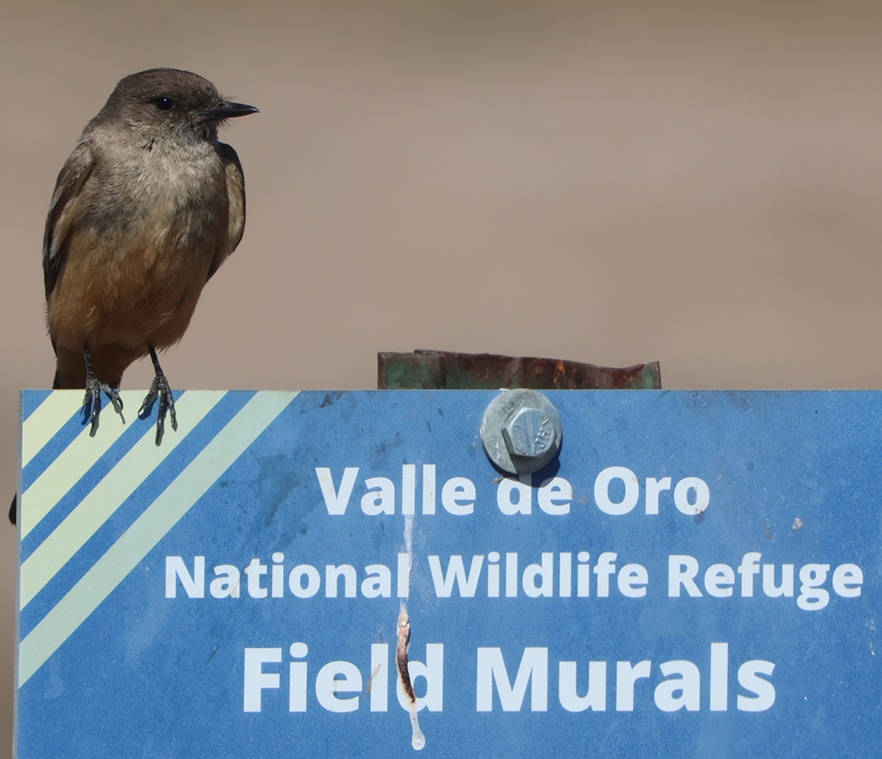
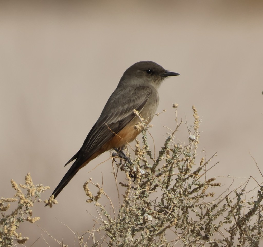
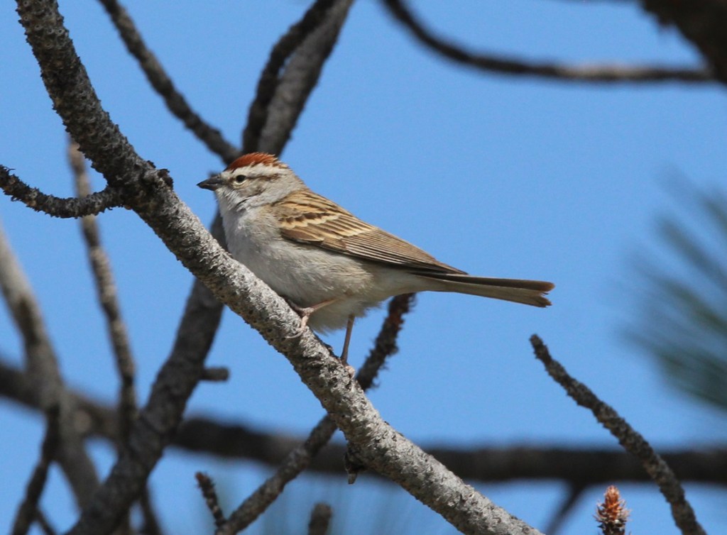
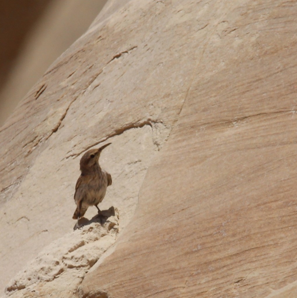
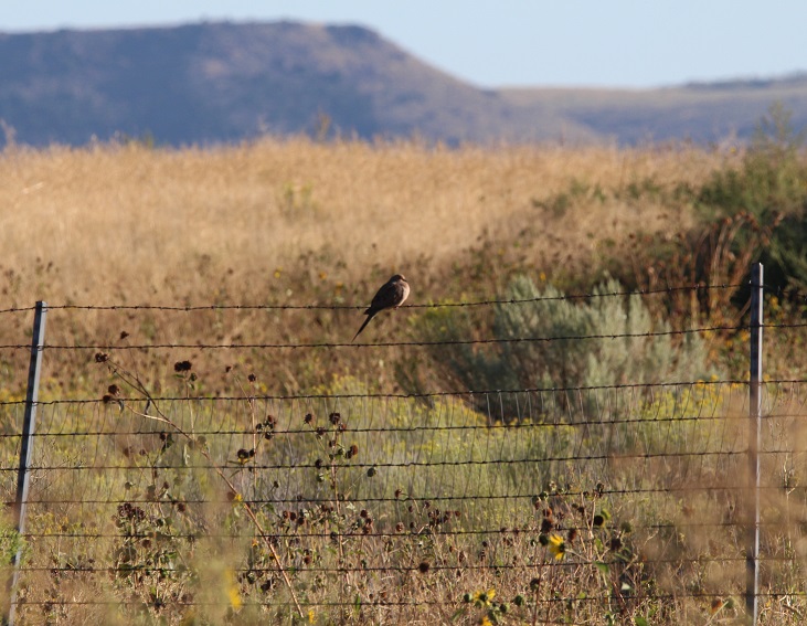
This Say’s phoebe welcomed us to the start of a hike at the refuge called the Valle de Oro Bosque Loop. “Bosque” (pr. boss-KAY) is Spanish for “forest,” and it refers to the many trees, mostly cottonwood, that line the banks of the Rio Grande just on the other side of the refuge’s western boundary.
In the case of Valle de Oro NWR, the refuge isn’t protecting undisturbed habitat that’s threatened by commercial development but rather restoring natural habitat from a formerly developed state.
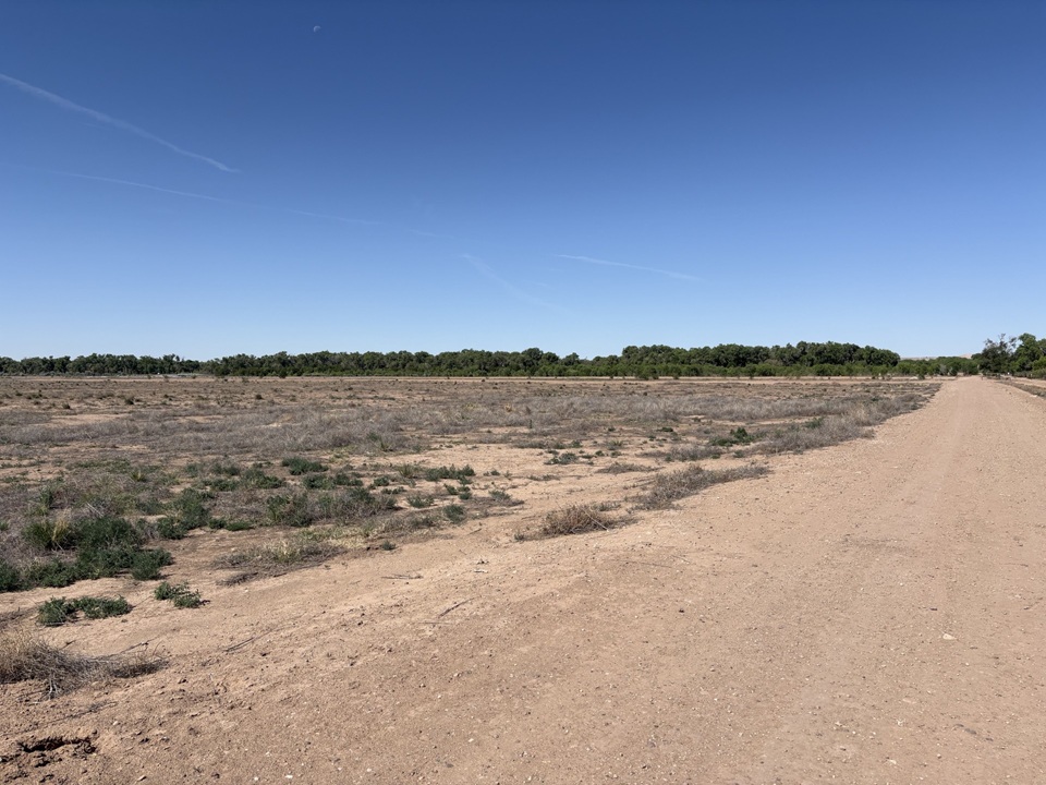
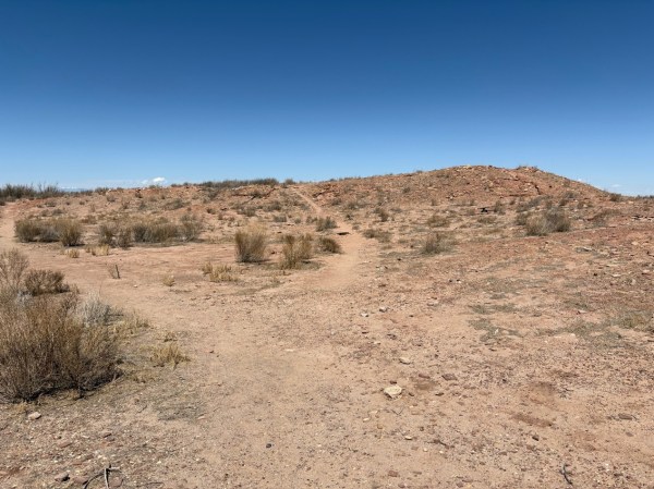
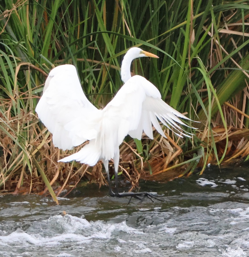
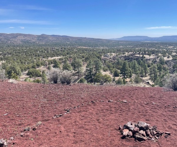
This is near the trailhead of the Valle de Oro Bosque Loop. The Rio Grande doesn’t pass through Valle de Oro NWR, but rather on the western side of the refuge. You can probably tell, from the cottonwoods on the horizon, where the water from the river regularly reaches.
Because of the ongoing drought in the American Southwest, the Rio Grande can’t even realistically be called “big”; while we were in Albuquerque in May, the river was barely a trickle as it ran through the city. When not impounded and when historically normal moisture is available, the Rio Grande flows 1,896 miles from its headwaters in southwestern Colorado, through New Mexico, forms the southern border of Texas, and empties into the Gulf of Mexico. The Rio Grande is the fourth-longest river in the United States.
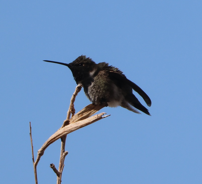
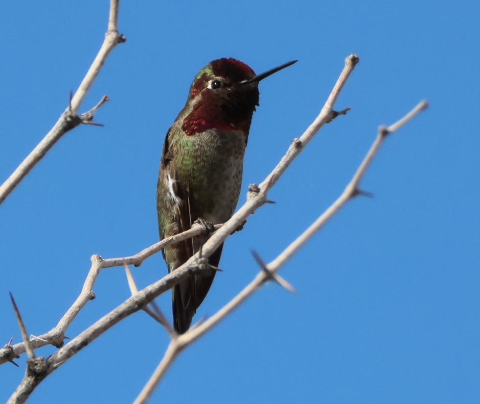
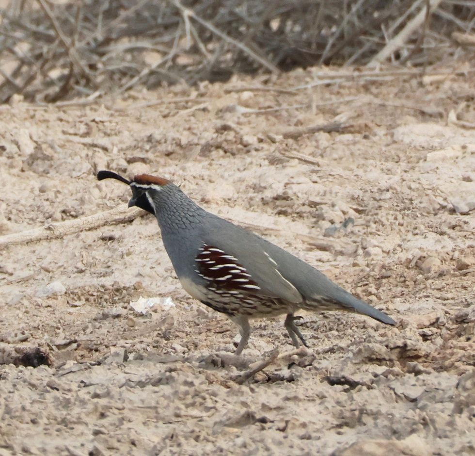
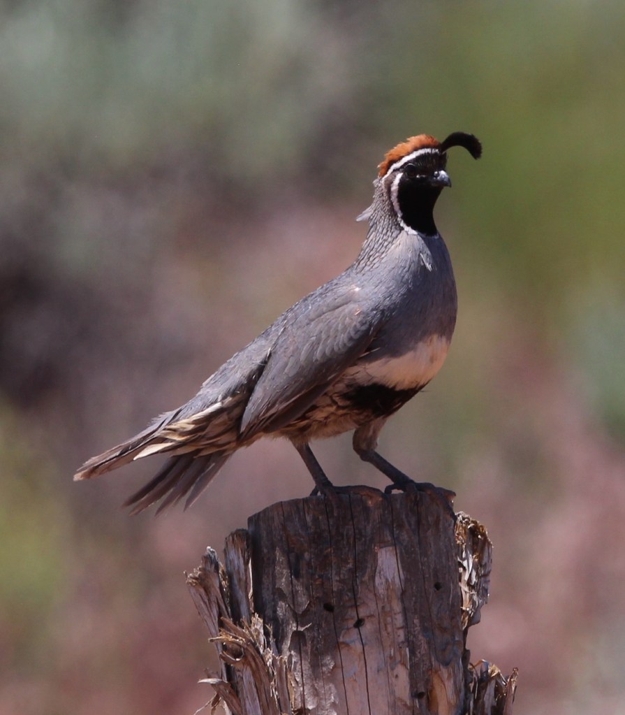
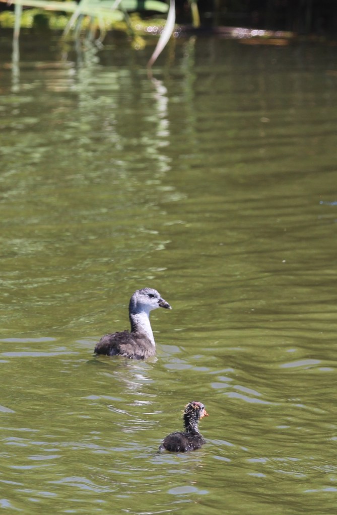
This black-chinned hummingbird (Archilochus alexandri) was making itself more comfortable on a perch just outside the front door of the refuge’s visitor center. The average heartrate of these little birds is 480 beats per minute, and in cold weather they may eat three times their body weight in flower nectar per day. They have body lengths of 3.5 inches (9 cm), weigh 0.1-0.2 ounces (2.3-4.6 g), and their wingspans measure 4.3 inches (11 cm). For comparison, a United States nickel minted in 1965 or later weighs 0.176 ounces (5 g). In good habitats, like along a river, a black-chinned hummingbird nest may be found every 100 yards (91 m) or so; their eggs are the size of coffee beans. Male black-chinned hummingbirds have a really vibrant swath of iridescent purple feathers on their chins, but those only appear when the sun hits them just right.
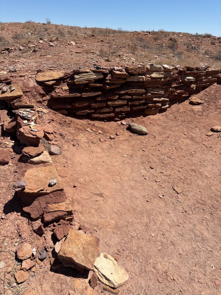
The 570-acre (just under one square mile) protected area now known as Valle de Oro NWR has a long and interesting history going back many centuries, and counts Pueblo Native Americans, Spanish conquistadors, and dairy and alfalfa farmers as those who have used its resources.
Valle de Oro NWR is among the ancestral and current lands of the Tiwa People, a Pueblo culture of Native Americans in what is now the Albuquerque area. Some of the Tiwa currently live in the Isleta and Sandia pueblos, two of New Mexico’s 19 Native American pueblos. The Pueblo culture initially developed between the years 700 and 1100, and particularly thrived between 1100 and 1300. Both Isleta and Sandia were established as pueblos in the 14th century; they were known by their Tiwa names until the Spanish arrived in the area in the late 15th century. “Isleta” and “sandia” are Spanish for “little island” and “watermelon,” respectively (more on “sandia” further down).
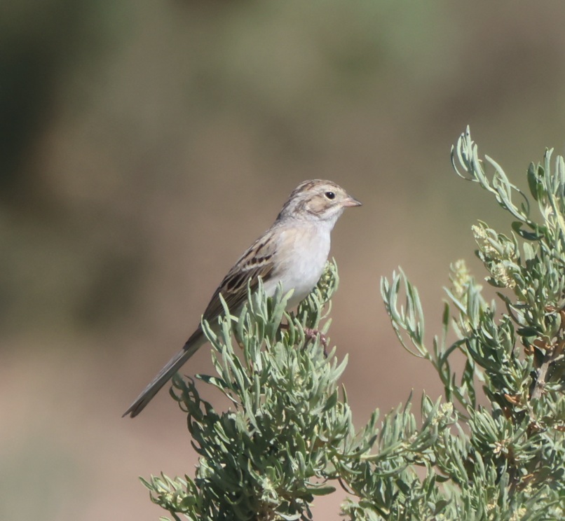
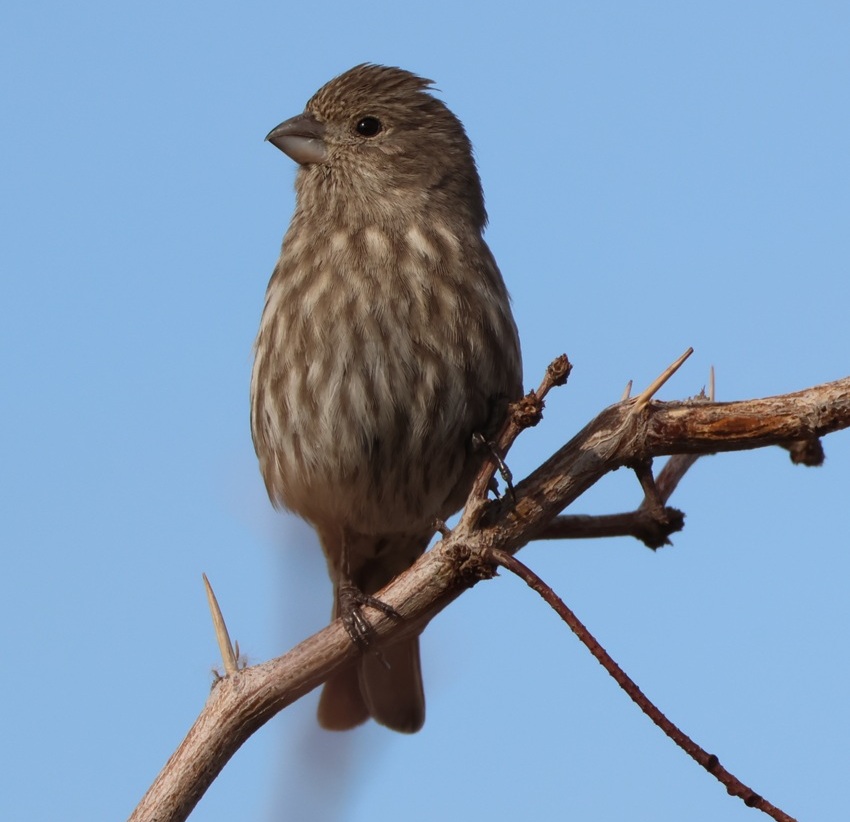
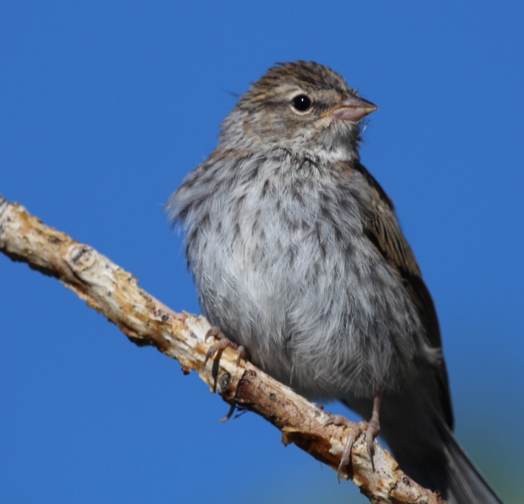
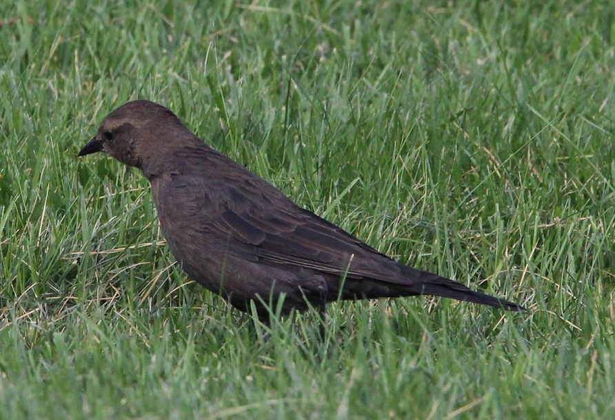
Nancy’s very good at spotting birds in the wild, and she pointed out a pair of these Brewer’s sparrows (Spizella breweri) that were perched at least 50 yards away on a sagebrush. Their size differs depending on their regional habitats, but in general Brewer’s sparrows are the smallest sparrows in North America with weights of 0.4-0.5 ounces (11-14 g). Because of a lack of defining coloration, markings, or other identification characteristics, these sparrows show why birding enthusiasts came up with the acronym of “LBB” for “little brown bird,” to serve as a temporary moniker of an individual bird until positive identification can be made.
The Spanish established a major road, El Camino Real de Tierra Adentro (“the royal road of the interior land”), that extended 1,590 miles (2,560 km) from Mexico City to just north of Santa Fe in present-day New Mexico. The road, one of four that connected Mexico City to the resources of the vast Spanish colony in America, was used from 1598 to 1882 to transport soldiers and trade goods. Much of El Camino Real still exists in the form of state highways and county roads (it passes right by one of our favorite restaurants in Las Cruces), and, back up near Albuquerque, it forms the eastern border of what is now Valle de Oro NWR.
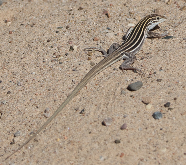
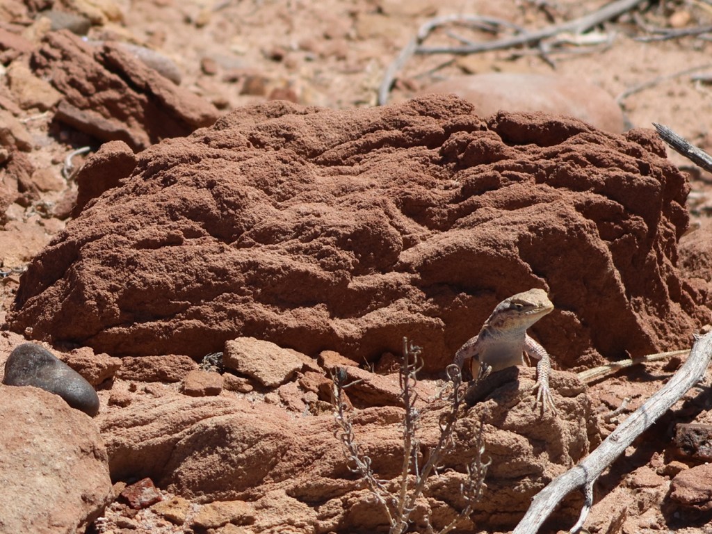
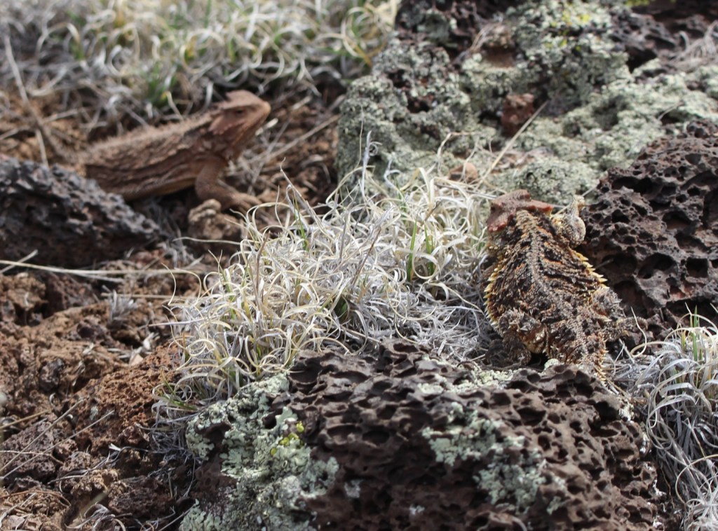
THIS IS A TALES OF THE GODDARD LIZARD ALERT. Desert grassland whiptail lizards (Aspidoscelis uniparens) live along the Rio Grande in New Mexico and in southern to central Arizona, as well as in northern Mexico. Their tails are longer than their bodies, which measure 2 3/4 to 5 1/4 inches (7.0-13.3 cm) long. They are easily identified by the six yellow stripes extending from the head and along the body. Desert grassland whiptails eat a variety of insects and other invertebrates, including ants, termites, beetles, butterflies, and grasshoppers.
Time passed, and, when Mexico gained its independence from Spain in 1821, Albuquerque changed from a New Spain outpost into a Mexican city. Albuquerque and the rest of the American Southwest became part of the United States in the mid-19th century and, in the 1930s, a family with a dairy in El Paso, Texas, expanded their operations to include a tract of land near Albuquerque. The family named the dairy “Valley Gold,” which you might, and correctly, infer (roughly) translates in Spanish to “valle de oro.” Following an increased demand for milk in the southwest after World War II, Valley Gold expanded its herd to 1,600 cows, making it one of the largest privately owned dairies in the country. The U.S. Department of Agriculture records that an average dairy cow in 1950 produced 5,300 pounds of milk each year (in 2025, an average dairy cow produced 24,400 pounds of milk annually; the industry has certainly gained some efficiencies). Anyway, dairies use a lot of water, so the Valley Gold operation developed substantial irrigation infrastructure using water from the nearby Rio Grande.
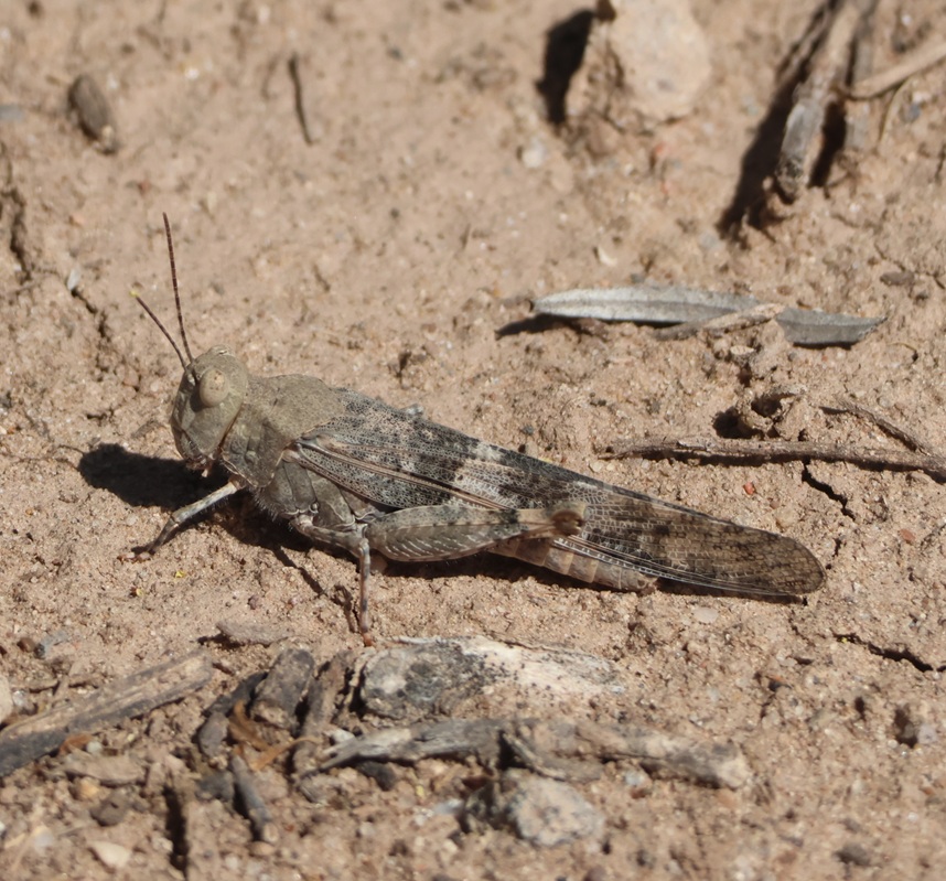
There were quite a few grasshoppers jumping about the trail as we walked. This is a pallid-winged grasshopper (Trimerotropis pallidipennis), a species common in the American Southwest. They grow to a length of 1 1/2 inches (37 mm), and their pale coloration makes for good camouflage in the dry riverbeds that they frequent.
Valley Gold ceased operations in the Albuquerque area in the late 1970s, and the property operated as an alfalfa farm (which also required a lot of water) for some time until the land was put up for sale and probable commercial development. A group of residents in the area formed Friends of Valle de Oro, a nonprofit organization that raised $9 million to buy the property and then partnered with the U.S. Fish & Wildlife Service to create the southwest’s first urban national wildlife refuge. What had been home to Pima People, part of the route from Mexico City to Santa Fe, then a dairy and alfalfa farm, was now ready to welcome back dozens of species of birds, mammals, and other wildlife to an area protected from commercial development.
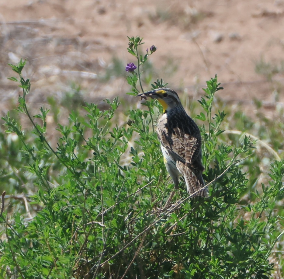
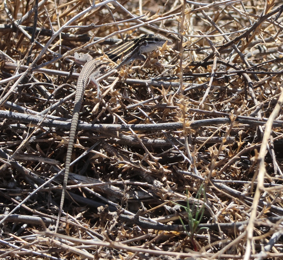
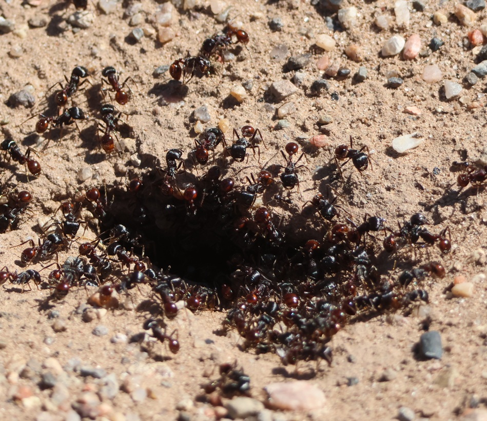
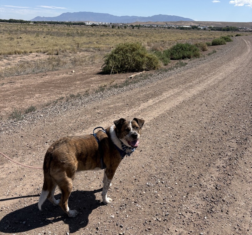
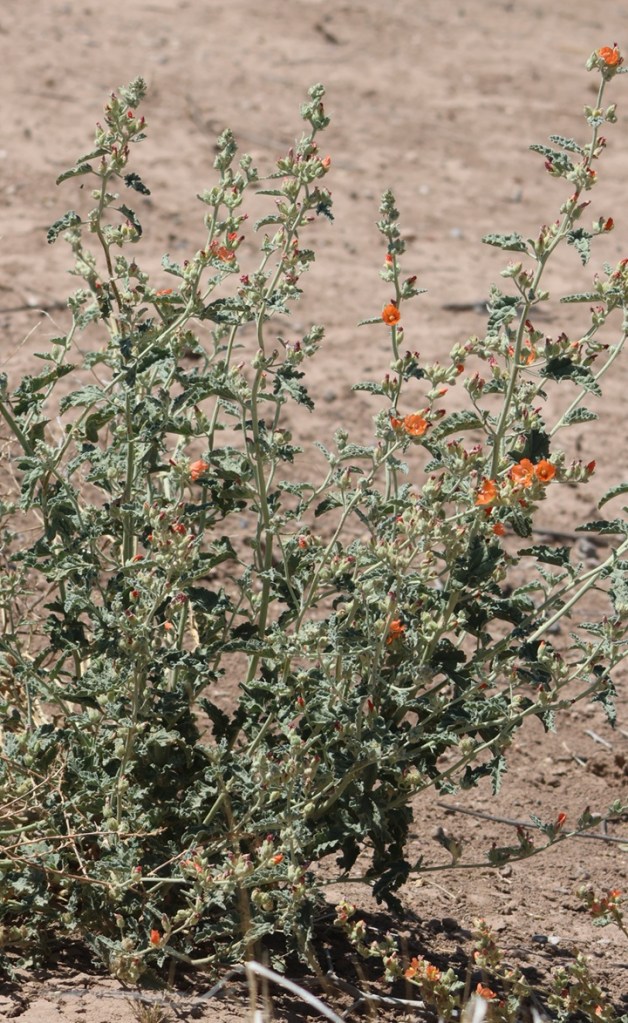
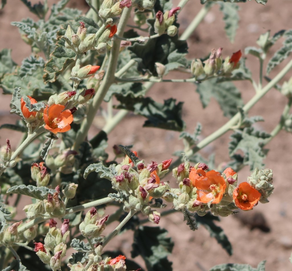
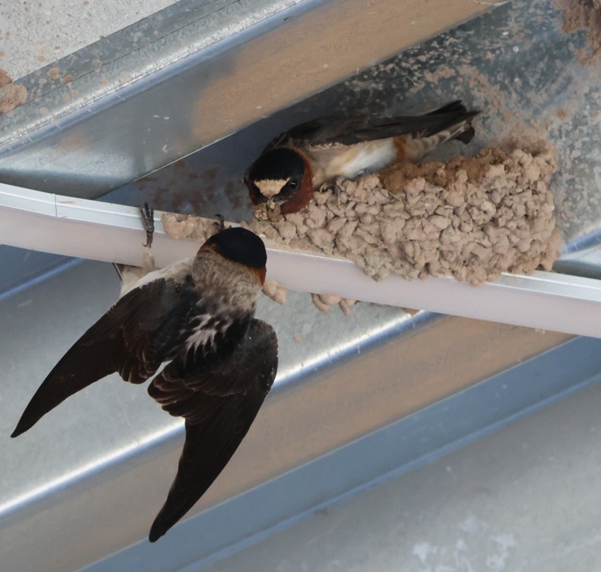
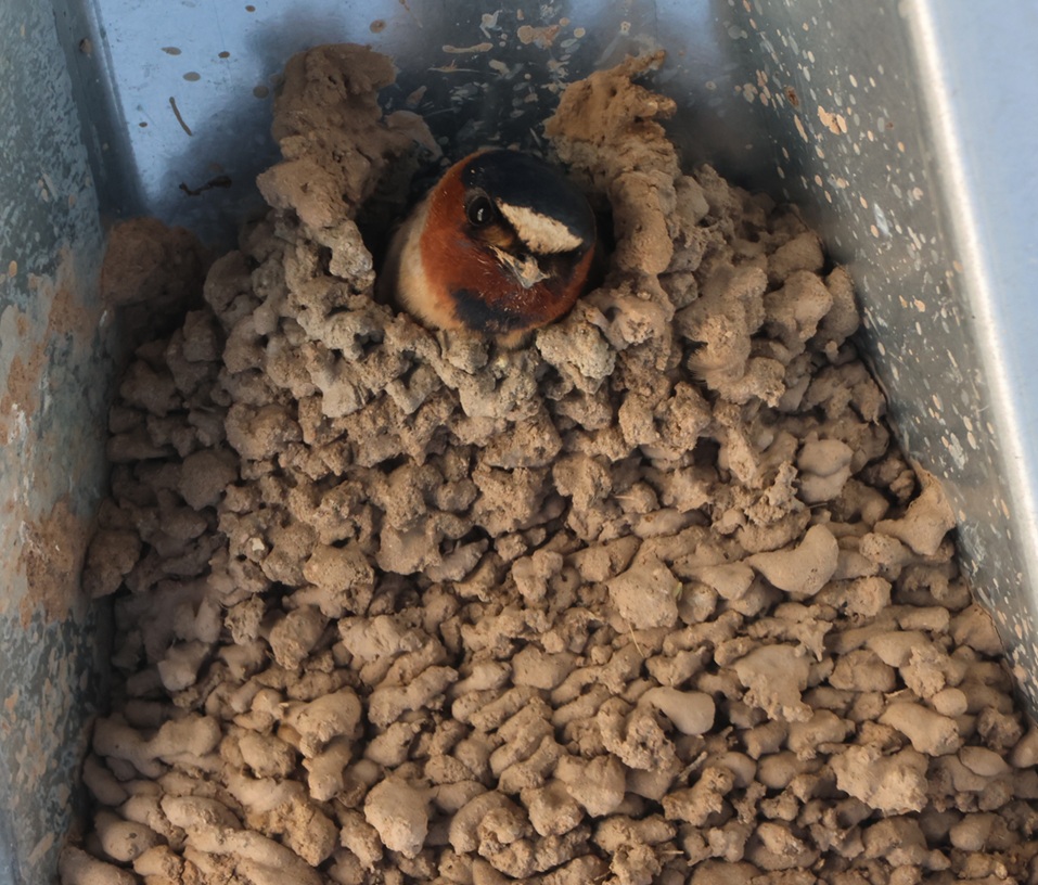
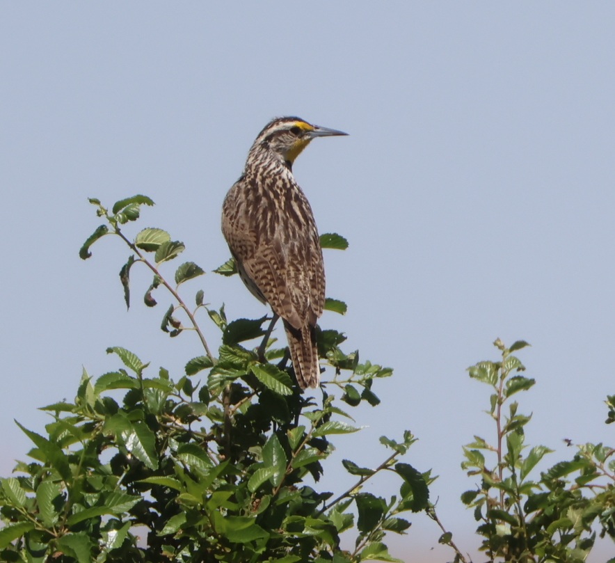
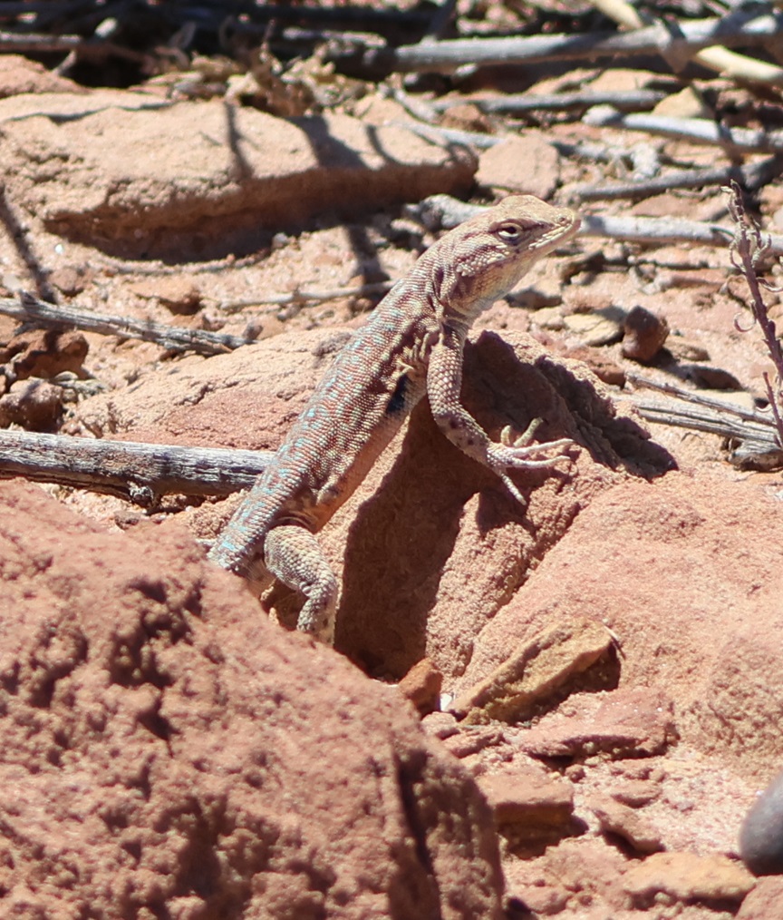
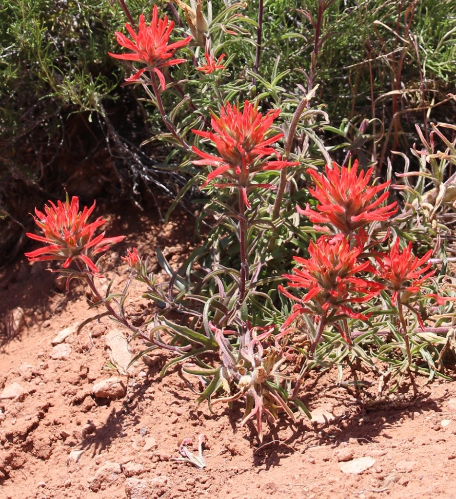
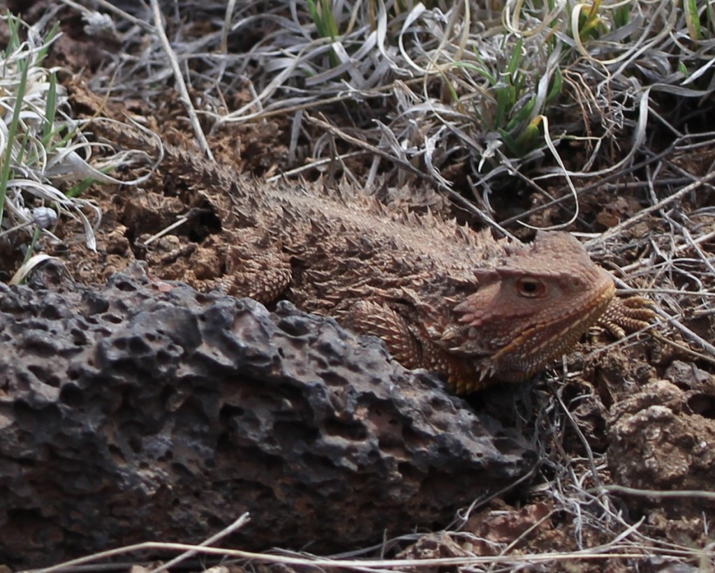
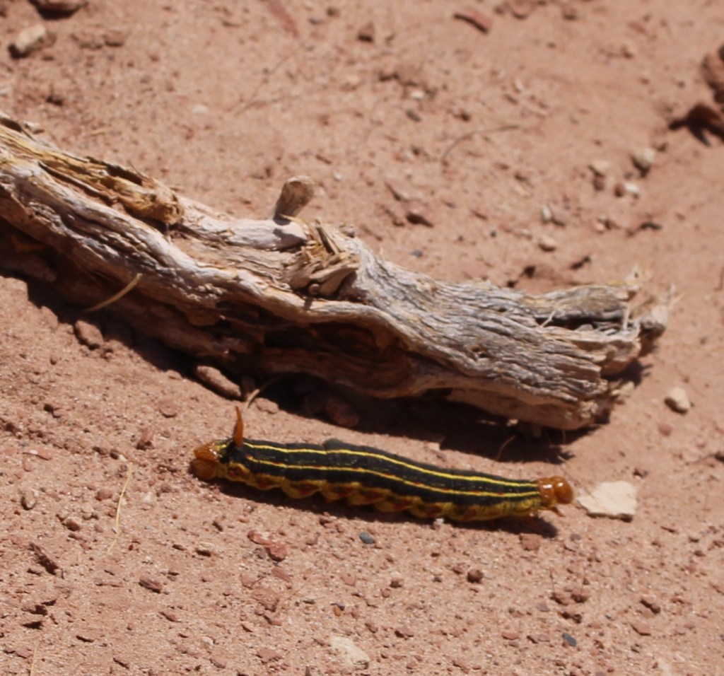
Here’s a photo of another grasshopper; this one finds itself in the unfortunate position of being in the beak of a western meadowlark (Sturnella neglecta). No less a naturalist than John James Audubon gave this bird its scientific name: “sturnella” means “starling-like,” and “neglecta” refers to Audubon’s belief that this species was overlooked by 19th-century ornitholgists. The plant on which the meadowlark is perched points to the refuge’s past: it’s alfalfa, which, due to its high protein content, comprises up to 50 percent of a dairy cow’s diet. Although the irrigation systems that served the dairy and alfalfa farms that once occupied this land are long out of use (the canals are filled with blown dirt and sand), some alfalfa plants still found enough water to thrive and bloom.THIS IS ANOTHER TALES OF THE GODDARD LIZARD ALERT and it’s another desert grassland whiptail. They’re well-camouflaged in dry desert brush like this. Albuquerque is at the northern edge of the Chihuahuan Desert, and here was a reminder that deserts have lots of sharp things like cactus thorns and ant mandibles. At one point on the trail, we stopped because Nancy had seen a bird drop from a low branch onto the ground and was attempting to spot it. I told her not to back up. lest she step into this. It’s a colony of desert harvester ants (Pogonomyrmex rugosus), which have powerful jaws and very painful venomous bites. These ants use pheromones to create invisible trails that enable other ants to follow to the colony, bringing with them plant seeds and dead insects. A few minutes before, I noticed a couple of small leaves moving on the trail in the same direction we were walking even though there wasn’t a breeze. The leaves were being carried by two harvester ants, presumably from this colony. We left the colony and continued on the trail without incident.Here’s Gunther, who enjoyed the walk with us, and here’s what much of the terrain of the Valley de Oro Bosque Loop looks like, at least away from the parts connected to the Rio Grande. Because it was used for so many decades as a dairy and later an alfalfa farm, there aren’t as many native plants as there are in other parts of the desert around Albuquerque – when water stopped being diverted from the Rio Grande, the land essentially dried up. Volunteers and NWR staff are hard at work changing that, with plantings of trees and other native plants. The buildings just this side of the mountains are in Albuquerque, and the mountains themselves are the Sandias. They rise to a top elevation of 10,678 feet (3,255 m) and are New Mexico’s most-visited mountain range. Spanish explorers gave the mountain range the name “sandia” because they seem to glow pinkish-red, like a watermelon, during Albuquerque sunsets.The mission of the National Wildlife Refuge System is “To administer a national network of lands and waters for the conservation, management, and where appropriate, restoration of fish, wildlife, and plant resources and their habitats within the United States for the benefit of the present and future generations of Americans.” Here’s an example of the plant resources: desert globemallow. Its coral-colored flowers are an extremely familiar sight to anyone in the desert southwest. I remember on a drive to the north rim of the Grand Canyon in north-central Arizona a couple of years ago, we saw millions (maybe an exaggeration, maybe not).Even though it’s very, very common, I always like seeing desert globemallow (Sphaeralcea ambigua) while we’re in the southwestern United States. Its blooms are just gorgeous, and they support the larval stages of at least five different pollinating buttterflies. The plants grow to a height of 3 feet (just under a meter), with a spread of 2-3 feet (0.6-0.9 meters). I’m writing this blog posting from our campsite in Santa Fe, New Mexico, a few days after our visit to Valle de Oro National Wildlife Refuge, and there are (very short) desert globemallow plants growing outside the Goddard.These are cliff swallows (Petrochelidon pyrrhonota) working together to build their mud nest under the roof of the refuge’s visitor center. Nancy and I estimated that there were several hundred of these swallows flitting about the visitor center and constructing their nests for the spring. These birds eat all kinds of flying insects and they are themselves incredibly skilled aerialists; I took about 50 pictures of swallows in flight at Valle de Oro and none of them turned out well because the birds were flying and turning so quickly. A staff person told Nancy that swallows lived in the huge dairy barn that used to be at the refuge, and they’ve adapted to using the new visitor center for nesting.This nest appears to be nearly complete. Each nest is built from 900 to 1,200 mud pellets, with walls that are about 1/2-inch thick. A cliff swallow clutch can include between one and six eggs, and a female swallow may lay one or two clutches during the breeding season. Cliff swallows nest near bodies of water, which provide mud for nests as well as insect habitat. Most cliff swallow colonies contain between 200 and 1,000 nests, although there’s a colony in Nebraska with 3,700 nests. It strains the mind to think about how many flying insects are needed to feed all of those birds every day. Here’s another western meadowlark that was perched about 50 yards from the refuge’s parking lot, with a link to an audio file of a western meadowlark’s call:
Whenever I hear that wonderful call, I’m reminded of meadowlarks that I used to listen to at the Denver-area office of one of my previous jobs. The parcel adjacent to the office was less than an acre but still unbroken prairieland, and it attracted quite a lot of wildlife including western meadowlarks. I enjoyed listening to them in the spring and summer months from the parking lot of my office, until construction began on that lot and it became another parking lot and commercial building. I remember being frustrated at the meadowlarks losing their habitat, and I also remember later realizing that the parking lot and building of my office was once wildlife habitat as well.
That’s the primary reason that the National Wildlife Refuge System exists: to protect wildlife habitats from development, or, in the case of Valle de Oro National Wildlife Refuge, to return commercially developed properties back into their native habitats. The Tiwa culture, the original inhabitants of this area in what is now central New Mexico, continue to play a major role in how Valle de Oro National Wildlife Refuge is managed and protected. I’m happy that’s the case.
We’ve just made our retreat from winter quarters in Las Vegas, Nevada, and now, in the first week of March 2026, find ourselves in Kingman, Arizona – just 100 miles down the road. I’ve written before about the many reasons we spend the winter months in Las Vegas, but it mostly comes down to these two:
The warmer temperatures of the Mohave Desert make the winter months both more comfortable and more practical. Cold-weather campers who stay in truck campers, travel trailers, and fifth-wheels like The Goddard know that it’s a pain – a necessary one, but still a pain – to disconnect water supplies from your RV if the temperature drops much below freezing. It’s critical to keep your water hoses, valves, and other equipment from breaking because of the frozen-water expansion. In three years totaling more than 12 months in Las Vegas, we had to disconnect from the water supply five times, and at least two of those were out of an abundance of caution.
If you run out of things to do in the literal Entertainment Capital of the World, that’s kind of on you.
There are other reasons, too, of course: frequent departures and arrivals from and to Harry Reid International Airport, through which 58.5 million people passed in 2024, allows for plenty of flights to see friends and family, there are restaurants featuring pretty much any kind of cuisine in the world, and (maybe this should be in the bullet list above) there are birding opportunities a-plenty.
Nancy and I had been to Las Vegas many times prior to selling our home in Denver and becoming full-time RVers, but our experiences in the city were pretty much limited to flying in to the airport, being transported to a hotel/casino, being entertained, and then being transported back to the airport so we could return to Denver. Having the opportunity to effectively live in Las Vegas for a quarter of the year gives us a much different perspective: people actually live, work, and raise families there – did you know that? Buying groceries, having your vehicle’s tires rotated, going to a park to escape the city noise: all of the things that people do every day in other cities are done by Las Vegans every day.
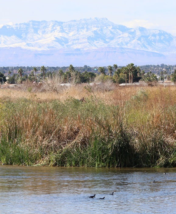
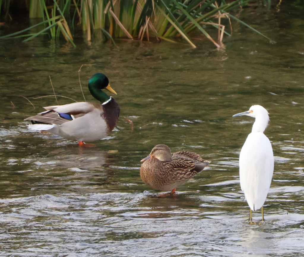
American coots swimming in the Las Vegas Wash were a familiar sight all four months we visited Clark County Wetlands Park. The city of Las Vegas (or, rather, the unincorporated towns of Paradise and Winchester; incorporated Las Vegas is itself a really small part of the metropolitan area) is on the other side of the tall grasses, and the snow-dusted mountains in the background, situated west of the metro area, show that it really was wintertime.
Maybe it’s not such a revelation to you, but, as someone who previously didn’t think about what people who actually live in Las Vegas do (you can’t make a living playing cards and going to shows, or at least not consistently), it certainly was to me.
Two of the places that we spend a lot of time while in Las Vegas are also home, or at least serve as a temporary stopover, to a number of different birds. I’ve written before about both Clark County Wetlands Park and the Springs Preserve, and they were once again sites to which we returned in the winter of 2025-2026.
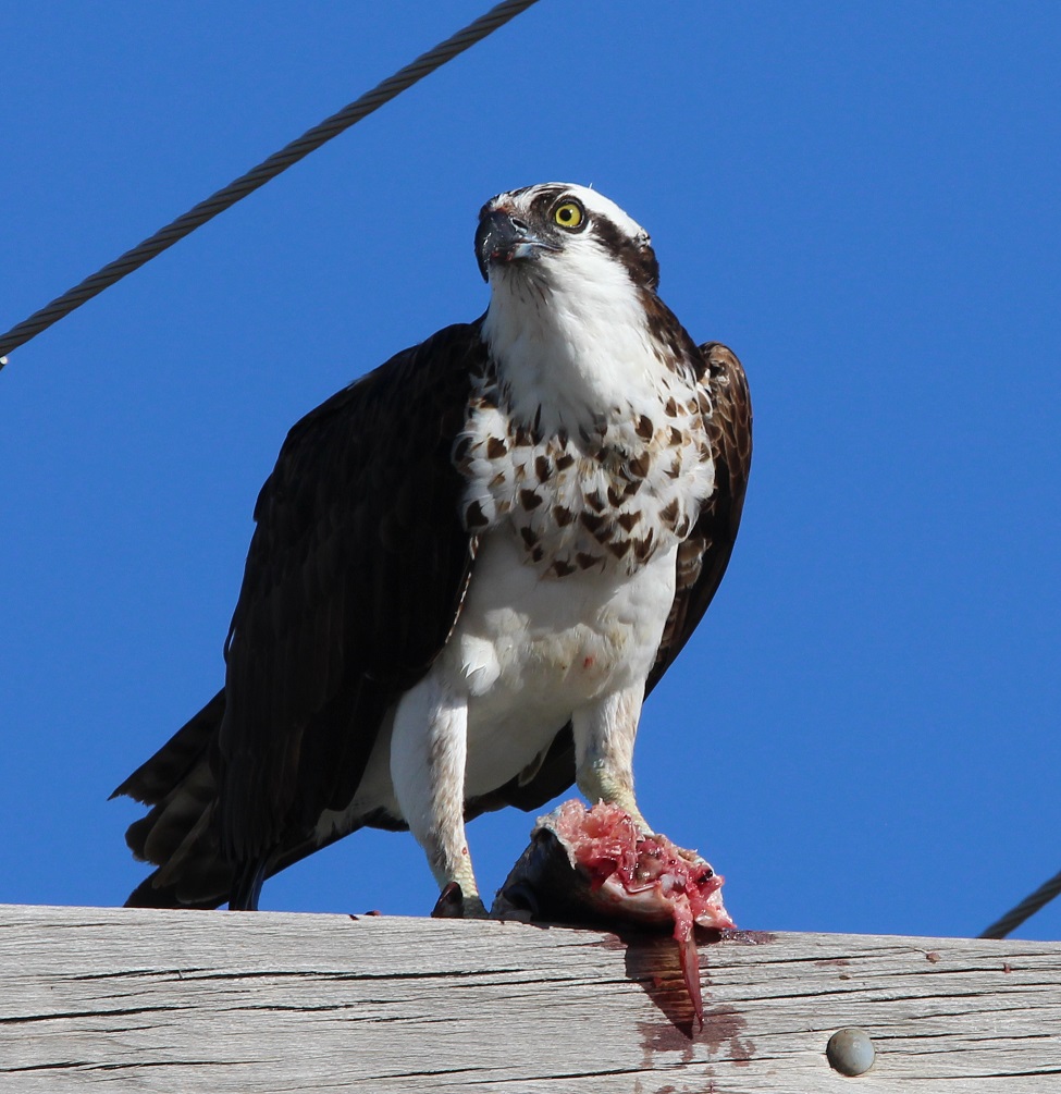
I probably took about 500 pictures of birds over the winter (I’m not exaggerating), and here, in alphabetical common-name order, are 10 species that I really enjoyed watching (I enjoyed watching all of them and I didn’t get pictures of some that I really, really enjoyed watching, like an osprey hurtling into a stream in pursuit of a fish, or an American white pelican gliding over the desert).
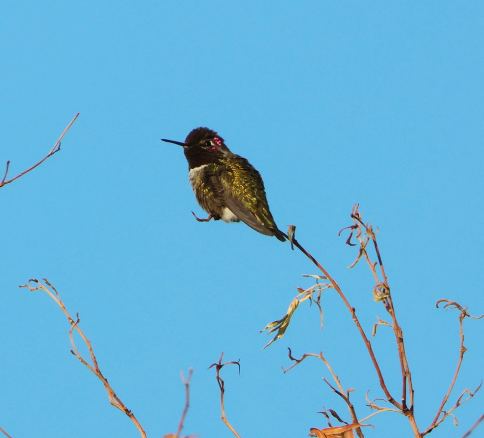
Anna’s hummingbird
Primarily because of its warm climate, Las Vegas is a year-round home, or nearly so in some instances, to four different hummingbird species. The most common is the Anna’s hummingbird (Calypte anna). These little birds have a wingspan of 4.7 inches (12 cm) and weigh only up to 0.2 oz (5.7 g). Their bodies have the volume of a ping-pong ball and the mass of an American nickel. I took this picture at Springs Preserve on February 28 near the ciénega (Spanish for “swamp”), the manmade wetland feature that recreates the original water springs around which the original townsite of Las Vegas developed. Northern mockingbirds were by far the most common birds we saw at Springs Preserve, but we saw many Anna’s hummingbirds, as well as a couple of possible other hummingbird species, that day.
We’ve stayed at the same campground in the Las Vegas area the last three winters, and there’s a dog run there with a nearby tree that usually has an Anna’s hummingbird (not the one pictured, unless it decided to fly 11 miles to this different tree) perched at its top in the mornings. Seeing that little guy is always a great way to start the day.
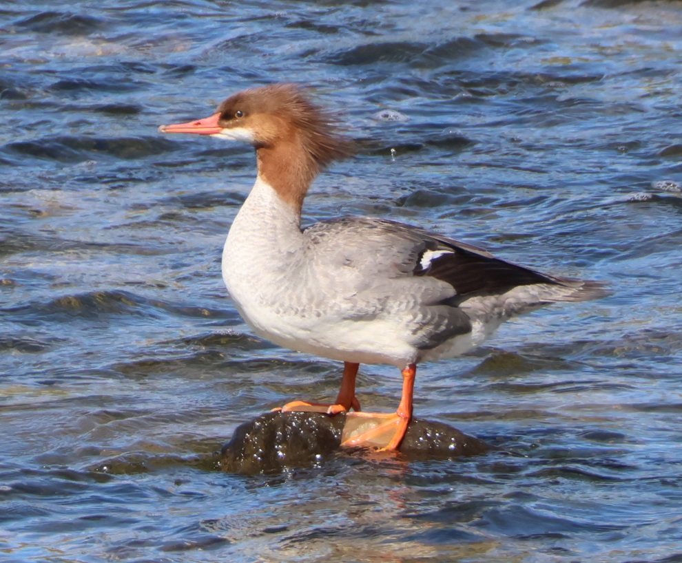
Common merganser
Nancy and I saw our first common merganser (Mergus merganser) two years ago in Pagosa Springs, Colorado, when one of these ladies (the drakes have dark-green head plumage) plopped down into the San Juan River flowing next to the restaurant at which we were dining al fresco. I got a really bad picture of it with my iPhone, but I could still tell that it was a common merganser (and a hen) because of the distinct reddish-brown head. We saw our second common merganser (another hen) paddling about the Yellowstone River during our first evening in Wyoming’s Yellowstone National Park last fall. This pretty lady pictured was one of five or six mergansers in the Las Vegas Wash on the morning of February 13. These birds have wingspans of 30-38 inches (78-97 cm) and weigh up to 4 pounds, 10 ounces (2.1 kg). All mergansers have serrated bills, which help them catch and hold on to fish. This species is found across the northern hemisphere at least part of the year; they are year-round residents of areas with ice-free water.
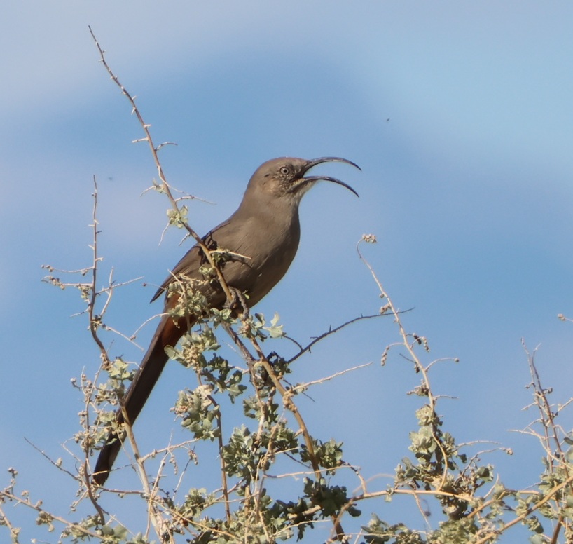
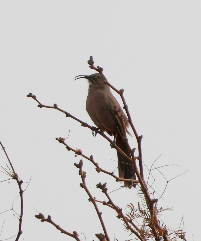
Crissal thrasher
I saw my first crissal thrasher (Toxostoma crissale) last winter at Clark County Wetlands Park, and I saw a few more there this winter; I’ve only seen them there. These birds have bodies ranging from 10.5 to 12.5 inches (27-32 cm). I’ve been a somewhat serious bird enthusiast for perhaps five years, and I’m still amazed at their diversity. Crissal thrashers’ beaks evolved into this shape to allow them to capture insects in the leaf litter at the bases of trees and shrubs. Compare this thrasher’s beak and its diet with those of the merganser (which eats fish) and hummingbird (primarily flower nectar) above. A different thrasher species, Toxostoma curvirostre, has the common name of curve-billed thrasher (we’ve seen them in Arizona and New Mexico); its bill is indeed curved, but not nearly as much as that of a crissal’s. Inexplicably, my copy of the National Audubon Society’s Field Guide to Birds has a photo of the crissal thrasher facing the camera, so the effect of that wondrous bill is completely lost.
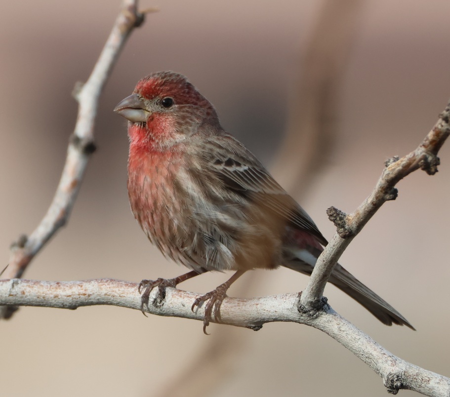
House finch
Continuing the comparisons of birds’ beaks and what they eat, have a look at these male (top) and female house finches (Haemorhous mexicanus) I photographed at Clark County Wetlands Park on January 7. For relatively small birds [5-6 inches (12.5-15 cm) in length, with an 8- to 10-inch (20-25 cm) wingspan], those are pretty stout beaks; they’ve evolved to crack open grains, nuts, and seeds with ease. Male house finches, as is the case with many (not all) birds, are more colorful than females; the red color comes from their diet. I’ve also seen orange- and yellow-colored male house finches; we saw a couple of orange ones at Springs Preserve in late February. House finches have very cherry calls and songs. As indicated by their scientific name, house finches are native to Mexico and the American Southwest. Populations were taken to the East Coast at the turn of the 20th century with the intention to be kept as house pets, but that was illegal so the owners let the birds into the wild and now the species is found over most of the United States.
Great blue heron
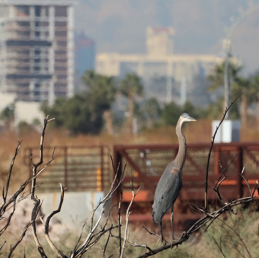
They’re usually seen standing silently on the bank of a river or lake while hunting fish, but it’s not terribly unusual to see great blue herons (Ardea herodias) find a perch (a place to rest, not a type of fish) in a tree. This particular perch was perhaps 3 feet off the ground, so I don’t think that this 45- to 54-inch-tall (115-138 cm) bird found much advantage in this position, but I’m not one to question such decisions. These are the largest herons found in North America; their wingspans measure 66-79 inches (167-201 cm). Great blue herons are found from throughout Canada down through the United States, Mexico, and South America. They are an apex predator of wetlands, where their diet includes small mammals, reptiles, and invertebrates, in addition to fish.
Some incidental notes about this photo: the brown railed structure in the background is part of the bridge that crosses the Las Vegas Wash. Most of the photos of ducks and other waterbirds in the river were taken from that bridge. The Las Vegas Wash (“wash” in the American Southwest refers to a usually intermittent riverbed) runs from the city all the way to Lake Mead about 30 miles downstream, transporting treated wastewater and runoff along the way. The water from Lake Mead finds its way back to Las Vegas via pumping stations and other infrastructure to be used again. At the top left corner is the Eastside Cannery, a 16-story hotel and casino at Boulder Highway and Nellis Boulevard, just south of the campground where we spend the winters. The 307-room property was built at a cost of $250 million and completed in 2008. The property was purchased by Boyd Gaming (owner and operator of many gaming properties around Las Vegas and the United States) in 2016. The Eastside Cannery casino and hotel closed due to COVID-19 in March 2020 and never reopened; it is set to be imploded two days from this writing (that is, on March 5, 2026).
And so it goes.
Not a bird
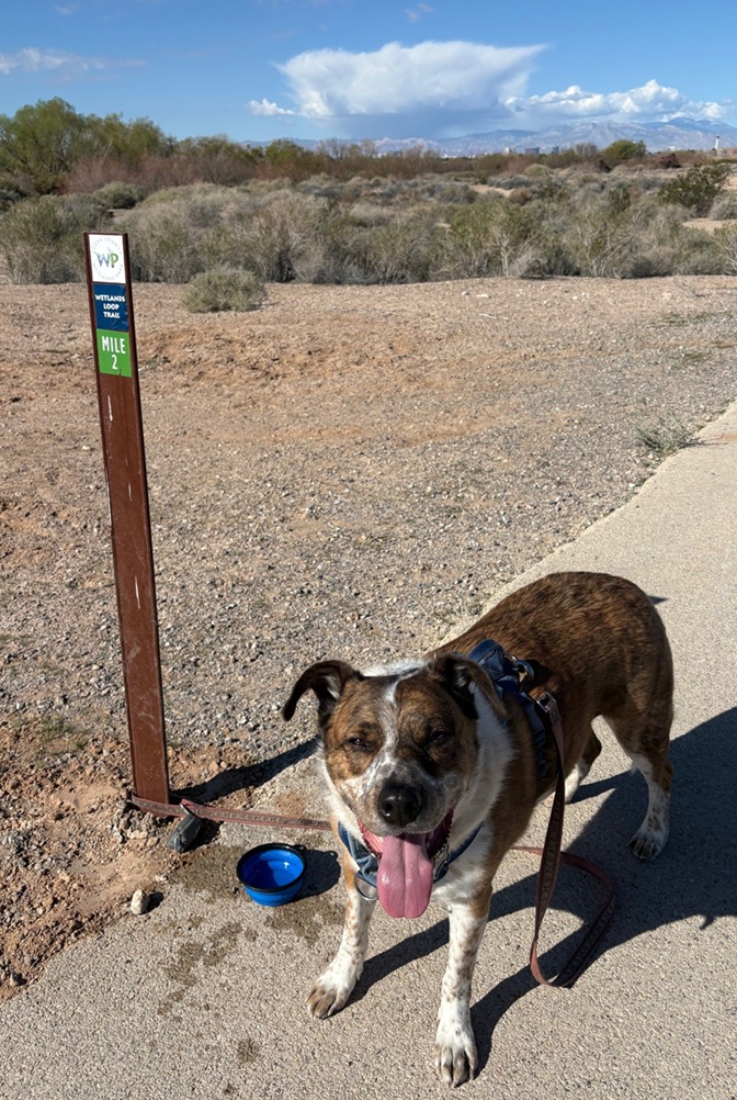
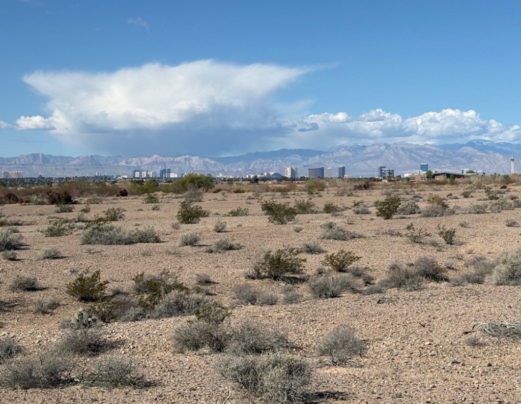
Halfway through – time for a water break! This is actually the halfway point on the Wetlands Loop Trail that Gunther and I enjoyed a couple of times this past winter. Gunther probably got at least as much water in him as he did on the sidewalk. The buildings just this side of the mountains are on Las Vegas Boulevard (“The Strip”); that’s the 1,149-foot-tall (350 m) white tower of The Strat (formerly The Stratosphere) at the right edge of the photo. It is the tallest observation tower in the United States. Readers of a certain age will remember Vegas World, a property owned by Bob Stupak that opened in 1979; some of that casino and hotel was refurbished into The Stratosphere, which opened on April 30, 1996.Here’s another photo of The Strip, taken a little later in our walk (notice the cumulonimbus cloud at left) and showing some of the Mohave Desert terrain typical of Clark County Wetlands Park when you’re not next to the water provided by the Las Vegas Wash. This viewpoint is about 10 miles east of The Strip. The white tower of The Strat is at far right; the beige Mandalay Bay is at far left (the pyramid of the Luxor Hotel & Casino is just to Mandalay Bay’s right) and about five miles south of The Strat. All of the other Strip properties, like Caesar’s Palace, Paris, The Bellagio, the MGM Grand Las Vegas, The Flamingo, The Wynn – there are 30 in all – are in between. Incidentally, the biggest hotel on the strip, the MGM Grand Las Vegas, has 4,762 rooms – more than a third of the total number of hotel rooms in all of downtown Denver. Mandalay Bay is the southernmost large hotel and casino on The Strip; The Strat, five miles north, is located within the city limits of Las Vegas and therefore, according to Clark County, not technically on The Strip.
And so it still goes.
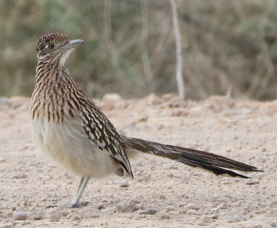
Greater roadrunner
Let’s get back to birds, with this photo I took on Jan. 23, 2026. One of the reasons I include the scientific names of birds in these postings is because they’re just fun to say. This is Geococcyx californianus, the “Californian earth-cuckoo.” The only other member of the Geococcyx genus is the Geococcyx velox (that, too, is fun to say), the lesser roadrunner, which is found only in Central America. Standing 9 3/4 to 11 3/4 inches (25-30 cm) tall, the greater roadrunner is the largest cuckoo on the American continent. Roadrunners have zygodactyl feet, meaning they have two toes in the front and two toes in the back of the foot [as opposed to most birds, which have three toes in the front and one toe in the back (anisodactyl)]. Osprey, too, are zygodactyl: the configuration allows them to carry their fish prey in the air facing forward, rather than side-to-side, for better aerodynamics. I saw this greater roadrunner while it was running on a road; it was great.
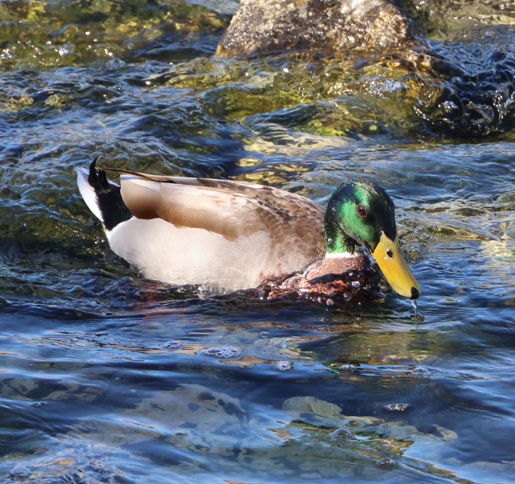
Mallard
Most readers will recognize this handsome fellow as a mallard (Anas platyrhynchos) which is one of the largest species of dabbling ducks, or ducks that feed mostly on the top of the water rather than diving down for their prey (like, say, a common merganser). Mallards are 20 to 26 inches (50-65 cm) long, with wingspans measuring 32 to 39 inches (81-98 cm). The drakes have these gorgeous green heads while hens have more restrained brown overall coloration. I’ve taken lots and lots of photos of ducks in general and mallards specifically over the last four or five years. I’ve never been as close as I was to this one when I took this on Feb. 13, 2026, from the Las Vegas Wash bridge. I’m happy with how this photo turned out. Look at that duck dabble!
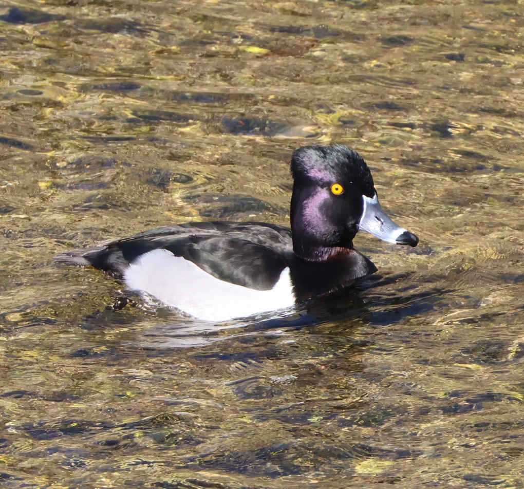
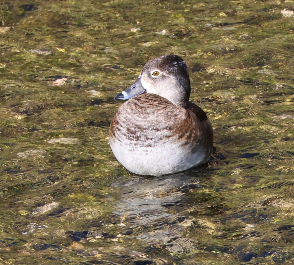
Ring-necked duck
Doubling down on ducks: these are ring-necked ducks (Aythya collaris), a drake (top) and a hen. This species is a diving duck, which, appearances aside, significantly differentiates it from a dabbling duck like the mallard. Genetic research shows that, while diving ducks and dabbling ducks may look similar in body style (morphology), they are different enough that it’s likely they evolved separately. For instance, the feet on diving ducks are placed further back on their bodies than those on dabbling ducks to help propel them underwater – but for that reason, a dabbling duck is better able to walk about on land. Don’t bother looking for the rings on these ducks’ necks: they’re very difficult to discern. This species is sometimes called a ringbill because the rings on the bills are distinct. Just look at that hen. Doesn’t she have a calming presence?
Not a bird, again
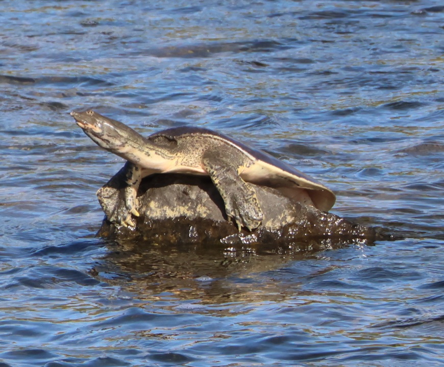
A little over a year ago, I got a new camera and lens that allow me to take photos of fairly far-away birds. With a teleconverter attached, it’s effectively around a 500mm telephoto lens. Sometimes the birds are so far away that I can’t really tell what kind of bird it is that I’m photographing. For instance, when I took the earlier photos of the crissal thrasher, I was 95% sure that it was a northern mockingbird until I got home and looked at the photos closer to full-size. Same thing happened with a loggerhead shrike this winter: I thought it, too, was a northern mockingbird until I got home. Well, this thing in the Las Vegas Wash, photographed on Feb. 13, 2026 from maybe 75 yards (68 m) away, looked to my eyes like some kind of bird so I took its picture. I was wrong. It is, as the heading indicates, not a bird. This is a Texas spiny softshell turtle (Apalone spinifera emoryi), a non-native species to the Las Vegas Wash. This is most likely a female, because a female Texas spiny softshell turtle has a carapace (something akin to a shell) measuring about two feet (61 cm) long. The species is naturally found in the Rio Grande and Pecos river drainages of Texas and New Mexico, but someone (likely) released this species into the Las Vegas Wash some time ago and now they’re pretty well established. This is yet another reason that I will never dip my toe in the Las Vegas Wash.
Verdin
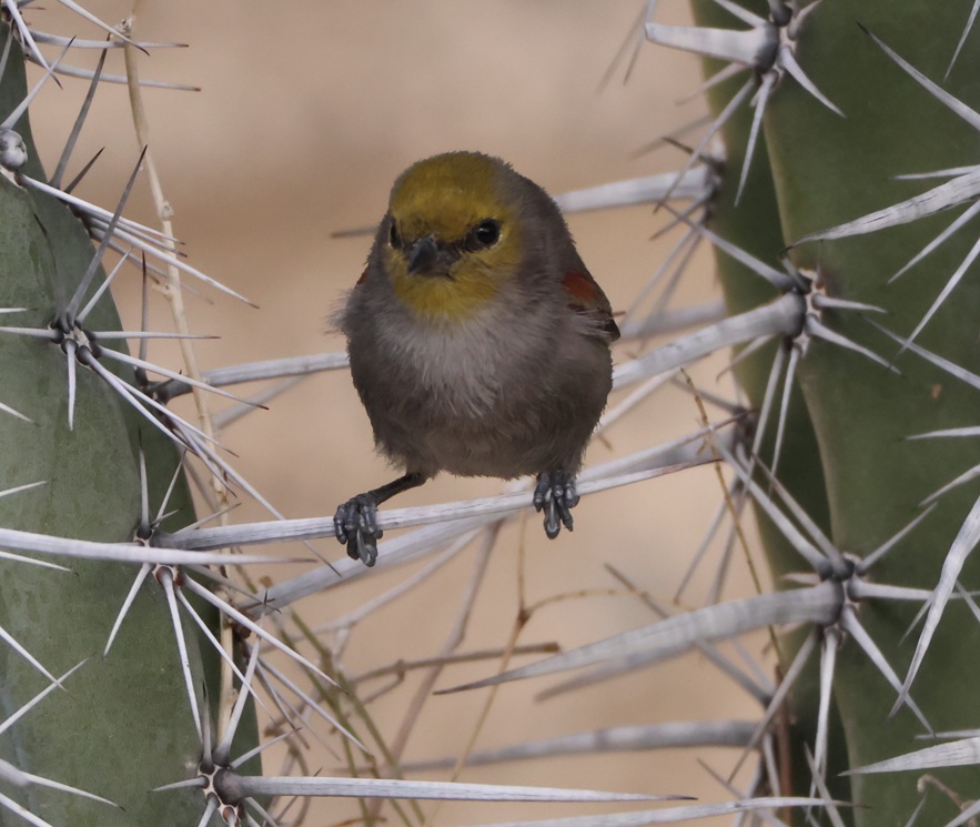
Let us turn away from turtles and return once again back to birds. This was one of the last birds I photographed in our winter in Las Vegas. It was one of four or five verdins (Auriparus flaviceps – that one’s fun to say, too) at Springs Preserve on Feb. 28, 2026, that were flitting back and forth between a tall tree and this good-sized pipe organ cactus. I was finally able to get a couple of decent photos when this one settled for a bit on a cactus thorn. That’s a good-sized thorn: a verdin is only 4 1/2 inches (11 cm) in length. I got some decent pictures of verdins over the winter at Clark County Wetlands Park, but I’m happy with this photo (and I’m also well-aware that it is 95 percent luck). We saw several of these beautiful little birds entering and exiting their nests while at Springs Preserve: it’s an exciting time of year!
White-crowned sparrow
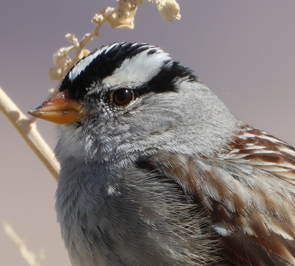
As I noted above, I have a camera that lets me get photos of far-away subjects. It also works pretty well when the birds are relatively close. At the trailhead of the Wetlands Loop Trail at Clark County Wetlands Park, the sidewalk goes by a lot of shrubs called four-wing saltbush. Those shrubs provide a favored perch for white-crowned sparrows (Zonotrichia leucophrys), who usually let Gunther and me walk on by, without taking off, when we’re on the trail. I was able to photograph a juvenile (top) and adult from a very close perspective. White-crowned sparrows are among the most gregarious wild birds I know, and the ones that hang out next to the Wetlands Loop Trailhead are perhaps the most sociable I’ve ever seen. Maybe it’s all the foot and bike traffic they see during the day, but it was great to be able to get these detailed photos for a close look at their feathers and coloration.
One of the things that really appeals to be about birdwatching is being able to see the similarities and differences between species: the coloration (some species have wildly different color patterns between males and females, for instance); the differences in size and shape of beaks/bills, wings, and tails; even noting that in some species, like ring-necked ducks, the drakes have bright yellow eyes and the hens have beautiful brown eyes. All of the birds in this posting were photographed within no more than 15 miles of each other: the riparian habitat at Clark County Wetlands Park brings a lot of birds to Las Vegas that wouldn’t normally stop there, and there’s great diversity even between the native desert birds like crissal thrashers and hummingbirds.
I keep a list, beginning on Jan. 1 of each year, to keep track of how many different bird species I see during that year. My goal is always 100 different species, and I’ve never met it (I got to 94 in 2023, 62 in 2024, and 96 in 2025). In the first two months of 2026, I’ve recorded 36 different species, all of which were observed in either Clark County Wetlands Park or the Springs Preserve in Las Vegas. With a 3,000-mile trip scheduled through the American Southwest, Midwest, and Upper Midwest, along with a 3,000-mile trip back to Las Vegas in the fall, I’m feeling pretty good about my chances of meeting my goal of 100 observed bird species this year. I hope my little Anna’s hummingbird pal is back on top of his tree next to the dog run when we return to Las Vegas in December.
Bird species observed in the Las Vegas, Nevada, area in January and February 2026
Homolovi State Park, near Winslow, Arizona April 16, 2025
We’re camping for two weeks in Homolovi State Park, just a couple miles east of the town of Winslow, Arizona (pop. 9,005; perhaps you’ve heard of it – one of its street corners is mentioned in the Eagles’ first major hit from 1972, “Take It Easy”). This is our third time staying here in three years – we really enjoy it. After spending five months wintering in Las Vegas, Nevada, and then a couple of campgrounds on Interstate 40 in Arizona, we’re appreciating the quiet environment and dark skies of this state park (not that we didn’t have a good time in Las Vegas; in fact, we’ve reservations to be back there beginning this November).
The main feature of this state park is a cluster of four major ancient Native American villages, several miles apart and all built and occupied around the years 1290-1400. The villages were then abandoned, but it’s generally understood that the people who lived here eventually became what is now the Hopi nation – one of the tribe’s reservations is about 60 miles north of present-day Homolovi State Park. The four villages are designated Homol’ovi I-IV; the name of the state park doesn’t include the apostrophe of the village names. “Homol’ovi,” in Hopi, translates to “place of the little hills,” and the Hopi also refer to the city of Winslow as “Homol’ovi.”
The Hopi call the people who lived here – most likely their ancestors – the Hisatsinom, which means “the people of long ago.” During the period in which the Hisatsinom lived in this region, they built and occupied four or five large villages – some comprising hundreds of rooms – using rocks gathered from the ground.
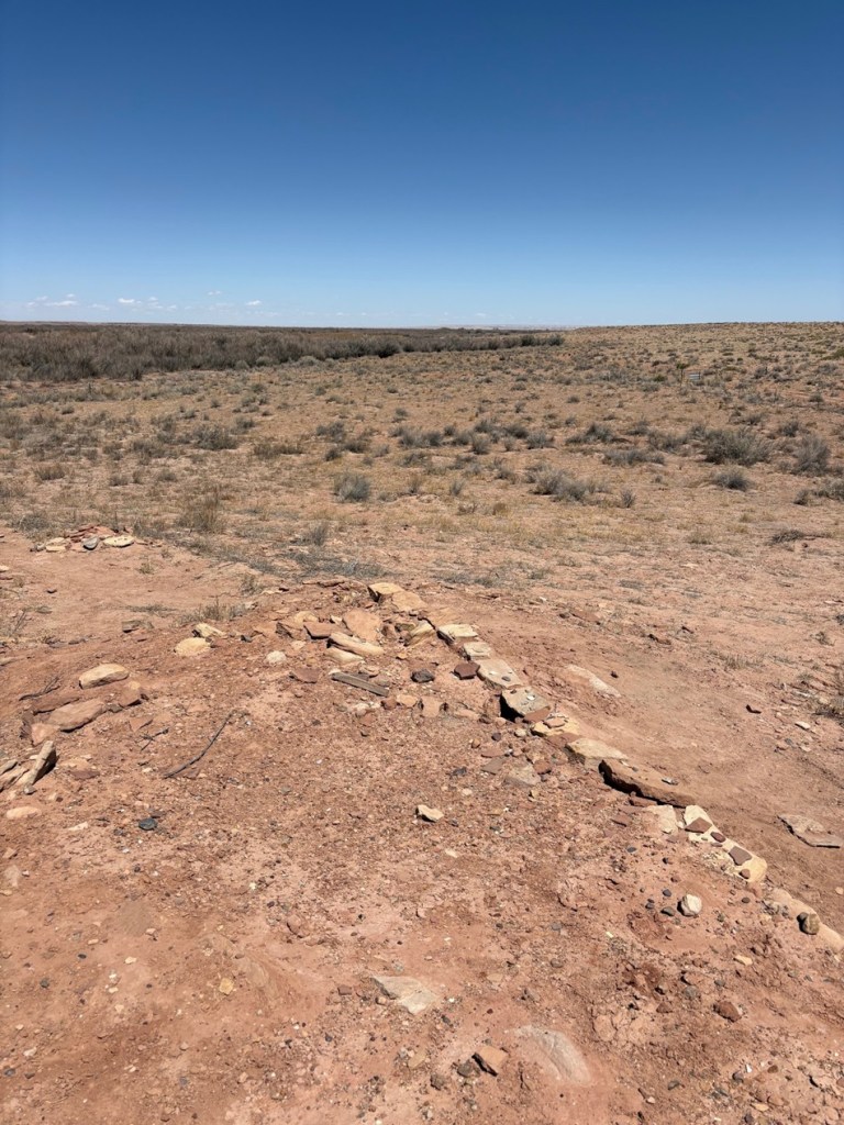
The Little Colorado River, a watercourse that drains the Painted Desert area of northeastern Arizona, flows through Homolovi State Park. I took this photo while Nancy and I were driving to Winslow; the perspective is looking north from a bridge on the former U.S. Route 66 (and now Arizona State Highway 87). The trucks and trailers just on this side of the horizon are on Interstate 40. The Little Colorado River’s headwaters are in the mid-eastern region of Arizona, very near the state’s border with New Mexico. It then flows almost 340 miles in a northwestern direction until it empties into the Colorado River in the Grand Canyon. The river flows from its headwaters all the way to the Grand Canyon only during periods of flash flooding or heavy snowmelt; much of the year it’s a braided and puddled wash. I took this photo the day after the area got some appreciable rain and snow, and the water level rose only marginally. The occasional flash flooding of the Little Colorado River, which swept away crops and structures, is probably why the Homol’ovi sites were abandoned in favor of the area further to the north and which the Hopi call home today.This is the site of a major native American village, known now as Homol’ovi I, that was last occupied about 600 years ago. At its peak, it contained about 1,100 different rooms constructed of rocks. Some of the rooms included three stories. Over the ensuing six centuries, a lot has happened to destroy these unoccupied villages. Dependable northern Arizona winds have covered the village with dirt and sand, but some structures, such as the one on the mound at the right, can still be discerned. Many of the rocks in the structures were taken by members of a nearby Mormon community in the late 1800s for use in their own buildings, and vandals have also destroyed the buildings and looted the pottery.
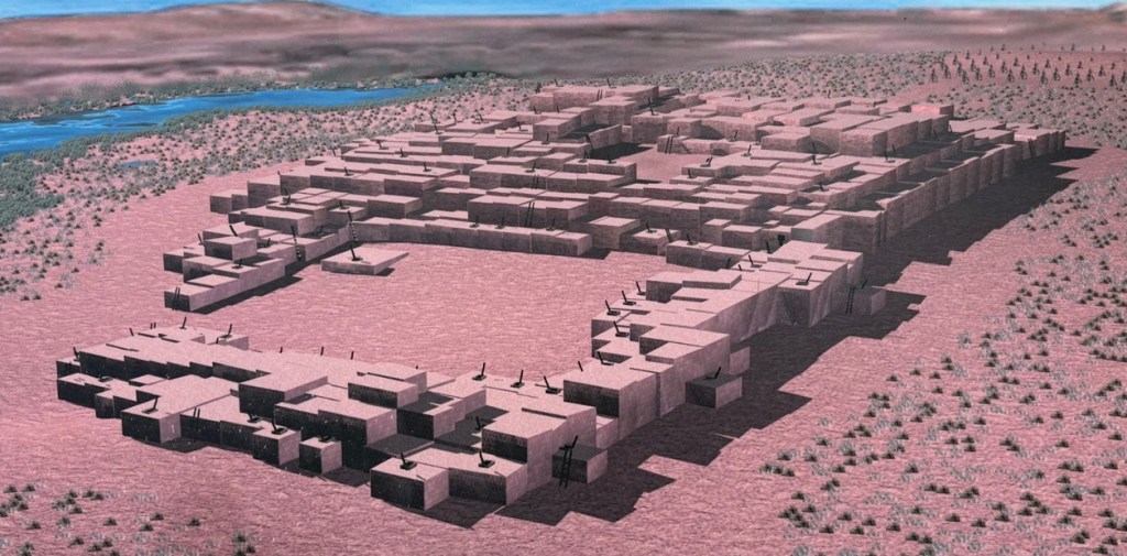
Take a look at the tall plants on the horizon at far left: directly to the right of them, you’ll see some white splotches (not the clouds, which are further to the right; the smaller white splotches of which I write are immediately to the right of the tall plants). Those are the San Francisco Peaks, still snow-covered in mid-April. The town of Flagstaff, Arizona, is at their feet. Those mountains are about 65 miles west of Homolovi State Park.I took a picture of this image, an artist’s depiction of what Homol’ovi I looked like at its peak, at an information kiosk near the site of the former village. That’s the Little Colorado River in top right. The original image gives credit to Douglas Gann of the Center for Desert Archaeology.
From about 1290 to 1360, it’s believed that Homol’ovi I grew from a village of 200 rooms to more than 700. Around the year 1360, the village now known as Homol’ovi II was established about 3 miles, or 5 kilometers, north of Homol’ovi I; that second village quickly became the biggest one in the cluster at 1,200 rooms. Homol’ovi I, however, benefited from the second village’s success, and grew to a maximum of 1,100 rooms.
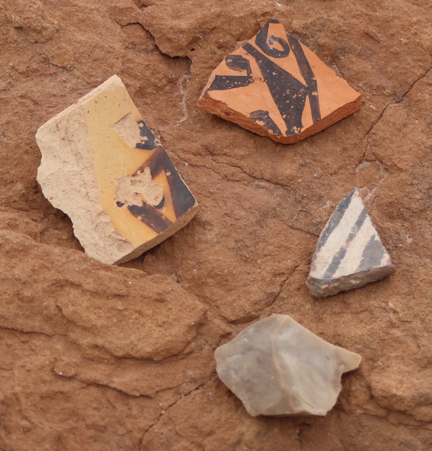
This photograph was taken from the top of the hill shown in the previous photo, still looking to the northwest. The rocks in a line are the former wall of a room. The trees near the horizon are on the east bank of the Little Colorado River; it was that river’s occasional flash flooding that likely led to the abandonment of Homol’ovi I and the other villages 600 years ago.This is a small grouping of pottery shards and what appears to be a hand-shaped rock, taken from the ground at Homol’ovi I and placed on a larger rock. The pieces of pottery are roughly the size of an American half-dollar. There are thousands of shards like these at the site, and most of them are on larger rocks like this. Archeologists and conservationists prefer that people don’t do this; instead, simply leave the shards on the ground.This is the largest exposed wall still standing at Homol’ovi I, and it’s been almost entirely rebuilt by archeologists. Note the small collections of pottery shards on some of the rocks at left: don’t do that.THIS IS A TALES OF THE GODDARD LIZARD ALERT. This little guy (and he is a guy, and I’ll tell you why I know shortly) caught my eye as he scampered across the rocks and sand of Homol’ovi I. He is a side-blotched lizard, a genus (Uta) of which there are now seven species, and he and I were to have kind of a neat interaction. This photo of my new reptile pal shows why the genus is called side-blotched lizard – observe the dark mark (or, in scientific terminology, “blotch”) on its side just behind its front leg. The turquoise-blue dots on the back are also a defining characteristic of the genus. These lizards grow to a length of about six inches, including the tail. Their diet includes insects, spiders, and other arthropods such as the occasional scorpion. They are themselves predated upon by larger lizards and roadrunners.In an attempt to give the reptile some space, I continued walking down the path through Homol’ovi I – but the beast pursued me. Observe the very pretty light-blue dots on its back. I was about six feet from the lizard when I took this photo (using a 400mm telephoto lens).Here’s a cropped version of the previous photo. Behold those beautiful blue dots as well as some detail of its fearsome front claws. After I took the photo, the lizard continued to approach me: in fact, it got to about six inches from my left foot – and then it scampered away. Turns out, that’s a common behavioral trait of male side-blotched lizards. The scientists don’t know if the behavior is intended to scare away possible intruders from its mate, or to defend its territory. At any rate, I got the hint and moved along (even though my course on the path took me in the same general direction of the lizard, who at that point was many yards away). I later described my interaction with the side-blotched lizard to Nancy, who did not at all appreciate when I poked her under her armpit to show her where the blotch on the lizard’s side was. We also shared the same belief that she would have absolutely and completely freaked out if the lizard had gotten to within six inches of her left foot.More wildlife: I always like to include some bird photos in these postings, so here are a couple of images I took in our campground at Homolovi State Park. This is a black-throated sparrow (Amphispiza bilineata), a species found in the southwestern United States and much of Mexico. They are absolutely beautiful little birds. I’ve seen them only here at Homolovi State Park and at Tuzigoot National Monument, further west in Arizona.This is a loggerhead shrike (Lanius ludovicianus), on a tree just a few feet from the Goddard’s campsite. I remember reading about shrikes when I was young, but I didn’t see one in the wild until a couple of years ago at McDowell Mountain Regional Park east of Phoenix, Arizona. I also saw some over this past winter at Clark County Wetlands Park, very close to the campground where we spent the winter near Las Vegas. Loggerhead shrikes are found nearly all over the United States.
We’re planning to join a ranger-led tour of Homol’ovi II, which has been partially excavated and reconstructed, on Saturday, April 26. I’ll write and post photographs from that experience afterwards. We were on the same tour a couple of years ago, but, because of our travels and opportunities to see ancient Native American sites in the southwestern United States since then, we have a better perspective of what we’ll see.
Nancy, Gunther, Rusty, and I are wintering in Las Vegas, Nevada. We arrived here at the beginning of November 2024, with plans to depart in early spring of this year. There are worse places to spend the winter than Las Vegas: the campground at which we’re staying is surprisingly inexpensive with friendly folks and lots of activities, there are a lot of good restaurants and entertainment options relatively nearby, and, as we found out last winter (we spent five months here), there are a unexpectedly large number of hiking and birding opportunities very close to the city.
Gunther, Nancy, and I took advantage of one of those birding opportunities during the waning days of 2024 with a visit to Clark County Wetlands Park, located just a few minutes’ drive from our campground. The Las Vegas Wash, which I described in last year’s posting about the Owl Canyon Hiking Trail at Lake Mead National Recreation Area, creates the wetlands aspect of the park. Those of you who have spent much time in the desert city of Las Vegas might be surprised to see that a decent-sized creek runs through the east side of the metropolitan area. Las Vegas Wash is bigger at times, especially after heavy rains, than others. For those used to even small-sized creeks and rivers, it’s probably not a very impressive waterway. However, the Las Vegas Wash is absolutely critical for the health and sustainability of this area; the water in it is collected wastewater and runoff from the city’s hotels, golf courses, and other businesses, as well as residential wastewater and stormwater runoff, on a 12-mile journey (including through wastewater treatment plants) to the Lake Mead impoundment east of Las Vegas. Ninety percent of the water used in the Las Vegas metropolitan area is drawn from Lake Mead (the rest is from groundwater sources), so it’s imperative that as much water that’s used in the city gets returned to the reservoir as possible.
We’re currently close enough to the Golden State that I thought this might be a California quail as opposed to a Gambel’s quail (Callipepla gambelii), but it is indeed the latter. It, along with three or four more of its kind, was hunting on the ground just off the trail shortly after we started our walk. In addition to southern Nevada, this bird’s range includes regions of California, Arizona, New Mexico, and Utah, as well as little parts of western Colorado.
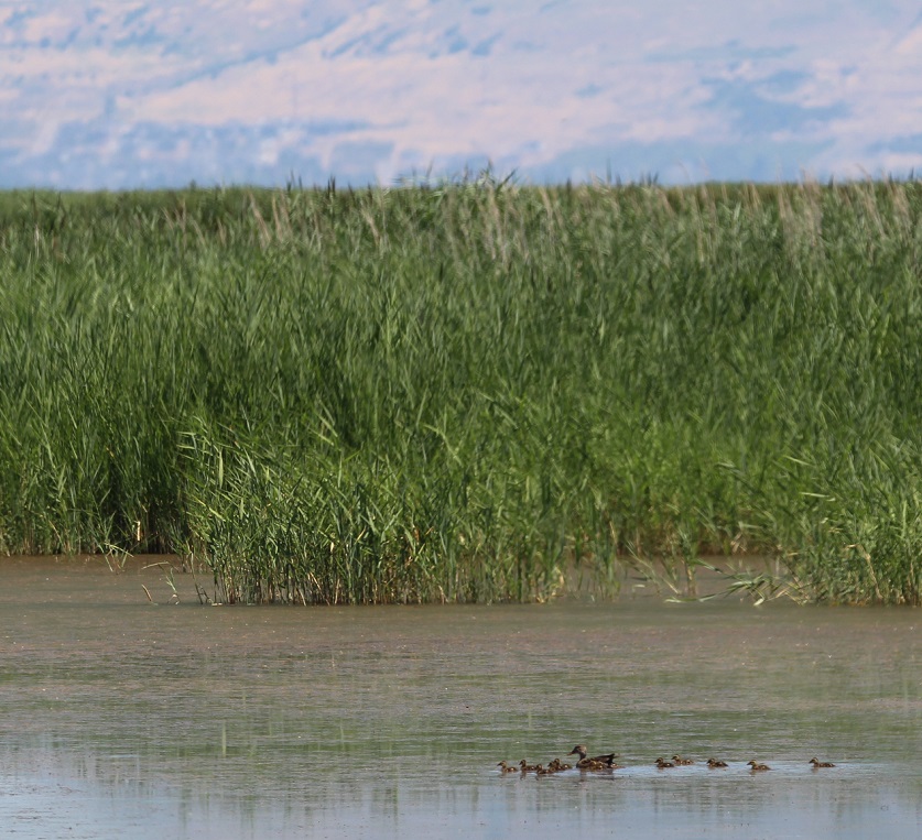
Whether it’s moving, still, salty, fresh, or freshly treated, water makes a huge difference in supporting wildlife populations; without the wash, many species of birds, lizards, and mammals simply wouldn’t be in this place. That fact was made clear to us on the day that we visited. Like most avid birders, I keep a record of each bird species we see during the year. Before we began the five-mile loop walk through the wetlands, we’d seen 50 different bird species in 2024; by the time the three of us climbed back into the Goddard’s six-wheeled towing unit to drive back to the campground, we’d seen 18 additional species, 12 of which were species not yet seen in 2024, and four of which we’d never seen before. In other words, nearly a quarter of the bird species we saw in 2024 were seen on the on the 363rd day of the year during this 2 1/2-hour hike just outside of Las Vegas.
Much of the 2,900-acre (4.5 square-mile) Wetlands Park is a nature preserve, into which Gunther (very understandably) can’t go. However, there’s a very fine concrete trail that skirts the outer perimeter of the preserve and also goes over a bridge that crosses the wash. It was from that bridge that we saw three of the four “lifers,” or bird species we hadn’t ever seen before.
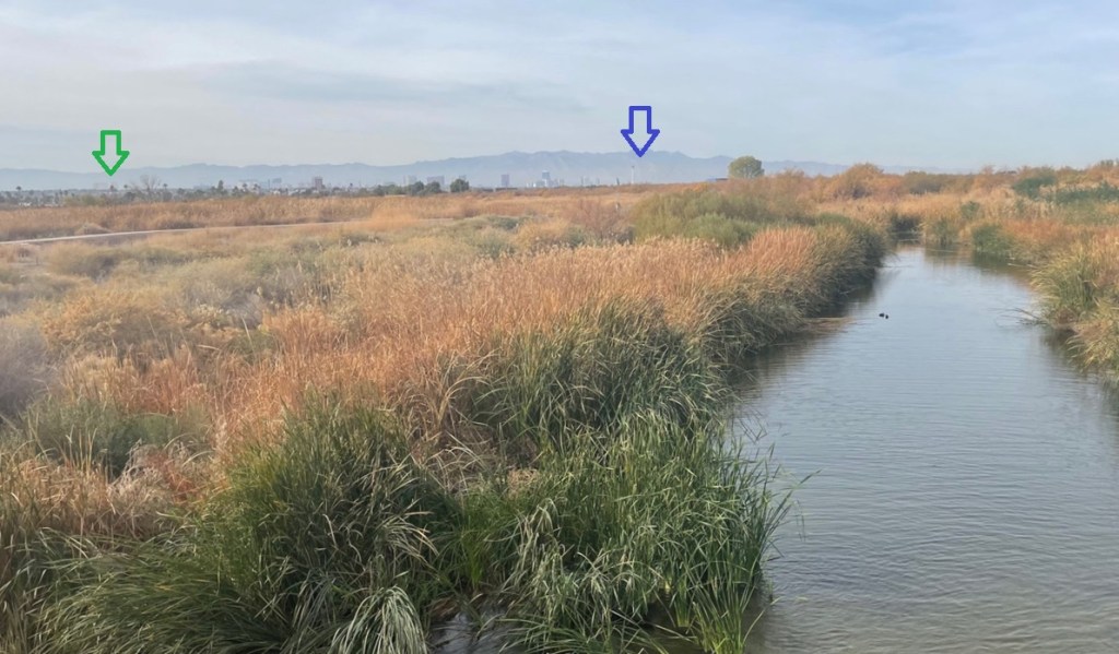
This is a view from the Las Vegas Wash looking west toward Las Vegas Boulevard, or “The Strip.” It was an overcast and hazy day in the Las Vegas Valley, but you can just barely make out some of the structures on The Strip. Mandalay Bay Resort and Casino, the southernmost casino on The Strip and indicated by the green arrow, is about nine miles directly west of this position. The Stratosphere Hotel, Casino and Tower (I think it’s just going by The STRAT now) is indicated by the blue arrow and is located about six miles to the north of Mandalay Bay. (Incidentally, at 1,149 feet the Stratosphere’s observation tower is the tallest in the United States and is second in the Western Hemisphere only to Toronto’s CN Tower at 1,815 feet – but that’s a conversion from metric so who knows what’s really going on?) Anyway, the Spring Mountain Range is on the horizon, and in between Las Vegas Boulevard and the mountains is Red Rock Canyon National Conservation Area, which we visited last winter. Those are American coots swimming in the Las Vegas Wash on the right.We’ve seen lots of little white-crowned sparrows (Zonotrichia leucophrys) since becoming full-time RVers, especially in New Mexico and Arizona, but it’s always a pleasure to see (and hear) them again. Of all the little brown birds (LBBs), they are one of the easiest o identify. Small but mighty, these birds are exceptional migrators and have been tracked flying as many as 300 miles in one night.
Prior to becoming full-time RVers and when we still lived in Denver, Nancy and I visited Las Vegas at least once a year. Like most visitors, we arrived via airplane at Harry Reid International Airport (née McCarran International Airport), and took a cab to our hotel, either on The Strip, or, later and more regularly, in downtown Las Vegas. We’d spend a few fun-filled days, some more profitable than others, and then take a cab back to the airport and return home. A lot of people don’t realize that when they fly into Harry Reid International Airport, spend a few days recreating on The Strip then return to the airport to go back home, they’re not ever actually in Las Vegas – unless they go to the Stratosphere (I don’t care what it’s going by now; I’ll still call it the Stratosphere because I just got used to not calling it Bob Stupak’s Vegas World) or to downtown Las Vegas. Otherwise, each of the roughly 40 hotels and casinos, including places like The Bellagio, Caesar’s Palace, New York New York, The Luxor, The Wynn Las Vegas, and dozens more) along Las Vegas Boulevard, with the exception of the Stratosphere, is in unincorporated Clark County (as is the airport). Those hotels have a total of nearly 89,000 rooms (The Wynn Las Vegas alone has almost 4,800 rooms); compare to, say, downtown Denver which has about 11,000 hotel rooms and the biggest one, the Sheraton Denver Downtown, has 1,231 rooms). The point is, there are a lot of hotel rooms in Las Vegas (and tens of thousands more in unincorporated Clark County), and all of them have bathrooms with showers and flushing toilets, and all of that water needs to go somewhere.
Where it needs to go is into Lake Mead, and how it gets there is via the Las Vegas Wash. Wastewater treatment plant facilities clean up the water as it makes its way to the reservoir; during our visit to the wetlands on December 28, I was reminded of walking and biking on the Cherry Creek Regional Trail in Denver because of the unmistakable (and not entirely unpleasant – certainly more pleasant than it had been before) smell of wastewater under the process of being treated.
Anyhow, and as someone once wrote, back to the birds.
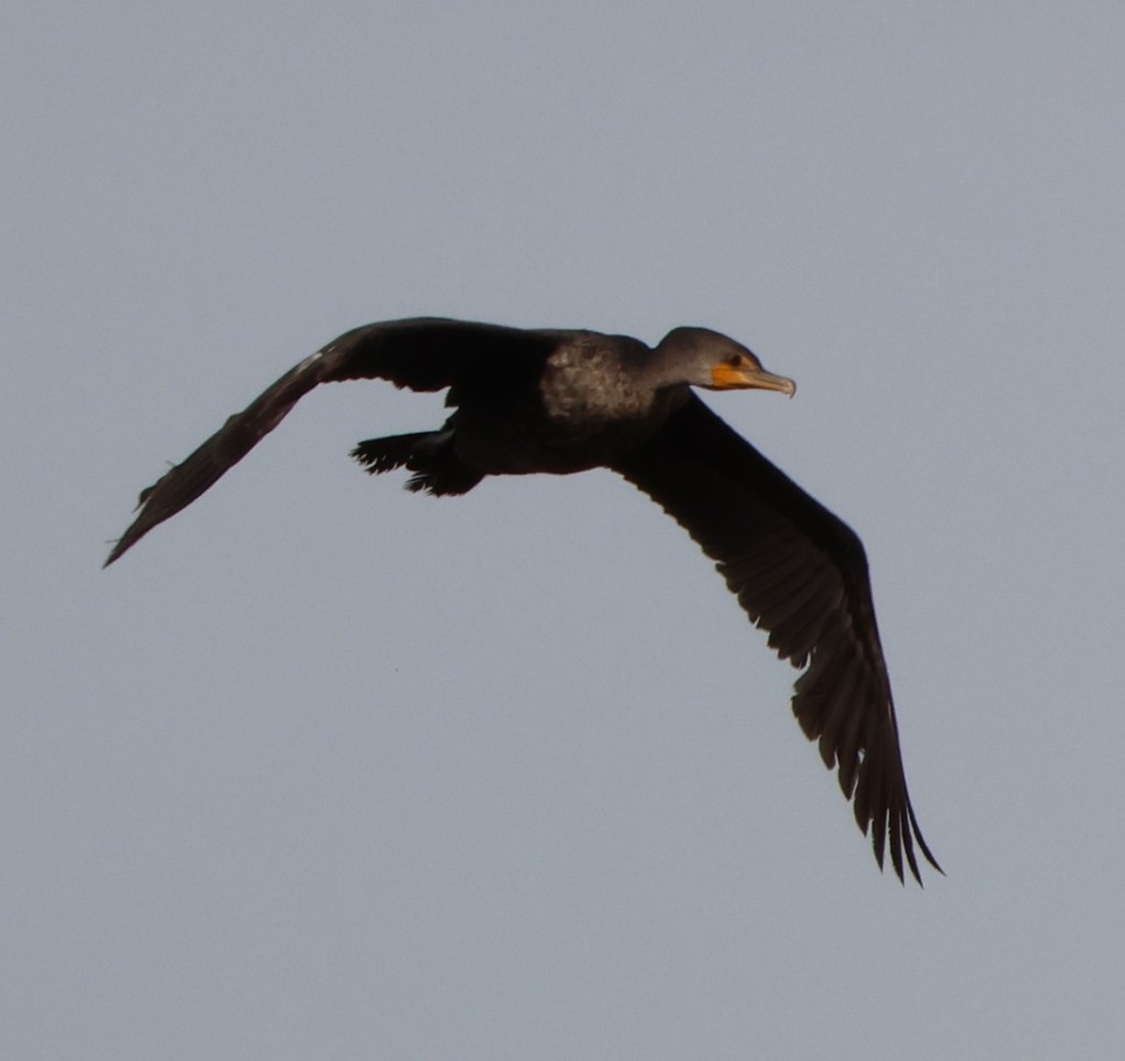
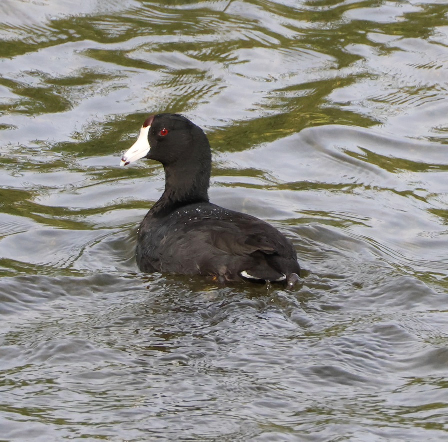
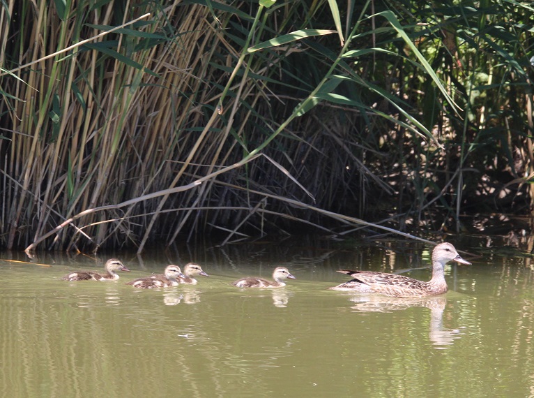
Here’s the first of the never-before-seen-by-us species: the Crissal thrasher (Toxostoma crissale). It’s very similar to a curve-billed thrasher, but the Crissal’s beak is even longer (and more curved, I think). This particular species prefers to stay on the ground, foraging for food, rather than fly about to fill its belly. In the United States, this bird is found only in the southern parts of California, Nevada, Arizona, New Mexico, and far western Texas. I usually avoid editing my pictures, other than cropping and re-sizing, but I decided to adjust the contrast on this one to bring out the bird better. The overcast conditions on the day we visited weren’t the best for photography, and many of the birds were far away (in the nature preserve, where, thanks to Gunther, we weren’t allowed. Thanks again, Gunther.)Happily, the sun happened to be out a bit more when we were on the bridge in Wetlands Park, and I got what I think are some pretty good photos. These ducks were far enough away that I didn’t know what species they were until we got back home and I could have a closer look at the images. This is another new-to-us species, the ring-necked duck (Aythya collaris). As is sometimes the case, the identification feature that’s in the name of this species isn’t really helpful in identifying it: the ring on the neck is very faint, and was probably more visible to early naturalists on captured birds. As a migrator, this species is found throughout North America in different parts of the year; during the fall, Minnesota lakes supporting beds of wild rice can sometimes have flocks of ring-necked ducks numbering in the hundreds of thousands. In this species, as with many other ducks, the male (right) and female (left) genders have remarkably different coloration most of the year (note the extreme difference even in their eye color). As was pointed out to me a few days ago by a full-time resident of this campground, the females of many bird species have to stay more camouflaged to protect the young hatchlings (in that case, we were talking about hummingbirds, but it’s true for many bird species). We’ve had the opportunity to see plenty of double-crested cormorants (Nannopterum auritum), especially at St. Vrain State Park in northern Colorado, but they were usually swimming. For some reason, there were a lot of cormorants on the wing this day at Wetlands Park. This one is showing off its wingspan, which can get to four feet long. Interestingly, despite being a water bird, cormorants do not have waterproof feathers – it’s why they’re often seen on shore with their wings spread. I recently listened to a very interesting audiobook about the Cretaceous-Paleogene Extinction Event, in which an asteroid struck the Earth 66 million years ago and brought the Age of Dinosaurs (mostly) to an end. The author consistently mentioned, though, that only non-avian dinosaurs, or those reptiles that couldn’t take to the air, were made extinct. I’ve mentioned it before, but double-crested cormorants (the white crests appear above the eyes of adult birds only during the breeding season) are one of the best reminders that, in an indirect way, avian dinosaurs still populate the earth.I’ve long been struck by how majestic and powerful most birds look when viewed from the side, or perhaps a three-quarter angle, and how they don’t look at all majestic and powerful when viewed face-on. This is a great blue heron (Ardea herodias), which spent a considerable amount of time among the reeds on the hunt for small fish.The angle makes all the difference: same exact bird. Great blue herons are a lot of fun to watch – they’re very patient while hunting and move almost imperceptibly, but then strike lightning-quick to pull fish from the water. If you look away for a moment, you may have missed all of the action. GBHs grow to a height of almost 4.5 feet and can weigh 5.5 pounds, with wingspans measuring more than 6.5 feet.I originally thought this was a snowy egret (and thus a lifer), but when editing the photo for this posting I realized that its beak is all yellow and its legs are all black (and it’s overall bigger than a snowy egret, which have black beaks and yellow legs). Thus, it’s a great egret (Ardea alba), which we’ve seen plenty of times elsewhere but are still very gratifying to watch. This bird is the symbol of the National Audubon Society, which was created to save this species and others from extinction. Because of their white brilliance, the feathers of great egrets were once valued as decorative accessories for people. This one was just taking off from creekside of the Las Vegas Wash, affording a good view of its feet just above the water. Again, this bird was far enough away while I was photographing it that I wasn’t really sure what species it was, but upon getting home and reviewing it on a bigger screen I discovered that it is an American bittern (Botaurus lentiginosus). This, the third of the “lifer” birds for this walk, was flying about the wash looking for a good place to land. They weigh between 13 and 17 ounces (just over a pound), with a three-foot wingspan. In true Vegas style, we were lucky to see this bittern while on the wing; this species is somewhat rare to observe in the wild because it takes advantage of that striping pattern on its neck and chest to hide motionless among reeds and other tall waterside plants while hunting. American bitterns, also migrators, are found from central and southern Canada down into Mexico at different parts of the year. During the winter months in North America, this species is found only in the extreme southern parts of the southern states and along the eastern and western seaboards. That’s an American coot on the right. We’ve seen American wigeons (Mareca americana) before as well, most memorably near Willcox, Arizona, but it was good to see another one near Las Vegas. We didn’t see any wigeon drakes; only this hen; drakes have a green head and a white crown. Wigeons’ bills are shorter and more goose-like than those of other dabbling ducks, and for that reason more of their diet is plant-based than those of other duck species. That’s an American coot on the right.Compare this egret to the great egret pictured above: notice the black beak and the yellow feet of this one? That’s right: it’s a snowy egret (Egretta thula), and thus the final lifer of the day! Another difference between the two species is their size: great egrets can grow to a height of just over 40 inches and a weight of 35 ounces, while snowy egrets only grow to about 26 inches and a weight of 13 ounces. Regrettably, and although I waited for what seemed like a reasonable time, no American coots made their way into the background of this photo.The “wetlands” aspect of Wetlands Park ends pretty abruptly; in fact, within just a few feet of the water’s edge, the landscape reverts back to extraordinary desolation. The Las Vegas area is in the extreme northeast corner of the Mojave Desert, 54,000 square miles of a dry and sparsely vegetated area that also includes Death Valley. The desert gets between 2 and 6 inches of rain each year, and summertime temperatures regularly climb into the 120-degree-Fahrenheit range. Still, there’s plenty of opportunity for my favorite desert plant, creosote, to grow (although these are, by far, the lowest-growing creosote bushes I’ve ever seen). We’re facing away (east) from the Las Vegas metropolitan area in this view. Yonder, about 20 miles beyond those picnic shelters, lies Lake Mead.Nancy was the first to spot this Say’s phoebe (Sayornis saya) as it flitted about in the shrubbery to our left (well, if Gunther saw it first, he sure didn’t point it out to me). The bird seemed to want to follow us down the trail for a while, giving me plenty of opportunities to snap its picture. These birds are found only in the western United States and Canada, and most of Mexico. They’re actually fairly gregarious, as birds go, and will often roost in buildings. Their diet consists mostly of insects. It’s possible that their name will change sometime in the future: there’s a movement in the birding community to re-name all birds that are named after individuals because it turns out that some of the individuals for whom birds have been named after were not themselves very nice people. Dunno if that’s the case for American naturalist Thomas Say (1787-1834); I do think that individual names are on their way out just for consistency’s sake.The walk that Nancy and Gunther and I were on was a balloon loop, in which you start walking and sooner or later make a left or right turn, then keep walking until you get back to the point at which you made a turn (completing the loop) and then walk back to the start of the hike (completing the “string” of the balloon). This allowed us to make a repeat visit to the bridge under which the Las Vegas Wash ran, and gave us another opportunity to see birds attracted by what the water makes possible – basically, fish and bugs and waterplants. The overcast and hazy conditions of the day were already pretty bad, and the mid-afternoon sun was fading, too, but I did get a few pictures of this belted kingfisher (Megaceryle alcyon) perched over the wash. This photo, too, has been edited to bring out the contrast and colors of the bird. This photo still isn’t that great; the white spot above the kingfisher’s bill is just that: a white spot, and its eyes are black and above and just behind those spots. We’ve seen exactly two belted kingfishers, which is a flying marvel of a waterbird, since we became full-time RVers a little over three years ago. Both of them were seen in Las Vegas, which averages about four inches of rain each year (we saw the other one last winter at another wildlife preserve in Las Vegas proper; I’ll get around to writing about that super-cool place someday). Water really is a crucial aspect of wildlife diversity. We were highly fortunate to see this one actually fishing; it’s an laccomplished flyer and is capable of quickly diving down to the water to catch fish and crawdads with that magnificent bill.We’re nearly to the other end of the bridge now, and running out of water in which to see waterbirds. The ducks to the left, of course, are mallards (Anas platyrhynchos), including the drake at far left and the hen in the middle. Mallards are found all over North America, Europe, and parts of Asia and even Africa. I read recently that domestic ducks (the familiar white ducks of many a barnyard) are domesticated from the mallard species, and the mallard genome is so prevalent in ducks that it’s prone to cross-breeding in wild populations that some species struggle to remain distinct. This lovely couple gives a good size perspective on the snowy egret at right – they’re really not very big, are they?Alright, alright … one more bird before we leave the waterway. This is the fabulous American coot (Fulica americana), which, although it floats like a duck is more closely related to sandhill cranes than anyone in the duck family. I wasn’t going to include this, but there were (obviously) about three kajillion coots on the Las Vegas Wash that day and it doesn’t seem right to exclude an exclusive photo. This is, incidentally, the best picture of a coot I’ve ever taken; their black color and tendency to hide amongst water plants makes them difficult to photograph well. This was probably the biggest bird we saw during our walk. It’s hard for me to resist taking pictures of aircraft flying overhead, even while enjoying the serenity of nature. This is a Boeing 737 Max 8, registration number N17341 and operating as United Airlines Flight 1981, shortly after its scheduled departure from LAS (Harry Reid International Airport) at 2:05 PM Pacific time, with scheduled arrival at EWR (Newark Liberty International Airport in New Jersey) at 9:59 PM Eastern time. N17341 saw a lot of the country on December 28: it left Charleston International Airport (CHS) in South Carolina at 6:00 AM Eastern, flying first to EWR, then flew cross-country to LAS, then had this flight back to EWR. More than 1,050 flights arrive at and depart from LAS every day; it’s the country’s eighth-busiest airport.
The next couple of photos aren’t from the Las Vegas Wetlands Park walk – they’re ones I took in our campground in which we’ve been staying the winter. There’s not necessarily a lot of variety of birds here, but they’re still fun to keep an eye out for.
I often see this little dude, a male Anna’s hummingbird (Calypte anna), when Gunther and I are visiting our campground’s dog park in the mornings. While Gunther is attending to his business, I look to this same little branch on this same little tree, and about half the time he’s there, just about 10 yards from the dog park’s fence. The legs of all hummingbirds are so small that the birds can neither walk nor hop on the ground or on a branch. They, like all hummingbirds, are tiny: Anna’s have all the volume of a ping-pong ball and the all the mass of a shiny U.S. nickel (between a tenth and two-tenths of an ounce). As small as they are, they’re powerful fliers: males can soar up to 130 feet in the air. This species of hummingbird, one of 360 in the world, is found year-round in the Las Vegas area, as well as the western halves of California, Oregon, and Washington. Say, that reminds me: I’ve recently learned the German word for “pineapple” is “Ananas,” so the imperativ (command) for “Anna, eat pineapple!” in German is “Anna, esse Ananas!”Here’s another reminder that we share this planet with dinosaurs’ descendants: imagine the slashing terror of these razor-sharp talons, the brute strength of these powerful claws, the raw crushing horror of …… a rock pigeon (Columba livia), which is found year-round all over North, Central, and South America, and the campground in which we are spending the winter.Gunther thanks you for joining him (and Nancy and me) on this Las Vegas Wash adventure, and hopes you have a healthy and happy 2025 filled with lots of fun walks!
Here’s a list of the birds (not all are pictured above) we saw at Wetlands Park; it was one of the more successful birding walks we’ve ever enjoyed, and just a fun way to spend an afternoon in The Entertainment Capital of the World.
I’ve been reading “Riders of the Purple Sage,” one of Zane Grey’s early books that helped shape the Western novel formula. Publishing the book in 1918, Grey (1872-1930) was inspired to write a Western story after reading Owen Wister’s “The Virginian” (1902). It would be the most popular of Grey’s 90 books (it’s estimated that he wrote 9 million words in his career). Later prolific western authors like Max Brand and Louis L’Amour were heavily influenced by Grey; L’Amour himself wrote 89 novels and 14 collections of short stories. “Riders of the Purple Sage” has been adapted for film five times: in 1918 and `1925 (both were silent movies), 1931, 1941, and a 1996 TV movie starring Ed Harris and Amy Madigan (who have been married to each other since 1983).
Although I’ve read “The Virginian” and lots of Louis L’Amour’s books, I’ve never read a Zane Grey novel (my only point of reference to Grey was knowing that Colonel Sherman Potter of the 4077th Mobile Army Surgical Hospital was a big fan). I’ve been struck how, in “Riders of the Purple Sage,” Grey deftly describes the canyons, mesas, and flatlands of southern Utah, the setting of the book. The characterization and dialog in the book are definitely of their time, but the story itself is pretty exciting and Grey was quite skilled at painting, in words, how the incredible scenery of the region appears.
Reading “Riders of the Purple Sage” reminded me of when we were in southern Utah and northern Arizona for an extended visit in 2023. We’d planned to stay in Fredonia, Arizona, for four weeks so that we could visit a couple of national parks and monuments in the region. Mechanical issues with The Goddard, our fifth-wheel trailer, extended our stay for an additional week. We were unable to lower the front jacks of our trailer, which meant that it had to stay hitched to the six-wheeled towing unit. A very competent RV technician was able to help us manually lower the jacks and we were able to unhitch our F-350, and he later fixed the jack-lowering issue (turns out a rodent probably chewed through a wire while we were camping at the south rim of the Grand Canyon; lesson learned is to never go to the Grand Canyon again). At any rate, our extended stay while waiting for RV parts was a fortunate one as we were able to visit the north rim of the Grand Canyon, which, due to snow, didn’t open until early June that year.
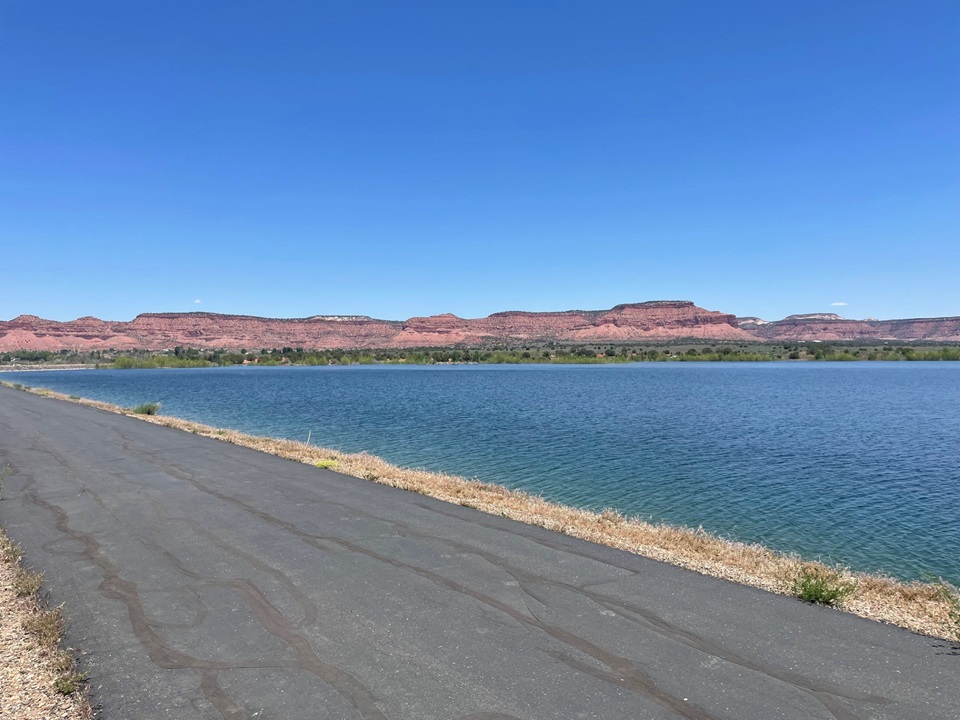
This post, however, is not about either rim of the Grand Canyon but rather a manmade lake in Utah. Our campground was in Fredonia, Arizona, about four miles south of the Arizona/Utah border. We spent quite a bit of time in Kanab, Utah (itself about four miles north of the border), partly because we found a reservoir near Kanab that offered great hiking and birding opportunities. We visited the lake three times in late May and early June, and this post has pictures from all of those excursions. We saw lots of different species of birds, and we were fortunate to have timed our visit for some pretty impressive displays of blossoming plants.
The average depth of Jackson Flat Reservoir is only 28 feet. It’s primarily a holding reservoir for irrigation water, but the lake receives plenty of non-motorized boating, hiking, swimming, fishing, and stargazing enthusiasts. The sage in this photo isn’t purple like in the Zane Grey book, but maybe it’s due to the time of day that I took the picture.
Jackson Flat Reservoir, located between Kanab and the state line, had been in its planning stages for nearly two decades when construction began in 2010. The reservoir meets local agricultural irrigation needs, and is also a wonderful boating, swimming, and hiking destination for Kanab residents. Built to a capacity of 4,228 acre-feet, the reservoir attracts a large number of waterfowl and other birds to southeast Utah.
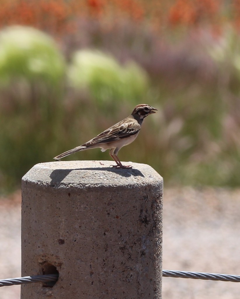
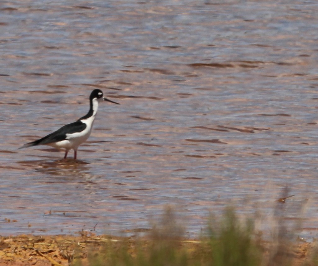
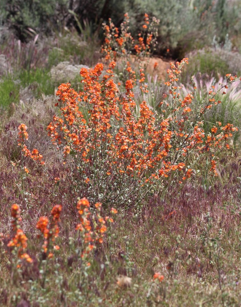
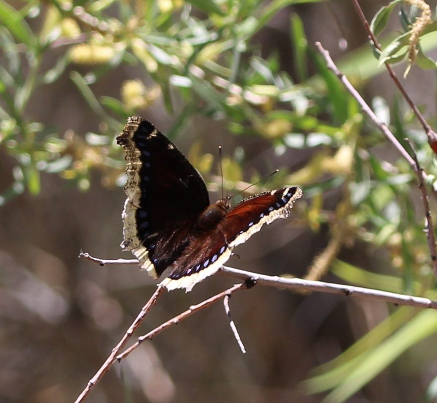
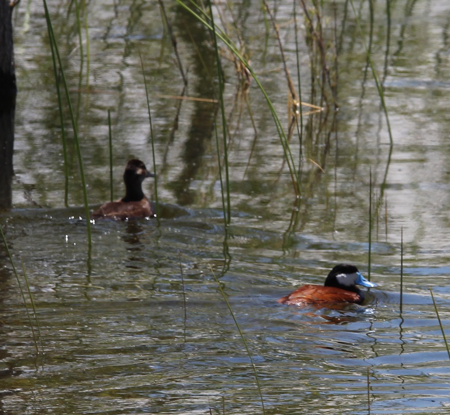
Birds with predominantly black coloration are frustratingly difficult to photograph unless the lighting is just right; I really like the pattern on this common loon (Chondestes grammacus) so I decided to include the picture in this posting. Nancy and I watched this bird for quite some time; it would disappear under the water for up to a minute at a time, and it was kind of fun to guess where he’d pop back up. Their diet consists mostly of crustaceans and small fish. Common loons are found all over the United States – it’s likely how they got their name.Writing of “common,” here’s a common raven (Corvus corax) behind a juniper bush, looking much like a Muppet. True to their name, these birds are the most common of corvids (a family of birds that also includes crows, magpies, and jays), and, weighing in at 3.2 pounds at maturity, they are the largest of the passerine order (basically birds that perch, about half of the species on the planet). On our walks around the lake, we saw several ravens being chased in the air by red-winged blackbirds that were presumably defending their nests.Writing of which, here’s a red-winged blackbird (Agelaius phoeniceus) patrolling water’s edge. “But Ken,” you might think to yourself, “this bird is neither red-winged nor black.” I would agree with you, and likely add that it looks like one of the 70 million species of brown-colored sparrows. This is, however, a female red-winged blackbird, which do not have the black color and red wing markings of the males of the species. You can differentiate a female red-winged blackbird from a sparrow by looking at the beak: it’s much more pointed and angular than say, …… the beak of this brown-colored sparrow. This is a lark sparrow (Chondestes grammacus), a species we seemingly see sparingly, but is actually fairly common and distributed throughout most of the United States and Mexico. To remind us that we were in an arid desert environment, there were several varieties of cactus growing around the reservoir. This is tulip prickly pear (Opuntia phaeacantha) featuring riotously vibrant colors on its blossoms. Whenever I see bright colors like this on flowers, or a bird, or a tropical fish, I think, “There’s a color not found in nature.” But they are literally found in nature. This is the road over the dam of Jackson Flat Reservoir, with the cliffs of southern Utah in the distance. The Grand Staircase-Escalante National Monument’s western border is just to the right edge of this photograph. The reservoir’s dam contains 800,000 yards of dirt and rocks. One thing I like to do when seeing a reservoir’s dam is to cry out “Dam!” I wonder if Nancy ever gets tired of me doing that. I should probably ask her sometime. We see a lot of dams.Some of the waterfowl we saw were far away from the trail that goes around the reservoir. This was a new species to us, so I decided to include it even though it’s a terrible photo. This is a black-necked stilt (Chondestes grammacus). It’s found in the western United States and down into Mexico, and in quite a bit of South America as well. They are about 15 inches tall, with long pink legs and a wingspan of close to 30 inches. Like other shorebirds, black-necked stilts use their long bills and beaks to feed on freshwater shrimp, as well as crayfish and small fish. Species like these have no business being in the arid desert of southern Utah, except for the existence of Jackson Flat Reservoir – it’s a great benefit to area residents to be able to see birds like this.Indian paintbrush has long been one of my favorite wildflowers. There are more than 200 species of this plant; I’m pretty sure this is Wyoming Indian paintbrush (Castilleja linariifolia), which is the state flower of … Wyoming.THIS IS A TALES OF THE GODDARD LIZARD ALERT. Movement at the side of the trail around the reservoir attracted our attention to this western fence lizard, a very common reptile in the western United States. Note the blue patch on his throat; that blue shading also extends to his stomach (I’m guessing; I didn’t pick this rascal up to check) and leads to another name for the lizard: the bluebelly. There are five subspecies of western fence lizards; they have a SVL (snout-vent length) of 2.25 to 3.5 inches.As I wrote earlier, we happened to time our visits to Jackson Flat Reservoir when many flowering plants were blossoming. The flowering of this plant, desert globemallow (Sphaeralcea ambigua), lasted throughout our entire stay in the region: it was everywhere. It generally grows to a height of three feet, and is host to the caterpillar stage of a number of butterfly and moth species.Writing of which, here’s a butterfly species called the mourning cloak (Nymphalis antiopa). This butterfly is found in both North America and Europe. Because it feeds on sap from trees and shrubs, it’s not a significant pollinator.Back to birds: here is a couple of double-crested cormorants (Nannopterum auritum), contemplating a cooling dip in the waters of Jackson Flat Reservoir. Although they are definitely water birds, their feathers are not waterproof and they are often seen standing on the shore with their wings spread out in order to dry off. Their diet is exclusively fish-based.One of the facets of birding that I really like is the opportunity to see pairs of a particular species. The males and females of many species are often seen close together, and you get the opportunity to see how the two genders differ in appearance. This is a pair of ruddy ducks (Oxyura jamaicensis), easily identified by the male’s bright blue bill which only appears that way during the summer months (it’s gray the rest of the year).There are a number of really distinctive-looking birds of which I’d only seen pictures or video footage of, but never in real life until Nancy and I started full-time RVing. I’ll never forget seeing a wood duck in real life for the first time (at a state park in Albuquerque, New Mexico), or a scarlet tanager (at a campground in Tucson, Arizona), a common loon (on a lake in western Michigan), a northern cardinal (at a campground in Oklahoma) or a greater roadrunner (at a campground in Albuquerque). I’ve now seen all of those species several times in the last three years, but it’s always a thrill to see them again. The Gambel’s quail (Callipepla gambelii) is another of those birds: I first saw them at a regional park outside of Phoenix, Arizona, and I’ve seen them many times since then, but it’s still really fun to encounter them because of their distinctive appearance. This species is native to the American Southwest, and is also found in parts of Colorado and Texas.Gunther found this lovely stand of desert mallow on a walk near our campground in Fredonia. During our stay in northern Arizona, we saw about 50 kajillion of these flowers; at times, the landscape looked like a sea of pink-orange coral. But “Riders of the Pink-Orange Desert Mallow” doesn’t really have the right zing, and Zane Grey was probably right to title his novel the way he did.
A little more than 66 million years ago, a metallic asteroid the size of Mount Everest slammed into what is today the upper Yucatan Peninsula in Mexico and things really haven’t been the same since.
For one, the impact directly or indirectly caused the extinction of three-quarters of all organic life on Earth, including all of the dinosaur species that couldn’t fly. A dust cloud from the impact entered the planet’s atmosphere and blocked the Sun for months, preventing photosynthesis in plants, causing catastrophic climate change, and immediately or eventually killing any terrestrial animal weighing more than 55 pounds, except for some cold-blooded amphibious species such as sea turtles and crocodiles. The impact also caused tsunamis to crash against the coastal areas of the planet, and, because the asteroid crashed into a bed of gypsum, immense quantities of sulfur trioxide were thrust into the atmosphere to later fall as acid rain for days.
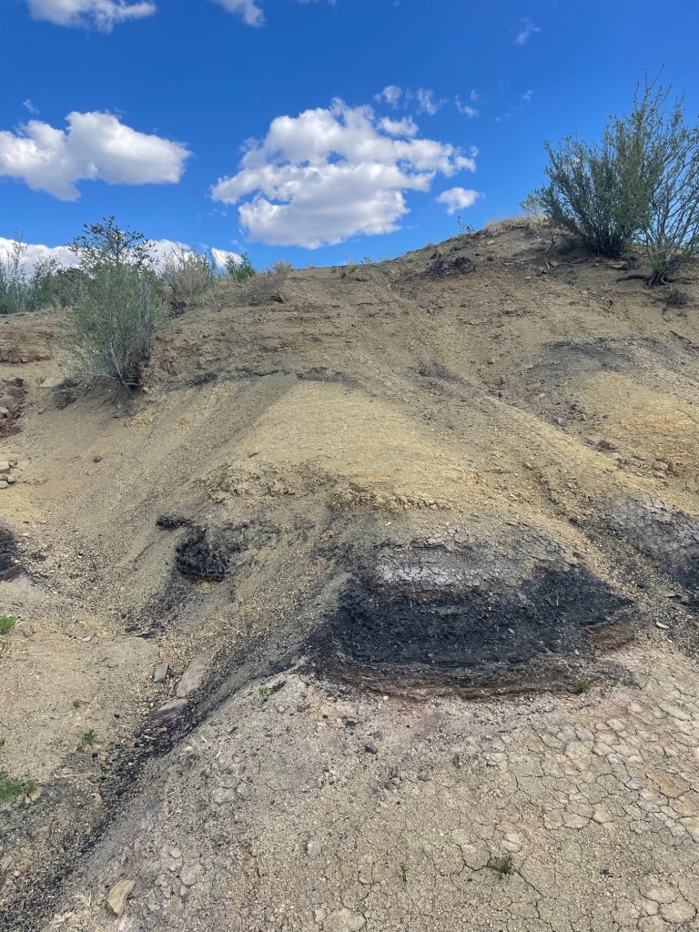
The Santa Fe Trail, a major trade, military, and settlement route connecting Kansas City, Missouri, and Santa Fe, New Mexico, cut through the middle of what is now Raton, New Mexico. The area had a post office called Willow Springs from 1877 to 1879, then it was changed to Otero for a couple of years before being renamed Raton in 1880. The city became a center for the railroad, mining, and ranching industries in northeastern New Mexico. This is looking southeast from the hilltop on which the iridium layer is located. All of the mountains on the horizon are extinct volcanoes that arose and erupted many millions of years after the end of the Cretaceous Period.
In short, Earth was a place best avoided for the near- and medium term following the planet’s encounter with an asteroid. In addition to being much colder because of the dust cloud blocking the sun, the lack of plant life due to the cessation of photosynthesis doomed herbivorous dinosaurs like triceratops and titanosaurs, and later the carnivorous genera, like abelisaurids and tyrannosaurids, that preyed upon them.
A lone hiker (it’s Nancy) stands a silent vigil near the K-Pg boundary. The city of Raton has placed this helpful sign to assist in identifying the inch-thick layer of clay containing high concentrations of the element iridium. The layer is sandwiched between sandstone dating back to the Cretaceous Period, when dinosaurs ruled the Earth, and sandstone and coal from the Paleogenic Period, when mammalian species began to flourish.
Things are better today, of course (with the exception that there are no more Tyrannosaurus rexes running around, and even that’s probably for the best). The impact had a huge influence on how life on the planet, including the eventual species of H. sapiens, was able to emerge and evolve.
When I was a kid, an asteroid crashing into the Earth was only one of several hypothesized reasons for the disappearance of the dinosaurs. The existence of a particular layer of sediment, originally discovered in Italy but since found around the world, was a major factor in the popularity of that hypothesis: dinosaur fossils, footprints, and other artifacts could be found below this layer, but not above. That particular layer of sediment, which has since been found in many locations around the globe, is unique in that it contains as much as 160 times more of the element iridium than other layers of the Earth’s crust. Iridium (atomic symbol Ir and atomic number 77) is a metallic element found commonly on asteroids flitting about the cosmos, but it’s not found naturally occurring on Earth except when one of those asteroids flits into the planet.
However, until the actual crater for the possible asteroid impact 66 million years ago was discovered, the theory remained only one of the possibilities for what is now called the Cretaceous-Paleogene (K-Pg) extinction event (again, when I was young the K-Pg event was called the Cretaceous-Tertiary, or K-T, event; the “K” is used instead of “C” for Cretaceous because the German word for “chalk,” from which the Latinate “Cretaceous” is derived, is “Kreide”). Some scientists believed that the layer, and the mass extinction event that it documented, could have been caused by the explosion of a relatively nearby supernova, or by gradual climate change, or by a reversal of the planet’s geomagnetic poles (you can understand how magnetic north becoming magnetic south, and vice versa, would be undesirable).
In the early 1980s, a crater more than 90 miles in diameter (about the combined area of Massachusetts, Connecticut, and Rhode Island) and between 6 and 12 miles deep was discovered near the town of Chicxulub (pr. “cheek-shoe-LOOB”) on the Yucatan Peninsula, and chemical and geologic analysis of the impact site showed that scientists finally had their hole in the ground proving that the age of the dinosaurs was ended by an asteroid collision. Researchers believe the Chicxulub asteroid was probably about six miles wide – tiny compared to the Earth, but it was hurtling along at about 12 miles per second so it was ready to do some damage.
Incidentally, I read an interesting book several years ago about past extinction events on Earth, one of which was the Chicxulub impact, and the book’s author wrote that the explosive nature of the asteroid collision was so violent that vaporized bits of organic matter on the planet’s surface could have been ejected into space. The author asked a researcher if it’s possible that there are tiny bits of dinosaurs on the Moon, and the researcher said that yes, it is possible that there are tiny bits of dinosaurs on the Moon.
But I digress. Life on Earth was drastically changed after the asteroid impact, and, with the exception of smaller flying lizards that could more easily find food and shelter (and which would evolve into our feathered friends of today), the dinosaurs were no more – and an age in which mammals could diversify and grow in species number had begun.
Despite the signage, it’s a little difficult for laypersons like ourselves to positively identify the exact layer containing iridium. However, we believe it to be the one-inch-thick layer of light-colored clay material directly above the very dark layer of rocks pictured in the center of this photo (if any experts happening to read this posting dispute this, I’ll happily correct this information). The iridium layer contains, in addition to large quantities of the titular element, shocked quartz and other materials indicative of an asteroid strike. All of the material under that layer is at least 66 million years old; everything above it was deposited after the age of the dinosaurs.
Because iridium exists on the planet only because of asteroid collisions, it’s one of the least-common elements on Earth – it’s four times as rare as gold. Iridium is one of the densest metals on the planet: a cubic inch of iridium weighs just over three-quarters of a pound (12.96 ounces, to be precise). Only one element, osmium, is more dense than iridium and it’s just barely so; osmium (Os) and iridium are both twice as heavy as lead (Pb, which has that symbol because of its Latin name, plumbum). Iridium’s resistance to heat and corrosion lends itself to uses in metallurgy (such as crucibles for less-dense metals) and electronics.
Many years ago, the steel nibs of fountain pens were tipped with alloys containing iridium in order to take advantage of the element’s hardness and resistance to corrosion. Most nibs then, as now, were made from steel. Over time, constant usage of the pen would wear down even the steel of a nib – so manufacturers tipped the nibs with harder metals like iridium to prolong their usage. However, iridium has become so difficult and expensive to source (and, given where the element comes from, we really don’t want more iridium on the planet anytime soon) that fountain pen nib manufacturers now use alloys of ruthenium, osmium, and tungsten (but sometimes, confusingly, call those alloys “iridium”). This is a 10x magnification of one of my fountain pens, a Pilot Custom 823. The nib itself is made of 14k gold for flexibility while writing, but the tipping, or the somewhat rounded extreme end of the pen, is made of harder alloys.
The K-Pg layer was first discovered in Italy but since then many other outcroppings of the iridium layer have been found around the world. One of those occurrences is near the small town of Raton, New Mexico (pop. 6,000), where we camped in the Goddard in the spring of 2024. Raton (Spanish for “mouse”) is about six miles south of the New Mexico-Colorado border in the far northeastern corner of the Land of Enchantment.
Nancy and I visited the site of the iridium layer late one afternoon in early May. I’d secured a permit to visit the site the day before at Raton’s municipal office. It turned out we didn’t really need a permit because it simply supplied the combination to a locked gate on the road and permission to park at the iridium layer site, and we didn’t think that there’d be room for the Goddard’s six-wheeled and 22-feet-long towing unit. We instead parked the towing unit downhill from the iridium layer site and hiked past the gate and then a mile or so to the site itself (the walk the day before from our campsite to the municipal office to acquire the permit, which we didn’t need, and back was 5.5 miles). Both were lovely walks (I saw a small group of mule deer in the front yard of a house in Raton on the way back to our campsite).
It further turned out that we could have driven the towing unit to the site, as there was plenty of room to park and turn around. But, as I mentioned, they were lovely walks.
We didn’t see much in the way of wildlife on our visit to the iridium layer, but we did encounter several of these rock wrens (Salpinctes obsoletus) on our walk back to the Goddard’s six-wheeled towing unit. These little birds weigh only about half an ounce, with a wingspan of 9 inches. Northern New Mexico is at the very northern edge of their year-round residency area; they are migratory into southwestern Canada.Since this posting is sort of about dinosaurs, I’ll include a couple more photos of the dinosaurs’ descendants that I took at our campground in Raton. This is a chipping sparrow (Spizella passerina), of which we saw many in Raton. There are two major groups of chipping sparrows in North America, eastern and western, and each of those groups have different varieties. As someone who struggles with sparrow species identification, I appreciate the chipping sparrow’s distinctive lil’ red cap.There were also plenty of common ravens (Corvus corax) in the campground and Raton. These are large birds – measuring up to 25 inches long, weighing 3.2 pounds, and boasting a wingspan of up to 5 feet – and they are remarkably long-lived as well: more than 23 years in the wild. Many people have trouble differentiating ravens from their smaller cousins, American crows, but ravens are on the whole larger, with wedge-shaped tails and much larger beaks in proportion to their heads. Like many other corvids, ravens are noted for their problem-solving abilities.
The few dinosaurs that survived the Chicxulub impact are the ones that were able to take to the skies, and their evolutionary descendants include rock wrens, chipping sparrows, and common ravens, as well as American white pelicans, common ostriches, Anna’s hummingbirds, emperor penguins, and others that comprise the 11,000 species of birds with which we share this planet.
One might wonder about why a one-inch layer of dirt that’s found around the world is important. I think it’s instructive to consider what life on Earth would be like had the planet not been pummeled by an asteroid 66 million years ago. Dinosaurs were the dominant lifeforms on Earth for around 175 million years, from their first appearance during the Triassic Period about 240 million years ago to being (mostly) destroyed by the Chicxulub asteroid. That’s an awfully long time to dominate; in fact, our existence as humankind is closer to the time that Tyrannosaurs were alive than the time between the Stegosaurus genus and Tyrannosaur genus were both alive; the former was even fossilized by the time T. rex had evolved. It’s very possible that gigantic, ground-shaking, and ferocious (and small-brained) lizards could still be the most dominant animals on the planet, and that mammals, although they’d first appeared on Earth well before the Chicxulub asteroid collision, would never have had the opportunity to gain a strong foothold with which to start their evolutionary path.
In short, you can probably thank the Chicxulub asteroid for you being here today. Also, it wouldn’t hurt to hope that a similar impact doesn’t occur anytime soon.
El Malpais (pr. el-mal-pie-EES) National Monument, located near the town of Grants in northwestern New Mexico, showcases a number of different geological features in its nearly 180 square miles – but it’s best known for its impressive lava flows dating from 60,000 to only 4,000 years ago.
While Native Americans have lived in the El Malpais area for 12,000 years, early 17th-century Spanish explorers coming north from Mexico found the region nearly impassable by their horse-drawn wagons and carts. Those explorers gave the region its name, which means “the bad land” in Spanish and refers to the rocky topography left behind by the extensive lava flows.
El Malpais National Monument was established on Dec. 31, 1987, and about 100,000 people visit it each year.
We camped for a week in Grants and visited several different features of the national monument. The highlight, however, was a great hike that took us to the top of a cinder cone from which much of the monument’s lava had flowed.
The El Calderon Trail is located on the western side of the national monument – it happened to be only a 20-mile drive from Grants. We’re still trying to adjust to being on trails that aren’t in Colorado: there were two other vehicles in the trailhead’s parking lot when we arrived at 10 AM, and in the entire course of the 5-mile loop hike, we saw nearly as many dogs (two) as we did people (three).
This iGoogle Maps satellite image, in which a quarter-inch represents two miles, shows nearly the entirety of El Malpais National Monument. The monument’s visitor center fs indicated at the top, and just to the left is the town of Grants, New Mexico, where we parked the Goddard for a week in April 2024. Grants is on Interstate 40 about halfway between the Arizona/New Mexico state line and the city of Albuquerque, New Mexico. Everything represented in dark greenish-black in the lower two-thirds of the image is basalt, or lava rock; the greenish hue is provided by plant life amongst the basalt. The town of Grants, too, is surrounded by basalt.
Shortly after the trailhead, the El Calderon trail passes by several caves that are actually lava tubes and are now home to bat populations. Lava tubes are formed when flowing lava exits an existing lava vent covered with a roof of lava rock, leaving behind a cave-like structure.
Here we see a brave hiker (it’s Nancy) at the entrance to Bat Cave in the national monument. This lava tube is a summer home for thousands of Mexican free-tailed bats that emerge at night to hunt for insects. There is still evidence of a guano mining operation in Bat Cave; bat droppings are high in nitrates and therefore valuable as fertilizer. We learned at Mammoth Cave National Park in Kentucky that guano was also once used in the production of gunpowder. To protect the flying mammal population, Bat Cave in El Malpais National Monument is closed to human visitors.Much of the El Calderon trail looks like this: relatively flat, with expansive views, through a moderately wooded forest with several different species of pine trees and evergreen shrubs.There weren’t many wildflowers in bloom when we hiked the El Calderon Trail on April 20, but we’d just missed the blossoms of the tree cholla (Cylindropuntia imbricata). Also known as cane cholla, this cactus typically grows to a height of 3 feet, but can reach 15 feet. The flowers are a very bright magenta color, and the yellow fruits, shaped roughly like a pinecone, can last on the plant for a long time. They apparently don’t taste great, but the Native Americans of present-day Arizona and New Mexico did use them as a food source.This is a TALES OF THE GODDARD LIZARD ALERT. I’d walked by this pair of horned lizards on the lava rocks lining the trail without seeing them but they didn’t escape the notice of Gunther, who Nancy had on a leash behind me. I was able to get several photos of them before we moved on down the trail. Their camouflage really is amazing – if they hadn’t moved as I passed by, Nancy said Gunther probably wouldn’t have seen them either.This is a close-up of the lizard in the background of the above photo. There are 21 species of horned lizards in the world, 15 of which are native to the United States. Five of them reside in El Malpais National Monument, and, without being familiar with any of them, I’ll just say this is one of those five species (although based on the coloration and locality I’m leaning toward a greater short-horned lizard, or Phrynosoma hernandesi). Horned lizards are often called horned toads, but they’re not toads or even amphibians at all: they are reptiles. It’s somehow reassuring to know that dinosaurs still walk among us, however small they may be. Females of the short-horned lizard species grow to about 7 centimeters (2.75 inches) SVL, while males grow to only 5 centimeters SVL. What’s SVL, you ask? I had to look it up as well: it’s an abbreviation for a herpetology term called snout-vent length (basically the length of the lizard not including the tail).The entire trail was lined with readily available lava rocks, which made for interesting viewing while hiking because of all of the different textures. Each was different, but the trailbuilders used rocks that were roughly a foot in height and width. One can only imagine the scene 115,000 years ago, when these rocks were being created: what did it look like, sound like, and smell like?We’ve seen plenty of lava tubes in Hawaii, Idaho, and now New Mexico, but I don’t think we’ve ever seen a distinct lava trench. They are formed in the same way as lava tubes, but the roof of the tube collapses soon after the lava of the tube cools. Water collects in the bottom of these trenches, allowing trees and other foliage to grow larger than their counterparts outside the trench.This is the side of the El Calderon cinder cone, from which rivers of magma flowed about 60,000 years ago to create immense rivers of lava that found their way 20 miles north to the present-day town of Grants. A cinder cone is formed when gravel-sized bits of lava are shot hundreds of feet into the air from a volcanic vent in the ground. The billions of tiny cinders fall back to earth and eventually form a cone-like structure; El Calderon is 300 feet high. The two different colors of cinders – red and black – indicate different mineral composition and different eruption periods. The trail includes an optional loop around the top of the cinder cone — it was a 300 foot gain in elevation, but the views were well worth the effort.This is a view looking northeast from the top of the El Calderon cinder cone (the side of the cinder cone pictured above is directly below this position). The red cinders contain high levels of oxidized iron: essentially, rust. On the far left of the photo one can just barely make out the snow-covered top of Mount Taylor (elev. 11,305 feet), about 30 miles away on the other side of the nearer hills. Mount Taylor is an extinct volcano that last erupted about 1.5 million years ago – long before the volcanic activity on El Malpais National Monument occurred. It is a mountain sacred to a number of Native American pueblos, including the Acoma, Zuni, Hopi, Laguna, and Navajo.This is a view looking down into the interior of El Calderon, fairly close to where the previous photo was taken but in the opposite direction. It’s a peaceful basin filled with pine trees and grasses now, but it was the source of all of those lava cinders shooting upwards into the sky when the volcano was active 60,000 years ago. El Calderon translates to “the cauldron” in Spanish.Time for lunch – trailside! We heard, but could not see, a couple of different birds singing in some nearby pines during our lunch. Afterwards, I got a couple of pictures of them. The pictures didn’t turn out well at all (they were still far away and the skies were overcast), but it turns out that they were gray flycatchers (Empidonax wrightii), and, judging by the grass in their beaks, they were building a nest.We saw these white growths on nearly every rubber rabbitbrush (Ericameria nauseosa) plant we saw on the hike. Nancy asked what they were and I replied that they were spider egg cases, each just waiting to pop with up to 100 individual spiderlings. She refused to believe me, which was probably the right thing to do, but it meant that I later had to look up what they really are. It turns out my wild guess wasn’t very far from the truth: they’re called galls, and they are home to larvae of a fruit fly. The galls, produced by the plant’s reaction to irritating chemicals introduced by the parasitic insect, act as both a home and a food source for the larvae. They don’t appear to harm the rabbitbrush plant at all.It’s a little difficult to make out in this picture, but there’s a tree species we weren’t expecting to see in northern New Mesico on the other side of the fallen log, just left of center. It’s an aspen tree, which is made possible by what the scientists call “the edge effect,” or additional moisture that collects along the area where lava fields meet conventional landscapes. The edge effect allows plants that need additional moisture, like aspens, to thrive in otherwise harsh environments.I thought the smooth side of this hunk of basalt was interesting: it indicates that the lava was moving fairly quickly as it cooled. Lava fields, after they cool and begin to erode, make for fairly good habitat for plants: the basaltic rocks hold a lot of water and trap a good variety of airborne seeds.The skies above us unfortunately still chose to be overcast when we saw this western bluebird (Sialia mexicana) perched on an oft-used branch, but the bird’s bright colors still impressed us. Western bluebirds are members of the thrush family, and their diet consists of worms and berries found on the ground as well as insects plucked from the air.The trail on the right side of this photo is the 2,700-mile-long Continental Divide Trail, which meets and shares some distance with the El Calderon Trail. If one were to follow that path, one would wind up at the Canadian border with Montana. We elected to continue on our loop to the El Calderon trailhead instead.
The hike to El Calderon was one of the more rewarding trails Nancy and I have been on in a long time: fantastic views, lots of fascinating geologic features, a good variety of plants, and a bit of wildlife to observe.
There is a lot of geology to appreciate about El Malpais National Monument, and not all of it has to do with lava. On a weekday evening, Gunther and Nancy and I drove to the east side of the monument to see two sandstone features: La Ventana and a sandstone bluffs overlook.
About 160 million years ago, the El Malpais area looked a lot like today’s Sahara Desert: covered with hundreds of feet of sand that, compressed by other layers of sediment, eventually formed sandstone. This arch, formed by the weathering effects of freezing and thawing water trapped in the sediment over millions of years, is 135 feet across and only 25 feet wide at its thinnest point. Spanish explorers called this arch “La Ventana,” or “the window.” It is one of the largest natural stone arches in the state of New Mexico.This is a sandstone bluff overlook that provides great views of the basaltic lava flows hundreds of feet below. More than 200 volcanic vents have been identified in the national monument, and this sandstone is tens of millions of years older than any of them.
Nancy and I both have more than a passing interest in geology, and especially volcanoes, so El Malpais National Monument was a great place to spend a week. We spent the summer of 2023 surrounded by volcanic features in Idaho, and it was fun to once again be amongst these reminders in New Mexico that our planet continues to reshape itself all the time.
Grand Staircase-Escalante National Monument is big – really big. In fact, although it’s the seventh-largest U.S. national monument by size, it’s the biggest in the country that’s not either entirely in or adjacent to an ocean. At 1.87 million acres (just over 2,900 square miles), the national monument is nearly twice as big as the entire state of Rhode Island, and just a tad bigger than the state of Delaware.
This area in southern Utah is vast, and it is remote: it was the last part of the contiguous United States to be mapped by the federal government. Grand Staircase-Escalante National Monument was authorized by President Bill Clinton in 1996. This is also one of the more contentious federal properties; President Donald Trump effectively halved its acreage in 2017, and then President Joe Biden restored it to its current size in 2021. It is the first national monument to be administered solely by the Bureau of Land Management (BLM).
(A brief sidenote: the U.S. government’s holding of lands, especially at the levels of national monuments and especially those in the western United States, is criticized by some groups and lauded by others. Much of these lands frankly isn’t good for anything except looking beautiful and supporting native plants and animals – which, in the eyes of some, is more than enough reason to provide federal protection. Other groups are interested not so much in the lands themselves, but what’s under the lands’ surfaces: minerals, petroleum, and other extractive materials. Everyone from kayakers to native Americans to miners to anglers to ranchers to tourists wanting a scenic drive has an opinion on what should and shouldn’t happen on these lands. U.S. presidents are able to establish and change landholdings under national monument status as they see fit; acts of Congress are needed to establish or change national parks. I’m someone who enjoys nature quite a lot, but I also realize that I use minerals and petroleum extracted from the earth nearly every minute of every day – in the laptop I’m typing on, in the fifth-wheel trailer in which we live, and in the iPhone and digital camera with which the following photos were taken. You most likely are equally dependent on those extractive resources. As with most issues in life, it takes a balance. Grand Staircase-Escalante National Monument is especially contentious because county and state governments also want to maintain at least some control over what can and can’t happen within its borders.)
(That sidenote was less brief than I’d expected.)
Anywho, Grand Staircase-Escalante National Monument takes up a sizable chunk of southeastern Utah. It protects three major areas: the Grand Staircase, the Kaiparowits Plateau, and the Canyons of the Escalante. The Grand Staircase is so named because of its stepped appearance if viewed from the side: from west to east, the landscape drops in elevation in enormous eroded and even layers. The steps drop, west to east, in cliffs measured in hundreds of feet. The area represents 400 million years of geologic development.
The views at Grand Staircase-Escalante National Monument are simply spectacular. The monument is bordered by Bryce Canyon National Park on its western edge and by Glen Canyon National Recreation Atea on its eastern side.
One fun thing to do in these federally protected lands is to go on a hike, and that’s what Nancy and I did in late May of 2023. The Toadstool Trail leads to some wonderful rock formations and other features of this otherworldly environment. In its easy out-and-back 1.5 miles, one can see rocks eroded from water, rain, and other elements to create some pretty stunning scenery. We happened to visit the area when a number of flowering desert plants were in bloom, which was great to see.
We visited the national monument on a beautiful day in late spring, when there was little chance of rain, but there was plenty of evidence that the area receives considerable amounts of moisture at times. This ravine was cut by a seasonal watercourse; the hiking trail is at the far right of the photo. Note the coloration of the different layers of rocks in the cliffside.This pretty flower is a sego lily (Calochortus nuttallii), which happens to be the state flower of Utah. We saw quite a few of these blossoms, which can measure up to three inches across, on the hike. “Sego” is believed to derive from the Shoshone name of the plant.There’s a lot going on in that cliff, not the least of which is the wavy nature of the rock layers on the left. I took this photo from a U-bend in the trail (it continues on the left and right of the photo) and you can see some hikers near the center of the photo.This is a TALES OF THE GODDARD LIZARD ALERT. I’m not an expert on reptile identification (I’m not really an expert on anything, come to think of it), but I believe this to be a common side-blotched lizard (Uta stansburiana). They grow to a length of about 2.5 inches not including the tail, which is often longer than the body. Judging from the Wikipedia page on these little rascals, a lot of the scientists have spent a lot of time observing this species. This is a lizard that can safely lose its tail to escape a predator, but that comes at a terrible cost: loss of social status within a group of other common side-blotched lizards. We saw several of these lizards and all still had their tails, so we were among the elite. This isn’t the first lizard species to live in the area; researchers have found fossils of several different dinosaurs within the borders of the monument.This is the largest rock formation from which the Toadstools Trail gets its name, and it’s plenty spectacular. If I had to guess, I’d say the column is about 25 feet tall. Formations like this occur when softer rock under harder, denser rock is eroded away. These are basically small buttes, with more material underneath the surface caprock taken away by water, wind, and other erosional forces, to form a toadstool formation.I thought this rock wall was interesting because it shows not just the colors of the different rock layers, but the different density of the layers as well: note the edge-on layers of rocks upon which less-dense layers, which are disintegrating faster, were deposited over millions of years.The bright blossoms of this plains pricklypear (Opuntia polyacantha) were hard to miss in an otherwise tan-colored environment. The flowers of this species of cactus can be yellow, red, or magenta, as on this specimen. These plants provide a source of food for quite a few animals, like prairie dogs and pronghorns, and many people enjoy eating the fruit (if animals haven’t gotten to them first) once the blossoms are spent.Although the larger toadstools are very impressive, the rock formation – a column supporting a wider, flat cap of harder stone – is fairly common in the area. They make for some interesting viewing opportunities.This is Coulter’s lupine (Lupinus sparsiflorus), also known as Mohave lupine or desert lupine. The plants grow to a maximum height of about 16 inches. We’ve seen this pretty flower elsewhere in the deserts of the western United States; it, along with the other plants that happen to be flowering at the time, provides a nice pop of color.This blurry photo is unfortunately the best of three I took before this rock wren (Salpinctes obsoletus) took off to raise havoc somewhere else. This species, fairly common in the western part of the country, is adapted to cling to rock faces while hunting for insects and spiders.Shortly after we’d started this hike, another hiker suggested that we continue walking past the main toadstool formations for some really nice views, more toadstools, and balanced rocks. We took his advice, and we’re glad we did. I’m going to guess that it’s six or eight miles to the horizon. Here we see a lone hiker (it’s Nancy) looking west; Kanab, Utah, is about 40 miles thataway.In this very arid environment, anything that moves and (especially) is not some shade of brown quickly catches your eye. This caterpillar is the larval stage of a really nifty moth called the white-lined sphinx, or hummingbird moth (Hyles lineata). The adult version of this species can be easily mistaken for a hummingbird as it hovers over blossoming flowers. The species is very common from central America up into Canada, including most of the United States. The spike at the back end of the caterpillar isn’t a stinger but it does give this larval form another name: hornworm. They aren’t harmful to humans but given a big enough population, these voracious eaters can destroy cultivated crops and flowers. Conversely, the adult moth form is beneficial for plants because of its ability to pollinate while feeding.That hiker who suggested that we continue our walk past the main formations was absolutely right, and we were able to see some really pretty toadstools and long vistasThe yellow blossom on the left is red dome blanketflower (Gaillardia pinnatifida), while the white blossom belongs to a flowering plant called birdcage evening primrose (Oenothera deltoides). Because they don’t require a lot of care, blanketflower species are very popular in home flower gardens – I planted some of them in our xeriscaped lawn in Denver.The cliffs, toadstools, balanced rocks, and other rock formations in the national monument were created by erosion and plenty of time. I’m including this photo to show how even tiny trickles of water coming down a rock face can create really interesting designs.Native American cultures arrived in what is now the national monument around 1,500 years ago. There are hundreds of petroglyphs that document those peoples’ existence in the area, and the rock in the foreground looks to have two of them. This was at the mouth of a very short canyon eroded into a cliff wall.Here’s a closeup of one of the petroglyphs on the rock pictured above. I have no reason to think it’s not genuine, but I sure can’t think of any horned quadrupeds that also have long tails. Maybe it’s a depiction of something else entirely.On the way back to the trailbead, another hiker with a digital camera and long lens was as excited as me to see this bird about 50 yards away from us. We couldn’t identify the species at that distance, so I was certainly looking forward to getting back to the Goddard and looking at the picture on a larger screen. “What kind of exotic birds could possibly live in this remarkable desert environment?” thought I, taking picture after picture of a bird I couldn’t make out through the camera lens. Turns out, it’s a house finch (Haemorhous mexicanus) which is common all over the country so it’s not nearly as exciting as I first thought. However, I’ve gone some days without seeing any birds at all and those days aren’t any fun so I’ve learned to appreciate all the birds I see, no matter how common they are.This photo was not taken on the Toadstools Trail, but I wanted to include it in this posting about Grand Staircase-Escalante National Monument. It shows a spectacular bluff above a former townsite called Paria, which was a Mormon settlement from 1870 to 1929. The town was abandoned because it kept getting inundated by floodwaters. It must have been a tremendously hard way of life, separated from other communities by dozens of miles, but at least the view was pretty good.
The Goddard spent a few weeks in far eastern Idaho – about 30 miles from the Wyoming border – during the waning days of summer 2023. Ririe Reservoir, built in 1970 by the U.S. Army’s Corps of Engineers (CoE), impounds Willow Creek as it flows toward its entry into the Snake River near Idaho Falls. The reservoir has a surface area of 6.1 square kilometers (1,500 acres), about the size of Colorado’s Chatfield Reservoir at normal pool.
We camped at Ririe Reservoir long enough to see some of the cottonwood leaves change to their autumnal colors. This pavement is what I came to call “Raptor Road” because of the frequent sightings of hawks and falcons atop the utility poles (there were, unfortunately, no raptors atop the poles when I took this photo on the morning of September 8). That’s a potato field on the horizon.
Juniper Campground serves the reservoir, and, as is usually the case with CoE-built facilities, it’s outstanding. We spent most of our time at the reservoir camped in a site that had a great view of the reservoir through the Goddard’s back and side windows. We were there for Labor Day weekend and, although the Saturday and Sunday of the weekend proved to be pretty chilly and wet, we think the families who filled up the campground still had a great time.
The campground’s stands of native juniper trees, along with planted aspen, cottonwood, and chokecherries, support an outstanding wildlife habitat. The shrubs and trees provide food and shelter for birds, squirrels, and rabbits. I managed to take a few (hundred) photos of birds in the weeks that we were at Ririe Reservoir, and a lot of the pictures featured birds of prey perched atop utility poles (thus the title of this posting).
I was really happy to get some photos of this American kestrel (Falco sparverius) – it’s a species I’ve been wanting to photograph for many years. Their plumage, especially on their heads, is just so pretty. Kestrels are the smallest raptor in North America, weighing only about 5.5 ounces and measuring up to a foot in length, with a two-foot wingspan. Size- and weight-wise, they’re roughly the size of an American robin although their wingspan is much longer. They are found all over the United States, Canada, and Mexico, as well as much of South America. Like other raptors, they can see in ultraviolet light – which allows them to see a urine trail from a rodent. Kestrels also eat a lot of airborne insects, and will commonly patrol a well-lit football or baseball field in search of bugs attracted by the lights. They are fierce little birds, to be sure, but because of their size they’re also prey for other, larger raptors. We saw plenty of these magnificent red-tailed hawks (Buteo jamaicensis), both on power line poles and in the air, which makes a lot of sense because they are the most common hawk in North America. They’re found all over the United States and most of Canada. Red-tailed hawks grow to a length of 22 inches, with a weight of about 3 pounds and a wingspan measuring more than 4 feet. They have a very distinctive call, so commanding that Hollywood productions use the call whenever any bird of prey, whether it’s a bald eagle or an actual red-tailed hawk, is shown on screen (soundfile below). Red-tailed hawks are remarkably long-lived: one banded individual lived for at least 30 years in the wild.
WARNING! The next photo shows a bird eating a fish; if you get squicked out by the sight of mildly bloody things, you may want to consider scrolling past the picture with some haste.
I saw this osprey (Pandion haliaetus) atop a power pole with its sushi breakfast mid-morning while I was driving to the town of Ririe on some errand that I’m sure was important. I was happy I’d thought to bring along my digital camera, because although we’d seen plenty of these birds during our stay I hadn’t gotten a picture. Ospreys weight about three pounds, with an impressive wingspan of 5 1/2 feet. Ririe Reservoir contains rainbow and cutthroat trout, kokanee salmon, smallmouth bass, and yellow perch. It’s difficult to tell what this unfortunate fellow was.
Ospreys are supremely adapted to support their diet of 99% fish (I don’t know what the 1% is; maybe like all of us, they break down about once a year and get a Big Mac): uniquely among raptors, two of their rear toes are reversible to allow them to carry fish with two toes in front and two toes in back. Their feet also have barbed lobes to aid in the grasping of fish, and they fly with their catch facing head-on to decrease wind resistance. Over the course of several studies, researchers found that ospreys are successful in catching a fish about 25% of the time. They are found all over the world, with the exception of Antarctica. Osprey were seriously endangered until DDT was banned, and their numbers have since strongly rebounded. These birds typically have a lifespan of about 20 years.
Of course, there were birds perched on things other than power poles at Ririe Reservoir (and apologies for anyone expecting more utility pole content; the title of this posting is probably misleading). Here’s a chipping sparrow (Spizella passerina) enjoying a quiet morning while perched on a cottonwood limb. The easiest way to tell a chipping sparrow apart from the other several billion brown-and-white sparrow species is the presence of a dark horizontal line through their eye. Male chipping sparrows have a handsome ruddy-brown cap atop their heads. This species is found throughout the United States, although they’re found in the center of the country only during their migration.This pretty bird sitting atop a juniper tree is a female American goldfinch (Spinus tristis). In the waning days of summer, the plumage of these birds is starting to molt into its winter colors. Goldfinches are unusual among most birds in that they molt twice each year: once in late winter and again in late summer.When birdwatching, I usually have my eyes trained at the tops of trees. Nancy spotted these male American goldfinches from a window in the Goddard, and I stuck my camera out the front door and snapped a couple of photos. We’d just had a brief rainshower in the campground, and these guys were looking for seeds on the ground. Goldfinches are purely vegetarian birds; they eat predominantly grass and flower seeds, and insects only inadvertently. There’s a species of bird called the brown-headed cowbird that lays its eggs in other species’ nests and lets the new parents raise their young (and the cowbird hatchings often crowd or starve out the real hatchlings because cowbirds are much bigger). In the case of goldfinches, cowbird hatchlings usually die a few days after hatching because they can’t survive on the all-seed diet that the goldfinch parents bring to the nest. Note that, like the female goldfinch above, these two fellows also appear to be in the process of molting for the winter.More birds on the ground: while on a morning walk with Gunther down Raptor Road, I saw this mourning dove (Zenaida macroura) on the roadside and bundled up against the chill of the early day. I feared it was sick or injured, but it flew off shortly after I took this picture. You may have heard a whistling sound when a dove flies off; that’s not coming from their beak, but from the beating of their wings. Doves spend a lot of time on the ground gathering seeds, and can eat 20 percent of the body weight (the birds can weigh up to 6 ounces) in seeds every day. This is the most frequently hunted gamebird in North America, but the current population is estimated to number 3.5 million birds (more than one mourning dove for every person in the country). I really like the pale blue ring around mourning doves’ eyes.Mourning dove, elevated (and a shout-out to all the barbed-wire aficionados).Lots o’ ladies in this particular blog posting. This is a female Brewer’s blackbird (Euphagus cyanocephalus) hunting for breakfast in the grass near a campsite. These birds (the males are definitely black, with a startlingly bright yellow eye) are fairly sociable and help reduce insect populations near human habitations. Blackbirds also eat a lot of seeds. They can gather in flocks numbering up to 100; we didn’t see any gatherings that big, but we did see lots of these birds.
We also saw black-billed magpies and an eastern kingbird during our time at Ririe Reservoir. The new species that we saw at the reservoir brought our total species count for the year, through early September, to 87 – the number with which we ended the calendar year 2022. We also saw a lot of utility poles, but I haven’t been keeping track of those. Will we reach 100 species of birds seen in 2023, with more than 3 months left to go? No one can say. However, we’ll be spending quite a few weeks in parts of the country in which we haven’t yet stayed, so it’s very possible.
I should probably include a picture of Ririe Reservoir in this posting, so here’s one with a friendly dog (it’s Gunther, on one of his security patrols around Juniper Campground; everything checked out on this walk). We’ve stayed at more than 60 public and private campgrounds in the nearly two years since we began full-time RVing, and Ririe Reservoir’s Juniper Campground is definitely in our top 5 favorites. Between the opportunities for wildlife watching, enjoying the quiet environment (the dark skies at night allowed for some incredible stargazing), and easy access to a number of attractions in the area, this campground really impressed us.Alright, one more utility pole photo, at sunset, with a center-pivot irrigation system on a potato field, some beautiful Idaho mountains, and an osprey.
The Bear River, at 350 miles long, is the country’s longest river that doesn’t eventually reach an ocean – but it is the largest river that flows into the Great Salt Lake of northern Utah. It starts in northeastern Utah, flows into southwestern Wyoming and southeastern Idaho, then makes its way back into Utah and into the Great Salt Lake.
I took this photo looking east from an observation platform along the Bear River, a few miles before it enters the Great Salt Lake. The Wasatch Mountain range, forming the western edge of the Rocky Mountains, is on the horizon; Box Elder Peak (elev. 11,101 feet) and Willard Peak (9,763 feet) are two of the prominent mountains in this part of the Wasatch range. As in many areas of the west, the 2022-2023 snow season was quite robust in the Bear River drainage and provided plenty of water flowing into the lake in mid-July. More on that later, though.
This family of gadwalls (Mareca strepera), a species of duck that, thanks in no small part to the establishement of wildlife refuges, has been growing in numbers since the 1980s, is making its way down the Bear River. Female gadwalls closely resemble female mallard ducks, but their heads and bills are shaped differently. This mom is tending to at least 11 ducklings; gadwalls can lay up to a dozen eggs in one clutch. In the fall months, 500,000 ducks and geese can be found at the refuge during their migration southward. Imagine all of that quackin’ and honkin’!
Here’s a closer look at another, and perhaps more reasonably sized, gadwall family. The gadwalls weren’t the only bird species looking after young ones at the Bear River refuge: there were baby waterfowl and shorebirds aplenty.To wit: this western grebe (Aechmophorus occidentalis) and two fledglings (grebelings?). Like many waterfowl, young grebes will often hop on a parent’s back to take a break from paddling. A volunteer at the refuge’s visitor center had suggested that we keep an eye out for the freeloading young grebes, and we were happy to see this family. The plumage of western grebes and that of their closely related cousins, Clark’s grebes, is very dense and their hides were used to make waterproof garments in the 19th century. Thankfully, the popularity of the style dropped and populations of both species, which had declined, soon recovered.More baby waterfowl, this time an American coot (Fulica americana). I had only ever seen black coots before and assumed that the lighter colored ones (like the one at the top of this photo) were females. In fact, both male and female adult coots are black, and so the larger coot here is either mother or father to the cootling but has not yet matured out of its juvenile color pattern. Coots were everywhere in the refuge: I’m going to guess that we saw about 70 kajillion coots that day.
The delta at which the Bear River flows into the Great Salt Lake is where the 74,000-acre Bear River Migratory Bird Refuge was established in 1928. The refuge provides critical breeding and nesting habitat to more than 250 species of birds and other wildlife. Nancy, Gunther and I visited the refuge in mid-July, enjoying a short hike, a 12-mile auto tour, and the company of thousands upon thousands of birds.
We’d seen white-faced ibis (Plegadis chihi) only once before, at St. Vrain State Park in northern Colorado, and that was a flock in flight and so far up in the sky that I thought they were Canada geese until I took a closer look at the photo. There were plenty of these beautiful birds on the ground at Bear River National Wildlife Refuge. They use their distinctive curved bills to dig in the wet dirt around waterways in search of earthworms and other invertebrates. I look forward to getting better pictures of white-faced ibiseses(es) sometime: their purple, green, and bronze plumage is really pretty.
The Bear River Migratory Bird Refuge is located where two of the country’s major migratory flyways, the Pacific and the Central, overlap. Because of its connection to the ecosystem of the Great Salt Lake, the refuge is a critical stopover for migratory birds of all sizes.
Administered by the U.S. Fish & Wildlife Service, the National Wildlife Refuge system includes more than 550 refuges in all 50 states and territories. In all, more than 150 million acres (almost 235,000 square miles, or more than twice the size of Colorado) are protected to support more than 700 bird species and 220 mammal species, along with hundreds of amphibian, reptile, and fish species.
Due to the loss of habitat from population growth, as well as a botulism outbreak, Utah citizens and conservation organizations asked Congress to protect this area, and the national refuge was created in 1928.
This black-necked stilt (Himantopus mexicanus) was yammering away while on the hunt for something good eat on the shoreline. The refuge is home to 65,000 black-necked stilts in the fall months. This species is closely related to American avocets, and, although it’s rare, the two can create hybridized offspring called “avo-stilts.”Ready for a break from birds? How ’bout a bug? This is a twelve-spotted skimmer (Libellula pulchella), a type of dragonfly. It was resting on a reed in a marsh next to the refuge’s visitor center. This is a very common dragonfly and is found in all 48 of the contiguous states. If you only count 10 spots, that’s okay – they’re also called ten-spotted skimmers. They’re one of the bigger dragonfly species, at up two two inches long and with an even longer wingspan. Insects like this are, of course, a major component of a wildlife ecosystem. Dragonflies eat smaller insects, and they themselves are eaten by birds and reptiles.To wit (again): this house sparrow (Passer domesticus) with a late breakfast on the visitor center’s roof (it looks like it has an unfortunate grasshopper rather than an unfortunate dragonfly in its beak, but you get the idea). The most common birds in the United States – house sparrows, rock pigeons, and European starlings – are all introduced species. None are native to this country, but they did remarkably well for themselves once they got into the wild.Here’s a native sparrow species, the song sparrow (Melospiza melodia). This species is found from Alaska’s Aleutian Islands to the country’s east coast. The coloration of their feathers varies depending on the conditions in the local population’s habitat.The variation in bird species we saw was pretty remarkable. Here are two western grebes pondering an American white pelican (Pelecanus erythrorhynchos), one of the largest birds in North America. We didn’t see many pelicans during our visit, and those we did see were pretty far away. This photo was taken in the delta area of where the Bear River enters the Great Salt Lake.Here’s another big white bird: the snowy egret (Egretta thula). During the breeding season, snowy egrets develop very thin feathers on their necks. These feathers were once highly valued by the fashion industry: in the 1880s, they had a per-ounce value twice that of gold. Naturally, the numbers of snowy egrets dropped precipitously, but conservation efforts, including the establishment of national wildlife refuges, helped restore the population. Check out those yellow feet! This egret was kickin’ it with a small herd of cattle, probably looking for insects and other invertebrates disturbed by the bovines. Back to bugs, briefly. There are about 3,000 known species of dragonflies in the world, and we saw three of them at the wildlife refuge. This one is a blue dasher (Pachydiplax longipennis), and like other dragonflies, is capable of eating hundreds of smaller insects every day.One more dragonfly; this is a variegated meadowhawk (Sympetrum corruptum). This species, native to North America, has been found migrating south to Honduras and as far as eastern Asia.Of the 256 photos I took at the refuge (I’m not kidding), this one is my favorite and it might be my favorite that I’ve taken this year. It’s an American avocet (Recurvirostra americana), and I took this picture after crawling slowly and steathily through a half-mile of stinking wet marshland in an attempt to unobtrusively approach this bird. I’m just kidding iwth you right now: I took this photo from the passenger seat of the Goddard’s six-wheeled towing unit while the avocet was walking down the side of the road. Avocets use their gently curved bill to sweep through shallow water in search of invertebrates. The plumage on their head and neck darkens to this beautiful russet during the summer, and then retreats to white and gray during the winter. They grow to about 18 inches tall. What an elegant bird.Here’s another photo I took from the passenger seat of our pickup. Gunther has enjoyed several auto tours with us this year, and we were happy to have him along at the wildlife refuge. He’s taken a special interest in seeing horses from the back seat.
About the water issue I alluded to at the beginning of this post: while the Bear River seemed to be flowing at or near the capacity of its banks thanks to a great snow season in the Rocky Mountains, the Great Salt Lake is undergoing an historic multi-decade drought that has shrunk the lake to just 37 percent of its former volume. It’s something that’s happening all over the western United States: higher temperatures coupled with decreased annual precipitation levels, exacerbated by growing populations of people, are creating smaller river flows and diminishing bodies of water. What’s happening at the Great Salt Lake specifically is a crisis that, in my mind, isn’t getting nearly enough attention: in addition to the critical wildlife habitat that would be lost, a dry Great Salt Lake bed would create a huge volume of toxic dust directly adjacent to Salt Lake City. It’s a metropolitan area of 1.3 million people, and one that is growing quickly.
The consequences of losing the Great Salt Lake are difficult to imagine, and I don’t even want to consider what life around Salt Lake City would be like. Conservation efforts, meant to reduce the amount of water taken (mostly for agricultural purposes) from the Great Salt Lake’s three tributaries prior to entering the lake, are underway. The Church of Jesus Christ of Latter-day Saints, one of the west’s biggest land- and water-rights holders, has taken the unprecedented step of donating a sizable amount of its water to the lake, and is encouraging its adherents to conserve as much water as they can, but it may be a case of “too little, too late.” The 20,000 acre-feet of water donated by the Mormons, while a significant amount on its own, is enough to replace only about 2 percent of the lake’s lost volume.
We saw 19 different bird species in about four hours while at the refuge. All of those species, and all of the other birds and other animals at the refuge, are dependent on healthy waterways to breed and raise their young – in other words, to continue as a species. I hope that happens, for all of them.