Kansas Aviation Museum

May 29, 2022 – Wichita, Kansas

“The Air Capitol of the World” – it’s a bold thing to call a city. Our whirlwind tour of south-central Kansas concluded in late May 2022 with a trip to the Kansas Aviation Museum in Wichita. We soon learned that Wichita is wholly deserving of its “Air Capitol of the World” title.

By the way, in addition to the Air Capitol of the World, Kansas is also the location of the Disc Golf Capitol of the world, the Global Design Capitol of the World, the Barbed Wire Capitol of the World, the Cowboy Capitol of the World, and the Catfish Capitol of the World — and that’s just the first page of Google results.

But back to the Air Capitol of the World, which is represented by the Kansas Aviation Museum. It’s really an outstanding museum that details the history of not just general aviation but aviation directly related to Wichita — which, as it turns out, also shares many of the names of the history of aviation in the United States: Cessna, Stearman, Beech, Boeing, and more.

The Kansas Aviation Museum is located in the terminal of the former Wichita Municipal Airport (ICT). Ground for the art-deco-style building was broken in 1930, but a loss of local and federal funding due to the Great Depression soon led to a work stoppage. Financial resources from the Works Progress Administration and President Franklin D. Roosevelt’s New Deal program allowed construction to resume in 1934, and the terminal building was dedicated on March 31, 1935. The control tower was added in 1941, and wings on either side of the terminal were added later in the same decade. (That’s Nancy at the corner of the building, waiting patiently for this photo to be taken; her patience was rewarded by being included in the photograph.)

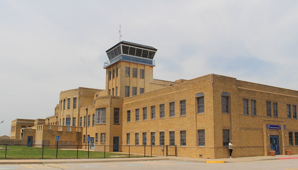
The mid-continent location of Wichita Municipal Airport made it one of the busiest commercial airports in the country: in 1944, a takeoff or landing occurred every 90 seconds. World War II brought significant growth in Wichita’s aviation industry, including a decision by Boeing to build bombers and other aircraft in the city. That expansion, including a new U.S. Air Force base with 6,500 personnel, brought a lot of jobs to the city but it also necessitated relocating Wichita’s airport to a larger facility. By 1954, nearly all commercial and private air traffic was being managed at what is now National Dwight D. Eisenhower National Airport. The original municipal airport facility was used by the USAF and Kansas Air National Guard for a few decades, but the building was eventually abandoned by 1984.

The building and grounds are a perfect location for an aviation history museum, however, and the Wichita Aeronautical Historical Association, leasing the property from the City of Wichita, opened the Kansas Aviation Museum on April 19, 1991. The facility includes a number of large exhibits devoted to different aspects of aviation, including the Engine Room, which displays examples of propellers, landing gear, and engines, many of which were made in Wichita; exhibits detailing the history of Wichita-based aircraft companies like Beech, Cessna, and Ryan International Airlines; and many full-size original private and military aircraft.

Let’s start with a visit to the Engine Room, shall we?
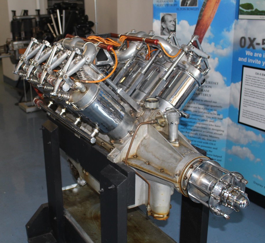
Curtiss OX-5 Engine

This 8-cylinder engine, producing 90 horsepower and 1,400 revolutions per minute, was the powerplant of the Curtiss JN-4 airplane. Known as the “Jenny,” the Curtiss Aeroplane Company developed the aircraft as a trainer for the U.S. Army in 1915. So many pilots learned to fly in the Jenny that it was called “the airplane that taught America to fly.”  Curtiss built a total of 6,813 Model JNs, ending production in 1927. The airplane remained very popular following World War I and was heavily used in the barnstorming craze that led to the rise of civil aviation in the United States. This engine weighs 390 pounds, about a third of the Jenny’s total weight of 1,390 pounds. Nancy and I saw a replica of a JN-3 during our visit to Pancho Villa State Park in New Mexico in December 2021. The state park is the site of the former Camp Furlong, at which the first military airfield in the United States was built in 1916;.

Wright Whirlwind J-5 Engine

This important engine was introduced in 1925 to power a number of aircraft built in Wichita, including the Travel Air 2000, 3000, and 4000, as well as the Laird (later Stearman) Swallow (see below). An engine of this type drove the propeller of the Spirit of St. Louis, a custom-built monoplane, across the Atlantic Ocean during Charles Lindbergh’s first solo transatlantic flight in May 1927. The Wright Whirlwind produced 220 horsepower at 2,000 RPM.

1934 Link Trainer AN-T-18

When I first saw this machine from a distance, I thought it was a toy. Edwin Link’s family produced pianos and organs, and Link used that experience with valves, bellows, and pumps to develop this instrument flight simulator. The machine used organ bellows to make the trainer pitch, roll, and yaw in response to a pilot trainee’s movements.

I wasn’t terribly far off from thinking it was a toy, though. The U.S. Army Air Corps didn’t think much of the simulators at first, and the first sales of the trainer came as carnival rides. However, when 12 Army pilots were killed in a 78-day period due to their lack of training in flying under instrument conditions, the Air Corps was compelled to find a solution. In 1934, Edwin Link flew to a meeting in foggy conditions that were perceived as unflyable, and the Army Air Corps ordered its first six Link Trainers at a cost of $3,500 each. During World War II, more than 10,000 Link Trainers were built to familiarize more than 500,000 U.S. Army and Navy pilots with flying under instrument conditions.

Here’s a pretty nifty display of wooden airplane propellers, all of which were made in Wichita (the one in the middle was constructed by the Supreme Propeller Co. of Wichita).

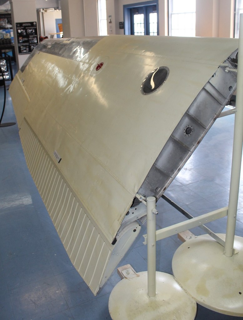
Cessna 206 Super Skywagon Wing

Along with engines and propellors, this section of the museum illustrated how aircraft wings work. The elliptical design of the wing provides lift when the airplane is pulled forward by a propeller or pushed from behind by a jet engine. This is the left wing of a 1964 Cessna 206. The six-seat Super Skywagon was introduced in 1964 and remained in production until 1986 when Cessna ceased production of single-engine aircraft. The company reintroduced the 206 in 1998 and the aircraft remains in production. The 206 model, renowned for its stability and reliability, could carry a thousand pounds of passengers and/or cargo, which led to it being known as “a flying pickup truck.” See below for a picture of a Cessna 206 with both of its wings, along with all its other parts.

General Electric/Allison J35-A-13 Turbojet Engine

In addition to propeller engines, the museum has a good selection of early jet engines. This jet engine was first developed by General Electric in 1946, but the Allison division of General Motors took over production of the engine the following year. More than 14,000 of these engines were built by the time production of the J35 ended in 1955. It was used in a number of experimental aircraft, as well as the production fighters North American FJ-1 Fury, Northrop F-89 Scorpion, and the Republic F-84 Thunderjet (see below). This engine weighs more than 2,800 pounds and produced 5,200 pounds of thrust.

Now, on to the West Hall’s display of vintage aircraft.

Replica of an early 1920s Laird Swallow

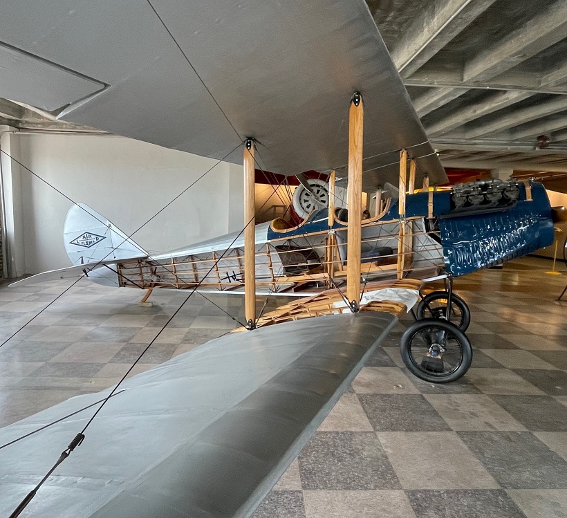
E.M. Laird Airplane Company was formed in Wichita in 1920. The company’s first airplane, the Wichita Tractor, took flight on April 8 of that year, and an onlooker remarked, “She flies like a swallow, boys.” The Laird Swallow was the first commercially produced aircraft in the United States, and only 43 models were constructed. No original Swallows are known to exist, thus this replica (from which the sides of the fuselage have been removed so one can see the inner workings). The Swallow had a top speed of 86 MPH.

An interesting note: a couple of the original principals of the company, Lloyd Stearman and Walter Beech, would later join with Clyde Cessna and Walter Innes to create the Travel Air Company in 1925. Travel Air was the biggest aircraft manufacturer in the United States three years later, and was the prime contributor to Wichita being named the “Air Capital City.”

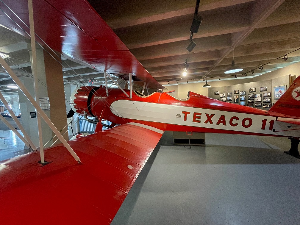
1931 Stearman Model 4D

Developed in 1930 from earlier Stearman designs, the Model 4 was developed with a deeper fuselage and more powerful engine that enabled it to carry heavier cargo loads than its predecessors. This is one of only four Model 4Ds to have been constructed, and a total of 41 Model 4 variants were finished. Stearman Model 4 aircraft were in the fleets of Varney Airlines (now United Airlines), American Airways (now American Airlines), and Standard Oil Company. This particular craft, which sold for about $16,000, was first used by Texaco Oil Company until its retirement in 1936. It was later used for crop dusting, and still later for mosquito control for the Tennessee Valley Authority in Alabama. It had a top speed of 145 MPH and a range of 500 miles, weighing 3,800 pounds. Its wingspan is 38 feet and the length is just shy of 27 feet. The Kansas Aviation Museum completed the restoration of this beautiful airplane, featuring its original livery, in 2014.

1944 Beechcraft D175 Staggerwing

During the U.S. Great Depression, aircraft executive Walter Beech and airplane designer T.A. “Ted” Wells collaborated on a biplane project intended solely for the use of business executives. The Beechcraft Model 17, later known as the “Staggerwing,” first flew on Nov. 4, 1932. The aircraft got its nickname because of the wing configuration: the upper wing was placed behind the lower wing to improve pilot visibility. This aircraft featured retractable landing gear, which was not common at the time, and boasted a range of 670 miles with a top speed of 212 MPH. The wingspan is 32 feet and the craft is almost 27 feet long, with a gross weight of 4,250 pounds. Note that the Wichita Municipal Airport was not originally designed to display aircraft in its interior, and part of the fun of visiting the museum is wondering how the airplanes got into the building for display.

Before going outside to see the aircraft on display out there, take a look at the ceiling above you:

Throughout its usage, beginning as an important midcontinental airport through which aviation luminaries such as Amelia Earhart and Charles Lindbergh walked, up to today’s usage as a museum, the building’s art-deco inspiration has remained intact. These ceiling treatments also acknowledge the building primary use: a home – temporary or permanent – for airplanes.

Now, let’s proceed outside for a look at a few of the 14 aircraft on display.

Republic F-84 Thunderjet

Republic Aviation, based on Long Island, New York, is famous for its design and production of several World-War-II-era and post-war aircraft, including the P-47 Thunderbolt fighter, the F-105 Thunderchief, and the F-84 Thunderjet. First flying in 1946, the Thunderjet was plagued by a variety of problems that nearly caused the U.S. Air Force to cancel the program. However, after some significant design improvements, the F-84 became the Air Force’s primary strike aircraft during the Korean War  and would fly more than 86,000 sorties during that conflict. The Thunderjet was the first production aircraft to be capable of inflight refueling, as well as the first fighter that could carry a nuclear weapon. The F-84 was also the first aircraft to be used by the Air Force Thunderbirds aeronautics team. More than 7,500 F-84s were built. The General Electric/Allison J35-A-13 turbojet engine, shown above, was used in the F-84. With later variations and improvements in performance, the F-84 could fly up to 622 MPH.

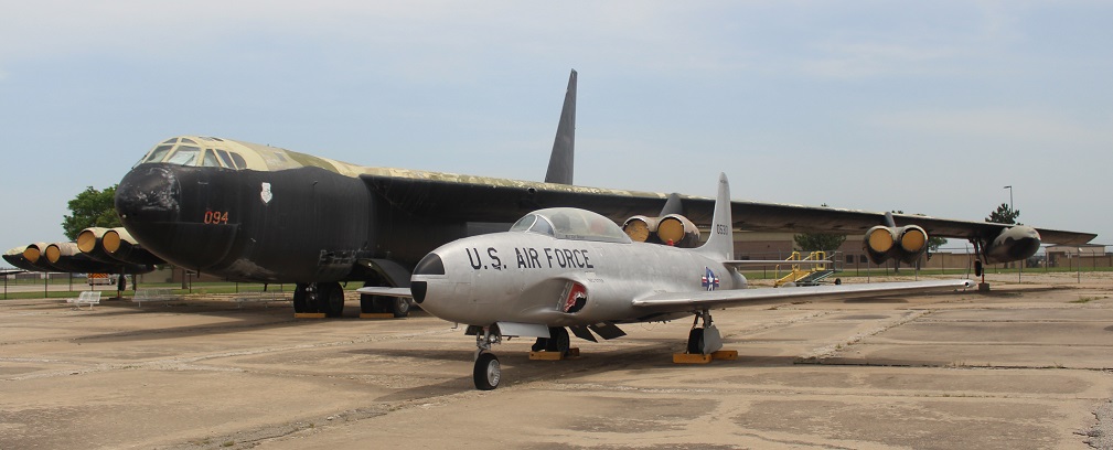
Lockheed T-33B Shooting Star and Boeing B-52D Stratofortress

First flying in 1948, the Lockheed T-33 (shown in foreground) was used by the U.S. Air Force and Navy as a trainer for its jet pilots. More than 6,500 Shooting Stars were manufactured until production ceased in 1959. In addition to the United States, military branches of 43 other countries used the T-33 to train their pilots. The last operator of the T-33, the air force of Bolivia, retired its aircraft in 2017 after having used Shooting Stars for 44 years. The T-33 had a maximum speed of 600 MPH.

You might also notice the Boeing B-52D bomber, the big boy in back of the T-33. Introduced by Boeing in 1952, the jet-powered Stratofortress continues to be in service with the U.S. Air Force and is expected to remain so into the 2050s. It has outlasted more advanced bomber models introduced after it, like the Convair B-58 Hustler, the Rockwell B-1 Lancer, and the Northrop Grumman B-2 Spirit. Originally manufactured in Boeing’s Seattle plant, the B-52 was built in Wichita beginning with this B-52D model in 1957 and continuing through the B-52H model in 1963. A total of 742 B-52s were built in Seattle and Wichita, and about 50 of them are still in service. Powered by eight Pratt & Whitney turbofan engines, the final B-52H production model has a maximum speed of 650 MPH, a service ceiling of 50,000 feet (nine and a half miles above the Earth) and a ferry range (when fully loaded with fuel) of just over 10,000 miles and a combat range (while carrying ordinance) of 8,800 miles. For reference, the diameter of the Earth at the equator is 7,917 miles. With a wingspan of 185 feet, as Nancy pointed out, if a B-52 was parked so that its nose was on the 50-yard line of a football field, its wings would stretch to each of the 20-yard lines (as a comparison, a Boeing 737 passenger airliner has a wingspan of about 117 feet).

Boeing  B-47 Stratojet

We saw an example of this bomber in Albuquerque, New Mexico, during a visit to the National Museum of Nuclear Science & Historyin late 2021, but it was fun to see this aircraft on display in the city in which, like the B-52D above, it was built – the first B-47 was manufactured in 1951, in Wichita. The B-47 was the U.S. Air Force’s first swept-wing bomber capable of flying at both high altitude and supersonic speed, with a maximum speed of 607 mph and a ferry range of more than 6,400 miles. When you fly on a commercial jet airliner today, you’re benefiting from technology and aeronautic advancements that were first made with the development of the Stratojet.

Cessna 206

It’s really rewarding to see examples of Wichita-made military aircraft that, in addition to helping protect our country, led to the development of so many aeronautical innovations we take advantage of when taking a cross-country (or cross-ocean) flight. For me, however, whenever I think of Wichita aircraft companies, my mind first goes to Cessna. My dad, Steve Goering, was born and raised just north of Wichita and got his private pilot’s license as a very young man. He has piloted Cessna models 150, 170, 172 and 182, along with a number of other fixed-wing aircraft and helicopters. This is an example of a Cessna 206, an extraordinarily popular model of aircraft (along with the models 205 and 207) that is used for commercial air service as well as personal use such as aerial photography.

Cessna was founded in Wichita in 1927 by Clyde Cessna and a partner, who quickly sold his share of the company to Cessna. The company was purchased by General Dynamics in 1985, and then by Textron in 1992. It, along with Beechcraft and Hawker Aircraft companies, is now a brand of Textron.

We’ve been to a number of aircraft museums in the months since becoming full-time RVers, but the Kansas Aviation Museum sticks out for me simply because of the history that the city of Wichita has with the science of flying. Its displays will teach you how airplanes fly, either with engine-driven propellers or with jets, and provide you with up-close views of some of the most popular aircraft produced — many in Wichita — in the last 100 years. Seattle, Washington, can certainly be proud of its aviation history as well, but I don’t think there’s a museum showing the depth of home-grown aeronautical innovation – from this Cessna 206 to a Boeing Stratofortress – quite like Wichita’s.

Strataca

May 30, 2022 – Hutchinson, Kansas

In addition to the Cosmosphere, a world-class space science museum, the city of Hutchinson, Kansas, features another prominent attraction: the only salt mine in the country that’s open to the public. Have I got your attention yet? Read on!

Formerly known as the Kansas Underground Salt Museum, Strataca is owned by the Hutchinson Salt Company, which began operations in 1923 as the Carey Salt Company. Nancy and I visited Strataca in late May 2022.

The salt extracted from the mine is not the type that you’ll find in your kitchen salt shaker. There are a number of impurities in the mineral, which makes it ideal for managing icy roads and for feeding livestock.

Strataca’s story begins, as do all of the good ones, in the late part of the Paleozoic Era, known as the Permian Period, about 275 million years ago. Kansas, along with much of the rest of present-day North America, was covered by a vast inland sea. The waters eventually receded, leaving behind an immense deposit of salt that, over tens of millions of years, was covered with layers of shale and other sediments like sand, gypsum, and silt. That 275-million-year-old deposit of salt is now 650 feet below the Kansas prairie.

The museum has been at this location on the east side of Hutchinson since 1986. Of the 15 salt mines in the United States, Strataca (née the Kansas Underground Salt Museum; the name was changed in 2013) is the only one that is open for visitor tours. I’m trying to remember to take pictures of the exteriors of the museums we see; it seems that the American flags are flying at half-mast more often than not. We visited Strataca on Memorial Day.

A double-deck elevator takes two sets of up to 15 people each on a four-minute trip 650 feet down into the bowels of the earth. (It’s not really the bowels of the earth; the top crust of the earth, which makes up about 1% of the radius of our planet, has an average thickness of nine to 12 miles. In other words, the 650-foot elevator ride takes visitors down about 1% of 1% of the earth’s radius. Still, the elevator ride is pretty neat!)

Excavating the shaft for this visitor elevator was no mean feat. In addition to penetrating hundreds of feet of sedimentary rocks, the shaft also had to descend through part of the Ogallala Aquifer – one of the world’s largest natural underground reservoirs. The aquifer is about 130 feet thick at the site of the museum. To construct the shaft, engineers used liquid nitrogen to freeze the area of the aquifer immediately surrounding the planned shaft, then excavated the ice and replaced it with a concrete liner. The process was completed in 15-foot increments, and took just over a year between March 2004 and March 2005.

Upon exiting the elevator, visitors enter a large chamber filled with interesting exhibits that tell the wondrous story of sodium chloride (NaCl). As you can see, every visitor has to wear a hard hat. I jostled my way to get a blue one. The temperature in the mine year-round is 68 degrees Fahrenheit, with a relative humidity of 45%.

Let’s go back topside for a moment. This map, located in the museum’s visitor center, shows the extent of the mine (in yellow) with the rest of the city of Hutchinson to the west (left). The 1.5-square-mile mine is immense; if each of the excavated areas was lined up in a straight line, the chamber would extend for 150 miles. Pillars of solid rock salt, 40 feet square, are left to separate each chamber and support the upper level of salt.

Okay, back down into the bowels of the earth 650 feet below the surface. Here’s a closeup of the salt deposit. As you can see, it’s quite different from the Morton’s that’s in your kitchen cabinet. The sodium chloride is mixed with a number of other minerals, including shale and sulfur compounds, which is why it’s primarily used to de-ice roadways.

The year 2023 will mark a century of mining by the Hutchinson Salt Company (formerly Carey Salt). It mines in the room and pillar process. This involves excavating, with the use of explosives, large chambers alternating with square pillars, measuring 40 square feet, that support the upper level of the mine. The process results in something of a checkerboard pattern, if it could be viewed from above. The mine’s chambers are very large, ranging from 2,500 to 15,000 square feet in size, with ceiling heights of 11 to 17 feet. The room and pillar method differs from traditional precious metal mining, in which miners follow the vein of gold or silver ore, for instance (unless it’s more cost-efficient to simply take an entire mountain apart, which seems to be happening more often).

Strataca has retained a lot of Carey Salt’s equipment from the early days of the mine (I’m guessing partly because it would cost time and money to return them to the surface, but it’s still fun to see the specialized equipment). The machinery is fairly well-preserved, considering the relatively high humidity; the salt can’t be good for metal parts, though. This machine was used to cut long slits at the bottom of a salt wall; when explosives in the wall were detonated, the slit ensured that the salt fragments fell forward into the chamber.

The excavation takes place in much the same way today, but using modernized equipment. The rock salt fragments are transported via conveyors to crushers, then taken to the surface using large buckets on a hoist. When operating at capacity, the skip, or mine elevator, can carry four tons of salt to the surface every three minutes. The skip is also used to transport miners into and out of the operation. Miners formerly used a rail system to move about the operation underground, but have since started using old junk cars that have been modified to run on bio-diesel fuel. Developed almost entirely from old cooking oil, the burning of bio-diesel doesn’t leave particles suspended in the environment. There are many instances of several generations of Hutchinson families being employed by the mine.

This was an interesting exhibit; it’s essentially a waste dump site. Early in the mine’s history, employees would leave their empty food packaging underground because it was more cost-effective to use the skip to transport either rock salt or miners. The salty environment, well away from the sun’s ultraviolet rays, has preserved the trash remarkably well; a lot of the sandwich wrappers and empty drink cups look like they were tossed aside last week instead of in the 1950s.

Nancy and I went on a couple of different guided tram rides through the mine. We got to see chambers that were excavated decades ago, using earlier mining methods. The mining company has placed a number of environmental sensors throughout the operation, which provide early detection of any possible shifting of the rock salt walls. The Mine Safety and Health Administration, which oversees operations in U.S. mines, considers this salt mine one of the safest in the world.

Nancy really enjoys being underground. I mean, really. She’d been looking forward to visiting the Hutchinson salt mine for a number of years, and we both had a great time. Luckily for us, our underground adventures were only beginning – we’d be able to descend into the bowels of the earth natural caves at two U.S. national parks in the months to come. Multiple times at each cave, even!

A salt mine might seem like something of a “so what?” kind of experience. But it’s the salt that comes from this mine, and others like it, that keep our roads safe to drive in wet and freezing weather. We’re glad we went, and, combined with the Cosmosphere, Strataca makes an excellent reason to visit Hutchinson.

The Cosmosphere

Hutchinson, Kansas – May 28, 2022

Hutchinson, Kansas, seems to be an unlikely place for a world-class museum devoted to space exploration. The state’s main economic driver, by far, is agriculture: Kansas ranks in the top 10 states in the country for revenue from beef cattle, corn, hay, hogs, soybeans, sunflowers, and wheat (40 percent of all the winter wheat grown in the United States comes from Kansas).

However, the Sunflower State’s motto is “ad astra per aspera,” which, as you’ll recall from your Latin learnin’, means “To the stars through difficulties.” The motto is more a recognition that the state succeeded despite struggles with Black slavery, relationships with Native Americans reluctant to give away their homelands, and the U.S. Civil War than a resolution to actually travel to space, but I think it’s inspiring nonetheless.

Nancy and I visited the Cosmosphere in late May 2022.

This is a reproduction of the Bell X-1, the jet in which USAF Captain Chuck Yeager first broke the sound barrier (Mach 1, or about 700 mph) on October 14, 1947. The original X-1, Glamorous Glennis, is on display at the National Air & Space Museum in Washington, D.C. Fittingly, the original X-1 is next to the Spirit of St. Louis, in which Charles Lindbergh made the first solo transatlantic flight. The X-Plane program, of which the X-1 was the first craft, began in 1946 as a means of developing aerodynamics, engines, and other factors of high-speed and high-altitude flight. (The idea that the sound barrier was broken the year after the program’s start is, to me, kind of mind-boggling). The breaking of the sound barrier with a straight-wing aircraft came as a surprise to many aerospace experts, who believed that a swept-wing design was necessary for supersonic flight. X-1 flights ended in 1958, and by then the jet had flown at speeds approaching 1,000 mph and at altitudes close to 72,000 feet. In 24 years of testing, more than 40 X-Plane pilots were killed in expanding mankind’s knowledge of aeronautics. The experiments showed, however, that it was possible to break Earth’s gravitational pull and leave the planet’s atmosphere. They helped develop today’s vehicles that soar through our skies and the space around us. (Incidentally, and while it wasn’t necessarily built for speed, the Spirit of St. Louis had a top speed of 133 mph in 1927 – only 20 years before Yeager’s historic flight.)

The Cosmosphere (which is, again, smack-dab in the middle of Kansas) is home to the largest combined collection of U.S. and Russian spaceflight artifacts in the world. Numbering more than 13,000 pieces, the Cosmosphere’s collection is second to only the Smithsonian Institution’s Air and Space Museum for U.S. artifacts and is second only to Moscow for its number of Russian artifacts.

The Cosmosphere’s significant 1997 expansion gave it space to display one of the 20 surviving Lockheed SR-71 Blackbirds. The SR-71 first entered service as a high-altitude reconnaissance aircraft in 1966. The aircraft had a top speed of 2,200 mph (Mach 3.3) with a service ceiling of 85,000 feet, or about 16 miles (the scientists have determined that Earth’s atmosphere ends, and space begins, at about 62 miles above the planet). Lockheed built a total of 32 SR-71s; 12 were lost in accidents but none were destroyed by enemy aircraft (if an oncoming missile was detected, the Blackbird pilot simply went faster). The SR-71 (this particular model has Air Force serial number 61-7961) makes for a really impressive exhibit, but it’s difficult to get a photograph of the entire craft. This was the second SR-71 we’d seen in just two months, we saw AF model 61-7951 at Tucson’s Pima Air & Space Museum in March; most of the other 18 surviving Blackbirds are also on display at aircraft museums and Air Force bases around the country (one is in England)

Given Kansas’s agrarian economy, it shouldn’t be a surprise that the Cosmosphere started as a planetarium, with a used projector and rented folding chairs, in the Poultry Building on the Kansas State Fairgrounds in 1962. It was one of the first public planetariums in the country. Four years later, the planetarium moved to the campus of Hutchinson Community College. In 1980, the Cosmosphere was expanded to a 35,000-square-foot facility, which included one of the country’s first IMAX® Dome Theaters and a three-level exhibit gallery (my first and only other visit to the Cosmosphere occurred sometime in the mid-1980s, while visiting family in Kansas). The Cosmosphere tripled its size in 1997, becoming an impressive 105,000-square-foot facility with room for educational events and other programs.

If you thought that the Moon looked a little smaller after the Apollo 11 mission to the Moon in July 1969, it’s likely because Neil Armstrong and Buzz Aldrin brought back some rocks when they returned to Earth. On exhibit in the lobby of the Cosmosphere, this is one of the few Moon rocks on public display in the world. Armstrong and Aldrin collected this rock during a three-hour walk in the Sea of Tranquility on June 20, 1969. Its mineral composition is basalt, which is an igneous rock formed from rapidly cooling volcanic lava. It weighs just under 5 ounces – it used to be bigger but the scientists cut it in to smaller pieces in order to study it – and the same scientists say that it’s 3.84 billion years old.

The German V-2 Rocket

The Cosmosphere has several large independent exhibits that tell the story of how the space race developed. One of these exhibits focuses on the development of the Vergetlungswaffe 2 (“retaliation weapon 2”), the V-2 rocket, and it’s simply an outstanding experience, with interesting displays of original hardware and plenty of explanatory panels.

It’s safe to say that putting mankind in space, beginning with launching manned rockets into the sky in the early 1960s, progressing to the Apollo missions to the Moon that started in 1969, and continuing with programs like Skylab (1970s), the space shuttles (1980s), and the present-day International Space Station, started with weaponry development during the buildup to World War II. Simply put, many of the other rockets exhibited in the Cosmosphere wouldn’t have been possible without the development of the V-2.

The V-2 rocket on display at the Cosmosphere was discovered in an abandoned warehouse in Huntsville, Alabama. It was acquired by the museum in 1989 and restored by SpaceWorks, a division of the Cosmosphere. The project took several years and restored the rocket to how it would have looked in the period of 1942-1943. The seated figure near the front of the rocket represents a Jewish prisoner; many thousands of Jews were forced to work on the hazardous rockets.

The Nazis sunk incredible financial resources into the development of the V-2, believing it would turn the tide of World War II because of its ability to strike opposing targets from more than 200 miles away. The V-2 was developed by a team led by Dr. Wernher von Braun, a brilliant rocketry scientist whose early work was influenced heavily by the tests performed by Dr. Robert Goddard (early in his career, von Braun corresponded with Goddard regarding the latter’s experiments). Von Braun was very interested in sending mankind to space, and saw the V-2 program as a way to further his research into rocketry. His interest in space exploration almost led to his execution by German officials, who believed von Braun wasn’t sufficiently focused on creating a weapon of destruction and instead wanted to create a way to travel to the stars. Only the doctor’s relationship with a Nazi official who had Hitler’s ear saved his life.

The V-2 was the first long-range guided ballistic missile. Between September 1944 and March 1945, Germany launched more than 3,200 of the rockets at targets in England, Belgium, and other areas in western Europe. The rockets were fired from mobile launch pads, which made it extremely difficult for Allied forces to find and destroy the launch sites. A V-2 firing battery consisted of 152 self-propelled vehicles, 70 trailers, and more than 500 men. Each battery could fire up to nine missiles per day.

A V-2 rocket stood more than 46 feet tall, weighed 27,000 pounds and flew 50 miles into the sky, but the engine was just over five feet long and weighed just over one ton. Incredibly, that engine created 56,600 pounds of thrust while burning 33 gallons of alcohol and liquid oxygen every second.

The rocket carried a one-ton payload of high explosives to the edge of space, 250,000 feet above the earth, more than 200 miles to its target. When it began its return to earth, the V-2 reached speeds of 3,500 miles per hour – faster than the sound that it created, which meant that it exploded on the ground before the thunderous roar of its descent could be heard. Latter-day research has shown that a V-2 explosion created a crater 66 feet wide and 26 feet deep, displacing about 3,000 tons of material. From launch, the V-2 took only 4 minutes to reach its target (for reference, the width of the state of Colorado is a little less than 400 miles, or about twice the distance that a V-2 traveled).

V-2 attacks killed more than 1,700 Belgians in Antwerp, and injured 4,500 more. In London, more than 2,700 civilians were killed by the rockets, with an additional 6,523 injured. As horrid as those numbers are, it’s estimated that development of the V-2 cost the lives of as many as 20,000 people in Germany – most of them Jewish prisoners who died either from overwork or from accidental explosions.

In its time, the V-2 was a defenseless weapon – when everything worked. Fortunately, the rocket involved incredibly complex engineering and everything rarely worked. While the Nazis continually refined the engineering to improve the weapon’s efficiency, the V-2’s development came too late in the war to have the kind of impact the Nazis expected. By war’s end, the development of the V-2 (and its predecessor, the V-1) cost Germany the equivalent of $3 billion – roughly twice the amount of money that the United States poured into the Manhattan Project to produce the atomic bomb.

World War II is ripe for “what-if” scenarios, and the V-2 development is a good one. Considering that the V-2 had an insignificant impact on the war’s outcome, compared to the carnage that occurred otherwise, the money and manpower that it cost could have been allocated to the production of more fighter aircraft and anti-aircraft missiles. If the Germans had better control of the skies over western Europe in 1944, the Allied invasion on D-Day may not have been possible and the slow but steady encirclement of Berlin by Allied and Russian forces wouldn’t have happened.

The exhibit at the Cosmosphere does point out, however, that if the invasion at Normandy hadn’t been possible, Berlin – rather than Hiroshima – may have been the first target of the atomic bomb.

In the immediate aftermath of Germany’s capitulation, both U.S. and Russian forces were on the hunt for von Braun and his team of rocketeers. Both sides wanted the expertise and equipment, but von Braun surrendered to the United States and he and his colleagues were brought to this country. The V-2 was examined and led to the development of the Cold War’s intercontinental ballistic missiles (ICBMs), and, in the interest of science, the rockets that would carry mankind into space beginning in the 1960s.

I’ve struggled – a lot – with how to write about this particular blog posting; it’s one reason I haven’t posted anything for several months, and I considered leaving all of the V-2 material out of it. However, I think it’s important to not shy away from the fact that humans can be horrible to one another. I’ve read a lot about German’s leading up to and including World War II, trying to understand why humans can be horrible. I’ve also read extensively about Wernher von Braun, trying to understand why he contributed his considerable scientific intellect to the development of a terrible weapon that killed thousands upon thousands of innocent people, either in targeted cities or in forced labor. Von Braun was absolutely furious that the Russians were first into space, first with a dog and then with a man, but he lived to see the results of the Apollo program that sent the first men to walk on the moon – using technology that von Braun helped develop while he worked at NASA. I’ve come to the conclusion (and it’s open for revision) that von Braun really did want to expand the science of rocketry – to send mankind into space – and he was able to do that. I’m a big proponent of many facets of space exploration, but I need to be more cognizant that much of that research has come at horrific costs.

There are a great many other fine exhibits (of which I took a lot of photos that seem to have disappeared into the ether; that’s probably okay because this posting would be even longer than it is) at the Cosmosphere, and it’s well worth a visit when you’re in central Kansas. I think I’ve written about this before, that museums like the Cosmosphere are a great opportunity to stretch one’s mind. Even if museums don’t have all of the answers, and, perhaps particularly if they sometimes don’t, it’s never a bad thing to learn.

Kansas Barbed Wire Museum

May 26, 2022 – LaCrosse, Kansas

It’s bold to call a town the Barbed Wire Capital of the WorldTM, but that is indeed what La Crosse, Kansas does. The designation came about because of another of La Crosse’s claims to fame: it’s the home of the Post Rock Museum. But before we get into post rocks, let’s go back to barbed wire (if you really want to read about post rocks, scroll down to the bottom of this post but you’re going to miss out on the truly exciting barbed wire content). In the early 1960s, volunteers at the Post Rock Museum noticed that a large number of visitors took special notice of the small barbed wire exhibit.

La Crosse, Kansas (founded 1876, current population of 1,266 people), is the Barbed Wire Capital of the WorldTM and is home to the Kansas Barbed Wire Museum and the Post Rock Museum (note the structures holding up this sign; read on for more information on those).

In response to that interest, in 1966 a group of La Crosse businesspeople formed the Kansas Barbed Wire Collectors Association. As with any association, it conducted an annual event: the first Barbed Wire Swap and Sell Convention occurred at the Rush County Fairgrounds in May of the following year. More than 2,000 barbed wire collectors and enthusiasts attended the show. La Crosse has since hosted the event each year (the 2022 festival was May 5-7) and that’s one way you get to be called the Barbed Wire Capital of the WorldTM.

This signage is posted prominently on the museum’s exterior. I’ve spent most of my professional career working for nonprofit associations, and I’m still continually surprised at the truth of the statement, “There’s an association for everything.”

Another way is to develop a museum. The first building that housed the Kansas Barbed Wire Collectors Association’s collection of barbed wire and associated materials was a small structure on Main Street in La Crosse. The museum was dedicated on April 30, 1971; the day included a parade as well as appearances and remarks from various local and state dignitaries. The 500-square-foot building was home to displays of 500 types of barbed wire, tools, and other artifacts, the majority of which came from the collections of two Kansas men, Leo Schugart of Hoisington and Don Wigington of Quinter.

If you’re researching barbed wire, sooner or later you’ll be making your way to La Crosse, Kansas. If you’re hungry after studying barbed wire, be sure to visit the JCT 4 Diner, located on the north end of town (the museum is on the south end) and order the chicken-fried steak. Come to think of it, I wonder if there’s a chicken-fried steak museum.

Alas, less than two decades passed before the museum had outgrown the Main Street building. The La Cross chamber of commerce commenced a fundraising campaign to construct a new building, measuring 5,400 square feet, in the town’s Grass Park. The new facility, built in a year, was dedicated on May 4, 1991. The Kansas Barbed Wire Museum, which is owned and operated by the Kansas Barbed Wire Collectors Association, is also home to the Antique Barbed Wire Society’s Historical Research Center as well as its Hall of Fame. The museum welcomes visitors from around the globe each year.

Two of those visitors this year were Nancy and me, in late May. Nancy, recognizing my enthusiasm for barbed wire exhibits during our travels (we’ve seen an impressive number of exhibits in city museums in New Mexico and Arizona), surprised me with an early birthday gift of a visit to the museum. At the time, we were camping in Hays, Kansas, which is located about 25 miles due north of La Crosse. For those unclear or simply unaware of where Hays is, it’s about 160 miles east of the eastern border with Colorado, conveniently located in the north-central part of Kansas on Interstate 70.

The biggest part of the Kansas Barbed Wire Museum is its immense collection of barbed wire varieties, displayed in case behind Plexiglass. (Forgive the glare from the overhead lighting in this photo, but the Plexiglass is probably what you want between barbed wire and you.) I neglected to count, but I would imagine there are a couple of dozen cases (I’m not kidding) like this one. The museum’s collection contains more than 2,400 varieties of barbed wire mostly from the American West of the late 19th century, but also contemporary styles and those from around the world.

You might be asking yourself: “Why is there a museum dedicated to barbed wire?” It’s a fair question, I suppose, and for the answer we must go back to the formation of the North American continent and its place on the earth. Imagine a vertical line hugging the eastern borders of North and South Dakota, continuing south near the eastern border of Nebraska, and then across the eastern thirds of Kansas, Oklahoma, and Texas. That line is the 98th Meridian, meaning that it’s 98 degrees (out of the globe’s 360 degrees) west of the Prime Meridian at Greenwich, England (all meridian lines extend north and south to the poles of the earth). The 98th Meridian is significant because most all of the land in the United States west of that line (with the exception of the Pacific northwest and the west coast) gets less (and some get much less) than about 20 inches of precipitation each year, and everywhere east of that line receives more than 20 inches. To compare five cities in which we’ve recently been:

CityMeridianAnnual inches of precipitation
Tucson, Arizona 111th10.6
Denver, Colorado105th14.3
Hays, Kansas99th (one degree west of the 98th)23.8 (plus an additional 13.9 inches of snow)
Memphis, Tennessee90th53.7
Detroit, Michigan83rd34 (plus an additional 33 inches of snow)

There are altitude-based and other geographic exceptions to the annual precipitation amounts, of course: a mountain town in Colorado such as Ouray, in the San Juans, can receive 20 or 24 inches of rain and almost 12 feet of snow each year. The point is, there are some places in the United States that are better suited to growing moisture-dependent crops such as, say, corn than others.

In the last year of being on the road, Nancy and I have experienced single-event rainstorms in Arkansas and Indiana that would have provided a third of Denver’s annual precipitation. That arid nature of the western United States results in different types of flora (such as buffalograss and saguaro cacti) and fauna (such as desert bighorn sheep and horned lizards), and, to get back to the subject of barbed wire, much fewer trees.

East of the 98th Meridian, trees are pretty common thanks to the arable soils and relatively high levels of precipitation. Because of their ready availability, trees provide wood with which to build fences to contain livestock and protect crops. However, in the high plains of the west, most trees grow naturally only along waterways like year-round rivers or seasonal creek beds; many of those trees, like cottonwoods and mesquite, are not anything with which you’d want to build a house or even construct a livestock fence.

Each of the mounted varieties of barbed wire is accompanied by signage denoting the name of the variety (Ox Pen Wire, Vosburgh Cast Iron Plate, and Scutt’s Early Clip, among others here), along with the U.S. patent number and date of patent, as well as the museum’s unique collection identification number. There are, again, 2,400 varieties of barbed wire on display at the museum, as well as vintage examples of all of the tools used to build and maintain the fencing. Certain people take this sort of thing very seriously, and I’m glad that they do. We all have our personal hobbies and interests, right?

While it doesn’t support any real kind of tree growth, the Great Plains does have a great variety of other plants. The native grasses of the prairies west of the 98th Meridian developed deep-growing roots in order to reach reserves of moisture in the soil. In addition to keeping the soil from blowing away during wind events, the grasses wouldn’t turn over easily with farm implements developed for eastern croplands. Further, those native plants had evolved to need much less moisture to survive than did crops such as wheat and especially corn that grew readily in the eastern United States.

The museum has a cabinet devoted to barbed wire with historical significance, which I found very interesting. Many of this blog’s readers with Kansas roots will remember the tornado that nearly completely destroyed the town of Greensburg, Kansas, on May 4, 2007. One can read the history of this artifact on the signage below the artifact. Greensburg is about 70 miles due south of La Crosse.

Some of the earliest expeditions by the U.S. Army into what is known today as the Great Plains showed that the land probably wasn’t fit for much at all. In an 1810 journal recounting his adventures in the U.S. West, First Lieutenant Zebulon Pike wrote “these vast plains of the western hemisphere may become in time (as) equally celebrated as the sandy deserts of Africa.” Major Stephen H. Long, who traveled more than 26,000 miles in five expeditions across the West, in 1820 called the area “a great desert,” which later led to the term “the Great American Desert.” The plains area from present-day Nebraska south to Oklahoma was, according to Long, “unfit for cultivation and of course uninhabitable by a people dependent on agriculture.”

This display, mounted high in the rafters of the museum, was one of the exhibits in the museum’s first building and brought to the new facility. It is a nest built by crows almost entirely of wire, much of which is of the barbed variety. The nest was found in Greeley County, Kansas, which is along the border with Colorado in the far west part of the state. In the exhibit, the wires are real; the crows are not but they give a sense of scale to the 72-pound display. Nests like these are found in the arms of utility poles and on windmill towers.

The passage of time shows that both Zebulon Pike and Stephen Long were wrong* about the prospects of people living in the High Plains. However, it took unimaginable hard labor, perseverance, and technological breakthroughs, in addition to that passage of time, to prove them incorrect. In 1820, the entire United States had a population of less than 10 million. Today, more than 14.5 million people live in the states of Nebraska, Kansas, Oklahoma, and Colorado. The Front Range of Colorado, which stretches from Pueblo in the south to Fort Collins in the north, has a population of more than 5 million people alone [and the Front Range also has views of two of Colorado’s most prominent mountains, Pikes Peak (elev. 14,115 feet) and Longs Peak (elev. 14,259 feet); I don’t know why the names don’t have possessive apostrophes, but these namesakes show that you can get mountains named after you even if you’re wrong].

*Actually, I don’t know that Pike and Long were entirely wrong. At least along the Front Range, that population of 5 million people is largely possible only by water being brought from somewhere else: snow runoff in western Colorado rivers that’s diverted under the Continental Divide to the Front Range, and water being pulled from the underground Denver Basin aquifer through wells. States downstream from Colorado are making increased (and, to this point, entirely legal) demands for Colorado’s western slope water, and the Denver Basin took tens of thousands of years to fill but is now being further depleted every year. Many farms in eastern Colorado and western Kansas and other parts of the area irrigate their corn (the crop doesn’t have much of a chance of success in the Great Plains without irrigation) with a lot of water pulled from the Ogallala Aquifer, which is being similarly and rapidly depleted, without a possibility of being refilled on a human timescale.

But I digress. Back to barbed wire. The 98th Meridian, then, served as a kind of barrier to westward expansion of the United States during and after the U.S. Civil War. The native grasslands were too tough to efficiently plow for use as cropland, and there was no guarantee that there would be enough precipitation to help crops survive even if their seeds could be planted. Add to that the fact that there was very little lumber for building or burning, and it was a land most inhospitable for development.

I haven’t played chess in quite a long while, but I still found this chessboard and piece display a lot of fun. Each type of piece is made from a different variety of barbed wire, identified by a nearby placard (ex., the two kings are made from Wing Staple Barb, patented in 1878; the four knights are Merrill’s “Twirl,” patented in 1874; the 16 pawns are made from Glidden’s “Oval,” patented in 1876).

What was the land, which supported at the time only a number of nomadic Native American tribes that hunted immense herds of bison and other native animals, good for? Well, some folks decided it could support cattle. Between 1866 (the year after the Civil War ended) and 1880, nearly 5 million head of cattle were driven from Texas north into Kansas and beyond for transport by railcars back east.

Barbed wire is also very effective at limiting the movement of people. This section of wire, along with the fragments of concrete, was taken from the Berlin Wall after that structure fell due to extraordinary social revolutions in late-1980s eastern Europe. The wall, for which construction began in 1961, separated the countries of East Germany and West Germany for nearly 30 years, until November 30, 1989. The museum devotes a lot of display space to exhibits of other barbed wire used for human containment, such as concertina wire, providing welcome food for thought beyond the wire’s use for livestock and crop fencing.

Along the way, some cattle were sold to ranchers in Texas, as well as present-day Oklahoma, Kansas, and other states. Those cattle helped establish ranches that, in a few cases, are still around today. The Homestead Act, signed into law in 1862, brought droves of people to the west with the intent of acquiring free land upon which they could build homes and develop farms. Moreover, the railroads, in addition to transporting cattle east, brought more people from the eastern United States to the west where public sentiment thought it increasingly likely that livings, if not fortunes, could be made – despite the treeless aspect of the plains.

Those eastern sentiments, such as putting up fences to protect their crops and livestock, conflicted with the open range rights that the cattlemen enjoyed. However, the plains still weren’t any good at providing trees with which one could make fences. Until farmers could cost-effectively keep free-range cattle from tromping their crops and their own livestock from wandering away into the vast expanse of the plains, there was no way for livings to be made. That changed on November 24, 1874, when Joseph Glidden was awarded a patent for barbed wire.

Glidden (January 18, 1813 – October 9, 1906) was an Illinois farmer (I’m writing this blog posting at Kankakee River State Park in Illinois, about 90 miles southeast of Glidden’s farmstead in DeKalb) who developed one of the first methods of mass-producing barbed wire using a coffee mill to create the preliminary experimental barbs. With another twisted wire keeping the barbs in place, Glidden developed “The Winner,” which he considered his best design effort and for which he received the U.S. patent. The development was an immediate success and quickly found its way west, where, since much less wood was needed to build fences, it ended the open range era of the American west and it turned the Great Plains into innumerable pastures. When he died in 1906, Glidden was one of the richest men in America.

Today, drive along any road – multi-lane paved Interstate highway or dusty gravel byway – in the West and you’ll likely see galvanized steel barbed wire fencing that can stretch for miles on into the horizon. It’s cheap, durable, and relatively simple to install, without the use of much wood (except where there isn’t any wood; see below).

Joseph Glidden may get the majority of the praise for popularizing barbed wire, but there were others before and after him who produced it.

Glidden’s “The Winner” wasn’t the only barbed wire design, and many before and many after him developed their own styles that they thought would work better in certain situations or environments. Those hundreds of other barbed wire designs, all with the intent of keeping animals in (or out) of a certain area, kept and continue to help keep Americans and the world fed and clothed for generations – and that’s the reason there’s a Kansas Barbed Wire Museum.

What to Do When There’s No Wood

Prior to the coming of the railroads to the west in the late 19th century, vast tracts of lands in the west couldn’t be fenced because there were no trees with which to provide wooden posts and rails. Even after the continent was crossed and after barbed wire was easily available, wood was still scarce and therefore best reserved for building living and work structures.

But spools of barbed wire can’t be used to build a fence without some sort of solid material used for a post, so what do you do? In the case of central Kansas, you use readily available material: rocks. Present-day Kansas, like much of the rest of America, was once under a great inland sea. Over millions of years, organic material from recently departed marine creatures fell to the sea bottom, and over further millions of years was compacted into a rock called limestone.

La Crosse’s original claim to fame was the Post Rock Museum, inside which are exhibits detailing the techniques and tools used to extract limestone used for fenceposts and other construction needs (such as for the Post Rock Museum itself and many other buildings in the area). The Post Rock Museum now shares the limelight with the Kansas Barbed Wire Museum; happily, the two are about 20 feet apart from each other.

The inland sea eventually drained away and, millions of years later, left present-day Kansas relatively dry and treeless under buffalograss-covered topsoil. Needing materials which which to build fenceposts, early settlers resorted to extracting the limestone rocks from just under the area’s topsoil. The area in which the limestone rests covers a 200-mile-long swath of Kansas land stretching southwest from the north-central border with Nebraska to about the location of Dodge City (a town, like many others in Kansas, that was made possible by the cattle trails of the late 19th century) in the southern part of the state. The swath measures in width from 10 to 60 miles wide. Farmers and people who specialized in quarrying post rocks would spend a day extracting about 25 posts, each of which could weigh between 200 and 450 pounds, from the ground.

This example of a post rock fence is adjacent to the Post Rock Museum, which originally had a relatively small display of barbed wire artifacts in addition to its primary focus of exhibits about extracting the posts from the ground. The popularity of the barbed wire display led to the establishment of the Kansas Barbed Wire Museum, now located directly next to the Post Rock Museum. See also the photos of post rocks used in the sign supports for the Kansas Barbed Wire Museum and the Antique Barbed Wire Society’s Historical Research Center at the top of this post – kind of brings it full-circle, don’t you think?

Because of their strength and stability, post rocks were needed only every 30 feet or so to support a barbed wire fence. Today, with the ready availability of steel and treated wood posts, post rocks aren’t nearly as high in demand. But in their heyday, from the mid 1880s to 1920s, post rocks were found in 40,000 miles of fencing in that swath of central Kansas – and, because of their durability (they’re rocks), many are still in use.

Back to Barbed Wire

Barbed wire, at first glance, may not seem like a significant development. But without it, the expansion of Anglo-Europeans westward across the 98th Meridian would have been, at best, substantially delayed. Beyond the economics and geographic expansion, barbed wire had huge cultural impacts as well: because it disrupted the migration of bison herds, barbed wire also led to the displacement of dozens of Native American tribes that had considered the region their homeland for many generations. Barbed wire, with a solid assist from the railroads, is what made the Anglo-European development of the Great Plains possible.

Website Built with WordPress.com.

Up ↑