
May 26, 2022 – LaCrosse, Kansas
It’s bold to call a town the Barbed Wire Capital of the WorldTM, but that is indeed what La Crosse, Kansas does. The designation came about because of another of La Crosse’s claims to fame: it’s the home of the Post Rock Museum. But before we get into post rocks, let’s go back to barbed wire (if you really want to read about post rocks, scroll down to the bottom of this post but you’re going to miss out on the truly exciting barbed wire content). In the early 1960s, volunteers at the Post Rock Museum noticed that a large number of visitors took special notice of the small barbed wire exhibit.

In response to that interest, in 1966 a group of La Crosse businesspeople formed the Kansas Barbed Wire Collectors Association. As with any association, it conducted an annual event: the first Barbed Wire Swap and Sell Convention occurred at the Rush County Fairgrounds in May of the following year. More than 2,000 barbed wire collectors and enthusiasts attended the show. La Crosse has since hosted the event each year (the 2022 festival was May 5-7) and that’s one way you get to be called the Barbed Wire Capital of the WorldTM.
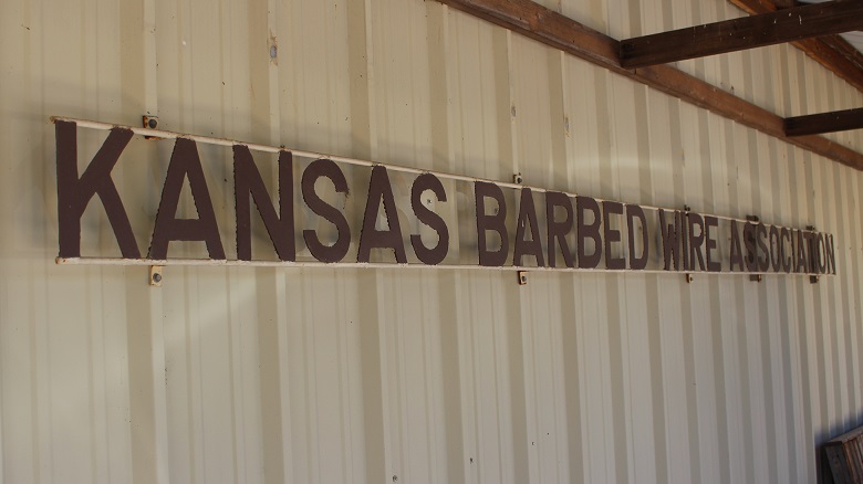
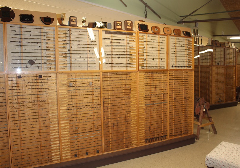
Another way is to develop a museum. The first building that housed the Kansas Barbed Wire Collectors Association’s collection of barbed wire and associated materials was a small structure on Main Street in La Crosse. The museum was dedicated on April 30, 1971; the day included a parade as well as appearances and remarks from various local and state dignitaries. The 500-square-foot building was home to displays of 500 types of barbed wire, tools, and other artifacts, the majority of which came from the collections of two Kansas men, Leo Schugart of Hoisington and Don Wigington of Quinter.
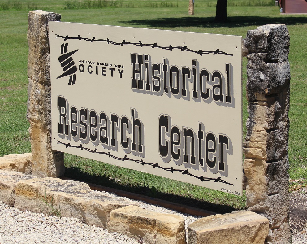
Alas, less than two decades passed before the museum had outgrown the Main Street building. The La Cross chamber of commerce commenced a fundraising campaign to construct a new building, measuring 5,400 square feet, in the town’s Grass Park. The new facility, built in a year, was dedicated on May 4, 1991. The Kansas Barbed Wire Museum, which is owned and operated by the Kansas Barbed Wire Collectors Association, is also home to the Antique Barbed Wire Society’s Historical Research Center as well as its Hall of Fame. The museum welcomes visitors from around the globe each year.
Two of those visitors this year were Nancy and me, in late May. Nancy, recognizing my enthusiasm for barbed wire exhibits during our travels (we’ve seen an impressive number of exhibits in city museums in New Mexico and Arizona), surprised me with an early birthday gift of a visit to the museum. At the time, we were camping in Hays, Kansas, which is located about 25 miles due north of La Crosse. For those unclear or simply unaware of where Hays is, it’s about 160 miles east of the eastern border with Colorado, conveniently located in the north-central part of Kansas on Interstate 70.
You might be asking yourself: “Why is there a museum dedicated to barbed wire?” It’s a fair question, I suppose, and for the answer we must go back to the formation of the North American continent and its place on the earth. Imagine a vertical line hugging the eastern borders of North and South Dakota, continuing south near the eastern border of Nebraska, and then across the eastern thirds of Kansas, Oklahoma, and Texas. That line is the 98th Meridian, meaning that it’s 98 degrees (out of the globe’s 360 degrees) west of the Prime Meridian at Greenwich, England (all meridian lines extend north and south to the poles of the earth). The 98th Meridian is significant because most all of the land in the United States west of that line (with the exception of the Pacific northwest and the west coast) gets less (and some get much less) than about 20 inches of precipitation each year, and everywhere east of that line receives more than 20 inches. To compare five cities in which we’ve recently been:
| City | Meridian | Annual inches of precipitation |
| Tucson, Arizona | 111th | 10.6 |
| Denver, Colorado | 105th | 14.3 |
| Hays, Kansas | 99th (one degree west of the 98th) | 23.8 (plus an additional 13.9 inches of snow) |
| Memphis, Tennessee | 90th | 53.7 |
| Detroit, Michigan | 83rd | 34 (plus an additional 33 inches of snow) |
There are altitude-based and other geographic exceptions to the annual precipitation amounts, of course: a mountain town in Colorado such as Ouray, in the San Juans, can receive 20 or 24 inches of rain and almost 12 feet of snow each year. The point is, there are some places in the United States that are better suited to growing moisture-dependent crops such as, say, corn than others.
In the last year of being on the road, Nancy and I have experienced single-event rainstorms in Arkansas and Indiana that would have provided a third of Denver’s annual precipitation. That arid nature of the western United States results in different types of flora (such as buffalograss and saguaro cacti) and fauna (such as desert bighorn sheep and horned lizards), and, to get back to the subject of barbed wire, much fewer trees.
East of the 98th Meridian, trees are pretty common thanks to the arable soils and relatively high levels of precipitation. Because of their ready availability, trees provide wood with which to build fences to contain livestock and protect crops. However, in the high plains of the west, most trees grow naturally only along waterways like year-round rivers or seasonal creek beds; many of those trees, like cottonwoods and mesquite, are not anything with which you’d want to build a house or even construct a livestock fence.

While it doesn’t support any real kind of tree growth, the Great Plains does have a great variety of other plants. The native grasses of the prairies west of the 98th Meridian developed deep-growing roots in order to reach reserves of moisture in the soil. In addition to keeping the soil from blowing away during wind events, the grasses wouldn’t turn over easily with farm implements developed for eastern croplands. Further, those native plants had evolved to need much less moisture to survive than did crops such as wheat and especially corn that grew readily in the eastern United States.

Some of the earliest expeditions by the U.S. Army into what is known today as the Great Plains showed that the land probably wasn’t fit for much at all. In an 1810 journal recounting his adventures in the U.S. West, First Lieutenant Zebulon Pike wrote “these vast plains of the western hemisphere may become in time (as) equally celebrated as the sandy deserts of Africa.” Major Stephen H. Long, who traveled more than 26,000 miles in five expeditions across the West, in 1820 called the area “a great desert,” which later led to the term “the Great American Desert.” The plains area from present-day Nebraska south to Oklahoma was, according to Long, “unfit for cultivation and of course uninhabitable by a people dependent on agriculture.”

The passage of time shows that both Zebulon Pike and Stephen Long were wrong* about the prospects of people living in the High Plains. However, it took unimaginable hard labor, perseverance, and technological breakthroughs, in addition to that passage of time, to prove them incorrect. In 1820, the entire United States had a population of less than 10 million. Today, more than 14.5 million people live in the states of Nebraska, Kansas, Oklahoma, and Colorado. The Front Range of Colorado, which stretches from Pueblo in the south to Fort Collins in the north, has a population of more than 5 million people alone [and the Front Range also has views of two of Colorado’s most prominent mountains, Pikes Peak (elev. 14,115 feet) and Longs Peak (elev. 14,259 feet); I don’t know why the names don’t have possessive apostrophes, but these namesakes show that you can get mountains named after you even if you’re wrong].
*Actually, I don’t know that Pike and Long were entirely wrong. At least along the Front Range, that population of 5 million people is largely possible only by water being brought from somewhere else: snow runoff in western Colorado rivers that’s diverted under the Continental Divide to the Front Range, and water being pulled from the underground Denver Basin aquifer through wells. States downstream from Colorado are making increased (and, to this point, entirely legal) demands for Colorado’s western slope water, and the Denver Basin took tens of thousands of years to fill but is now being further depleted every year. Many farms in eastern Colorado and western Kansas and other parts of the area irrigate their corn (the crop doesn’t have much of a chance of success in the Great Plains without irrigation) with a lot of water pulled from the Ogallala Aquifer, which is being similarly and rapidly depleted, without a possibility of being refilled on a human timescale.
But I digress. Back to barbed wire. The 98th Meridian, then, served as a kind of barrier to westward expansion of the United States during and after the U.S. Civil War. The native grasslands were too tough to efficiently plow for use as cropland, and there was no guarantee that there would be enough precipitation to help crops survive even if their seeds could be planted. Add to that the fact that there was very little lumber for building or burning, and it was a land most inhospitable for development.

What was the land, which supported at the time only a number of nomadic Native American tribes that hunted immense herds of bison and other native animals, good for? Well, some folks decided it could support cattle. Between 1866 (the year after the Civil War ended) and 1880, nearly 5 million head of cattle were driven from Texas north into Kansas and beyond for transport by railcars back east.

Along the way, some cattle were sold to ranchers in Texas, as well as present-day Oklahoma, Kansas, and other states. Those cattle helped establish ranches that, in a few cases, are still around today. The Homestead Act, signed into law in 1862, brought droves of people to the west with the intent of acquiring free land upon which they could build homes and develop farms. Moreover, the railroads, in addition to transporting cattle east, brought more people from the eastern United States to the west where public sentiment thought it increasingly likely that livings, if not fortunes, could be made – despite the treeless aspect of the plains.
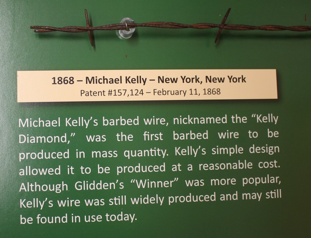
Those eastern sentiments, such as putting up fences to protect their crops and livestock, conflicted with the open range rights that the cattlemen enjoyed. However, the plains still weren’t any good at providing trees with which one could make fences. Until farmers could cost-effectively keep free-range cattle from tromping their crops and their own livestock from wandering away into the vast expanse of the plains, there was no way for livings to be made. That changed on November 24, 1874, when Joseph Glidden was awarded a patent for barbed wire.
Glidden (January 18, 1813 – October 9, 1906) was an Illinois farmer (I’m writing this blog posting at Kankakee River State Park in Illinois, about 90 miles southeast of Glidden’s farmstead in DeKalb) who developed one of the first methods of mass-producing barbed wire using a coffee mill to create the preliminary experimental barbs. With another twisted wire keeping the barbs in place, Glidden developed “The Winner,” which he considered his best design effort and for which he received the U.S. patent. The development was an immediate success and quickly found its way west, where, since much less wood was needed to build fences, it ended the open range era of the American west and it turned the Great Plains into innumerable pastures. When he died in 1906, Glidden was one of the richest men in America.
Today, drive along any road – multi-lane paved Interstate highway or dusty gravel byway – in the West and you’ll likely see galvanized steel barbed wire fencing that can stretch for miles on into the horizon. It’s cheap, durable, and relatively simple to install, without the use of much wood (except where there isn’t any wood; see below).
Glidden’s “The Winner” wasn’t the only barbed wire design, and many before and many after him developed their own styles that they thought would work better in certain situations or environments. Those hundreds of other barbed wire designs, all with the intent of keeping animals in (or out) of a certain area, kept and continue to help keep Americans and the world fed and clothed for generations – and that’s the reason there’s a Kansas Barbed Wire Museum.
What to Do When There’s No Wood
Prior to the coming of the railroads to the west in the late 19th century, vast tracts of lands in the west couldn’t be fenced because there were no trees with which to provide wooden posts and rails. Even after the continent was crossed and after barbed wire was easily available, wood was still scarce and therefore best reserved for building living and work structures.
But spools of barbed wire can’t be used to build a fence without some sort of solid material used for a post, so what do you do? In the case of central Kansas, you use readily available material: rocks. Present-day Kansas, like much of the rest of America, was once under a great inland sea. Over millions of years, organic material from recently departed marine creatures fell to the sea bottom, and over further millions of years was compacted into a rock called limestone.

The inland sea eventually drained away and, millions of years later, left present-day Kansas relatively dry and treeless under buffalograss-covered topsoil. Needing materials which which to build fenceposts, early settlers resorted to extracting the limestone rocks from just under the area’s topsoil. The area in which the limestone rests covers a 200-mile-long swath of Kansas land stretching southwest from the north-central border with Nebraska to about the location of Dodge City (a town, like many others in Kansas, that was made possible by the cattle trails of the late 19th century) in the southern part of the state. The swath measures in width from 10 to 60 miles wide. Farmers and people who specialized in quarrying post rocks would spend a day extracting about 25 posts, each of which could weigh between 200 and 450 pounds, from the ground.
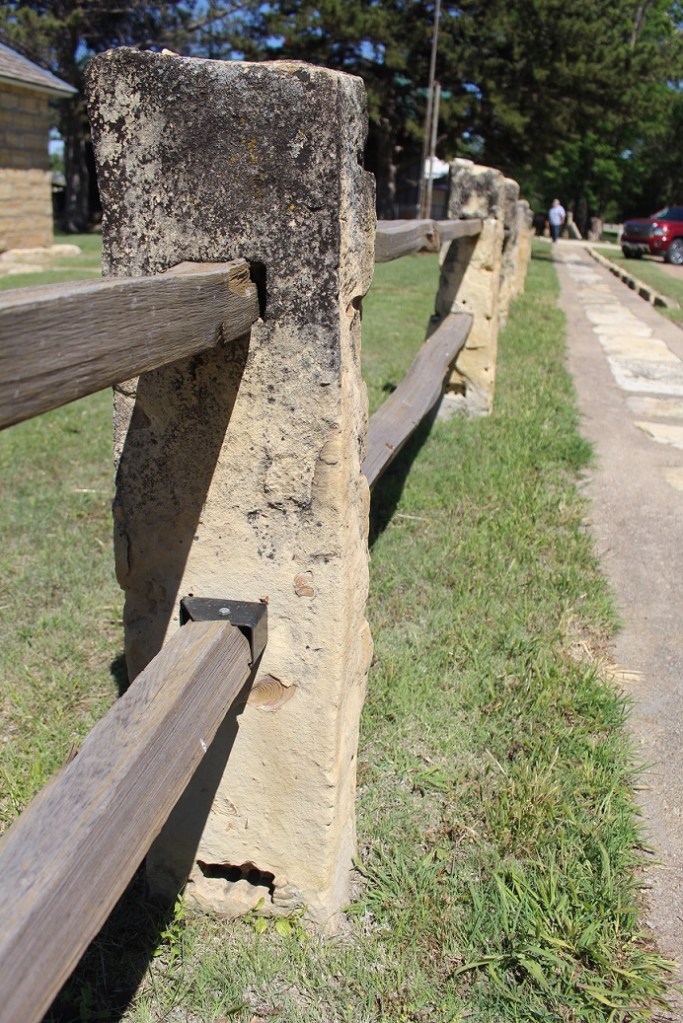
Because of their strength and stability, post rocks were needed only every 30 feet or so to support a barbed wire fence. Today, with the ready availability of steel and treated wood posts, post rocks aren’t nearly as high in demand. But in their heyday, from the mid 1880s to 1920s, post rocks were found in 40,000 miles of fencing in that swath of central Kansas – and, because of their durability (they’re rocks), many are still in use.
Back to Barbed Wire
Barbed wire, at first glance, may not seem like a significant development. But without it, the expansion of Anglo-Europeans westward across the 98th Meridian would have been, at best, substantially delayed. Beyond the economics and geographic expansion, barbed wire had huge cultural impacts as well: because it disrupted the migration of bison herds, barbed wire also led to the displacement of dozens of Native American tribes that had considered the region their homeland for many generations. Barbed wire, with a solid assist from the railroads, is what made the Anglo-European development of the Great Plains possible.
