When I was a boy, growing up in the town of Flagler (population: around 600 in the 1980s) in eastern Colorado, there wasn’t much to do in one’s free time but I never got bored.
Flagler was very fortunate to have a movie theater that presented movies on weekend nights, except on those weekend nights when the Flagler Panthers hosted high school football, basketball, and volleyball games since everyone went to those instead of “the Show,” as we called it. That theater, still in operation and sporting a new digital projector and new seating, was where I first saw movies like “Raiders of the Lost Ark” (1981) and “E.T. the Extraterrestrial” (1982), instilling in me a deep and lifelong appreciation of the movies.
For more entertainment, there was a reservoir a few miles east of town that was so full when we first moved to Flagler in 1979 that the lake was overflowing its impoundment dam. It was a favorite destination for eastern Colorado anglers and waterskiers – unthinkable now because, due to agricultural demands for water downstream, the reservoir has been no more than a muddy drainage of the Republican River for many, many years.
I remember my high school chums and I, perhaps after the Show, cruising the six blocks of Flagler’s Main Street in our vehicles on weekend nights by putting the transmission in “D” and taking our foot off the brake. It provided some good times, at three miles an hour.
Much of the lack of boredom of my childhood is due to the many other pastimes available in eastern Colorado: museums, other movie theaters, and attractions like the World’s Wonder View Tower.
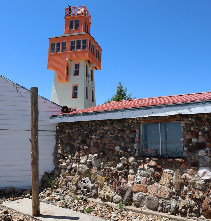
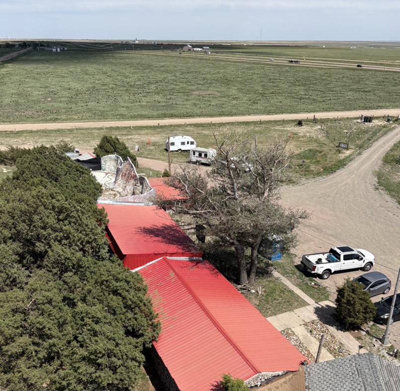
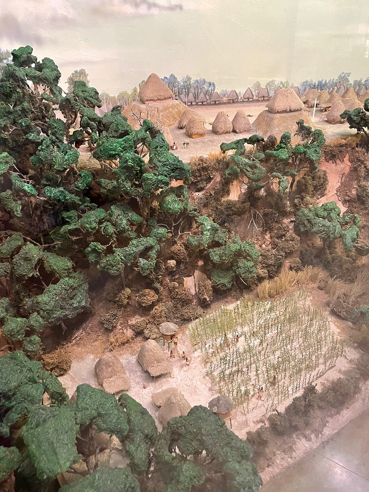
The rock building in the foreground is the museum part of the World’s Wonder View Tower, with the namesake attraction just behind on the left. When I was a boy, the entrance to the museum and the tower was a door just to the right of the window in front. Note the wide variety of rocks used in the building’s construction. Note also a person at the top of the tower; I was to later discover that was either my old Flagler high school chum Gary Beedy, or Gary’s brother, Steve. The Beedy brothers, fourth-generation Genoa-area farmers, are strong supporters of the World’s Wonder View Tower’s restoration and happened to be at the tower the same day we were, and we were pleasantly surprised to see them in the tower’s entrance a few minutes after I took this photo. Eastern Colorado comprises about 40,000 square miles (making it about the size of the entire state of Kentucky), but it can sometimes be a mighty small place.
Located 25 miles west of Flagler in Genoa, Colorado (population in the 2020 U.S. Census: 153), the complex that includes the World’s Wonder View Tower was built in 1926 by Charles Gregory and his partner, Myrtle LeBow. Genoa itself was named after the sixth-largest city in Italy and was located near a natural spring that had attracted wildlife, Native Americans, and Anglo-American explorers to this high spot on the arid plains. Gregory had camped in the area in his younger days, and returned to Genoa to build a top-flight tourist attraction that happened to be right next to a new United States highway.
The decade of the 1920s saw huge growth in the popularity of seeing the United States by automobile, which was further aided by the development of the U.S. Numbered Highway System in 1926. Gregory and LeBow originally built a roadside stop at this location that included a gas station, café, and stage for entertainment. The couple later expanded the amenities to include guest rooms and the 65-foot-tall tower structure.
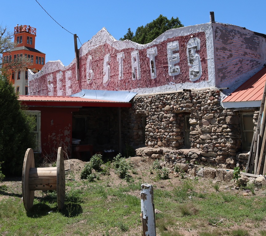
This faded façade is one of my lasting memories of visiting the World’s Wonder View Tower (we just called it “the Genoa Tower,” and no one seemed confused about what we were discussing). The current stewarding organization of the tower complex has focused its efforts on restoring the World’s Wonder View Tower itself, and rightly so.
When completed, the World’s Wonder View Tower, which begins at Genoa’s elevation of 5,604 feet (1,708 m) was the highest point between the Palmer Divide of the Rocky Mountains to the west and the mountains of the eastern United States. The tremendous height of the tower affords simply spectacular views in all directions of the compass.
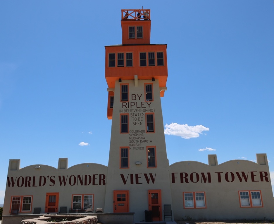
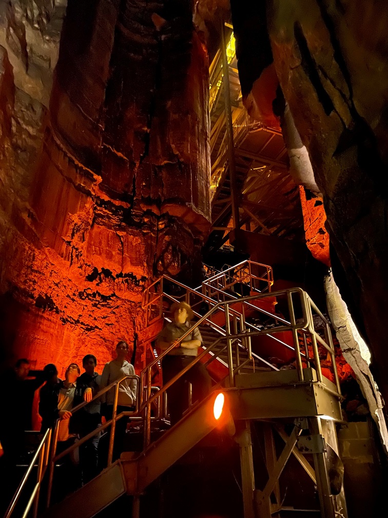
In 1933, no less an authority than Ripley’s Believe It Or Not confirmed that six states – Kansas, Wyoming, South Dakota, Nebraska, New Mexico, and, of course, Colorado – could be seen from the top of the 65 tower. Our tour guide on our June 2026 visit, who accompanied our group to the top, used the word “technically” fairly often when she spoke about the opportunity to see a half-dozen states, such as “Technically, you can see South Dakota.” I finally said “You’re throwing the word ‘technically’ around quite a lot …” and she responded with the expected (and I’m paraphrasing), “We just don’t want to wind up in litigation.” Completely fair, I think.
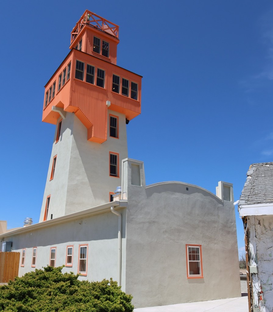
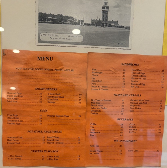
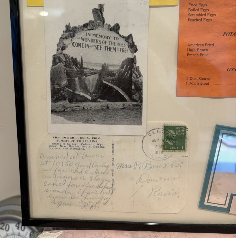
This picture was taken from the east side of the World’s Wonder View Tower. The tower’s original entrance was here on the east side because U.S. Highway 40N (which would be redesignated U.S. Highway 24 in 1936) passed by the tower a few yards to the north. In the 1970s, with the development of Interstate 70 south of the tower, the attraction’s entrance was moved to the south side for easier accessibility. When restoring the tower, the entrance was re-located back to this side of the building. I believe that’s Gary and Steve Beedy still at the top of the tower; I don’t know if they could see the six states of Colorado, Wyoming, Nebraska, South Dakota, Kansas, and New Mexico, but they could almost certainly see their farm located a few miles north of Genoa. Gary and Steve’s great-grandparents first homesteaded the farm in 1893, 33 years before Gregory and LeBow began building this attraction.Here’s a look at the 65-foot-tall World’s Wonder View Tower from its southwest corner. Jerry Chubbuck built an apartment for his family that connected the building on the left with the one on the right; See Six States LLC restored the two buildings to their original and individual states. The new paint job, based on historic photos of the buildings, looks fantastic.In a frame and behind glass inside the tower’s entrance, here are a postcard (“THE TOWER – – Genoa, Colo. Summit of the Plains”) and a menu from when the tower had a café. Nancy and I both wondered about the provenance of OYSTERS IN SEASON. I wouldn’t pass up a piece of apple pie, though, especially at 10 cents.To the lower left of the menu, here are a couple more historic postcards. The bottom one, which has a Genoa (Colorado, not the capital of Liguria in Italy) postmark of April 7, 1950, is addressed to Mrs. R. Bowers of Downs, Kansas (located in the north-central part of the Sunflower State), and reads: “Arrived at tower at 10:50. Good luck so far. Had a stack” (presumably of pancakes, although they’re not on the menu pictured above) “as big as a 5-layer cake for breakfast, wonder if we could ever be hungry again.”This is a picture of a picture at the tower’s entrance of Jerry Chubbuck (October 22, 1930 – August 4, 2013), who owned the World’s Wonder View Tower from 1967 until he passed away. Jerry, who was born in Arriba, Colorado, about 13 miles east of Genoa, was a fascinating person with wide-ranging interests in archeology, geology, paleontology, Native American cultures, and more. He converted the tower’s overnight guest rooms, café, and other rooms into a winding museum that was sort of overwhelming in its scope. It contained exhibits of thousands of arrowheads, dozens of telegraph and telephone line insulators, mammoth fossils (that he discovered), a taxidermied two-headed calf, World War I and World War II-era military memorabilia, petrified wood samples and other rock collections that went on forever, old and obscure farm and ranch tools and machinery, and much more. Jerry had stories about nearly everything under the museum’s roof, and I have fond memories of Jerry greeting visitors at the front door, collecting one dollar in admission, and then offering to refund their dollar if they could guess what historic artifact (usually some sort of old and obscure farm tool or implement) he happened to be holding in his hand. I’m here to tell you: there were some weird and specialized things manufactured in the old days, and I never, despite Jerry’s patience and hints, got my dollar back from any of my visits. Under Jerry’s stewardship of the Genoa Tower, it became a pretty famous landmark along Interstate 70. My other lasting memory of Jerry, who obviously loved sharing his knowledge with others: after telling you what some artifact was and how to use it, he’d end his sentences with, “Yep. Uh-huh. R-i-i-i-ght.” I think the world needs more people like Jerry Chubbuck.
Jerry passed away in 2013, and the site fell into disuse for several years until some Colorado history aficionados, determined to save the property from fading from the map, formed a limited liability corporation (enigmatically called “See Six States LLC”) to acquire the tower and surrounding buildings and land. See Six States LLC put the property in the hands of a nonprofit group called Friends of the Genoa Tower, the board members of which include Patricia Calhoun, who co-founded the Denver alternative weekly newspaper Westword in 1977 and was, until her pending retirement in the summer of 2026, the newspaper’s editor-in-chief. Troy McCue, another high-school chum of mine, is also a member of the Friends of the Genoa Tower board; he’s now the executive director of Lincoln County Economic Development, which promotes and maintains job creation and business growth in this eastern Colorado county in which Genoa is located.
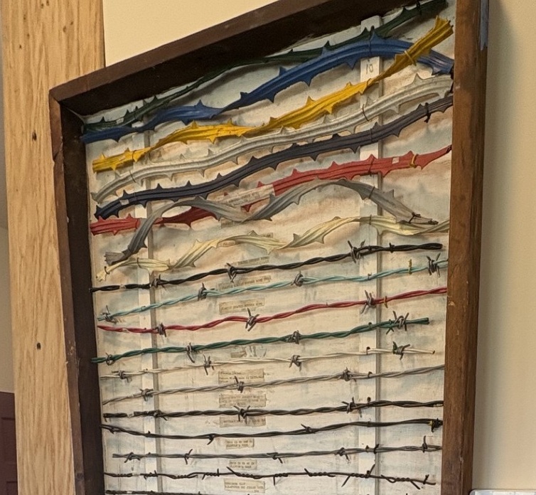
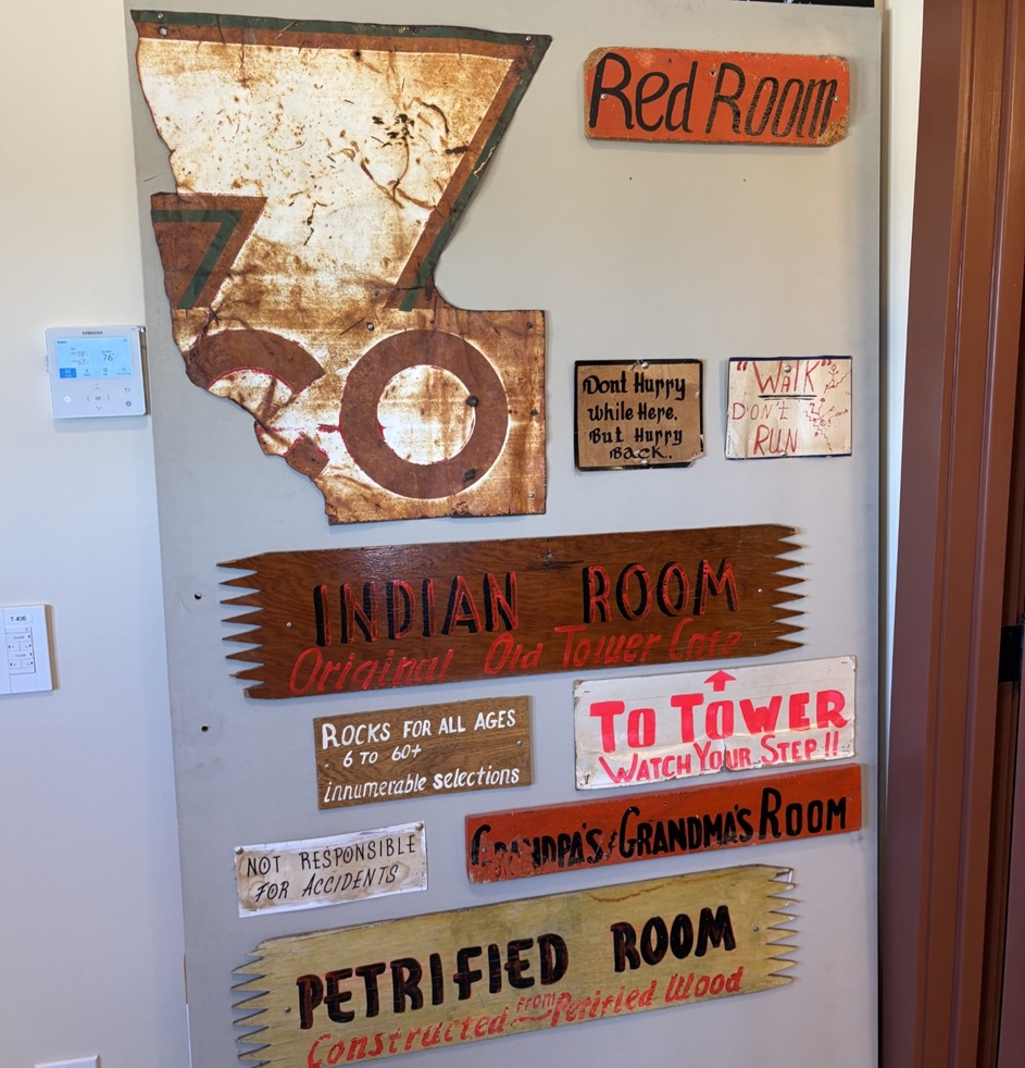
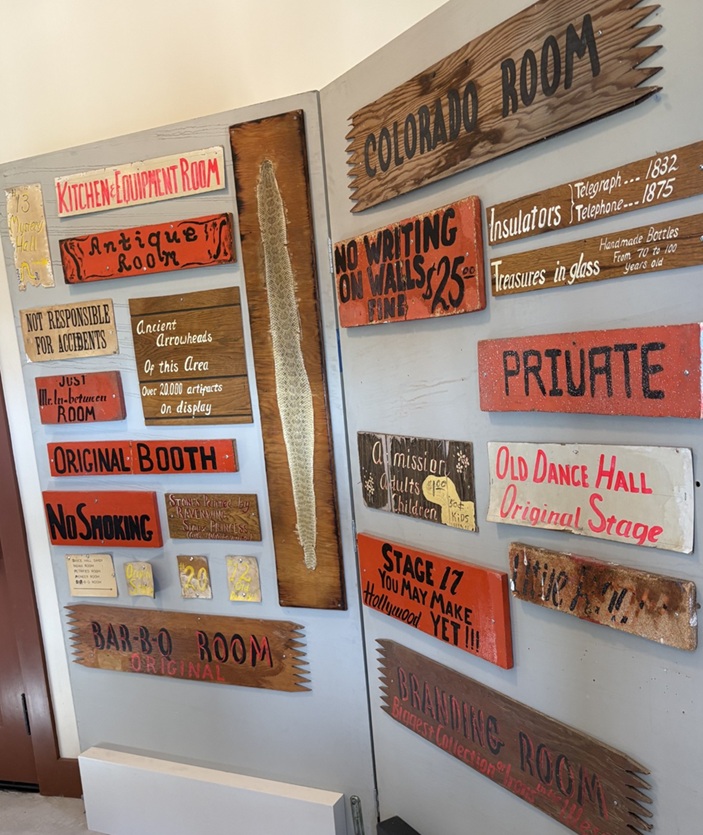
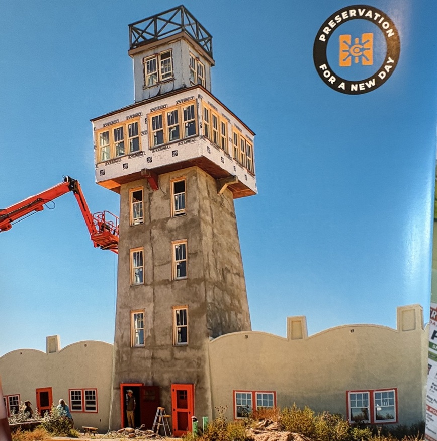
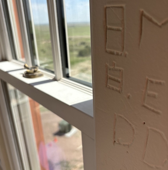
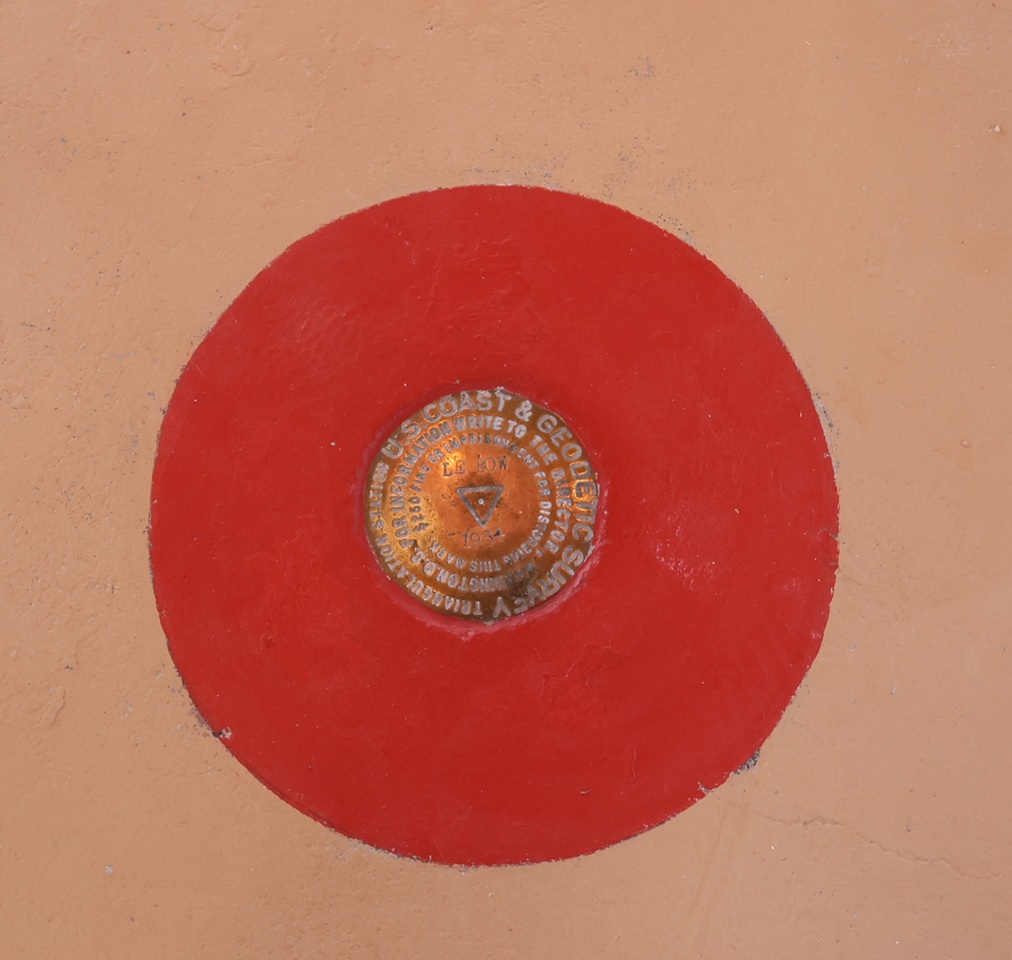
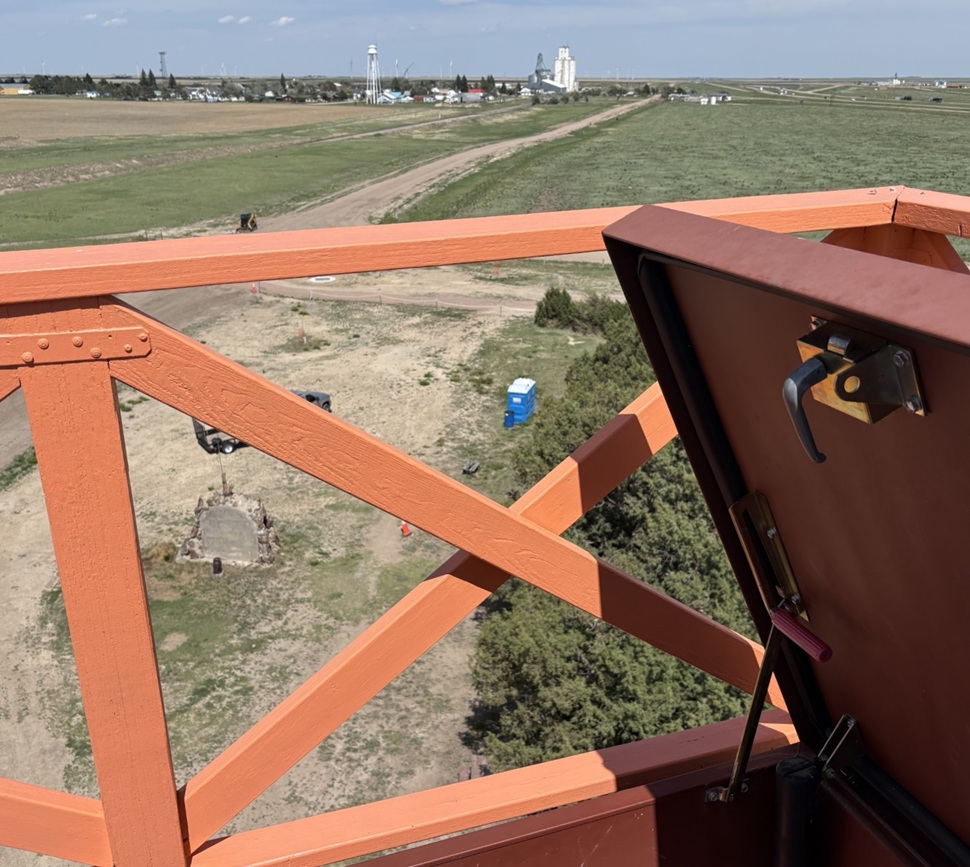
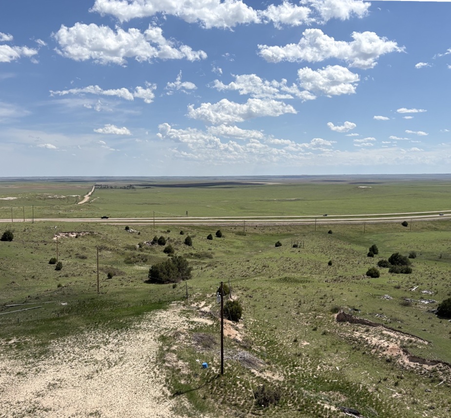
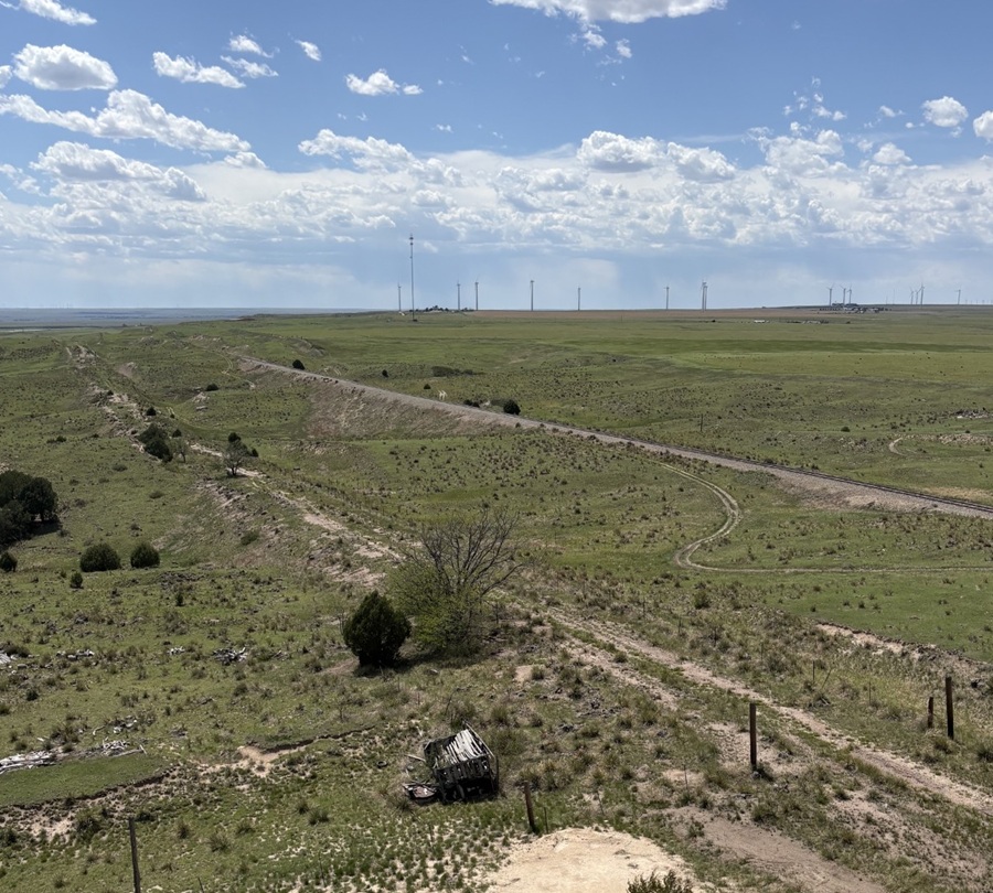
Much of Jerry’s museum collection was sold at public auction, so the two-headed calf and fossilized mammoth bones and most of the other items have found new homes all around the world (although word on the street is that there is an effort to retrieve some of the curiosities, but you didn’t hear that from me). One item that thankfully didn’t get spread to the four winds is this fine display of barbed wire, exhibited in the tower’s gift shop. Regular readers of this blog will know that I will spare no effort to post pictures of any worthy museum’s barbed wire exhibits and I’m rather unapologetic about it, so here you go.Fortunately, some of Jerry Chubbuck’s hand-painted museum signage, much of which identified the attraction’s many different rooms and warrens, was also withheld from the public auction and is now on display in the tower’s gift shop. I remember seeing some of these signs 40 years ago, and it was good to see them again.There were a lot of museum rooms (I want to say there were at least 20, but my memory may be faulty and it might have been more than that), and they all needed to be identified with signs. The sign at lower right, “Branding Room,” identified the room as containing the “Biggest Collection of Irons in the West.” I have no doubt that it was. Also of note: the signs announcing more than 20,000 “ancient arrowheads of this area” on display and “No Writing on Walls; Fine: $25.”This is a picture of a cover of one of History Colorado State Historical Fund’s annual reports, showing progress of the World’s Wonder View Tower restoration. The project, heavily financed by grants from the state’s historical fund but also with significant contributions from other donors from all around the state and local area, needed more than $3 million in funds for completion. See 6 States LLC and Friends of The Genoa Tower have some really exciting plans for the property, including its usage as an art gallery space and a venue for event functions. The property celebrated its grand reopening in early May of this year. From the standpoint of someone who visited it back in the day and then again this spring, it’s a very impressive transformation that has some great possibilities in front of it.Despite the threat of a $25 fine, many miscreants decided to leave graffiti on the tower’s walls as they ascended to the top. See 6 States LLC, in restoring the tower, made the right choice to leave the graffiti in situ while putting another coat of paint on the walls. This photo was taken from one of the tower’s staircases, looking southwest through a historic window.The United States Coast & Geodetic Survey placed this geodetic marker in the floor of one of the tower’s upper rooms in the 1930s, confirming the latitude, longitude, and, most importantly, the elevation of the World’s Wonder View Tower. Note the name “LeBow” (as in Myrtle) and the year, 1934, in the center of the disk. The USC&GS existed from 1807 until 1970, when it and several other government agencies became part of the National Oceanic and Atmospheric Administration (NOAA). People who hike a lot may have seen these markers on trails, used to compile accurate survey information with exact latitudinal, longitudinal, and elevation points on the surface of the Earth. This was the first one I’d seen that was about 50 feet off the surface of the Earth.The government surveyors used this wooden tripod, which they assembled in the tower room containing the geodetic marker, to precisely place the metal disk in the floor of the tower room in 1934. After the project’s completion, they attempted to take the tripod back down the tower’s stairs, only to find that the tripod’s legs were too wide to be transported down the narrow staircases. So, here it has stood for nearly a century, getting a new coat of paint every now and then.When I was a boy, the staircases in the tower, especially this final one leading to the viewing platform at the very top, could charitably be called “rickety.” See Six States LLC reinforced all of the staircases during the redevelopment, and the climb to the top and the viewing platform are rock-steady now. Happily, the group elected to keep the time-worn steps themselves; one wonders how many shoes have been on these steps in the last near-century. Those are Nancy’s shoes at the top of the photo; she and I had been at the top of the tower together a short time after we met when the Genoa Tower was still under the stewardship of Jerry Chubbuck, so she’s a seasoned veteran of the climb. Are you ready to discover what being at the top of the World’s Wonder View Tower looks like? Just follow Nancy!Taken from the top of the World’s Wonder View Tower, this viewpoint looking east-northeast shows the town of Genoa and then (“technically”) the states of Kansas and Nebraska beyond. Genoa’s water tower and grain elevator, both of which are predated by, and taller than, the World’s Wonder View Tower but you probably aren’t allowed to climb to the their respective tops, can be seen in center-right. You’d think that Genoa, Colorado, would be pronounced the same as the city in Italy (“JEN-oh-uh”). You’d be wrong: it’s pronounced “jen-OH-uh.” Now you know and can impress your friends with your newly acquired worldly knowledge, which, come to think of it, I probably should have shared before nearing the end of this posting.This perspective from the top of the World’s Wonder View Tower is looking directly south. On the other side of the cedar trees is Interstate 70, then about 20,000 square miles of Colorado farm- and ranchland, then (“technically”) New Mexico. It was a little hazy on the day of our visit, but the views were still really spectacular.This is a view from the top of the tower looking to the southeast. That’s again Interstate 70 near the horizon and (“technically”) Kansas beyond. Being 65 feet above the ground gives an interesting perspective to your surroundings, such as seeing some parts of the landscape under the darkness of cloud cover. The red roofs are the historic buildings of the World’s Wonder View Tower, where the café and overnight guest rooms, and later Jerry Chubbuck’s museum, were located. Just above them is the back side of the white-and-red “See 6 States” façade shown earlier. The white Ford F-350 Super Duty is Ol’ Blue, the Goddard’s six-wheeled towing unit. Just visible above the tree to the left of Ol’ Blue is a small travel trailer. That’s our first camping trailer, the predecessor to The Goddard, which we called “The Riglet” because bigger camping trailers and motor homes are sometimes called “rigs.” The Riglet is now owned by our friends Mary and Robert, whose company we enjoyed at the World’s Wonder View Tower and then they joined us in the Arriba campground in which we were staying for more fellowship.One last view from the top of the tower: this is looking northwest, so Denver is presumably somewhere on the horizon. There’s a radio tower on the horizon just left of center and most of the rest of the tall structures are wind turbines. The dependable winds available in eastern Colorado are quickly making the area an important location for renewable energy generation. The railroad bed and rails, still in use today, can be seen in the center of the picture, and just to the right of the tree in lower center is a dirt road that is the remnant of the old U.S. Highway 24 which, until the completion of Interstate 70 in the 1970s, brought people by the tens of thousands to the World’s Wonder View Tower. Goodbye until we see each other again, World’s Wonder View Tower! I look forward to seeing what your next hundred years will bring.
Located just seven miles south of Albuquerque, Valle de Oro National Wildlife Refuge (NWR) was established in 2014 as the first urban NWR in the American Southwest. One of nearly 600 national wildlife refuges in the United States, Valle de Oro is adjacent to Rio Grande Valley New Mexico State Park, which is next to the Rio Grande (there’s no “River” after the name because “rio grande” means “big river” in Spanish, so it’d be like writing “big river river”). Through the National Wildlife Refuge System, a number of different ecosystems, including wetlands, prairies, forests, and coastal areas, are protected from development in order to provide habitats in which wildlife and plants can thrive.
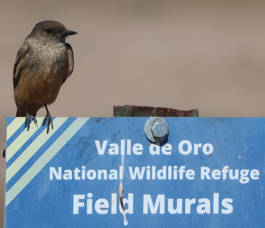
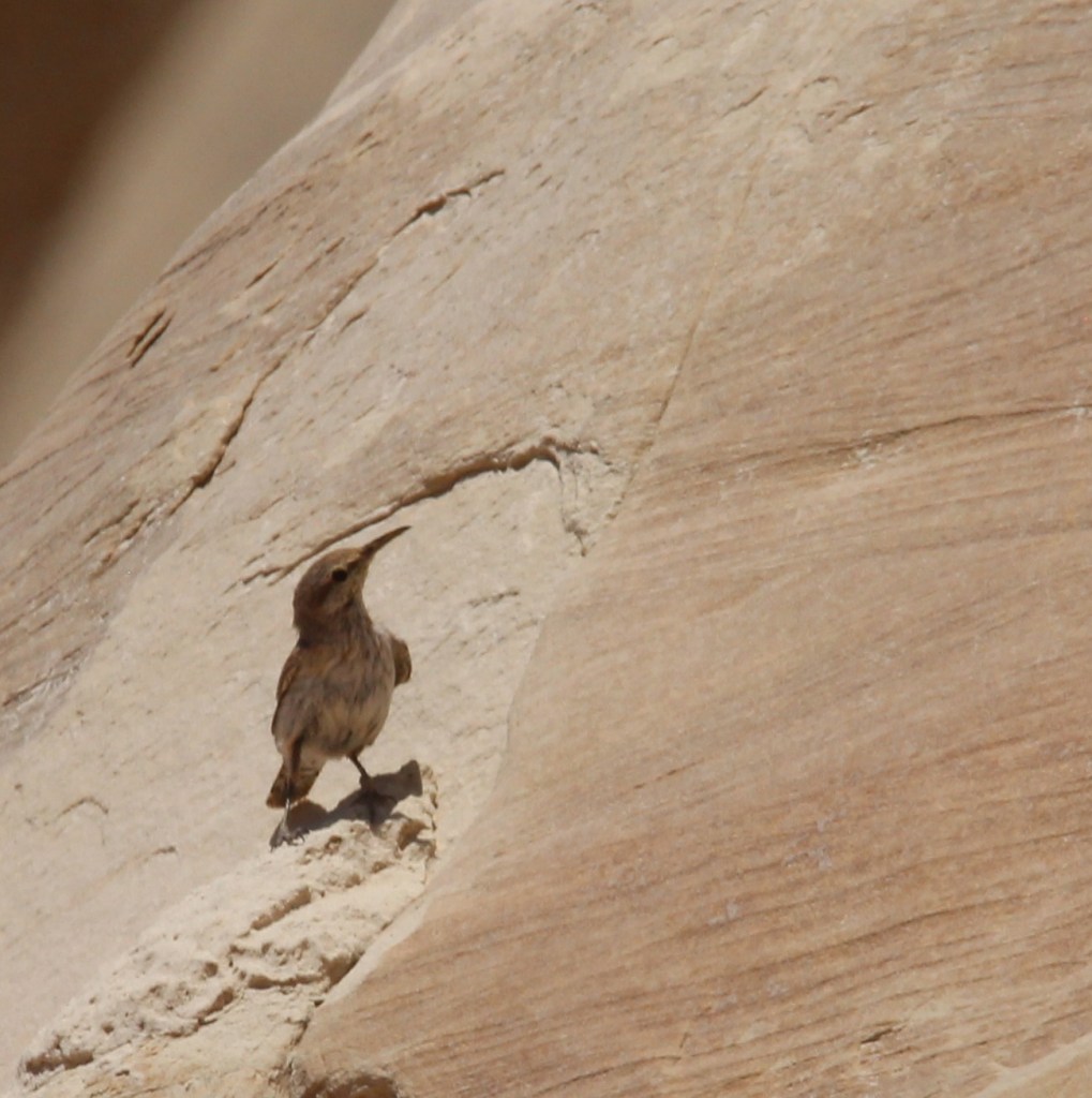
This Say’s phoebe welcomed us to the start of a hike at the refuge called the Valle de Oro Bosque Loop. “Bosque” (pr. boss-KAY) is Spanish for “forest,” and it refers to the many trees, mostly cottonwood, that line the banks of the Rio Grande just on the other side of the refuge’s western boundary.
In the case of Valle de Oro NWR, the refuge isn’t protecting undisturbed habitat that’s threatened by commercial development but rather restoring natural habitat from a formerly developed state.
This is near the trailhead of the Valle de Oro Bosque Loop. The Rio Grande doesn’t pass through Valle de Oro NWR, but rather on the western side of the refuge. You can probably tell, from the cottonwoods on the horizon, where the water from the river regularly reaches.
Because of the ongoing drought in the American Southwest, the Rio Grande can’t even realistically be called “big”; while we were in Albuquerque in May, the river was barely a trickle as it ran through the city. When not impounded and when historically normal moisture is available, the Rio Grande flows 1,896 miles from its headwaters in southwestern Colorado, through New Mexico, forms the southern border of Texas, and empties into the Gulf of Mexico. The Rio Grande is the fourth-longest river in the United States.
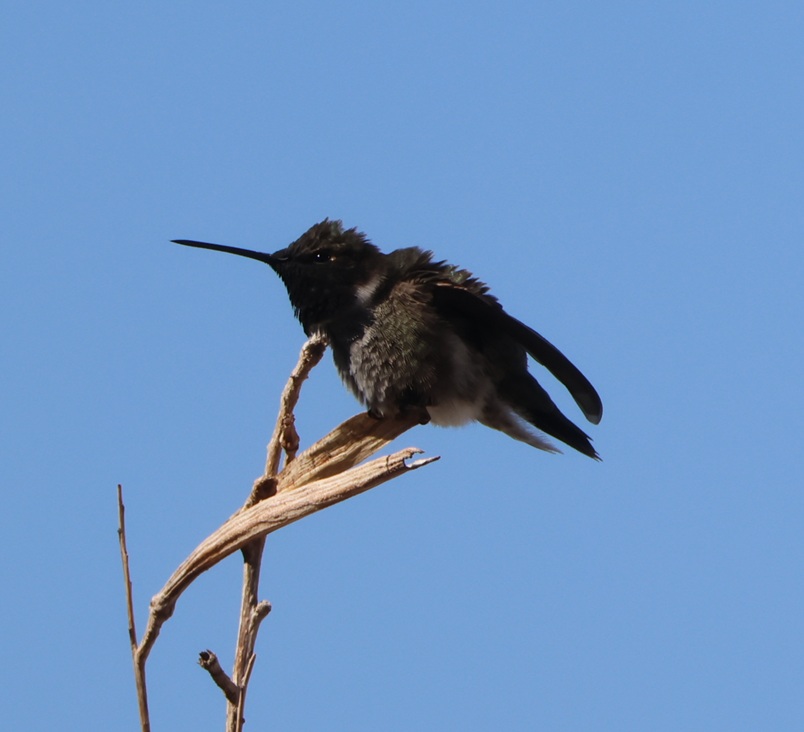
This black-chinned hummingbird (Archilochus alexandri) was making itself more comfortable on a perch just outside the front door of the refuge’s visitor center. The average heartrate of these little birds is 480 beats per minute, and in cold weather they may eat three times their body weight in flower nectar per day. They have body lengths of 3.5 inches (9 cm), weigh 0.1-0.2 ounces (2.3-4.6 g), and their wingspans measure 4.3 inches (11 cm). For comparison, a United States nickel minted in 1965 or later weighs 0.176 ounces (5 g). In good habitats, like along a river, a black-chinned hummingbird nest may be found every 100 yards (91 m) or so; their eggs are the size of coffee beans. Male black-chinned hummingbirds have a really vibrant swath of iridescent purple feathers on their chins, but those only appear when the sun hits them just right.
The 570-acre (just under one square mile) protected area now known as Valle de Oro NWR has a long and interesting history going back many centuries, and counts Pueblo Native Americans, Spanish conquistadors, and dairy and alfalfa farmers as those who have used its resources.
Valle de Oro NWR is among the ancestral and current lands of the Tiwa People, a Pueblo culture of Native Americans in what is now the Albuquerque area. Some of the Tiwa currently live in the Isleta and Sandia pueblos, two of New Mexico’s 19 Native American pueblos. The Pueblo culture initially developed between the years 700 and 1100, and particularly thrived between 1100 and 1300. Both Isleta and Sandia were established as pueblos in the 14th century; they were known by their Tiwa names until the Spanish arrived in the area in the late 15th century. “Isleta” and “sandia” are Spanish for “little island” and “watermelon,” respectively (more on “sandia” further down).
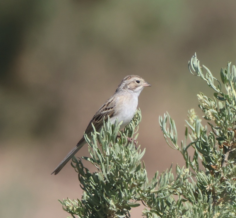
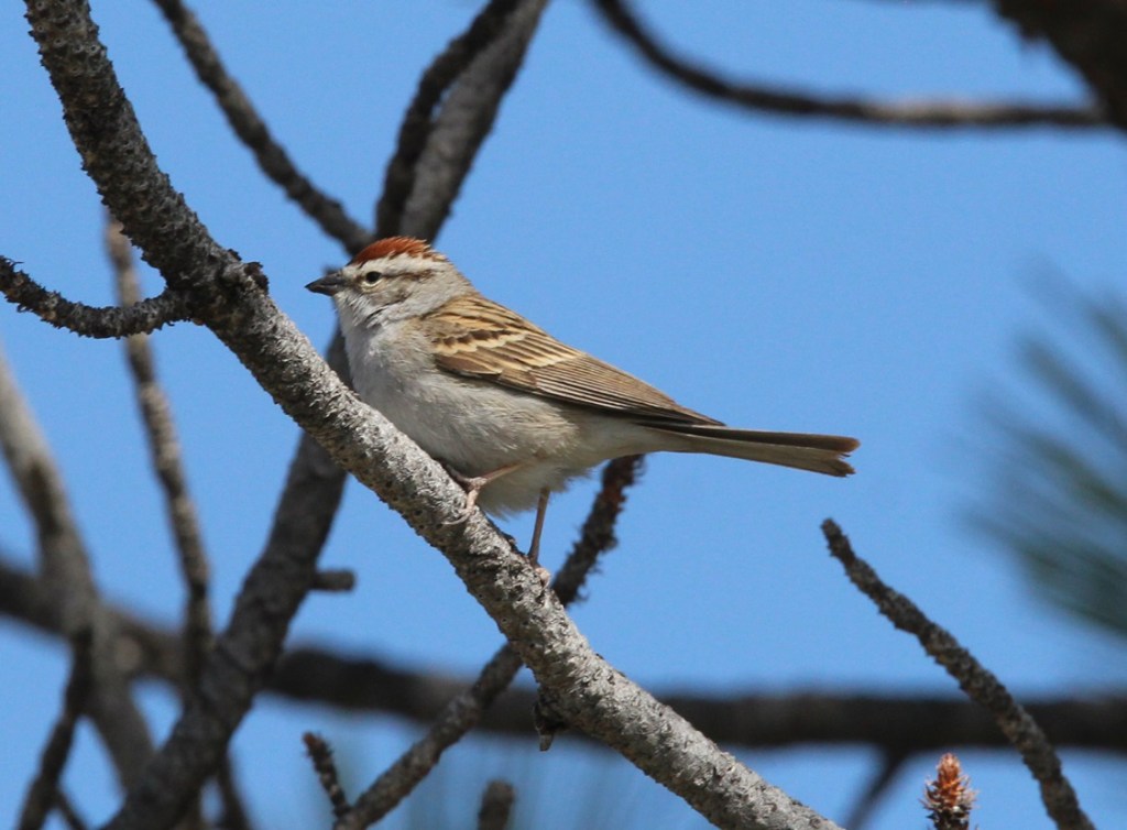
Nancy’s very good at spotting birds in the wild, and she pointed out a pair of these Brewer’s sparrows (Spizella breweri) that were perched at least 50 yards away on a sagebrush. Their size differs depending on their regional habitats, but in general Brewer’s sparrows are the smallest sparrows in North America with weights of 0.4-0.5 ounces (11-14 g). Because of a lack of defining coloration, markings, or other identification characteristics, these sparrows show why birding enthusiasts came up with the acronym of “LBB” for “little brown bird,” to serve as a temporary moniker of an individual bird until positive identification can be made.
The Spanish established a major road, El Camino Real de Tierra Adentro (“the royal road of the interior land”), that extended 1,590 miles (2,560 km) from Mexico City to just north of Santa Fe in present-day New Mexico. The road, one of four that connected Mexico City to the resources of the vast Spanish colony in America, was used from 1598 to 1882 to transport soldiers and trade goods. Much of El Camino Real still exists in the form of state highways and county roads (it passes right by one of our favorite restaurants in Las Cruces), and, back up near Albuquerque, it forms the eastern border of what is now Valle de Oro NWR.
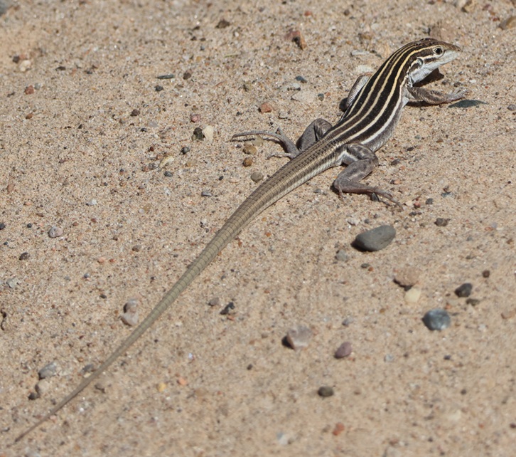
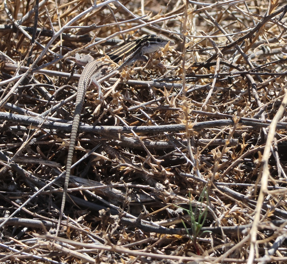
THIS IS A TALES OF THE GODDARD LIZARD ALERT. Desert grassland whiptail lizards (Aspidoscelis uniparens) live along the Rio Grande in New Mexico and in southern to central Arizona, as well as in northern Mexico. Their tails are longer than their bodies, which measure 2 3/4 to 5 1/4 inches (7.0-13.3 cm) long. They are easily identified by the six yellow stripes extending from the head and along the body. Desert grassland whiptails eat a variety of insects and other invertebrates, including ants, termites, beetles, butterflies, and grasshoppers.
Time passed, and, when Mexico gained its independence from Spain in 1821, Albuquerque changed from a New Spain outpost into a Mexican city. Albuquerque and the rest of the American Southwest became part of the United States in the mid-19th century and, in the 1930s, a family with a dairy in El Paso, Texas, expanded their operations to include a tract of land near Albuquerque. The family named the dairy “Valley Gold,” which you might, and correctly, infer (roughly) translates in Spanish to “valle de oro.” Following an increased demand for milk in the southwest after World War II, Valley Gold expanded its herd to 1,600 cows, making it one of the largest privately owned dairies in the country. The U.S. Department of Agriculture records that an average dairy cow in 1950 produced 5,300 pounds of milk each year (in 2025, an average dairy cow produced 24,400 pounds of milk annually; the industry has certainly gained some efficiencies). Anyway, dairies use a lot of water, so the Valley Gold operation developed substantial irrigation infrastructure using water from the nearby Rio Grande.
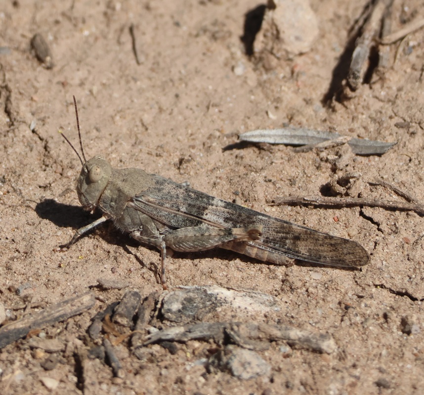
There were quite a few grasshoppers jumping about the trail as we walked. This is a pallid-winged grasshopper (Trimerotropis pallidipennis), a species common in the American Southwest. They grow to a length of 1 1/2 inches (37 mm), and their pale coloration makes for good camouflage in the dry riverbeds that they frequent.
Valley Gold ceased operations in the Albuquerque area in the late 1970s, and the property operated as an alfalfa farm (which also required a lot of water) for some time until the land was put up for sale and probable commercial development. A group of residents in the area formed Friends of Valle de Oro, a nonprofit organization that raised $9 million to buy the property and then partnered with the U.S. Fish & Wildlife Service to create the southwest’s first urban national wildlife refuge. What had been home to Pima People, part of the route from Mexico City to Santa Fe, then a dairy and alfalfa farm, was now ready to welcome back dozens of species of birds, mammals, and other wildlife to an area protected from commercial development.
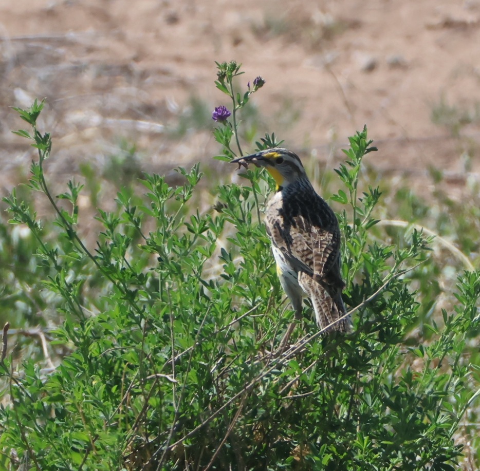
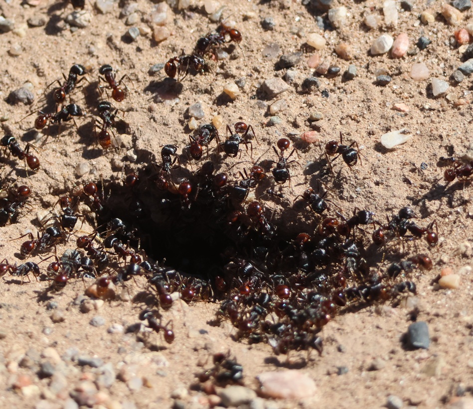
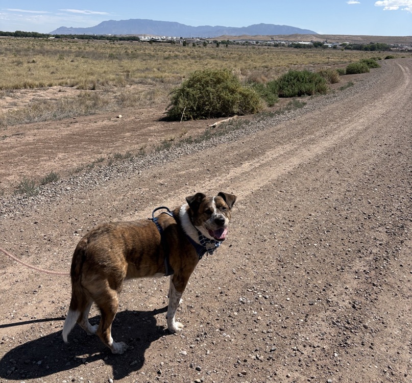
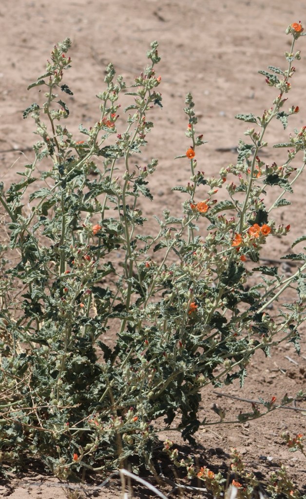
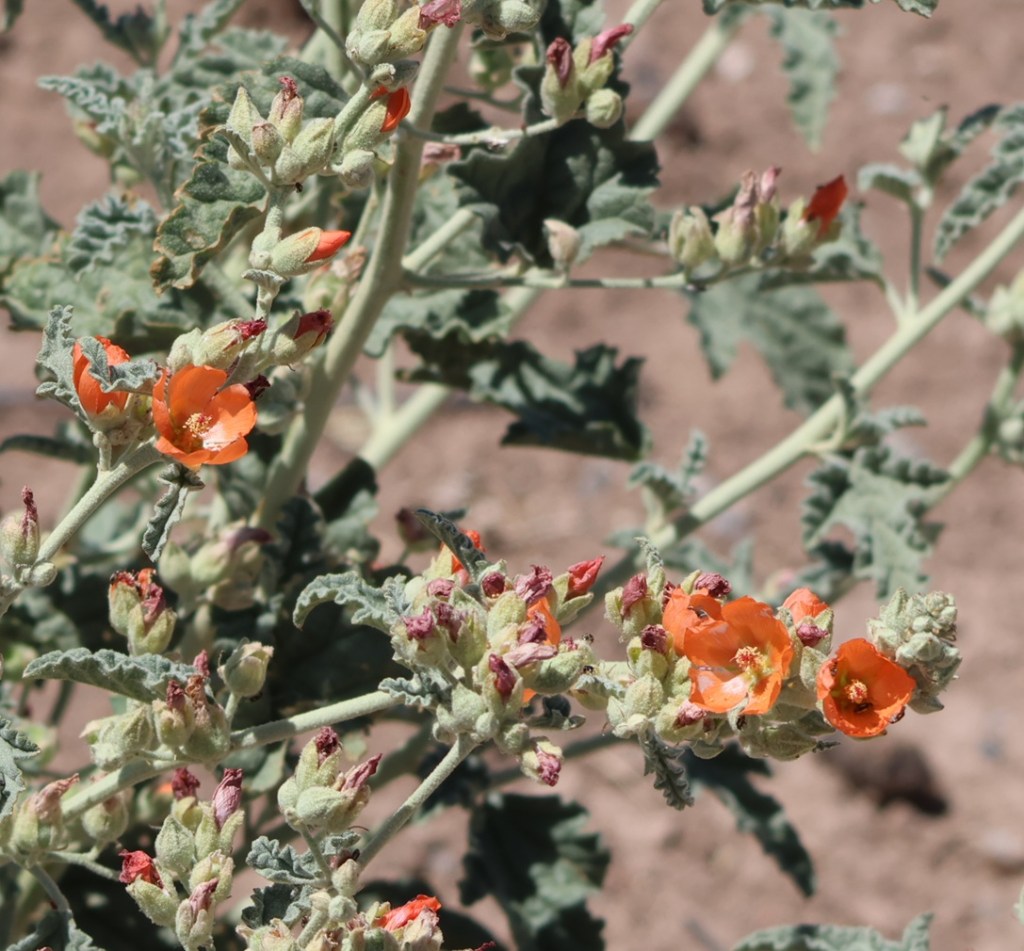
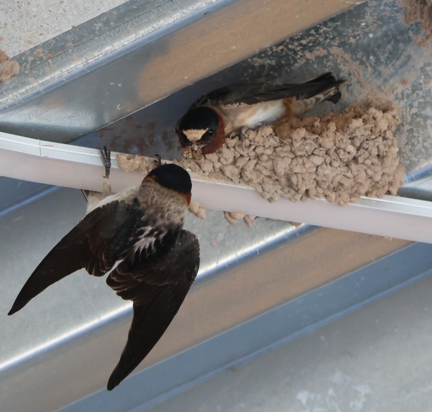
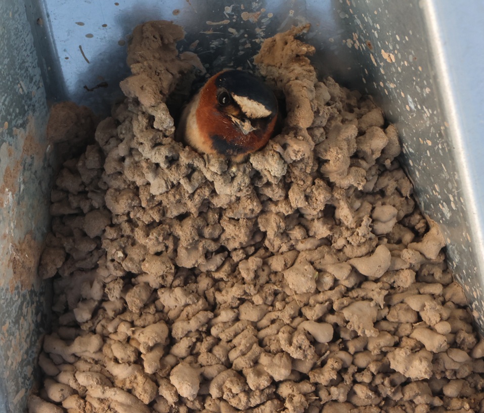
Here’s a photo of another grasshopper; this one finds itself in the unfortunate position of being in the beak of a western meadowlark (Sturnella neglecta). No less a naturalist than John James Audubon gave this bird its scientific name: “sturnella” means “starling-like,” and “neglecta” refers to Audubon’s belief that this species was overlooked by 19th-century ornitholgists. The plant on which the meadowlark is perched points to the refuge’s past: it’s alfalfa, which, due to its high protein content, comprises up to 50 percent of a dairy cow’s diet. Although the irrigation systems that served the dairy and alfalfa farms that once occupied this land are long out of use (the canals are filled with blown dirt and sand), some alfalfa plants still found enough water to thrive and bloom.THIS IS ANOTHER TALES OF THE GODDARD LIZARD ALERT and it’s another desert grassland whiptail. They’re well-camouflaged in dry desert brush like this. Albuquerque is at the northern edge of the Chihuahuan Desert, and here was a reminder that deserts have lots of sharp things like cactus thorns and ant mandibles. At one point on the trail, we stopped because Nancy had seen a bird drop from a low branch onto the ground and was attempting to spot it. I told her not to back up. lest she step into this. It’s a colony of desert harvester ants (Pogonomyrmex rugosus), which have powerful jaws and very painful venomous bites. These ants use pheromones to create invisible trails that enable other ants to follow to the colony, bringing with them plant seeds and dead insects. A few minutes before, I noticed a couple of small leaves moving on the trail in the same direction we were walking even though there wasn’t a breeze. The leaves were being carried by two harvester ants, presumably from this colony. We left the colony and continued on the trail without incident.Here’s Gunther, who enjoyed the walk with us, and here’s what much of the terrain of the Valley de Oro Bosque Loop looks like, at least away from the parts connected to the Rio Grande. Because it was used for so many decades as a dairy and later an alfalfa farm, there aren’t as many native plants as there are in other parts of the desert around Albuquerque – when water stopped being diverted from the Rio Grande, the land essentially dried up. Volunteers and NWR staff are hard at work changing that, with plantings of trees and other native plants. The buildings just this side of the mountains are in Albuquerque, and the mountains themselves are the Sandias. They rise to a top elevation of 10,678 feet (3,255 m) and are New Mexico’s most-visited mountain range. Spanish explorers gave the mountain range the name “sandia” because they seem to glow pinkish-red, like a watermelon, during Albuquerque sunsets.The mission of the National Wildlife Refuge System is “To administer a national network of lands and waters for the conservation, management, and where appropriate, restoration of fish, wildlife, and plant resources and their habitats within the United States for the benefit of the present and future generations of Americans.” Here’s an example of the plant resources: desert globemallow. Its coral-colored flowers are an extremely familiar sight to anyone in the desert southwest. I remember on a drive to the north rim of the Grand Canyon in north-central Arizona a couple of years ago, we saw millions (maybe an exaggeration, maybe not).Even though it’s very, very common, I always like seeing desert globemallow (Sphaeralcea ambigua) while we’re in the southwestern United States. Its blooms are just gorgeous, and they support the larval stages of at least five different pollinating buttterflies. The plants grow to a height of 3 feet (just under a meter), with a spread of 2-3 feet (0.6-0.9 meters). I’m writing this blog posting from our campsite in Santa Fe, New Mexico, a few days after our visit to Valle de Oro National Wildlife Refuge, and there are (very short) desert globemallow plants growing outside the Goddard.These are cliff swallows (Petrochelidon pyrrhonota) working together to build their mud nest under the roof of the refuge’s visitor center. Nancy and I estimated that there were several hundred of these swallows flitting about the visitor center and constructing their nests for the spring. These birds eat all kinds of flying insects and they are themselves incredibly skilled aerialists; I took about 50 pictures of swallows in flight at Valle de Oro and none of them turned out well because the birds were flying and turning so quickly. A staff person told Nancy that swallows lived in the huge dairy barn that used to be at the refuge, and they’ve adapted to using the new visitor center for nesting.This nest appears to be nearly complete. Each nest is built from 900 to 1,200 mud pellets, with walls that are about 1/2-inch thick. A cliff swallow clutch can include between one and six eggs, and a female swallow may lay one or two clutches during the breeding season. Cliff swallows nest near bodies of water, which provide mud for nests as well as insect habitat. Most cliff swallow colonies contain between 200 and 1,000 nests, although there’s a colony in Nebraska with 3,700 nests. It strains the mind to think about how many flying insects are needed to feed all of those birds every day. Here’s another western meadowlark that was perched about 50 yards from the refuge’s parking lot, with a link to an audio file of a western meadowlark’s call:
Whenever I hear that wonderful call, I’m reminded of meadowlarks that I used to listen to at the Denver-area office of one of my previous jobs. The parcel adjacent to the office was less than an acre but still unbroken prairieland, and it attracted quite a lot of wildlife including western meadowlarks. I enjoyed listening to them in the spring and summer months from the parking lot of my office, until construction began on that lot and it became another parking lot and commercial building. I remember being frustrated at the meadowlarks losing their habitat, and I also remember later realizing that the parking lot and building of my office was once wildlife habitat as well.
That’s the primary reason that the National Wildlife Refuge System exists: to protect wildlife habitats from development, or, in the case of Valle de Oro National Wildlife Refuge, to return commercially developed properties back into their native habitats. The Tiwa culture, the original inhabitants of this area in what is now central New Mexico, continue to play a major role in how Valle de Oro National Wildlife Refuge is managed and protected. I’m happy that’s the case.
Homolovi State Park, near Winslow, Arizona April 16, 2025
We’re camping for two weeks in Homolovi State Park, just a couple miles east of the town of Winslow, Arizona (pop. 9,005; perhaps you’ve heard of it – one of its street corners is mentioned in the Eagles’ first major hit from 1972, “Take It Easy”). This is our third time staying here in three years – we really enjoy it. After spending five months wintering in Las Vegas, Nevada, and then a couple of campgrounds on Interstate 40 in Arizona, we’re appreciating the quiet environment and dark skies of this state park (not that we didn’t have a good time in Las Vegas; in fact, we’ve reservations to be back there beginning this November).
The main feature of this state park is a cluster of four major ancient Native American villages, several miles apart and all built and occupied around the years 1290-1400. The villages were then abandoned, but it’s generally understood that the people who lived here eventually became what is now the Hopi nation – one of the tribe’s reservations is about 60 miles north of present-day Homolovi State Park. The four villages are designated Homol’ovi I-IV; the name of the state park doesn’t include the apostrophe of the village names. “Homol’ovi,” in Hopi, translates to “place of the little hills,” and the Hopi also refer to the city of Winslow as “Homol’ovi.”
The Hopi call the people who lived here – most likely their ancestors – the Hisatsinom, which means “the people of long ago.” During the period in which the Hisatsinom lived in this region, they built and occupied four or five large villages – some comprising hundreds of rooms – using rocks gathered from the ground.
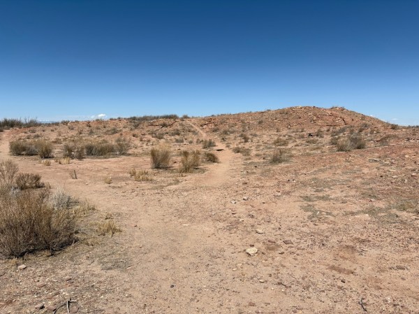
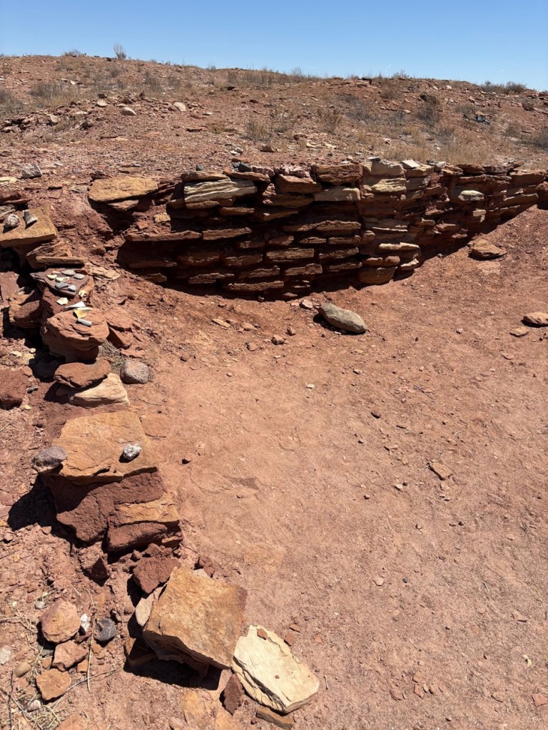
The Little Colorado River, a watercourse that drains the Painted Desert area of northeastern Arizona, flows through Homolovi State Park. I took this photo while Nancy and I were driving to Winslow; the perspective is looking north from a bridge on the former U.S. Route 66 (and now Arizona State Highway 87). The trucks and trailers just on this side of the horizon are on Interstate 40. The Little Colorado River’s headwaters are in the mid-eastern region of Arizona, very near the state’s border with New Mexico. It then flows almost 340 miles in a northwestern direction until it empties into the Colorado River in the Grand Canyon. The river flows from its headwaters all the way to the Grand Canyon only during periods of flash flooding or heavy snowmelt; much of the year it’s a braided and puddled wash. I took this photo the day after the area got some appreciable rain and snow, and the water level rose only marginally. The occasional flash flooding of the Little Colorado River, which swept away crops and structures, is probably why the Homol’ovi sites were abandoned in favor of the area further to the north and which the Hopi call home today.This is the site of a major native American village, known now as Homol’ovi I, that was last occupied about 600 years ago. At its peak, it contained about 1,100 different rooms constructed of rocks. Some of the rooms included three stories. Over the ensuing six centuries, a lot has happened to destroy these unoccupied villages. Dependable northern Arizona winds have covered the village with dirt and sand, but some structures, such as the one on the mound at the right, can still be discerned. Many of the rocks in the structures were taken by members of a nearby Mormon community in the late 1800s for use in their own buildings, and vandals have also destroyed the buildings and looted the pottery.
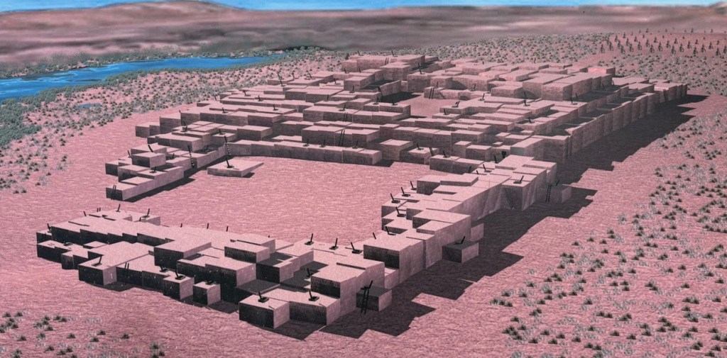
Take a look at the tall plants on the horizon at far left: directly to the right of them, you’ll see some white splotches (not the clouds, which are further to the right; the smaller white splotches of which I write are immediately to the right of the tall plants). Those are the San Francisco Peaks, still snow-covered in mid-April. The town of Flagstaff, Arizona, is at their feet. Those mountains are about 65 miles west of Homolovi State Park.I took a picture of this image, an artist’s depiction of what Homol’ovi I looked like at its peak, at an information kiosk near the site of the former village. That’s the Little Colorado River in top right. The original image gives credit to Douglas Gann of the Center for Desert Archaeology.
From about 1290 to 1360, it’s believed that Homol’ovi I grew from a village of 200 rooms to more than 700. Around the year 1360, the village now known as Homol’ovi II was established about 3 miles, or 5 kilometers, north of Homol’ovi I; that second village quickly became the biggest one in the cluster at 1,200 rooms. Homol’ovi I, however, benefited from the second village’s success, and grew to a maximum of 1,100 rooms.
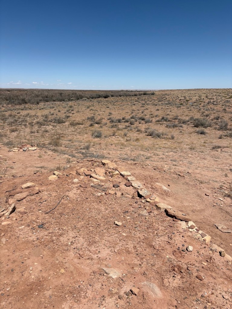
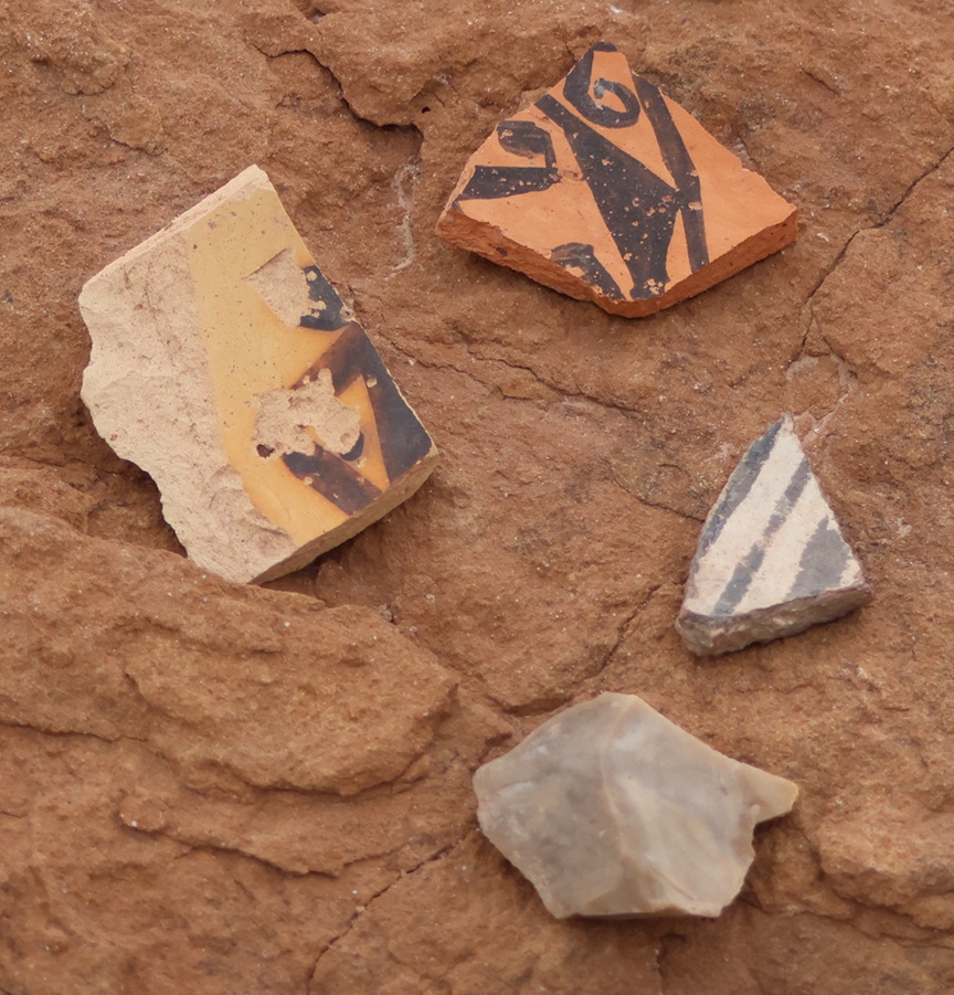
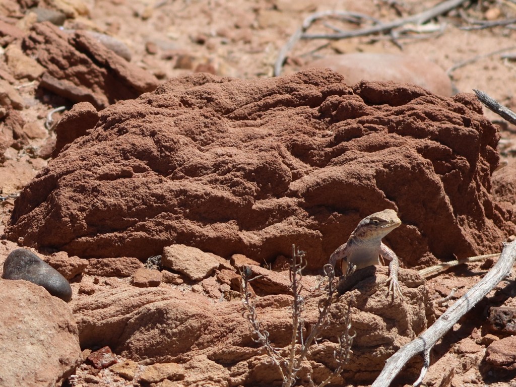
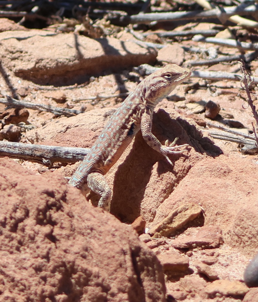
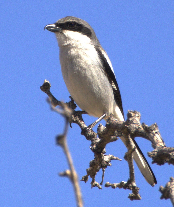
This photograph was taken from the top of the hill shown in the previous photo, still looking to the northwest. The rocks in a line are the former wall of a room. The trees near the horizon are on the east bank of the Little Colorado River; it was that river’s occasional flash flooding that likely led to the abandonment of Homol’ovi I and the other villages 600 years ago.This is a small grouping of pottery shards and what appears to be a hand-shaped rock, taken from the ground at Homol’ovi I and placed on a larger rock. The pieces of pottery are roughly the size of an American half-dollar. There are thousands of shards like these at the site, and most of them are on larger rocks like this. Archeologists and conservationists prefer that people don’t do this; instead, simply leave the shards on the ground.This is the largest exposed wall still standing at Homol’ovi I, and it’s been almost entirely rebuilt by archeologists. Note the small collections of pottery shards on some of the rocks at left: don’t do that.THIS IS A TALES OF THE GODDARD LIZARD ALERT. This little guy (and he is a guy, and I’ll tell you why I know shortly) caught my eye as he scampered across the rocks and sand of Homol’ovi I. He is a side-blotched lizard, a genus (Uta) of which there are now seven species, and he and I were to have kind of a neat interaction. This photo of my new reptile pal shows why the genus is called side-blotched lizard – observe the dark mark (or, in scientific terminology, “blotch”) on its side just behind its front leg. The turquoise-blue dots on the back are also a defining characteristic of the genus. These lizards grow to a length of about six inches, including the tail. Their diet includes insects, spiders, and other arthropods such as the occasional scorpion. They are themselves predated upon by larger lizards and roadrunners.In an attempt to give the reptile some space, I continued walking down the path through Homol’ovi I – but the beast pursued me. Observe the very pretty light-blue dots on its back. I was about six feet from the lizard when I took this photo (using a 400mm telephoto lens).Here’s a cropped version of the previous photo. Behold those beautiful blue dots as well as some detail of its fearsome front claws. After I took the photo, the lizard continued to approach me: in fact, it got to about six inches from my left foot – and then it scampered away. Turns out, that’s a common behavioral trait of male side-blotched lizards. The scientists don’t know if the behavior is intended to scare away possible intruders from its mate, or to defend its territory. At any rate, I got the hint and moved along (even though my course on the path took me in the same general direction of the lizard, who at that point was many yards away). I later described my interaction with the side-blotched lizard to Nancy, who did not at all appreciate when I poked her under her armpit to show her where the blotch on the lizard’s side was. We also shared the same belief that she would have absolutely and completely freaked out if the lizard had gotten to within six inches of her left foot.More wildlife: I always like to include some bird photos in these postings, so here are a couple of images I took in our campground at Homolovi State Park. This is a black-throated sparrow (Amphispiza bilineata), a species found in the southwestern United States and much of Mexico. They are absolutely beautiful little birds. I’ve seen them only here at Homolovi State Park and at Tuzigoot National Monument, further west in Arizona.This is a loggerhead shrike (Lanius ludovicianus), on a tree just a few feet from the Goddard’s campsite. I remember reading about shrikes when I was young, but I didn’t see one in the wild until a couple of years ago at McDowell Mountain Regional Park east of Phoenix, Arizona. I also saw some over this past winter at Clark County Wetlands Park, very close to the campground where we spent the winter near Las Vegas. Loggerhead shrikes are found nearly all over the United States.
We’re planning to join a ranger-led tour of Homol’ovi II, which has been partially excavated and reconstructed, on Saturday, April 26. I’ll write and post photographs from that experience afterwards. We were on the same tour a couple of years ago, but, because of our travels and opportunities to see ancient Native American sites in the southwestern United States since then, we have a better perspective of what we’ll see.
September 28, 2024 – Near Pagosa Springs, Colorado
At the entrance to Chimney Rock National Monument, one can see Chimney Rock (center horizon), Companion Rock (to the left of Chimney Rock), and the mesa on which an ancient Puebloan great house still stands (at far left).
The scientific pursuits of geology, archeology, and astronomy combine in a number of interesting ways at Chimney Rock National Monument, located about 20 miles of Pagosa Springs in southwestern Colorado. In late September 2024, the Goddard was parked for a couple of weeks in Pagosa Springs, allowing us to enjoy the spectacular fall colors of aspen trees as well as a visit to Chimney Rock National Monument. We joined a geology-focused tour of the monument led by a volunteer guide, a former geologist in the oil and gas industry. In addition to learning about the rock features of the monument, we also learned about the history of the human habitation of Chimney Rock and visited the highest-in-elevation ancient Pueblo in the American Southwest, the Great House.
I took this photo from the road entrance to Chimney Rock National Monument using a telephoto lens. For perspective, Chimney Rock on the right rises more than 300 feet above the dark gray shale layer below it.
Between the years 925 and 1125, more than 2,000 Pueblo Native Americans lived in the Chimney Rock region and, although no more than about 250 people called it home at one time, they made it a substantial settlement for two centuries. The inhabitants built a number of stone and timber structures that are still standing today, and they traded goods with other Pueblo communities up to 150 miles away. Today, archaeologists know of 200 ancient structures collected within eight distinct villages at Chimney Rock.
Initial archeological investigations began in the 1920s by J.A. Jeançon, a Smithsonian Institution-trained archeologist working on behalf of the Colorado Historical Society, and his assistant, Frank Roberts; they and their crew surveyed and mapped dozens of structures and found thousands of artifacts.
Today, the U.S. Forest Service, which manages Chimney Rock National Monument, is leaving many archeological sites undisturbed out of respect for existing Puebloan and other Native American cultures, and with the understanding that less-invasive archeological techniques may be developed in the future. More than two dozen Native American tribes have an affiliation with Chimney Rock.
The monument, surrounded by the Southern Ute Indian Reservation, is closed to the general public each year from September 30 to May 15. The closure allows Native Americans to access the site for private ceremonial purposes, and the Chimney Rock area is also a major thoroughfare for elk migration.
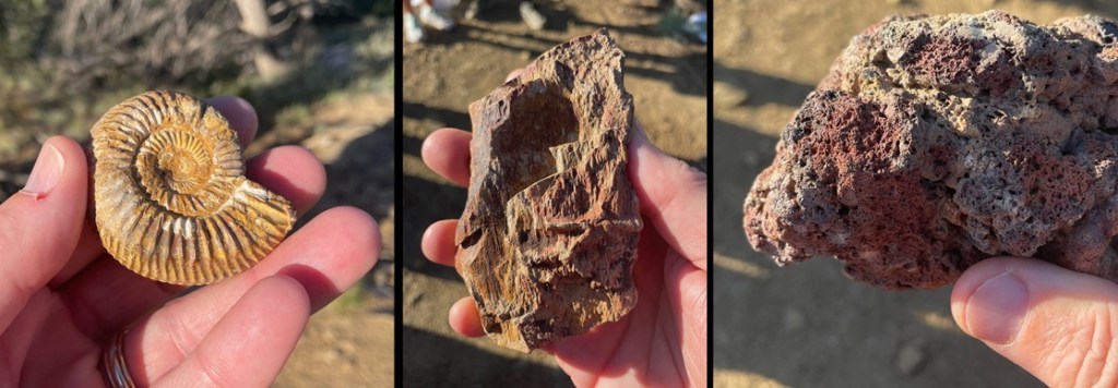
Geology! These three rocks, all of which were collected earlier at Chimney Rock by the volunteer geologist conducting our tour, tell a really interesting part of the story of the area. The ammonite fossil at far left shows that Chimney Rock, which today gets about 14 inches of precipitation annually, was once covered by an inland sea. Ammonites were incredibly diverse and numerous aquatic cephalopods (related to modern squid and octopi) that flourished for hundreds of millions of years until the Earth’s collision with an asteroid 65 million years ago. The petrified wood in the center indicates that large trees used to grow on shorelines left when the land rose and the sea receded. Finally, the basalt at right was ejected from an erupting volcano in the area. (Yes, I know the ammonite photo also demonstrates that I was, at the time, in gruesomely desperate need of my semi-annual mani-pedi.)
The true importance of Chimney Rock lies, of course, in its ties to ancient and current-day Native Americans. But from a geologic perspective, the story of Chimney Rock begins, seemingly as do so many on this website, with a great inland sea. One hundred million years ago, much of present-day North America was under a shallow but vast sea that connected the Gulf of Mexico to the Arctic Ocean. At its largest size, the Western Interior Seaway stretched from today’s Rocky Mountains in the west to the Appalachian range in the east. At its deepest points, it was only about 3,000 feet from the waves on top to the sea bottom – very shallow for a sea. The size of the sea varied widely over the course of its 34 million years of existence; it finally drained away for good about the time of the end of the Cretaceous Period, or 65 million years ago when dinosaurs ceased to rule the earth.
While it was relatively shallow, the Western Interior Seaway’s 3,000 feet of water depth carried a lot of compression capability. Clay at the bottom of the sea, as well as dead plants and animals, accumulated over the eons to build a 1,000-feet-thick layer of mud. That layer would solidify, over millions of years of water weight pressing upon it, into a dark gray layer of rock called Lewis Shale. When the western part of the American continent began to rise, the waters of the inland sea drained away to leave shorelines of sand and tidal flats. Dry periods alternated with years upon years of wetter conditions, leaving layers of coal and fossilized animal skeletons.
About 40 million years ago – 26 million years after an asteroid impact killed all of the non-flying dinosaurs as well as a goodly amount of other life on Earth – volcanoes began erupting in the Four Corners area of Colorado, Utah, New Mexico, and Arizona. This activity built the Colorado Plateau, a huge high-desert expanse of the southwestern United States covering 130,000 square miles of those four states, roughly centered in the Four Corners area.
The erosional forces of wind and water began to have their way with the soil covering today’s Companion Rock and Chimney Rock, and then glaciers from the last Ice Age of 4 million years ago carved deeply into the former mud of the inland seafloor, now compressed into shale. Finally, the glaciers melted and the resulting floodwaters exposed sandstone – formerly the beaches of the receding inland sea from tens of millions of years earlier but compressed into a rocky layer – and eroded away nearly all of that sandstone layer with the exception of Companion Rock and Chimney Rock. The scientists believe that the two sandstone features have been exposed for about 25,000 years, protected by what was probably the thickest and hardest layer of sand during the time of the Western Interior Seaway and is now a layer of sandstone more resistant to erosion than other rocks had been. However, they too, with the relentless work of water and wind, will gradually fall to the valley below.
This view, looking east on a hazy late-September morning, shows the dark-gray Lewis Shale layer below the light-brown Pictured Cliffs Sandstone layer, of which Companion Rock and Chimney Rock are the tallest remnants. This valley was carved by glaciers and the flooding of the melted glaciers as well as the Piedra River. To the immediate left of the two natural rock towers is the Great House, built by ancient Puebloans . The San Juan mountains, volcanic in origin, are on the far horizon.This is the trail leading to the monument’s Great House, one of the square exterior corners of which can be seen at the top of the photo. This is the same trail that was used by the ancient Puebloans to make their way from the valley floor to the Great House. The trail is situated on a relatively thin ridge of sandstone. Everything brought to the Great House – building materials, foodstuffs, water – was carried by the ancient Puebloans, by hand, up this trail.These sandstone rocks are on the trail to the monument’s Great House. Our geologist guide noted that the natural fracturing of the sandstone made selection and collection of the rocks much easier for the Puebloan builders of the structures in the monument. Note also the brownish markings in the rocks: they’re about 6-8 inches long, and are the fossilized burrows of a prehistoric crustacean that lived in the sand of the inland sea that once inundated much of North America. The animals dug these burrows into the existing shoreline sand, and the holes gradually filled with clay and mud containing iron to leave behind the brown fossils seen on the trail today.Archeology! This south-facing exterior wall of the Great House has an interesting story. Most of the rocks comprising the Great House and other structures were replaced, in place, over the last century by archeologists and during a major project in the 1970s involving Native Americans. The structures had simply fallen victim to the forces of erosion over the course of 10 centuries of non-occupancy. However, the modern-day wooden shelf in the center of this photo is protecting part of a stone wall that was laid by Puebloan hands a thousand years ago and managed to stay intact. Note the different size and color of the rocks surrounding the original work.The rock formations are still quite a good distance from the Great House; Chimney Rock itself is 315 feet tall. Scientific analysis of some of the wood beams still left at the Great House shows that construction began in the year AD 1076 and then expanded in AD 1093. Those particular years would prove to be significant in discovering why Great House was built where it was.This picture was taken looking southwest from atop one of the Great House’s walls. Many of the rocks in the walls have been replaced over the years, but some parts of the walls feature the original masonry and stonework. It’s estimated that the Great House was built using up to six million stones, all of which were hand-selected, hand-shaped, and hand-carried to this site. All of these walls were once taller, and roofs covered the buildings. On the far horizon, in the center of the photo and between the left and right hillsides, lies New Mexico. Visitors from Chaco Canyon, 90 miles away, would approach the Chimney Rock villages through that low valley. Similarities between the architectural styles of the buildings at Chaco Canyon and Chimney Rock, as well as those of cultural artifacts, such as pottery designs, stone tools, and projectile points, demonstrate that the two communities shared many ideas over the two centuries of Chimney Rock’s existence. Similar artifacts show that the residents of Chimney Rock may have traded with still other Native Americans living up to 150 miles away.
Jeançon began his excavation of the Great House Pueblo in 1921. He noted that some of the walls were still 14 feet tall. The building contained at least 35 rooms and two kivas, the round structures believed to be the center of the ancient Puebloans’ spiritual and perhaps social lives. An archeologist has estimated that to build a structure of this size and complexity, in addition to the 6 million rocks, the builders would have needed 5,000 log beams, 25,000 tons of water, and 25,000 tons of dirt to make an adobe mortar. All of these materials would have had to have been carried up the steep trail by hand.
Considering all of the labor needed to build Great House and the many other structures, one is left with the question of why the residents stayed here for only two centuries. There are three prevailing hypotheses for the ancient Puebloans’ departure: it’s possible that the area was depleted of food and other resources; societal changes or perhaps warfare made it in the residents’ best interests to leave; or the community, representative of other Puebloan cultures of the time, simply decided that it was time to find a new home. Whatever the reason for their departure, it’s believed that the residents of Chimney Rock, along with many other ancient Puebloan communities, moved south into present-day New Mexico and Arizona; their descendants can be found today among the members of the Navajo, Hopi, Zuni, and other Native American tribes.
While at the Great House, I took a picture of Companion and Chimney rocks with my telephoto lens. The distance from the Great House to the rock formations makes them look smaller than they actually are; as I noted earlier, Chimney Rock, the structure furthest away, is taller than a football field is long. The top of Companion Rock is a nesting area for peregrine falcons. Because of their spiritual significance to Native Americans and to protect the birds’ nests, both rock formations are off-limits to hikers and rock climbers.
That covers some of the geology and archeology at Chimney Rock National Monument; let’s move on to the skies above. Nancy and I learned a new word the day we visited the monument: archeoastronomy. This vowel-heavy construction refers to the study of the ways in which ancient cultures studied the skies and how they used that information to guide many of their day-to-day and seasonal decisions, including when to plant crops and conduct spiritual ceremonies. Around the world, very old cultural sites, like Stonehenge in England and hundreds of temples in Egypt, show that ancient peoples were keenly aware of the movement of the sun, moon, planets, and stars.
Observing the skies and the objects contained in the vast expanse above also played a major role in the ancient Native Americans’ religious lives. In North America, evidence of the significance of celestial movement to Native American cultures can be found in many places, including at Chaco Canyon and at Chimney Rock.
The most significant alignment of celestial objects and Earth-bound structures at Chimney Rock is known as the Northern Major Lunar Standstill. (That was another term and concept new to Nancy and me, neither of whom are anywhere close to unfamiliar with astronomy, but I guess that’s a big reason that we’re doing this: each time Nancy and I leave the Goddard to visit a museum or national park, we ask each other, “Are you ready to do some more learnin’?”)
Many will be aware that the rising and setting of the sun appears to move across the horizon as the year progresses: on the day of the summer solstice it appears to rise and set in its northernmost latitude (and makes for the longest day of the year in the northern hemisphere), and then the sunrise and sunset appear to occur further south each day until the winter solstice, making for the shortest day of the year. It then appears to move north again to complete the second half of the solar cycle.
The moon has a similar cycle, appearing to rise at different locations from north to south like a pendulum over the course of a month. The Northern Major Lunar Standstill, or MLS, occurs on a recurring cycle of 18.6 years when that pendulum of the moon’s rise appears to stay in the same location on the horizon for a period lasting about 16 months.
Here’s the significance of the MLS to the manmade and natural stone structures at Chimney Rock: during the lunar standstill and when viewed from the Great House Pueblo, the moon appears to rise between Companion Rock and Chimney Rock. Archeoastronomers don’t know this for an absolute certainty, but it appears that the Great House was built where it was so that its ancient Puebloan residents could observe this event that occurs on a cycle of just under two decades. The years AD 1076 and 1093, when the structure was built and later expanded, were both years in which lunar standstills occurred. It’s quite possible that many ancient Puebloans from around the Four Corners region traveled to the Great House to view this powerful spectacle alongside the residents of Chimney Rock.
As it happens, in late 2024 the MLS was nearing the end of its cycle at Chimney Rock – our U.S. Forest Service geologist guide showed us pictures on his cellphone he’d taken of the moon rising between the two rocks just a few nights before our visit. We briefly lamented not being able to see the event ourselves, but the guide noted that very few people are allowed to be at the Great House at night. It’s of extraordinarily powerful spiritual significance to modern Puebloans, of course; it’s also incredibly dangerous to walk the trail to the Great House at night because of the trail’s position on a very thin ridge. The Forest Service and its academic partners in astronomy have a camera situated at the Great House, and the transmission showing the moon’s rise between Companion Rock and Chimney Rock is seen by many people down at the monument’s visitor center.
I’ve long had an affinity for this wildflower, desert paintbrush, so I was happy to see this specimen blooming just a few steps from the Great House.Astronomy, again! While researching the information for this posting, I happened to notice that the Griffith Observatory, based in Los Angeles, was hosting a livestream of the moonrise from Chimney Rock on the evening of October 21, 2024. Nancy and I were very happy to watch this event from our living room in the Goddard as it was parked in Flagstaff, Arizona, three weeks after our visit to Chimney Rock National Monument. To sum up, we watched an astronomical observatory in southern California conduct a livestream of the moon rising between Companion Rock and Chimney Rock, 350 miles away from where it was happening in southwest Colorado while we were camping in northern Arizona. As I often say, we’re living in the future.
As we were walking away from my first viewing of the Grand Canyon, I turned to Nancy (who’d been to the national park on a hiking trip with friends some years earlier) and said, “I wasn’t prepared for that.”
And that was an understatement among understatements. I’d seen countless photos, as well as tons of video footage and movie clips, of this geologic wonder, and I was woefully unprepared for just how stunning the views are when one is actually standing on the rim of the Grand Canyon. More than a year later, while editing the photos for this blog posting, I am shaking my head at the images and believe me when I tell you: my photos don’t do the Grand Canyon justice and neither do anyone else’s.
“In the Grand Canyon there are thousands of gorges like that below Niagara Falls, and there are a thousand Yosemites. Yet all these canyons combine to form one grand canyon, the most sublime spectacle on the earth.”
– John Wesley Powell, 1895
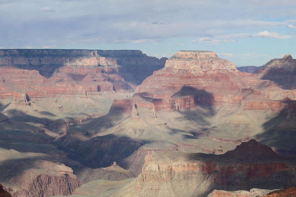
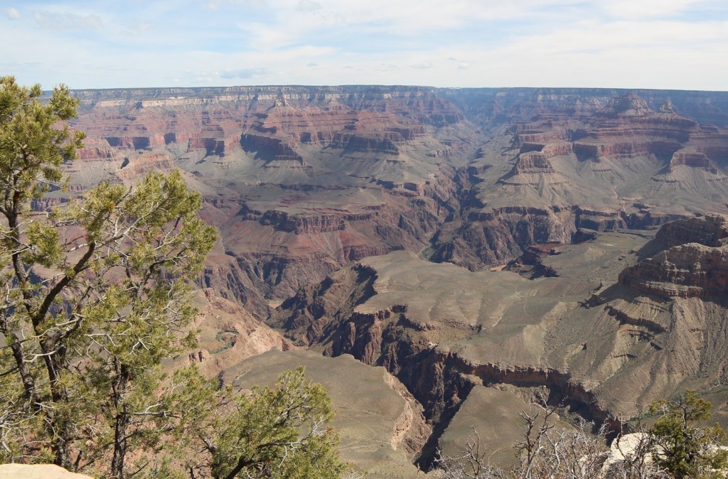
This is the first photo I took from the rim of the Grand Canyon. The views are so expansive, both in distance and depth, that the light from the sun and shadows from cloud cover change what you see from minute to minute. The average width of the canyon from the South Rim to the North Rim is 10 miles. The different colors in the rocks are due to the presence of varying minerals, such as iron oxide, in each layer.
Grand Canyon National Park: By The Numbers
Date established
January 11, 1908 (national monument); February 26, 1919 (national park)
Total area
1,902 square miles
Total visitors
4.73 million in 2023
Elevation
South Rim: 7,129 feet (elevation of North Rim is 8,145 feet); elevation of Colorado River is 2,400 feet
The Grand Canyon’s dimensions are so big that the numbers are related in miles, not feet. Consider that the state of Colorado measures 280 miles from its northern border with Wyoming to its southern border with New Mexico. The Grand Canyon, at 277 miles long, is only three miles shorter than that distance. The width of the canyon is an average of 10 miles. It’s nearly one mile – an average of 5,000 feet – from the rim of the canyon to the Colorado River below.
Here’s something about the Grand Canyon that I find really hard to fathom: the scientists believe that the canyon is only 6 million years old. In geologic time, that is less than the beginning of an eyeblink. Prior to the 1966 completion of Glen Canyon Dam, upriver from the Grand Canyon, during spring and summer runoff hundreds of thousands of tons of sediment would be carried by the Colorado River – each day. That water, pushing and pulling and tossing sand, gravel, rocks, and boulders through the canyon, gouged what is now a mile-deep course through what is now northern Arizona. The erosional forces also included precipitation and freezing and thawing of water along the canyon’s walls.
Early European-American residents of the American Southwest recognized that the Colorado River had to be tamed in order to prevent it from wiping away those resident’s properties during spring and summer floods. Creation of the national monument in 1908 and eventual designation of Grand Canyon National Park in 1919 assured that no manmade water diversion projects would be constructed within the boundaries of the park.
This is the second image I took of the Grand Canyon. The multicolored and clearly delineated rock layers, including sandstone, limestone, shale, schist, and others, range in age from 2 billion years old at the bottom of the canyon to 250 million years old at the top, nearly one mile above the Colorado River.
Beginning from Lees Ferry on the east to Grand Wash Cliffs on the west, the Grand Canyon measures 277 miles in length (at 280 miles, the state of Colorado is 3 miles longer from its northern to southern borders) . Two great manmade structures bounding the Grand Canyon, Glen Canyon Dam and Hoover Dam, create two immense reservoirs, Lake Powell and Lake Mead respectively, to manage the Colorado River’s water flow.
As it flows through the Grand Canyon, the Colorado River has an average depth of 35 feet and a width that varies from 76 feet to 300 feet. During normal operations of Glen Canyon Dam (and when the American Southwest isn’t enduring its ongoing decades-long drought), almost 130,000 gallons of water moves through the canyon’s inner gorge every second – enough to fill an Olympic-sized swimming pool in 5 seconds. The volume of water released through the canyon is often dependent on municipal electricity demands from cities as far away as Los Angeles. The Colorado River used to flow 1,450 miles from La Poudre Pass in Colorado’s Rocky Mountain National Park all the way to the Gulf of California; municipal and agricultural demands on the river in the southwestern United States cause the river to gradually dry out shortly after crossing into Mexico.
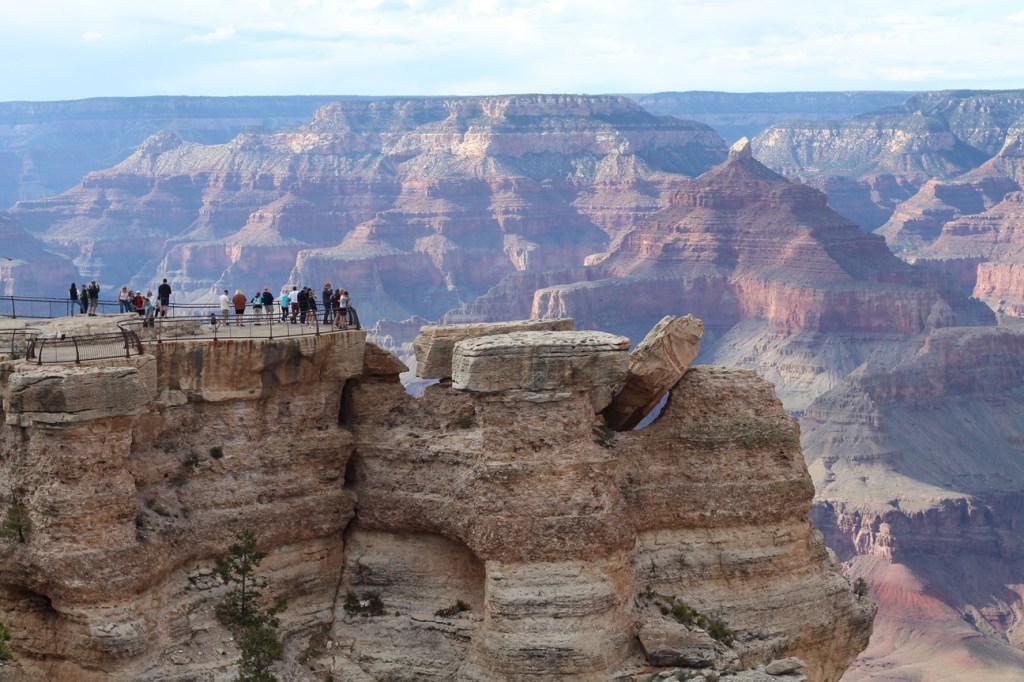
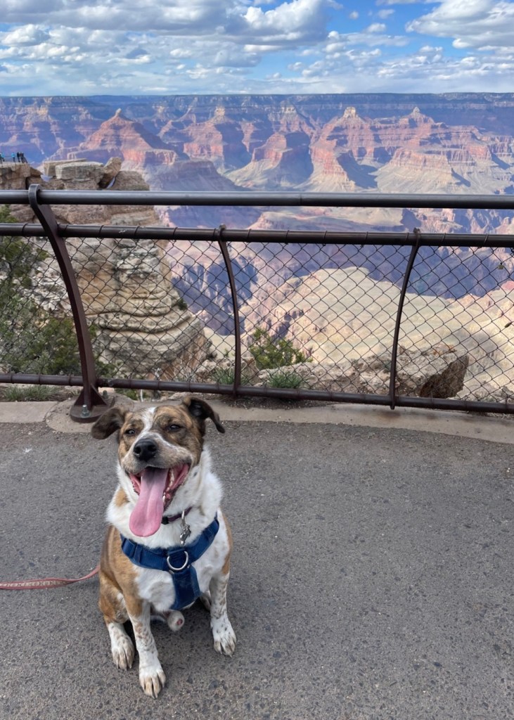
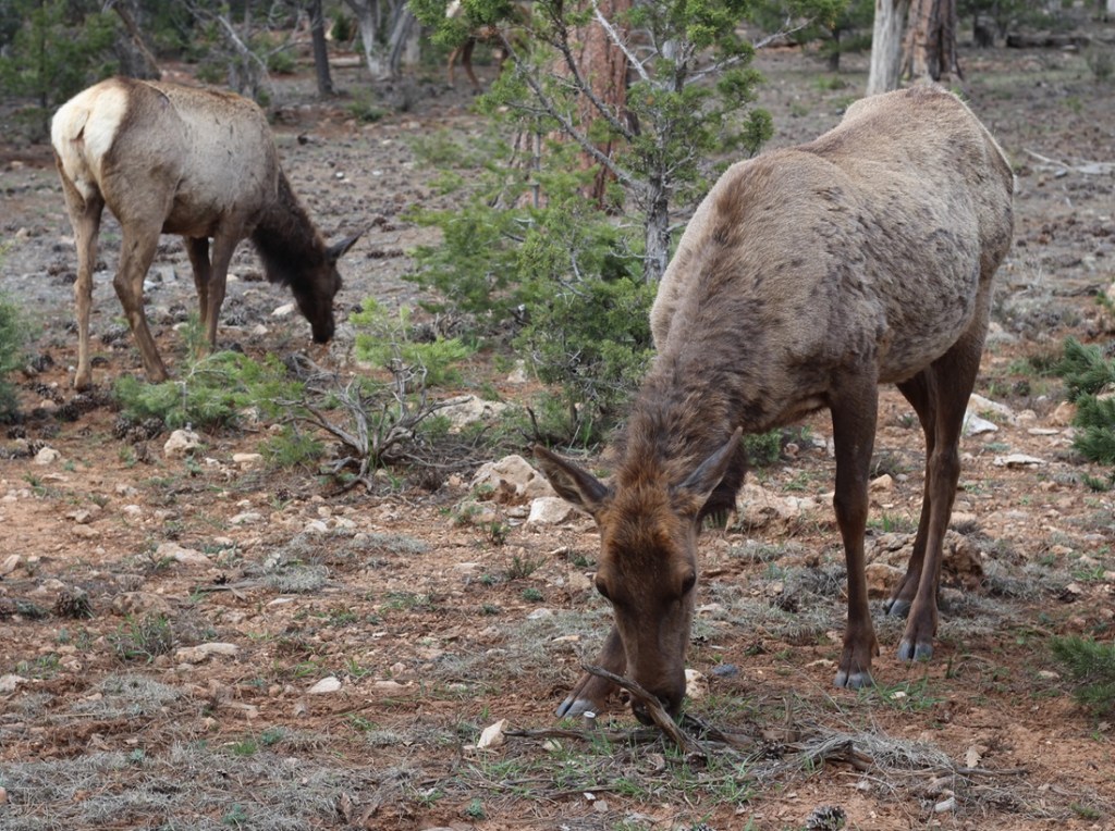
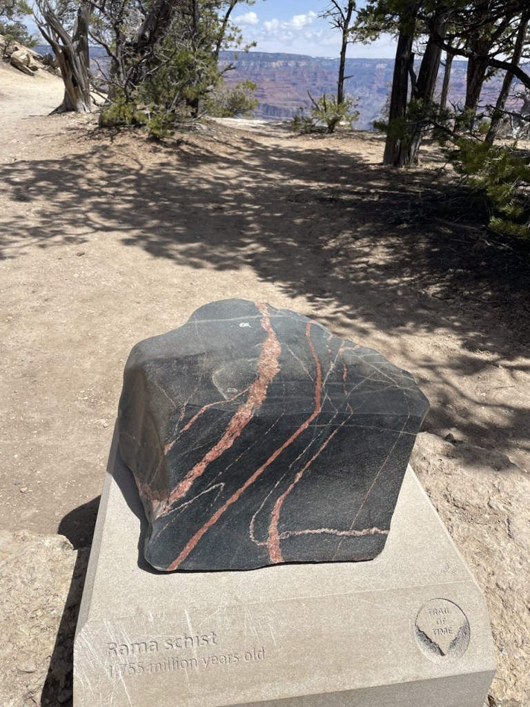
We’ve all seen plenty of canyons across the country and around the world, most of which are easily identifiable by the watercourse that originally carved them. But, in many places, the Colorado River isn’t visible from the rim of the Grand Canyon – there are too many smaller canyons, many of which would be significant geologic features on their own anywhere else – that block the view. The Grand Canyon is a supercanyon of canyons. (This is the third photo I took of the Grand Canyon, by the way. I took hundreds. I won’t post them all, I promise.)Here, then, is the fifth photo I took of the Grand Canyon. We weren’t the only visitors to the national park that day. This is a group of people at Mather Point, one of the larger overlooks that extends into the canyon. Clear days at Mather Point provide views of up to 30 miles to the east and 60 miles to the west. The overlook, along with a campground in the national park, is named after Stephen Tying Mather (1867-1930), the first director of the National Park Service.Here we see a visitor (it’s Gunther) to Grand Canyon who, like me, is experiencing his first few hours at the national park. Gunther was able to join us on our first visit to the canyon’s South Rim, which has a mostly paved walking trail extending 13 miles. That’s Mather Point in the left mid-background.At an elevation of 7,000 feet above sea level, the South Rim of the canyon features an extensive ponderosa pine forest. The campground in which we parked the Goddard was a very pleasant one-mile walk through this forest, which also includes Gambel oak, mountain mahogany, and elderberry shrubs, to the canyon. And there were elk in the forest. Lots and lots of elk. On a couple of occasions, we saw elk grazing perhaps 10 feet from our fifth-wheel home. Some local residents we met on the trail said the elk, just prior to big-game hunting season in the fall, have an uncanny ability to move from the Kaibab National Forest into the protected lands of Grand Canyon National Park.I took this photo with a wide-angle lens in a vain attempt to capture some of the vistas from the rim of the Grand Canyon. This is looking west-northwest further west from the Visitor Center, down the park’s Rim Trail. In the direct middle of the photograph is a light-brown spot, at the bottom of the canyon. Yep, that’s the Colorado River, a mile below the rim and probably two miles north of this viewpoint. The temperatures at the bottom of the canyon are typically 30 degrees higher than at the rim.The Rim Trail, which follows 13 miles of the South Rim, has a pretty nifty display called the Trail of Time in which millions (and billions) of years of the earth’s existence are represented by steps on the 1.5-mile section of trail. The intent is to illustrate the incredible amounts of time that are represented by the different types of rocks found in the canyon, with more than a dozen clearly defined layers from top to bottom of the canyon. The further along the Trail of Time you walk, the (figuratively) further back in time you go. Along the way are representative rocks from the different depths of the Grand Canyon. Pictured here is a pretty sample called Rama Schist, which is from a part of the canyon that’s just under 1.8 million years old. Geologists believe that the Colorado River began forming the Grand Canyon by carving through the 250-million-year-old Kaibab Plateau layer about 6 million years ago, meaning the canyon is only 2.4 percent as old as even its uppermost (and youngest) rock layer. Since then, it has only carved deeper and the canyon is now a mile deep – although its erosional power has been greatly reduced by manmade dams upriver.Here’s another view. looking west-northwest again, a little further down the Rim Trail. The mighty Colorado, still a light brown smudge, is in the lower right corner of this image. I was not expecting so much tree growth at the top of the canyon, but the Rim Trail is heavily shaded for long stretches.
The South Rim of the Grand Canyon receives about 15 inches of precipitation annually, while the North Rim receives just over two feet. The winter of 2022-2023 was an exception, at least for the North Rim. While we were at the South Rim in late April 2023, there was still snow visible on some north-facing walls of the canyon. Because of huge amounts of snowfall during the winter of 2022-2023, the roads leading to the North Rim of the Grand Canyon wouldn’t open until early June.
One more wide-angle view, which depicts some the thousands of smaller canyons in the park that lead into the Grand Canyon. The Colorado River is visible in this image, just to the lower-left of center and to the right of the tree limbs.
The Grand Canyon was designated a UNESCO World Heritage Site in 1979. Those sites are deemed to contain “cultural and natural heritage around the world to be considered of outstanding value to humanity.” These sites must be unique, geographically and historically identifiable, have a special cultural or physical significance, and be under a system of legal protection. UNESCO World Heritage Sites can be ancient ruins, deserts, islands, mountains, wilderness areas, and other natural or manmade features. As of July 2024, UNESCO had recognized just over 1,200 World Heritage Sites; Mesa Verde in Colorado and Yellowstone in Wyoming are examples of other U.S. national parks that are also UNESCO World Heritage Sites.
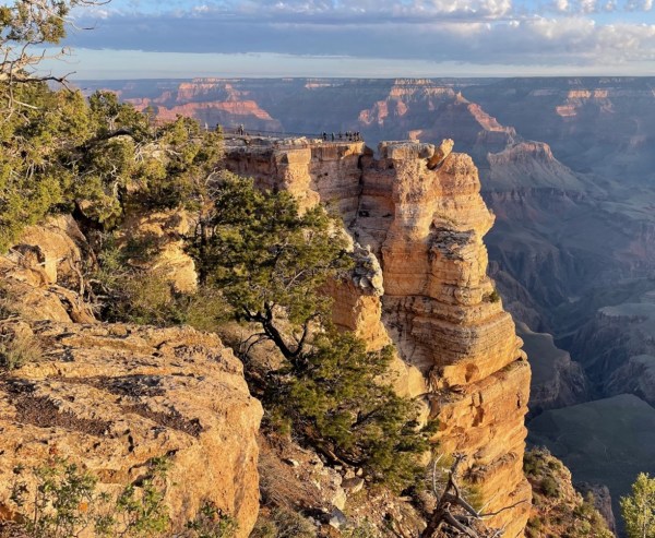
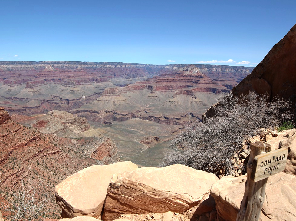
Leaving Gunther at home for a few hours one day, Nancy and I went on a great hike down into the canyon on the South Kaibab Trail to see this view looking across the eastern Grand Canyon. The sign at lower right indicates viewers’ usual reactions.Here we see an intrepid hiker (it’s Nancy) making her way from Ooh Aah Point, beginning the return to the canyon rim on the South Kaibab Trail. This view is looking north.This view, from a point about as far west as we walked on the Rim Trail, is looking east toward the Visitor Center. The zig-zagging line at the bottom of the image is the Bright Angel trail, which Nancy hiked with friends some years ago. It’s an aggressive hike.One more view of the Mather Point overlook: on the morning of April 25, 2023, Nancy and Gunther and I got up early to watch the sunrise at Grand Canyon National Park. The low angle of the dawn’s rays gave the canyon’s features added depth and still more colors that we hadn’t yet seen. This is nearly the same perspective as the fourth photograph in this blog, but compare the coloration and shadows between the two images. The sun has risen on this landscape 2.2 billion times since the Colorado River began carving the canyon. This was just one of those times, but it was still spectacular.
If you’ve been to Grand Canyon National Park, you know this: it’s a must-see park; if you haven’t been, know this: you must see it. The views are simply unmatched, at least in my experience, and the hiking opportunities range from level and paved trails to “park rangers may not be able to come rescue you,” with everything in between.
For such a recent addition to the Earth’s surface (seriously, 6 million years of erosion on this planet is absolutely nothing in the grand scheme of things), the Grand Canyon is an amazing spectacle that really has to be seen in person to get a full appreciation of its beauty. As much as I’ve gone on and on about it, you won’t be prepared when you see it, either.
A little more than 66 million years ago, a metallic asteroid the size of Mount Everest slammed into what is today the upper Yucatan Peninsula in Mexico and things really haven’t been the same since.
For one, the impact directly or indirectly caused the extinction of three-quarters of all organic life on Earth, including all of the dinosaur species that couldn’t fly. A dust cloud from the impact entered the planet’s atmosphere and blocked the Sun for months, preventing photosynthesis in plants, causing catastrophic climate change, and immediately or eventually killing any terrestrial animal weighing more than 55 pounds, except for some cold-blooded amphibious species such as sea turtles and crocodiles. The impact also caused tsunamis to crash against the coastal areas of the planet, and, because the asteroid crashed into a bed of gypsum, immense quantities of sulfur trioxide were thrust into the atmosphere to later fall as acid rain for days.
The Santa Fe Trail, a major trade, military, and settlement route connecting Kansas City, Missouri, and Santa Fe, New Mexico, cut through the middle of what is now Raton, New Mexico. The area had a post office called Willow Springs from 1877 to 1879, then it was changed to Otero for a couple of years before being renamed Raton in 1880. The city became a center for the railroad, mining, and ranching industries in northeastern New Mexico. This is looking southeast from the hilltop on which the iridium layer is located. All of the mountains on the horizon are extinct volcanoes that arose and erupted many millions of years after the end of the Cretaceous Period.
In short, Earth was a place best avoided for the near- and medium term following the planet’s encounter with an asteroid. In addition to being much colder because of the dust cloud blocking the sun, the lack of plant life due to the cessation of photosynthesis doomed herbivorous dinosaurs like triceratops and titanosaurs, and later the carnivorous genera, like abelisaurids and tyrannosaurids, that preyed upon them.
A lone hiker (it’s Nancy) stands a silent vigil near the K-Pg boundary. The city of Raton has placed this helpful sign to assist in identifying the inch-thick layer of clay containing high concentrations of the element iridium. The layer is sandwiched between sandstone dating back to the Cretaceous Period, when dinosaurs ruled the Earth, and sandstone and coal from the Paleogenic Period, when mammalian species began to flourish.
Things are better today, of course (with the exception that there are no more Tyrannosaurus rexes running around, and even that’s probably for the best). The impact had a huge influence on how life on the planet, including the eventual species of H. sapiens, was able to emerge and evolve.
When I was a kid, an asteroid crashing into the Earth was only one of several hypothesized reasons for the disappearance of the dinosaurs. The existence of a particular layer of sediment, originally discovered in Italy but since found around the world, was a major factor in the popularity of that hypothesis: dinosaur fossils, footprints, and other artifacts could be found below this layer, but not above. That particular layer of sediment, which has since been found in many locations around the globe, is unique in that it contains as much as 160 times more of the element iridium than other layers of the Earth’s crust. Iridium (atomic symbol Ir and atomic number 77) is a metallic element found commonly on asteroids flitting about the cosmos, but it’s not found naturally occurring on Earth except when one of those asteroids flits into the planet.
However, until the actual crater for the possible asteroid impact 66 million years ago was discovered, the theory remained only one of the possibilities for what is now called the Cretaceous-Paleogene (K-Pg) extinction event (again, when I was young the K-Pg event was called the Cretaceous-Tertiary, or K-T, event; the “K” is used instead of “C” for Cretaceous because the German word for “chalk,” from which the Latinate “Cretaceous” is derived, is “Kreide”). Some scientists believed that the layer, and the mass extinction event that it documented, could have been caused by the explosion of a relatively nearby supernova, or by gradual climate change, or by a reversal of the planet’s geomagnetic poles (you can understand how magnetic north becoming magnetic south, and vice versa, would be undesirable).
In the early 1980s, a crater more than 90 miles in diameter (about the combined area of Massachusetts, Connecticut, and Rhode Island) and between 6 and 12 miles deep was discovered near the town of Chicxulub (pr. “cheek-shoe-LOOB”) on the Yucatan Peninsula, and chemical and geologic analysis of the impact site showed that scientists finally had their hole in the ground proving that the age of the dinosaurs was ended by an asteroid collision. Researchers believe the Chicxulub asteroid was probably about six miles wide – tiny compared to the Earth, but it was hurtling along at about 12 miles per second so it was ready to do some damage.
Incidentally, I read an interesting book several years ago about past extinction events on Earth, one of which was the Chicxulub impact, and the book’s author wrote that the explosive nature of the asteroid collision was so violent that vaporized bits of organic matter on the planet’s surface could have been ejected into space. The author asked a researcher if it’s possible that there are tiny bits of dinosaurs on the Moon, and the researcher said that yes, it is possible that there are tiny bits of dinosaurs on the Moon.
But I digress. Life on Earth was drastically changed after the asteroid impact, and, with the exception of smaller flying lizards that could more easily find food and shelter (and which would evolve into our feathered friends of today), the dinosaurs were no more – and an age in which mammals could diversify and grow in species number had begun.
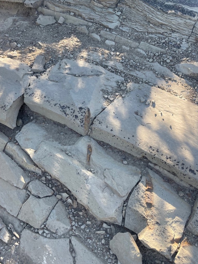
Despite the signage, it’s a little difficult for laypersons like ourselves to positively identify the exact layer containing iridium. However, we believe it to be the one-inch-thick layer of light-colored clay material directly above the very dark layer of rocks pictured in the center of this photo (if any experts happening to read this posting dispute this, I’ll happily correct this information). The iridium layer contains, in addition to large quantities of the titular element, shocked quartz and other materials indicative of an asteroid strike. All of the material under that layer is at least 66 million years old; everything above it was deposited after the age of the dinosaurs.
Because iridium exists on the planet only because of asteroid collisions, it’s one of the least-common elements on Earth – it’s four times as rare as gold. Iridium is one of the densest metals on the planet: a cubic inch of iridium weighs just over three-quarters of a pound (12.96 ounces, to be precise). Only one element, osmium, is more dense than iridium and it’s just barely so; osmium (Os) and iridium are both twice as heavy as lead (Pb, which has that symbol because of its Latin name, plumbum). Iridium’s resistance to heat and corrosion lends itself to uses in metallurgy (such as crucibles for less-dense metals) and electronics.
Many years ago, the steel nibs of fountain pens were tipped with alloys containing iridium in order to take advantage of the element’s hardness and resistance to corrosion. Most nibs then, as now, were made from steel. Over time, constant usage of the pen would wear down even the steel of a nib – so manufacturers tipped the nibs with harder metals like iridium to prolong their usage. However, iridium has become so difficult and expensive to source (and, given where the element comes from, we really don’t want more iridium on the planet anytime soon) that fountain pen nib manufacturers now use alloys of ruthenium, osmium, and tungsten (but sometimes, confusingly, call those alloys “iridium”). This is a 10x magnification of one of my fountain pens, a Pilot Custom 823. The nib itself is made of 14k gold for flexibility while writing, but the tipping, or the somewhat rounded extreme end of the pen, is made of harder alloys.
The K-Pg layer was first discovered in Italy but since then many other outcroppings of the iridium layer have been found around the world. One of those occurrences is near the small town of Raton, New Mexico (pop. 6,000), where we camped in the Goddard in the spring of 2024. Raton (Spanish for “mouse”) is about six miles south of the New Mexico-Colorado border in the far northeastern corner of the Land of Enchantment.
Nancy and I visited the site of the iridium layer late one afternoon in early May. I’d secured a permit to visit the site the day before at Raton’s municipal office. It turned out we didn’t really need a permit because it simply supplied the combination to a locked gate on the road and permission to park at the iridium layer site, and we didn’t think that there’d be room for the Goddard’s six-wheeled and 22-feet-long towing unit. We instead parked the towing unit downhill from the iridium layer site and hiked past the gate and then a mile or so to the site itself (the walk the day before from our campsite to the municipal office to acquire the permit, which we didn’t need, and back was 5.5 miles). Both were lovely walks (I saw a small group of mule deer in the front yard of a house in Raton on the way back to our campsite).
It further turned out that we could have driven the towing unit to the site, as there was plenty of room to park and turn around. But, as I mentioned, they were lovely walks.
We didn’t see much in the way of wildlife on our visit to the iridium layer, but we did encounter several of these rock wrens (Salpinctes obsoletus) on our walk back to the Goddard’s six-wheeled towing unit. These little birds weigh only about half an ounce, with a wingspan of 9 inches. Northern New Mexico is at the very northern edge of their year-round residency area; they are migratory into southwestern Canada.Since this posting is sort of about dinosaurs, I’ll include a couple more photos of the dinosaurs’ descendants that I took at our campground in Raton. This is a chipping sparrow (Spizella passerina), of which we saw many in Raton. There are two major groups of chipping sparrows in North America, eastern and western, and each of those groups have different varieties. As someone who struggles with sparrow species identification, I appreciate the chipping sparrow’s distinctive lil’ red cap.There were also plenty of common ravens (Corvus corax) in the campground and Raton. These are large birds – measuring up to 25 inches long, weighing 3.2 pounds, and boasting a wingspan of up to 5 feet – and they are remarkably long-lived as well: more than 23 years in the wild. Many people have trouble differentiating ravens from their smaller cousins, American crows, but ravens are on the whole larger, with wedge-shaped tails and much larger beaks in proportion to their heads. Like many other corvids, ravens are noted for their problem-solving abilities.
The few dinosaurs that survived the Chicxulub impact are the ones that were able to take to the skies, and their evolutionary descendants include rock wrens, chipping sparrows, and common ravens, as well as American white pelicans, common ostriches, Anna’s hummingbirds, emperor penguins, and others that comprise the 11,000 species of birds with which we share this planet.
One might wonder about why a one-inch layer of dirt that’s found around the world is important. I think it’s instructive to consider what life on Earth would be like had the planet not been pummeled by an asteroid 66 million years ago. Dinosaurs were the dominant lifeforms on Earth for around 175 million years, from their first appearance during the Triassic Period about 240 million years ago to being (mostly) destroyed by the Chicxulub asteroid. That’s an awfully long time to dominate; in fact, our existence as humankind is closer to the time that Tyrannosaurs were alive than the time between the Stegosaurus genus and Tyrannosaur genus were both alive; the former was even fossilized by the time T. rex had evolved. It’s very possible that gigantic, ground-shaking, and ferocious (and small-brained) lizards could still be the most dominant animals on the planet, and that mammals, although they’d first appeared on Earth well before the Chicxulub asteroid collision, would never have had the opportunity to gain a strong foothold with which to start their evolutionary path.
In short, you can probably thank the Chicxulub asteroid for you being here today. Also, it wouldn’t hurt to hope that a similar impact doesn’t occur anytime soon.
Grand Staircase-Escalante National Monument is big – really big. In fact, although it’s the seventh-largest U.S. national monument by size, it’s the biggest in the country that’s not either entirely in or adjacent to an ocean. At 1.87 million acres (just over 2,900 square miles), the national monument is nearly twice as big as the entire state of Rhode Island, and just a tad bigger than the state of Delaware.
This area in southern Utah is vast, and it is remote: it was the last part of the contiguous United States to be mapped by the federal government. Grand Staircase-Escalante National Monument was authorized by President Bill Clinton in 1996. This is also one of the more contentious federal properties; President Donald Trump effectively halved its acreage in 2017, and then President Joe Biden restored it to its current size in 2021. It is the first national monument to be administered solely by the Bureau of Land Management (BLM).
(A brief sidenote: the U.S. government’s holding of lands, especially at the levels of national monuments and especially those in the western United States, is criticized by some groups and lauded by others. Much of these lands frankly isn’t good for anything except looking beautiful and supporting native plants and animals – which, in the eyes of some, is more than enough reason to provide federal protection. Other groups are interested not so much in the lands themselves, but what’s under the lands’ surfaces: minerals, petroleum, and other extractive materials. Everyone from kayakers to native Americans to miners to anglers to ranchers to tourists wanting a scenic drive has an opinion on what should and shouldn’t happen on these lands. U.S. presidents are able to establish and change landholdings under national monument status as they see fit; acts of Congress are needed to establish or change national parks. I’m someone who enjoys nature quite a lot, but I also realize that I use minerals and petroleum extracted from the earth nearly every minute of every day – in the laptop I’m typing on, in the fifth-wheel trailer in which we live, and in the iPhone and digital camera with which the following photos were taken. You most likely are equally dependent on those extractive resources. As with most issues in life, it takes a balance. Grand Staircase-Escalante National Monument is especially contentious because county and state governments also want to maintain at least some control over what can and can’t happen within its borders.)
(That sidenote was less brief than I’d expected.)
Anywho, Grand Staircase-Escalante National Monument takes up a sizable chunk of southeastern Utah. It protects three major areas: the Grand Staircase, the Kaiparowits Plateau, and the Canyons of the Escalante. The Grand Staircase is so named because of its stepped appearance if viewed from the side: from west to east, the landscape drops in elevation in enormous eroded and even layers. The steps drop, west to east, in cliffs measured in hundreds of feet. The area represents 400 million years of geologic development.
The views at Grand Staircase-Escalante National Monument are simply spectacular. The monument is bordered by Bryce Canyon National Park on its western edge and by Glen Canyon National Recreation Atea on its eastern side.
One fun thing to do in these federally protected lands is to go on a hike, and that’s what Nancy and I did in late May of 2023. The Toadstool Trail leads to some wonderful rock formations and other features of this otherworldly environment. In its easy out-and-back 1.5 miles, one can see rocks eroded from water, rain, and other elements to create some pretty stunning scenery. We happened to visit the area when a number of flowering desert plants were in bloom, which was great to see.
We visited the national monument on a beautiful day in late spring, when there was little chance of rain, but there was plenty of evidence that the area receives considerable amounts of moisture at times. This ravine was cut by a seasonal watercourse; the hiking trail is at the far right of the photo. Note the coloration of the different layers of rocks in the cliffside.This pretty flower is a sego lily (Calochortus nuttallii), which happens to be the state flower of Utah. We saw quite a few of these blossoms, which can measure up to three inches across, on the hike. “Sego” is believed to derive from the Shoshone name of the plant.There’s a lot going on in that cliff, not the least of which is the wavy nature of the rock layers on the left. I took this photo from a U-bend in the trail (it continues on the left and right of the photo) and you can see some hikers near the center of the photo.This is a TALES OF THE GODDARD LIZARD ALERT. I’m not an expert on reptile identification (I’m not really an expert on anything, come to think of it), but I believe this to be a common side-blotched lizard (Uta stansburiana). They grow to a length of about 2.5 inches not including the tail, which is often longer than the body. Judging from the Wikipedia page on these little rascals, a lot of the scientists have spent a lot of time observing this species. This is a lizard that can safely lose its tail to escape a predator, but that comes at a terrible cost: loss of social status within a group of other common side-blotched lizards. We saw several of these lizards and all still had their tails, so we were among the elite. This isn’t the first lizard species to live in the area; researchers have found fossils of several different dinosaurs within the borders of the monument.This is the largest rock formation from which the Toadstools Trail gets its name, and it’s plenty spectacular. If I had to guess, I’d say the column is about 25 feet tall. Formations like this occur when softer rock under harder, denser rock is eroded away. These are basically small buttes, with more material underneath the surface caprock taken away by water, wind, and other erosional forces, to form a toadstool formation.I thought this rock wall was interesting because it shows not just the colors of the different rock layers, but the different density of the layers as well: note the edge-on layers of rocks upon which less-dense layers, which are disintegrating faster, were deposited over millions of years.The bright blossoms of this plains pricklypear (Opuntia polyacantha) were hard to miss in an otherwise tan-colored environment. The flowers of this species of cactus can be yellow, red, or magenta, as on this specimen. These plants provide a source of food for quite a few animals, like prairie dogs and pronghorns, and many people enjoy eating the fruit (if animals haven’t gotten to them first) once the blossoms are spent.Although the larger toadstools are very impressive, the rock formation – a column supporting a wider, flat cap of harder stone – is fairly common in the area. They make for some interesting viewing opportunities.This is Coulter’s lupine (Lupinus sparsiflorus), also known as Mohave lupine or desert lupine. The plants grow to a maximum height of about 16 inches. We’ve seen this pretty flower elsewhere in the deserts of the western United States; it, along with the other plants that happen to be flowering at the time, provides a nice pop of color.This blurry photo is unfortunately the best of three I took before this rock wren (Salpinctes obsoletus) took off to raise havoc somewhere else. This species, fairly common in the western part of the country, is adapted to cling to rock faces while hunting for insects and spiders.Shortly after we’d started this hike, another hiker suggested that we continue walking past the main toadstool formations for some really nice views, more toadstools, and balanced rocks. We took his advice, and we’re glad we did. I’m going to guess that it’s six or eight miles to the horizon. Here we see a lone hiker (it’s Nancy) looking west; Kanab, Utah, is about 40 miles thataway.In this very arid environment, anything that moves and (especially) is not some shade of brown quickly catches your eye. This caterpillar is the larval stage of a really nifty moth called the white-lined sphinx, or hummingbird moth (Hyles lineata). The adult version of this species can be easily mistaken for a hummingbird as it hovers over blossoming flowers. The species is very common from central America up into Canada, including most of the United States. The spike at the back end of the caterpillar isn’t a stinger but it does give this larval form another name: hornworm. They aren’t harmful to humans but given a big enough population, these voracious eaters can destroy cultivated crops and flowers. Conversely, the adult moth form is beneficial for plants because of its ability to pollinate while feeding.That hiker who suggested that we continue our walk past the main formations was absolutely right, and we were able to see some really pretty toadstools and long vistasThe yellow blossom on the left is red dome blanketflower (Gaillardia pinnatifida), while the white blossom belongs to a flowering plant called birdcage evening primrose (Oenothera deltoides). Because they don’t require a lot of care, blanketflower species are very popular in home flower gardens – I planted some of them in our xeriscaped lawn in Denver.The cliffs, toadstools, balanced rocks, and other rock formations in the national monument were created by erosion and plenty of time. I’m including this photo to show how even tiny trickles of water coming down a rock face can create really interesting designs.Native American cultures arrived in what is now the national monument around 1,500 years ago. There are hundreds of petroglyphs that document those peoples’ existence in the area, and the rock in the foreground looks to have two of them. This was at the mouth of a very short canyon eroded into a cliff wall.Here’s a closeup of one of the petroglyphs on the rock pictured above. I have no reason to think it’s not genuine, but I sure can’t think of any horned quadrupeds that also have long tails. Maybe it’s a depiction of something else entirely.On the way back to the trailbead, another hiker with a digital camera and long lens was as excited as me to see this bird about 50 yards away from us. We couldn’t identify the species at that distance, so I was certainly looking forward to getting back to the Goddard and looking at the picture on a larger screen. “What kind of exotic birds could possibly live in this remarkable desert environment?” thought I, taking picture after picture of a bird I couldn’t make out through the camera lens. Turns out, it’s a house finch (Haemorhous mexicanus) which is common all over the country so it’s not nearly as exciting as I first thought. However, I’ve gone some days without seeing any birds at all and those days aren’t any fun so I’ve learned to appreciate all the birds I see, no matter how common they are.This photo was not taken on the Toadstools Trail, but I wanted to include it in this posting about Grand Staircase-Escalante National Monument. It shows a spectacular bluff above a former townsite called Paria, which was a Mormon settlement from 1870 to 1929. The town was abandoned because it kept getting inundated by floodwaters. It must have been a tremendously hard way of life, separated from other communities by dozens of miles, but at least the view was pretty good.
About 190 million years ago, much of the present-day southwestern United States was covered in an immense field of sand dunes – one of the largest that has ever existed on the planet. Many of the dunes happened to carry iron pigment, which turned red when it was oxidized by the sun.
Over the course of millions of years, and with the help of chemical compounds like calcium carbonate and iron oxide, the dunes were slowly cemented into a rock called Aztec sandstone.
These sandstone formations are the primary feature of Red Rock Canyon National Conservation Area, located only about 15 miles west of the casinos, hotels, nightclubs and other delightful debauchery of Las Vegas, Nevada. The area includes nearly 200,000 acres (about 300 square miles) of the Mohave Desert, and it’s visited by 3 million people each year – a little less than what Yellowstone National Park in Wyoming receives.
It’s an impressive number of visitors, to be sure. I think, however, that most of Red Rock Canyon’s visitors are from the Las Vegas area. Its canyons and sandstone cliffs make it remarkably unlike most of the rest of the flat desert surrounding the city, and it’s extremely popular with hikers, cyclists, and rock climbers. Consider that Las Vegas’s Harry Reid International Airport (until 2021 McCarran International Airport) saw almost 58 million passengers arrive and depart in 2023, and it’s easy to see that most of those people aren’t coming to The Entertainment Capital of the World to entertain themselves by visiting a national conservation area.
Being avid hikers with interests in geology and biology, Nancy and I (and Gunther) went to Red Rock Canyon National Conservation Area in early December 2023. We were happy to be joined by a Canadian couple we met at the campground in Las Vegas at which we were staying; it turns out that Canadians enjoy hiking as well. They also joined us for a visit to the Hoover Dam, a hike in Lake Mead National Recreation Area, and a hike in Valley of Fire State Park north of Las Vegas (not all on the same day).
A one-way scenic drive, a loop 13 miles in length, at Red Rock Canyon provides many pullouts and parking lots with access to hiking trailheads (beginning a total of 22 trails ranging in length from under one mile to more than 10 miles), overlooks, and other points of interest.
It’s easy to see how Red Rock Canyon got its name. The sand originally forming the dunes contained an abundance of minerals, one of which was iron that was oxidized by the elements over millions of years. The area began its federal protection in 1967, when the Bureau of Land Management (BLM) designated 10,000 acres as the Red Rock Recreation Lands. Further legislation over the years and significant additions of acreage eventually led to the National Conservation Area designation in 1990.I was struck by the clear delineation of colors in the rock. These two different colors of rock are both types of sandstone, but water moving through the sand at the bottom millions of years ago took away the red minerals and left behind calcium carbonate. The sand later developed, over even more millions of years, into sandstone.Erosional forces like water and wind result in some really cool-looking rock formations. Note, also, that the light-colored and red layers of rocks are the reverse of the photo above (and I didn’t post it upside-down).These huge sandstone blocks are not naturally formed: they’re remnants of one of the earliest industries in the Las Vegas area. The Excelsior Stone Quarry began operations in 1905, extracting blocks of sandstone for use as building materials. The blocks, some weighing up to 10 tons, were pulled with a 17-ton steam-traction engine to the just-built railroad in Las Vegas and loaded onto railroad cars bound for Los Angeles and San Francisco, where they served as decorative building material. While the sandstone was judged to be of exceptionally fine quality, quarries closer to California’s coastal cities were later developed and the Excelsior Stone Quarry and other operations in the area shut down for good in 1912. The plant growing in front of the large block is a species of yerba santa, which is Spanish for “sacred herb.” The name comes from the plant’s medicinal properties to treat respiratory and digestive ailments – even today, yerba santa extracts can be found in western U.S. herbal medicine stores.Part of the day included a hike on the Calico Tanks Trail. The long views and beautiful multicolored rock formations along the trail reminded Nancy and me of several places in Colorado, including Garden of the Gods in Colorado Springs and the Red Rocks Amphitheater near Morrison. Two hikers can be seen in the lower-left corner of this image. The BLM has classified the Calico Tanks Trail as “moderate”; I’d say, based on the elevation gain and necessity to scramble up and over rocks, it’s on the far end of “moderate.” It was a beautiful hike, though.These curves in the sandstone were created while the materials were still in the form of loose sand. Wind blowing across the dunes created these lifted layers before the grains of sand were cemented into the sandstone of today.This specimen of Spanish dagger (Yucca schidigera, also known as Mohave yucca) reminded us that we were in the desert. It, like many plants found in the Mohave and other deserts, looks pretty savage.Speaking of savage, Gunther takes a break on the Calico Tanks Trail to enjoy the scenery. He got along really well with the Canadians; he gets along really well with pretty much everyone, no matter their country of origin.This is the feature for which Calico Tanks Trail gets its name: a seasonal pond, or tank, created by water seeping or flowing into a depression in the sandstone (there was a much smaller water feature earlier in the trail, thus the plurality of the trail’s name). The Spanish word for this formation is “tinaja,” which means “clay pot.” The sun on this early December day was pretty low in the sky, making for some considerable shadows from the rock formations. Those of you who have been to Las Vegas will probably think this tank is the third-largest standing body of water in the area after Lake Mead and the fountains in front of the Bellagio resort on the Las Vegas Strip; I would not disagree with that assessment. Formations like this make possible a huge diversity of plant and animal life that otherwise couldn’t survive in the desert.If you squint, the hotels and casinos of Las Vegas can just barely be made out near the horizon in this image, taken at the end of the Calico Tanks Trail. This vantage point took some rock scrambling to get to; along with my phone, with which I took this and most of the rest of the photos in this posting, I was also carrying my digital camera with a large and heavy zoom lens in case we saw any wildlife. A fellow hiker noticed the camera and said I was brave for bringing it along; I corrected him and said I was dumb.So that I didn’t bring my heavy camera lens on the Calico Tanks Trail for naught, here’s a picture of a rock climber I took with it. Rock climbing is a pastime in which I have absolutely no interest in participating.Yeah, this looks like just heaps of fun. The BLM’s website states that rock climbing at the national conservation area is among the best in the world. Red Rock Canyon National Conservation Area is one of more than 850 areas managed by the BLM’s National Landscape Conservation System, which totals 27 million acres of areas designated as National Conservation Areas, National Monuments, Wilderness Areas, Wilderness Study Areas, Wild and Scenic Rivers, and National Historic and Scenic Trails.Longtime readers of this blog know that I won’t pass up an opportunity to post an image of lichen. I have no idea what species this is, but I think the shade of green is best described as “obscene.” Together with wind and moisture, plants and lichens do their part to erode the rocks into all kinds of fantastic formations.This is a view from High Point Overlook (elev. 4,771 feet) looking east toward the city of Las Vegas, which is 15 miles on the other side of the rock formation. High Point Overlook is just a little shy of the midway point of Red Rock Canyon’s scenic drive. The vegetation in the foreground gives an idea of what the flat parts of the area are like; it appears kind of sparse, but it’s much more heavily vegetated than other areas we’ve seen around Las Vegas. There are about 600 species of plants found in the conservation area, a number boosted considerably by the presence of year-round water: the sandstone allows water to percolate, creating springs, pools of standing water like the Calico Tanks, and even small creeks and waterfalls .This is Turtlehead Peak (elev. 6.323 feet), also photographed from High Point Overlook. There’s a trail to the top, but it’s 5 miles round-trip with a 2,000-foot elevation gain, and Gunther didn’t want to try it so we didn’t. That’s a heavily laden Utah juniper (Juniperus osteosperma) on the left, with Mormon tea (Ephedra nevadensis) growing at its base.I wasn’t planning to see any natural bodies of water in Red Rock Canyon National Conservation Area, let alone one that was flowing. This is Lost Creek, along which we saw a huge diversity of plant life flourishing in early December. I will remember this very short hike off the scenic loop for a couple of reasons: this stream, and the fact that Nancy bonked her head on a low-hanging ponderosa pine branch that was overhanging the trail; she didn’t see it because of her hat brim. If she hadn’t been in the lead of our hiking party, any of the other three of us would probably have bonked our heads (even though he was ahead of Nancy, Gunther didn’t bonk his head because he’s an expert hiker. And he was able to just walk under the branch, without making note of the obstruction to Nancy.) We’ve discovered that the maintenance of trails in the federal system can vary greatly; BLM trails are perhaps the most … rustic. It’s really not a problem, and I’m certainly not complaining. It’s just interesting to see.Here’s an example of the diversity of plant life in Red Rock Canyon National Conservation Area: a specimen of ashy silktassel (Garrya flavescens), growing along Lost Creek. I’ve never knowingly seen it before. It can grow up to about 10 feet high. Another short trail from the scenic loop leads to a grouping of petroglyphs and pictographs, created by native Americans thousands of years ago. The minerals in rock exposed to the intense desert sun over the millennia develop a dark patina called desert varnish. The native Americans removed the patina with stone tools to expose the lighter colors of the original rock beneath, creating designs known as petroglyphs. Pictographs, in contrast, are designs created with paints made with clays, charcoal, and other minerals, and then applied to the rocks.Here’s a closer view of the petroglyphs in the photo above this one. The meanings or significance of these designs have been lost to time; the only communicative records of the people who created these designs that still exist are the petroglyphs themselves. Nancy and I have seen quite a few petroglyphs in New Mexico and Arizona, but it was a bit surreal to see these ancient designs just 15 miles from the (barely) controlled 24-hour party of the Las Vegas Strip.Here’s an example of a pictograph, or an image painted on the rock, located just a few yards away from the petroglyphs. It’s a little hard to see in this photo, but petroglyphs and pictographs are themselves sometimes hard to see in the wild. There’s a closer view of the pictograph below.The pictograph looks like a figure 8 with a vertical line inscribed through it (it’s just to the right of dead center in the photograph above). Again, we have no idea what its significance is, but it must have been important to someone a very long time ago. The BLM and other federal agencies take great care to protect these cultural artifacts; like in other areas around the country, the precise locations of many of the pictographs and petroglyphs in Red Rock Canyon are not made available to the public. Six major groups of native Americans have lived in what is now Red Rock Canyon, beginning with the Tule Springs Paleo-Indian culture 11,000 to 8,000 years ago.
A visit to Red Rock Canyon National Conservation Area had been highly recommended by one of our Lyft drivers who happened to be a native of Las Vegas, and she was right to do so. I mean, we would have gone regardless, but our visit definitely blew past what I thought it would be like. I sure wasn’t expecting to see those incredible views, enjoy fascinatingly colorful rock formations, and go on a hike next to a running stream, let alone appreciate imagery left by native Americans thousands upon thousands of years ago, but Red Rock Canyon had all of that and more. If you do find yourself in the Entertainment Capital of the World and want to experience something completely unlike what Las Vegas is known for, Red Rock Canyon National Conservation Area is a wonderful place to spend a day.
From scenic Tennessee, the Goddard hurtled northward in the summer of 2022 – destination: Michigan, to visit Nancy’s sisters and their families. On the way, we stopped to visit a couple of national parks in Kentucky and Indiana. We’d visited Mammoth Cave, located in central-west Kentucky, some years ago (Nancy’s way into caves – like, way), but it was time for a return visit. We made not one, but two trips underground to visit different parts of the cave; on another day, Gunther also joined us for a fun hike above the surface of the earth.
Mammoth Cave’s story begins, as do so many of the tales recounted in this blog, 350 million years ago when this part of present-day Kentucky (and most of the rest of the current United States) was covered by a vast inland sea. Corals and shell-bearing organisms produced calcium carbonate (CaCO3), which precipitated out of the seawater to fall on the seabed below. There were a lot of corals and shellfish: the CaCO3 their bodies created gradually accumulated to develop a 450-feet-deep layer of sedimentary limestone at the bottom of the sea.
In the ensuing hundreds of millions of years, the sea retreated and the limestone was covered by more layers of shale and sandstone. Mammoth Cave is the world’s biggest example of a solution cave, meaning that it was created when rainwater percolated downward and picked up naturally occurring carbon dioxide in the air and soil to became very weakly acidic. Ten to 15 million years ago, the percolation dissolved enough of the limestone to allow greater volumes of water to flow through the crevices. The force of the Green River took it from there, cutting through the highly erosional limestone using both water pressure as well as a mild acidity present in the river. The passages of the cave closest to the surface are the youngest in the system: only about 2 million years old. While the protective layer of harder shale and sandstone is keeping the brakes on vertical erosion from rainwater, the Green River is still creating more Mammoth Cave under the earth today.
Our guide, National Park Service Ranger Matthew, a retired schoolteacher, welcomes the Star Chamber Tour group to the Historic Entrance of Mammoth Cave. Matthew is a retired schoolteacher. The tour, which started at 6 PM, allowed us to visit the cave as those who entered the cave a hundred years ago did: with oil lanterns. The Star Chamber tour is two miles long and lasted 2 1/2 hours; it was nearly full dark when we emerged from the cave. Ranger Quentin is behind the shrub in the center of the photograph; we talked with him a bit during the tour and he shared that he’d just been informed that he’d been named a full-time NPS ranger. As anyone who has spent time in national parks can imagine, it’s a very competitive position; Quentin is a native of the Cave City area, so it had to be especially rewarding.
Native Americans lived in the area around Mammoth Cave for thousands of years, exploring the cave and using it for mineral extraction. They entered the cave through what is now known as the Historic Entrance, and explored at least 14 miles of the system using only the flame from burning torches for light. Evidence shows that Native Americans stopped using the cave about 2,000 years ago, and the caverns were unknown for more than 200 years.
This is the Historic Entrance to the cave, accessed by a long stairway (the stairs seen at the right of the image above). There are about 30 entrances to the cave system, some of which are just small holes barely large enough to squeeze through.
Local history holds that the first European-American entered the cave in the late 1790s. A young boy named John Houchins was hunting black bear (no longer found in the area) and inadvertently came across the huge hole in the ground that is now the Historic Entrance.
During the War of 1812, the cave’s … significant … deposits of guano (there are 13 known bat species in the park, but not all use the cave) served our nation as a source of saltpeter, a component of gunpowder. Some of the wooden assets used in the guano mining operations are still to be observed in the cave, thanks to its cool and humid environment (54 degrees and 87 percent humidity, all day, every day, all the year round).
The site became a local tourist attraction but, because of the area’s remoteness, didn’t see much out-of-state visitors for many decades until the automobile was developed and popularized. The property was privately owned by different interests through the years, all of which conducted tours of the underground passages, until concern about preserving the caverns’ natural resources resulted in Mammoth Cave National Park being established on July 1, 1941. It is the country’s 26th national park. In its first year as a national park, Mammoth Cave saw about 58,000 visitors; we were two of about 663,000 people to visit the park in 2022.
True to its name, Mammoth Cave is pretty big: in fact, it’s the longest cave system in the world and fully twice as long as the next-longest system. Mammoth Cave is currently mapped to include more than 400 miles of caverns (the entire state of Colorado is 380 miles wide), and the scientists believe that as many as 600 miles of caverns remain to be discovered and mapped. The system has been likened to a bowl of spaghetti, with passages intersecting and moving up and down multiple levels .
Understandably so, flashlights and flash photography were forbidden on the cave tours so the photos I was able to take are terrible because the only light available came from lanterns (on the Star Chamber Tour) or electric lights along the cave passages (on the River Styx Tour). However, some of the photos give a sense of scale to the caverns. Much of the present-day caverns are completely dry – the river water that carved them disappeared quickly into deeper caverns many years ago – so there’s no dripping water to create stalagmites and stalactites, along with other formations familiar to spelunkers. To be honest, although there are some beautiful formations to enjoy, for me most of Mammoth’s impressiveness – and there is plenty of that – comes from its sheer size. Mammoth Cave is big, and it’s dark. I remember a ranger’s tale from the first time we visited the national park: in the mid-1930s, before the park was managed by the NPS, the mummified body of a Native American (who’d lived before Columbus reached the New World and was killed when he was struck by a large falling rock) was discovered on a ledge in one of the caverns. By that time, hundreds of guided tours had passed by the body and all of the people – numbering in the thousands, at least – in all of the tours were unaware that they were passing by the mummy, which was only a few feet above their heads. It was just too big, and too dark, in Mammoth Cave to know about the mummy until someone happened to come across it.
The pandemic limited the number of tours available; some of the tours that Nancy and I went on during our first visit weren’t available at the time of our visit in July (mostly because of a shortage of National Park Service rangers trained to lead the tours). However, we enjoyed the Star Chamber Lanternlight Tour one evening, as well as the daytime River Styx Tour on another day.
The cave’s corridors vary greatly in size: some passages require visitors to walk sideways in order to pass through, and other caverns are wide enough to accommodate a Boeing 747 jet (I didn’t see any aircraft on either tour, but it was pretty dark).
We saw this formation, called the Giant’s Coffin, on both of our tours (which shared a bit of the same trail). Located 175 feet below the surface, the Giant’s Coffin is a limestone nugget measuring nearly 50 feet long and 20 feet tall, and weighing a thousand tons. The rock separated from the limestone wall behind it sometime in the distant past; imagine the sound it made when it fell. Our NPS ranger guide is in the shadows at the left of the photo; if I remember right, she’s standing perhaps 50 feet in front of the Giant’s Coffin.At one point on the Star Chamber Tour, Ranger Matthew asked us to place our oil lanterns in a row on the cave floor. He and Ranger Quentin then extinguished all of the lamps and used a flashlight to guide their way behind a rock wall, leaving us in total darkness (he’d mentioned they’d do this beforehand; they didn’t just sneak off and leave us). If you’ve never been in a completely darkened cave, you’ve never known true darkness: the absence of all light. Even being outside on a moonless night, well removed from city lights, isn’t the same because there’s still starlight to provide some illumination, however feeble. It’s a common occurrence on cave tours, this extinguishing of all artificial light, but it never fails to strike some primeval chord – to not be able to see your hand in an inch in front of your face, let alone across the room. It also gives one a better appreciation for those early explorers: modern spelunkers carry all sorts of redundant sources of light – there are only so many torches or lanterns one can carry.This picture is from the River Styx tour, which was illuminated by electric lighting for most of the 2 1/2-mile trail. The tour includes a visit to the River Styx, an underground tributary of the Green River, but flooding in the cave in 2010 destroyed the electrical system along that part of the tour. We needed battery-powered lanterns to continue. (Incidentally, as of this writing in August 2023, the River Styx tour isn’t being offered – I wonder if the electrical system is being repaired.) Notice the scallop-shaped carvings in the rock ceiling above: those indicate the direction and velocity of the flow of water eroding the rock. Larger scalloped features (a meter or more wide) mean that the water was moving only a few centimeters per second, and smaller scallops indicate that the water was flowing in meters per second.This is a pool known as the Dead Sea, created by the Green River. It’s about 15 feet below the point at which this picture was taken. Artificial lighting next to the river shows some details of the water erosion. The occasional blind cave fish or blind crayfish can be observed in these waters; alas, they were not to be observed on this occasion.And here is the River Styx, which looks a lot like the previous photo of the Dead Sea. Bur remember, friends, that the River Styx is but a tributary of the Dead Sea’s Green River.Here was another highlight of the River Styx Tour: seeing the incredible Mammoth Dome. Known in spelunking terms as a “vertical shaft,” Mammoth Dome was created when water followed the law of gravity to flow straight down vertical crevices in the limestone. The erosional activity results in shafts that, at Mammoth Cave, measure 30 feet or more. In Mammoth Dome’s case, that resulted in a vertical shaft measuring 190 feet in height. An impressive metal staircase provided a lot of viewpoints to see the dome (there’s still a lot of climbing to do; see the top of the staircase at the top of the photo).
River Styx Spring Trail
While there are a number of different tours available for anyone wanting to explore the bowels of the earth at Mammoth Cave National Park, it also features more than 80 miles of above-ground trails. Gunther joined Nancy and me for a hike on the River Styx Spring trail, which provided for some great views of the Kentucky countryside.
Because we spent most of our lives in Colorado, neither Nancy nor I are familiar with vistas like this: hardwood forests as far as the eye can see. Mammoth Cave National Park currently encompasses 53,000 acres, or about 80 square miles; while it’s justifiably most famous for its subterranean caverns, there are plenty of opportunities for above-ground adventures.We encountered this whitetail fawn near the trailhead of the River Styx Spring trail. Its mom was less than 10 feet away. It must be pretty used to seeing humans; I don’t think I’ve knowingly ever been this close to a young fawn before. The speckled pattern on a very young deer’s sides act as a kind of camouflage, helping it to blend in with the sun-dappled undergrowth in forests. I would think that fawns would also be predominantly grass-green instead of brown, but I suppose evolution knows what it’s doing.The River Styx Spring Trail passes by a historic cemetery that is the final resting place of Stephen Bishop, one of the first non-Native-American explorers of the cave system. Bishop’s story is very interesting: in 1839, the Mammoth Cave estate, along with several Black slaves including Bishop, were sold to Dr. John Croghan for the amount of $10,000 (about $275,000 today). Croghan began to explore making improvements to the property’s tourism assets, like the hotel, and Bishop began to explore the underground caverns. A gifted spelunker and popular guide, Bishop also named many features within the cave – including the River Styx. In 1844, he published a detailed map of the cave system; the map would remain the primary guide to the cave for 40 years. The map contained about 10 miles of passages within Mammoth Cave, half of which Bishop discovered himself. Croghan envisioned using part of the interior of the cave as a tuberculosis treatment facility – some of the stone housing built for tuberculosis patients in 1841 is still standing along present-day tours of the cave – thinking that the cave’s environment would provide helpful results, but the treatment failed. In fact, all 10 of the tuberculosis patients either died in the cave or later after they exited the cavern. Further, the widespread disease would claim the lives of both Croghan and Bishop: Croghan died in 1849, and had stipulated in his will that Bishop would be declared a free man seven years after Croghan’s death. Bishop did enjoy a few months of freedom beginning in 1856, but tuberculosis claimed his life in the summer of 1857. He was buried on the Mammoth Cave grounds but his grave remained marked only by a cedar tree until 1881, when a second-hand tombstone (it was originally intended for a Civil War veteran’s grave but the family never claimed it – explaining the appearance of a sword and flag on the headstone) was inscribed and placed at Bishop’s gravesite. The date of his death is incorrect on the headstone.Look at this rock Gunther found on the hike! Look at it! In addition to seemingly endless hardwood forest vistas, neither Nancy nor me nor Gunther were used to the high temperatures combined with the high humidity of central Kentucky in July. This part of central Kentucky gets about 50 inches of rain each year.Here is the terminus of the River Styx Spring hike: a view of the water feature we’d seen only underground. Presumably any fish or crayfish in this part of the river have the gift of sight.
A couple of birds
I’ll close with a couple of bird photos from our campground in Cave City, which is a little more than 10 miles from the Mammoth Cave National Park visitor center. This is, of course, an American robin (Turdus migratorius) that lit upon one of our campground’s picnic tables. They’re common birds but always fun to watch. They’re found throughout the United States but breed in Canada.Here was a new bird to me: an indigo bunting (Passerina cyanea). They’re found in the eastern United States and the southern part of the country. The scientists discovered that indigo buntings, which, like many other species migrate at night, and navigate using the stars. The experiment involved placing some of the birds in a planetarium. The birds adjusted their orientation in the room as the projected stars above changed position. Their remarkable blue color is due to microscopic structures in their feathers that reflect and refract blue light – very similarly to why the sky above the bunting looks blue.
There are a number of NPS sites that prominently feature caves including a couple, perhaps improbably, in South Dakota, which we visited a number of years ago (did I mention that Nancy likes caves?) However, none are bigger than Mammoth Cave in Kentucky, and, thanks to the Green River, it’s getting bigger every day.
Thank goodness we were done with caves for the year.*
With the Goddard back in tip-top shape after a visit to an RV service center in Tishomingo, Mississippi, we headed back north to the east side of the Mississippi River and Memphis, Tennessee. Gunther and Rusty had both been boarded in Memphis during the Tishomingo work, and all four of us spent a little over a week camping at T.O. Fuller State Park in the southwestern corner of the city (it’s one of the rare state parks in the country that’s contained entirely within a major city).
The city of Memphis, Tennessee, was founded in 1819 and named after the ancient capital of Egypt, which, like the Tennessee city, is located on a prominent river. Nancy and I like Memphis a lot; we’d traveled to the city for a few days several years prior to our 2022 visit and really enjoyed the city’s cultural history, music, and food (which, in a great place like Memphis, all get kind of wondrously mixed up together).
Memphis is home to the National Civil Rights Museum, which incorporates the Lorraine Motel where Dr. Martin Luther King was assassinated in 1968. Memphis is home to Graceland, where Elvis Presley and his family lived, and where he recorded much of his music. Memphis was home to Sun Records, the recording company founded by Sam Phillips in which Presley, Carl Perkins, Johnny Cash, Jerry Lee Lewis, and so many others got their start. Memphis was home to Stax Records, the studio that released incredible music by Carla Thomas, Booker T. & the M.G.s, Otis Redding, and Isaac Hayes, among many others. Memphis is home to world-renowned barbecue restaurants, and it’s home to a lot of establishments that offer the best of live rhythm & blues and soul music – many of which are on the famous Beale Street, which is itself an open-air celebration of music and food. I should mention here that Nancy and I like Memphis a lot, or maybe I already did.
When planning our trip north in the summer of 2022, then, it was an easy decision to include Memphis in our travels. We decided to park the Goddard at T.O. Fuller State Park – one of the few state parks in the country to be fully inside a major city.
The Goddard’s first destination following warranty repairs (bathroom pocket door back on track, gray water valve operational, and other minor things) in Tishomingo was the heavily forested T.O. Fuller State Park in Memphis, Tennessee, a short distance from the mighty Mississippi River – and directly across the river from our previous campground in West Memphis. It was, by far, the campground with the most overhead tree coverage we’d stayed in to that point, or since. It was so dark inside the Goddard in the daytime that we turned the interior lights on. It was also very, very humid in late June and early July, and the bugs were very, very loud — at times it was nigh impossible to carry on a conversation outside.The 1,138-acre T.O Fuller State Park is very near the east bank of the Mississippi River, and its forest provides habitat for a large variety of birds and animals. A number of hiking trails wind through the forest, which gave Nancy and me, who had both spent most of our lives in Colorado, an opportunity to see a number of plants and trees that were new to us. There were plenty of insects and birds, although, thanks to all of the dense foliage, I didn’t get any good photos of the latter – I did see my first-ever Mississippi kite, though, as it soared over the campground.
The park was a Civilian Conservation Corps project begun in 1938, and was opened as Shelby County Negro State Park – the first state park east of the Mississippi open to African Americans. In 1942 the park was renamed in honor of Dr. Thomas O. Fuller (Oct. 25, 1867 – June 21, 1942), an African-American educator, clergyman, and civic leader.
Dr. T.O. Fuller was the son of a North Carolina carpenter who’d had to purchase his freedom from slavery. Both of Fuller’s parents could read, and they encouraged their children to become educated as well. Fuller earned a master’s degree from Shaw University in Raleigh, North Carolina, and moved to Memphis in the early 20th century. He became an important leader in Memphis religious and political activities, and founded a real estate company that helped many African-American Memphians to purchase their own business properties in the city. Fuller also wrote a number of books that chronicled little-known histories of African Americans. (Photo courtesy of T.O. Fuller State Park.)
Preserving the park’s history as a CCC project, T.O. Fuller State Park today also offers a wealth of recreational activities, including hiking trails, playgrounds, an Olympic-sized swimming pool, and ballfields as well as basketball and tennis courts.
A couple of state park rangers were kind enough to take Nancy and me on a nature hike one early afternoon. We saw quite a few butterflies, including this black swallowtail (Papilionidae polyxenes). In addition to being absolutely lovely to observe, nsects like this species are important pollinators for flowering plants.
Chucalissa
When we made our plans to camp at T.O. Fuller State Park, we had no idea that an important archeological site is within its borders. While digging in the earth for the park’s construction in the 1930s, workers uncovered evidence of a Native American culture that had lived on the bluffs overlooking the Mississippi River. Archeologists called the site Chucalissa, a Choctaw word that means “abandoned house,” for the site. A Memphis Press Scimitar article from 1940 related that Chucalissa “was literally ankle-deep in crumbling bones, bricks, and ancient pottery.”
A research team from the Works Progress Administration began excavating the site and found the remains of a large village with ceremonial and burial mounds. It’s believed that Chucalissa was built beginning around the year 1000, and was occupied until around the time of European exploration of the American continent in the 1500s. The Spanish explorer Hernando de Soto visited other villages along the Mississippi, but it’s thought that Chucalissa had already been abandoned by the time he reached the area around present-day Memphis.
The museum at Chucalissa includes this interesting diorama representing what the scientists believe the village looked like, complete with homes and other buildings, as well as crops growing next to the Mississippi River.This view, looking west toward the Mississippi River on the other side of the trees, is the site of the village’s plaza as it looked on the day Nancy and I visited Chucalissa. The area is defined by three residential ridges. Archeologists believe construction of the large mound on the right side of the photo started around the year 1350, when Chucalissa’s population was at its peak. Researchers rarely find any artifacts in open areas like this. That lack of materials, along with the European explorers’ documentation of how southeast Native American peoples used open spaces in the 1500s, leads to the belief that the plaza was used much as town squares and parks are used today: a shared place for people to gather.We saw a lot of these dragonflies, called common whitetail skimmers (Libellula lydia), while walking around Chucalissa. The species, which measures about 1 3/4 inches long, prefers to perch on the ground. Male common whitetail skimmers, like this one, develop a white powdery substance, called pruinosity, on their abdomens; the females have brown abdomens. The males raise their bright abdomens to warn other males against intruding on their territories. This species is apparently found all across the country, but I’d sure never seen one.We’ve enjoyed seeing new animals in different parts of the country, and we’ve also had the opportunity to see plants that are new to us. This beautiful tree growing near the Chucalissa visitor center is an American sycamore (Platanus occidentalis). They can grow up to 100 feet tall and have the largest trunks of any native American tree, with some specimens having trunk diameters up to 15 feet. To accommodate that growth, the tree often sheds its bark in large pieces. The American sycamore is very common in the eastern part of the country, but the furthest west it grows is the eastern parts of Kansas, Oklahoma, and Texas. American sycamores commonly live for 200 years, and some can grow for more than twice that. The wood is used to make butchers’ blocks, as well as furniture and musical instruments.
It’s interesting to note that when archeologists were excavating the thousand-year-old Chucalissa site, they happened to pull some much more recent artifacts from the ground: farming tools and household goods from the 1800s. They were left by African-Americans homesteaders, who built their lives in the area now known as T.O. Fuller State Park. I like to think that it’s entirely possible that their descendants were aided in bettering their lives by T.O. Fuller himself.
Chucalissa was designated a National Historic Landmark in 1994. The grounds include a very fine museum, named after a prominent archeologist at Chucalissa, C.H. Nash, and a visitor center operated by the University of Memphis.
Seeing Chucalissa was a pleasantly unexpected aspect of our trip to Memphis. Having spent most of our lives in Colorado, Nancy and I are much more familiar with nomadic Native American tribes like the Arapahoe, Cheyenne, and Ute; since seeing more of the southwest, we’ve learned about the Apache, the Hopi, and the Navajo, as well as their ancient forebears. Chucalissa was our first experience of a culture that lived next to a tremendous river – and for nearly twice as long as the United States has been established.
More Memphis
Having visited the National Civil Rights Museum, the Stax Museum of American Soul Music, Graceland, the Memphis Rock ‘N’ Soul Museum on our previous trip to Memphis, Nancy and I concentrated our attention in 2022 on barbecue, Beale Street, and baseball. There’s a particular barbecue restaurant in downtown Memphis that we really like, and we made time to visit it twice while we were there last summer (and I’d go again, twice, right now). Beale Street was a little more muted than when we’d previously been in Memphis, but the pandemic and the fact that it was daylight outside probably had a lot to do with that. Then there’s baseball.
We took the opportunity to take in a Memphis Redbirds game at the ol’ AutoZone Park. The Redbirds are the AAA affiliate of the St. Louis Cardinals, who play their home games at the ol’ Busch Stadium 300 miles north of Memphis (it’s not really the “ol'” Busch Stadium; the current one opened in 2006, replacing the kinda ol’ Busch Stadium which had been built in 1966). AutoZone Park isn’t really ol’ either; it opened in 2000 with a seating capacity of 14,000 that has since been reduced to 10,000. The park offers great views of downtown Memphis buildings, as well as lovely cloud formations over western Tennessee.The Redbirds began play in 1998 as an expansion team of the Pacific Coast League. Memphis has a long history as a home of minor-league baseball teams, most notably the Memphis Chicks from 1901 through 1960. The Chicks started as the Memphis Egyptians, and then from 1909–1911 were the Memphis Turtles before changing their name to the Chickasaws – which was nearly always shortened to Chicks. AutoZone Park is a wonderful venue for baseball, and, because of the lack of outfield seats, it’s sometimes called “one-third of a major league ballpark.” The video scoreboard in this photo is the largest in the minor leagues, and it can be seen from many sites in downtown Memphis. Sadly, the Jacksonville Jumbo Shrimp bested the Redbirds that evening by a score of 5–1, but it was still a fun ballgame to watch.Finally, a bird photo. Memphis is home to the historic Peabody Hotel, which opened in 1925 and is on the National Register of Historic Places. Among the lovely building’s more famous attributes is the daily appearance of the ducks who spend the day cavorting in the lobby fountain. That’s a solid piece of Italian marble in the fountain. The mallard ducks live on the hotel’s roof (in very nice quarters; Nancy and I visited them when we were in Memphis several years ago) and descend to the lobby via the elevator (I’m not kidding) at 11 AM and waddle to the fountain on a red carpet (I’m still not kidding). They return to their penthouse digs, via the red carpet and elevator, every evening at 5 PM. If you’re in Memphis, it’s definitely worth seeing – but plan to arrive early for the arrival or departure, because the lobby gets pretty packed with Peabody Duck enthusiasts. I took this photo when Nancy and I ducked (!) into the Peabody last June while we were downtown to get some more barbecue.
It’s often said of many cities across the country and the world that “they’re nice places to visit, but you wouldn’t want to live there.” Despite having an abundance of things that make Nancy and me happy, like interesting history, lovely live music, and delectable food, we could never live in Memphis – neither of us do well in heat and humidity.
But Memphis remains a great place to visit, and I’m looking forward to the next time we’re there. And now I’m hungry for some barbecue.