Subscribe to continue reading
Subscribe to get access to the rest of this post and other subscriber-only content.

Subscribe to get access to the rest of this post and other subscriber-only content.

“The Air Capitol of the World” – it’s a bold thing to call a city. Our whirlwind tour of south-central Kansas concluded in late May 2022 with a trip to the Kansas Aviation Museum in Wichita. We soon learned that Wichita is wholly deserving of its “Air Capitol of the World” title.
By the way, in addition to the Air Capitol of the World, Kansas is also the location of the Disc Golf Capitol of the world, the Global Design Capitol of the World, the Barbed Wire Capitol of the World, the Cowboy Capitol of the World, and the Catfish Capitol of the World — and that’s just the first page of Google results.
But back to the Air Capitol of the World, which is represented by the Kansas Aviation Museum. It’s really an outstanding museum that details the history of not just general aviation but aviation directly related to Wichita — which, as it turns out, also shares many of the names of the history of aviation in the United States: Cessna, Stearman, Beech, Boeing, and more.
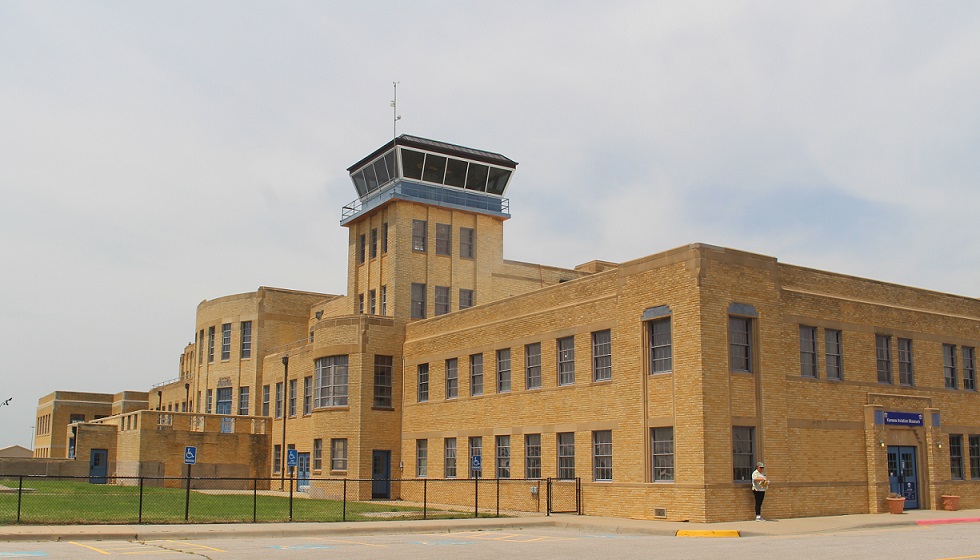
The mid-continent location of Wichita Municipal Airport made it one of the busiest commercial airports in the country: in 1944, a takeoff or landing occurred every 90 seconds. World War II brought significant growth in Wichita’s aviation industry, including a decision by Boeing to build bombers and other aircraft in the city. That expansion, including a new U.S. Air Force base with 6,500 personnel, brought a lot of jobs to the city but it also necessitated relocating Wichita’s airport to a larger facility. By 1954, nearly all commercial and private air traffic was being managed at what is now National Dwight D. Eisenhower National Airport. The original municipal airport facility was used by the USAF and Kansas Air National Guard for a few decades, but the building was eventually abandoned by 1984.
The building and grounds are a perfect location for an aviation history museum, however, and the Wichita Aeronautical Historical Association, leasing the property from the City of Wichita, opened the Kansas Aviation Museum on April 19, 1991. The facility includes a number of large exhibits devoted to different aspects of aviation, including the Engine Room, which displays examples of propellers, landing gear, and engines, many of which were made in Wichita; exhibits detailing the history of Wichita-based aircraft companies like Beech, Cessna, and Ryan International Airlines; and many full-size original private and military aircraft.
Let’s start with a visit to the Engine Room, shall we?

Curtiss OX-5 Engine
This 8-cylinder engine, producing 90 horsepower and 1,400 revolutions per minute, was the powerplant of the Curtiss JN-4 airplane. Known as the “Jenny,” the Curtiss Aeroplane Company developed the aircraft as a trainer for the U.S. Army in 1915. So many pilots learned to fly in the Jenny that it was called “the airplane that taught America to fly.” Curtiss built a total of 6,813 Model JNs, ending production in 1927. The airplane remained very popular following World War I and was heavily used in the barnstorming craze that led to the rise of civil aviation in the United States. This engine weighs 390 pounds, about a third of the Jenny’s total weight of 1,390 pounds. Nancy and I saw a replica of a JN-3 during our visit to Pancho Villa State Park in New Mexico in December 2021. The state park is the site of the former Camp Furlong, at which the first military airfield in the United States was built in 1916;.

Wright Whirlwind J-5 Engine
This important engine was introduced in 1925 to power a number of aircraft built in Wichita, including the Travel Air 2000, 3000, and 4000, as well as the Laird (later Stearman) Swallow (see below). An engine of this type drove the propeller of the Spirit of St. Louis, a custom-built monoplane, across the Atlantic Ocean during Charles Lindbergh’s first solo transatlantic flight in May 1927. The Wright Whirlwind produced 220 horsepower at 2,000 RPM.

1934 Link Trainer AN-T-18
When I first saw this machine from a distance, I thought it was a toy. Edwin Link’s family produced pianos and organs, and Link used that experience with valves, bellows, and pumps to develop this instrument flight simulator. The machine used organ bellows to make the trainer pitch, roll, and yaw in response to a pilot trainee’s movements.

I wasn’t terribly far off from thinking it was a toy, though. The U.S. Army Air Corps didn’t think much of the simulators at first, and the first sales of the trainer came as carnival rides. However, when 12 Army pilots were killed in a 78-day period due to their lack of training in flying under instrument conditions, the Air Corps was compelled to find a solution. In 1934, Edwin Link flew to a meeting in foggy conditions that were perceived as unflyable, and the Army Air Corps ordered its first six Link Trainers at a cost of $3,500 each. During World War II, more than 10,000 Link Trainers were built to familiarize more than 500,000 U.S. Army and Navy pilots with flying under instrument conditions.

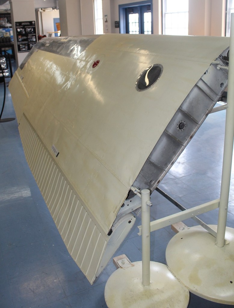
Cessna 206 Super Skywagon Wing
Along with engines and propellors, this section of the museum illustrated how aircraft wings work. The elliptical design of the wing provides lift when the airplane is pulled forward by a propeller or pushed from behind by a jet engine. This is the left wing of a 1964 Cessna 206. The six-seat Super Skywagon was introduced in 1964 and remained in production until 1986 when Cessna ceased production of single-engine aircraft. The company reintroduced the 206 in 1998 and the aircraft remains in production. The 206 model, renowned for its stability and reliability, could carry a thousand pounds of passengers and/or cargo, which led to it being known as “a flying pickup truck.” See below for a picture of a Cessna 206 with both of its wings, along with all its other parts.

General Electric/Allison J35-A-13 Turbojet Engine
In addition to propeller engines, the museum has a good selection of early jet engines. This jet engine was first developed by General Electric in 1946, but the Allison division of General Motors took over production of the engine the following year. More than 14,000 of these engines were built by the time production of the J35 ended in 1955. It was used in a number of experimental aircraft, as well as the production fighters North American FJ-1 Fury, Northrop F-89 Scorpion, and the Republic F-84 Thunderjet (see below). This engine weighs more than 2,800 pounds and produced 5,200 pounds of thrust.
Now, on to the West Hall’s display of vintage aircraft.
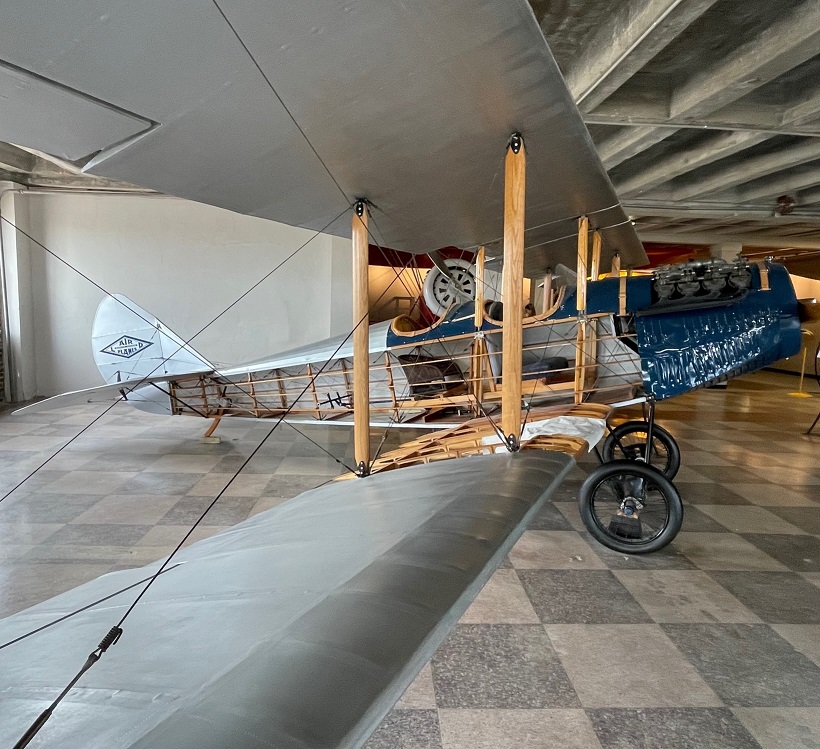
Replica of an early 1920s Laird Swallow
E.M. Laird Airplane Company was formed in Wichita in 1920. The company’s first airplane, the Wichita Tractor, took flight on April 8 of that year, and an onlooker remarked, “She flies like a swallow, boys.” The Laird Swallow was the first commercially produced aircraft in the United States, and only 43 models were constructed. No original Swallows are known to exist, thus this replica (from which the sides of the fuselage have been removed so one can see the inner workings). The Swallow had a top speed of 86 MPH.
An interesting note: a couple of the original principals of the company, Lloyd Stearman and Walter Beech, would later join with Clyde Cessna and Walter Innes to create the Travel Air Company in 1925. Travel Air was the biggest aircraft manufacturer in the United States three years later, and was the prime contributor to Wichita being named the “Air Capital City.”
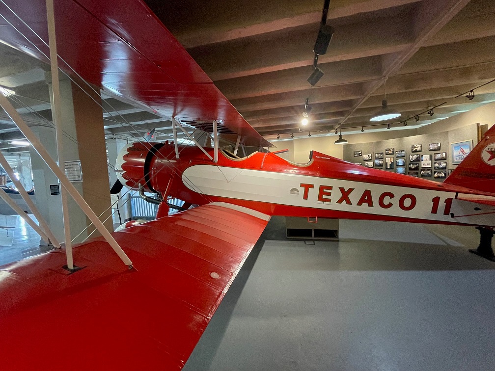
1931 Stearman Model 4D
Developed in 1930 from earlier Stearman designs, the Model 4 was developed with a deeper fuselage and more powerful engine that enabled it to carry heavier cargo loads than its predecessors. This is one of only four Model 4Ds to have been constructed, and a total of 41 Model 4 variants were finished. Stearman Model 4 aircraft were in the fleets of Varney Airlines (now United Airlines), American Airways (now American Airlines), and Standard Oil Company. This particular craft, which sold for about $16,000, was first used by Texaco Oil Company until its retirement in 1936. It was later used for crop dusting, and still later for mosquito control for the Tennessee Valley Authority in Alabama. It had a top speed of 145 MPH and a range of 500 miles, weighing 3,800 pounds. Its wingspan is 38 feet and the length is just shy of 27 feet. The Kansas Aviation Museum completed the restoration of this beautiful airplane, featuring its original livery, in 2014.

1944 Beechcraft D175 Staggerwing
During the U.S. Great Depression, aircraft executive Walter Beech and airplane designer T.A. “Ted” Wells collaborated on a biplane project intended solely for the use of business executives. The Beechcraft Model 17, later known as the “Staggerwing,” first flew on Nov. 4, 1932. The aircraft got its nickname because of the wing configuration: the upper wing was placed behind the lower wing to improve pilot visibility. This aircraft featured retractable landing gear, which was not common at the time, and boasted a range of 670 miles with a top speed of 212 MPH. The wingspan is 32 feet and the craft is almost 27 feet long, with a gross weight of 4,250 pounds. Note that the Wichita Municipal Airport was not originally designed to display aircraft in its interior, and part of the fun of visiting the museum is wondering how the airplanes got into the building for display.
Before going outside to see the aircraft on display out there, take a look at the ceiling above you:

Now, let’s proceed outside for a look at a few of the 14 aircraft on display.

Republic F-84 Thunderjet
Republic Aviation, based on Long Island, New York, is famous for its design and production of several World-War-II-era and post-war aircraft, including the P-47 Thunderbolt fighter, the F-105 Thunderchief, and the F-84 Thunderjet. First flying in 1946, the Thunderjet was plagued by a variety of problems that nearly caused the U.S. Air Force to cancel the program. However, after some significant design improvements, the F-84 became the Air Force’s primary strike aircraft during the Korean War and would fly more than 86,000 sorties during that conflict. The Thunderjet was the first production aircraft to be capable of inflight refueling, as well as the first fighter that could carry a nuclear weapon. The F-84 was also the first aircraft to be used by the Air Force Thunderbirds aeronautics team. More than 7,500 F-84s were built. The General Electric/Allison J35-A-13 turbojet engine, shown above, was used in the F-84. With later variations and improvements in performance, the F-84 could fly up to 622 MPH.
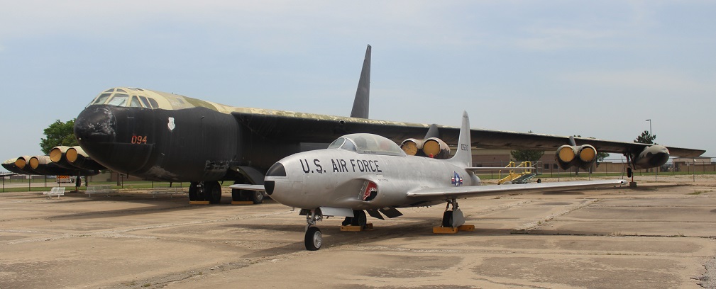
Lockheed T-33B Shooting Star and Boeing B-52D Stratofortress
First flying in 1948, the Lockheed T-33 (shown in foreground) was used by the U.S. Air Force and Navy as a trainer for its jet pilots. More than 6,500 Shooting Stars were manufactured until production ceased in 1959. In addition to the United States, military branches of 43 other countries used the T-33 to train their pilots. The last operator of the T-33, the air force of Bolivia, retired its aircraft in 2017 after having used Shooting Stars for 44 years. The T-33 had a maximum speed of 600 MPH.
You might also notice the Boeing B-52D bomber, the big boy in back of the T-33. Introduced by Boeing in 1952, the jet-powered Stratofortress continues to be in service with the U.S. Air Force and is expected to remain so into the 2050s. It has outlasted more advanced bomber models introduced after it, like the Convair B-58 Hustler, the Rockwell B-1 Lancer, and the Northrop Grumman B-2 Spirit. Originally manufactured in Boeing’s Seattle plant, the B-52 was built in Wichita beginning with this B-52D model in 1957 and continuing through the B-52H model in 1963. A total of 742 B-52s were built in Seattle and Wichita, and about 50 of them are still in service. Powered by eight Pratt & Whitney turbofan engines, the final B-52H production model has a maximum speed of 650 MPH, a service ceiling of 50,000 feet (nine and a half miles above the Earth) and a ferry range (when fully loaded with fuel) of just over 10,000 miles and a combat range (while carrying ordinance) of 8,800 miles. For reference, the diameter of the Earth at the equator is 7,917 miles. With a wingspan of 185 feet, as Nancy pointed out, if a B-52 was parked so that its nose was on the 50-yard line of a football field, its wings would stretch to each of the 20-yard lines (as a comparison, a Boeing 737 passenger airliner has a wingspan of about 117 feet).

Boeing B-47 Stratojet
We saw an example of this bomber in Albuquerque, New Mexico, during a visit to the National Museum of Nuclear Science & Historyin late 2021, but it was fun to see this aircraft on display in the city in which, like the B-52D above, it was built – the first B-47 was manufactured in 1951, in Wichita. The B-47 was the U.S. Air Force’s first swept-wing bomber capable of flying at both high altitude and supersonic speed, with a maximum speed of 607 mph and a ferry range of more than 6,400 miles. When you fly on a commercial jet airliner today, you’re benefiting from technology and aeronautic advancements that were first made with the development of the Stratojet.

Cessna 206
It’s really rewarding to see examples of Wichita-made military aircraft that, in addition to helping protect our country, led to the development of so many aeronautical innovations we take advantage of when taking a cross-country (or cross-ocean) flight. For me, however, whenever I think of Wichita aircraft companies, my mind first goes to Cessna. My dad, Steve Goering, was born and raised just north of Wichita and got his private pilot’s license as a very young man. He has piloted Cessna models 150, 170, 172 and 182, along with a number of other fixed-wing aircraft and helicopters. This is an example of a Cessna 206, an extraordinarily popular model of aircraft (along with the models 205 and 207) that is used for commercial air service as well as personal use such as aerial photography.
Cessna was founded in Wichita in 1927 by Clyde Cessna and a partner, who quickly sold his share of the company to Cessna. The company was purchased by General Dynamics in 1985, and then by Textron in 1992. It, along with Beechcraft and Hawker Aircraft companies, is now a brand of Textron.
We’ve been to a number of aircraft museums in the months since becoming full-time RVers, but the Kansas Aviation Museum sticks out for me simply because of the history that the city of Wichita has with the science of flying. Its displays will teach you how airplanes fly, either with engine-driven propellers or with jets, and provide you with up-close views of some of the most popular aircraft produced — many in Wichita — in the last 100 years. Seattle, Washington, can certainly be proud of its aviation history as well, but I don’t think there’s a museum showing the depth of home-grown aeronautical innovation – from this Cessna 206 to a Boeing Stratofortress – quite like Wichita’s.

One day – I think it was a Tuesday but I could definitely be wrong – about 35 million years ago, a volcano began erupting in what is now southwestern New Mexico.
Somewhat later, on January 8, 2023, Nancy, Gunther and I visited City of Rocks State Park, located about 20 miles south of the caldera that produced the eruptions. The pumice and other rocks produced by the volcano’s eruptions 35 million years ago form the main feature of the state park, which also has a number of interconnected hiking trails, developed campsites, a botanic garden, and even an astronomical observatory.
We’d planned to visit he park, which is located halfway between Deming and Silver City, New Mexico, just a few miles east of U.S. Route 180, several times in 2021 and 2022 when we were camping in Deming and Silver City. However, the 35 mile-per-hour winds each of those days convinced us to find something else to do. The morning of January 8 was bright and calm, and we made the short trip to the state park. We’re all glad that we did.

You’ll find plenty of prickly pear cactus at City of Rocks State Park in New Mexico, along with a wide variety of other plants. In the background, a vehicle provides a sense of scale for the namesake rocks near the park’s visitor center.
The park, at an elevation of just over 5,200 feet, gets its name from several tall outcroppings of rock that have eroded over the past 35 million years into pinnacles and other formations, separated by lanes that resemble city streets between tall buildings.

Here we see an amateur geologist, with her professional dog, on one of the park’s trails. They appear to be in disagreement about which direction to proceed. The park has about five miles of trails, some of which wind directly through the rock formations. Many of the pinnacles are 40 feet tall.
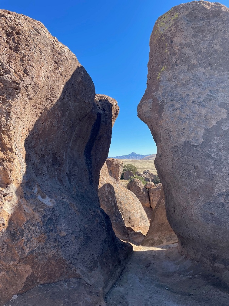
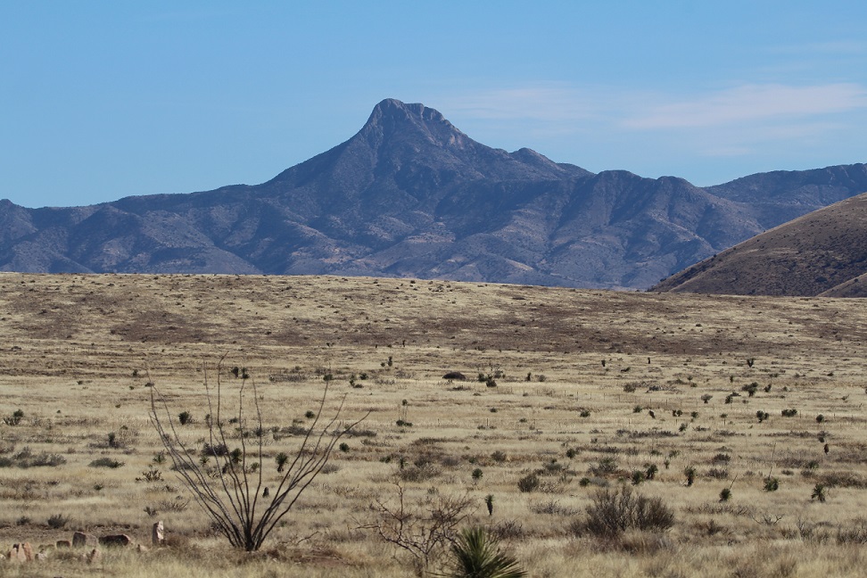
Paths between the rocks can get pretty tight. During the main phase of the volcano’s eruption, more than 240 cubic miles – about twice the volume of Lake Erie – of pumice and ash were ejected. This eruption also resulted in the “Kneeling Nun” formation east of present-day Silver City, 20 miles to the north. The pointed mountain seen between the two rocks is Cookes Peak (elev. 8,408 feet), a significant landmark in southwestern New Mexico. The mountain is directly north of the city of Deming.
The volcanic eruption that formed the formations of City of Rocks likely lasted several years and was about a thousand times larger than the Mt. St. Helens event in Washington on May 18, 1980. The eruption blanketed this area in a deep layer of hot ash and pumice. As those volcanic materials cooled into a rock called tuff, it shrank somewhat and vertical cracks in the stone were created.

They still haven’t agreed on a direction in which to hike. The park has a huge variety of succulents, like the soaptree yucca at the left of the trail, as well as many grasses common to the southwestern United States.
Over the last several tens of millions of years, the erosive forces of nature – water, wind, and organic growth – broadened the small fissures between the rocks into larger and larger crevices until the natural pathways seen today were created.

Now they’re both headed the same direction. The amateur geologist is standing in a crevice that is a conduit for water flowing through the rock formation. It’s that water, which carries abrasives like sand, that helped carve the rocks into the shapes we see today. Other contributors to the erosion include wind, which can also carry sand, as well as plant (and non-plant) life and the cycle of freezing and thawing water.
Many different groups of native Americans have lived in, or at least passed through, the area now known as City of Rocks. About 12,000 years ago, the last of the Ice Age glaciers were retreating and large mammals like mammoths and mastodons roamed this region. It’s likely that Paleoindians, like Clovis or Folsom peoples, hunted the large animals. Between 8,000 and 1,000 years ago, small bands of the Desert Archaic culture lived in the area and, toward then end of that era, began to build pit houses. Finally, the Mimbres culture occupied the area between the years 200 and 1150 AD. In addition to hunting animals and gathering food from plants, the Mimbres cultivated crops like beans, squash, and maize. They also built one-story above-ground dwellings.
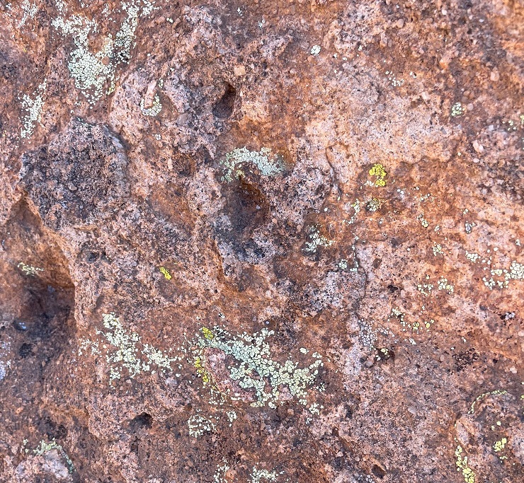
Do you like lichen as much as I’m likin’ this lichen? There are about 20,000 known species of lichen in the world, and at least four of them can be seen in this photograph. Lichen, which is plant-like but not an actual plant, contributes slowly but significantly to the erosion of rocks by chemically degrading the stones’ minerals. The scientists estimate that between 6-8 percent of the earth’s land surface is covered by lichen. Actual plants, like succulents, grasses and shrubs, also contribute to erosion by their seeds finding purchase in small crevices in the rock and then, as the plants mature, the growing roots of the organism can cause further fracturing of the minerals.

Getting up-close and personal with the rocks allows one to see some pretty fascinating natural patterns caused by erosion. I sure hope that whoever dropped those keys comes back by to pick them up! (Just kidding – they’re mine. Still need to go back and pick them up.)

Because the park is 25 miles from the nearest city of any size, it’s a popular site for stargazing at night. This structure is an astronomical observatory located near the main campground in the park. The roof slides back onto the supports in the back to reveal the telescope. It was not in operation during our visit (as you can see, it was daylight), but the park does host regular star parties during which the observatory is open and other amateur astronomers bring their own telescopes to share views of the night skies.
This magnificent succulent specimen, about 20 yards off the trail, is desert spoon (Dasylirion wheeleri). I didn’t want to get off the trail to take a closer picture, so this will have to do. The fronds of desert spoon were used by native Americans to weave baskets and mats, and its inner core can be fermented into an alcoholic drink, similar to tequila, called sotol. It is found in southern New Mexico and Arizona, as well as parts of Texas and Mexico. The plants themselves grow to about 5 feet tall, but the flowering spike can soar 16 feet into the air.
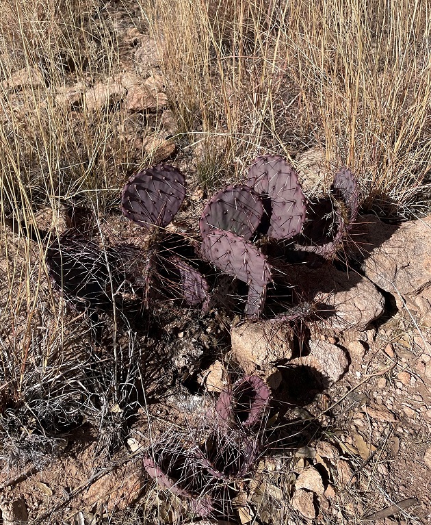
Here’s another interesting succulent found along the trail. This long-spined, purplish prickly pear is called long-spined purplish prickly pear (really) (Opuntia macrocentra). It, too, is found in Arizona, New Mexico and Texas, along with Mexico. Like other prickly pears, the fruit of this cactus is edible and is enjoyed by animals and humans alike.

But it wasn’t simply succulents we saw – we also spied several species of sparrows! Here’s a chipping sparrow (Spizella passerina) perched in some mesquite. We’ve enjoyed seeing plenty of these pretty little birds in southern New Mexico this winter.
While most of the pictures in this posting were taken with the camera on my phone, I used my digital camera to take this photo of Cookes Peak. The tall spindly shrub in the lower left corner is ocotillo (Fouquieria splendens), which can grow to more than 30 feet in height. It is native to the Chihuahuan and Sonoran deserts in the United States and Mexico. Native Americans used different parts of the plant to address a variety of ailments, and ocotillo can also be planted to serve as a natural fence.

A short spur off the main trail took us to the top of a 300-foot hill that provided a tremendous 360-degree view of the area. In this photo, the rock formations of City of Rocks are in the midground (the white streaks above the center of the photograph are campers’ recreational vehicles parked amongst the rocks, and the light brown building to the left of the RVs is the park’s visitor center). The tallest mountains on the left horizon are the Cobre Mountains, 16 miles away, and the Pinos Altos range, 30 miles in the distance, is just to the right of the Cobre Mountains.

This eye-catching grass is cane bluestem (Bothriochloa barbinodis), a valuable forage for ranchers but one of the first grasses to disappear if a pasture is overgrazed. The seed heads catch the sun in such a way as to look absolutely illuminated from within.

When we walk by a creosote bush (lower left), I like to rub my fingers on the leaves – they smell just like the air outside after a rainstorm. Along with seemingly every other plant, Native Americans found many medicinal uses for creosote. In the background is Table Mountain, the tallest point in City of Rocks State Park. The distinct layers of rock seen on the mountain’s slopes are due to different volcanic ashflows more than 30 million years ago..
If you plan to visit City of Rocks State Park, you’ll want to do make plans to do so soon-ish. The erosional forces that created the cracks between the rocks continue to degrade the stones even today (I mean, you saw all the lichen), and in several million years the whole area will just be flat.
Nancy and I definitely enjoyed our time in the park – it was a lovely day, with highs in the low 60s and very calm breezes, and the 4-mile hike gave all of us some great views and good exercise (Monday, January 9, was a day of relaxation and recuperation for Gunther). We plan to take the Goddard to the park in the next few years for some actual camping – it has more than 40 developed sites – and it has some other trails that we haven’t yet enjoyed.

In addition to the Cosmosphere, a world-class space science museum, the city of Hutchinson, Kansas, features another prominent attraction: the only salt mine in the country that’s open to the public. Have I got your attention yet? Read on!
Formerly known as the Kansas Underground Salt Museum, Strataca is owned by the Hutchinson Salt Company, which began operations in 1923 as the Carey Salt Company. Nancy and I visited Strataca in late May 2022.
The salt extracted from the mine is not the type that you’ll find in your kitchen salt shaker. There are a number of impurities in the mineral, which makes it ideal for managing icy roads and for feeding livestock.
Strataca’s story begins, as do all of the good ones, in the late part of the Paleozoic Era, known as the Permian Period, about 275 million years ago. Kansas, along with much of the rest of present-day North America, was covered by a vast inland sea. The waters eventually receded, leaving behind an immense deposit of salt that, over tens of millions of years, was covered with layers of shale and other sediments like sand, gypsum, and silt. That 275-million-year-old deposit of salt is now 650 feet below the Kansas prairie.

The museum has been at this location on the east side of Hutchinson since 1986. Of the 15 salt mines in the United States, Strataca (née the Kansas Underground Salt Museum; the name was changed in 2013) is the only one that is open for visitor tours. I’m trying to remember to take pictures of the exteriors of the museums we see; it seems that the American flags are flying at half-mast more often than not. We visited Strataca on Memorial Day.
A double-deck elevator takes two sets of up to 15 people each on a four-minute trip 650 feet down into the bowels of the earth. (It’s not really the bowels of the earth; the top crust of the earth, which makes up about 1% of the radius of our planet, has an average thickness of nine to 12 miles. In other words, the 650-foot elevator ride takes visitors down about 1% of 1% of the earth’s radius. Still, the elevator ride is pretty neat!)
Excavating the shaft for this visitor elevator was no mean feat. In addition to penetrating hundreds of feet of sedimentary rocks, the shaft also had to descend through part of the Ogallala Aquifer – one of the world’s largest natural underground reservoirs. The aquifer is about 130 feet thick at the site of the museum. To construct the shaft, engineers used liquid nitrogen to freeze the area of the aquifer immediately surrounding the planned shaft, then excavated the ice and replaced it with a concrete liner. The process was completed in 15-foot increments, and took just over a year between March 2004 and March 2005.

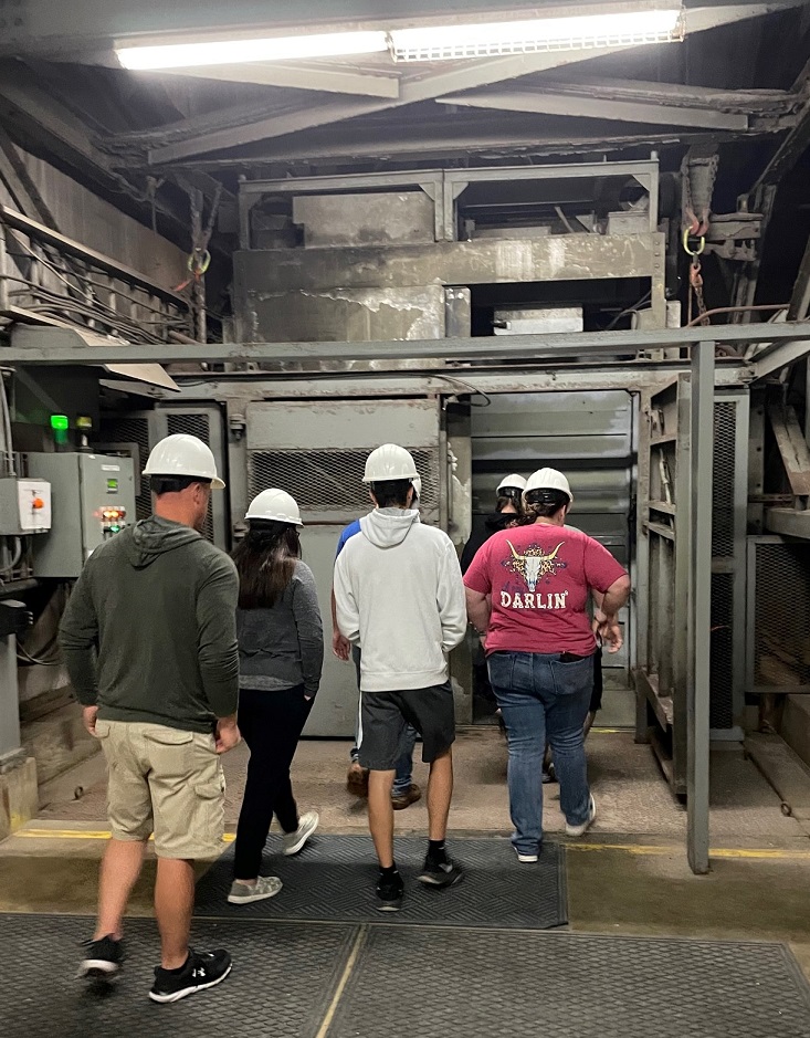
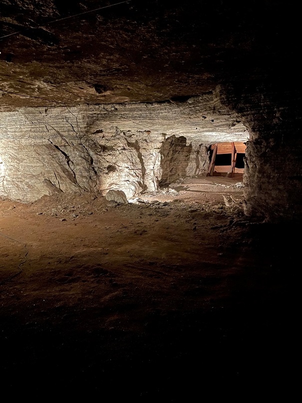
Upon exiting the elevator, visitors enter a large chamber filled with interesting exhibits that tell the wondrous story of sodium chloride (NaCl). As you can see, every visitor has to wear a hard hat. I jostled my way to get a blue one. The temperature in the mine year-round is 68 degrees Fahrenheit, with a relative humidity of 45%.

Let’s go back topside for a moment. This map, located in the museum’s visitor center, shows the extent of the mine (in yellow) with the rest of the city of Hutchinson to the west (left). The 1.5-square-mile mine is immense; if each of the excavated areas was lined up in a straight line, the chamber would extend for 150 miles. Pillars of solid rock salt, 40 feet square, are left to separate each chamber and support the upper level of salt.

Okay, back down into the bowels of the earth 650 feet below the surface. Here’s a closeup of the salt deposit. As you can see, it’s quite different from the Morton’s that’s in your kitchen cabinet. The sodium chloride is mixed with a number of other minerals, including shale and sulfur compounds, which is why it’s primarily used to de-ice roadways.
The year 2023 will mark a century of mining by the Hutchinson Salt Company (formerly Carey Salt). It mines in the room and pillar process. This involves excavating, with the use of explosives, large chambers alternating with square pillars, measuring 40 square feet, that support the upper level of the mine. The process results in something of a checkerboard pattern, if it could be viewed from above. The mine’s chambers are very large, ranging from 2,500 to 15,000 square feet in size, with ceiling heights of 11 to 17 feet. The room and pillar method differs from traditional precious metal mining, in which miners follow the vein of gold or silver ore, for instance (unless it’s more cost-efficient to simply take an entire mountain apart, which seems to be happening more often).

Strataca has retained a lot of Carey Salt’s equipment from the early days of the mine (I’m guessing partly because it would cost time and money to return them to the surface, but it’s still fun to see the specialized equipment). The machinery is fairly well-preserved, considering the relatively high humidity; the salt can’t be good for metal parts, though. This machine was used to cut long slits at the bottom of a salt wall; when explosives in the wall were detonated, the slit ensured that the salt fragments fell forward into the chamber.
The excavation takes place in much the same way today, but using modernized equipment. The rock salt fragments are transported via conveyors to crushers, then taken to the surface using large buckets on a hoist. When operating at capacity, the skip, or mine elevator, can carry four tons of salt to the surface every three minutes. The skip is also used to transport miners into and out of the operation. Miners formerly used a rail system to move about the operation underground, but have since started using old junk cars that have been modified to run on bio-diesel fuel. Developed almost entirely from old cooking oil, the burning of bio-diesel doesn’t leave particles suspended in the environment. There are many instances of several generations of Hutchinson families being employed by the mine.

This was an interesting exhibit; it’s essentially a waste dump site. Early in the mine’s history, employees would leave their empty food packaging underground because it was more cost-effective to use the skip to transport either rock salt or miners. The salty environment, well away from the sun’s ultraviolet rays, has preserved the trash remarkably well; a lot of the sandwich wrappers and empty drink cups look like they were tossed aside last week instead of in the 1950s.
Nancy and I went on a couple of different guided tram rides through the mine. We got to see chambers that were excavated decades ago, using earlier mining methods. The mining company has placed a number of environmental sensors throughout the operation, which provide early detection of any possible shifting of the rock salt walls. The Mine Safety and Health Administration, which oversees operations in U.S. mines, considers this salt mine one of the safest in the world.

Nancy really enjoys being underground. I mean, really. She’d been looking forward to visiting the Hutchinson salt mine for a number of years, and we both had a great time. Luckily for us, our underground adventures were only beginning – we’d be able to descend into the bowels of the earth natural caves at two U.S. national parks in the months to come. Multiple times at each cave, even!
A salt mine might seem like something of a “so what?” kind of experience. But it’s the salt that comes from this mine, and others like it, that keep our roads safe to drive in wet and freezing weather. We’re glad we went, and, combined with the Cosmosphere, Strataca makes an excellent reason to visit Hutchinson.

(Editor’s note: alert readers may note that I haven’t posted any updates on this blog for several months. We did lots of things between visiting the Barbed Wire Museum in May and White Sands National Park in November, but I’m going to post this now and fill in the months in between.)
On Thanksgiving Day, Gunther and Nancy and I went to White Sands National Park. It’s near the town of Alamogordo (Spanish for “fat cottonwood”), New Mexico, where we camping for a week. We were a bit surprised at the number of people who’d also chosen to visit the park on Thanksgiving, but, judging from the languages and accents we heard, we think a lot of them were tourists from Japan.
White Sands was first declared a national monument in 1933 and was re-designated as a national park in 2019. Nancy and I visited the then-monument during a trek through New Mexico in 2015, but were happy to share the experience again with Gunther. White Sands is the most-visited of the two national parks in New Mexico; a typical year sees 600,000 people stroll, slide, stumble, and tumble down its dunes. During the last two years, the pandemic increased that visitation to more than 700,000 visitors annually. (Carlsbad Caverns National Park, the state’s other national park, receives about 440,000 visitors each year. Two of those were Nancy and me; more to come on that.)
White Sands National Park is on the northern edge of the Chihuahuan Desert, which encompasses about 175,000 square miles. This desert, the largest in North America, stretches 1,200 miles from Alamogordo southward well into Mexico.
We took a walk on the park’s Interdune Boardwalk, which provides a lot of introductory information about the park’s ecosystems, and then hiked a two-mile loop in the dunes themselves along a marked trail where backcountry camping is permitted. There’s not a path in the dunes; the wind would scour away any trail in the sand within a couple of days. Instead, the route is marked with tall posts.
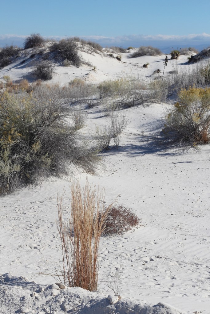
That’s a grass known as little bluestem (Schizachyrium scoparium) in the foreground. Little bluestem is very common throughout the Great Plains and the intermountain west, and can survive in the desert here at White Sands National Park because the water table is typically only two or three feet below the surface. While on our hike, we noticed that the sand between the dunes was actually pretty wet. The Tularosa Basin, which includes the town of Alamogordo as well as the national park and White Sands Missile Range, is bordered by the Sacramento Mountains on the east (in the background of this photo) and by the San Andres and Oscuro mountain ranges on the west. The Tularosa Basin is about one-third larger than the state of Connecticut.
Some more rather staggering numbers regarding White Sands National Park: the sand has an average depth of about 30 feet, some of the dunes are 60 feet high, and the scientists figure that the dunefield contains about 4.5 billion tons of sand.

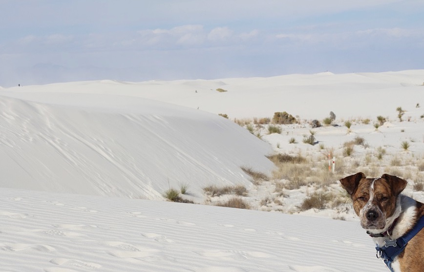
This photo, taken from the passenger seat of the Goddard’s six-wheeled towing unit, shows not snow, but sand. White Sands National Park features the largest gypsum dunefield in the world: at 275 square miles, it’s so big that it can be seen from space. (Great Sand Dunes National Park in southern Colorado measures about 30 square miles and contains several different minerals.) Only about 40 percent of the White Sands dunefield is in the national park; the rest is in the U.S. Army’s White Sands Missile Range (WSMR), which surrounds the park, and is strictly off-limits to the public. WSMR has an area of 3,200 square miles and is the largest military installation in the United States (it’s 32% bigger than Kit Carson County in eastern Colorado). The national park is occasionally closed to visitors because of missile testing on the range. The world’s first atomic bomb, Trinity, was detonated on the northern edge of the missile range on July 16, 1945, as a test prior to the United States releasing atomic bombs in Japan to bring World War II to an end.

Here we see a visitor to White Sands National Park and her ill-behaved dog (it’s Nancy and Gunther) on the Interdune Boardwalk, a short elevated trail with many exhibits along the way. A good variety of desert plants, including shrubs, grasses, and cacti and succulents, thrive in some parts of the dunes.

The sand is remarkably white, and remarkably fine – most of the grains are smaller than crystals of table salt or sugar. Where did all of the sand come from? The answer lies, as many do, with the fact that this part of the planet was covered by a vast inland sea during the Permian Period (about 300-250 million years ago). The waters eventually evaporated away and left immense deposits of gypsum (also known as the mineral calcium sulfate) in the former seabed. Tectonic activity then uplifted the mountain ranges on either side of today’s Tularosa Basin. Over tens of millions of years, rain slowly dissolved the gypsum deposits in the mountains and ancient rivers carried the minerals to today’s White Sands National Park. The dunefield is relatively new, geologically speaking: it’s only 10,000 years old.
Gypsum has a number of beneficial uses for humans: it’s the prime component of drywall, which is used in building construction, plaster of Paris, and toothpaste. It’s also found in all kinds of food, including canned vegetables, white flour, ice cream, and in the production of both beer and wine; people ingest almost 30 pounds of gypsum during their lifetimes.
The mineral’s usefulness led to the designation of White Sands as a national monument in order to protect the area, and its plants and animal ecosystems, from commercial development.
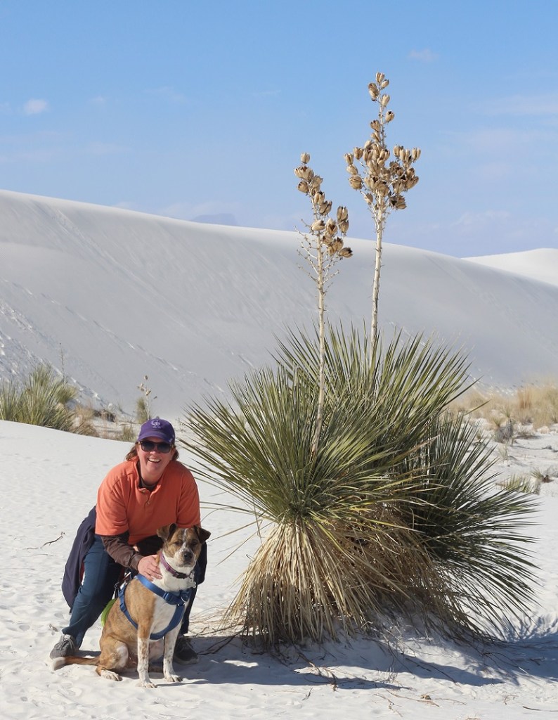
Soaptree yucca (Yucca elata) is a really interesting desert succulent. Native Americans had more than 100 uses for the plant, including as a source of food, fibers for the manufacture of textiles, and true to its name, soap. The stem of the soaptree yucca, which grows underneath the sand, can be many times longer than the height of the plant above ground. As sand moves and threatens to cover the plant, the soaptree yucca continues to elongate its stem so that the plant’s photosynthesizing leaves stay above ground.

The seed pods of soaptree yucca (shown here in their dried form at the end of November) had many uses for Native Americans, and they’re also important to the desert ecosystem. The park is home to 800 different animal species, 650 of which are moths. Thirty-five of the moth species are found only at White Sands. Several different types of moths are responsible for pollinating the soaptree yucca, and they also lay their eggs in the flower pods.

One thing the scientists don’t know is why Gunther enjoys running on the sand so much. He did this at Great Sand Dunes National Park in Colorado, and he’s done it on beaches at reservoirs and lakes. He’s kind of a nut.
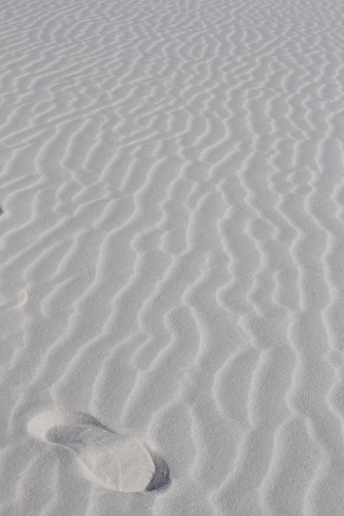
The wind carves the sand on the dunes into all kinds of interesting patterns of ripples, shifting nearly imperceptibly but constantly with every gust. I included the footprint in this crop of the photo to provide some scale; who knows who left it, and how many thousands of years has it been imprinted in the sand? (I left it, about five seconds before taking this photo.)

Here was a fun little surprise: I wasn’t expecting to find rubber rabbitbrush (Ericameria nauseosus) in the desert sand, but here it is. We planted several of these at our home in Denver, and they were hosts to hundreds and hundreds of bees, along with lots of butterflies, during their late summer blooms. Rabbitbrush’s pollen is important source of food for butterflies during their migration. Native Americans used the yellow pollen to dye textiles, and they used other parts of the plants to make baskets and arrow shafts.
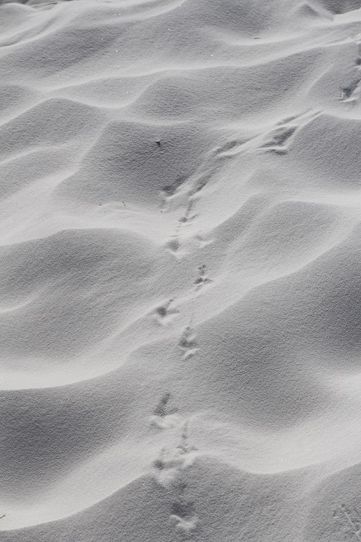

We saw a few invertebrate species of animals, including some beetles, but we didn’t see any mammals during our hike in the dunes. The park is home to American badgers, coyotes, black-tailed jackrabbits, desert cottontails, bobcats, and several different rodents. Most of the larger animals beat the heat by being nocturnal: staying in their burrows until nightfall. I think some kind of bird left the tracks on the left, and I’m fairly certain the photo on the right shows tracks from a northern Chihuahuan desert wolf. (I’m just kidding with you right now; they’re Gunther’s.)
The northern Chihuahuan desert wolf Gunther stopped running around long enough for me to take this picture on our two-mile hike on the dunes. The lower areas between the dunes provide a sheltered and well-watered place for plants to grow. The black dot at the top of the dune on the left side of the photo is another hiker.
White Sands National Park is an incredible treasure. A short hike up a 60-foot sand dune rewards one with a wonderful view of mountains, sky, and … more sand dunes. Nancy and I wondered, while on the two-mile hike, what it would be like to camp on the dunes. It would probably be an eerie experience — quiet except for the wind and occasional coyote yip. The stars would be beyond beautiful at night, though – something to consider for another trip to the park.

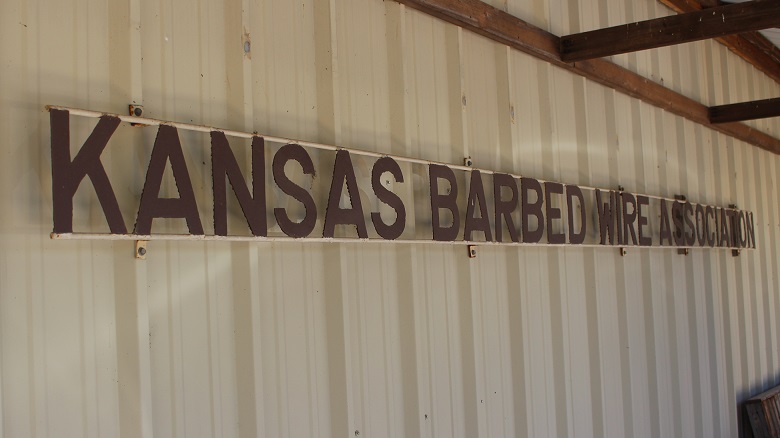
It’s bold to call a town the Barbed Wire Capital of the WorldTM, but that is indeed what La Crosse, Kansas does. The designation came about because of another of La Crosse’s claims to fame: it’s the home of the Post Rock Museum. But before we get into post rocks, let’s go back to barbed wire (if you really want to read about post rocks, scroll down to the bottom of this post but you’re going to miss out on the truly exciting barbed wire content). In the early 1960s, volunteers at the Post Rock Museum noticed that a large number of visitors took special notice of the small barbed wire exhibit.

In response to that interest, in 1966 a group of La Crosse businesspeople formed the Kansas Barbed Wire Collectors Association. As with any association, it conducted an annual event: the first Barbed Wire Swap and Sell Convention occurred at the Rush County Fairgrounds in May of the following year. More than 2,000 barbed wire collectors and enthusiasts attended the show. La Crosse has since hosted the event each year (the 2022 festival was May 5-7) and that’s one way you get to be called the Barbed Wire Capital of the WorldTM.
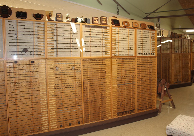
Another way is to develop a museum. The first building that housed the Kansas Barbed Wire Collectors Association’s collection of barbed wire and associated materials was a small structure on Main Street in La Crosse. The museum was dedicated on April 30, 1971; the day included a parade as well as appearances and remarks from various local and state dignitaries. The 500-square-foot building was home to displays of 500 types of barbed wire, tools, and other artifacts, the majority of which came from the collections of two Kansas men, Leo Schugart of Hoisington and Don Wigington of Quinter.

Alas, less than two decades passed before the museum had outgrown the Main Street building. The La Cross chamber of commerce commenced a fundraising campaign to construct a new building, measuring 5,400 square feet, in the town’s Grass Park. The new facility, built in a year, was dedicated on May 4, 1991. The Kansas Barbed Wire Museum, which is owned and operated by the Kansas Barbed Wire Collectors Association, is also home to the Antique Barbed Wire Society’s Historical Research Center as well as its Hall of Fame. The museum welcomes visitors from around the globe each year.
Two of those visitors this year were Nancy and me, in late May. Nancy, recognizing my enthusiasm for barbed wire exhibits during our travels (we’ve seen an impressive number of exhibits in city museums in New Mexico and Arizona), surprised me with an early birthday gift of a visit to the museum. At the time, we were camping in Hays, Kansas, which is located about 25 miles due north of La Crosse. For those unclear or simply unaware of where Hays is, it’s about 160 miles east of the eastern border with Colorado, conveniently located in the north-central part of Kansas on Interstate 70.
You might be asking yourself: “Why is there a museum dedicated to barbed wire?” It’s a fair question, I suppose, and for the answer we must go back to the formation of the North American continent and its place on the earth. Imagine a vertical line hugging the eastern borders of North and South Dakota, continuing south near the eastern border of Nebraska, and then across the eastern thirds of Kansas, Oklahoma, and Texas. That line is the 98th Meridian, meaning that it’s 98 degrees (out of the globe’s 360 degrees) west of the Prime Meridian at Greenwich, England (all meridian lines extend north and south to the poles of the earth). The 98th Meridian is significant because most all of the land in the United States west of that line (with the exception of the Pacific northwest and the west coast) gets less (and some get much less) than about 20 inches of precipitation each year, and everywhere east of that line receives more than 20 inches. To compare five cities in which we’ve recently been:
| City | Meridian | Annual inches of precipitation |
| Tucson, Arizona | 111th | 10.6 |
| Denver, Colorado | 105th | 14.3 |
| Hays, Kansas | 99th (one degree west of the 98th) | 23.8 (plus an additional 13.9 inches of snow) |
| Memphis, Tennessee | 90th | 53.7 |
| Detroit, Michigan | 83rd | 34 (plus an additional 33 inches of snow) |
There are altitude-based and other geographic exceptions to the annual precipitation amounts, of course: a mountain town in Colorado such as Ouray, in the San Juans, can receive 20 or 24 inches of rain and almost 12 feet of snow each year. The point is, there are some places in the United States that are better suited to growing moisture-dependent crops such as, say, corn than others.
In the last year of being on the road, Nancy and I have experienced single-event rainstorms in Arkansas and Indiana that would have provided a third of Denver’s annual precipitation. That arid nature of the western United States results in different types of flora (such as buffalograss and saguaro cacti) and fauna (such as desert bighorn sheep and horned lizards), and, to get back to the subject of barbed wire, much fewer trees.
East of the 98th Meridian, trees are pretty common thanks to the arable soils and relatively high levels of precipitation. Because of their ready availability, trees provide wood with which to build fences to contain livestock and protect crops. However, in the high plains of the west, most trees grow naturally only along waterways like year-round rivers or seasonal creek beds; many of those trees, like cottonwoods and mesquite, are not anything with which you’d want to build a house or even construct a livestock fence.

While it doesn’t support any real kind of tree growth, the Great Plains does have a great variety of other plants. The native grasses of the prairies west of the 98th Meridian developed deep-growing roots in order to reach reserves of moisture in the soil. In addition to keeping the soil from blowing away during wind events, the grasses wouldn’t turn over easily with farm implements developed for eastern croplands. Further, those native plants had evolved to need much less moisture to survive than did crops such as wheat and especially corn that grew readily in the eastern United States.

Some of the earliest expeditions by the U.S. Army into what is known today as the Great Plains showed that the land probably wasn’t fit for much at all. In an 1810 journal recounting his adventures in the U.S. West, First Lieutenant Zebulon Pike wrote “these vast plains of the western hemisphere may become in time (as) equally celebrated as the sandy deserts of Africa.” Major Stephen H. Long, who traveled more than 26,000 miles in five expeditions across the West, in 1820 called the area “a great desert,” which later led to the term “the Great American Desert.” The plains area from present-day Nebraska south to Oklahoma was, according to Long, “unfit for cultivation and of course uninhabitable by a people dependent on agriculture.”

The passage of time shows that both Zebulon Pike and Stephen Long were wrong* about the prospects of people living in the High Plains. However, it took unimaginable hard labor, perseverance, and technological breakthroughs, in addition to that passage of time, to prove them incorrect. In 1820, the entire United States had a population of less than 10 million. Today, more than 14.5 million people live in the states of Nebraska, Kansas, Oklahoma, and Colorado. The Front Range of Colorado, which stretches from Pueblo in the south to Fort Collins in the north, has a population of more than 5 million people alone [and the Front Range also has views of two of Colorado’s most prominent mountains, Pikes Peak (elev. 14,115 feet) and Longs Peak (elev. 14,259 feet); I don’t know why the names don’t have possessive apostrophes, but these namesakes show that you can get mountains named after you even if you’re wrong].
*Actually, I don’t know that Pike and Long were entirely wrong. At least along the Front Range, that population of 5 million people is largely possible only by water being brought from somewhere else: snow runoff in western Colorado rivers that’s diverted under the Continental Divide to the Front Range, and water being pulled from the underground Denver Basin aquifer through wells. States downstream from Colorado are making increased (and, to this point, entirely legal) demands for Colorado’s western slope water, and the Denver Basin took tens of thousands of years to fill but is now being further depleted every year. Many farms in eastern Colorado and western Kansas and other parts of the area irrigate their corn (the crop doesn’t have much of a chance of success in the Great Plains without irrigation) with a lot of water pulled from the Ogallala Aquifer, which is being similarly and rapidly depleted, without a possibility of being refilled on a human timescale.
But I digress. Back to barbed wire. The 98th Meridian, then, served as a kind of barrier to westward expansion of the United States during and after the U.S. Civil War. The native grasslands were too tough to efficiently plow for use as cropland, and there was no guarantee that there would be enough precipitation to help crops survive even if their seeds could be planted. Add to that the fact that there was very little lumber for building or burning, and it was a land most inhospitable for development.

What was the land, which supported at the time only a number of nomadic Native American tribes that hunted immense herds of bison and other native animals, good for? Well, some folks decided it could support cattle. Between 1866 (the year after the Civil War ended) and 1880, nearly 5 million head of cattle were driven from Texas north into Kansas and beyond for transport by railcars back east.

Along the way, some cattle were sold to ranchers in Texas, as well as present-day Oklahoma, Kansas, and other states. Those cattle helped establish ranches that, in a few cases, are still around today. The Homestead Act, signed into law in 1862, brought droves of people to the west with the intent of acquiring free land upon which they could build homes and develop farms. Moreover, the railroads, in addition to transporting cattle east, brought more people from the eastern United States to the west where public sentiment thought it increasingly likely that livings, if not fortunes, could be made – despite the treeless aspect of the plains.
Those eastern sentiments, such as putting up fences to protect their crops and livestock, conflicted with the open range rights that the cattlemen enjoyed. However, the plains still weren’t any good at providing trees with which one could make fences. Until farmers could cost-effectively keep free-range cattle from tromping their crops and their own livestock from wandering away into the vast expanse of the plains, there was no way for livings to be made. That changed on November 24, 1874, when Joseph Glidden was awarded a patent for barbed wire.
Glidden (January 18, 1813 – October 9, 1906) was an Illinois farmer (I’m writing this blog posting at Kankakee River State Park in Illinois, about 90 miles southeast of Glidden’s farmstead in DeKalb) who developed one of the first methods of mass-producing barbed wire using a coffee mill to create the preliminary experimental barbs. With another twisted wire keeping the barbs in place, Glidden developed “The Winner,” which he considered his best design effort and for which he received the U.S. patent. The development was an immediate success and quickly found its way west, where, since much less wood was needed to build fences, it ended the open range era of the American west and it turned the Great Plains into innumerable pastures. When he died in 1906, Glidden was one of the richest men in America.
Today, drive along any road – multi-lane paved Interstate highway or dusty gravel byway – in the West and you’ll likely see galvanized steel barbed wire fencing that can stretch for miles on into the horizon. It’s cheap, durable, and relatively simple to install, without the use of much wood (except where there isn’t any wood; see below).
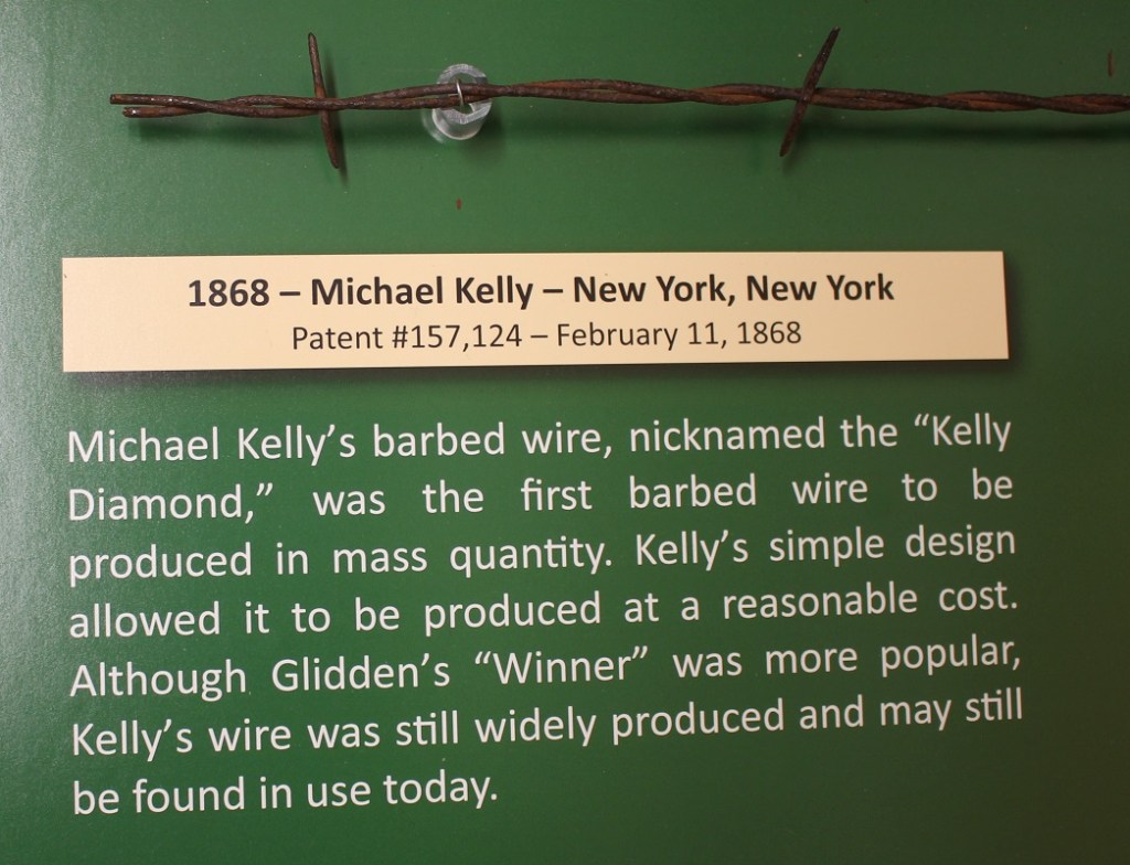
Glidden’s “The Winner” wasn’t the only barbed wire design, and many before and many after him developed their own styles that they thought would work better in certain situations or environments. Those hundreds of other barbed wire designs, all with the intent of keeping animals in (or out) of a certain area, kept and continue to help keep Americans and the world fed and clothed for generations – and that’s the reason there’s a Kansas Barbed Wire Museum.
Prior to the coming of the railroads to the west in the late 19th century, vast tracts of lands in the west couldn’t be fenced because there were no trees with which to provide wooden posts and rails. Even after the continent was crossed and after barbed wire was easily available, wood was still scarce and therefore best reserved for building living and work structures.
But spools of barbed wire can’t be used to build a fence without some sort of solid material used for a post, so what do you do? In the case of central Kansas, you use readily available material: rocks. Present-day Kansas, like much of the rest of America, was once under a great inland sea. Over millions of years, organic material from recently departed marine creatures fell to the sea bottom, and over further millions of years was compacted into a rock called limestone.

The inland sea eventually drained away and, millions of years later, left present-day Kansas relatively dry and treeless under buffalograss-covered topsoil. Needing materials which which to build fenceposts, early settlers resorted to extracting the limestone rocks from just under the area’s topsoil. The area in which the limestone rests covers a 200-mile-long swath of Kansas land stretching southwest from the north-central border with Nebraska to about the location of Dodge City (a town, like many others in Kansas, that was made possible by the cattle trails of the late 19th century) in the southern part of the state. The swath measures in width from 10 to 60 miles wide. Farmers and people who specialized in quarrying post rocks would spend a day extracting about 25 posts, each of which could weigh between 200 and 450 pounds, from the ground.
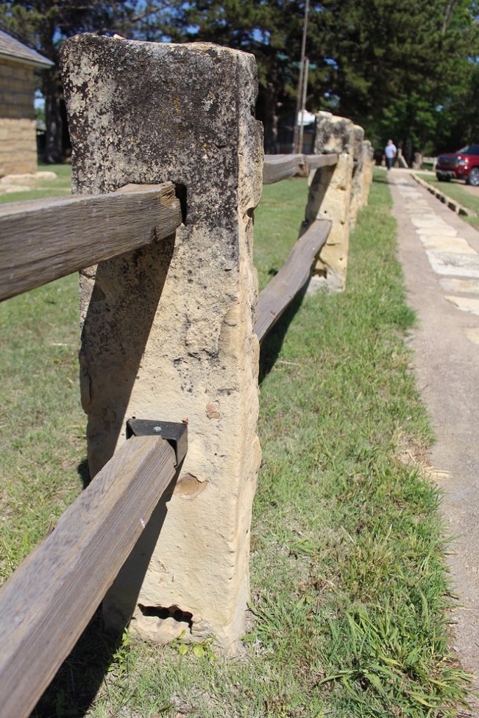
Because of their strength and stability, post rocks were needed only every 30 feet or so to support a barbed wire fence. Today, with the ready availability of steel and treated wood posts, post rocks aren’t nearly as high in demand. But in their heyday, from the mid 1880s to 1920s, post rocks were found in 40,000 miles of fencing in that swath of central Kansas – and, because of their durability (they’re rocks), many are still in use.
Barbed wire, at first glance, may not seem like a significant development. But without it, the expansion of Anglo-Europeans westward across the 98th Meridian would have been, at best, substantially delayed. Beyond the economics and geographic expansion, barbed wire had huge cultural impacts as well: because it disrupted the migration of bison herds, barbed wire also led to the displacement of dozens of Native American tribes that had considered the region their homeland for many generations. Barbed wire, with a solid assist from the railroads, is what made the Anglo-European development of the Great Plains possible.

The city of Colorado Springs is home to a number of U.S. military installations, including the U.S. Army’s Fort Carson; the U.S. Air Force’s Peterson Air Force Base, Schriever Air Force Base, and Air Force Academy; and the U.S. Space Force’s Cheyenne Mountain Station, Space Command, and Space Operations Command.
I spent some of my early years (1975-1979) growing up just south of Colorado Springs, and it was fun to be able to camp in the Goddard for a week in April a few miles from my childhood home. I’d forgotten how common it was to see people in military fatigues while walking around Colorado Springs: almost 10 percent of the population is active-duty military, and the defense industry is responsible for about 40% of the Pikes Peak region’s economy.
The U.S. military’s strong presence in Colorado Springs makes the city a fine host for the National Museum of World War II Aviation, which opened in 2012. The museum has a collection of 28 aircraft dating from the 1920s through just after World War II, and here’s what makes this collection unique: each of them still flies. Nancy and I have been to plenty of aircraft museums to see hundreds of aircraft, but this was the first one in which all of the aircraft could be taxied to a runway and take off. The airplanes are used in a number of airshows across the country, and therefore must be maintained to be reliable and safe in the air.
The non-profit museum is co-located at the Colorado Springs Airport with a private business called WestPac, which specializes in restoring and maintaining vintage aircraft. Our tour of the museum on April 29, 2022, also included a good look at what WestPac does to restore these beautiful birds and keep them in the air.

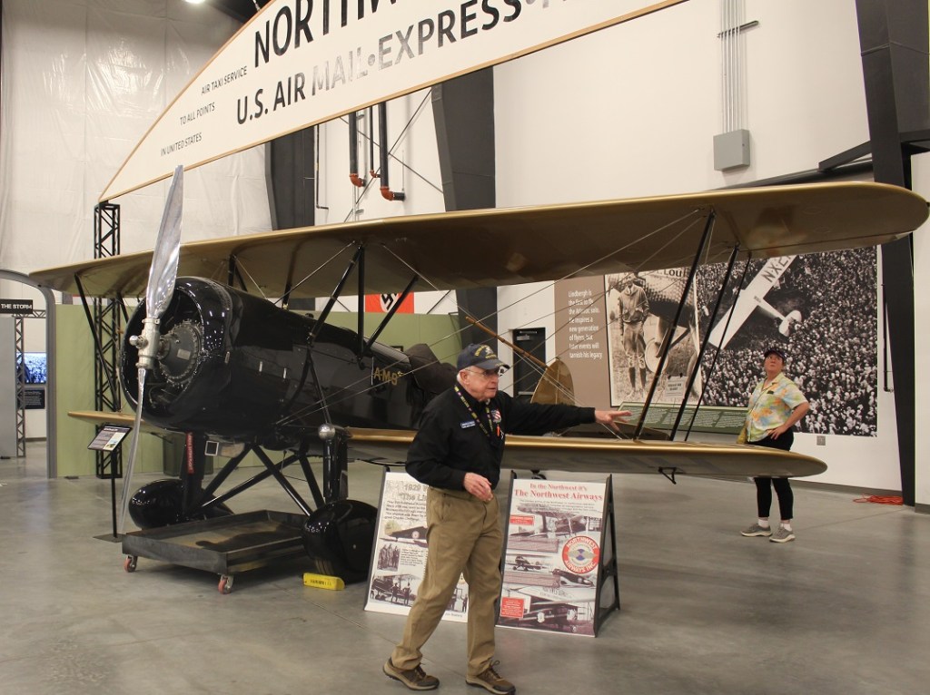
The Waco JYM doesn’t have anything to do directly with World War II but as is the case with all aircraft, its service record helped develop the technology used in later airplanes. The museum is right to be proud of having this airplane in its collection: it’s one of four Waco JYMs produced for Northwest Airways, and this 93-year-old aircraft is the only one still capable of flight (note the pan underneath the engine to catch oil – all of the aircraft in the museum’s collection have those). Mr. Lynch, a U.S. Navy veteran of the Vietnam War, provided a thoroughly educational and entertaining tour; he was able to speak not only about the mechanics required for powered flight from the viewpoint of an engineer, such as wing and propeller design, but also the global developments of World War II from a historical perspective. He’s one of the better docents Nancy and I have had the pleasure of meeting.

I don’t think Nancy nor I were prepared for how big these Navy planes were – I guess we’re just used to primarily seeing, in person at least, fighter aircraft that were used in the European theater of the war. An SPD-5 had a length of 33 feet, wingspan of 41.5 feet, and a height of 13.5 feet, all with an empty weight of 6,400 pounds. Interestingly, the Goddard, the fifth-wheel trailer in which we live, has a length of 35 feet and a height of just over 13 feet, but it has a dry weight of 14,000 pounds — it’s not expected to take to the air, though.
If you’ve seen either version of the movie “Midway” (the 1976 release with Charlton Heston or the 2019 edition starring a number of CGI pixels), the Dauntless is the airplane that gets the most screentime while showing the events of the battles of the Coral Sea and Midway. In the latter battle, these aircraft sank or disabled four Japanese aircraft carriers. Also serving in the Battle of Guadalcanal, the Dauntless was, despite its slow speed and relatively light armament, a very hardy and reliable dive bomber. These airplanes sank more enemy ships in the Pacific Ocean than any other World War II bomber. As aeronautic and armament technology increased rapidly during the war, the production of SBDs ceased in 1944.
It was a great experience to see an example of the aircraft that was able to so effectively counterattack the Japanese naval forces during the early weeks and months of the United States’ involvement in World War II. This particular aircraft has an interesting story: it crashed into Lake Michigan in May 1944, during aircraft carrier training exercises, and wasn’t extracted from the lake until the mid-1990s. It has since been restored to be a fully functional flyer, one of only six SBDs in the United States still capable of flight (one-tenth of one percent of the original total of 5,936 produced between 1940 and 1944).

TBF Avengers were not an immediate success story: of six unescorted aircraft that participated in the Battle of Midway in early June 1942, five were shot down and the sixth returned with one crewman dead and the other injured. As the war progressed, however, crews gained invaluable experience (each aircraft had a pilot, a gunner/radio operator, and a bombardier) and the Avenger played a pivotal role in naval operations; the airplanes destroyed two Japanese super-battleships and sank dozens of Japanese submarines in the Pacific and German U-boats in the Atlantic. The TBF/TBM had a maximum speed of 200 mph, with a range of 1,000 miles. It carried one 2,000-pound torpedo or 2,500 pounds of bombs, in addition to three .50 caliber machine guns and one .30 caliber machine gun.
George H.W. Bush, who would later serve as a U.S. President from 1989 to 1993, was shot down by Japanese forces during a September 1944 bombing mission while flying an Avenger. He parachuted from the plane and was picked up offshore by an American submarine.

This particular P-38, like many of the other aircraft in the museum’s collection, has an interesting history – including the deepest combat history of any other airplanes in the museum. Pilot Ken Sparks, on a mission on the last day of 1942, was credited with two aerial victories while flying this airplane. He downed one craft with gunfire, and then inadvertently clipped another with the Lightning’s right wing. The wingtip lost several feet of material, but the aircraft survived while the Japanese craft crashed. Sparks would have 11 more victories in several additional aircraft. This airplane was buried for decades near an airfield in Papua New Guinea, and was restored by WestPac in 2017.
This is another very large airplane, especially for a fighter, which made getting a good photo difficult – it has a wingspan of 52 feet. Empty, it weighs 12,800 pounds – twice the weight of the Douglas SBD Dauntless.


The National Museum of World War II Aviation is tremendously fascinating. Seeing a range of aircraft developed for both air combat as well as bombing was illuminating. It has fewer aircraft than most aviation museums we’ve seen, but the idea that all of the restored airplanes are still capable of flight really sets the museum’s collection apart. If you’re in the Colorado Springs area, the museum is well worth a visit – the aircraft there are really quite beautiful machines.

We made our first visit to Petrified Forest National Park on March 25, 2022, restricting our time to only the northern, smaller section of the park. That part doesn’t have much in the way of petrified wood, but it has plenty of awe-inspiring views. We returned the next day, with Gunther, to experience the southern side, and we did see some fossilized wood. And how!
Petrified Forest National Park, which measures about 350 square miles, receives about 600,000 visitors per year. That number, while impressive, makes it just the third-most-visited national park in Arizona, following Saguaro National Park in Tucson (1 million visitors per year; Nancy and I were two of those people a couple of weeks earlier) and the most-visited park in all the land, Grand Canyon National Park (4.5 million). Incidentally, Rocky Mountain National Park in north-central Colorado is just behind Grand Canyon, at 4.4 million visitors per year. If you’ve been to Rocky Mountain National Park in the last 20 years and felt a bit cramped, it’s probably due to 4.4 million other people visiting a park measuring 415 square miles.

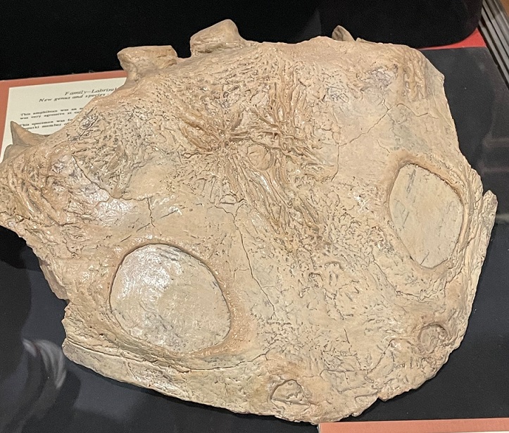
But we’re here to talk about rocks. A piece of petrified wood isn’t really wood any longer: it no longer contains any organic material and it is most definitely a rock. The process of petrification takes several important factors, including a tree, water, sediment, and time. Lots and lots of time.

Let’s start at the beginning. The scientists believe that the trees in Petrified Forest National Park were alive between 210 and 227 million years ago. At that time, the Late Triassic Period, the current area of the park was just north of the equator – in fact, it was close to where Costa Rica is today. The land was much different then: covered with forests of immense trees as well as large rivers and other wetlands. Huge amphibians and early dinosaurs roamed the forests and dwelled in the rivers. (Although there were many dinosaur species in the ensuing years, famous dinosaurs such as Tyrannosaurus rex and Triceratops wouldn’t appear until the Late Cretaceous Period, almost 160 million years later.)

Many of these coniferous trees (there are nine species identified in the park; all are now extinct) grew to be enormous: some may have grown to 200 feet in height. When the trees died they lost their branches and bark, then eventually toppled over after being undercut by a river. If the tree fell into the river, it may have eventually been covered in sediment being carried by the waterway. This relatively rapid burial is critical to later petrification: the water sealed the dead tree away from both oxygen and bacteria, which helped prevent decay. That delay gave time for silicic acid in the rivers to percolate throughout the tree. This process chemically altered the wood into a mineral called opal that still retained the tree’s fine features, like the grain of the wood, or indications of where branches once sprouted from the trunk.


Converting the wood into opal took only a few thousand years. Further layers of sedimentation over millions upon millions of years would cover the logs with tons upon tons of soil and rock. This process recrystallized the logs, converting the opal into quartz and a few other minerals. Over many other ensuing millions of years, erosion and geologic upheaval brought the logs back to the surface of the earth to once again see the light of day – this time as petrified wood.
Now that you know the factors involved in creating petrified wood, can you name the states in our country that contain it? The answer is below – keep on scrollin’!

The visitor center at the southern end of the park, which is part of the original monument created in 1906 (it was made a national park in 1962), contains some interesting fossils of both trees and animals. The fossilized remains of many amphibians and some dinosaurs dating to the time that the trees were alive have been discovered in the park (and the process for creating animal fossils is much the same as that used to create petrified wood). The museum also exhibits some handwritten letters: apparently, some visitors over the years were unable to withstand the temptation (and federal law) to leave the petrified wood where it lay within the park. Upon their return home with a fossilized wood souvenir, some of them inexplicably fell into bad fortune, such as personal or business relationship issues, and returned the rocks via mail, with an apologetic letter, to the national park.

After going to the visitor center and museum, and walking the Giant Logs Trail behind the building, we decided to go on a longer walk to see some more rocks. The Long Logs Trail, located a short distance from the visitor center, is so named because some of the petrified wood is more than 180 feet in length.


About the states that contain petrified wood: were you able to name them? If you named all 50, you’re correct. Although each U.S. state contain some amount of petrified wood, northern Arizona is able to display one of the largest concentrations in the nation because of the geologic upheaval processes that brought the logs to the surface of the earth.


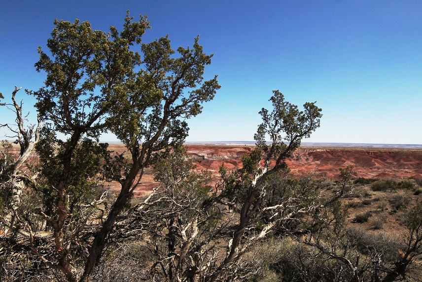
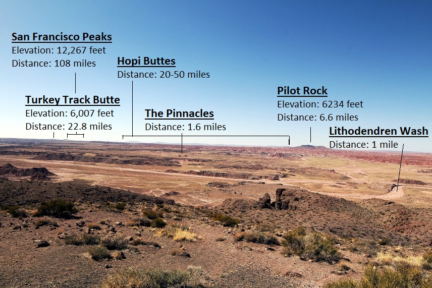
Progressing east and west, Interstate 40 divides Petrified Forest National Park into northern and southern sections. The interstate generally follows the path of historic U.S. Route 66, which connected the midwestern United States to the country’s west coast in the first half of the 20th century. Although Route 66 stretched more than 2,200 miles from Chicago to Los Angeles, Petrified Forest is the only national park with former segments of the historic highway within its boundaries. The area south of the interstate, much larger in size than the northern part, contains most of the petrified wood specimens in the park. The northern area, however, boasts incredible roadside vistas of the Painted Desert and a sizable national wilderness area. Nancy and I visited the northern part of the park in late March. Gunther stayed with Rusty in the Goddard, but Nancy and I would enjoy the dog’s company when we returned to the park the following day.
We briefly stopped in at the northern visitor center, which was undergoing significant renovation at the time, then proceeded to drive along a route that included a number of overlooks of Petrified Forest National Park.
I decided to use my 14mm wide-angle lens for taking pictures the day we visited the Painted Desert. I got it a couple of years ago to primarily take pictures of the night sky but thought its properties would help capture the feeling of the vast open landscapes of Petrified Forest National Park. There is a disadvantage to using this lens, though: it’s not automatic, so the aperture, ISO, and other settings all must be set manually. I’m no good at any of that. Many of the photos I took were over- or under-exposed, and I had to make manual adjustments using a couple of pieces of photo editing software.
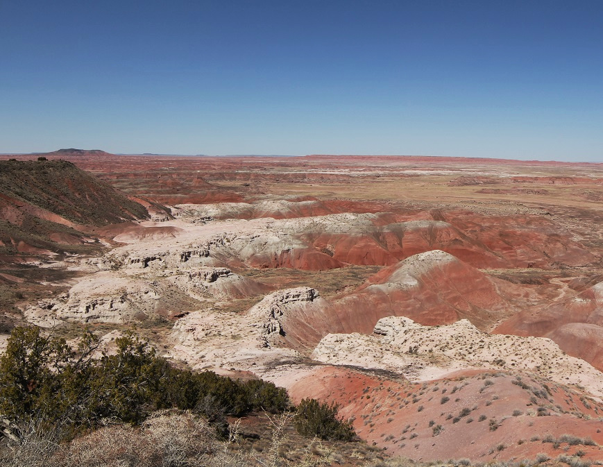
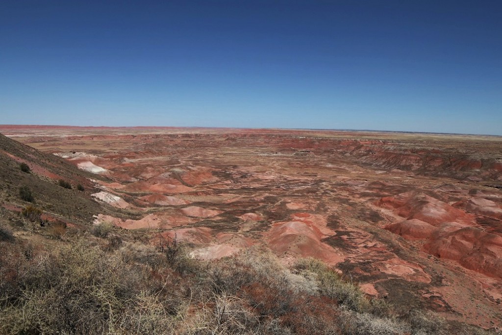
Petrified Forest National Park contains only a small part of the Painted Desert, which stretches across almost 8,000 square miles of northeastern Arizona. The colorful rocks, primarily mudstone and sandstone, of this region are called the Chinle Formation. Deposited from 227 to 205 million years ago during the Late Triassic Period while most of the land area on Earth was on the single supercontinent Pangaea, the rocks have been buried, lifted, and eroded during Pangaea’s breakup and shift into today’s major continents.
During the Late Triassic Period, the land comprising Arizona’s Petrified Forest National Park was located just north of the equator and supported a much different environment (different enough, for example, to support a forest of 180-foot-tall trees that would later become petrified). As Pangaea divided, the land mass migrated north and the land itself underwent massive changes.

The Chinle Formation is itself divided into five members: Mesa Redondo, Blue Mesa, Sonsela, Petrified Forest, and Owl Rock. Each member represents a transition of the land from wet to dry environments over millions of years: the Mesa Redondo, the oldest layer and therefore the one underlying the rest of the formation, consists of red sandstone originally laid down 226 million years ago, and the youngest, Owl Rock, includes pink and orange mudstone at the top of the formation that was deposited 207 million years ago.

Older rock formations in the Painted Desert are at the bottom of the geologic column, and the layers of rock grow younger in age as the elevation increases. The colors of these rocks come from the iron they contain. Drier climates allow the minerals to become exposed to oxygen, causing the iron to rust and develop distinctive red, brown, and orange colors. When the climate is wet, moisture essentially covers the sediments and prevents their oxidation. Those layers are colored blue, gray, and purple.
Nancy and I took a short hike along the rim of the basin, and one of the highlights of that walk was a stop at the Painted Desert Inn, which was originally built as a respite for travelers on Route 66. The highway passed just a short distance south of the building, and a spur road brought visitors to the inn for refreshments.

The interior of the Painted Desert Inn now serves as a visitor center for the Painted Desert as well as a museum with artifacts from the inn’s heyday. It’s all very impressive and you’re going to have to take my word on that because none of the pictures I took inside turned out.
Despite my photographic foibles, we really enjoyed this first visit to Petrified Forest National Park. I grew up on the eastern plains of Colorado, and I know long, uninterrupted distances. They are nothing compared to what can be seen in northeastern Arizona.
We’d see more of the park, and a little bit of actual fossilized wood, the next day. (Actually, we’d see a lot of fossilized wood. So. Much. Fossilized. Wood.)

Holbrook, Arizona, located in the northeastern corner of the state, is the seat of Navajo County, which was split off from neighboring Apache County in 1895. Both counties are still huge: Navajo measures 9,960 square miles, and Apache still has more than 11,000 square miles even after the division. Navajo County is bigger than the state of Vermont and just slightly smaller than Massachusetts. (For reference, my home county in eastern Colorado, Kit Carson, is considered very large at 2,162 square miles; in fact, Navajo County is about a tenth the size of the entire state of Colorado.)
Nearly two-thirds of Navajo County is designated Native American reservation land, including parts of the Hopi Indian reservation, the Navajo Nation, and Fort Apache Indian Reservation.
We camped in Holbrook for a week because of the town’s close proximity to Petrified Forest National Park – the park is only 25 miles northeast of the city – but we found plenty to like about the town itself.
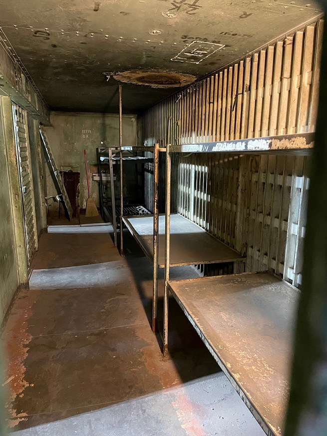
The Navajo County Courthouse, completed nearly 125 years ago, is now home to the Navajo County Historical Society’s museum. Built in 1898 at a cost of $15,000, including a $3,000 jail, the courthouse was in use until 1976 when the Navajo County Correctional Complex was constructed on the south side of Holbrook.

The museum was open on a Sunday afternoon in March after the Goddard’s arrival in Holbrook, so we were able to spend a few pleasant hours touring the exhibits.
The first exhibit in the museum is the county jail, which is to the right after one enters the courthouse. The jail was built in Kansas City, Missouri, by the Pauly Jail Company, which began operations in 1856 and is still in business today – be sure to consider it for any incarceration needs you may have. The jail was then shipped by rail to Holbrook and placed in the still-under-construction courthouse.
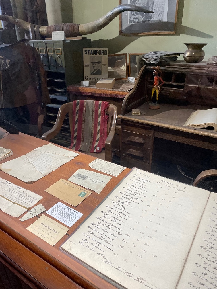


Firmly deciding to continue living our lives on the straight and narrow path, Nancy and I proceeded to other parts of the museum. Volunteers for the Navajo County Historical Society spend more than 2,000 hours each year curating and conserving artifacts from Holbrook’s past. The items represent the lives of Native Americans, Euro-American settlers, ranchers and cowboys, bankers, homemakers, railroad employees, teachers, merchants, and travelers through the area over the past centuries. Like many community historical museums we’ve visited, the exhibits in the building show a tremendous range of cultural, social, and economic pursuits. I wish other museums, however, were as well curated as Holbrook’s: the society has really done a fine job of keeping the exhibits relevant and reasonably sized.
Holbrook makes much of its location on the former Route 66, one of the original highways of the U.S. Highway System. Established in 1926, Route 66 connected Chicago, Illinois, with Santa Monica, California, and passed through the states of Missouri, Kansas, Oklahoma, Texas, New Mexico, and Arizona in its 2,448 miles.
Route 66 was an extraordinarily important highway in the first half of the 20th century, serving as the primary means by which Americans migrated to the West – especially during the Great Depression (John Steinbeck’s novel “Grapes of Wrath” alludes heavily to the highway). The route proved to be an essential economic driver for dozens of cities and towns along the way, as businesses provided food, fuel, shelter, and services to those who traveled the highway. Route 66 was officially removed from the U.S. Highway System in 1985, having been mostly replaced by a variety of segments of the U.S. Interstate Highway System.

In addition to the town’s Route 66 connection, the Holbrook museum also features extensive exhibits on the Aztec Land & Cattle Company. The company was founded in Boston, Massachusetts, in 1884 to take advantage of significant drops in cattle prices in Texas. Many large ranches in that state had continued to add to their herds, intending to reap profits when the beef markets improved. However, lingering drought caused prices to drop even further.
Aztec bought the Continental Cattle Company and its Hashknife brand (so called because the cattle brand resembled a bladed kitchen utensil), then shipped a total of 60,000 cattle and 2,200 horses from Texas to northeastern Arizona. The cattle were grazed on land purchased for 50 cents an acre from the Atlantic & Pacific Railroad. The grazing lands stretched about 300 miles from just south of Flagstaff to the New Mexico border (Arizona and New Mexico were both U.S. territories until 1912). With the ranch headquarters in Holbrook, the company’s employee base was a significant economic force for the town. However, Holbrook’s population of 300 residents found that not all of the Hashknife Outfit’s cowboys were of the law-abiding type. Cases of armed robbery and cattle rustling escalated, and there were 26 shooting deaths in 1886 (again, in a town of 300 people).
As was typical in the days of the Old West, range wars involving different ranches and their possessions were common. Many of the cowboys involved, either current or former Aztec employees, were incarcerated or outright killed.
The original end of Aztec as a beef-raising company came in 1902, with a drought, flooding, and overgrazing that destroyed the land on which the cattle were grazed. Aztec sold off its land and its remaining cattle, and the Hashknife brand was sold to a family in Flagstaff (and Aztec continues today as the third-largest private landowner in Arizona).
However, many of the cowboys of the Hashknife Outfit would go on to become respectable citizens of Holbrook and the surrounding area as independent ranchers, law enforcement officers, businessmen, and community leaders.
Although it was definitely the largest, the Aztec Cattle & Land Company wasn’t the only cattle concern around Holbrook and the museum has many artifacts about the ranching way of life.
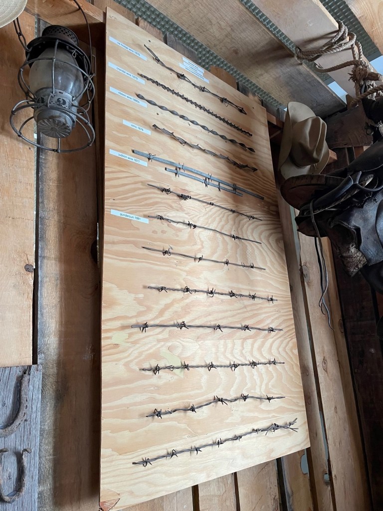
Charles Goodnight, a Texas rancher and cattle trail developer, is credited with introducing the chuckwagon, a mobile kitchen used to keep cowboys’ bellies full, in 1866. Goodnight’s model was a modified wagon from the U.S. Civil War, to which he added a box with drawers and shelves for food and supply storage. Goodnight’s cattle drives took cattle from Texas to New Mexico on the Goodnight-Loving Trail (which also followed part of the Butterfield Overland Mail route). He’d later go on to drive cattle from New Mexico up into Colorado and Wyoming. Cooks for the cattle drives would also serve as barbers, dentists, and bankers for the outfits, and were so important that they were usually second in command to the trailbosses.
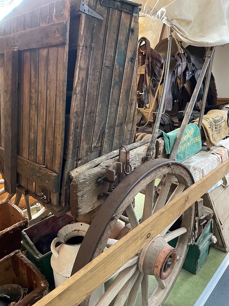
One of the things I really appreciate about community historical museums is the breadth of items they display. The artifacts can range in dates from the times of ancient Native American cultures up to the Great Depression of the 1930s and even more recent. As I wrote, the Navajo County Historical Society has excelled at displaying just a few items from each era in order to abstain from overwhelming visitors. Let’s go back even further in time for a moment: