We were fortunate to be near south-central Utah’s Bryce Canyon National Park on June 8, 2023 – the date happened to be the one hundredth anniversary of the park’s founding as a national monument. We had to leave Gunther at home (no dogs are allowed on the park’s trails, which is perfectly understandable) so we weren’t able to stick around for centennial celebratory cake at the park’s visitor center; however, if the cake was half as good as the park’s views, it was some mighty fine cake.
Because of its remote location, Bryce Canyon National Park receives significantly fewer annual visitors than nearby Zion National Park or Grand Canyon National Park. Kanab, Utah (pop. 4,800 and a stone’s throw from the Utah/Arizona border) is the closest town of any size, and it’s an hour-and-a-half drive away.
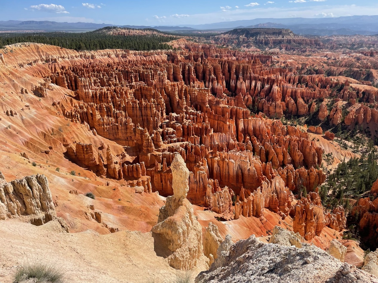
Ummm … yeah. The world is full of natural wonders, and the United States is home to quite a few of those places, and the Rocky Mountain West boasts its fair share of incredible views, but Utah is just stacked with scenic sites – it includes five national parks within its borders. The uncountable vertical rock formations in the foreground, boasting hues of red, yellow, and white, are called hoodoos. They’re formed, as are most really cool rock formations, by erosional processes. Bryce Canyon National Park contains the world’s greatest concentration of hoodoos.
Bryce Canyon National Park is the easternmost and highest “step” in the Grand Staircase, an immense geologic structure stretching across 100 miles of southern Utah and Arizona. The Grand Staircase includes two dozen distinct layers of rocks representing 525 million years of sedimentation from ancient inland seas, lakes, swamps, and forests. Arizona’s Grand Canyon contains the oldest rock layers and forms the western and lowest edge of the Grand Staircase.
Bryce Canyon National Park: By The Numbers
Date established as a national park
February 5, 1928 (declared a national monument on June 8, 1923)
Total area
35,835 acres (56 square miles, about one-seventh the size of Rocky Mountain National Park in Colorado)
Yearly visitors
2.4 million (RMNP receives 4.3 million)
Highest point
Rainbow Point, at 9,105 feet
Lowest point
Yellow Creek, at 6,620 feet
Despite its name, there aren’t any significant geologic canyons in the national park – the erosion of the limestone cliffs into the hoodoos and other formations we see today is mostly the work of frozen water rather than a flowing river. Between 55 and 35 million years ago, what is now Utah was a basin filled with mountains. Rivers in those mountains deposited tremendous amounts of dissolved limestone into huge lakes. About 20 million years ago, the Colorado Plateau was uplifted and the lakes were drained to expose the limestone layers that form the beautiful rock formations of Bryce Canyon. Erosional forces, including freezing and thawing water as well as rain and snow, over the ensuing years carved cliffs out of the limestone, which were eventually further sculpted into narrow walls called fins and then eventually rows of the rounded columnar formations called hoodoos; if you look at pictures of hoodoos and imagine the spaces filled with rock, that’s what the fins used to look like.
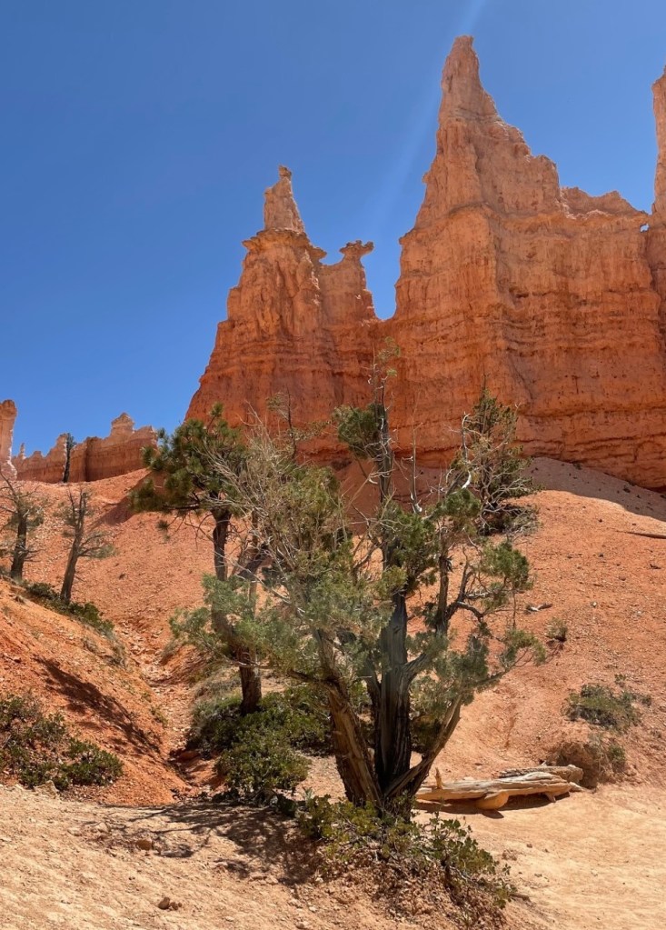
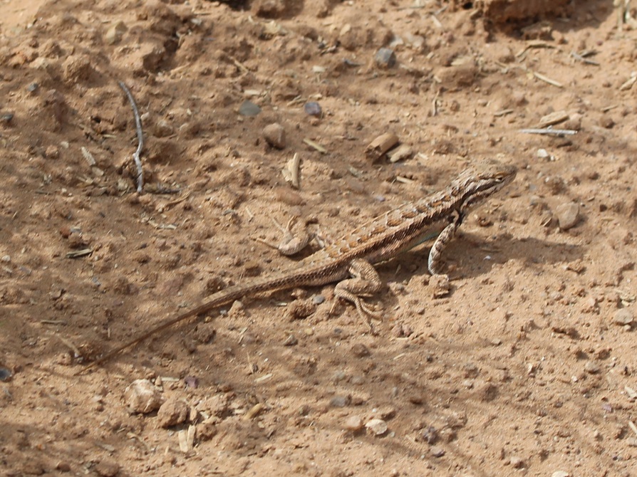
Although the skies weren’t crystal-clear the day we visited the national park, we still had some incredible views from the overlooks. This image was taken looking east. In addition to the marvelous rock walls and hoodoos in the foreground, formations 20 miles away and even further could be easily seen. Canaan Peak has an elevation of 9,293 feet. A winding hiking trail can be seen in the mid-foreground on the right side of this image.The national park’s namesake, Ebenezer Bryce, was born in Scotland in 1830. He was a ship’s carpenter and, after converting to the Church of Jesus Christ of Latter-day Saints, emigrated to the United States in 1848. He married Mary Park in Salt Lake City in 1854, and the family (which then included five children; he and Mary would have a total of 12) moved to southern Utah’s Pine Valley in 1862. Shortly thereafter, he moved to a homestead in the nearby Paria Valley which is south of the present-day national park. He built a road for timber access that ended in a natural bowl-shaped area, or amphitheater; that area became known as “Bryce’s Canyon.” In 1880, he and his family moved to Arizona, near Pima, where he passed away in 1913. [Photo courtesy Washington County (Utah) Historical Society.]The name of this pretty flower, the sego lily (Calochortus nuttallii), derives from a word (“sikoo”) in the language of the Shoshone, who taught early (and hungry) Mormons that nearly all of the plant, including the bulb, is edible. The plant’s value as an important pioneer foodstuff later led to the adoption of the sego lily as Utah’s state flower in 1911. The large-grained grass at left is Indian ricegrass (Eriocoma hymenoides), also an important part of native Americans’ diets. It is the state grass of both Utah and Nevada.The second column from left shows a “window,” in which the erosional power of frozen water, in the form of snow, frost, and ice, wedges small crevices into larger openings. It’s very likely that frost and rain will erode away the rock forming the top of the window, resulting in the columnar shapes called hoodoos. Because of its elevation, Bryce Canyon National Park experiences freezing temperatures half of the nights of the year.After enjoying the views from several overlooks while on a scenic drive around the park, we embarked on a fairly challenging hike in the early afternoon that combined the Navajo Loop with the Queen’s Garden Loop. It gave us the opportunity to walk on wooded footpaths, see plenty of wildflowers and birds, and marvel up-close at the rock formations. These hikers are walking past some hoodoos that have several windows.Here’s a view of the Queen’s Garden Loop namesake: if you squint at the top of the hoodoo just left of center, you can kind of maybe sort of make out something that resembles Victoria, Queen of the United Kingdom of Great Britain and Ireland (1819-1901). Did You Know/Care: there are almost 160 statues of Queen Victoria around the world. Also, I think it’s fun to imagine Queen Victoria saying the word “hoodoo.”THIS IS A TALES OF THE GODDARD LIZARD ALERT. Western fence lizards (Sceloporus occidentalis) have a wide distribution throughout the American West, and can live at elevations ranging from sea level all the way up to almost 11,000 feet. You can just begin to make out the most distinguishing characteristic of this species, its bright blue belly (look behind the right front leg).Nancy and I are both very experienced hikers and both of us recognize the need for switchbacks, or gradual increases in elevation by constructing a trail across the slope of an incline. These switchbacks at the end of the hike that day were the most in a relatively short distance that we’ve ever seen. It seemed like we walked 30 miles just to gain 300 feet of altitude. Still, it was an intensely rewarding hike and it was a great end to a great day at Bryce Canyon National Park.Looking northeast, this overlook at the end of the Queen’s Garden Loop awaits after that significant set of serious switchbacks. I mean, I’m writing this post one year after our visit to the park and I’m still just shaking my head at the views we experienced.THIS IS A BONUS TALES OF THE GODDARD LIZARD ALERT. This horned lizard was not at Bryce Canyon National Park, but in our campsite near Hatch, Utah, where we stayed for the week during our visit to the park. Horned lizards (I believe this is a greater short-horned lizard) are extremely well-camouflaged little creatures. Our campground was only 32 miles from Bryce Canyon National Park, but the winding drive took 45 minutes. We may have missed out on centennial-celebrating cake so we could make sure Gunther got outside for his afternoon walk, but, between the overlooks and hike we enjoyed, it was well worth it. Because of its remote location, Bryce Canyon is definitely a park that you have to want to get to, and that’s okay by us (but you should totally want to get to it).


Leave a comment