Bill’s Backyard Classics

Amarillo, Texas – October 16, 2026

I’m finishing up this blog posting on Oct. 23, 2026, the five-year anniversary of Nancy and I pulling away from our Denver home, then under a sales contract, in The Goddard and starting our lives as full-time RVers. We’ve been to 19 states and in dozens of small towns and big cities since then, and we’ve had the opportunity to see wonders both natural [Grand Canyon National Park in Arizona, Yellowstone National Park in (mostly) Wyoming, remarkable sunsets in Albuquerque and Texas] and manmade (Hoover Dam in Nevada and Arizona; the Ford Motor Company’s historic River Rouge plant in Dearborn, Michigan, that can produce a thousand F-150 pickups every day, and museums that exhibit everything from airplanes to the Dust Bowl to barbed wire).

One of our favorite types of museums to visit is a collection devoted to automobiles. Some focus on a specific model, like the Jeep museum in southern Utah that I still need to write about, and others that display vehicles from a wide variety of manufacturers.

Bill’s Backyard Classics, in Amarillo, Texas, is one of the latter, and it’s a good one. Bill Pratt was a successful entrepreneur – he held nearly 90 patents, mostly in the beef industry – and he and his wife, Linda, moved to Amarillo from Oklahoma after selling his business. His professional success left him with the resources to pursue one of his hobbies: acquiring classic cars. He pursued that hobby pretty hard; the collection over the years grew to more than 100 vehicles. In 2015 he and Linda built Bill’s Backyard Classics to house the collection so that the vehicles could be appreciated by the general public.

Bill bought all of the cars already refurbished and in their then-current states – some have new engines, for example, or CD players in the dashboard that didn’t exist until 20 years after the vehicle was first produced. Some don’t need any work at all: the collection includes a 1956 Cadillac Series 62 sedan that has 14,733 miles on the odometer. Many people drive their vehicles more than that many miles in a single year. Also, except for one that has a cracked engine block, all of them still run.

Although the collection includes dozens upon dozens of vehicles, it’s pretty apparent that Bill was a General Motors guy: the museum includes lots of Cadillacs and Chevrolets and Buicks (and there’s absolutely nothing wrong with that), but there are plenty of Fords, and Jeep and Hudson and Dodge and other makers are represented as well. Signage on each vehicle’s windshield gives information about the engine, transmission, standard and optional equipment, and the sequential number of the vehicle in Bill’s collection.

Bill (Nov. 5, 1942 — Oct. 21, 2020) and Linda (Sept. 19, 1943 — Jan. 1, 2023) may be gone, but their wonderful automotive legacy lives on at Bill’s Backyard Classics.

Thanks to the museum’s docent Kay, who took time out of her day to show Nancy and me around and offered so much background information on the vehicles we saw. She’s great.

1928 Ford Model A
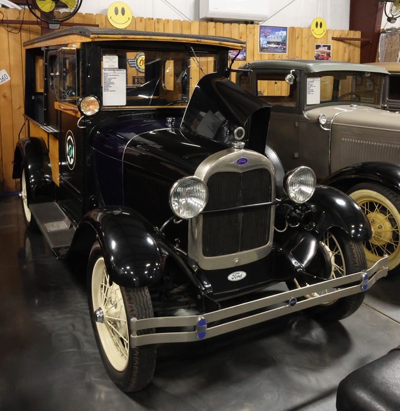
This is the oldest vehicle in the museum’s collection – it’s just shy of 100 years of age. Including standard and deluxe couple styles, Model A Fords came about 20 different models in the production years of 1927-1932. When introduced, Model As came in four different color options – as opposed to the original Ford Model T, which was available in the very popular color of black.

This Model A, the 72nd vehicle in Bill’s collection, is a truck that has been converted for use by a law-enforcement agency – the logo of the Mohave County (Arizona) Sheriff’s Department is on the doors, and the back compartment has a wooden bench with a ball and chain. Colloquially it’s a “paddy wagon,” although that term didn’t come into usage until the 1930s. Model As came with a 201 cubic-inch-displacement (CID) (3.3 L) engine that provided 40 horsepower (HP). The cars had a top speed of about 65 MPH (105 KPH).

Ford produced the Model A and all of its different styles – coupes, convertibles, phaetons, town cars, Victorias, station wagons, and more – from October 1927 through March 1932, building 4.8 million cars during that time.

Ford Motor Company’s cars have been popular with police and sheriff’s departments since the company’s beginnings, and Ford often sells cars directly to law-enforcement agencies. My dad was the sheriff of a rural county in eastern Colorado, and a specially equipped Explorer or a Ford Crown Victoria with the Kit Carson County Sheriff’s Department logo on their doors spent their nights in our garage (my 1971 Ford Mustang had to spend its nights outside). I don’t know what the top speed of those law-enforcement vehicles was, but I imagine they could go faster than 65 MPH. If I remember correctly, my Mustang was capable of occasionally exceeding 65 MPH.

1929 LaSalle Series 328
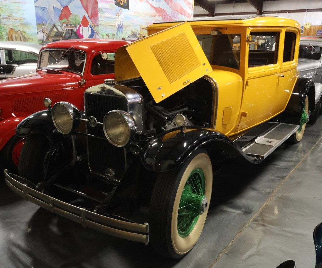
Following the Ford Model A, this is the second-oldest vehicle in Bill’s collection and the 115th that he acquired. LaSalle was a brand built and marketed by General Motors’ Cadillac division, intended as the second-most-prestigious brand in GM’s Cadillac portfolio (which also included Marquette, Viking, and Pontiac). LaSalles, produced from 1927 through 1940, were priced lower and were somewhat smaller than Cadillac models.

In the 1920s, Alfred P. Sloan (May 23, 1875 – February 17, 1966), president, chairman, and chief executive officer of General Motors, saw that a gap existed between luxury vehicles, like GM’s own Cadillac marque, and the lower-priced vehicles represented by the company’s Chevrolet line. The introductory LaSalle model, one of the vehicles intended to fill that gap, was designed by Harley Earl (November 22, 1893 – April 10, 1969), who would go on to become a GM vice president. Among his other work at GM, Earl started a project there that would result in the introduction of the Chevrolet Corvette; the idea of a “concept car” idea, showcasing new automotive technologies or styling that may or may not show up later in production vehicles, was his as well. Also, “Harley” is an excellent first name.

The LaSalle name is featured in one of the lines in “Those Were The Days,” the opening theme song of the television show “All In The Family,” in which Archie and Edith Bunker sang, “Gee, our old LaSalle ran great.” And gee, they did indeed run great: in 1927 at GM’s Milford Proving Ground, which is still extant in Milford, Michigan, a LaSalle with a 303 CID (5.0 L) engine ran for 952 miles (1,532 K) and averaged 95.2 MPH (153.2 KPH). For comparison, the winner of the Indianapolis 500 that year averaged 97.5 MPH (1,569 KPH) in the race. The Series 328, pictured here in resplendent yellow, represented a major engine upgrade to the LaSalle with a 328 CID (5.4 L) V8 powertrain, offering 85 HP.

The LaSalle was a very popular car – GM sold 22,691 of the 1929 models– and annual sales in later years sometimes exceeded the number of Cadillacs sold. However, The Packard Motor Company’s Twelfth Series One-Twenty, introduced in 1935, outsold LaSalles by an average of 72 percent in the years 1935-1940, and GM decided to discontinue the LaSalle brand and bring its legacy into the Cadillac marque.

You might recognize, as I did, Sloan’s name from the philanthropic organization he started in 1934: the Alfred P. Sloan Foundation, currently at an endowment of more than $2 billion. Among other science- and technology-related efforts, the foundation is a longtime supporter of programming like “American Experience” on the Public Broadcasting Service (PBS).

1934 Buick Sedan
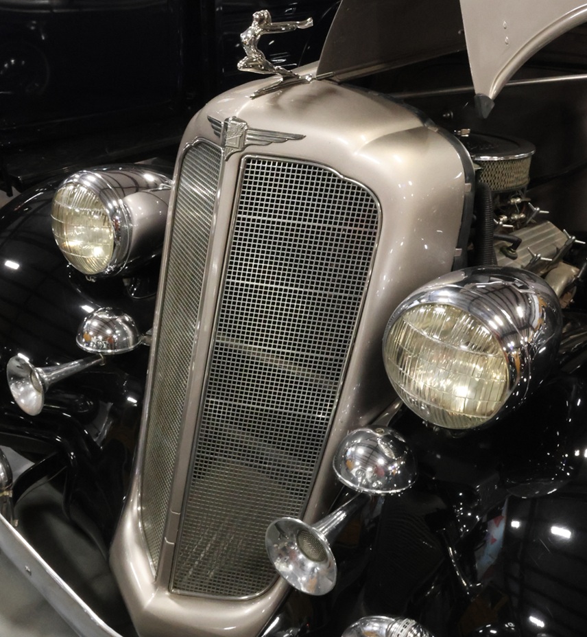
I mean, c’mon. This is the front end of Bill’s 32nd acquisition, a 1934 Buick Sedan, and it’s simply gorgeous in design and detail. So much chrome! The 1934 Buick Sedan came in four series: the entry-level Series 40, and the upmarket series 50, 60, and 90. It’s credited with a dramatic rebound in Buick’s annual sales, especially through the years of the Great Depression (1929-1939). I won’t include a photo of the car’s rear end, but there’s a large-ish storage compartment on the back in which one could place luggage, or perhaps materials for picnicking, to bring along in one’s automobile adventures. In the parlance of the time, Buick called the compartment a “trunk.”

1945 Jeep (Military)

Bill’s 52nd vehicle acquisition was this 1945 Willys-Overland Jeep. Under license from Willys, the Ford Motor Company also produced Jeeps; between the two companies, about 640,000 of these vehicles rolled off American assembly lines and into service in World War II. The engine in this particular Jeep is a 4-cylinder, 133.39 CID Willy’s Model MB that produces 50 HP.

In the very early 1940s, realizing that the United States would likely be entering the European theater of World War II, the U.S. government requested prototypes of a four-wheel-drive reconnaissance vehicle from 135 companies; only two answered the call: The American Bantam Car Company and Willys-Overland. Bantam produced a prototype that met most of the U.S. Army’s specifications, but lacked production capacity to deliver the quantity needed by the U.S. government. The Army gave the Bantam design to Willys and Ford, both of which made design enhancements before each developed 1,500 prototypes (Bantam also made the same number) for testing. After Willys included the L134 “Go Devil,” a powerful-for-its-size 134.2 CID (2.199 L) engine that produced 60 HP (45 KW), the Army awarded the production contract to Willys.

Because a large number of vehicles were needed quickly, the United States Department of War requested that Willys grant the U.S. government a license to select another supplier to produce the Willy’s Jeep using the company’s specifications – that supplier was Ford, which had plenty of manufacturing capacity and expertise. Like all automotive manufacturers during the years of the country’s involvement in the war, Ford had ceased building cars and began building war materiel. The company famously converted its Willow Run production facility into a B-24 Liberator factory, producing one bomber every 63 minutes. The very familiar vertical-barred grill of a Jeep, by the way, was a design contribution from Ford – that design even became part of Jeep’s logo for many years. American Bantam, the original designer, also contributed about 2,700 Jeeps to the war effort, but later focused on the production of heavy-duty trailers for the U.S. Army.

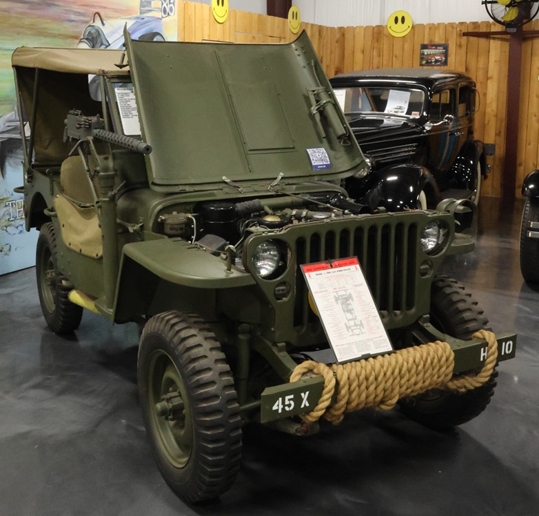
The particular vehicle on display in the museum looks like it has been in a secure storage environment since 1945 – absolutely immaculate, with all of the period hardware as well. I’ve not seen a Jeep with a mounted machine gun, for instance, and there are other weapons, ropes, and tools stowed and stored all over the vehicle.

Willys-Overland was purchased by Kaiser Motors in 1953, and Kaiser-Jeep was sold to American Motors Corporation (AMC) in 1970.

The Jeep, born out of military needs, was highly influential as a forerunner of today’s incredibly popular sport utility vehicle market. Willys launched the Jeep CJ (for Civilian Jeep) following World War II, and the Jeep Wrangler took up the reins in 1986 and has been in production since then. Jeeps also led to modern military four-wheel-drive vehicles, such as the Humvee, and to civilian SUVs such as Land Rovers and Ford Expeditions and Chevrolet Suburbans and dozens of other domestic and foreign-made models including smaller SUVs such as the Ford Escape and Subaru Outback. Jeep, now owned by Chrysler (which is itself owned by a multinational company called Stellantis) which bought it from AMC in 1987, plans to sell eight different models, ranging from the Wrangler to the Grand Wagoneer, in North America by 2030.

1956 Cadillac Fleetwood Series 75 Limousine

When Kay, our guide at Bill’s Backyard Classics, mentioned that this Cadillac had once belonged to Roy Hofheinz, I knew that name sounded familiar but I couldn’t place it. She went on to say that Hofheinz was instrumental in Houston, Texas, acquiring a Major League Baseball (MLB) franchise, and then I remembered: he was a former municipal judge and Houston mayor who came up with the idea of building a domed and air-conditioned sports stadium in the hot and humid Houston environment. (I, raised in Colorado’s arid environment, lived in Houston for about 18 months. I did not succeed in the hot and humid Houston environment.) The Astrodome was home to the Houston Astros MLB team from 1965-1999, as well as the Houston Oilers NFL team from 1968-1996 and the Houston Livestock Show and Rodeo from 1966 to 2002, among many other teams and events. The idea of a covered and air-conditioned venue for sports and events was novel in the 1960s, but it’s pretty standard nowadays all over the United States. Roy Hofheinz made the first one happen and this big car, number 29 in Bill’s collection of automobiles, belonged to him.

1957 Oldsmobile Ninety Eight

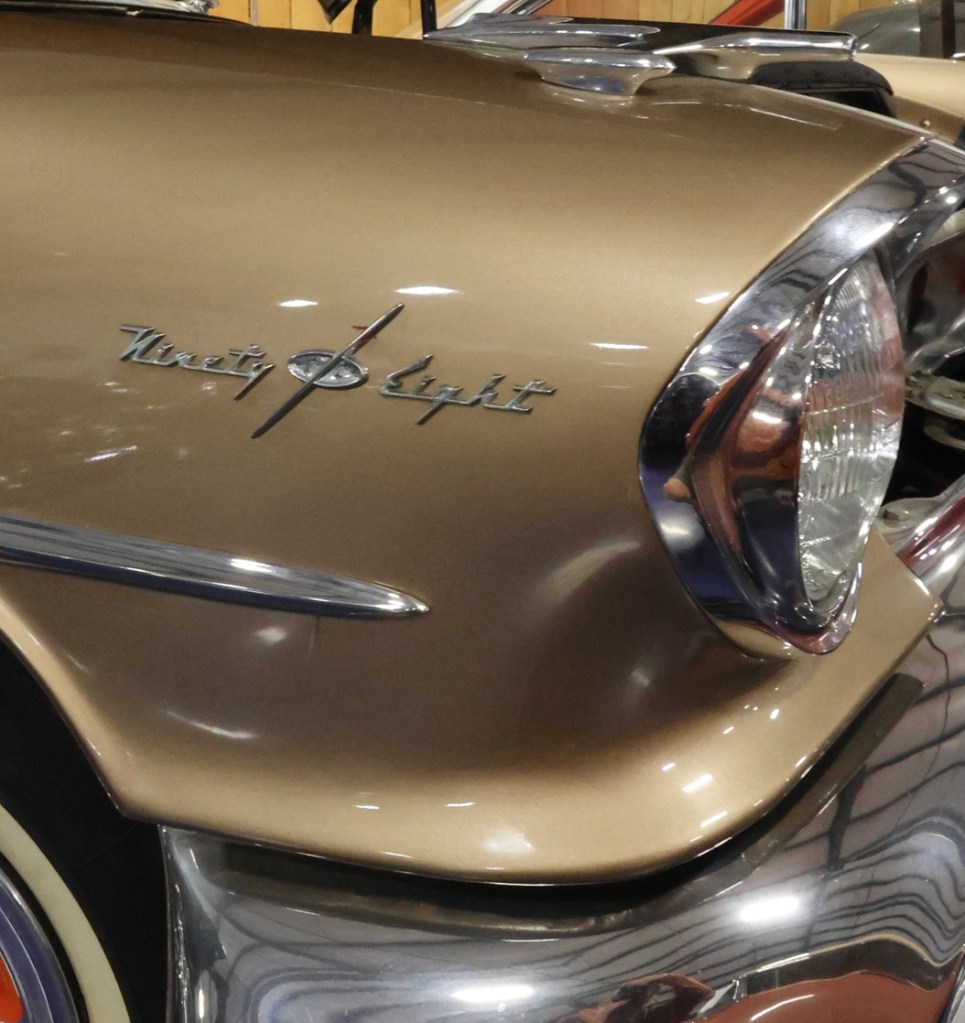
This sedan was the first in Oldsmobile’s fifth generation of Ninety Eight models, which it began building in 1941. It has a 371 CID engine, providing 312 HP, which was the standard motor in these cars. I’m not generally a fan of gold-colored vehicles, but the reddish-orange contrast on the wheels and body make this Ninety Eight look pretty sharp.

Here’s a closeup of the Oldsmobile’s badge, right headlight, and ornamentation above the headlight (there’s an identical one above the left headlight). Ninety Eights were Oldsmobile’s flagship models from their introduction in 1941 through their discontinuation in 1996. Oldsmobile itself was around from its founding in 1897 by Ransom E. Olds (June 3, 1864 – August 26, 1950), through its acquisition by General Motors in 1908 (it sat in the middle of GM’s passenger vehicle divisions, above Chevrolet and Pontiac but below Buick and Cadillac), until its dissolution, due to falling sales and profitability shortfalls, in 2004. Also, “Ransom” is an excellent first name.

1958 Cadillac Limousine

I don’t have much to write about this big and beautiful limousine other than to note that the fins on the back look large enough to lift this big and beautiful limousine into the air.

1958 Pontiac Bonneville

Again, I’ve not got much to write about this car other than to note that the letters between the headlights do, in fact, spell out “BONNEVILLE” – it’s difficult to make out unless you’re right in front of the car. Also, so much chrome.

1965 Ford Thunderbird

Ford Motor Company introduced the Thunderbird in 1955 as a two-seat convertible, but gradually expanded the model to include many other body styles over the years such as a four-seat coupe, four-seat convertible, a five-seat convertible, a six-seat coupe, and more. Ford positioned the T-Bird as “a personal car of distinction,” emphasizing style and comfort over sportiness.

One of the things I liked about my 1971 Mustang coupe was that the engine compartment, even with a 302 CID V8 engine, had plenty of room to work inside it. This T-Bird does not have that room, but it’s likely because the original 390 CID V8 engine with 300 HP was replaced with a Cobra Jet 289 CID V8 that offers 390 HP – a thirty-percent increase. Ford produced the Thunderbird until 1997, and then reintroduced the model as a two-door passenger convertible in 2002. After initial strong sales, those numbers dropped again and Ford stopped building Thunderbirds in 2005.

1968 Chevrolet Camaro SS

This is a car that my high-school chums and I would describe as “bad-ass.” To compete with the stylishly sporty and spectacularly successful Ford Mustang, introduced in the 1965 model year, Chevrolet developed the Camaro which began selling in the 1967 model year. Chevrolet had its work cut out for it: Ford sold one million Mustangs within that model’s first two years.

I’m a fan of the late-1960s musical group The Turtles (“Happy Together,” “You Baby,” “She’d Rather Be With Me”), which also recorded a fantastic commercial jingle for the Chevy Camaro (YouTube link). Do yourself a favor: listen to that song while imagining yourself behind the wheel of this car – it’ll drive you absolutely mod!

As shown directly behind the front driver-side wheel, this particular Camaro came with the Super Sport (SS) performance package, which included an upgrade to a 350 CID (cubic inch displacement) engine, an improved chassis to manage the additional engine power and offer improved handling, and aesthetic additions like non-functional air inlets on the hood, special paint striping, and the “SS” badging on the car. Of 235,147 Camaros built by Chevrolet in 1968, this is one of only 27,884 Super Sport models.

The 1968 Camaro SS had an additional option for a 396 CID engine that produced 350 horsepower at 5,200 RPM and 415 lb-ft of torque, which is a measurement of how quickly a vehicle’s engine allows it to start off the line from zero MPH, and how easily the vehicle can begin moving a load. The engine in the photo of this car is neither a 350 CID nor a 396 CID: at some time, a previous owner dropped a Chevrolet 454 CID engine into this car (the horsepower provided by the original 350 CID or 396 CID engine was apparently not sufficient). The 454 CID engine was introduced by Chevrolet in 1970 and was originally used in early 1970s Chevy muscle cars, including the Corvette, Chevelle, El Camino, and Caprice. The 454 CID engine’s maximum horsepower is 450 HP at 5,600 RPM, with maximum torque of 500 lb-ft at 3,400 RPM. The 454 CID engine remains popular in cars whose owners want them to go really, really fast.

As for the race for market share, the Ford Mustang is still in production while the Chevrolet Camaro stopped production between 2003 and 2009, and then resumed until ceasing again in 2024. The Camaro’s biggest model year was 1979, in which nearly 283,000 cars were produced (almost 370,000 Mustangs were built that year).
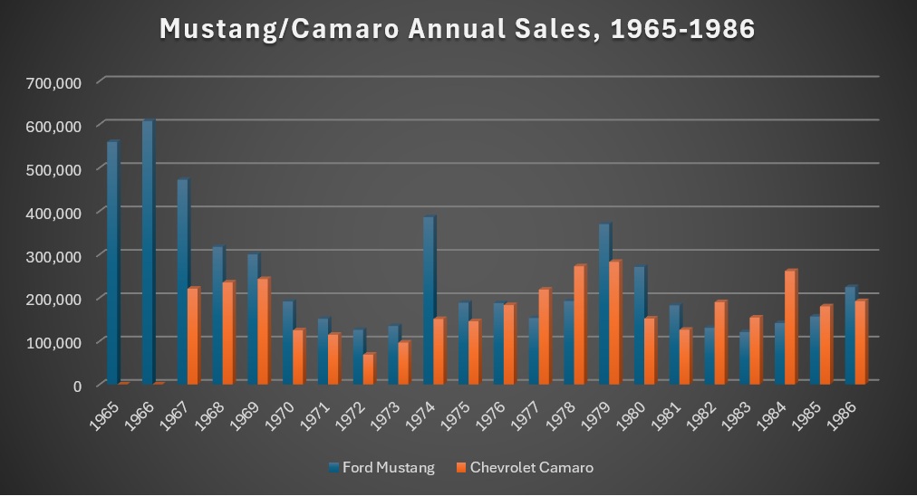
This chart shows the annual sales of Ford Mustangs (in blue) and Chevrolet Camaros (in orange) in the first 20 years of the Camaro. I’m including 1965 and 1966, in which the Camaro had not yet been introduced, to show what a tremendous lead Ford Motor Company had in the marketplace. Three items of note: the Camaro definitely had an impact on sales of the Mustang for its first three years. Second: it would be interesting to see how the rivalry would have developed without the oil crisis of the early 1970s, as well as rising muscle-car insurance rates and emission standards during that period. Third: I’m shocked that Ford was able to sell as many of the abominable Mustang II models as it did in 1974 (and I say that as a Ford guy and a Mustang guy). Note that it wasn’t until 1977 – 10 years after its introduction – that Camaro sales overtook those of the Mustang, and then Ford dug itself out of the Mustang II malaise with the introduction of the 1979 model. (Sales data from models’ respective Wikipedia pages.)

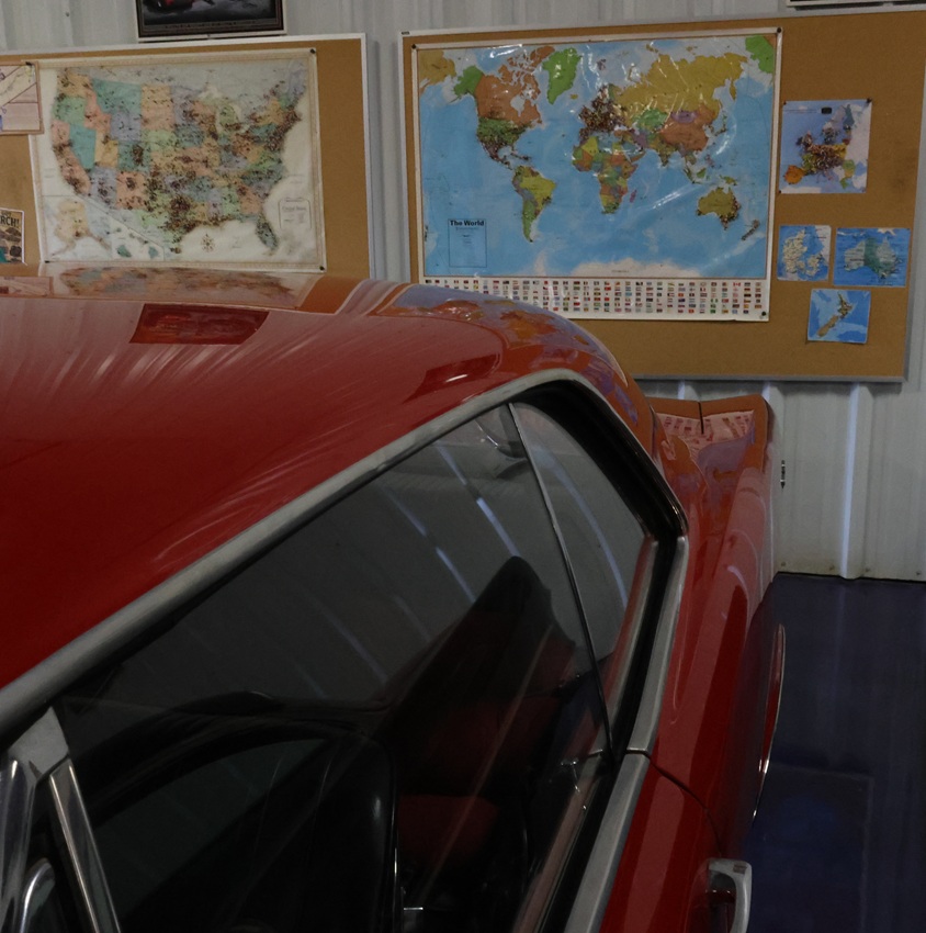
As seen beyond the rear driver quarter panel of a 1967 Pontiac GTO (which also qualifies as “bad-ass”), the museum has posted maps of the United States and the world on which visitors are asked to indicate their hometowns with pushpins. There have been so many visitors to Bill’s Backyard Classics in Amarillo, Texas, from New Zealand that the museum had to post a separate map of that country in the lower right corner of the bulletin board.

Given that the Model A engine produced 40 HP and the Camaro’s produces 450 HP, it’s pretty remarkable that only 40 years separate the first and last vehicles on this page. In those decades, the automobile industry saw incredible innovations and advancements in technology, safety, fuel efficiency, comfort, and style. Bill’s Backyard Classics provides a great opportunity to see those changes – vehicles didn’t used to come with seat belts, for instance, or turn signals, or storage trunks – gradually take place. It’s one of many car museums Nancy and I have visited, and it’s one of our favorites.
Denver Botanic Gardens

Denver, Colorado – August 5, 2026

While traveling around the country, Nancy and I try to visit botanic gardens whenever possible. In addition to the great opportunity to see all kinds of different plants, botanic gardens’ trees and flowering plants also attract a great variety of birds, butterflies, and other wildlife that we enjoy seeing and photographing.

Until October 2021 when we sold our Denver home and became full-time RVers, we made regular visits to Denver Botanic Gardens’ two sites. We’d most often go to the gardens in central Denver, but we also went to the gardens near Chatfield Reservoir in the southwestern metro area.

I was very fortunate to make a return visit to Denver Botanic Gardens’ central Denver site in early August, bringing along a camera and lens that I didn’t have five years earlier. I was planning to get a lot of photos of birds, but instead found a lot of other wildlife to enjoy.

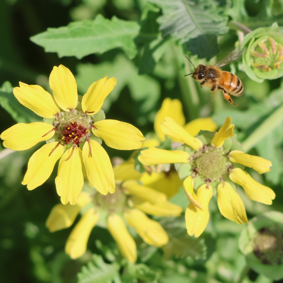
This is one of the first of about 150 photos I took during my 2 1/2-hour visit to the Gardens. It’s a western honey bee (Apis mellifera) on final approach to a bloom on a chocolate flower (Berlandiera lyrata). While researching this posting, I learned something pretty basic: the western honey bee, the most common of the honey bee species worldwide and found on every continent except Antarctica, is not native to the United States, or even the Americas. Colonists introduced honey bees to this country in the 17th century for the production of honey, which the bees make by collecting and processing flower nectar. Worker bees like the one pictured collect flower nectar and pollen (seen as the small orange clump on this bee’s left back leg) to bring back to their hive. The pollen and nectar both serve as food sources for the bees, and the nectar is also refined into honey. Rock art found in France and Spain indicates that humans have been collecting honey from bees since around 7,000 BCE. Pollination, the transfer of pollen from one plant to another either as bees and other animals visit different flowers or by the wind, allows the fertilization of plants. Whether it’s performed by animals or the wind, pollination is absolutely critical for plant reproduction: without pollinators, especially bees, we’d quickly run out of plants used for food and clothing. Chocolate flower, so named because of the fragrance it emits, is native to the southwestern United States and northern Mexico.

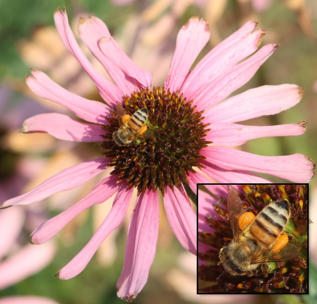
Here’s another western honey bee, this one on a cultivated Tennessee purple coneflower (Echinacea tennesseensis). I inset a closeup of the bee in the lower right corner to highlight the amount of pollen it’s collected. Comprising mostly simple sugars like fructose and glucose, as well as proteins, vitamins and minerals, and fatty acids, pollen is the main food source for the bees back at their hive. Honey is made by refining floral nectar, also collected by worker bees such as this one. Queen honey bees produce eggs for a colony numbering between 60,000 and 80,000 worker bees, all of which collect floral material for honey production; the workers also maintain the hive.

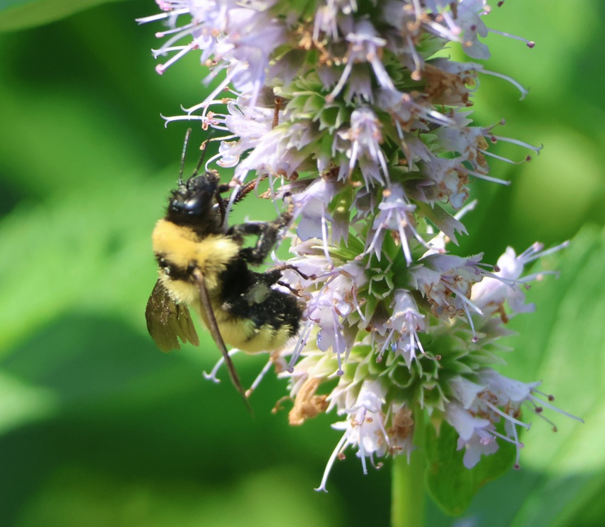
I was surprised to learn that 46 species of bumble bees have been identified in the United States. This is a Sonoran bumble bee (Bombus pensylvanicus sonorus), one of the 24 bumble bee species observed in Colorado. The scientists are still deciding whether the Sonoran bumble bee is a distinct species or a subspecies of the American bumble bee (Bombus pensylvanicus). This one was collecting material from a giant hyssop, a genus of agastache that includes more than 20 species and is very popular among pollinators.

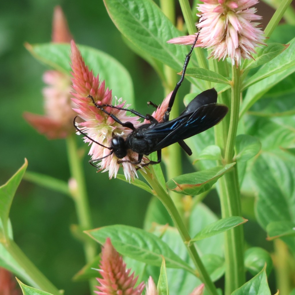
Bees and butterflies are the most prolific pollinators in the animal kingdom, but other insects like moths, wasps, flies, ants, and other six-legged creatures are important as well. This unimaginatively-but-accurately-named great black wasp (Sphex pensylvanicus) was easy to spot on the Gardens’ plumed cockscomb (Celosia argentea) blossoms. This wasp, the wings of which display a beautiful blue iridescence in the right light, grows to a length of 0.8-1.4 inches (20-35 mm); the top edge of your cell phone measures about 3 inches, so these are indeed big bugs . In addition to plumed cockscomb, which originated in tropical Africa, great black wasps are important pollinators of milkweed plants.

A group of three people was standing on the walk in front of me, and one of them was using their phone to film something. I started to pass the group, and then noticed that they were observing this American goldfinch (Spinus tristis). These beautiful birds are widespread throughout the United States (they’re the state bird of New Jersey, Iowa, and Washington), and can be seen seasonally in southern Canada and the eastern coast of Mexico. In one respect, American goldfinches are rare in the bird world: they’re strictly vegetarians, and eat insects only incidentally. This goldfinch was sampling seeds from a cutleaf coneflower (Rudbeckia laciniata), which grows to a height of 6 1/2 feet (2m). Many birds rely on coneflower seeds as a major source of food in the late summer and fall.

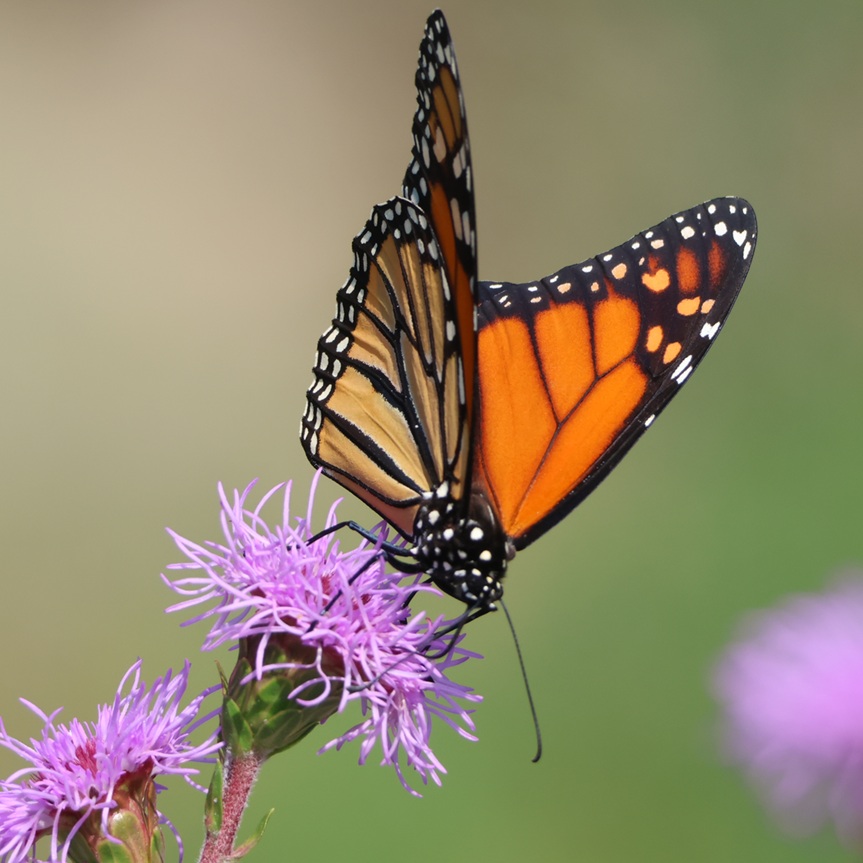
Beyond bees, butterflies are probably the next-most-familiar pollinating insects and this is perhaps the most famous butterfly of all: the monarch (Danaus plexippus). It is pollinating a bloom of a Rocky Mountain blazing star (Liatris ligulistylis), a plant native to the Central Plains of the United States and Canada that grows to a height of 39 inches (100 cm). This guy is one of the reasons I took 150 photographs at the Gardens; this is the best (and it’s not great) of about a dozen that I took of it – the bug just wouldn’t stay still.

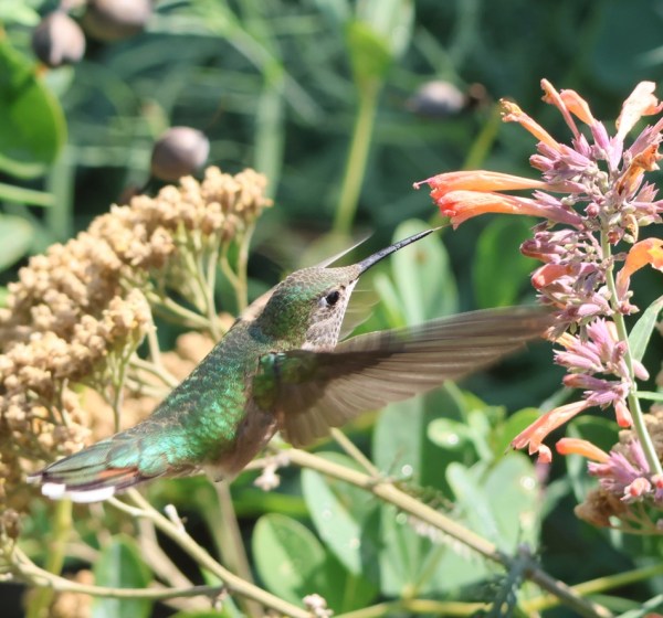
Among non-insect pollinators, hummingbirds might be the most familiar to us but bats, monkeys, lizards, and a few other vertebrate animals do their part to spread pollen around. I first saw this broad-tailed hummingbird (Selasphorus platycercus) hovering in the shade but it quickly moved into the sun so I could get a better picture as it collected nectar from an orange hummingbird mint (Agastache aurantiaca) – you can even make out its super-slender tongue. I heard a lot more hummingbirds than I saw and certainly photographed at the Gardens; male broad-tailed hummingbirds make a trilling sound with their wings as they fly. Broad-tailed hummingbirds are only in the United States from late May through early August; this guy was probably on his way back to Mexico shortly after I took this photo. Hummingbirds, especially Anna’s hummingbirds, are very common in Las Vegas, Nevada, when we winter there, and it was great to be around them again.

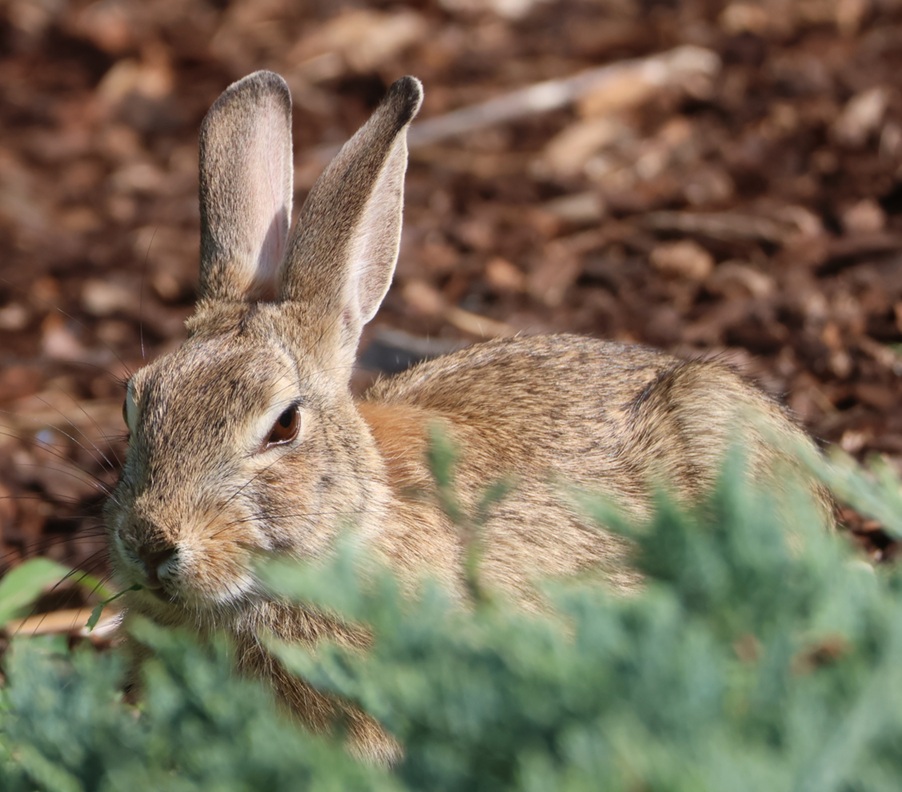
This is not a bee, nor a butterfly, nor a bird, but rather a bunny that I photographed munching on some salad alongside one of the Gardens’ trails. This is most likely a mountain cottontail rabbit (Sylvilagus nuttallii), but another thing I learned while writing this blog posting is that Colorado is home to three (desert and eastern being the others) of the 13 species of cottontails – I previously thought there was just one species.

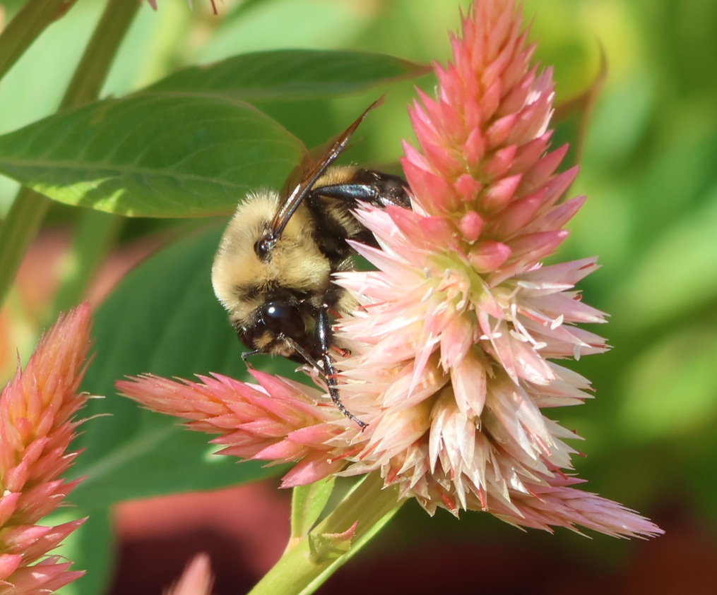
Great black wasps weren’t the only insects enjoying plumed cockscomb at the Gardens – here’s a brown-belted bumble bee (Bombus griseocollis) collecting floral material. These bumble bees live in a remarkably wide variety of habitats and thrive in urban environments – they’ve even been observed at the top of the Empire State Building, 1,250 feet (380 m) above the streets of New York City.

I was taking pictures of house finches (Haemorhous mexicanus) at our front-yard birdfeeders for a couple of years before we became full-time RVers; I’ve since taken several hundred more pictures of them around the country, but this is one of my favorites. She is perched at the top of some species of arborvitae. As the species name suggests, house finches are natives of Mexico and the southwestern United States, but populations were (illegally) taken to the eastern United States in the 1940s and now they’re found in southern Canada, all of the contiguous United States and most of the islands of Hawaii, and most of Mexico. The songs of these pretty little birds are always pleasant to listen to.
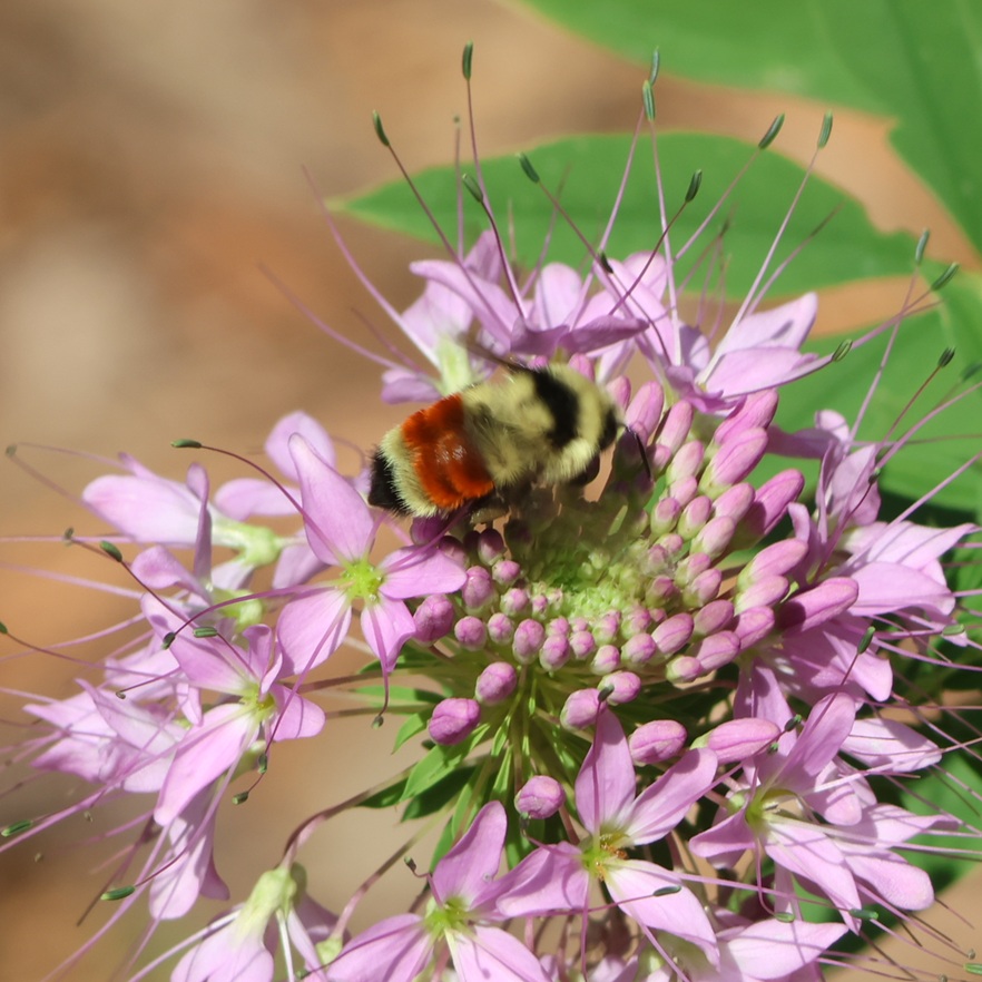
Hunt’s bumble bees (Bombus huntii) are commonly found in the western United States and as far east as Minnesota, as well as regions of Canada and Mexico. Easily identified by the red-orange band on its abdomen, this one is collecting material from a spider flower (Cleome houtteana), which is native to countries in South America. The genus name of bumble bees, Bombus, is Latin for “buzzing” or “booming.”

Apologies if this image destroyed your retinas, but here’s one more western honey bee; it’s on a sneezeweed (Helenium autumnale) blossom. These plants are often used to restore pollinator habitats, encouraging the growth of bee and butterfly populations. The plants are pollinated only by insects, not by the wind, so despite their name they don’t actually contribute to seasonal allergies.

While I departed Denver Botanic Gardens with fewer photographs of birds than I’d planned (I also tried to take pictures of many of the barn swallows swooping above the Gardens’ water features while collecting flying insects, but was thwarted by the swallows’ aeronautics), I came away with a greater appreciation of the diversity of wildlife supported by the Gardens’ native and cultivated plants. I had no idea that honey bees are not native to this country, for example, or how many bumble bee species there were, or that there’s a wasp measuring nearly 1 1/2 inches in length that lives among us. It was a beautiful morning for looking at beautiful plants and wildlife.

Works Consulted

  • Interpretive signage at the Denver Botanic Gardens
  • National Audubon Society Field Guide to North American WIldflowers, Western Region, seventeenth printing
  • National Audubon Society Field Guide to Insects & Spiders, thirty-second printing
  • Wikipedia, accessed August 2026. If you use Wikipedia, please support it

World’s Wonder View Tower

Genoa, Colorado – June 6, 2026

When I was a boy, growing up in the town of Flagler (population: around 600 in the 1980s) in eastern Colorado, there wasn’t much to do in one’s free time but I never got bored.

Flagler was very fortunate to have a movie theater that presented movies on weekend nights, except on those weekend nights when the Flagler Panthers hosted high school football, basketball, and volleyball games since everyone went to those instead of “the Show,” as we called it. That theater, still in operation and sporting a new digital projector and new seating, was where I first saw movies like “Raiders of the Lost Ark” (1981) and “E.T. the Extraterrestrial” (1982), instilling in me a deep and lifelong appreciation of the movies.

For more entertainment, there was a reservoir a few miles east of town that was so full when we first moved to Flagler in 1979 that the lake was overflowing its impoundment dam. It was a favorite destination for eastern Colorado anglers and waterskiers – unthinkable now because, due to agricultural demands for water downstream, the reservoir has been no more than a muddy drainage of the Republican River for many, many years.

I remember my high school chums and I, perhaps after the Show, cruising the six blocks of Flagler’s Main Street in our vehicles on weekend nights by putting the transmission in “D” and taking our foot off the brake. It provided some good times, at three miles an hour.

Much of the lack of boredom of my childhood is due to the many other pastimes available in eastern Colorado: museums, other movie theaters, and attractions like the World’s Wonder View Tower.

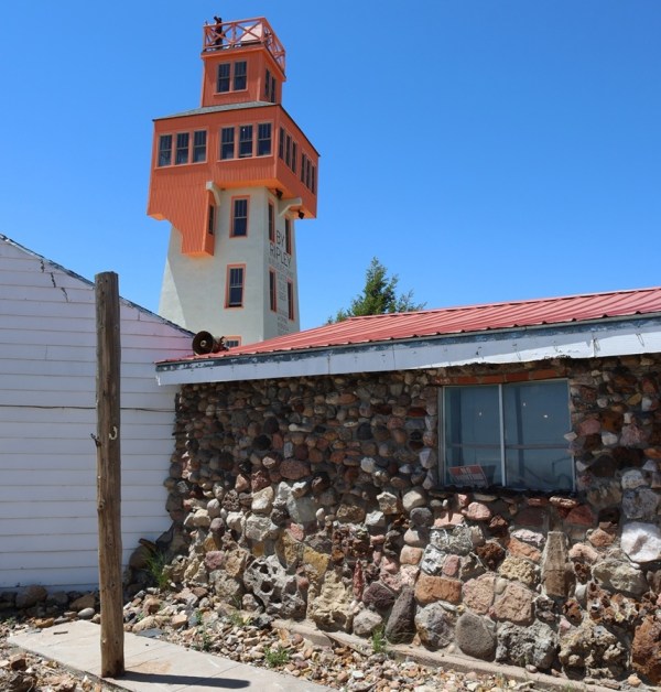
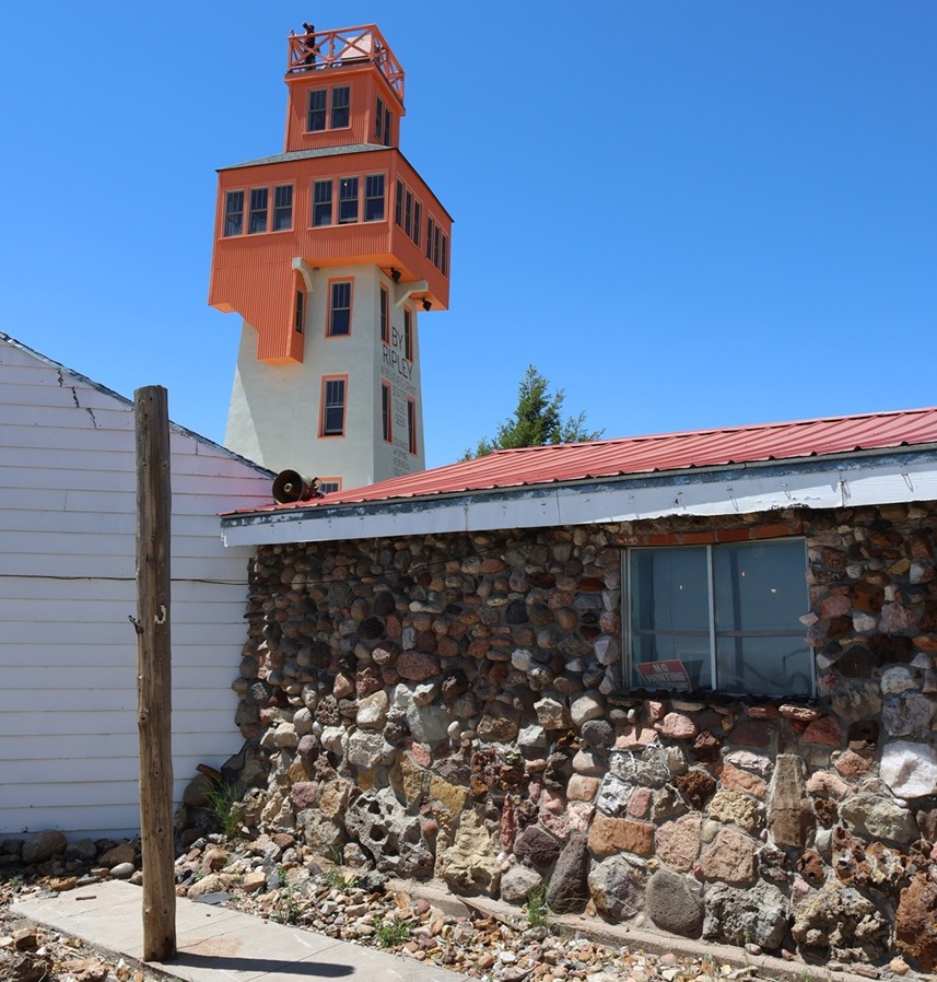
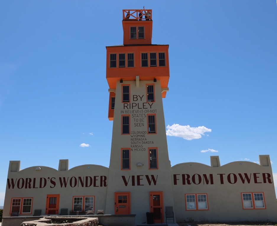
The rock building in the foreground is the museum part of the World’s Wonder View Tower, with the namesake attraction just behind on the left. When I was a boy, the entrance to the museum and the tower was a door just to the right of the window in front. Note the wide variety of rocks used in the building’s construction. Note also a person at the top of the tower; I was to later discover that was either my old Flagler high school chum Gary Beedy, or Gary’s brother, Steve. The Beedy brothers, fourth-generation Genoa-area farmers, are strong supporters of the World’s Wonder View Tower’s restoration and happened to be at the tower the same day we were, and we were pleasantly surprised to see them in the tower’s entrance a few minutes after I took this photo. Eastern Colorado comprises about 40,000 square miles (making it about the size of the entire state of Kentucky), but it can sometimes be a mighty small place.

Located 25 miles west of Flagler in Genoa, Colorado (population in the 2020 U.S. Census: 153), the complex that includes the World’s Wonder View Tower was built in 1926 by Charles Gregory and his partner, Myrtle LeBow. Genoa itself was named after the sixth-largest city in Italy and was located near a natural spring that had attracted wildlife, Native Americans, and Anglo-American explorers to this high spot on the arid plains. Gregory had camped in the area in his younger days, and returned to Genoa to build a top-flight tourist attraction that happened to be right next to a new United States highway.

The decade of the 1920s saw huge growth in the popularity of seeing the United States by automobile, which was further aided by the development of the U.S. Numbered Highway System in 1926. Gregory and LeBow originally built a roadside stop at this location that included a gas station, café, and stage for entertainment. The couple later expanded the amenities to include guest rooms and the 65-foot-tall tower structure.

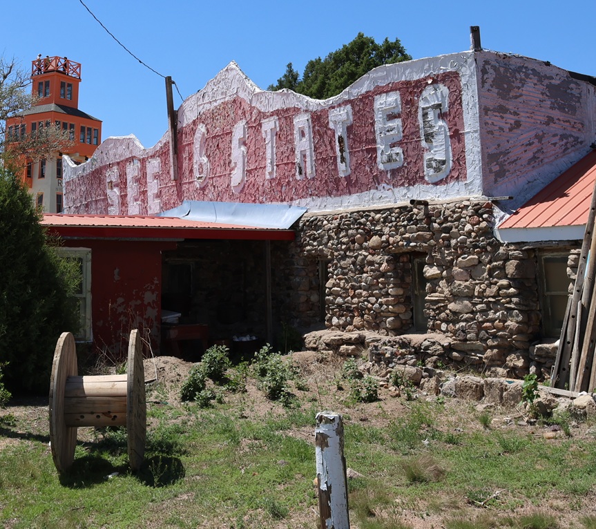
This faded façade is one of my lasting memories of visiting the World’s Wonder View Tower (we just called it “the Genoa Tower,” and no one seemed confused about what we were discussing). The current stewarding organization of the tower complex has focused its efforts on restoring the World’s Wonder View Tower itself, and rightly so.

When completed, the World’s Wonder View Tower, which begins at Genoa’s elevation of 5,604 feet (1,708 m) was the highest point between the Palmer Divide of the Rocky Mountains to the west and the mountains of the eastern United States. The tremendous height of the tower affords simply spectacular views in all directions of the compass.

In 1933, no less an authority than Ripley’s Believe It Or Not confirmed that six states – Kansas, Wyoming, South Dakota, Nebraska, New Mexico, and, of course, Colorado – could be seen from the top of the 65 tower. Our tour guide on our June 2026 visit, who accompanied our group to the top, used the word “technically” fairly often when she spoke about the opportunity to see a half-dozen states, such as “Technically, you can see South Dakota.” I finally said “You’re throwing the word ‘technically’ around quite a lot …” and she responded with the expected (and I’m paraphrasing), “We just don’t want to wind up in litigation.” Completely fair, I think.

This picture was taken from the east side of the World’s Wonder View Tower. The tower’s original entrance was here on the east side because U.S. Highway 40N (which would be redesignated U.S. Highway 24 in 1936) passed by the tower a few yards to the north. In the 1970s, with the development of Interstate 70 south of the tower, the attraction’s entrance was moved to the south side for easier accessibility. When restoring the tower, the entrance was re-located back to this side of the building. I believe that’s Gary and Steve Beedy still at the top of the tower; I don’t know if they could see the six states of Colorado, Wyoming, Nebraska, South Dakota, Kansas, and New Mexico, but they could almost certainly see their farm located a few miles north of Genoa. Gary and Steve’s great-grandparents first homesteaded the farm in 1893, 33 years before Gregory and LeBow began building this attraction.

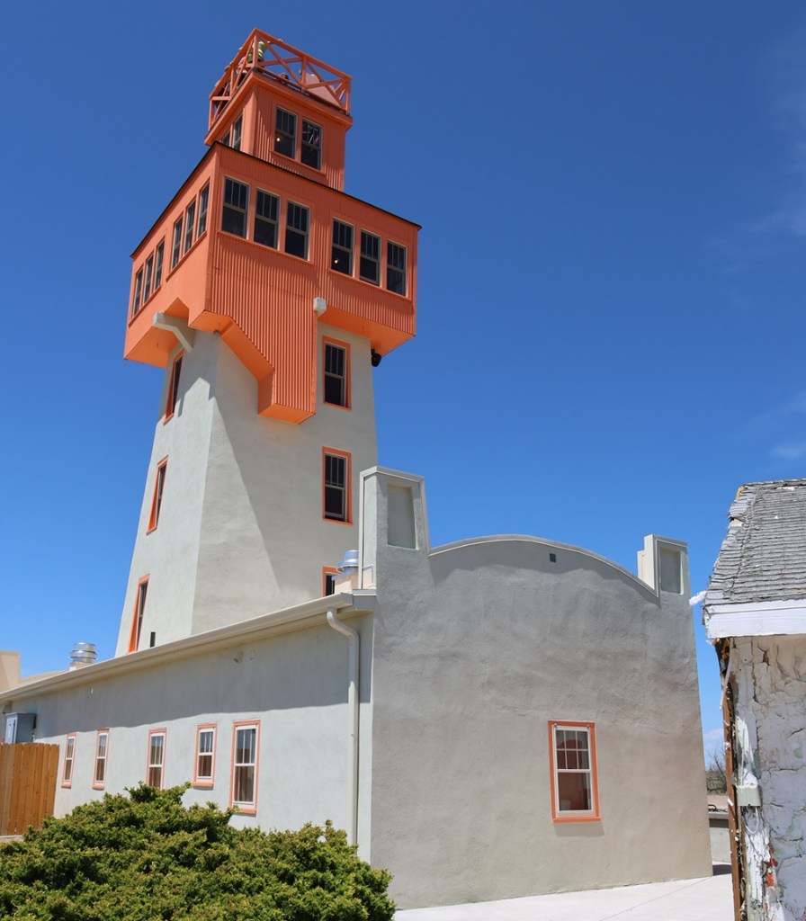
Here’s a look at the 65-foot-tall World’s Wonder View Tower from its southwest corner. Jerry Chubbuck built an apartment for his family that connected the building on the left with the one on the right; See Six States LLC restored the two buildings to their original and individual states. The new paint job, based on historic photos of the buildings, looks fantastic.

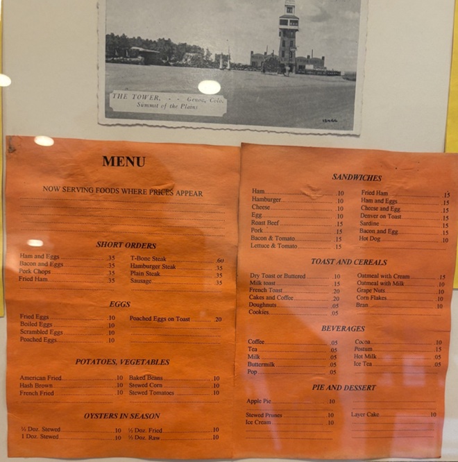
In a frame and behind glass inside the tower’s entrance, here are a postcard (“THE TOWER – – Genoa, Colo. Summit of the Plains”) and a menu from when the tower had a café. Nancy and I both wondered about the provenance of OYSTERS IN SEASON. I wouldn’t pass up a piece of apple pie, though, especially at 10 cents.

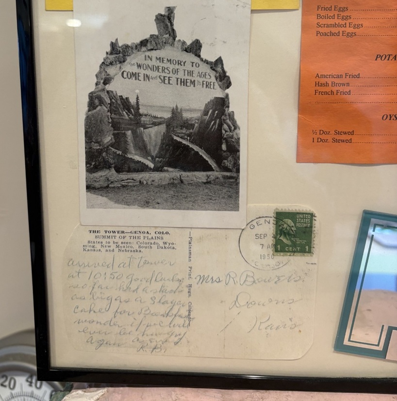
To the lower left of the menu, here are a couple more historic postcards. The bottom one, which has a Genoa (Colorado, not the capital of Liguria in Italy) postmark of April 7, 1950, is addressed to Mrs. R. Bowers of Downs, Kansas (located in the north-central part of the Sunflower State), and reads: “Arrived at tower at 10:50. Good luck so far. Had a stack” (presumably of pancakes, although they’re not on the menu pictured above) “as big as a 5-layer cake for breakfast, wonder if we could ever be hungry again.”

This is a picture of a picture at the tower’s entrance of Jerry Chubbuck (October 22, 1930 – August 4, 2013), who owned the World’s Wonder View Tower from 1967 until he passed away. Jerry, who was born in Arriba, Colorado, about 13 miles east of Genoa, was a fascinating person with wide-ranging interests in archeology, geology, paleontology, Native American cultures, and more. He converted the tower’s overnight guest rooms, café, and other rooms into a winding museum that was sort of overwhelming in its scope. It contained exhibits of thousands of arrowheads, dozens of telegraph and telephone line insulators, mammoth fossils (that he discovered), a taxidermied two-headed calf, World War I and World War II-era military memorabilia, petrified wood samples and other rock collections that went on forever, old and obscure farm and ranch tools and machinery, and much more. Jerry had stories about nearly everything under the museum’s roof, and I have fond memories of Jerry greeting visitors at the front door, collecting one dollar in admission, and then offering to refund their dollar if they could guess what historic artifact (usually some sort of old and obscure farm tool or implement) he happened to be holding in his hand. I’m here to tell you: there were some weird and specialized things manufactured in the old days, and I never, despite Jerry’s patience and hints, got my dollar back from any of my visits. Under Jerry’s stewardship of the Genoa Tower, it became a pretty famous landmark along Interstate 70. My other lasting memory of Jerry, who obviously loved sharing his knowledge with others: after telling you what some artifact was and how to use it, he’d end his sentences with, “Yep. Uh-huh. R-i-i-i-ght.” I think the world needs more people like Jerry Chubbuck.

Jerry passed away in 2013, and the site fell into disuse for several years until some Colorado history aficionados, determined to save the property from fading from the map, formed a limited liability corporation (enigmatically called “See Six States LLC”) to acquire the tower and surrounding buildings and land. See Six States LLC put the property in the hands of a nonprofit group called Friends of the Genoa Tower, the board members of which include Patricia Calhoun, who co-founded the Denver alternative weekly newspaper Westword in 1977 and was, until her pending retirement in the summer of 2026, the newspaper’s editor-in-chief. Troy McCue, another high-school chum of mine, is also a member of the Friends of the Genoa Tower board; he’s now the executive director of Lincoln County Economic Development, which promotes and maintains job creation and business growth in this eastern Colorado county in which Genoa is located.

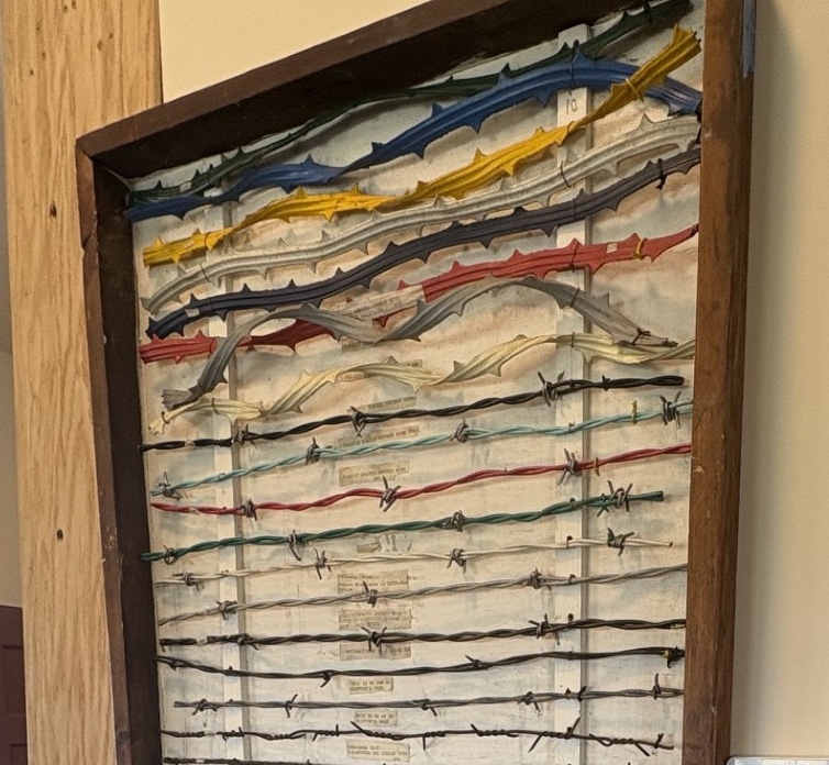
Much of Jerry’s museum collection was sold at public auction, so the two-headed calf and fossilized mammoth bones and most of the other items have found new homes all around the world (although word on the street is that there is an effort to retrieve some of the curiosities, but you didn’t hear that from me). One item that thankfully didn’t get spread to the four winds is this fine display of barbed wire, exhibited in the tower’s gift shop. Regular readers of this blog will know that I will spare no effort to post pictures of any worthy museum’s barbed wire exhibits and I’m rather unapologetic about it, so here you go.

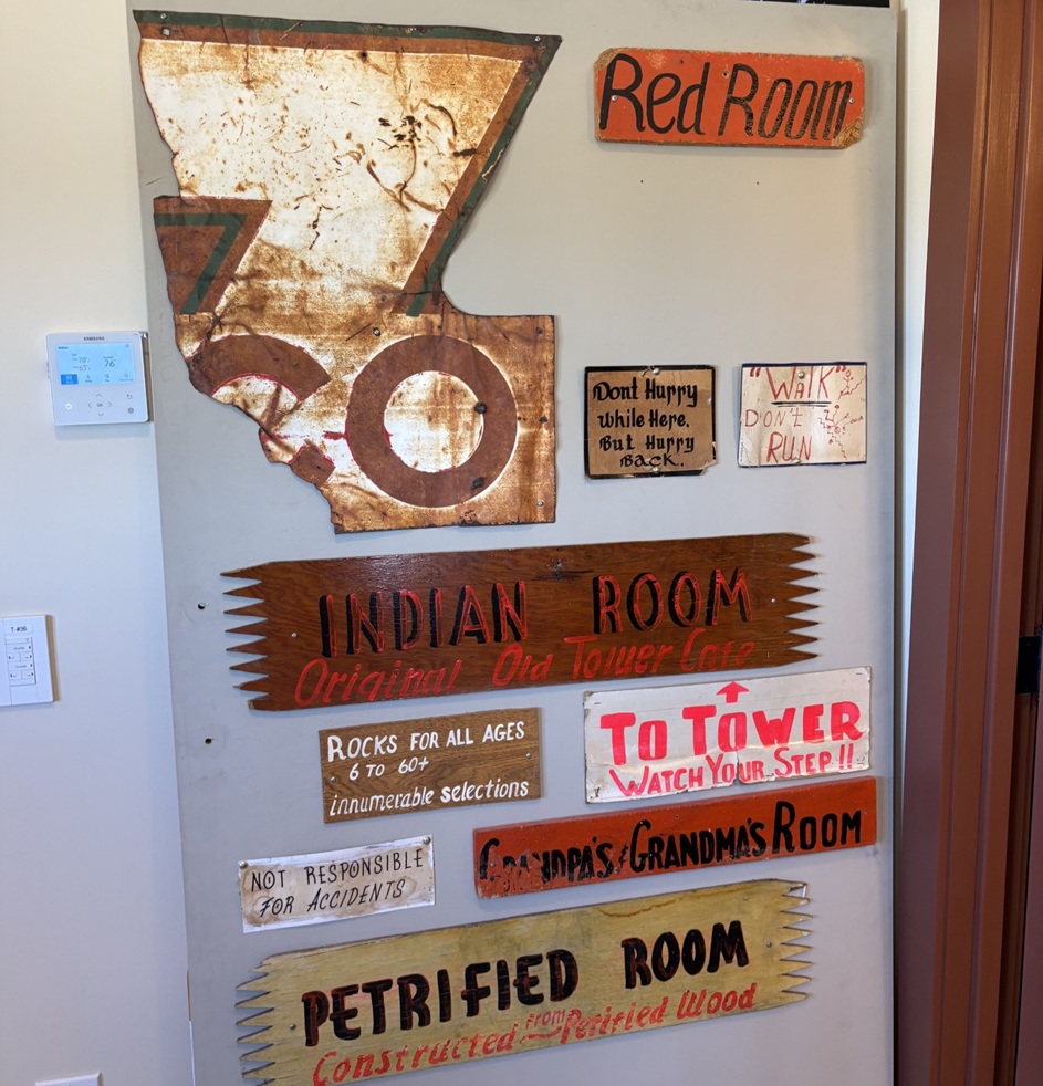
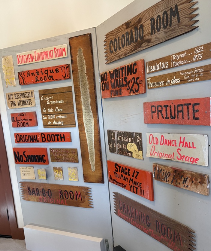
Fortunately, some of Jerry Chubbuck’s hand-painted museum signage, much of which identified the attraction’s many different rooms and warrens, was also withheld from the public auction and is now on display in the tower’s gift shop. I remember seeing some of these signs 40 years ago, and it was good to see them again.

There were a lot of museum rooms (I want to say there were at least 20, but my memory may be faulty and it might have been more than that), and they all needed to be identified with signs. The sign at lower right, “Branding Room,” identified the room as containing the “Biggest Collection of Irons in the West.” I have no doubt that it was. Also of note: the signs announcing more than 20,000 “ancient arrowheads of this area” on display and “No Writing on Walls; Fine: $25.”

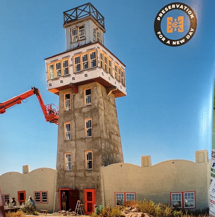
This is a picture of a cover of one of History Colorado State Historical Fund’s annual reports, showing progress of the World’s Wonder View Tower restoration. The project, heavily financed by grants from the state’s historical fund but also with significant contributions from other donors from all around the state and local area, needed more than $3 million in funds for completion. See 6 States LLC and Friends of The Genoa Tower have some really exciting plans for the property, including its usage as an art gallery space and a venue for event functions. The property celebrated its grand reopening in early May of this year. From the standpoint of someone who visited it back in the day and then again this spring, it’s a very impressive transformation that has some great possibilities in front of it.

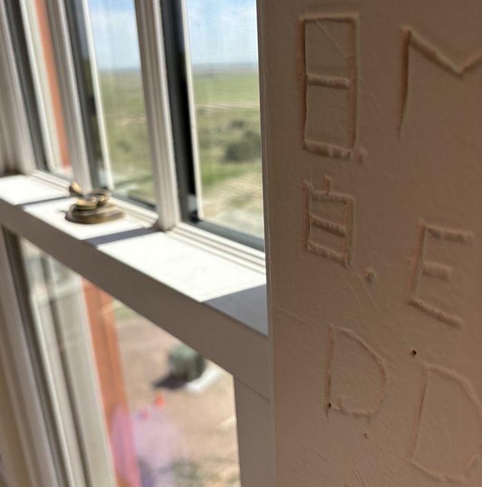
Despite the threat of a $25 fine, many miscreants decided to leave graffiti on the tower’s walls as they ascended to the top. See 6 States LLC, in restoring the tower, made the right choice to leave the graffiti in situ while putting another coat of paint on the walls. This photo was taken from one of the tower’s staircases, looking southwest through a historic window.

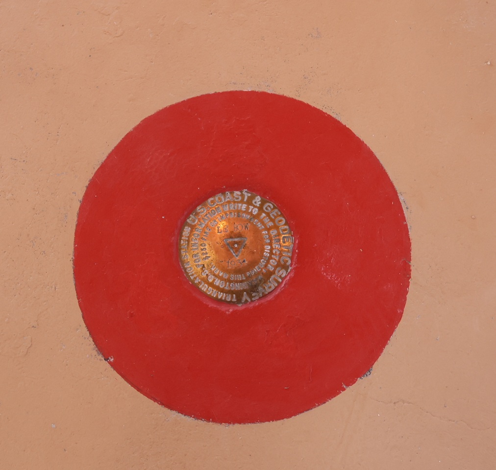
The United States Coast & Geodetic Survey placed this geodetic marker in the floor of one of the tower’s upper rooms in the 1930s, confirming the latitude, longitude, and, most importantly, the elevation of the World’s Wonder View Tower. Note the name “LeBow” (as in Myrtle) and the year, 1934, in the center of the disk. The USC&GS existed from 1807 until 1970, when it and several other government agencies became part of the National Oceanic and Atmospheric Administration (NOAA). People who hike a lot may have seen these markers on trails, used to compile accurate survey information with exact latitudinal, longitudinal, and elevation points on the surface of the Earth. This was the first one I’d seen that was about 50 feet off the surface of the Earth.

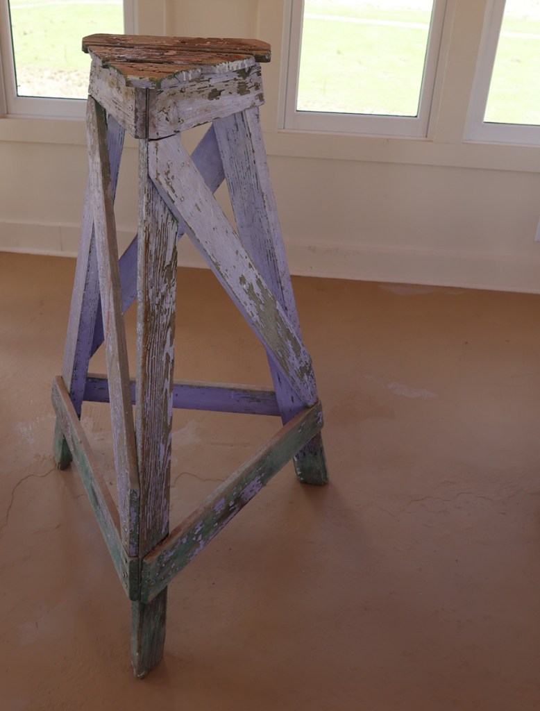
The government surveyors used this wooden tripod, which they assembled in the tower room containing the geodetic marker, to precisely place the metal disk in the floor of the tower room in 1934. After the project’s completion, they attempted to take the tripod back down the tower’s stairs, only to find that the tripod’s legs were too wide to be transported down the narrow staircases. So, here it has stood for nearly a century, getting a new coat of paint every now and then.

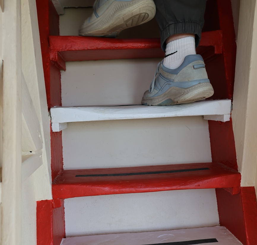
When I was a boy, the staircases in the tower, especially this final one leading to the viewing platform at the very top, could charitably be called “rickety.” See Six States LLC reinforced all of the staircases during the redevelopment, and the climb to the top and the viewing platform are rock-steady now. Happily, the group elected to keep the time-worn steps themselves; one wonders how many shoes have been on these steps in the last near-century. Those are Nancy’s shoes at the top of the photo; she and I had been at the top of the tower together a short time after we met when the Genoa Tower was still under the stewardship of Jerry Chubbuck, so she’s a seasoned veteran of the climb. Are you ready to discover what being at the top of the World’s Wonder View Tower looks like? Just follow Nancy!

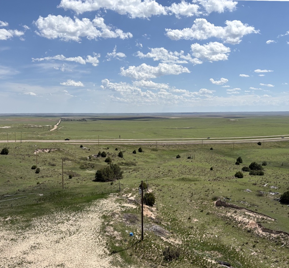
Taken from the top of the World’s Wonder View Tower, this viewpoint looking east-northeast shows the town of Genoa and then (“technically”) the states of Kansas and Nebraska beyond. Genoa’s water tower and grain elevator, both of which are predated by, and taller than, the World’s Wonder View Tower but you probably aren’t allowed to climb to the their respective tops, can be seen in center-right. You’d think that Genoa, Colorado, would be pronounced the same as the city in Italy (“JEN-oh-uh”). You’d be wrong: it’s pronounced “jen-OH-uh.” Now you know and can impress your friends with your newly acquired worldly knowledge, which, come to think of it, I probably should have shared before nearing the end of this posting.

This perspective from the top of the World’s Wonder View Tower is looking directly south. On the other side of the cedar trees is Interstate 70, then about 20,000 square miles of Colorado farm- and ranchland, then (“technically”) New Mexico. It was a little hazy on the day of our visit, but the views were still really spectacular.

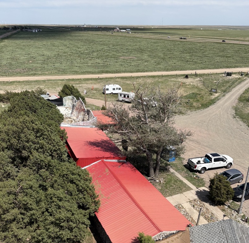
This is a view from the top of the tower looking to the southeast. That’s again Interstate 70 near the horizon and (“technically”) Kansas beyond. Being 65 feet above the ground gives an interesting perspective to your surroundings, such as seeing some parts of the landscape under the darkness of cloud cover. The red roofs are the historic buildings of the World’s Wonder View Tower, where the café and overnight guest rooms, and later Jerry Chubbuck’s museum, were located. Just above them is the back side of the white-and-red “See 6 States” façade shown earlier. The white Ford F-350 Super Duty is Ol’ Blue, the Goddard’s six-wheeled towing unit. Just visible above the tree to the left of Ol’ Blue is a small travel trailer. That’s our first camping trailer, the predecessor to The Goddard, which we called “The Riglet” because bigger camping trailers and motor homes are sometimes called “rigs.” The Riglet is now owned by our friends Mary and Robert, whose company we enjoyed at the World’s Wonder View Tower and then they joined us in the Arriba campground in which we were staying for more fellowship.

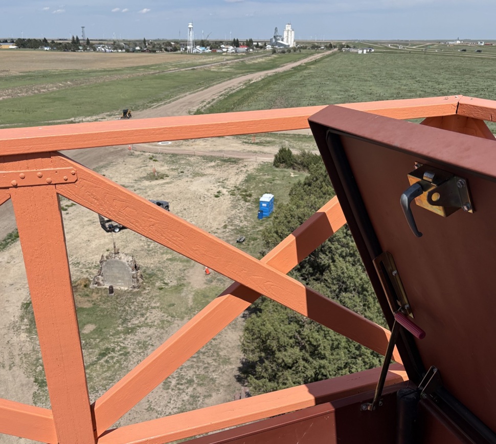
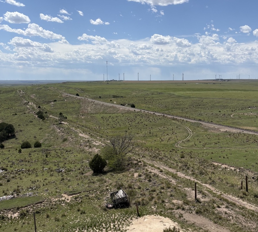
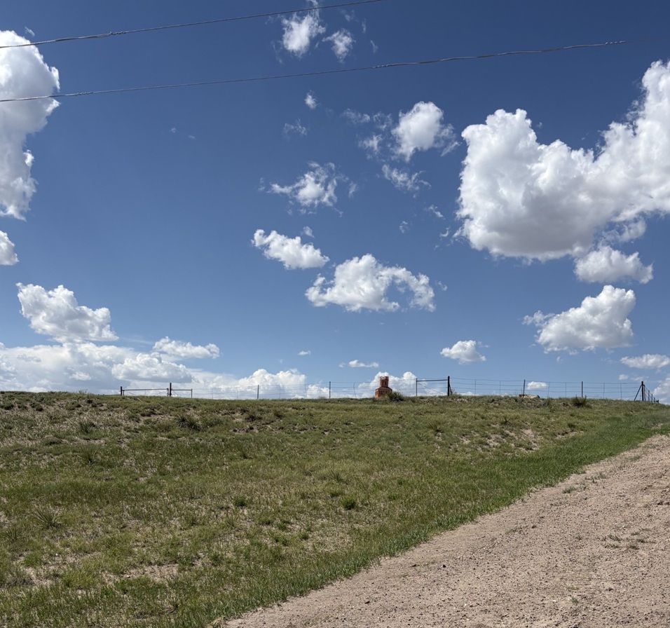
One last view from the top of the tower: this is looking northwest, so Denver is presumably somewhere on the horizon. There’s a radio tower on the horizon just left of center and most of the rest of the tall structures are wind turbines. The dependable winds available in eastern Colorado are quickly making the area an important location for renewable energy generation. The railroad bed and rails, still in use today, can be seen in the center of the picture, and just to the right of the tree in lower center is a dirt road that is the remnant of the old U.S. Highway 24 which, until the completion of Interstate 70 in the 1970s, brought people by the tens of thousands to the World’s Wonder View Tower.

Goodbye until we see each other again, World’s Wonder View Tower! I look forward to seeing what your next hundred years will bring.

Valle de Oro National Wildlife Refuge

Albuquerque, New Mexico – May 9, 2026

Located just seven miles south of Albuquerque, Valle de Oro National Wildlife Refuge (NWR) was established in 2014 as the first urban NWR in the American Southwest. One of nearly 600 national wildlife refuges in the United States, Valle de Oro is adjacent to Rio Grande Valley New Mexico State Park, which is next to the Rio Grande (there’s no “River” after the name because “rio grande” means “big river” in Spanish, so it’d be like writing “big river river”). Through the National Wildlife Refuge System, a number of different ecosystems, including wetlands, prairies, forests, and coastal areas, are protected from development in order to provide habitats in which wildlife and plants can thrive.

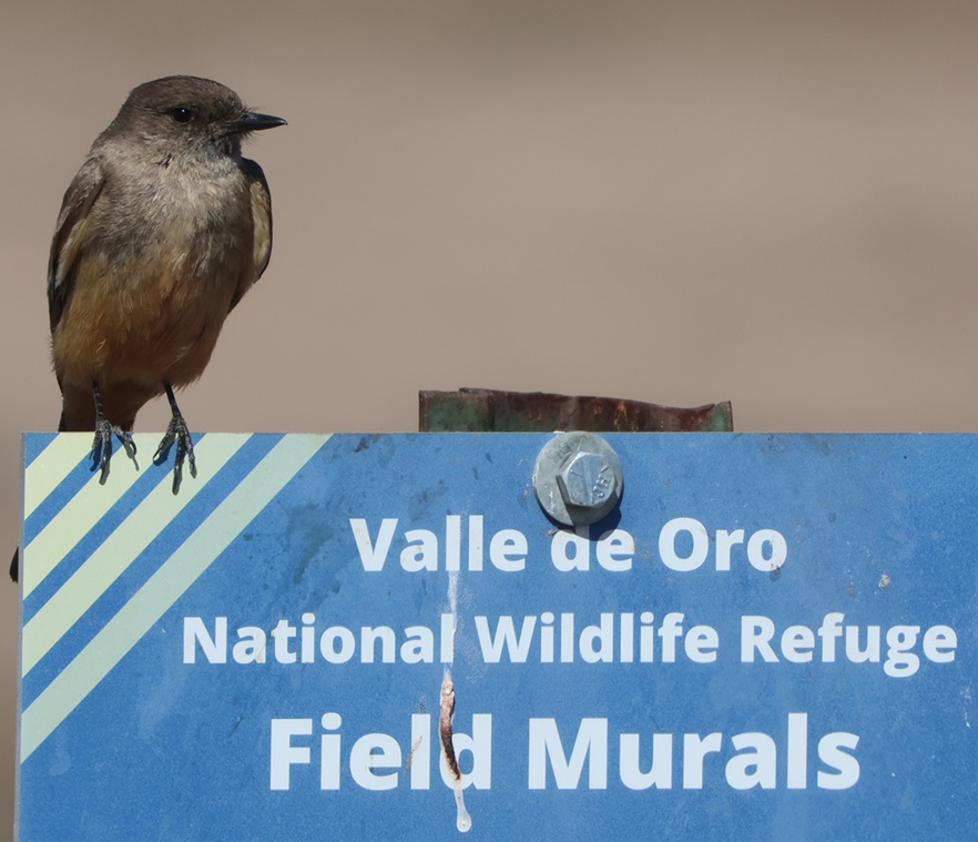
This Say’s phoebe welcomed us to the start of a hike at the refuge called the Valle de Oro Bosque Loop. “Bosque” (pr. boss-KAY) is Spanish for “forest,” and it refers to the many trees, mostly cottonwood, that line the banks of the Rio Grande just on the other side of the refuge’s western boundary.

In the case of Valle de Oro NWR, the refuge isn’t protecting undisturbed habitat that’s threatened by commercial development but rather restoring natural habitat from a formerly developed state.

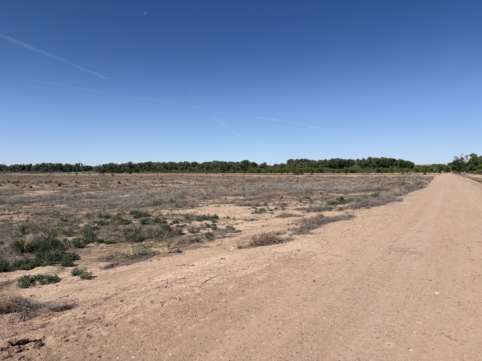
This is near the trailhead of the Valle de Oro Bosque Loop. The Rio Grande doesn’t pass through Valle de Oro NWR, but rather on the western side of the refuge. You can probably tell, from the cottonwoods on the horizon, where the water from the river regularly reaches.

Because of the ongoing drought in the American Southwest, the Rio Grande can’t even realistically be called “big”; while we were in Albuquerque in May, the river was barely a trickle as it ran through the city. When not impounded and when historically normal moisture is available, the Rio Grande flows 1,896 miles from its headwaters in southwestern Colorado, through New Mexico, forms the southern border of Texas, and empties into the Gulf of Mexico. The Rio Grande is the fourth-longest river in the United States.

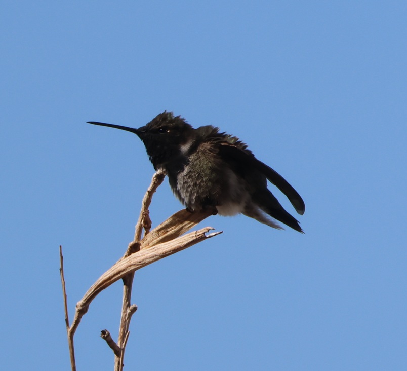
This black-chinned hummingbird (Archilochus alexandri) was making itself more comfortable on a perch just outside the front door of the refuge’s visitor center. The average heartrate of these little birds is 480 beats per minute, and in cold weather they may eat three times their body weight in flower nectar per day. They have body lengths of 3.5 inches (9 cm), weigh 0.1-0.2 ounces (2.3-4.6 g), and their wingspans measure 4.3 inches (11 cm). For comparison, a United States nickel minted in 1965 or later weighs 0.176 ounces (5 g). In good habitats, like along a river, a black-chinned hummingbird nest may be found every 100 yards (91 m) or so; their eggs are the size of coffee beans. Male black-chinned hummingbirds have a really vibrant swath of iridescent purple feathers on their chins, but those only appear when the sun hits them just right.

The 570-acre (just under one square mile) protected area now known as Valle de Oro NWR has a long and interesting history going back many centuries, and counts Pueblo Native Americans, Spanish conquistadors, and dairy and alfalfa farmers as those who have used its resources.

Valle de Oro NWR is among the ancestral and current lands of the Tiwa People, a Pueblo culture of Native Americans in what is now the Albuquerque area. Some of the Tiwa currently live in the Isleta and Sandia pueblos, two of New Mexico’s 19 Native American pueblos. The Pueblo culture initially developed between the years 700 and 1100, and particularly thrived between 1100 and 1300. Both Isleta and Sandia were established as pueblos in the 14th century; they were known by their Tiwa names until the Spanish arrived in the area in the late 15th century. “Isleta” and “sandia” are Spanish for “little island” and “watermelon,” respectively (more on “sandia” further down).

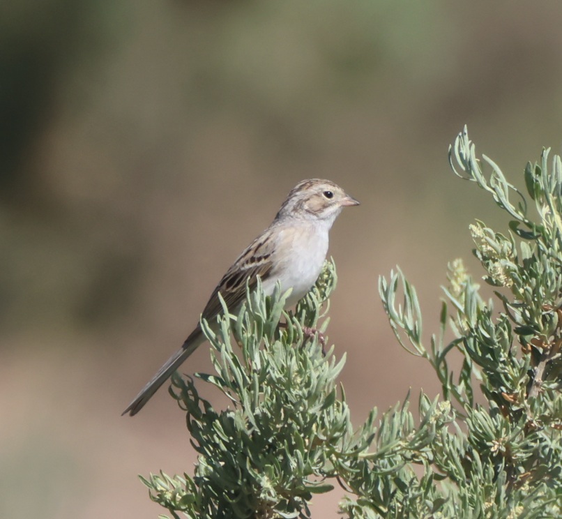
Nancy’s very good at spotting birds in the wild, and she pointed out a pair of these Brewer’s sparrows (Spizella breweri) that were perched at least 50 yards away on a sagebrush. Their size differs depending on their regional habitats, but in general Brewer’s sparrows are the smallest sparrows in North America with weights of 0.4-0.5 ounces (11-14 g). Because of a lack of defining coloration, markings, or other identification characteristics, these sparrows show why birding enthusiasts came up with the acronym of “LBB” for “little brown bird,” to serve as a temporary moniker of an individual bird until positive identification can be made.

The Spanish established a major road, El Camino Real de Tierra Adentro (“the royal road of the interior land”), that extended 1,590 miles (2,560 km) from Mexico City to just north of Santa Fe in present-day New Mexico. The road, one of four that connected Mexico City to the resources of the vast Spanish colony in America, was used from 1598 to 1882 to transport soldiers and trade goods. Much of El Camino Real still exists in the form of state highways and county roads (it passes right by one of our favorite restaurants in Las Cruces), and, back up near Albuquerque, it forms the eastern border of what is now Valle de Oro NWR.

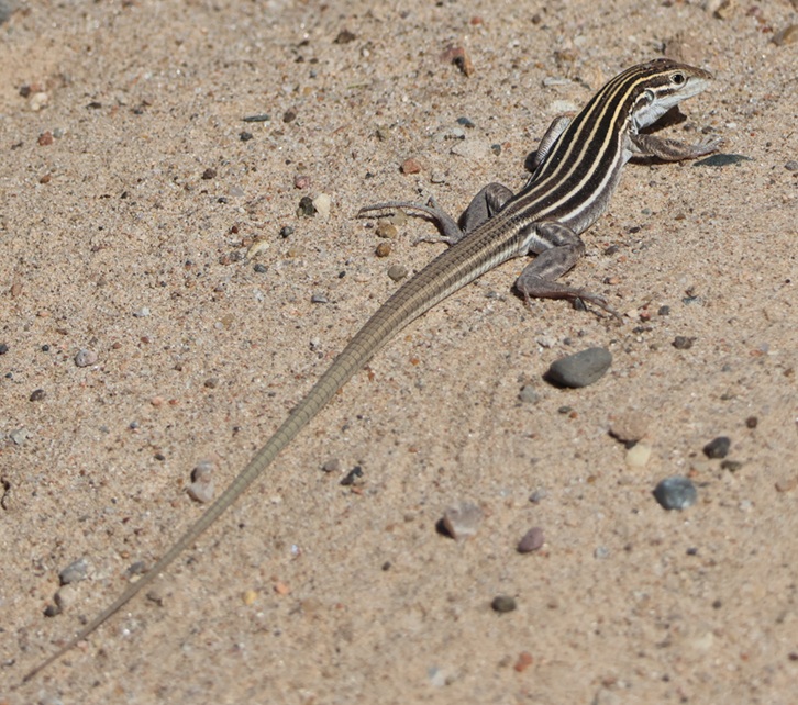
THIS IS A TALES OF THE GODDARD LIZARD ALERT. Desert grassland whiptail lizards (Aspidoscelis uniparens) live along the Rio Grande in New Mexico and in southern to central Arizona, as well as in northern Mexico. Their tails are longer than their bodies, which measure 2 3/4 to 5 1/4 inches (7.0-13.3 cm) long. They are easily identified by the six yellow stripes extending from the head and along the body. Desert grassland whiptails eat a variety of insects and other invertebrates, including ants, termites, beetles, butterflies, and grasshoppers.

Time passed, and, when Mexico gained its independence from Spain in 1821, Albuquerque changed from a New Spain outpost into a Mexican city. Albuquerque and the rest of the American Southwest became part of the United States in the mid-19th century and, in the 1930s, a family with a dairy in El Paso, Texas, expanded their operations to include a tract of land near Albuquerque. The family named the dairy “Valley Gold,” which you might, and correctly, infer (roughly) translates in Spanish to “valle de oro.” Following an increased demand for milk in the southwest after World War II, Valley Gold expanded its herd to 1,600 cows, making it one of the largest privately owned dairies in the country. The U.S. Department of Agriculture records that an average dairy cow in 1950 produced 5,300 pounds of milk each year (in 2025, an average dairy cow produced 24,400 pounds of milk annually; the industry has certainly gained some efficiencies). Anyway, dairies use a lot of water, so the Valley Gold operation developed substantial irrigation infrastructure using water from the nearby Rio Grande.

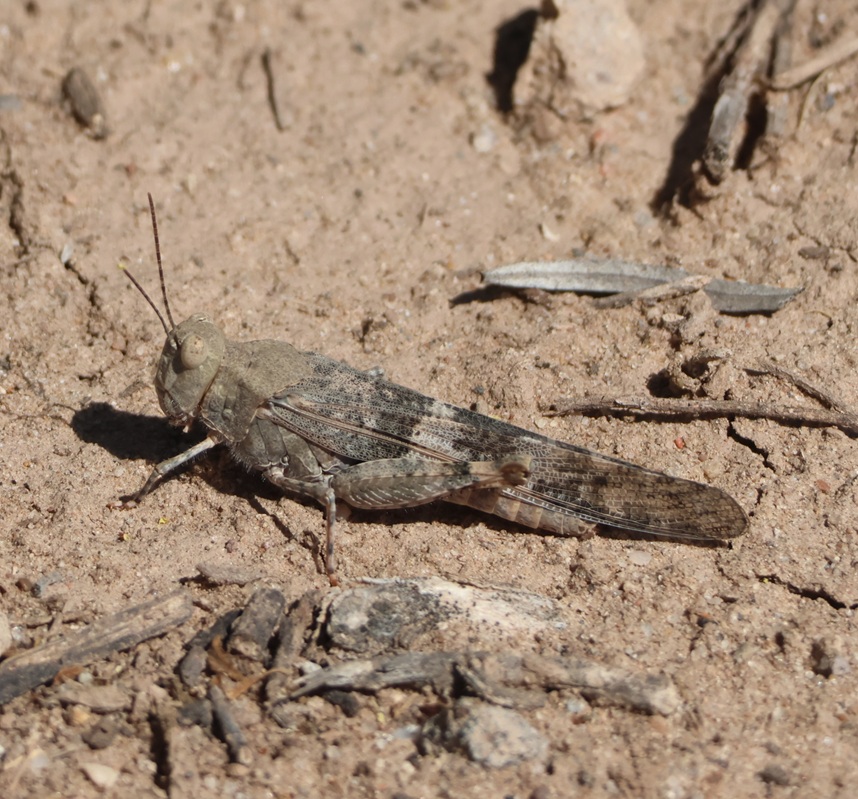
There were quite a few grasshoppers jumping about the trail as we walked. This is a pallid-winged grasshopper (Trimerotropis pallidipennis), a species common in the American Southwest. They grow to a length of 1 1/2 inches (37 mm), and their pale coloration makes for good camouflage in the dry riverbeds that they frequent.

Valley Gold ceased operations in the Albuquerque area in the late 1970s, and the property operated as an alfalfa farm (which also required a lot of water) for some time until the land was put up for sale and probable commercial development. A group of residents in the area formed Friends of Valle de Oro, a nonprofit organization that raised $9 million to buy the property and then partnered with the U.S. Fish & Wildlife Service to create the southwest’s first urban national wildlife refuge. What had been home to Pima People, part of the route from Mexico City to Santa Fe, then a dairy and alfalfa farm, was now ready to welcome back dozens of species of birds, mammals, and other wildlife to an area protected from commercial development.

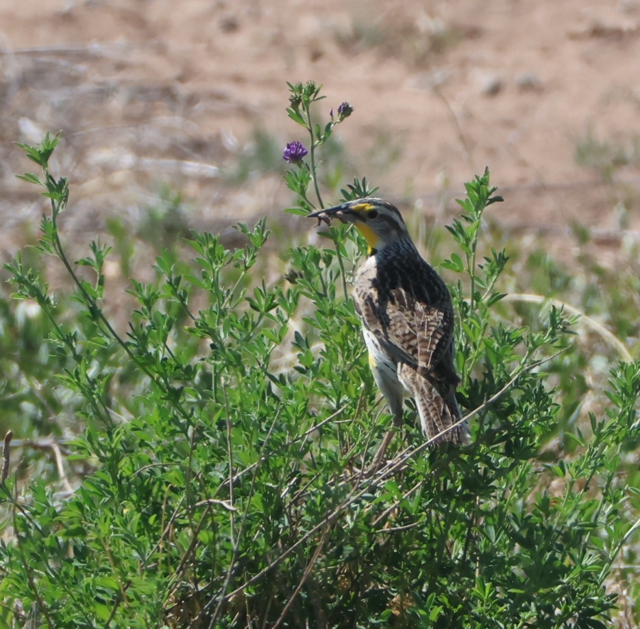
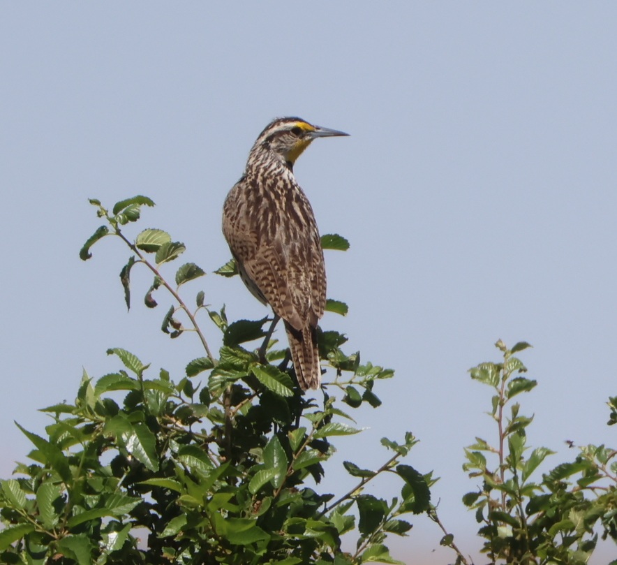
Here’s a photo of another grasshopper; this one finds itself in the unfortunate position of being in the beak of a western meadowlark (Sturnella neglecta). No less a naturalist than John James Audubon gave this bird its scientific name: “sturnella” means “starling-like,” and “neglecta” refers to Audubon’s belief that this species was overlooked by 19th-century ornitholgists. The plant on which the meadowlark is perched points to the refuge’s past: it’s alfalfa, which, due to its high protein content, comprises up to 50 percent of a dairy cow’s diet. Although the irrigation systems that served the dairy and alfalfa farms that once occupied this land are long out of use (the canals are filled with blown dirt and sand), some alfalfa plants still found enough water to thrive and bloom.

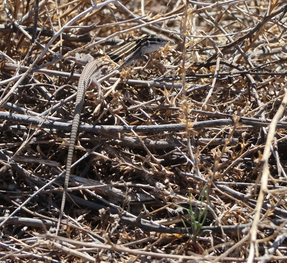
THIS IS ANOTHER TALES OF THE GODDARD LIZARD ALERT and it’s another desert grassland whiptail. They’re well-camouflaged in dry desert brush like this.

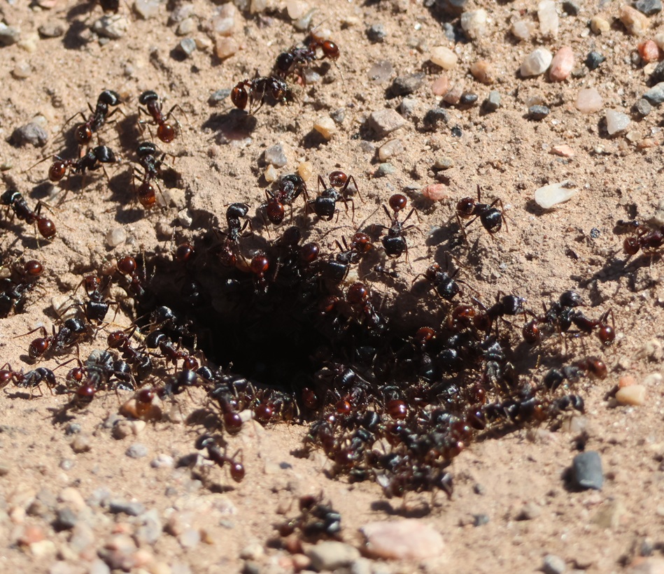
Albuquerque is at the northern edge of the Chihuahuan Desert, and here was a reminder that deserts have lots of sharp things like cactus thorns and ant mandibles. At one point on the trail, we stopped because Nancy had seen a bird drop from a low branch onto the ground and was attempting to spot it. I told her not to back up. lest she step into this. It’s a colony of desert harvester ants (Pogonomyrmex rugosus), which have powerful jaws and very painful venomous bites. These ants use pheromones to create invisible trails that enable other ants to follow to the colony, bringing with them plant seeds and dead insects. A few minutes before, I noticed a couple of small leaves moving on the trail in the same direction we were walking even though there wasn’t a breeze. The leaves were being carried by two harvester ants, presumably from this colony. We left the colony and continued on the trail without incident.

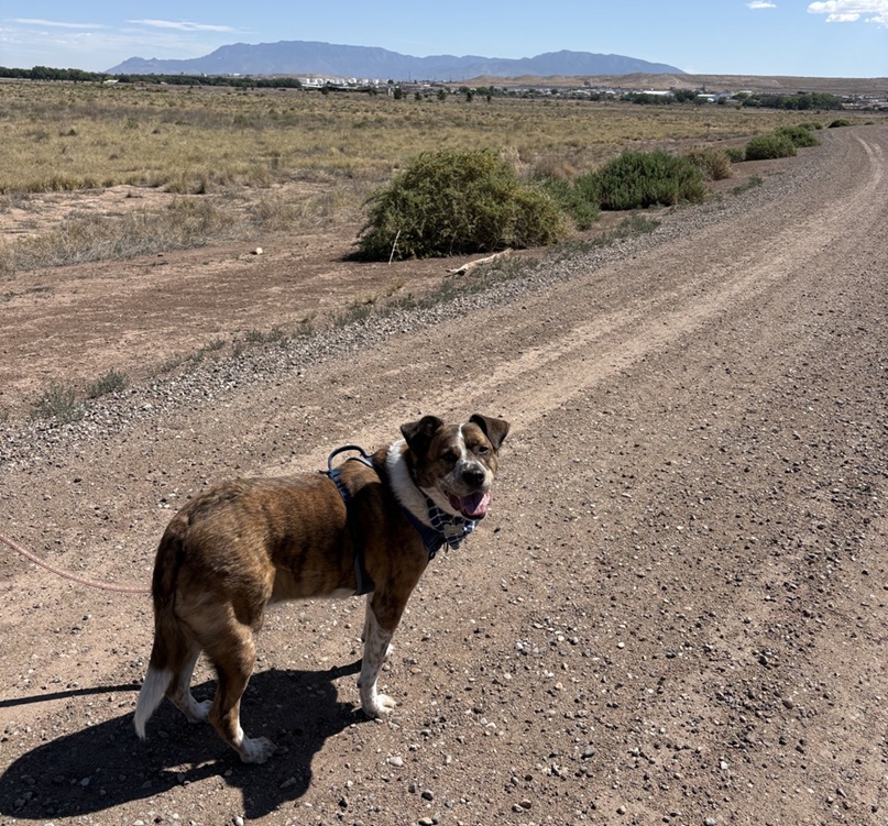
Here’s Gunther, who enjoyed the walk with us, and here’s what much of the terrain of the Valley de Oro Bosque Loop looks like, at least away from the parts connected to the Rio Grande. Because it was used for so many decades as a dairy and later an alfalfa farm, there aren’t as many native plants as there are in other parts of the desert around Albuquerque – when water stopped being diverted from the Rio Grande, the land essentially dried up. Volunteers and NWR staff are hard at work changing that, with plantings of trees and other native plants. The buildings just this side of the mountains are in Albuquerque, and the mountains themselves are the Sandias. They rise to a top elevation of 10,678 feet (3,255 m) and are New Mexico’s most-visited mountain range. Spanish explorers gave the mountain range the name “sandia” because they seem to glow pinkish-red, like a watermelon, during Albuquerque sunsets.

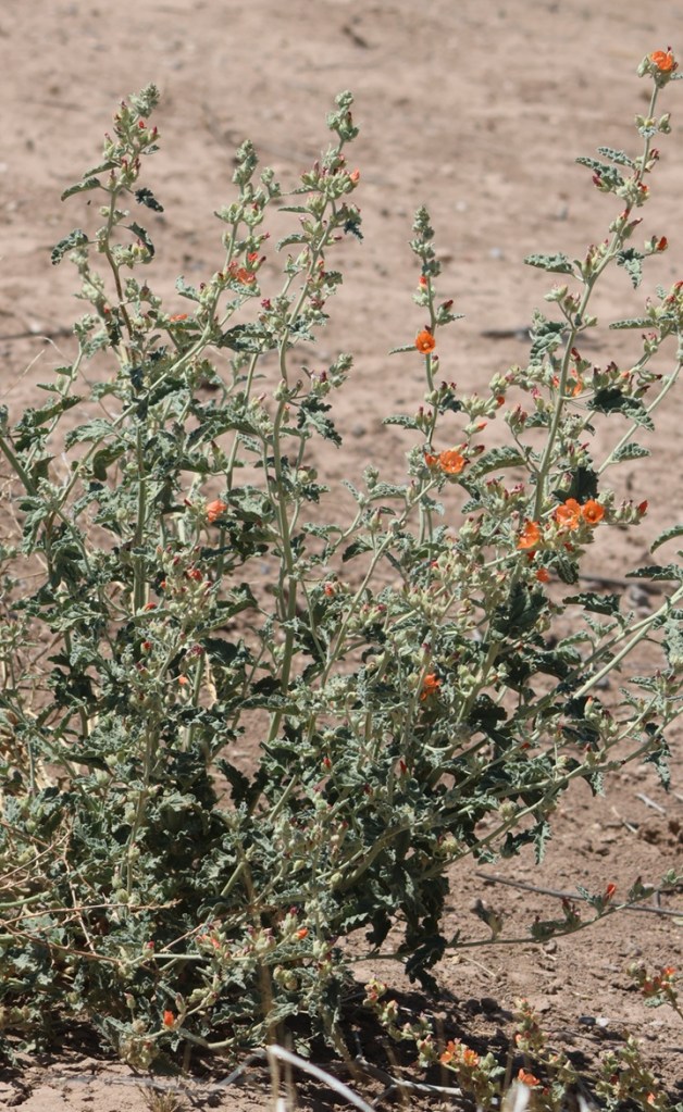
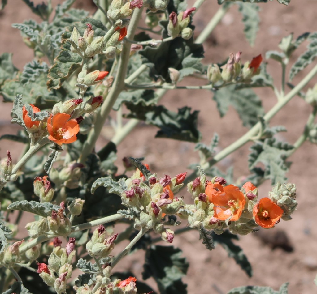
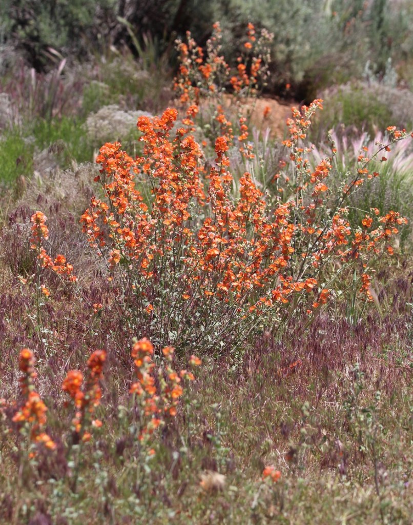
The mission of the National Wildlife Refuge System is “To administer a national network of lands and waters for the conservation, management, and where appropriate, restoration of fish, wildlife, and plant resources and their habitats within the United States for the benefit of the present and future generations of Americans.” Here’s an example of the plant resources: desert globemallow. Its coral-colored flowers are an extremely familiar sight to anyone in the desert southwest. I remember on a drive to the north rim of the Grand Canyon in north-central Arizona a couple of years ago, we saw millions (maybe an exaggeration, maybe not).

Even though it’s very, very common, I always like seeing desert globemallow (Sphaeralcea ambigua) while we’re in the southwestern United States. Its blooms are just gorgeous, and they support the larval stages of at least five different pollinating buttterflies. The plants grow to a height of 3 feet (just under a meter), with a spread of 2-3 feet (0.6-0.9 meters). I’m writing this blog posting from our campsite in Santa Fe, New Mexico, a few days after our visit to Valle de Oro National Wildlife Refuge, and there are (very short) desert globemallow plants growing outside the Goddard.
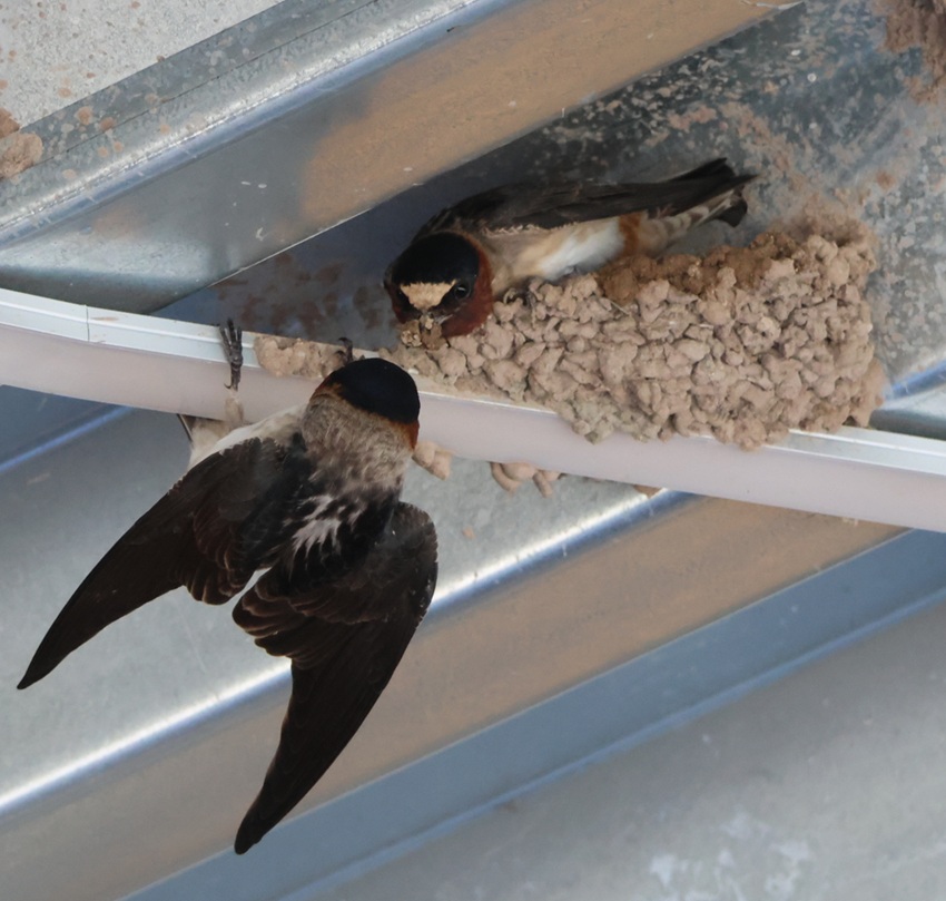
These are cliff swallows (Petrochelidon pyrrhonota) working together to build their mud nest under the roof of the refuge’s visitor center. Nancy and I estimated that there were several hundred of these swallows flitting about the visitor center and constructing their nests for the spring. These birds eat all kinds of flying insects and they are themselves incredibly skilled aerialists; I took about 50 pictures of swallows in flight at Valle de Oro and none of them turned out well because the birds were flying and turning so quickly. A staff person told Nancy that swallows lived in the huge dairy barn that used to be at the refuge, and they’ve adapted to using the new visitor center for nesting.

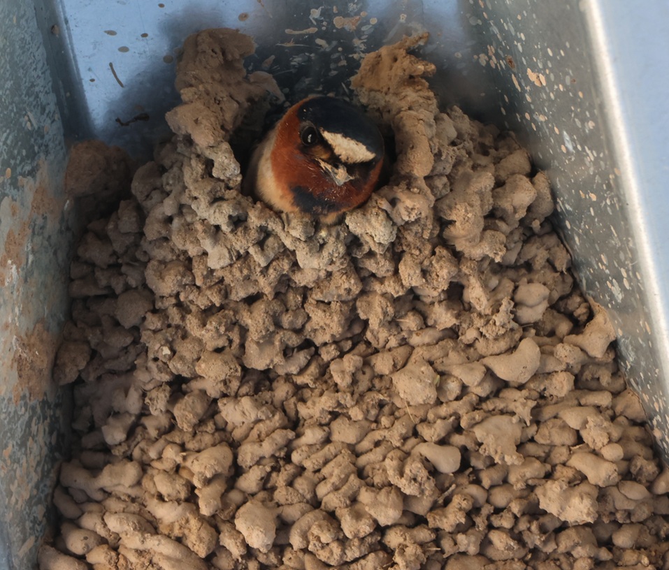
This nest appears to be nearly complete. Each nest is built from 900 to 1,200 mud pellets, with walls that are about 1/2-inch thick. A cliff swallow clutch can include between one and six eggs, and a female swallow may lay one or two clutches during the breeding season. Cliff swallows nest near bodies of water, which provide mud for nests as well as insect habitat. Most cliff swallow colonies contain between 200 and 1,000 nests, although there’s a colony in Nebraska with 3,700 nests. It strains the mind to think about how many flying insects are needed to feed all of those birds every day.
Here’s another western meadowlark that was perched about 50 yards from the refuge’s parking lot, with a link to an audio file of a western meadowlark’s call:

Whenever I hear that wonderful call, I’m reminded of meadowlarks that I used to listen to at the Denver-area office of one of my previous jobs. The parcel adjacent to the office was less than an acre but still unbroken prairieland, and it attracted quite a lot of wildlife including western meadowlarks. I enjoyed listening to them in the spring and summer months from the parking lot of my office, until construction began on that lot and it became another parking lot and commercial building. I remember being frustrated at the meadowlarks losing their habitat, and I also remember later realizing that the parking lot and building of my office was once wildlife habitat as well.

That’s the primary reason that the National Wildlife Refuge System exists: to protect wildlife habitats from development, or, in the case of Valle de Oro National Wildlife Refuge, to return commercially developed properties back into their native habitats. The Tiwa culture, the original inhabitants of this area in what is now central New Mexico, continue to play a major role in how Valle de Oro National Wildlife Refuge is managed and protected. I’m happy that’s the case.

Porcelain Basin at Yellowstone National Park

Norris Geyser Basin
September 12, 2025

Finding a parking spot for our Ford F-350 pickup, the 22-feet-long and six-wheeled towing unit of The Goddard, is sometimes a challenge. We usually just park on the outskirts of businesses’ parking lots because, unless the parking spots are oversized, we sometimes take up more than one space. When visiting Yellowstone National Park in September, we realized that we needed to get early starts in order to find spaces in the park’s parking lots: we arrived after Labor Day and park rangers assured us that visitation had noticeably dropped, but parking spaces were still at a premium beginning in the late morning hours, So it was when we visited Norris Geyser Basin, located in Yellowstone’s northwest quadrant: we arrived at about 8:30 AM on September 12 and happily found a parking space. It was already getting pretty chilly in mid-September: high temperatures in the basin that week were in the mid-60s Fahrenheit (about 18 degrees Celsius) and pre-dawn low temperatures were in the low to mid-30s Fahrenheit (about 0 degrees Celsius).

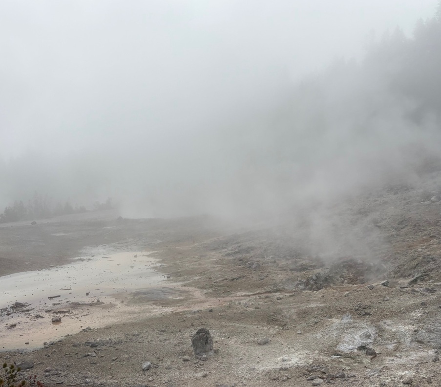
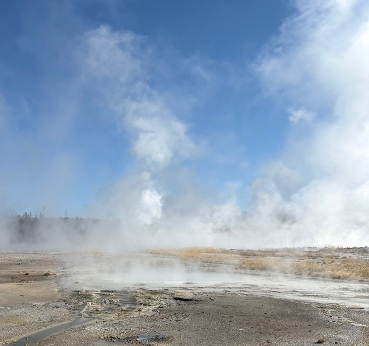
Those cold air temperatures combined with the hot steam rising from abundant geothermal features to create an otherworldly effect; it was extremely foggy, which made it difficult to discern any of the geysers, hot springs, and other features. The day soon warmed up, however, and the features revealed themselves. There are two different loop walks around Norris Geyser Basin: the longer and more forested Back Basin, which we visited later the same day (see that posting for an explanation of the different types of hydrothermal features, which I won’t repeat here), and Porcelain Basin. Here’s a look at some of what we saw in Porcelain Basin, once the air cleared a bit.

Those are some impressively large logs. This is the north-facing side of the Norris Geyser Basin Museum, designed by architect Herbert Maier (1893-1969) and built between 1929 and 1930. The museum, at 7,560 feet (2,304 meters) in elevation, was our first stop at Norris while we waited for the fog to dissipate. Maier also designed three other buildings in Yellowstone National Park: still-standing museums at Madison and Fishing Bridge, and the Old Faithful Museum of Geothermal Activity. Together, the four structures, built in an architectural style known as “National Park Service Rustic” that attempted to connect manmade buildings with the natural environments in which they were constructed, interpreted the geologic features on the Grand Loop road. Unfortunately, the museum at Old Faithful was demolished in 1971 to accommodate a new visitor center; that structure was itself demolished to make way for the current visitor center that opened in 2010. Maier also designed still-standing buildings in Yosemite National Park in California and Grand Canyon National Park in Arizona, as well as a number of structures in state parks in Texas.

This picture, I think, really captures the extraordinary beauty and kaleidoscopic color of Yellowstone National Park. (Not really: it captures the foggy conditions at Porcelain Basin for the first hour or so after our arrival.) This hillside is venting sulfuric acid, gas, and steam, and the colder temperatures on the morning of our visit made the venting look quite pronounced. Norris Geyser Basin is the hottest area in Yellowstone National Park, in which one only needs to dig four miles downward to find magma – rock that’s so hot that it has become liquified (one wouldn’t necessarily want to do that, though). The average surface temperature in the basin is 280.4 degrees F (138 degrees C), and a probe sent 1,086 feet (331 meters) under the ground’s surface registered a temperature of 464 degrees F (240 degrees C). A vent from which gases and steam escape is called a fumarole (from the French fumerolle, which is a domed vented structure built over a stove to allow steam and smoke to escape); a fumarole that vents sulfuric gases (like these in the photo) is called a solfatara, while a fumarole that vents carbon dioxide gases is called a mofetta. A muffuletta is a delicious Italian sandwich popularized in New Orleans, but that’s not important right now.

These pools, collectively called Porcelain Springs, give their name to the basin. They’re supposedly very pretty when the sun is shining on them, but I guess we’ll never find out for sure. The white mineral surrounding the bodies of water is called siliceous sinter, also known as geyserite. The silica is brought to the ground surface by the hot water in the pools, and accumulates very slowly – about an inch per century. Relatively new sinter is white; as it ages it turns to a darker gray color. The hydrothermal features in the greater Norris Basin, including both Back Bay and Porcelain basins, contain the highest level of silica in Yellowstone National Park – it’s what contributes the white milkiness (some might say porcelain-like) attribute to these bodies of water. Other minerals, like iron, arsenic, and sulfur, are all abundant as well. The latter contributes a distinct aroma to walks around these basins.

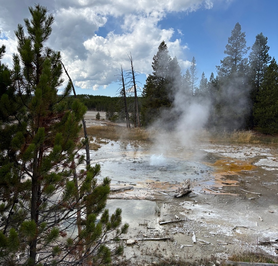
This photo, too, is indicative of what we saw while waiting for the fog to go away. As you can see, Porcelain Basin is not a terribly inviting place if the sun isn’t shining. These trees, interestingly, found the conditions in the soil conducive to germinate, grow, and mature into tall pines; the soil conditions later changed because of geothermal activity in Porcelain Basin and made the ground inhospitable to many lifeforms. Most of Norris Geyser Basin is walkable only on boardwalks like this one: the ground is too fragile (and, remember, it’s nearly 300 degrees) for visitors to walk on directly.

I took this photo from about the same position as the previous one (the boardwalk is just to the right side of the image), but looking slightly to the left and about half an hour later. You can see the sun was starting to emerge but steam is still rising from Nuphar Lake, which is itself not a geothermally heated body of water – it’s just plain old steam evaporating as the air temperature rises. Nuphar Lake (nuphar is a genus of flowering aquatic plants) has an interesting recent story, however. In 2021 and 2022, the lake’s water level rose by several feet (about one meter). Apparently, a geothermal feature near the lake began sending silica-laden water into the lake rather than into Porcelain Basin, which turned the lake’s water cloudy-white. The water level rose so dramatically that Nuphar Lake threatened to overflow its banks and into Porcelain Basin (which would have been pretty bad, because there are a lot of really pretty features there). By the end of the summer of 2024, though, the water level receded to its previous level and the color of the water returned to its normal clear green. Geologists found that an earthquake that occurred in April 2024 near the lake created a 10-foot-wide (about 3 meters) crater and caused water to stop flowing from the hydrothermal features. The dead trees in the previous photo, and those in the foreground of this photo, were killed by the silica-rich hydrothermal water that had been flowing into Nuphar Lake. That’s one big takeaway from our visit to Yellowstone National Park: nothing’s ever the same, and you can’t count on anything being there on a subsequent visit.

Well, well, well … look what decided to finally show up: the sun. This is the same Porcelain Springs body of water that’s in the upper-left corner of the image three photos up. A sunny day does make all the difference – they are very pretty after all. Like porcelain, almost.

The steam in Porcelain Basin, made more prominent because of the morning’s cold temperatures, was finally starting to dissipate so that we could see what else the basin had to offer. The sun was already pretty high up in the sky by that point, but it made for an interesting look. No retinas were damaged in the taking of this photo; the steam was a lot denser than it looks in the image.

This is Hurricane Vent, which once was a fumarole but has increased in size to include more water action as well as a small waterfall on its side. It was pretty noisy, and interesting to watch.

I took this photo just a few steps down the boardwalk from Hurricane Vent. This is looking to the southwest and at Ledge Geyser, which, while it rarely actually erupts, was certainly impressively active and loudly spouting steam from several of its vents during our time in Porcelain Basin. When Ledge does erupt, the geyser sends water more than 80 feet (24 meters) into the air. The Norris Geyser Basin Museum is on the other side of Ledge Geyser and up a hillside in this photo.

Here we’re looking northeast from the Porcelain Basin boardwalk and at Constant Geyser. When it erupts, Constant’s spouts of water can reach 20-30 feet (6-9 m) into the air, but last only about 10 seconds. The geyser can go 20 minutes or several hours between eruptions.

A few steps down the boardwalk, Whirligig Geyser (on the right) has eruptions that can be heard throughout Porcelain Basin. That green-hued stream on the left is the East Fork of Tantalus Creek.

Here’s a closer look at the East Fork of Tantalus Creek. In Greek mythology, Tantalus was one of the (many, many, many) sons of Zeus who, for whichever transgression(s) you might choose to believe, was sentenced to stand in a pool of water under a fruit tree. The fruit was forever just outside his grasp, and, when he bent to get a drink, the water below him always receded. Anyhow, the beautiful green color of this creek comes from the thermophiles, or heat-loving microorganisms, that live in the water, in particular Cyanidioschyzon (I did not, despite how much I would have liked to, make that word up). It’s a genus of algae that thrives in water that’s 100-126 degrees F (38-52 degrees C). The steam from Whirligig Geyser is obscuring them in this photo, but there’s also a population of red-colored thermophiles that is thriving in hotter waters (122-160 degrees F, 50-60 degrees C) closer to Whirligig’s opening. The red coloration comes from the iron oxide that is in the geyser’s outflow. You’ll recall from high-school biology and chemistry classes that the pH scale is used to measure the concentration of hydrogen ions in a chemical. The scale goes from 1 (most acidic) to 14 (most alkaline), with 7 in the middle at neutral. Some of the water features in Norris Geyser Basin have a pH value below 2; they’re nearly as acidic as vinegar. It takes a tough little organism to live in that hot, acidic environment.

This body of water, situated near the end of the Porcelain Basin loop, is Crackling Lake, named for the popping sounds made by geysers seen on its shoreline on the left.

Here’s a last look at Ledge Geyser. This photo was taken from the other side of the plume of steam from where I took the previous photo of Ledge (note the other folks on the boardwalk looking at Constant, Whirligig, and other geysers to the left-center of the photo). Even though it never erupted, Ledge Geyser was a most impressive hydrothermal feature that made it hard to forget that molten rock was just four miles below our feet.

After a brief respite in the parking lot (and our prime parking spot) for lunch, Nancy and I enjoyed the features of Back Basin. We saw a lot of hydrothermal features that day – fortunately the fog over Porcelain Basin lifted about an hour after our arrival so that we could see them – and my guess is that the next time we visit, we’ll see a difference in a national park in which nothing is ever truly the same.

Works Consulted

  • Lynne, Bridget Y. “The Geothermal Guide to Yellowstone National Park.” 2017.
  • National Park Service. “Norris Geyser Basin Trail Guide.” March 2024.
  • National Park Service interpretive signage at Norris Geyser Basin Museum and at features throughout Porcelain Basin.
  • Wikipedia, accessed October 2025. If you use Wikipedia, please support it.

Back Basin at Yellowstone National Park

Norris Geyser Basin
September 12, 2025

Norris Geyser Basin, located in the northwest quadrant of Yellowstone National Park, is one of the most active hydrothermal regions in the park and contains rare types of geysers within a geologically active earthquake area. The basin is located near the intersection of three major ground faults, helping to create the conditions for Norris’s significant geothermal activity. It’s outside the huge Yellowstone Caldera, the basin that remains after a titanic volcanic eruption 631,000 years ago, but within another 2.1-million-year-old caldera.

Nancy and I spent nearly all of Friday, Sept. 12, 2025, at Norris Geyser Basin. Named after Philetus W. Norris, the second superintendent of Yellowstone National Park, the geyser basin has two decidedly different trails: a short 3/4-mile (1.2 km) loop through the Porcelain Basin, and a longer 1.5-mile (2.4 km) loop with stops at geothermal features in the Back Basin. Both geyser basins are at an elevation of about 7,600 feet (2,316 m). Both trails involve the use of many boardwalks to keep visitors from walking too close to the heated features, and the ground is very thin in many spots and bad things would happen if someone broke through (and bad things do happen when someone decides to ignore the rules). I’ll write a posting detailing the Porcelain Basin later; for now, here are some of the sights to see and smell at Norris’s Back Basin, which includes the world’s tallest active geyser.

Before we get started though, let’s review hydrothermal features. Yellowstone National Park’s hydrothermal features are created by magma, which is partially molten rock, remarkably close to the park’s surface. Water, either from snowmelt or rain, percolates downward through faults and fractures in the earth’s surface and then, after making contact with the hot rock formation, rises back toward the surface and collects in open channels that serve as the hydrothermal features’ water supplies.

Geysers, perhaps the most familiar type of hydrothermal feature, form if the channel has a constriction of some type that pressurizes the water. Temperatures in the superheated and pressurized water below the constriction create steadily amounts of steam, which is eventually pushed through the constriction and an instantaneous drop in water pressure below the steam creates an eruption. These events can be fairly predictable, as in the case of Yellowstone’s Old Faithful, or irregular, with intervals between eruptions lasting unpredictable numbers of days, weeks, or even longer.

If a channel doesn’t have a pressurizing constriction, a hot spring is formed as superheated water comes to the earth’s surface, cools somewhat, and is replaced by hotter water beneath it.

The hottest hydrothermal features in Yellowstone National Park, fumaroles, are steam vents in which channel systems have little access to water, and whatever does reach the surface is immediately converted to steam with a temperature greater than that of water’s boiling point (212 degrees F, or 100 degrees C, at sea level).

Finally, mudpots are created when rock around a hydrothermal feature is converted, by acid, into clay. When it mixes with water, the clay forms mud of different colors and viscosities. Gases in the feature bubble up through the mud to make interesting sights, sounds, and smells.

All hydrothermal features are susceptible to changing environmental conditions. If access to water is changed, or the fissures around a feature are altered because of seismic activity, the feature’s activity could change dramatically or even cease altogether. Many geysers, for instance, that were active in years past are now quiet.

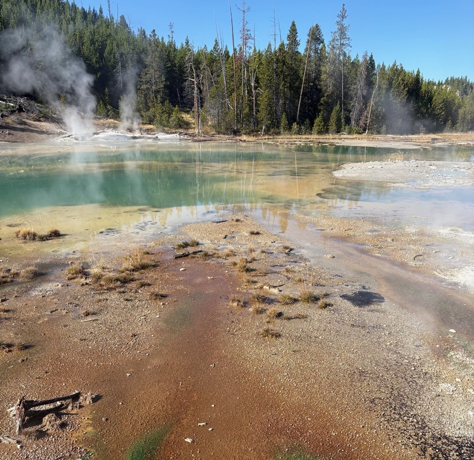
The first stop on the Back Basin Loop is this very pretty 27-foot-deep pool, Emerald Spring. The color of a particular hot spring can help determine what minerals that spring contains. Water in a relatively mineral-free clear blue spring, for instance, absorbs all of the colors of sunlight except for blue. Emerald Spring contains significant deposits of the mineral sulfur, the yellow color of which combines with the reflected blue sunlight to create this beautiful shade of green. The temperature of the water in this spring is close to the boiling point, ensuring that only the most heat-tolerant microorganisms, or thermophiles, can survive in this environment. There’s plenty of sulfur in this spring, which is used by some thermophiles as a source of energy. The byproducts from the sulfur’s usage in turn are used by other thermophiles, resulting in a kind of recycling process that creates something like thermophile interdependence.

Next up is the world’s tallest active hydrothermal feature, Steamboat Geyser. Although there was a lot of steam evident, Steamboat Geyser on the day of our visit was relatively quiet with just a few intermittent spurts of water measuring a few feet high. When it goes, though, Steamboat really goes: it is capable of shooting steam and water up to 300 feet (91 m) into the air. That’s the distance of a football field. Prior to 1904, Steamboat was not the tallest geyser in the world. That honor belonged to a geothermal feature in New Zealand, Waimangu Geyser, which shot water a mind-blowing 1,600 feet (488 m) into the air. A landslide changed the water table around Waimangu, however, and it hasn’t erupted since.

Here’s the thing about Steamboat that’s really wacky: its eruptions are extraordinarily erratic. In the nearly 30 years between 1990 and 2017, Steamboat erupted 12 times (including one interval between eruptions that lasted almost 9 years). Between March 15, 2018, and May 7, 2023, a little over five years, the geyser erupted 165 times. We visited in mid-September 2025, and Steamboat’s last major eruption had occurred on April 14 – five months earlier. Before then, it erupted on Feb. 2, 2025, a little over two months earlier. In all of 2024, Steamboat erupted six times. Nature is chaotic sometimes, and it’s beautiful. Note the huge desolated treeless area in the photo above. The geyser’s eruptions, helped by prevailing southerly winds, caused that destruction.

Cistern Spring is located downhill from Steamboat Geyser – I didn’t measure the elevation change, but it’s at least 50 feet lower, and the boardwalk trail has a couple of switchbacks. However, Cistern Spring is connected underground to Steamboat because it empties completely whenever the larger geyser erupts. The brown, green, and orange colors in Cistern Spring are created by different species of thermophiles. The dead trees around the spring were killed by the silica in Cistern Spring’s water: conditions around the spring were once healthy enough for the trees to germinate, grow, and mature, but then the conditions changed. We saw that a lot all over Yellowstone National Park: big areas of trees that had been killed by changing hydrothermal features.

This feature has one of the best names in the Back Basin. It’s Black Pit Spring, and it started off about half a century ago as a group of steam vents. Water now continuously bubbles with very small eruptions at its surface.

Here’s a closeup, using a telephoto lens, of the little eruptions from Black Pit Spring. It’s a pretty mesmerizing hydrothermal feature, with a great variety of colors (not so much black, though).

This is Echinus (pr. e-KI-nus) Geyser, perhaps my favorite feature in the basin. It is named for its mineral deposits, which apparently look the spins of sea urchins (neither Nancy nor I are overly familiar with echinoderms like sea urchins, but we didn’t see anything that resembled sea urchin spines). The red color is due to high concentrations of iron oxide (rust) in the feature. Echinus’s eruptions, which can reach 60 feet in the air, are unpredictable and are now months and even years apart. From 1878 to 1948, the geyser rarely erupted but then moved to periods of relative high activity alternating with dormancy. Prior to 1998, it was on an eruption schedule of about every half-hour to 90 minutes. The scientists believe that something happened underground in 1998 to affect the geyser’s water source. For now, it’s a fairly large and very pretty pool of water (see the guy emerging from the trees on the boardwalk just right of center for scale).
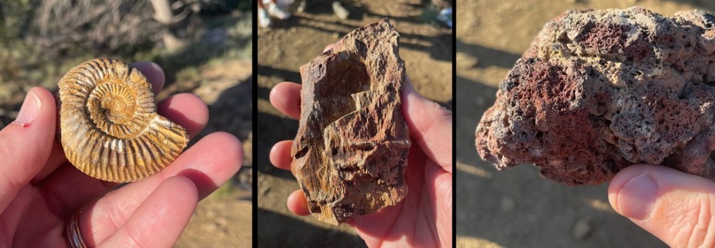
This photo was taken on the other side of the geyser from where the previous photo was taken, i.e. just to the right of the guy on the boardwalk in the photo above. Echinus Geyser is a beautifully complex hydrothermal feature, even if we can’t make out the sea-urchin-ish spines.

Here’s one of the reasons why Echinus Geyser appeals to me so much: these are terrace formations on the geyser’s southwest side where water leaves the geyser. I took this photo at about the same spot as the photo above, but used my telephoto lens again. These terrace mats are formed by unthinkably large numbers of a microorganism called Archaea (pr. aar-KEE-ah), which is a an immense domain of life that precedes kingdoms (you remember, from high-school biology, the memory aid “Kings Play Chess On Fine Green Sand,” or Kingdom, Phylum, Class, Order, Family, Genus, Species; domain is a step above kingdom). Water coming from the geyser is 176.5 degrees F (80.3 degrees C), and has a pH of 3.3 to 3.6 – it’s nearly as acidic as vinegar. At this point in the terracing, the temperature drops to between 140 and 160 degrees F (60 to 71 degrees C). Archaea absolutely love this hot and acidic water, and survive on the energy produced by iron oxidizing in the geyser’s water then bind together to build these ridges, pools, and ripples. Archaea are very common in nature: different types are found everywhere on the planet, including other features in Yellowstone National Park, and your gut, mouth, and skin are covered in them right now (not the same ones in this picture; remember that Archaea covers a lot of different species, let alone all of the other Kings Playing Chess). It’s extremely likely that when the scientists do find irrefutable evidence of extraterrestrial life, it will be in the form of Archaea or something close to it.
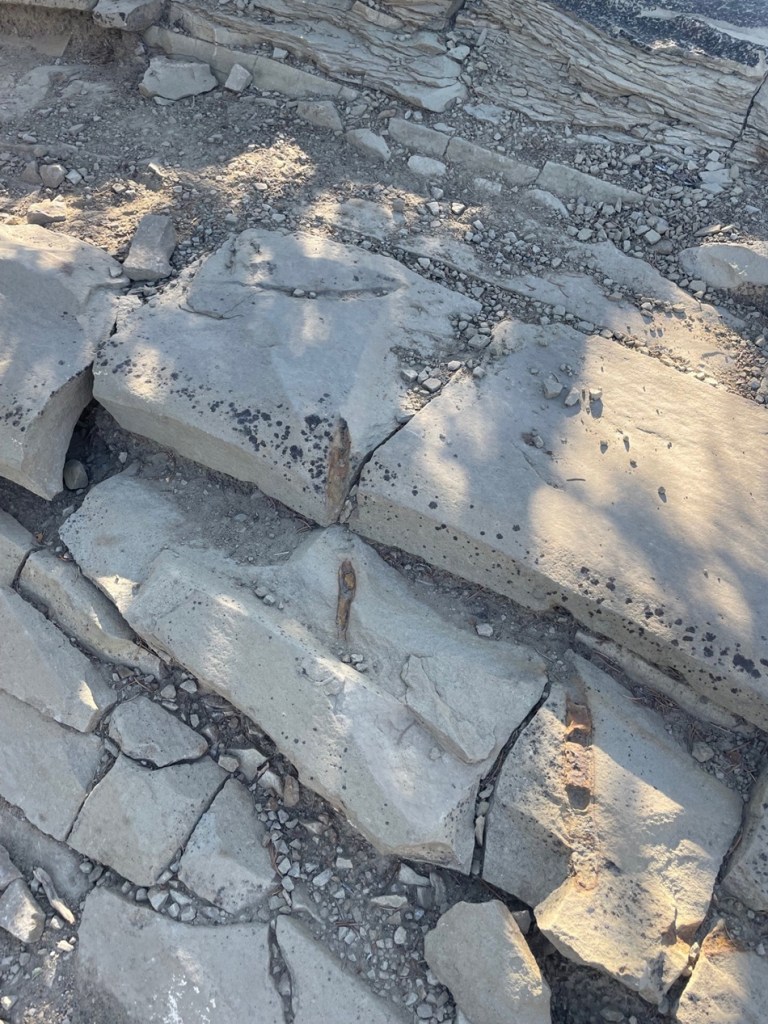
This is a view a little further down the boardwalk from Echinus Geyser. That small river of water is flowing northwesterly from the geyser – it’s a pretty desolate landscape in the river bottom, but remember that the river has a pH nearly equal to that of vinegar. Notice also the steam rising from the ground where the river meets the trees in upper left; as the scientists say, this is a geothermally active area, and that is evidence of yet another geothermal feature.

This is Porkchop Geyser, so named because of its shape when viewed from above and which only intermittently erupted until 1985 when it started spouting on a continuous basis. Those eruptions wasn’t enough to keep the geyser’s constriction from building up tremendous pressure and four years later, on Sept. 5, 1989, this feature exploded with a violence sufficient to throw large rocks more than 200 feet (61m). Fortunately, the tourists present for this surprise event weren’t injured. Porkchop’s vent hole at times has been the diameter of a garden hose; after the explosion, it’s about 7 feet in diameter. After that event, Porkchop became a gently bubbling hot spring with only occasional – and unpredictable – geyser eruptions.

Even if it didn’t erupt while we were there, Veteran Geyser was a lot of fun to listen to. The area in shadow in the lower right corner of the picture is a vent through which Veteran exhaled with what sounded like someone in severe respiratory distress. A couple with whom I’d briefly spoken at Steamboat was here admiring Veteran as well, and, realizing that we were nearing the end of the Back Basin loop, the woman asked what our favorite hydrothermal feature was. I quickly answered with Echinus Geyser, and asked what her favorite was. She said it was Black Pit Spring, but mostly because of the name. I couldn’t disagree with her. In a basin filled with features named Green Dragon Spring, Puff ‘n Stuff Geyser, and Black Hermit Caldron, Black Pit Spring does still manage to stand out.

At the time when Yellowstone’s visitors toured via stagecoaches, Minute Geyser erupted every 60 seconds to heights of 40 to 50 feet (12-15 meters). Inexplicably, many of those tourists tossed rocks into one of the geyser’s vents and eventually plugged it. While it continuously spouts water about 3 feet (0.9 meter) now, it’s unknown whether the feature will ever fully erupt again. Signs warning tourists to not throw rocks, coins, or other objects into park’s hydrothermal features were all over Yellowstone. I just can’t wrap my head around why someone would want to do that in the first place.

The Back Basin loop trail ends with a short hike up a hillside, resulting in this magnificent view of Norris’s other geyser area, the Porcelain Basin. I’ve got pictures of the features within Porcelain Basin as well, and will post those in the near future.

There are about 25 named features within Back Basin, so this was a look at less than half of what’s there. Walking around any of Yellowstone National Park’s hydrothermal areas gets you really close to all kinds of aspects of our natural world, and it’s easy to think that it’s always looked the way it appears today. But conditions underground, like earthquakes, heat changes, mineral buildup, and more, ensure that these features are anything but timeless: a geyser can become a hot spring (and vice versa), for instance, because of subtle and usually unseen geologic changes.

It was a fun day at Norris’s Back Basin, and one that Nancy and I will appreciate for a long time – especially because the next time we go, it may be significantly different.

Works Consulted

  • Lynne, Bridget Y. “The Geothermal Guide to Yellowstone National Park.” 2017.
  • National Park Service. “Norris Geyser Basin Trail Guide.” March 2024.
  • National Park Service interpretive signage at features throughout Back Basin.
  • Wikipedia, articles on Archaea, Echinus Geyser, and Steamboat Geyser. Accessed September 2025. If you use Wikipedia, please support it.

Homol’ovi I

Homolovi State Park, near Winslow, Arizona
April 16, 2025

We’re camping for two weeks in Homolovi State Park, just a couple miles east of the town of Winslow, Arizona (pop. 9,005; perhaps you’ve heard of it – one of its street corners is mentioned in the Eagles’ first major hit from 1972, “Take It Easy”). This is our third time staying here in three years – we really enjoy it. After spending five months wintering in Las Vegas, Nevada, and then a couple of campgrounds on Interstate 40 in Arizona, we’re appreciating the quiet environment and dark skies of this state park (not that we didn’t have a good time in Las Vegas; in fact, we’ve reservations to be back there beginning this November).

The main feature of this state park is a cluster of four major ancient Native American villages, several miles apart and all built and occupied around the years 1290-1400. The villages were then abandoned, but it’s generally understood that the people who lived here eventually became what is now the Hopi nation – one of the tribe’s reservations is about 60 miles north of present-day Homolovi State Park. The four villages are designated Homol’ovi I-IV; the name of the state park doesn’t include the apostrophe of the village names. “Homol’ovi,” in Hopi, translates to “place of the little hills,” and the Hopi also refer to the city of Winslow as “Homol’ovi.”

The Hopi call the people who lived here – most likely their ancestors – the Hisatsinom, which means “the people of long ago.” During the period in which the Hisatsinom lived in this region, they built and occupied four or five large villages – some comprising hundreds of rooms – using rocks gathered from the ground.

The Little Colorado River, a watercourse that drains the Painted Desert area of northeastern Arizona, flows through Homolovi State Park. I took this photo while Nancy and I were driving to Winslow; the perspective is looking north from a bridge on the former U.S. Route 66 (and now Arizona State Highway 87). The trucks and trailers just on this side of the horizon are on Interstate 40. The Little Colorado River’s headwaters are in the mid-eastern region of Arizona, very near the state’s border with New Mexico. It then flows almost 340 miles in a northwestern direction until it empties into the Colorado River in the Grand Canyon. The river flows from its headwaters all the way to the Grand Canyon only during periods of flash flooding or heavy snowmelt; much of the year it’s a braided and puddled wash. I took this photo the day after the area got some appreciable rain and snow, and the water level rose only marginally. The occasional flash flooding of the Little Colorado River, which swept away crops and structures, is probably why the Homol’ovi sites were abandoned in favor of the area further to the north and which the Hopi call home today.

This is the site of a major native American village, known now as Homol’ovi I, that was last occupied about 600 years ago. At its peak, it contained about 1,100 different rooms constructed of rocks. Some of the rooms included three stories. Over the ensuing six centuries, a lot has happened to destroy these unoccupied villages. Dependable northern Arizona winds have covered the village with dirt and sand, but some structures, such as the one on the mound at the right, can still be discerned. Many of the rocks in the structures were taken by members of a nearby Mormon community in the late 1800s for use in their own buildings, and vandals have also destroyed the buildings and looted the pottery.

Take a look at the tall plants on the horizon at far left: directly to the right of them, you’ll see some white splotches (not the clouds, which are further to the right; the smaller white splotches of which I write are immediately to the right of the tall plants). Those are the San Francisco Peaks, still snow-covered in mid-April. The town of Flagstaff, Arizona, is at their feet. Those mountains are about 65 miles west of Homolovi State Park.

I took a picture of this image, an artist’s depiction of what Homol’ovi I looked like at its peak, at an information kiosk near the site of the former village. That’s the Little Colorado River in top right. The original image gives credit to Douglas Gann of the Center for Desert Archaeology.

From about 1290 to 1360, it’s believed that Homol’ovi I grew from a village of 200 rooms to more than 700. Around the year 1360, the village now known as Homol’ovi II was established about 3 miles, or 5 kilometers, north of Homol’ovi I; that second village quickly became the biggest one in the cluster at 1,200 rooms. Homol’ovi I, however, benefited from the second village’s success, and grew to a maximum of 1,100 rooms.

This photograph was taken from the top of the hill shown in the previous photo, still looking to the northwest. The rocks in a line are the former wall of a room. The trees near the horizon are on the east bank of the Little Colorado River; it was that river’s occasional flash flooding that likely led to the abandonment of Homol’ovi I and the other villages 600 years ago.

This is a small grouping of pottery shards and what appears to be a hand-shaped rock, taken from the ground at Homol’ovi I and placed on a larger rock. The pieces of pottery are roughly the size of an American half-dollar. There are thousands of shards like these at the site, and most of them are on larger rocks like this. Archeologists and conservationists prefer that people don’t do this; instead, simply leave the shards on the ground.

This is the largest exposed wall still standing at Homol’ovi I, and it’s been almost entirely rebuilt by archeologists. Note the small collections of pottery shards on some of the rocks at left: don’t do that.

THIS IS A TALES OF THE GODDARD LIZARD ALERT. This little guy (and he is a guy, and I’ll tell you why I know shortly) caught my eye as he scampered across the rocks and sand of Homol’ovi I. He is a side-blotched lizard, a genus (Uta) of which there are now seven species, and he and I were to have kind of a neat interaction.

This photo of my new reptile pal shows why the genus is called side-blotched lizard – observe the dark mark (or, in scientific terminology, “blotch”) on its side just behind its front leg. The turquoise-blue dots on the back are also a defining characteristic of the genus. These lizards grow to a length of about six inches, including the tail. Their diet includes insects, spiders, and other arthropods such as the occasional scorpion. They are themselves predated upon by larger lizards and roadrunners.

In an attempt to give the reptile some space, I continued walking down the path through Homol’ovi I – but the beast pursued me. Observe the very pretty light-blue dots on its back. I was about six feet from the lizard when I took this photo (using a 400mm telephoto lens).

Here’s a cropped version of the previous photo. Behold those beautiful blue dots as well as some detail of its fearsome front claws. After I took the photo, the lizard continued to approach me: in fact, it got to about six inches from my left foot – and then it scampered away. Turns out, that’s a common behavioral trait of male side-blotched lizards. The scientists don’t know if the behavior is intended to scare away possible intruders from its mate, or to defend its territory. At any rate, I got the hint and moved along (even though my course on the path took me in the same general direction of the lizard, who at that point was many yards away). I later described my interaction with the side-blotched lizard to Nancy, who did not at all appreciate when I poked her under her armpit to show her where the blotch on the lizard’s side was. We also shared the same belief that she would have absolutely and completely freaked out if the lizard had gotten to within six inches of her left foot.

More wildlife: I always like to include some bird photos in these postings, so here are a couple of images I took in our campground at Homolovi State Park. This is a black-throated sparrow (Amphispiza bilineata), a species found in the southwestern United States and much of Mexico. They are absolutely beautiful little birds. I’ve seen them only here at Homolovi State Park and at Tuzigoot National Monument, further west in Arizona.

This is a loggerhead shrike (Lanius ludovicianus), on a tree just a few feet from the Goddard’s campsite. I remember reading about shrikes when I was young, but I didn’t see one in the wild until a couple of years ago at McDowell Mountain Regional Park east of Phoenix, Arizona. I also saw some over this past winter at Clark County Wetlands Park, very close to the campground where we spent the winter near Las Vegas. Loggerhead shrikes are found nearly all over the United States.

We’re planning to join a ranger-led tour of Homol’ovi II, which has been partially excavated and reconstructed, on Saturday, April 26. I’ll write and post photographs from that experience afterwards. We were on the same tour a couple of years ago, but, because of our travels and opportunities to see ancient Native American sites in the southwestern United States since then, we have a better perspective of what we’ll see.

Chimney Rock National Monument

September 28, 2024 – Near Pagosa Springs, Colorado

At the entrance to Chimney Rock National Monument, one can see Chimney Rock (center horizon), Companion Rock (to the left of Chimney Rock), and the mesa on which an ancient Puebloan great house still stands (at far left).

The scientific pursuits of geology, archeology, and astronomy combine in a number of interesting ways at Chimney Rock National Monument, located about 20 miles of Pagosa Springs in southwestern Colorado. In late September 2024, the Goddard was parked for a couple of weeks in Pagosa Springs, allowing us to enjoy the spectacular fall colors of aspen trees as well as a visit to Chimney Rock National Monument. We joined a geology-focused tour of the monument led by a volunteer guide, a former geologist in the oil and gas industry. In addition to learning about the rock features of the monument, we also learned about the history of the human habitation of Chimney Rock and visited the highest-in-elevation ancient Pueblo in the American Southwest, the Great House.

I took this photo from the road entrance to Chimney Rock National Monument using a telephoto lens. For perspective, Chimney Rock on the right rises more than 300 feet above the dark gray shale layer below it.

Between the years 925 and 1125, more than 2,000 Pueblo Native Americans lived in the Chimney Rock region and, although no more than about 250 people called it home at one time, they made it a substantial settlement for two centuries. The inhabitants built a number of stone and timber structures that are still standing today, and they traded goods with other Pueblo communities up to 150 miles away. Today, archaeologists know of 200 ancient structures collected within eight distinct villages at Chimney Rock.

Initial archeological investigations began in the 1920s by J.A. Jeançon, a Smithsonian Institution-trained archeologist working on behalf of the Colorado Historical Society, and his assistant, Frank Roberts; they and their crew surveyed and mapped dozens of structures and found thousands of artifacts.

Today, the U.S. Forest Service, which manages Chimney Rock National Monument, is leaving many archeological sites undisturbed out of respect for existing Puebloan and other Native American cultures, and with the understanding that less-invasive archeological techniques may be developed in the future. More than two dozen Native American tribes have an affiliation with Chimney Rock.

The monument, surrounded by the Southern Ute Indian Reservation, is closed to the general public each year from September 30 to May 15. The closure allows Native Americans to access the site for private ceremonial purposes, and the Chimney Rock area is also a major thoroughfare for elk migration.

Geology! These three rocks, all of which were collected earlier at Chimney Rock by the volunteer geologist conducting our tour, tell a really interesting part of the story of the area. The ammonite fossil at far left shows that Chimney Rock, which today gets about 14 inches of precipitation annually, was once covered by an inland sea. Ammonites were incredibly diverse and numerous aquatic cephalopods (related to modern squid and octopi) that flourished for hundreds of millions of years until the Earth’s collision with an asteroid 65 million years ago. The petrified wood in the center indicates that large trees used to grow on shorelines left when the land rose and the sea receded. Finally, the basalt at right was ejected from an erupting volcano in the area. (Yes, I know the ammonite photo also demonstrates that I was, at the time, in gruesomely desperate need of my semi-annual mani-pedi.)

The true importance of Chimney Rock lies, of course, in its ties to ancient and current-day Native Americans. But from a geologic perspective, the story of Chimney Rock begins, seemingly as do so many on this website, with a great inland sea. One hundred million years ago, much of present-day North America was under a shallow but vast sea that connected the Gulf of Mexico to the Arctic Ocean. At its largest size, the Western Interior Seaway stretched from today’s Rocky Mountains in the west to the Appalachian range in the east. At its deepest points, it was only about 3,000 feet from the waves on top to the sea bottom – very shallow for a sea. The size of the sea varied widely over the course of its 34 million years of existence; it finally drained away for good about the time of the end of the Cretaceous Period, or 65 million years ago when dinosaurs ceased to rule the earth.

While it was relatively shallow, the Western Interior Seaway’s 3,000 feet of water depth carried a lot of compression capability. Clay at the bottom of the sea, as well as dead plants and animals, accumulated over the eons to build a 1,000-feet-thick layer of mud. That layer would solidify, over millions of years of water weight pressing upon it, into a dark gray layer of rock called Lewis Shale. When the western part of the American continent began to rise, the waters of the inland sea drained away to leave shorelines of sand and tidal flats. Dry periods alternated with years upon years of wetter conditions, leaving layers of coal and fossilized animal skeletons.

About 40 million years ago – 26 million years after an asteroid impact killed all of the non-flying dinosaurs as well as a goodly amount of other life on Earth – volcanoes began erupting in the Four Corners area of Colorado, Utah, New Mexico, and Arizona. This activity built the Colorado Plateau, a huge high-desert expanse of the southwestern United States covering 130,000 square miles of those four states, roughly centered in the Four Corners area.

The erosional forces of wind and water began to have their way with the soil covering today’s Companion Rock and Chimney Rock, and then glaciers from the last Ice Age of 4 million years ago carved deeply into the former mud of the inland seafloor, now compressed into shale. Finally, the glaciers melted and the resulting floodwaters exposed sandstone – formerly the beaches of the receding inland sea from tens of millions of years earlier but compressed into a rocky layer – and eroded away nearly all of that sandstone layer with the exception of Companion Rock and Chimney Rock. The scientists believe that the two sandstone features have been exposed for about 25,000 years, protected by what was probably the thickest and hardest layer of sand during the time of the Western Interior Seaway and is now a layer of sandstone more resistant to erosion than other rocks had been. However, they too, with the relentless work of water and wind, will gradually fall to the valley below.

This view, looking east on a hazy late-September morning, shows the dark-gray Lewis Shale layer below the light-brown Pictured Cliffs Sandstone layer, of which Companion Rock and Chimney Rock are the tallest remnants. This valley was carved by glaciers and the flooding of the melted glaciers as well as the Piedra River. To the immediate left of the two natural rock towers is the Great House, built by ancient Puebloans . The San Juan mountains, volcanic in origin, are on the far horizon.

This is the trail leading to the monument’s Great House, one of the square exterior corners of which can be seen at the top of the photo. This is the same trail that was used by the ancient Puebloans to make their way from the valley floor to the Great House. The trail is situated on a relatively thin ridge of sandstone. Everything brought to the Great House – building materials, foodstuffs, water – was carried by the ancient Puebloans, by hand, up this trail.

These sandstone rocks are on the trail to the monument’s Great House. Our geologist guide noted that the natural fracturing of the sandstone made selection and collection of the rocks much easier for the Puebloan builders of the structures in the monument. Note also the brownish markings in the rocks: they’re about 6-8 inches long, and are the fossilized burrows of a prehistoric crustacean that lived in the sand of the inland sea that once inundated much of North America. The animals dug these burrows into the existing shoreline sand, and the holes gradually filled with clay and mud containing iron to leave behind the brown fossils seen on the trail today.

Archeology! This south-facing exterior wall of the Great House has an interesting story. Most of the rocks comprising the Great House and other structures were replaced, in place, over the last century by archeologists and during a major project in the 1970s involving Native Americans. The structures had simply fallen victim to the forces of erosion over the course of 10 centuries of non-occupancy. However, the modern-day wooden shelf in the center of this photo is protecting part of a stone wall that was laid by Puebloan hands a thousand years ago and managed to stay intact. Note the different size and color of the rocks surrounding the original work.

The rock formations are still quite a good distance from the Great House; Chimney Rock itself is 315 feet tall. Scientific analysis of some of the wood beams still left at the Great House shows that construction began in the year AD 1076 and then expanded in AD 1093. Those particular years would prove to be significant in discovering why Great House was built where it was.

This picture was taken looking southwest from atop one of the Great House’s walls. Many of the rocks in the walls have been replaced over the years, but some parts of the walls feature the original masonry and stonework. It’s estimated that the Great House was built using up to six million stones, all of which were hand-selected, hand-shaped, and hand-carried to this site. All of these walls were once taller, and roofs covered the buildings. On the far horizon, in the center of the photo and between the left and right hillsides, lies New Mexico. Visitors from Chaco Canyon, 90 miles away, would approach the Chimney Rock villages through that low valley. Similarities between the architectural styles of the buildings at Chaco Canyon and Chimney Rock, as well as those of cultural artifacts, such as pottery designs, stone tools, and projectile points, demonstrate that the two communities shared many ideas over the two centuries of Chimney Rock’s existence. Similar artifacts show that the residents of Chimney Rock may have traded with still other Native Americans living up to 150 miles away.

Jeançon began his excavation of the Great House Pueblo in 1921. He noted that some of the walls were still 14 feet tall. The building contained at least 35 rooms and two kivas, the round structures believed to be the center of the ancient Puebloans’ spiritual and perhaps social lives. An archeologist has estimated that to build a structure of this size and complexity, in addition to the 6 million rocks, the builders would have needed 5,000 log beams, 25,000 tons of water, and 25,000 tons of dirt to make an adobe mortar. All of these materials would have had to have been carried up the steep trail by hand.

Considering all of the labor needed to build Great House and the many other structures, one is left with the question of why the residents stayed here for only two centuries. There are three prevailing hypotheses for the ancient Puebloans’ departure: it’s possible that the area was depleted of food and other resources; societal changes or perhaps warfare made it in the residents’ best interests to leave; or the community, representative of other Puebloan cultures of the time, simply decided that it was time to find a new home. Whatever the reason for their departure, it’s believed that the residents of Chimney Rock, along with many other ancient Puebloan communities, moved south into present-day New Mexico and Arizona; their descendants can be found today among the members of the Navajo, Hopi, Zuni, and other Native American tribes.

While at the Great House, I took a picture of Companion and Chimney rocks with my telephoto lens. The distance from the Great House to the rock formations makes them look smaller than they actually are; as I noted earlier, Chimney Rock, the structure furthest away, is taller than a football field is long. The top of Companion Rock is a nesting area for peregrine falcons. Because of their spiritual significance to Native Americans and to protect the birds’ nests, both rock formations are off-limits to hikers and rock climbers.

That covers some of the geology and archeology at Chimney Rock National Monument; let’s move on to the skies above. Nancy and I learned a new word the day we visited the monument: archeoastronomy. This vowel-heavy construction refers to the study of the ways in which ancient cultures studied the skies and how they used that information to guide many of their day-to-day and seasonal decisions, including when to plant crops and conduct spiritual ceremonies. Around the world, very old cultural sites, like Stonehenge in England and hundreds of temples in Egypt, show that ancient peoples were keenly aware of the movement of the sun, moon, planets, and stars.

Observing the skies and the objects contained in the vast expanse above also played a major role in the ancient Native Americans’ religious lives. In North America, evidence of the significance of celestial movement to Native American cultures can be found in many places, including at Chaco Canyon and at Chimney Rock.

The most significant alignment of celestial objects and Earth-bound structures at Chimney Rock is known as the Northern Major Lunar Standstill. (That was another term and concept new to Nancy and me, neither of whom are anywhere close to unfamiliar with astronomy, but I guess that’s a big reason that we’re doing this: each time Nancy and I leave the Goddard to visit a museum or national park, we ask each other, “Are you ready to do some more learnin’?”)

Many will be aware that the rising and setting of the sun appears to move across the horizon as the year progresses: on the day of the summer solstice it appears to rise and set in its northernmost latitude (and makes for the longest day of the year in the northern hemisphere), and then the sunrise and sunset appear to occur further south each day until the winter solstice, making for the shortest day of the year. It then appears to move north again to complete the second half of the solar cycle.

The moon has a similar cycle, appearing to rise at different locations from north to south like a pendulum over the course of a month. The Northern Major Lunar Standstill, or MLS, occurs on a recurring cycle of 18.6 years when that pendulum of the moon’s rise appears to stay in the same location on the horizon for a period lasting about 16 months.

Here’s the significance of the MLS to the manmade and natural stone structures at Chimney Rock: during the lunar standstill and when viewed from the Great House Pueblo, the moon appears to rise between Companion Rock and Chimney Rock. Archeoastronomers don’t know this for an absolute certainty, but it appears that the Great House was built where it was so that its ancient Puebloan residents could observe this event that occurs on a cycle of just under two decades. The years AD 1076 and 1093, when the structure was built and later expanded, were both years in which lunar standstills occurred. It’s quite possible that many ancient Puebloans from around the Four Corners region traveled to the Great House to view this powerful spectacle alongside the residents of Chimney Rock.

As it happens, in late 2024 the MLS was nearing the end of its cycle at Chimney Rock – our U.S. Forest Service geologist guide showed us pictures on his cellphone he’d taken of the moon rising between the two rocks just a few nights before our visit. We briefly lamented not being able to see the event ourselves, but the guide noted that very few people are allowed to be at the Great House at night. It’s of extraordinarily powerful spiritual significance to modern Puebloans, of course; it’s also incredibly dangerous to walk the trail to the Great House at night because of the trail’s position on a very thin ridge. The Forest Service and its academic partners in astronomy have a camera situated at the Great House, and the transmission showing the moon’s rise between Companion Rock and Chimney Rock is seen by many people down at the monument’s visitor center.

I’ve long had an affinity for this wildflower, desert paintbrush, so I was happy to see this specimen blooming just a few steps from the Great House.

Astronomy, again! While researching the information for this posting, I happened to notice that the Griffith Observatory, based in Los Angeles, was hosting a livestream of the moonrise from Chimney Rock on the evening of October 21, 2024. Nancy and I were very happy to watch this event from our living room in the Goddard as it was parked in Flagstaff, Arizona, three weeks after our visit to Chimney Rock National Monument. To sum up, we watched an astronomical observatory in southern California conduct a livestream of the moon rising between Companion Rock and Chimney Rock, 350 miles away from where it was happening in southwest Colorado while we were camping in northern Arizona. As I often say, we’re living in the future.

Jackson Flat Reservoir

Kanab, Utah – Late May & Early June 2023

I’ve been reading “Riders of the Purple Sage,” one of Zane Grey’s early books that helped shape the Western novel formula. Publishing the book in 1918, Grey (1872-1930) was inspired to write a Western story after reading Owen Wister’s “The Virginian” (1902). It would be the most popular of Grey’s 90 books (it’s estimated that he wrote 9 million words in his career). Later prolific western authors like Max Brand and Louis L’Amour were heavily influenced by Grey; L’Amour himself wrote 89 novels and 14 collections of short stories. “Riders of the Purple Sage” has been adapted for film five times: in 1918 and `1925 (both were silent movies), 1931, 1941, and a 1996 TV movie starring Ed Harris and Amy Madigan (who have been married to each other since 1983).

Although I’ve read “The Virginian” and lots of Louis L’Amour’s books, I’ve never read a Zane Grey novel (my only point of reference to Grey was knowing that Colonel Sherman Potter of the 4077th Mobile Army Surgical Hospital was a big fan). I’ve been struck how, in “Riders of the Purple Sage,” Grey deftly describes the canyons, mesas, and flatlands of southern Utah, the setting of the book. The characterization and dialog in the book are definitely of their time, but the story itself is pretty exciting and Grey was quite skilled at painting, in words, how the incredible scenery of the region appears.

Reading “Riders of the Purple Sage” reminded me of when we were in southern Utah and northern Arizona for an extended visit in 2023. We’d planned to stay in Fredonia, Arizona, for four weeks so that we could visit a couple of national parks and monuments in the region. Mechanical issues with The Goddard, our fifth-wheel trailer, extended our stay for an additional week. We were unable to lower the front jacks of our trailer, which meant that it had to stay hitched to the six-wheeled towing unit. A very competent RV technician was able to help us manually lower the jacks and we were able to unhitch our F-350, and he later fixed the jack-lowering issue (turns out a rodent probably chewed through a wire while we were camping at the south rim of the Grand Canyon; lesson learned is to never go to the Grand Canyon again). At any rate, our extended stay while waiting for RV parts was a fortunate one as we were able to visit the north rim of the Grand Canyon, which, due to snow, didn’t open until early June that year.

This post, however, is not about either rim of the Grand Canyon but rather a manmade lake in Utah. Our campground was in Fredonia, Arizona, about four miles south of the Arizona/Utah border. We spent quite a bit of time in Kanab, Utah (itself about four miles north of the border), partly because we found a reservoir near Kanab that offered great hiking and birding opportunities. We visited the lake three times in late May and early June, and this post has pictures from all of those excursions. We saw lots of different species of birds, and we were fortunate to have timed our visit for some pretty impressive displays of blossoming plants.

The average depth of Jackson Flat Reservoir is only 28 feet. It’s primarily a holding reservoir for irrigation water, but the lake receives plenty of non-motorized boating, hiking, swimming, fishing, and stargazing enthusiasts. The sage in this photo isn’t purple like in the Zane Grey book, but maybe it’s due to the time of day that I took the picture.

Jackson Flat Reservoir, located between Kanab and the state line, had been in its planning stages for nearly two decades when construction began in 2010. The reservoir meets local agricultural irrigation needs, and is also a wonderful boating, swimming, and hiking destination for Kanab residents. Built to a capacity of 4,228 acre-feet, the reservoir attracts a large number of waterfowl and other birds to southeast Utah.

Birds with predominantly black coloration are frustratingly difficult to photograph unless the lighting is just right; I really like the pattern on this common loon (Chondestes grammacus) so I decided to include the picture in this posting. Nancy and I watched this bird for quite some time; it would disappear under the water for up to a minute at a time, and it was kind of fun to guess where he’d pop back up. Their diet consists mostly of crustaceans and small fish. Common loons are found all over the United States – it’s likely how they got their name.

Writing of “common,” here’s a common raven (Corvus corax) behind a juniper bush, looking much like a Muppet. True to their name, these birds are the most common of corvids (a family of birds that also includes crows, magpies, and jays), and, weighing in at 3.2 pounds at maturity, they are the largest of the passerine order (basically birds that perch, about half of the species on the planet). On our walks around the lake, we saw several ravens being chased in the air by red-winged blackbirds that were presumably defending their nests.

Writing of which, here’s a red-winged blackbird (Agelaius phoeniceus) patrolling water’s edge. “But Ken,” you might think to yourself, “this bird is neither red-winged nor black.” I would agree with you, and likely add that it looks like one of the 70 million species of brown-colored sparrows. This is, however, a female red-winged blackbird, which do not have the black color and red wing markings of the males of the species. You can differentiate a female red-winged blackbird from a sparrow by looking at the beak: it’s much more pointed and angular than say, …

… the beak of this brown-colored sparrow. This is a lark sparrow (Chondestes grammacus), a species we seemingly see sparingly, but is actually fairly common and distributed throughout most of the United States and Mexico.

To remind us that we were in an arid desert environment, there were several varieties of cactus growing around the reservoir. This is tulip prickly pear (Opuntia phaeacantha) featuring riotously vibrant colors on its blossoms. Whenever I see bright colors like this on flowers, or a bird, or a tropical fish, I think, “There’s a color not found in nature.” But they are literally found in nature.

This is the road over the dam of Jackson Flat Reservoir, with the cliffs of southern Utah in the distance. The Grand Staircase-Escalante National Monument’s western border is just to the right edge of this photograph. The reservoir’s dam contains 800,000 yards of dirt and rocks. One thing I like to do when seeing a reservoir’s dam is to cry out “Dam!” I wonder if Nancy ever gets tired of me doing that. I should probably ask her sometime. We see a lot of dams.

Some of the waterfowl we saw were far away from the trail that goes around the reservoir. This was a new species to us, so I decided to include it even though it’s a terrible photo. This is a black-necked stilt (Chondestes grammacus). It’s found in the western United States and down into Mexico, and in quite a bit of South America as well. They are about 15 inches tall, with long pink legs and a wingspan of close to 30 inches. Like other shorebirds, black-necked stilts use their long bills and beaks to feed on freshwater shrimp, as well as crayfish and small fish. Species like these have no business being in the arid desert of southern Utah, except for the existence of Jackson Flat Reservoir – it’s a great benefit to area residents to be able to see birds like this.

Indian paintbrush has long been one of my favorite wildflowers. There are more than 200 species of this plant; I’m pretty sure this is Wyoming Indian paintbrush (Castilleja linariifolia), which is the state flower of … Wyoming.

THIS IS A TALES OF THE GODDARD LIZARD ALERT. Movement at the side of the trail around the reservoir attracted our attention to this western fence lizard, a very common reptile in the western United States. Note the blue patch on his throat; that blue shading also extends to his stomach (I’m guessing; I didn’t pick this rascal up to check) and leads to another name for the lizard: the bluebelly. There are five subspecies of western fence lizards; they have a SVL (snout-vent length) of 2.25 to 3.5 inches.

As I wrote earlier, we happened to time our visits to Jackson Flat Reservoir when many flowering plants were blossoming. The flowering of this plant, desert globemallow (Sphaeralcea ambigua), lasted throughout our entire stay in the region: it was everywhere. It generally grows to a height of three feet, and is host to the caterpillar stage of a number of butterfly and moth species.

Writing of which, here’s a butterfly species called the mourning cloak (Nymphalis antiopa). This butterfly is found in both North America and Europe. Because it feeds on sap from trees and shrubs, it’s not a significant pollinator.

Back to birds: here is a couple of double-crested cormorants (Nannopterum auritum), contemplating a cooling dip in the waters of Jackson Flat Reservoir. Although they are definitely water birds, their feathers are not waterproof and they are often seen standing on the shore with their wings spread out in order to dry off. Their diet is exclusively fish-based.

One of the facets of birding that I really like is the opportunity to see pairs of a particular species. The males and females of many species are often seen close together, and you get the opportunity to see how the two genders differ in appearance. This is a pair of ruddy ducks (Oxyura jamaicensis), easily identified by the male’s bright blue bill which only appears that way during the summer months (it’s gray the rest of the year).

There are a number of really distinctive-looking birds of which I’d only seen pictures or video footage of, but never in real life until Nancy and I started full-time RVing. I’ll never forget seeing a wood duck in real life for the first time (at a state park in Albuquerque, New Mexico), or a scarlet tanager (at a campground in Tucson, Arizona), a common loon (on a lake in western Michigan), a northern cardinal (at a campground in Oklahoma) or a greater roadrunner (at a campground in Albuquerque). I’ve now seen all of those species several times in the last three years, but it’s always a thrill to see them again. The Gambel’s quail (Callipepla gambelii) is another of those birds: I first saw them at a regional park outside of Phoenix, Arizona, and I’ve seen them many times since then, but it’s still really fun to encounter them because of their distinctive appearance. This species is native to the American Southwest, and is also found in parts of Colorado and Texas.

Gunther found this lovely stand of desert mallow on a walk near our campground in Fredonia. During our stay in northern Arizona, we saw about 50 kajillion of these flowers; at times, the landscape looked like a sea of pink-orange coral. But “Riders of the Pink-Orange Desert Mallow” doesn’t really have the right zing, and Zane Grey was probably right to title his novel the way he did.

Capulin Volcano National Monument

Near Raton, New Mexico – May 4, 2024

Our country’s national monuments and parks provide opportunities to appreciate nature in a variety of forms: mountains and cliffs, seashores and inland beaches, forests and grasslands, along with the animals, plants, and rocks that provide those landscapes with so much interest. The really good monuments and parks, however, present those opportunities along with an introduction to the cultural forces that helped shape them as well. Despite its small size, Capulin Volcano National Monument in far northeastern New Mexico (it’s less than 20 miles south of the border with Colorado) is a shining example of the best that the National Park Service has to offer.

The 1.25-square mile national monument is located in the Raton-Clayton Volcanic Field, an eight-thousand-square-mile area containing dozens upon dozens of volcanos that erupted over the last nine million years. We visited Capulin Volcano National Monument, featuring the region’s best-known volcano, during our stay in Raton, New Mexico, in May, 2024

This is a region where the grasslands meet the mountains – the Great Plains end and the Rocky Mountains begin. Along with its relatively recently created cinder cone volcano, Capulin (pr. kah-poo-LEEN), the monument preserves an incredibly diverse environment for plants and animals, and interprets the area’s human influence extraordinarily well. This is an area through which a great many people passed, whether they were on foot pursuing giant Ice-Age mammals in search of food, in horse-drawn wagons making their way from Missouri to New Mexico on the Santa Fe Trail, or on horseback following great herds of cattle on their way from Texas to northern pasturelands and railroads.

But let’s forget about people for a while and talk about volcanoes. Just below the now-quiet surface of the Raton-Clayton Volcanic Field, the Earth’s crust is relatively thin and unstable, so, in the distant past, magma roiling near the surface of the planet made its way upward in a variety of ways. Volcanic features are everywhere you look in the region: it’s home to about 125 cinder cones, volcanic necks, and a single shield volcano. Chances are that if a geologic structure rises higher than the surrounding grassland, it was once an active volcano.

The cinder cone of Capulin Volcano rises almost 1,300 feet – about the height of New York City’s Empire State Building – above the northeastern New Mexico plains . The crater’s rim measures about a mile in circumference, and the crater itself drops 400 feet below the rim. The highest point on the volcano is 8,142 feet above sea level, and standing at different points on that rim affords views not only of a goodly part of New Mexico, but of Colorado, Oklahoma, and Texas as well (they all kind of look the same, to be honest – someone should probably repaint the states’ borderlines).

Erupting about 60,000 years ago, Capulin is the youngest large volcano in the Raton-Clayton Volcanic Field. Geologists consider Capulin extinct, but the rest of the field is considered only dormant and the potential exists for additional volcanic activity in the future. Considering, however, that Capulin erupted that long ago, it’s unlikely that we’ll see anything happening anytime soon.

Capulin Volcano National Monument:
By The Numbers
Date established as a national monumentAugust 9, 1916
Total area793 acres (1.25 square miles)
Yearly visitors67,000
Highest point8,142 feet (top of cinder cone)

The monument has a very fine visitor center with a number of interesting displays that explain the geological, biological, and cultural history of the area. This is a recreation of the skull of a Bison antiquus, which lived in the region about 10,000 years ago during the Pleistocene Epoch . They were about 30 percent larger than modern-day bison (and I don’t know how close you’ve been to a bison, but they’re pretty good-sized themselves; bulls regularly weigh more than 2,000 pounds). Fossilized bones from Bison antiquus were first discovered in 1908 by George McJunkin, a former Black slave who became a bronco-busting and bilingual ranch hand in New Mexico. That find would become one of the most important archeological discoveries in the nation’s history. McJunkin was inspecting pasture conditions following a torrential rainstorm when he happened upon the fossils. He knew he’d discovered something important, but couldn’t get any experts interested in the discovery and he died in 1922 without realizing exactly what he’d found. In 1927, an expedition from the Denver Museum of Natural History (now Denver Museum of Nature and Science) found, in the same area, fossils of the same species. However, those newly discovered fossils had projectile points embedded in them, which proved that humans lived in this area during the Ice Age – about 7,000 years earlier than first believed. The projectile points and the native American culture that used them were named after the New Mexico town near where they were discovered: Folsom, which is about six miles north of Capulin Volcano National Monument.

Located where the northeastern New Mexico grasslands meet the Sangre De Cristo mountain range, Capulin Volcano National Monument provides habitat for a wide variety of wildlife. Spotted towhees (Pipilo maculatus) were by far the most plentiful birds we saw while visiting Capulin, but the national monument is home, either year-round or for migratory stopovers, to more than 70 bird species. Spotted towhees are more commonly seen on the ground, scratching through leaf litter in search of insects, but in the springtime males especially will make their way to the tops of shrubs to let loose with their pretty call. This fellow was hanging out near the parking lot on the crater’s rim.

After enjoying the visitor center, Nancy and I drove the Goddard’s six-wheeled towing unit up a road that spirals around and up the Capulin cinder cone. It’s an interesting drive that brought us to a small-ish parking lot at the top of the crater, with a trailhead for the one-mile Crater Rim loop. The easy hike provides great views of the Raton-Clayton Volcanic Field, and many of its geologic features.

During its 10-year-long eruption history, Capulin ejected volcanic ash as well as small gravel-sized cinders and larger rocks, called bombs, thousands of feet into the sky. In all, the ejected material covered almost 16 square miles of what is now New Mexico. The cinders, which measure 2-64 millimeters in size, built the majority of the cone’s structure by falling back to earth and piling up around the eruption site. Volcanic bombs measure in excess of 64 millimeters (2.5 inches). Upon its return to the ground, this bomb, roughly the size of a car engine block, landed on the rim of the crater. This spot, then, would have been a good one to avoid at the time. The western side of the rim (where the parking lot is located) is about 300 feet lower than the opposite side; the scientists believe that’s due to wind gusts picking up cinders and then dropping them while Capulin was erupting. The Goddard’s six-wheeled towing unit can be seen on the right side of the parking lot on the other side of the rim. On the left side of the photo, on the farthest horizon, you can see the snow-capped Spanish Peaks, located a few miles west of Walsenburg, Colorado. We’d move the Goddard to camp at Lathrop State Park, very close to the Spanish Peaks, following our stay in Raton.

This is a variety of chokecherry (Prunus virginiana), a large shrub or short tree that was formerly found all over the volcano but now grows primarily in the crater. It blooms between April and June, and its fruit is used for jellies and teas. Spanish-speaking ranchers who settled in this area called it by its Spanish name, “capulin.”

Viewed here looking southeast from the rim of Capulin, Sierra Grande (elev. 8,720 ft.) is the only shield volcano as well as the largest volcano in the Raton-Clayton Volcanic Field. Rather than an eruption of ash, cinders, and lava rocks, the mountain was made over the course of many fluid lava flows from 3.8 to 2.6 million years ago. The panhandle of Oklahoma is about 50 miles east of Sierra Grande (to the left in this image). The ripples in the land between Sierra Grande and Capulin are called pressure ridges; they’re formed when flowing lava on the surface begins to cool while hotter lava continues to move underneath the hardened rock.

From 1821 until 1880, the Santa Fe Trail connected Independence, Missouri, with Santa Fe, New Mexico. Traders, settlers, and the military used the trail to move through what was then the homeland of several different native American cultures, including the Comanche, Cheyenne, and Jicarilla Apache. This is looking east from the top of Capulin; the dark streak on the horizon on the left side of the image is Black Mesa, Oklahoma, about 80 miles from the volcano. When travelers heading west on the Santa Fe Trail saw geologic features like Black Mesa or Capulin, they knew they were approaching their destination in northern New Mexico and their journey across the Great Plains was nearing an end.

This pretty yellow flower, prairie thermopsis (Thermopsis rhombifolia), was growing next to the Rim Trail on Capulin. It is one of the first flowers to blossom in the national monument each spring.

Charles Goodnight and Oliver Loving, two Texas cattlemen, wintered their herds near Capulin Volcano in the 1860s while driving cattle from Texas to Colorado and Wyoming. More than a quarter million head of cattle found their way north over the Goodnight-Loving Trail. The outstanding novel “Lonesome Dove,” by Larry McMurtry, which was adapted into a very good miniseries, was inspired by the development of Goodnight-Loving, the greatest of the western cattle trails..

This is looking north from the rim of Capulin. Folsom was once a robust town with many businesses and a railroad, but a flood on August 27, 1908, destroyed most of the community’s buildings. That damage, however, was why George McJunkin was out inspecting pastures in the area and came upon the unusually large fossilized bison bones that would upend American archeological thought. Baby Capulin (elev. 6.870 ft) is another cinder cone that was probably formed from the same magma chamber as Capulin Volcano, but perhaps 10,000 years later. A violent meeting of magma and groundwater resulted in the creation of Mud Hill, the structure topped with a crescent of evergreen trees just this side of Baby Capulin. The horizon in this photo is in the state of Colorado, the border of which is about 20 miles away.

Each of the hills, mesas, and mountains in this view looking northwest from the Rim Trail on Capulin is the result of volcanic activity. Beginning with the first eruptions about 9 million years ago, magma from the eruptions flowed down valleys and then hardened as it cooled. Over the ensuing millions of years, the pre-existing sedimentary rock eroded away, through the action of water and wind, much faster than the harder volcanic rock, leaving behind the exposed buttes and mesas of the Raton-Clayton Volcanic Field.

Upon returning to the rim’s parking lot, Nancy and I decided to take a picnic lunch into the bottom of the crater. It’s a very pleasant hike as well, with many interesting rock formations and chances to see additional wildlife.

If you’re into basalt, you could do worse than enter the crater of Capulin Volcano. This picture was taken near the vent of the volcano, at the bottom of the crater.

This image was taken at the lowest part of the Capulin crater. The rim parking lot is just over the crater’s far side.

When we were hiking on the rim trail, we saw what were clearly six or eight mule deer, along with some lighter-colored animals, down in the crater. We thought the other animals were perhaps desert mountain sheep. During our lunch inside the crater, however, we discovered, upon being much closer to them, that the lighter-colored animals were also mule deer – they are the lightest-colored deer I’ve ever seen. A ranger at the visitor center (yes, we went back with questions after lunch) said that several years ago, a blond-colored mule deer showed up in the national monument. It must have some strong DNA. A Spanish-speaking family happened to be at the bottom of the crater at the same time as us, and I asked them what the Spanish words for mule deer are; they replied, “venado bura.” ¡Ese es un venado bura muy rubio!

Following our lunch in the bottom of the crater and our fact-finding mission back to the visitor center, Nancy and I went on a third hike at the foot of Capulin. You can see the start of the road that spirals up the side of the volcano, along with a few of the tens of thousands of volcanic bombs that erupted from Capulin.

We’d been to Capulin Volcano National Monument before, but we can’t remember when – it was at least 15 years ago and probably more. Nancy and I did agree, however, that we got much, much more out of our visit in 2024, but we don’t know why. It’s not like we were desperate for volcanos; we’d seen plenty in the summer and fall of 2023, and the spring of 2024, in Idaho and western New Mexico. I wonder if those experiences, along with visiting other national parks and monuments that don’t happen to feature volcanos, helped us appreciate Capulin all the more. It’s a great, great national monument, filled with opportunities to learn about our planet’s violent past as well as see some really beautiful plants and animals.. Raton, New Mexico, is less than five hours directly south of Denver, Colorado, via Interstate 25, and then Capulin is about half an hour from Raton.

Website Built with WordPress.com.

Up ↑