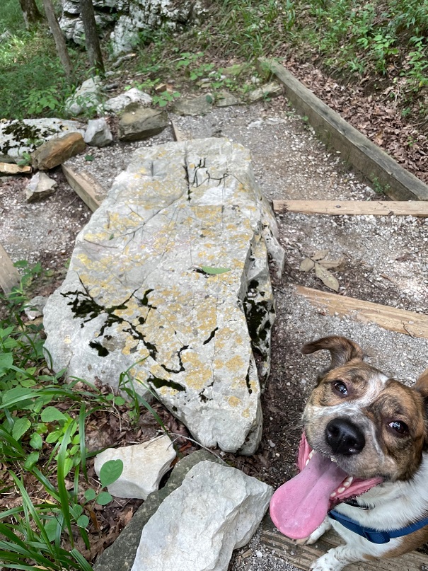
From scenic Tennessee, the Goddard hurtled northward in the summer of 2022 – destination: Michigan, to visit Nancy’s sisters and their families. On the way, we stopped to visit a couple of national parks in Kentucky and Indiana. We’d visited Mammoth Cave, located in central-west Kentucky, some years ago (Nancy’s way into caves – like, way), but it was time for a return visit. We made not one, but two trips underground to visit different parts of the cave; on another day, Gunther also joined us for a fun hike above the surface of the earth.
Mammoth Cave’s story begins, as do so many of the tales recounted in this blog, 350 million years ago when this part of present-day Kentucky (and most of the rest of the current United States) was covered by a vast inland sea. Corals and shell-bearing organisms produced calcium carbonate (CaCO3), which precipitated out of the seawater to fall on the seabed below. There were a lot of corals and shellfish: the CaCO3 their bodies created gradually accumulated to develop a 450-feet-deep layer of sedimentary limestone at the bottom of the sea.
In the ensuing hundreds of millions of years, the sea retreated and the limestone was covered by more layers of shale and sandstone. Mammoth Cave is the world’s biggest example of a solution cave, meaning that it was created when rainwater percolated downward and picked up naturally occurring carbon dioxide in the air and soil to became very weakly acidic. Ten to 15 million years ago, the percolation dissolved enough of the limestone to allow greater volumes of water to flow through the crevices. The force of the Green River took it from there, cutting through the highly erosional limestone using both water pressure as well as a mild acidity present in the river. The passages of the cave closest to the surface are the youngest in the system: only about 2 million years old. While the protective layer of harder shale and sandstone is keeping the brakes on vertical erosion from rainwater, the Green River is still creating more Mammoth Cave under the earth today.
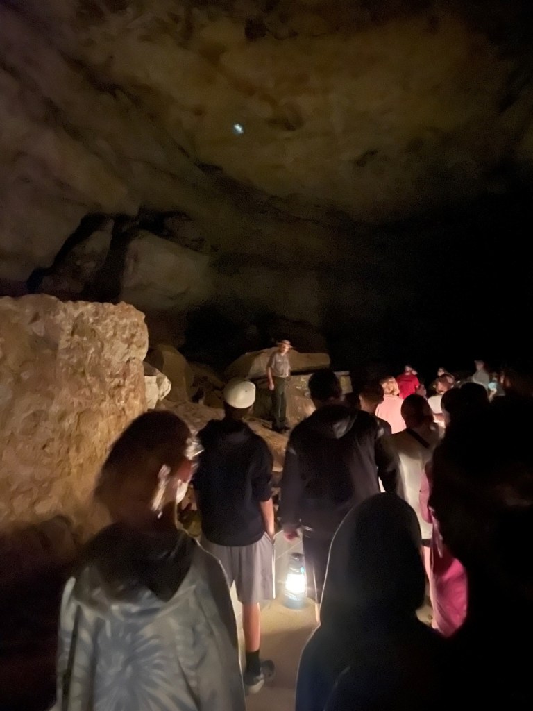
Our guide, National Park Service Ranger Matthew, a retired schoolteacher, welcomes the Star Chamber Tour group to the Historic Entrance of Mammoth Cave. Matthew is a retired schoolteacher. The tour, which started at 6 PM, allowed us to visit the cave as those who entered the cave a hundred years ago did: with oil lanterns. The Star Chamber tour is two miles long and lasted 2 1/2 hours; it was nearly full dark when we emerged from the cave. Ranger Quentin is behind the shrub in the center of the photograph; we talked with him a bit during the tour and he shared that he’d just been informed that he’d been named a full-time NPS ranger. As anyone who has spent time in national parks can imagine, it’s a very competitive position; Quentin is a native of the Cave City area, so it had to be especially rewarding.
Native Americans lived in the area around Mammoth Cave for thousands of years, exploring the cave and using it for mineral extraction. They entered the cave through what is now known as the Historic Entrance, and explored at least 14 miles of the system using only the flame from burning torches for light. Evidence shows that Native Americans stopped using the cave about 2,000 years ago, and the caverns were unknown for more than 200 years.
This is the Historic Entrance to the cave, accessed by a long stairway (the stairs seen at the right of the image above). There are about 30 entrances to the cave system, some of which are just small holes barely large enough to squeeze through.
Local history holds that the first European-American entered the cave in the late 1790s. A young boy named John Houchins was hunting black bear (no longer found in the area) and inadvertently came across the huge hole in the ground that is now the Historic Entrance.
During the War of 1812, the cave’s … significant … deposits of guano (there are 13 known bat species in the park, but not all use the cave) served our nation as a source of saltpeter, a component of gunpowder. Some of the wooden assets used in the guano mining operations are still to be observed in the cave, thanks to its cool and humid environment (54 degrees and 87 percent humidity, all day, every day, all the year round).
The site became a local tourist attraction but, because of the area’s remoteness, didn’t see much out-of-state visitors for many decades until the automobile was developed and popularized. The property was privately owned by different interests through the years, all of which conducted tours of the underground passages, until concern about preserving the caverns’ natural resources resulted in Mammoth Cave National Park being established on July 1, 1941. It is the country’s 26th national park. In its first year as a national park, Mammoth Cave saw about 58,000 visitors; we were two of about 663,000 people to visit the park in 2022.
True to its name, Mammoth Cave is pretty big: in fact, it’s the longest cave system in the world and fully twice as long as the next-longest system. Mammoth Cave is currently mapped to include more than 400 miles of caverns (the entire state of Colorado is 380 miles wide), and the scientists believe that as many as 600 miles of caverns remain to be discovered and mapped. The system has been likened to a bowl of spaghetti, with passages intersecting and moving up and down multiple levels .
Understandably so, flashlights and flash photography were forbidden on the cave tours so the photos I was able to take are terrible because the only light available came from lanterns (on the Star Chamber Tour) or electric lights along the cave passages (on the River Styx Tour). However, some of the photos give a sense of scale to the caverns. Much of the present-day caverns are completely dry – the river water that carved them disappeared quickly into deeper caverns many years ago – so there’s no dripping water to create stalagmites and stalactites, along with other formations familiar to spelunkers. To be honest, although there are some beautiful formations to enjoy, for me most of Mammoth’s impressiveness – and there is plenty of that – comes from its sheer size. Mammoth Cave is big, and it’s dark. I remember a ranger’s tale from the first time we visited the national park: in the mid-1930s, before the park was managed by the NPS, the mummified body of a Native American (who’d lived before Columbus reached the New World and was killed when he was struck by a large falling rock) was discovered on a ledge in one of the caverns. By that time, hundreds of guided tours had passed by the body and all of the people – numbering in the thousands, at least – in all of the tours were unaware that they were passing by the mummy, which was only a few feet above their heads. It was just too big, and too dark, in Mammoth Cave to know about the mummy until someone happened to come across it.
The pandemic limited the number of tours available; some of the tours that Nancy and I went on during our first visit weren’t available at the time of our visit in July (mostly because of a shortage of National Park Service rangers trained to lead the tours). However, we enjoyed the Star Chamber Lanternlight Tour one evening, as well as the daytime River Styx Tour on another day.
The cave’s corridors vary greatly in size: some passages require visitors to walk sideways in order to pass through, and other caverns are wide enough to accommodate a Boeing 747 jet (I didn’t see any aircraft on either tour, but it was pretty dark).
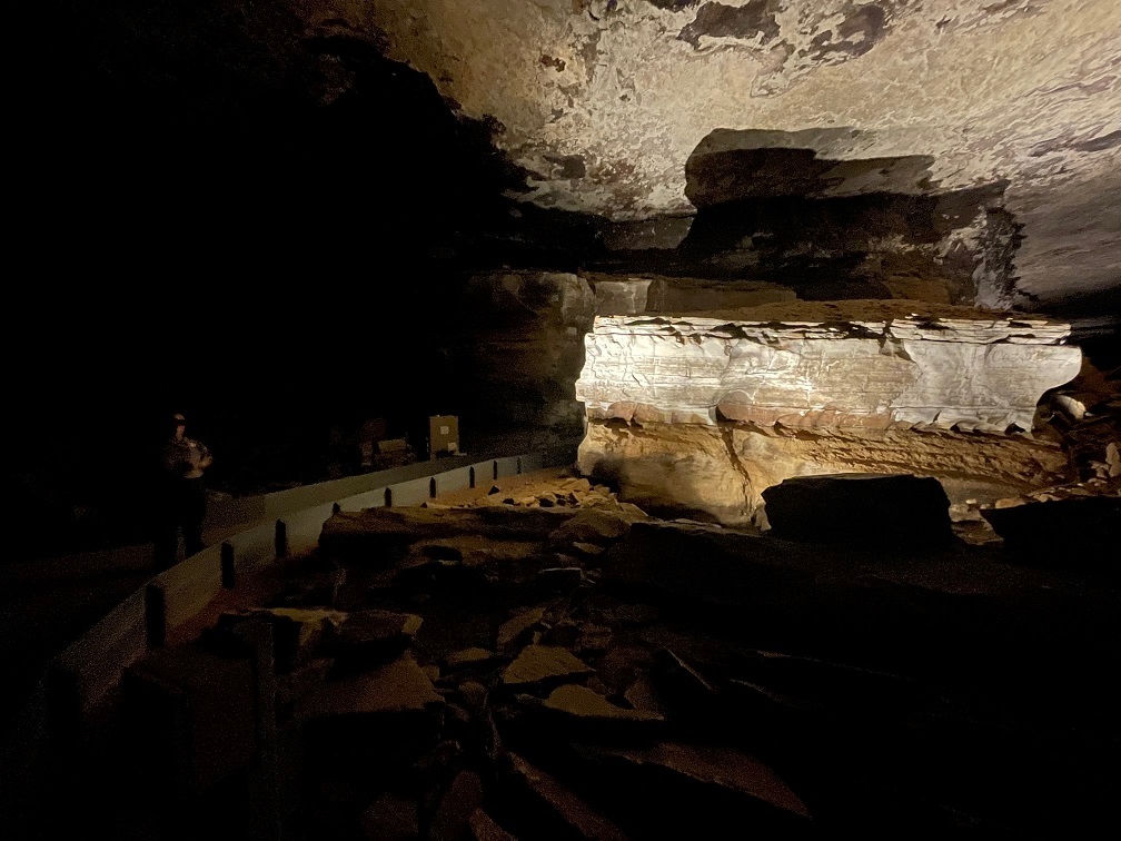
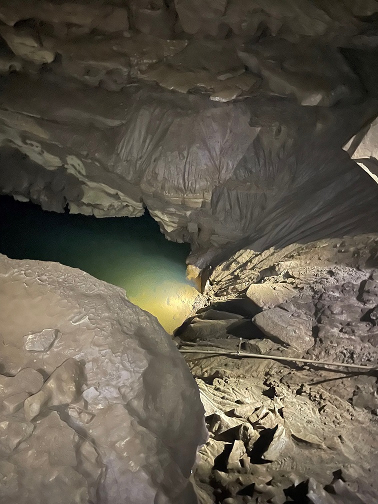
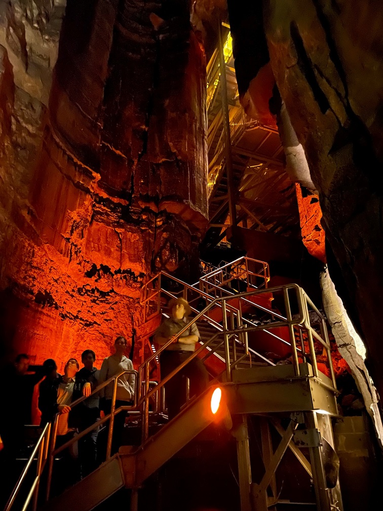
We saw this formation, called the Giant’s Coffin, on both of our tours (which shared a bit of the same trail). Located 175 feet below the surface, the Giant’s Coffin is a limestone nugget measuring nearly 50 feet long and 20 feet tall, and weighing a thousand tons. The rock separated from the limestone wall behind it sometime in the distant past; imagine the sound it made when it fell. Our NPS ranger guide is in the shadows at the left of the photo; if I remember right, she’s standing perhaps 50 feet in front of the Giant’s Coffin.At one point on the Star Chamber Tour, Ranger Matthew asked us to place our oil lanterns in a row on the cave floor. He and Ranger Quentin then extinguished all of the lamps and used a flashlight to guide their way behind a rock wall, leaving us in total darkness (he’d mentioned they’d do this beforehand; they didn’t just sneak off and leave us). If you’ve never been in a completely darkened cave, you’ve never known true darkness: the absence of all light. Even being outside on a moonless night, well removed from city lights, isn’t the same because there’s still starlight to provide some illumination, however feeble. It’s a common occurrence on cave tours, this extinguishing of all artificial light, but it never fails to strike some primeval chord – to not be able to see your hand in an inch in front of your face, let alone across the room. It also gives one a better appreciation for those early explorers: modern spelunkers carry all sorts of redundant sources of light – there are only so many torches or lanterns one can carry.This picture is from the River Styx tour, which was illuminated by electric lighting for most of the 2 1/2-mile trail. The tour includes a visit to the River Styx, an underground tributary of the Green River, but flooding in the cave in 2010 destroyed the electrical system along that part of the tour. We needed battery-powered lanterns to continue. (Incidentally, as of this writing in August 2023, the River Styx tour isn’t being offered – I wonder if the electrical system is being repaired.) Notice the scallop-shaped carvings in the rock ceiling above: those indicate the direction and velocity of the flow of water eroding the rock. Larger scalloped features (a meter or more wide) mean that the water was moving only a few centimeters per second, and smaller scallops indicate that the water was flowing in meters per second.This is a pool known as the Dead Sea, created by the Green River. It’s about 15 feet below the point at which this picture was taken. Artificial lighting next to the river shows some details of the water erosion. The occasional blind cave fish or blind crayfish can be observed in these waters; alas, they were not to be observed on this occasion.And here is the River Styx, which looks a lot like the previous photo of the Dead Sea. Bur remember, friends, that the River Styx is but a tributary of the Dead Sea’s Green River.Here was another highlight of the River Styx Tour: seeing the incredible Mammoth Dome. Known in spelunking terms as a “vertical shaft,” Mammoth Dome was created when water followed the law of gravity to flow straight down vertical crevices in the limestone. The erosional activity results in shafts that, at Mammoth Cave, measure 30 feet or more. In Mammoth Dome’s case, that resulted in a vertical shaft measuring 190 feet in height. An impressive metal staircase provided a lot of viewpoints to see the dome (there’s still a lot of climbing to do; see the top of the staircase at the top of the photo).
River Styx Spring Trail
While there are a number of different tours available for anyone wanting to explore the bowels of the earth at Mammoth Cave National Park, it also features more than 80 miles of above-ground trails. Gunther joined Nancy and me for a hike on the River Styx Spring trail, which provided for some great views of the Kentucky countryside.
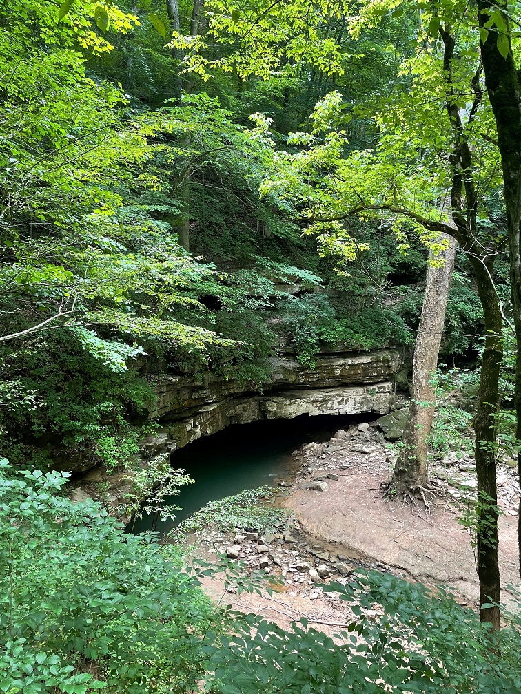
Because we spent most of our lives in Colorado, neither Nancy nor I are familiar with vistas like this: hardwood forests as far as the eye can see. Mammoth Cave National Park currently encompasses 53,000 acres, or about 80 square miles; while it’s justifiably most famous for its subterranean caverns, there are plenty of opportunities for above-ground adventures.We encountered this whitetail fawn near the trailhead of the River Styx Spring trail. Its mom was less than 10 feet away. It must be pretty used to seeing humans; I don’t think I’ve knowingly ever been this close to a young fawn before. The speckled pattern on a very young deer’s sides act as a kind of camouflage, helping it to blend in with the sun-dappled undergrowth in forests. I would think that fawns would also be predominantly grass-green instead of brown, but I suppose evolution knows what it’s doing.The River Styx Spring Trail passes by a historic cemetery that is the final resting place of Stephen Bishop, one of the first non-Native-American explorers of the cave system. Bishop’s story is very interesting: in 1839, the Mammoth Cave estate, along with several Black slaves including Bishop, were sold to Dr. John Croghan for the amount of $10,000 (about $275,000 today). Croghan began to explore making improvements to the property’s tourism assets, like the hotel, and Bishop began to explore the underground caverns. A gifted spelunker and popular guide, Bishop also named many features within the cave – including the River Styx. In 1844, he published a detailed map of the cave system; the map would remain the primary guide to the cave for 40 years. The map contained about 10 miles of passages within Mammoth Cave, half of which Bishop discovered himself. Croghan envisioned using part of the interior of the cave as a tuberculosis treatment facility – some of the stone housing built for tuberculosis patients in 1841 is still standing along present-day tours of the cave – thinking that the cave’s environment would provide helpful results, but the treatment failed. In fact, all 10 of the tuberculosis patients either died in the cave or later after they exited the cavern. Further, the widespread disease would claim the lives of both Croghan and Bishop: Croghan died in 1849, and had stipulated in his will that Bishop would be declared a free man seven years after Croghan’s death. Bishop did enjoy a few months of freedom beginning in 1856, but tuberculosis claimed his life in the summer of 1857. He was buried on the Mammoth Cave grounds but his grave remained marked only by a cedar tree until 1881, when a second-hand tombstone (it was originally intended for a Civil War veteran’s grave but the family never claimed it – explaining the appearance of a sword and flag on the headstone) was inscribed and placed at Bishop’s gravesite. The date of his death is incorrect on the headstone.Look at this rock Gunther found on the hike! Look at it! In addition to seemingly endless hardwood forest vistas, neither Nancy nor me nor Gunther were used to the high temperatures combined with the high humidity of central Kentucky in July. This part of central Kentucky gets about 50 inches of rain each year.Here is the terminus of the River Styx Spring hike: a view of the water feature we’d seen only underground. Presumably any fish or crayfish in this part of the river have the gift of sight.
A couple of birds
I’ll close with a couple of bird photos from our campground in Cave City, which is a little more than 10 miles from the Mammoth Cave National Park visitor center. This is, of course, an American robin (Turdus migratorius) that lit upon one of our campground’s picnic tables. They’re common birds but always fun to watch. They’re found throughout the United States but breed in Canada.Here was a new bird to me: an indigo bunting (Passerina cyanea). They’re found in the eastern United States and the southern part of the country. The scientists discovered that indigo buntings, which, like many other species migrate at night, and navigate using the stars. The experiment involved placing some of the birds in a planetarium. The birds adjusted their orientation in the room as the projected stars above changed position. Their remarkable blue color is due to microscopic structures in their feathers that reflect and refract blue light – very similarly to why the sky above the bunting looks blue.
There are a number of NPS sites that prominently feature caves including a couple, perhaps improbably, in South Dakota, which we visited a number of years ago (did I mention that Nancy likes caves?) However, none are bigger than Mammoth Cave in Kentucky, and, thanks to the Green River, it’s getting bigger every day.
Thank goodness we were done with caves for the year.*
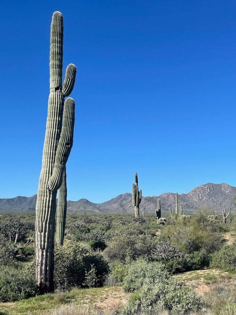
McDowell Mountain Regional Park is one of 14 parks in Maricopa County that have been preserved as open spaces and protected against private development – an important consideration for the Phoenix metropolitan area, one of the fastest-growing parts of the country. Some of the regional parks offer camping, and the Goddard spent two weeks in March in the shadow of McDowell Mountain, surrounded by saguaros and sparrows – along with a surprising diversity of other plants and birds.
Here’s a look at some of the Sonoran Desert birds we saw during that two-week stay. I was expecting to see at least some birds, but I wasn’t expecting to see some of the species that we actually did, nor the quantities of birds and different bird species that we saw. Keep in mind that most of these pictures were taken very close to our campsite – some were taken from our fifth-wheel’s steps – and all were taken no more than a quarter mile away from the Goddard.
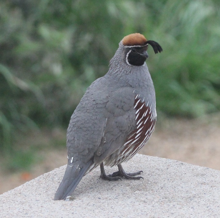
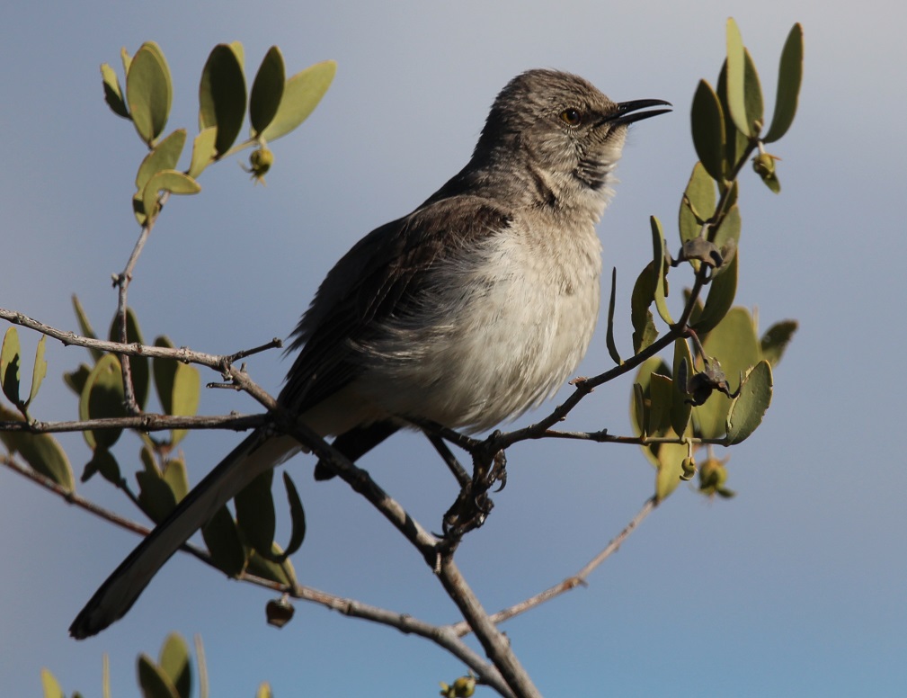
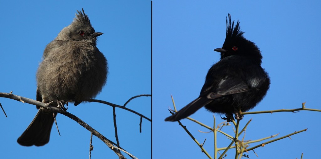
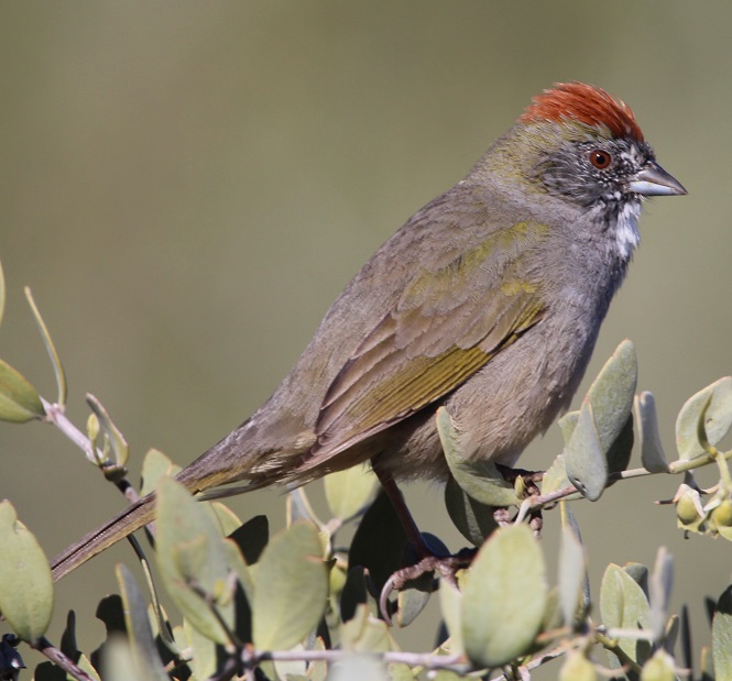
McDowell Mountain Regional Park, situated east of the city of Phoenix, protects just under 22,000 acres (about 34 square miles) of the Sonoran Desert for public use. The park is at the northern reaches of the desert, which itself contains more than 100,000 square miles stretching from southern Arizona down into northwestern Mexico and Baja California. There are plenty of saguaros and other cacti species in the park, along with a tremendous variety of other succulents, shrubs, wildflowers, and grasses. I’m working on a different blog posting that highlights the flowers that were in bloom during our stay in the park – I was really surprised at the variety.This is a female Gila woodpecker (Malanerpes uropygialis), one of the more characteristic birds of the Sonoran desert. Gila (pr. HEE-la) woodpeckers make their nests, containing 3-5 eggs, high up in saguaros, as seen here, and trees. In the United States, these birds are found only the extreme southern areas of the southwest. Male Gila woodpeckers look identical to the female, with the exception of a bright red cap on the top of their head.We’d seen Gambel’s quail (Callipepla gambelii) before, including at a campground in Deming, New Mexico. However, we’d never been close enough to get some decent photos. I took this while standing on the steps of the Goddard and this male quail was standing on our campsite’s concrete picnic table perhaps a dozen feet away. We saw quite a few of these beautiful birds during our stay at the park, and heard a lot more once we learned what their distinctive calls sound like (play the soundfile below, if you dare). Gambel’s quail nests contain between 10-20 eggs. The birds, native to the extreme southwestern United States and introduced in western New Mexico, are usually found on the ground, although we did see a few on top of saguaros (and our picnic table). Gambel’s quail are named after ornithologist and naturalist William Gambel (1823–1849), who at the age of 18 traveled overland to California. He was the first botanist to collect species in Santa Fe, New Mexico, as well as parts of California. A genus of southwestern U.S. lizards is also named in his honor.Nancy took this photo of a black-throated sparrow (Amphispiza bilineata) while perched in her camp chair right next to the Goddard; the sparrow was perched atop a buckhorn cholla that’s about to bloom. Both sexes of this species have the same plumage. These birds, also known as desert sparrows, are remarkably well-adapted to the hot and arid conditions of the Sonoran; during the heat of summer, they derive all the moisture they need from eating insects and seeds. Which is good: at the time of this late-afternoon writing in late July 2023 (we’re currently in southern Idaho), it’s 110 degrees at McDowell Mountain Regional Park. There are 26 species of sparrows in the United States, and most of them are generally brown. The black-throated sparrow is easy to identify, though. (Photo credit: Nancy Jardee)Although I’d read in the park’s literature that this species could be found in the area, it was still a pleasant surprise to see a loggerhead shrike (Lanius ludovicianus) while on a short hike around the campground. I’d never knowingly seen one before, but I’d read quite a lot about them: they feed mostly on insects but will also hunt for mice, lizards, and other small birds when times are tough. Additionally, although this one looks fairly innocuous (that savage hook at the end of his beak notwithstanding), shrikes impale their food on barbed wire or thorns as a means of storage, earning them the nickname “butcher birds.” This curve-billed thrasher (Toxostoma curvirostra) is perched atop a saguaro. I never did quite get used to seeing birds on top of cactus thorns, but I guess they don’t have a problem with it. When they’re not perched on a cactus, curve-billed thrashers spend a lot of time on the ground looking for insects. The look on these thrashers’ faces always reminds me of Sam the Eagle from “The Muppet Show.” I first saw one of these birds at the Tucson Botanical Garden.Since first seeing a northern mockingbird (Mimus polyglottos) near Tulsa, Oklahoma, in 2022, we’ve managed to see plenty of them all over the country. I wonder if it is due to the Baader-Meinhof Phenomenon, like when you learn a new word and then see it a lot in the next few days. Anyway, they’re fun to see and quite enjoyable to listen to – some are capable of learning 200 songs throughout their lives.While I wasn’t particularly surprised to see a northern mockingbird, I was surprised to see this northern cardinal (Cardinalis cardinalis) in the Sonoran Desert. It urns out that the species, while limited mostly to the eastern United States and Mexico, does have an established habitat in southern Arizona. Even though this guy was perhaps 75 yards away, he definitely caught my eye (I also heard his call to let me know in which direction to look). Only a few female bird species sing, and the northern cardinal is one of those species. Interestingly, northern cardinals don’t migrate – they stay in one location all year long.This is a composite image of a female (left) and a male (right) phainopepla (Phainopepla nitens), which are found in the southwestern United States and Mexico. We’ve seen them in Silver City, New Mexico, quite a bit. Absolutely beautiful birds. Their Latin name means “shining robe.” Phainopepla (pr. fay-no-PEP-luh) have evolved to eat mistletoe berries, which are low in nutrients but the birds can eat more than a thousand of them in a day. They can mimic the calls of other birds, including the Gambel’s quail. This is one of the species that has red eyes – there are several theories for that, but one I like is that there is a high concentration of blood vessels in their eyes to help with blood circulation. This pair liked to hang out on the same tree at the same time every morning – very dependable, which is a nice attribute for a bird. Here’s a first-for-me bird: the green-tailed towhee (Pipilo chlorurus). The species, which is only found in the western part of the country, migrates to the northern states for breeding but lives year-round in southern and central Arizona. They are very secretive and can be difficult to see. This guy was hanging out near our picnic table as I got back from a birding walk; I should have just stayed home.A small flock of white-crowned sparrows (Zonotrichia leucophrys) took up residence in a thorny thicket of mesquite along one of the hiking trails near our campground. This species, one of the few sparrows that’s relatively easy to identify, overwinters in the southern United States and is found seasonally all over the country, as well as Canada and Mexico – Alaskan white-crowned sparrows fly 2,600 miles to spend their winters in sunny southern California. One white-crowned sparrow was recorded flying 300 miles – about the distance between Colorado’s northern and southern borders – in a single night.One more sparrow, which I am 98% sure is a Lincoln’s sparrow (Melospiza lincolnii). They are found at least seasonally all over North America and Mexico, with the exception of the southeastern part of the country and extreme northern Canada. This species is not named after the luxury division of Fort Motor Company, as one might think, but rather after Thomas Lincoln, a chum of noted birder John James Audubon. Of the 26 species of sparrows, I can identify only three (house, black-throated, and white-crowned) conclusively. Anyway, almost 12 percent of the North American sparrows are on this blog posting.I’ll close with the cactus wren (Campylorhynchus brunneicapillus), one of the more characteristic birds of the American southwest. In fact, it’s the state bird of Arizona. It’s a noisy little guy, with a call that has been likened to someone trying, and failing, to start a car (reference soundfile below). They are one of the few bird species that roosts in nests throughout the year instead of only during the nesting season.
Nancy and I sort of started birdwatching before we sold our house two years ago, but we’re pretty full-bore into it now. We’re very fortunate to live the way we do, with opportunities to enjoy the tremendous variety of birds in different parts of the country.
We’re not the most expert birdwatchers on the Goddard, though. Rusty shows us how it’s done:
With the Goddard back in tip-top shape after a visit to an RV service center in Tishomingo, Mississippi, we headed back north to the east side of the Mississippi River and Memphis, Tennessee. Gunther and Rusty had both been boarded in Memphis during the Tishomingo work, and all four of us spent a little over a week camping at T.O. Fuller State Park in the southwestern corner of the city (it’s one of the rare state parks in the country that’s contained entirely within a major city).
The city of Memphis, Tennessee, was founded in 1819 and named after the ancient capital of Egypt, which, like the Tennessee city, is located on a prominent river. Nancy and I like Memphis a lot; we’d traveled to the city for a few days several years prior to our 2022 visit and really enjoyed the city’s cultural history, music, and food (which, in a great place like Memphis, all get kind of wondrously mixed up together).
Memphis is home to the National Civil Rights Museum, which incorporates the Lorraine Motel where Dr. Martin Luther King was assassinated in 1968. Memphis is home to Graceland, where Elvis Presley and his family lived, and where he recorded much of his music. Memphis was home to Sun Records, the recording company founded by Sam Phillips in which Presley, Carl Perkins, Johnny Cash, Jerry Lee Lewis, and so many others got their start. Memphis was home to Stax Records, the studio that released incredible music by Carla Thomas, Booker T. & the M.G.s, Otis Redding, and Isaac Hayes, among many others. Memphis is home to world-renowned barbecue restaurants, and it’s home to a lot of establishments that offer the best of live rhythm & blues and soul music – many of which are on the famous Beale Street, which is itself an open-air celebration of music and food. I should mention here that Nancy and I like Memphis a lot, or maybe I already did.
When planning our trip north in the summer of 2022, then, it was an easy decision to include Memphis in our travels. We decided to park the Goddard at T.O. Fuller State Park – one of the few state parks in the country to be fully inside a major city.
The Goddard’s first destination following warranty repairs (bathroom pocket door back on track, gray water valve operational, and other minor things) in Tishomingo was the heavily forested T.O. Fuller State Park in Memphis, Tennessee, a short distance from the mighty Mississippi River – and directly across the river from our previous campground in West Memphis. It was, by far, the campground with the most overhead tree coverage we’d stayed in to that point, or since. It was so dark inside the Goddard in the daytime that we turned the interior lights on. It was also very, very humid in late June and early July, and the bugs were very, very loud — at times it was nigh impossible to carry on a conversation outside.The 1,138-acre T.O Fuller State Park is very near the east bank of the Mississippi River, and its forest provides habitat for a large variety of birds and animals. A number of hiking trails wind through the forest, which gave Nancy and me, who had both spent most of our lives in Colorado, an opportunity to see a number of plants and trees that were new to us. There were plenty of insects and birds, although, thanks to all of the dense foliage, I didn’t get any good photos of the latter – I did see my first-ever Mississippi kite, though, as it soared over the campground.
The park was a Civilian Conservation Corps project begun in 1938, and was opened as Shelby County Negro State Park – the first state park east of the Mississippi open to African Americans. In 1942 the park was renamed in honor of Dr. Thomas O. Fuller (Oct. 25, 1867 – June 21, 1942), an African-American educator, clergyman, and civic leader.
Dr. T.O. Fuller was the son of a North Carolina carpenter who’d had to purchase his freedom from slavery. Both of Fuller’s parents could read, and they encouraged their children to become educated as well. Fuller earned a master’s degree from Shaw University in Raleigh, North Carolina, and moved to Memphis in the early 20th century. He became an important leader in Memphis religious and political activities, and founded a real estate company that helped many African-American Memphians to purchase their own business properties in the city. Fuller also wrote a number of books that chronicled little-known histories of African Americans. (Photo courtesy of T.O. Fuller State Park.)
Preserving the park’s history as a CCC project, T.O. Fuller State Park today also offers a wealth of recreational activities, including hiking trails, playgrounds, an Olympic-sized swimming pool, and ballfields as well as basketball and tennis courts.
A couple of state park rangers were kind enough to take Nancy and me on a nature hike one early afternoon. We saw quite a few butterflies, including this black swallowtail (Papilionidae polyxenes). In addition to being absolutely lovely to observe, nsects like this species are important pollinators for flowering plants.
Chucalissa
When we made our plans to camp at T.O. Fuller State Park, we had no idea that an important archeological site is within its borders. While digging in the earth for the park’s construction in the 1930s, workers uncovered evidence of a Native American culture that had lived on the bluffs overlooking the Mississippi River. Archeologists called the site Chucalissa, a Choctaw word that means “abandoned house,” for the site. A Memphis Press Scimitar article from 1940 related that Chucalissa “was literally ankle-deep in crumbling bones, bricks, and ancient pottery.”
A research team from the Works Progress Administration began excavating the site and found the remains of a large village with ceremonial and burial mounds. It’s believed that Chucalissa was built beginning around the year 1000, and was occupied until around the time of European exploration of the American continent in the 1500s. The Spanish explorer Hernando de Soto visited other villages along the Mississippi, but it’s thought that Chucalissa had already been abandoned by the time he reached the area around present-day Memphis.
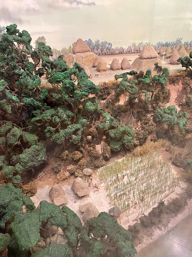
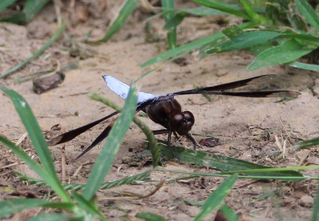
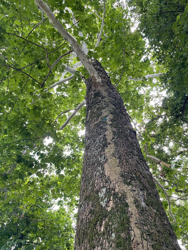
The museum at Chucalissa includes this interesting diorama representing what the scientists believe the village looked like, complete with homes and other buildings, as well as crops growing next to the Mississippi River.This view, looking west toward the Mississippi River on the other side of the trees, is the site of the village’s plaza as it looked on the day Nancy and I visited Chucalissa. The area is defined by three residential ridges. Archeologists believe construction of the large mound on the right side of the photo started around the year 1350, when Chucalissa’s population was at its peak. Researchers rarely find any artifacts in open areas like this. That lack of materials, along with the European explorers’ documentation of how southeast Native American peoples used open spaces in the 1500s, leads to the belief that the plaza was used much as town squares and parks are used today: a shared place for people to gather.We saw a lot of these dragonflies, called common whitetail skimmers (Libellula lydia), while walking around Chucalissa. The species, which measures about 1 3/4 inches long, prefers to perch on the ground. Male common whitetail skimmers, like this one, develop a white powdery substance, called pruinosity, on their abdomens; the females have brown abdomens. The males raise their bright abdomens to warn other males against intruding on their territories. This species is apparently found all across the country, but I’d sure never seen one.We’ve enjoyed seeing new animals in different parts of the country, and we’ve also had the opportunity to see plants that are new to us. This beautiful tree growing near the Chucalissa visitor center is an American sycamore (Platanus occidentalis). They can grow up to 100 feet tall and have the largest trunks of any native American tree, with some specimens having trunk diameters up to 15 feet. To accommodate that growth, the tree often sheds its bark in large pieces. The American sycamore is very common in the eastern part of the country, but the furthest west it grows is the eastern parts of Kansas, Oklahoma, and Texas. American sycamores commonly live for 200 years, and some can grow for more than twice that. The wood is used to make butchers’ blocks, as well as furniture and musical instruments.
It’s interesting to note that when archeologists were excavating the thousand-year-old Chucalissa site, they happened to pull some much more recent artifacts from the ground: farming tools and household goods from the 1800s. They were left by African-Americans homesteaders, who built their lives in the area now known as T.O. Fuller State Park. I like to think that it’s entirely possible that their descendants were aided in bettering their lives by T.O. Fuller himself.
Chucalissa was designated a National Historic Landmark in 1994. The grounds include a very fine museum, named after a prominent archeologist at Chucalissa, C.H. Nash, and a visitor center operated by the University of Memphis.
Seeing Chucalissa was a pleasantly unexpected aspect of our trip to Memphis. Having spent most of our lives in Colorado, Nancy and I are much more familiar with nomadic Native American tribes like the Arapahoe, Cheyenne, and Ute; since seeing more of the southwest, we’ve learned about the Apache, the Hopi, and the Navajo, as well as their ancient forebears. Chucalissa was our first experience of a culture that lived next to a tremendous river – and for nearly twice as long as the United States has been established.
More Memphis
Having visited the National Civil Rights Museum, the Stax Museum of American Soul Music, Graceland, the Memphis Rock ‘N’ Soul Museum on our previous trip to Memphis, Nancy and I concentrated our attention in 2022 on barbecue, Beale Street, and baseball. There’s a particular barbecue restaurant in downtown Memphis that we really like, and we made time to visit it twice while we were there last summer (and I’d go again, twice, right now). Beale Street was a little more muted than when we’d previously been in Memphis, but the pandemic and the fact that it was daylight outside probably had a lot to do with that. Then there’s baseball.
We took the opportunity to take in a Memphis Redbirds game at the ol’ AutoZone Park. The Redbirds are the AAA affiliate of the St. Louis Cardinals, who play their home games at the ol’ Busch Stadium 300 miles north of Memphis (it’s not really the “ol'” Busch Stadium; the current one opened in 2006, replacing the kinda ol’ Busch Stadium which had been built in 1966). AutoZone Park isn’t really ol’ either; it opened in 2000 with a seating capacity of 14,000 that has since been reduced to 10,000. The park offers great views of downtown Memphis buildings, as well as lovely cloud formations over western Tennessee.The Redbirds began play in 1998 as an expansion team of the Pacific Coast League. Memphis has a long history as a home of minor-league baseball teams, most notably the Memphis Chicks from 1901 through 1960. The Chicks started as the Memphis Egyptians, and then from 1909–1911 were the Memphis Turtles before changing their name to the Chickasaws – which was nearly always shortened to Chicks. AutoZone Park is a wonderful venue for baseball, and, because of the lack of outfield seats, it’s sometimes called “one-third of a major league ballpark.” The video scoreboard in this photo is the largest in the minor leagues, and it can be seen from many sites in downtown Memphis. Sadly, the Jacksonville Jumbo Shrimp bested the Redbirds that evening by a score of 5–1, but it was still a fun ballgame to watch.Finally, a bird photo. Memphis is home to the historic Peabody Hotel, which opened in 1925 and is on the National Register of Historic Places. Among the lovely building’s more famous attributes is the daily appearance of the ducks who spend the day cavorting in the lobby fountain. That’s a solid piece of Italian marble in the fountain. The mallard ducks live on the hotel’s roof (in very nice quarters; Nancy and I visited them when we were in Memphis several years ago) and descend to the lobby via the elevator (I’m not kidding) at 11 AM and waddle to the fountain on a red carpet (I’m still not kidding). They return to their penthouse digs, via the red carpet and elevator, every evening at 5 PM. If you’re in Memphis, it’s definitely worth seeing – but plan to arrive early for the arrival or departure, because the lobby gets pretty packed with Peabody Duck enthusiasts. I took this photo when Nancy and I ducked (!) into the Peabody last June while we were downtown to get some more barbecue.
It’s often said of many cities across the country and the world that “they’re nice places to visit, but you wouldn’t want to live there.” Despite having an abundance of things that make Nancy and me happy, like interesting history, lovely live music, and delectable food, we could never live in Memphis – neither of us do well in heat and humidity.
But Memphis remains a great place to visit, and I’m looking forward to the next time we’re there. And now I’m hungry for some barbecue.
We took the Goddard on an east-southeast course in the early summer of 2022 in order to get to our destination of Tishomingo, Mississippi, by late June for some warranty repair work on our home. Our travels took us through the states of Oklahoma and Arkansas, in which neither of us had previously spent much time .
In addition to seeing some new sites of interest, like the Philbrook Museum of Art in Tulsa, we also saw wildlife that was new to us since we were in an unfamiliar part of the country. Depending on where you live, these might be common in your area, but here’s a recap of the birds, new to us, we saw in Oklahoma and Arkansas while on our way to Tishomingo.
Northern mockingbird
We’ve seen many of these birds in the last 12 months, including in the western United States, but the first place we saw a northern mockingbird was about 20 miles west of Tulsa, Oklahoma. This one’s perched on a piece of playground equipment in the campground at which we were staying. Northern mockingbirds, as their Latin name Mimus polyglottos implies, are masters of mimicking the calls of other birds and even other animals and machinery. When we were camped in northern Tennessee later in the summer, a particular mockingbird perched in the campground went through a routine of perhaps 20 different calls every morning. Northern mockingbirds are noted for their intelligence, and are known to be able to recognize different humans. These are the state birds of five states: Arkansas, Florida, Mississippi, Tennessee, and Texas.
I recently finished reading Harper Lee’s novel “To Kill a Mockingbird,” in which a character notes that it’s wrong to kill these birds because “…. they don’t do one thing for us but make music for us to enjoy. They don’t eat up people’s gardens, don’t nest in corncribs, they don’t do one thing but sing their hearts out for us.” They’ve become one of my favorite birds to see and listen to, but they’re (understandably) difficult to identify by their calls alone.
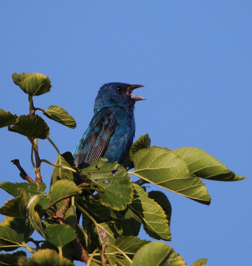
In this same campground, which featured a very nice walking trail along the Arkansas River, we saw two kinds of gulls, great egrets, great blue herons, Baltimore orioles, a northern cardinal, and an indigo bunting. Water makes a big difference when it comes to attracting wildlife.
Northern cardinal
This is not the best photo of this bright species that I’ve taken, but I’m including it because it was the first northern cardinal (Cardinalis cardinalis) I photographed (we’d seen another at the same Tulsa-area campground as above, but I didn’t get a photo). This guy (unlike northern mockingbirds, in which both genders look alike, there’s a clear difference in cardinals) was hanging out in the gardens at the Philbrook Museum of Art in Tulsa. Like the mockingbird, we’ve since seen this species in other places around the country, including in Grand Rapids, Michigan, and (improbably, I thought at the time) atop a saguaro cactus outside of Flagstaff, Arizona. Northern cardinals are very common in the eastern United States as well as a large swath of Texas and parts of Arizona. They do tend to stick out, even in heavy foliage, and they’re always a pleasure to see.
Eastern phoebe
Because we both grew up in Colorado and lived there most of our lives, anytime we see a bird with “eastern” in its name it’s likely new to us. Such is the case with this eastern phoebe (Sayornis phoebe), which is commonly found in the eastern part of the country and especially the south. This little bird, too, was perched on a tree at the Philbrook Museum of Art the evening we were there – it has a bright, very pleasant chirp of a call.
This is one of about 400 species in a group of birds called tyrant flycatchers, the largest group of birds in the world. They’re known for being rather plain-colored like this eastern phoebe [with some notable exceptions, like the scissor-tailed flycatcher (see below) and the vermillion flycatcher, which we saw in early 2023 in Tucson, Arizona]. Flycatchers subsist largely on airborne insects, like their name implies.
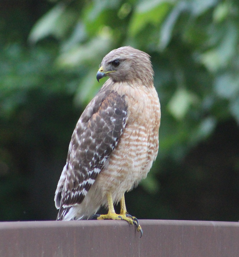
Red-shouldered hawk
This is the same bird that I wrote about in the blog posting about our visit to the gardens at the Philbrook Museum of Art, but I wanted to post this alternate photo because this red-shouldered hawk (Buteo lineatus) gave us plenty of opportunity to admire it while it perched on a bridge railing (until some ne’er-do-well kids came tramping along and scared it off, but whatever). Although there’s a small population in coastal California, this is an eastern United States raptor; Tulsa, in eastern Oklahoma, is on the very western edge of their habitat. They’re a little smaller than the red-tailed hawks that are common in the western United States. This species prefers the cover of heavily treed areas (which describes the gardens at Philbrook Museum of Art quite well). Up until around 1900, these birds were among the most numerous raptors in the United States, but deforestation and, until it was banned, DDT contributed to a marked decline in their population.
These last three birds, all seen in the same 25-acre space, give you an idea of the variety of species that can be enjoyed at botanic gardens – they’re great places to visit if you’re into birds.
Scissor-tailed flycatcher
From the Tulsa area we proceeded to western Arkansas, where we camped outside Russellville. There’s a fantastic municipal park on the Arkansas River near Russellville, where we saw several specimens of the spectacular scissor-tailed flycatcher to which I alluded earlier. This is the state bird of Oklahoma, but I guess they’re allowed to be in Arkansas as well (their habitat is the central-southern United States, including all of Kansas, Oklahoma, and Texas).
Want to know why they’re called scissor-tailed flycatchers? Scroll on!That’s why.
(The sign didn’t say “Dang,” by the way – I cropped out the “er.”)
((The “Danger” sign didn’t refer to the scissor-tailed flycatcher, by the way – it had something to do with boating on the river.))
Prairie lizard
TALES OF THE GODDARD LIZARD ALERT: Sharp-eyed readers will have already noticed that this is not a photo of a bird. This is most likely a prairie lizard, or Sceloporus consobrinus. Note, however, that I know next to nothing about lizards, so I could definitely be wrong. Whatever species it is, there were dozens of them at the park crawling around the cement steps leading down to the Arkansas River, which obviously delighted Nancy to no end as we climbed back up. Also, we’ve seen a lot more different lizards in the last year, so prepare yourself for lots of TALES OF THE GODDARD LIZARD ALERTS.
Northern rough-winged swallow
Finally, we made our way to the eastern side of Arkansas, right up next to the mighty Mississippi River, where we camped just a stone’s throw from the Mother of Waters. I’m fairly confident that these are northern rough-winged swallows (Stelgidopteryx serripennis), which were flying acrobatically over the river while hunting for flying insects. We really enjoyed watching them, along with their barn swallow cousins.This is a photo of a barge making its way up the Mississippi, just south of Memphis on the other side of the river from where we were camping. I’m including it because we spent a lot of time just watching these gigantic barges going up and down the river while hauling all kinds of cargo, and there’s also a swallow (dunno what kind) pictured just above the barge, in pursuit of a flying insect.
I kept a list of the different bird species we saw in 2022, and we ended the year with 86 species. As of this writing (late May 2023), we’ve seen nearly 70 species since the beginning of the year. Traveling about the country (although we’ve been only in New Mexico, Arizona, and, briefly, Utah in 2023) helps that number quite a lot, of course, as does keeping an open eye when one is out and about. There’s a lot of diversity out there, and it’s neat to see.
“The Air Capitol of the World” – it’s a bold thing to call a city. Our whirlwind tour of south-central Kansas concluded in late May 2022 with a trip to the Kansas Aviation Museum in Wichita. We soon learned that Wichita is wholly deserving of its “Air Capitol of the World” title.
By the way, in addition to the Air Capitol of the World, Kansas is also the location of the Disc Golf Capitol of the world, the Global Design Capitol of the World, the Barbed Wire Capitol of the World, the Cowboy Capitol of the World, and the Catfish Capitol of the World — and that’s just the first page of Google results.
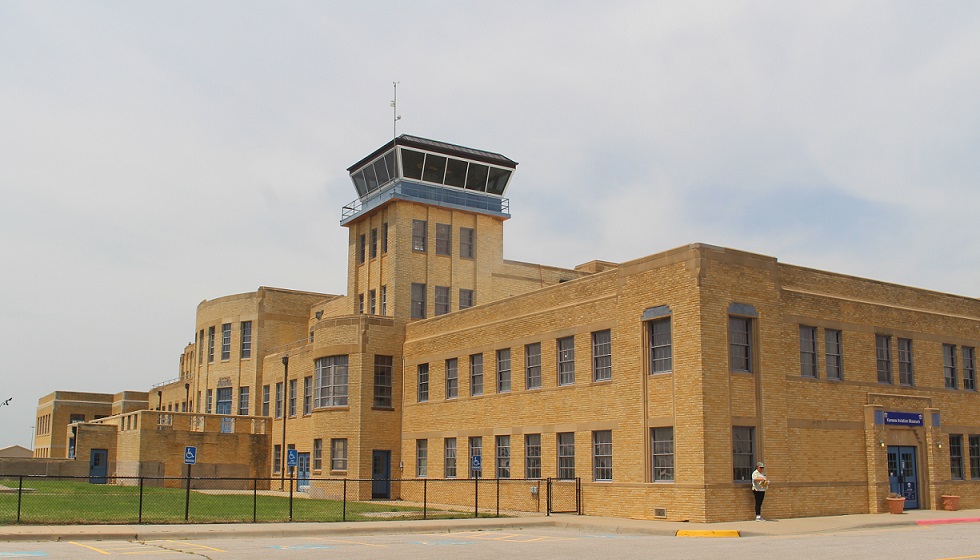
But back to the Air Capitol of the World, which is represented by the Kansas Aviation Museum. It’s really an outstanding museum that details the history of not just general aviation but aviation directly related to Wichita — which, as it turns out, also shares many of the names of the history of aviation in the United States: Cessna, Stearman, Beech, Boeing, and more.
The Kansas Aviation Museum is located in the terminal of the former Wichita Municipal Airport (ICT). Ground for the art-deco-style building was broken in 1930, but a loss of local and federal funding due to the Great Depression soon led to a work stoppage. Financial resources from the Works Progress Administration and President Franklin D. Roosevelt’s New Deal program allowed construction to resume in 1934, and the terminal building was dedicated on March 31, 1935. The control tower was added in 1941, and wings on either side of the terminal were added later in the same decade. (That’s Nancy at the corner of the building, waiting patiently for this photo to be taken; her patience was rewarded by being included in the photograph.)
The mid-continent location of Wichita Municipal Airport made it one of the busiest commercial airports in the country: in 1944, a takeoff or landing occurred every 90 seconds. World War II brought significant growth in Wichita’s aviation industry, including a decision by Boeing to build bombers and other aircraft in the city. That expansion, including a new U.S. Air Force base with 6,500 personnel, brought a lot of jobs to the city but it also necessitated relocating Wichita’s airport to a larger facility. By 1954, nearly all commercial and private air traffic was being managed at what is now National Dwight D. Eisenhower National Airport. The original municipal airport facility was used by the USAF and Kansas Air National Guard for a few decades, but the building was eventually abandoned by 1984.
The building and grounds are a perfect location for an aviation history museum, however, and the Wichita Aeronautical Historical Association, leasing the property from the City of Wichita, opened the Kansas Aviation Museum on April 19, 1991. The facility includes a number of large exhibits devoted to different aspects of aviation, including the Engine Room, which displays examples of propellers, landing gear, and engines, many of which were made in Wichita; exhibits detailing the history of Wichita-based aircraft companies like Beech, Cessna, and Ryan International Airlines; and many full-size original private and military aircraft.
Let’s start with a visit to the Engine Room, shall we?
Curtiss OX-5 Engine
This 8-cylinder engine, producing 90 horsepower and 1,400 revolutions per minute, was the powerplant of the Curtiss JN-4 airplane. Known as the “Jenny,” the Curtiss Aeroplane Company developed the aircraft as a trainer for the U.S. Army in 1915. So many pilots learned to fly in the Jenny that it was called “the airplane that taught America to fly.” Curtiss built a total of 6,813 Model JNs, ending production in 1927. The airplane remained very popular following World War I and was heavily used in the barnstorming craze that led to the rise of civil aviation in the United States. This engine weighs 390 pounds, about a third of the Jenny’s total weight of 1,390 pounds. Nancy and I saw a replica of a JN-3during our visit to Pancho Villa State Park in New Mexico in December 2021. The state park is the site of the former Camp Furlong, at which the first military airfield in the United States was built in 1916;.
Wright Whirlwind J-5 Engine
This important engine was introduced in 1925 to power a number of aircraft built in Wichita, including the Travel Air 2000, 3000, and 4000, as well as the Laird (later Stearman) Swallow (see below). An engine of this type drove the propeller of the Spirit of St. Louis, a custom-built monoplane, across the Atlantic Ocean during Charles Lindbergh’s first solo transatlantic flight in May 1927. The Wright Whirlwind produced 220 horsepower at 2,000 RPM.
1934 Link Trainer AN-T-18
When I first saw this machine from a distance, I thought it was a toy. Edwin Link’s family produced pianos and organs, and Link used that experience with valves, bellows, and pumps to develop this instrument flight simulator. The machine used organ bellows to make the trainer pitch, roll, and yaw in response to a pilot trainee’s movements.
I wasn’t terribly far off from thinking it was a toy, though. The U.S. Army Air Corps didn’t think much of the simulators at first, and the first sales of the trainer came as carnival rides. However, when 12 Army pilots were killed in a 78-day period due to their lack of training in flying under instrument conditions, the Air Corps was compelled to find a solution. In 1934, Edwin Link flew to a meeting in foggy conditions that were perceived as unflyable, and the Army Air Corps ordered its first six Link Trainers at a cost of $3,500 each. During World War II, more than 10,000 Link Trainers were built to familiarize more than 500,000 U.S. Army and Navy pilots with flying under instrument conditions.
Here’s a pretty nifty display of wooden airplane propellers, all of which were made in Wichita (the one in the middle was constructed by the Supreme Propeller Co. of Wichita).
Cessna 206 Super Skywagon Wing
Along with engines and propellors, this section of the museum illustrated how aircraft wings work. The elliptical design of the wing provides lift when the airplane is pulled forward by a propeller or pushed from behind by a jet engine. This is the left wing of a 1964 Cessna 206. The six-seat Super Skywagon was introduced in 1964 and remained in production until 1986 when Cessna ceased production of single-engine aircraft. The company reintroduced the 206 in 1998 and the aircraft remains in production. The 206 model, renowned for its stability and reliability, could carry a thousand pounds of passengers and/or cargo, which led to it being known as “a flying pickup truck.” See below for a picture of a Cessna 206 with both of its wings, along with all its other parts.
General Electric/Allison J35-A-13 Turbojet Engine
In addition to propeller engines, the museum has a good selection of early jet engines. This jet engine was first developed by General Electric in 1946, but the Allison division of General Motors took over production of the engine the following year. More than 14,000 of these engines were built by the time production of the J35 ended in 1955. It was used in a number of experimental aircraft, as well as the production fighters North American FJ-1 Fury, Northrop F-89 Scorpion, and the Republic F-84 Thunderjet (see below). This engine weighs more than 2,800 pounds and produced 5,200 pounds of thrust.
Now, on to the West Hall’s display of vintage aircraft.
Replica of an early 1920s Laird Swallow
E.M. Laird Airplane Company was formed in Wichita in 1920. The company’s first airplane, the Wichita Tractor, took flight on April 8 of that year, and an onlooker remarked, “She flies like a swallow, boys.” The Laird Swallow was the first commercially produced aircraft in the United States, and only 43 models were constructed. No original Swallows are known to exist, thus this replica (from which the sides of the fuselage have been removed so one can see the inner workings). The Swallow had a top speed of 86 MPH.
An interesting note: a couple of the original principals of the company, Lloyd Stearman and Walter Beech, would later join with Clyde Cessna and Walter Innes to create the Travel Air Company in 1925. Travel Air was the biggest aircraft manufacturer in the United States three years later, and was the prime contributor to Wichita being named the “Air Capital City.”
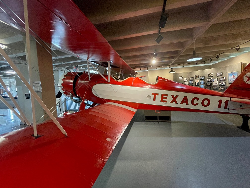
1931 Stearman Model 4D
Developed in 1930 from earlier Stearman designs, the Model 4 was developed with a deeper fuselage and more powerful engine that enabled it to carry heavier cargo loads than its predecessors. This is one of only four Model 4Ds to have been constructed, and a total of 41 Model 4 variants were finished. Stearman Model 4 aircraft were in the fleets of Varney Airlines (now United Airlines), American Airways (now American Airlines), and Standard Oil Company. This particular craft, which sold for about $16,000, was first used by Texaco Oil Company until its retirement in 1936. It was later used for crop dusting, and still later for mosquito control for the Tennessee Valley Authority in Alabama. It had a top speed of 145 MPH and a range of 500 miles, weighing 3,800 pounds. Its wingspan is 38 feet and the length is just shy of 27 feet. The Kansas Aviation Museum completed the restoration of this beautiful airplane, featuring its original livery, in 2014.
1944 Beechcraft D175 Staggerwing
During the U.S. Great Depression, aircraft executive Walter Beech and airplane designer T.A. “Ted” Wells collaborated on a biplane project intended solely for the use of business executives. The Beechcraft Model 17, later known as the “Staggerwing,” first flew on Nov. 4, 1932. The aircraft got its nickname because of the wing configuration: the upper wing was placed behind the lower wing to improve pilot visibility. This aircraft featured retractable landing gear, which was not common at the time, and boasted a range of 670 miles with a top speed of 212 MPH. The wingspan is 32 feet and the craft is almost 27 feet long, with a gross weight of 4,250 pounds. Note that the Wichita Municipal Airport was not originally designed to display aircraft in its interior, and part of the fun of visiting the museum is wondering how the airplanes got into the building for display.
Before going outside to see the aircraft on display out there, take a look at the ceiling above you:
Throughout its usage, beginning as an important midcontinental airport through which aviation luminaries such as Amelia Earhart and Charles Lindbergh walked, up to today’s usage as a museum, the building’s art-deco inspiration has remained intact. These ceiling treatments also acknowledge the building primary use: a home – temporary or permanent – for airplanes.
Now, let’s proceed outside for a look at a few of the 14 aircraft on display.
Republic F-84 Thunderjet
Republic Aviation, based on Long Island, New York, is famous for its design and production of several World-War-II-era and post-war aircraft, including the P-47 Thunderbolt fighter, the F-105 Thunderchief, and the F-84 Thunderjet. First flying in 1946, the Thunderjet was plagued by a variety of problems that nearly caused the U.S. Air Force to cancel the program. However, after some significant design improvements, the F-84 became the Air Force’s primary strike aircraft during the Korean War and would fly more than 86,000 sorties during that conflict. The Thunderjet was the first production aircraft to be capable of inflight refueling, as well as the first fighter that could carry a nuclear weapon. The F-84 was also the first aircraft to be used by the Air Force Thunderbirds aeronautics team. More than 7,500 F-84s were built. The General Electric/Allison J35-A-13 turbojet engine, shown above, was used in the F-84. With later variations and improvements in performance, the F-84 could fly up to 622 MPH.
Lockheed T-33B Shooting Star and Boeing B-52D Stratofortress
First flying in 1948, the Lockheed T-33 (shown in foreground) was used by the U.S. Air Force and Navy as a trainer for its jet pilots. More than 6,500 Shooting Stars were manufactured until production ceased in 1959. In addition to the United States, military branches of 43 other countries used the T-33 to train their pilots. The last operator of the T-33, the air force of Bolivia, retired its aircraft in 2017 after having used Shooting Stars for 44 years. The T-33 had a maximum speed of 600 MPH.
You might also notice the Boeing B-52D bomber, the big boy in back of the T-33. Introduced by Boeing in 1952, the jet-powered Stratofortress continues to be in service with the U.S. Air Force and is expected to remain so into the 2050s. It has outlasted more advanced bomber models introduced after it, like the Convair B-58 Hustler, the Rockwell B-1 Lancer, and the Northrop Grumman B-2 Spirit. Originally manufactured in Boeing’s Seattle plant, the B-52 was built in Wichita beginning with this B-52D model in 1957 and continuing through the B-52H model in 1963. A total of 742 B-52s were built in Seattle and Wichita, and about 50 of them are still in service. Powered by eight Pratt & Whitney turbofan engines, the final B-52H production model has a maximum speed of 650 MPH, a service ceiling of 50,000 feet (nine and a half miles above the Earth) and a ferry range (when fully loaded with fuel) of just over 10,000 miles and a combat range (while carrying ordinance) of 8,800 miles. For reference, the diameter of the Earth at the equator is 7,917 miles. With a wingspan of 185 feet, as Nancy pointed out, if a B-52 was parked so that its nose was on the 50-yard line of a football field, its wings would stretch to each of the 20-yard lines (as a comparison, a Boeing 737 passenger airliner has a wingspan of about 117 feet).
Boeing B-47 Stratojet
We saw an example of this bomberin Albuquerque, New Mexico, during a visit to the National Museum of Nuclear Science & Historyin late 2021, but it was fun to see this aircraft on display in the city in which, like the B-52D above, it was built – the first B-47 was manufactured in 1951, in Wichita. The B-47 was the U.S. Air Force’s first swept-wing bomber capable of flying at both high altitude and supersonic speed, with a maximum speed of 607 mph and a ferry range of more than 6,400 miles. When you fly on a commercial jet airliner today, you’re benefiting from technology and aeronautic advancements that were first made with the development of the Stratojet.
Cessna 206
It’s really rewarding to see examples of Wichita-made military aircraft that, in addition to helping protect our country, led to the development of so many aeronautical innovations we take advantage of when taking a cross-country (or cross-ocean) flight. For me, however, whenever I think of Wichita aircraft companies, my mind first goes to Cessna. My dad, Steve Goering, was born and raised just north of Wichita and got his private pilot’s license as a very young man. He has piloted Cessna models 150, 170, 172 and 182, along with a number of other fixed-wing aircraft and helicopters. This is an example of a Cessna 206, an extraordinarily popular model of aircraft (along with the models 205 and 207) that is used for commercial air service as well as personal use such as aerial photography.
Cessna was founded in Wichita in 1927 by Clyde Cessna and a partner, who quickly sold his share of the company to Cessna. The company was purchased by General Dynamics in 1985, and then by Textron in 1992. It, along with Beechcraft and Hawker Aircraft companies, is now a brand of Textron.
We’ve been to a number of aircraft museums in the months since becoming full-time RVers, but the Kansas Aviation Museum sticks out for me simply because of the history that the city of Wichita has with the science of flying. Its displays will teach you how airplanes fly, either with engine-driven propellers or with jets, and provide you with up-close views of some of the most popular aircraft produced — many in Wichita — in the last 100 years. Seattle, Washington, can certainly be proud of its aviation history as well, but I don’t think there’s a museum showing the depth of home-grown aeronautical innovation – from this Cessna 206 to a Boeing Stratofortress – quite like Wichita’s.
One day – I think it was a Tuesday but I could definitely be wrong – about 35 million years ago, a volcano began erupting in what is now southwestern New Mexico.
Somewhat later, on January 8, 2023, Nancy, Gunther and I visited City of Rocks State Park, located about 20 miles south of the caldera that produced the eruptions. The pumice and other rocks produced by the volcano’s eruptions 35 million years ago form the main feature of the state park, which also has a number of interconnected hiking trails, developed campsites, a botanic garden, and even an astronomical observatory.
We’d planned to visit he park, which is located halfway between Deming and Silver City, New Mexico, just a few miles east of U.S. Route 180, several times in 2021 and 2022 when we were camping in Deming and Silver City. However, the 35 mile-per-hour winds each of those days convinced us to find something else to do. The morning of January 8 was bright and calm, and we made the short trip to the state park. We’re all glad that we did.
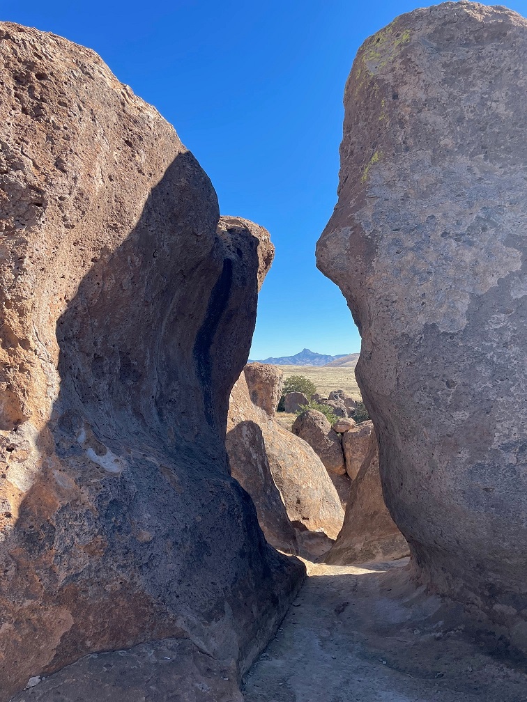
You’ll find plenty of prickly pear cactus at City of Rocks State Park in New Mexico, along with a wide variety of other plants. In the background, a vehicle provides a sense of scale for the namesake rocks near the park’s visitor center.
The park, at an elevation of just over 5,200 feet, gets its name from several tall outcroppings of rock that have eroded over the past 35 million years into pinnacles and other formations, separated by lanes that resemble city streets between tall buildings.
Here we see an amateur geologist, with her professional dog, on one of the park’s trails. They appear to be in disagreement about which direction to proceed. The park has about five miles of trails, some of which wind directly through the rock formations. Many of the pinnacles are 40 feet tall.
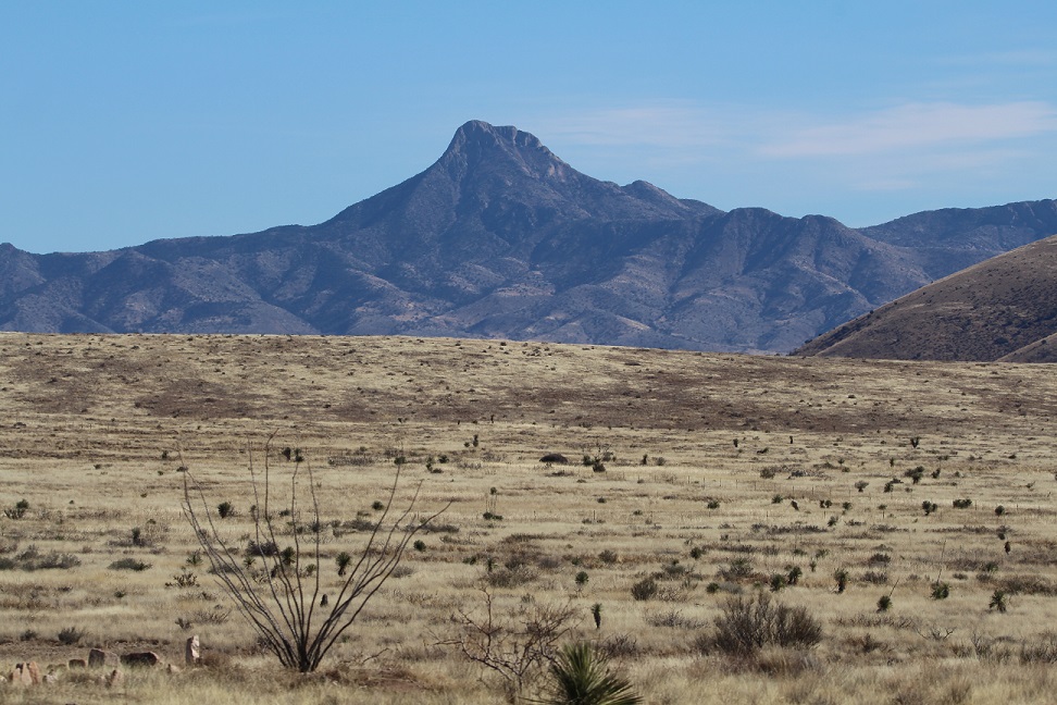
Paths between the rocks can get pretty tight. During the main phase of the volcano’s eruption, more than 240 cubic miles – about twice the volume of Lake Erie – of pumice and ash were ejected. This eruption also resulted in the “Kneeling Nun” formation east of present-day Silver City, 20 miles to the north. The pointed mountain seen between the two rocks is Cookes Peak (elev. 8,408 feet), a significant landmark in southwestern New Mexico. The mountain is directly north of the city of Deming.
The volcanic eruption that formed the formations of City of Rocks likely lasted several years and was about a thousand times larger than the Mt. St. Helens event in Washington on May 18, 1980. The eruption blanketed this area in a deep layer of hot ash and pumice. As those volcanic materials cooled into a rock called tuff, it shrank somewhat and vertical cracks in the stone were created.
They still haven’t agreed on a direction in which to hike. The park has a huge variety of succulents, like the soaptree yucca at the left of the trail, as well as many grasses common to the southwestern United States.
Over the last several tens of millions of years, the erosive forces of nature – water, wind, and organic growth – broadened the small fissures between the rocks into larger and larger crevices until the natural pathways seen today were created.
Now they’re both headed the same direction. The amateur geologist is standing in a crevice that is a conduit for water flowing through the rock formation. It’s that water, which carries abrasives like sand, that helped carve the rocks into the shapes we see today. Other contributors to the erosion include wind, which can also carry sand, as well as plant (and non-plant) life and the cycle of freezing and thawing water.
Many different groups of native Americans have lived in, or at least passed through, the area now known as City of Rocks. About 12,000 years ago, the last of the Ice Age glaciers were retreating and large mammals like mammoths and mastodons roamed this region. It’s likely that Paleoindians, like Clovis or Folsom peoples, hunted the large animals. Between 8,000 and 1,000 years ago, small bands of the Desert Archaic culture lived in the area and, toward then end of that era, began to build pit houses. Finally, the Mimbres culture occupied the area between the years 200 and 1150 AD. In addition to hunting animals and gathering food from plants, the Mimbres cultivated crops like beans, squash, and maize. They also built one-story above-ground dwellings.
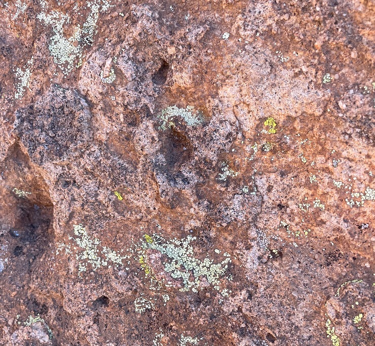
Do you like lichen as much as I’m likin’ this lichen? There are about 20,000 known species of lichen in the world, and at least four of them can be seen in this photograph. Lichen, which is plant-like but not an actual plant, contributes slowly but significantly to the erosion of rocks by chemically degrading the stones’ minerals. The scientists estimate that between 6-8 percent of the earth’s land surface is covered by lichen. Actual plants, like succulents, grasses and shrubs, also contribute to erosion by their seeds finding purchase in small crevices in the rock and then, as the plants mature, the growing roots of the organism can cause further fracturing of the minerals.
Getting up-close and personal with the rocks allows one to see some pretty fascinating natural patterns caused by erosion. I sure hope that whoever dropped those keys comes back by to pick them up! (Just kidding – they’re mine. Still need to go back and pick them up.)
Because the park is 25 miles from the nearest city of any size, it’s a popular site for stargazing at night. This structure is an astronomical observatory located near the main campground in the park. The roof slides back onto the supports in the back to reveal the telescope. It was not in operation during our visit (as you can see, it was daylight), but the park does host regular star parties during which the observatory is open and other amateur astronomers bring their own telescopes to share views of the night skies.
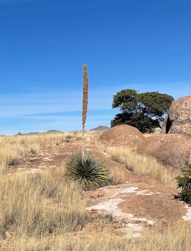
This magnificent succulent specimen, about 20 yards off the trail, is desert spoon (Dasylirion wheeleri). I didn’t want to get off the trail to take a closer picture, so this will have to do. The fronds of desert spoon were used by native Americans to weave baskets and mats, and its inner core can be fermented into an alcoholic drink, similar to tequila, called sotol. It is found in southern New Mexico and Arizona, as well as parts of Texas and Mexico. The plants themselves grow to about 5 feet tall, but the flowering spike can soar 16 feet into the air.
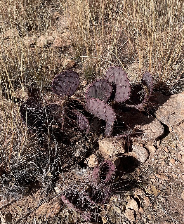
Here’s another interesting succulent found along the trail. This long-spined, purplish prickly pear is called long-spined purplish prickly pear (really) (Opuntia macrocentra). It, too, is found in Arizona, New Mexico and Texas, along with Mexico. Like other prickly pears, the fruit of this cactus is edible and is enjoyed by animals and humans alike.
But it wasn’t simply succulents we saw – we also spied several species of sparrows! Here’s a chipping sparrow (Spizella passerina) perched in some mesquite. We’ve enjoyed seeing plenty of these pretty little birds in southern New Mexico this winter.
While most of the pictures in this posting were taken with the camera on my phone, I used my digital camera to take this photo of Cookes Peak. The tall spindly shrub in the lower left corner is ocotillo (Fouquieria splendens), which can grow to more than 30 feet in height. It is native to the Chihuahuan and Sonoran deserts in the United States and Mexico. Native Americans used different parts of the plant to address a variety of ailments, and ocotillo can also be planted to serve as a natural fence.
A short spur off the main trail took us to the top of a 300-foot hill that provided a tremendous 360-degree view of the area. In this photo, the rock formations of City of Rocks are in the midground (the white streaks above the center of the photograph are campers’ recreational vehicles parked amongst the rocks, and the light brown building to the left of the RVs is the park’s visitor center). The tallest mountains on the left horizon are the Cobre Mountains, 16 miles away, and the Pinos Altos range, 30 miles in the distance, is just to the right of the Cobre Mountains.
This eye-catching grass is cane bluestem (Bothriochloa barbinodis), a valuable forage for ranchers but one of the first grasses to disappear if a pasture is overgrazed. The seed heads catch the sun in such a way as to look absolutely illuminated from within.
When we walk by a creosote bush (lower left), I like to rub my fingers on the leaves – they smell just like the air outside after a rainstorm. Along with seemingly every other plant, Native Americans found many medicinal uses for creosote. In the background is Table Mountain, the tallest point in City of Rocks State Park. The distinct layers of rock seen on the mountain’s slopes are due to different volcanic ashflows more than 30 million years ago..
If you plan to visit City of Rocks State Park, you’ll want to do make plans to do so soon-ish. The erosional forces that created the cracks between the rocks continue to degrade the stones even today (I mean, you saw all the lichen), and in several million years the whole area will just be flat.
Nancy and I definitely enjoyed our time in the park – it was a lovely day, with highs in the low 60s and very calm breezes, and the 4-mile hike gave all of us some great views and good exercise (Monday, January 9, was a day of relaxation and recuperation for Gunther). We plan to take the Goddard to the park in the next few years for some actual camping – it has more than 40 developed sites – and it has some other trails that we haven’t yet enjoyed.
In addition to the Cosmosphere, a world-class space science museum, the city of Hutchinson, Kansas, features another prominent attraction: the only salt mine in the country that’s open to the public. Have I got your attention yet? Read on!
Formerly known as the Kansas Underground Salt Museum, Strataca is owned by the Hutchinson Salt Company, which began operations in 1923 as the Carey Salt Company. Nancy and I visited Strataca in late May 2022.
The salt extracted from the mine is not the type that you’ll find in your kitchen salt shaker. There are a number of impurities in the mineral, which makes it ideal for managing icy roads and for feeding livestock.
Strataca’s story begins, as do all of the good ones, in the late part of the Paleozoic Era, known as the Permian Period, about 275 million years ago. Kansas, along with much of the rest of present-day North America, was covered by a vast inland sea. The waters eventually receded, leaving behind an immense deposit of salt that, over tens of millions of years, was covered with layers of shale and other sediments like sand, gypsum, and silt. That 275-million-year-old deposit of salt is now 650 feet below the Kansas prairie.
The museum has been at this location on the east side of Hutchinson since 1986. Of the 15 salt mines in the United States, Strataca (née the Kansas Underground Salt Museum; the name was changed in 2013) is the only one that is open for visitor tours. I’m trying to remember to take pictures of the exteriors of the museums we see; it seems that the American flags are flying at half-mast more often than not. We visited Strataca on Memorial Day.
A double-deck elevator takes two sets of up to 15 people each on a four-minute trip 650 feet down into the bowels of the earth. (It’s not really the bowels of the earth; the top crust of the earth, which makes up about 1% of the radius of our planet, has an average thickness of nine to 12 miles. In other words, the 650-foot elevator ride takes visitors down about 1% of 1% of the earth’s radius. Still, the elevator ride is pretty neat!)
Excavating the shaft for this visitor elevator was no mean feat. In addition to penetrating hundreds of feet of sedimentary rocks, the shaft also had to descend through part of the Ogallala Aquifer – one of the world’s largest natural underground reservoirs. The aquifer is about 130 feet thick at the site of the museum. To construct the shaft, engineers used liquid nitrogen to freeze the area of the aquifer immediately surrounding the planned shaft, then excavated the ice and replaced it with a concrete liner. The process was completed in 15-foot increments, and took just over a year between March 2004 and March 2005.
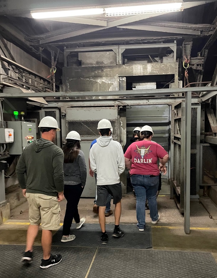
Upon exiting the elevator, visitors enter a large chamber filled with interesting exhibits that tell the wondrous story of sodium chloride (NaCl). As you can see, every visitor has to wear a hard hat. I jostled my way to get a blue one. The temperature in the mine year-round is 68 degrees Fahrenheit, with a relative humidity of 45%.
Let’s go back topside for a moment. This map, located in the museum’s visitor center, shows the extent of the mine (in yellow) with the rest of the city of Hutchinson to the west (left). The 1.5-square-mile mine is immense; if each of the excavated areas was lined up in a straight line, the chamber would extend for 150 miles. Pillars of solid rock salt, 40 feet square, are left to separate each chamber and support the upper level of salt.
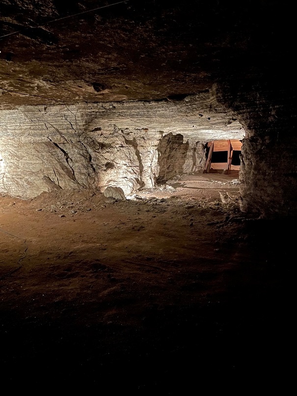
Okay, back down into the bowels of the earth 650 feet below the surface. Here’s a closeup of the salt deposit. As you can see, it’s quite different from the Morton’s that’s in your kitchen cabinet. The sodium chloride is mixed with a number of other minerals, including shale and sulfur compounds, which is why it’s primarily used to de-ice roadways.
The year 2023 will mark a century of mining by the Hutchinson Salt Company (formerly Carey Salt). It mines in the room and pillar process. This involves excavating, with the use of explosives, large chambers alternating with square pillars, measuring 40 square feet, that support the upper level of the mine. The process results in something of a checkerboard pattern, if it could be viewed from above. The mine’s chambers are very large, ranging from 2,500 to 15,000 square feet in size, with ceiling heights of 11 to 17 feet. The room and pillar method differs from traditional precious metal mining, in which miners follow the vein of gold or silver ore, for instance (unless it’s more cost-efficient to simply take an entire mountain apart, which seems to be happening more often).
Strataca has retained a lot of Carey Salt’s equipment from the early days of the mine (I’m guessing partly because it would cost time and money to return them to the surface, but it’s still fun to see the specialized equipment). The machinery is fairly well-preserved, considering the relatively high humidity; the salt can’t be good for metal parts, though. This machine was used to cut long slits at the bottom of a salt wall; when explosives in the wall were detonated, the slit ensured that the salt fragments fell forward into the chamber.
The excavation takes place in much the same way today, but using modernized equipment. The rock salt fragments are transported via conveyors to crushers, then taken to the surface using large buckets on a hoist. When operating at capacity, the skip, or mine elevator, can carry four tons of salt to the surface every three minutes. The skip is also used to transport miners into and out of the operation. Miners formerly used a rail system to move about the operation underground, but have since started using old junk cars that have been modified to run on bio-diesel fuel. Developed almost entirely from old cooking oil, the burning of bio-diesel doesn’t leave particles suspended in the environment. There are many instances of several generations of Hutchinson families being employed by the mine.
This was an interesting exhibit; it’s essentially a waste dump site. Early in the mine’s history, employees would leave their empty food packaging underground because it was more cost-effective to use the skip to transport either rock salt or miners. The salty environment, well away from the sun’s ultraviolet rays, has preserved the trash remarkably well; a lot of the sandwich wrappers and empty drink cups look like they were tossed aside last week instead of in the 1950s.
Nancy and I went on a couple of different guided tram rides through the mine. We got to see chambers that were excavated decades ago, using earlier mining methods. The mining company has placed a number of environmental sensors throughout the operation, which provide early detection of any possible shifting of the rock salt walls. The Mine Safety and Health Administration, which oversees operations in U.S. mines, considers this salt mine one of the safest in the world.
Nancy really enjoys being underground. I mean, really. She’d been looking forward to visiting the Hutchinson salt mine for a number of years, and we both had a great time. Luckily for us, our underground adventures were only beginning – we’d be able to descend into the bowels of the earth natural caves at two U.S. national parks in the months to come. Multiple times at each cave, even!
A salt mine might seem like something of a “so what?” kind of experience. But it’s the salt that comes from this mine, and others like it, that keep our roads safe to drive in wet and freezing weather. We’re glad we went, and, combined with the Cosmosphere, Strataca makes an excellent reason to visit Hutchinson.
Hutchinson, Kansas, seems to be an unlikely place for a world-class museum devoted to space exploration. The state’s main economic driver, by far, is agriculture: Kansas ranks in the top 10 states in the country for revenue from beef cattle, corn, hay, hogs, soybeans, sunflowers, and wheat (40 percent of all the winter wheat grown in the United States comes from Kansas).
However, the Sunflower State’s motto is “ad astra per aspera,” which, as you’ll recall from your Latin learnin’, means “To the stars through difficulties.” The motto is more a recognition that the state succeeded despite struggles with Black slavery, relationships with Native Americans reluctant to give away their homelands, and the U.S. Civil War than a resolution to actually travel to space, but I think it’s inspiring nonetheless.
Nancy and I visited the Cosmosphere in late May 2022.
This is a reproduction of the Bell X-1, the jet in which USAF Captain Chuck Yeager first broke the sound barrier (Mach 1, or about 700 mph) on October 14, 1947. The original X-1, Glamorous Glennis, is on display at the National Air & Space Museum in Washington, D.C. Fittingly, the original X-1 is next to the Spirit of St. Louis, in which Charles Lindbergh made the first solo transatlantic flight. The X-Plane program, of which the X-1 was the first craft, began in 1946 as a means of developing aerodynamics, engines, and other factors of high-speed and high-altitude flight. (The idea that the sound barrier was broken the year after the program’s start is, to me, kind of mind-boggling). The breaking of the sound barrier with a straight-wing aircraft came as a surprise to many aerospace experts, who believed that a swept-wing design was necessary for supersonic flight. X-1 flights ended in 1958, and by then the jet had flown at speeds approaching 1,000 mph and at altitudes close to 72,000 feet. In 24 years of testing, more than 40 X-Plane pilots were killed in expanding mankind’s knowledge of aeronautics. The experiments showed, however, that it was possible to break Earth’s gravitational pull and leave the planet’s atmosphere. They helped develop today’s vehicles that soar through our skies and the space around us. (Incidentally, and while it wasn’t necessarily built for speed, the Spirit of St. Louis had a top speed of 133 mph in 1927 – only 20 years before Yeager’s historic flight.)
The Cosmosphere (which is, again, smack-dab in the middle of Kansas) is home to the largest combined collection of U.S. and Russian spaceflight artifacts in the world. Numbering more than 13,000 pieces, the Cosmosphere’s collection is second to only the Smithsonian Institution’s Air and Space Museum for U.S. artifacts and is second only to Moscow for its number of Russian artifacts.
The Cosmosphere’s significant 1997 expansion gave it space to display one of the 20 surviving Lockheed SR-71 Blackbirds. The SR-71 first entered service as a high-altitude reconnaissance aircraft in 1966. The aircraft had a top speed of 2,200 mph (Mach 3.3) with a service ceiling of 85,000 feet, or about 16 miles (the scientists have determined that Earth’s atmosphere ends, and space begins, at about 62 miles above the planet). Lockheed built a total of 32 SR-71s; 12 were lost in accidents but none were destroyed by enemy aircraft (if an oncoming missile was detected, the Blackbird pilot simply went faster). The SR-71 (this particular model has Air Force serial number 61-7961) makes for a really impressive exhibit, but it’s difficult to get a photograph of the entire craft. This was the second SR-71 we’d seen in just two months, we saw AF model 61-7951 at Tucson’s Pima Air & Space Museum in March; most of the other 18 surviving Blackbirds are also on display at aircraft museums and Air Force bases around the country (one is in England)
Given Kansas’s agrarian economy, it shouldn’t be a surprise that the Cosmosphere started as a planetarium, with a used projector and rented folding chairs, in the Poultry Building on the Kansas State Fairgrounds in 1962. It was one of the first public planetariums in the country. Four years later, the planetarium moved to the campus of Hutchinson Community College. In 1980, the Cosmosphere was expanded to a 35,000-square-foot facility, which included one of the country’s first IMAX® Dome Theaters and a three-level exhibit gallery (my first and only other visit to the Cosmosphere occurred sometime in the mid-1980s, while visiting family in Kansas). The Cosmosphere tripled its size in 1997, becoming an impressive 105,000-square-foot facility with room for educational events and other programs.
If you thought that the Moon looked a little smaller after the Apollo 11 mission to the Moon in July 1969, it’s likely because Neil Armstrong and Buzz Aldrin brought back some rocks when they returned to Earth. On exhibit in the lobby of the Cosmosphere, this is one of the few Moon rocks on public display in the world. Armstrong and Aldrin collected this rock during a three-hour walk in the Sea of Tranquility on June 20, 1969. Its mineral composition is basalt, which is an igneous rock formed from rapidly cooling volcanic lava. It weighs just under 5 ounces – it used to be bigger but the scientists cut it in to smaller pieces in order to study it – and the same scientists say that it’s 3.84 billion years old.
The German V-2 Rocket
The Cosmosphere has several large independent exhibits that tell the story of how the space race developed. One of these exhibits focuses on the development of the Vergetlungswaffe 2 (“retaliation weapon 2”), the V-2 rocket, and it’s simply an outstanding experience, with interesting displays of original hardware and plenty of explanatory panels.
It’s safe to say that putting mankind in space, beginning with launching manned rockets into the sky in the early 1960s, progressing to the Apollo missions to the Moon that started in 1969, and continuing with programs like Skylab (1970s), the space shuttles (1980s), and the present-day International Space Station, started with weaponry development during the buildup to World War II. Simply put, many of the other rockets exhibited in the Cosmosphere wouldn’t have been possible without the development of the V-2.
The V-2 rocket on display at the Cosmosphere was discovered in an abandoned warehouse in Huntsville, Alabama. It was acquired by the museum in 1989 and restored by SpaceWorks, a division of the Cosmosphere. The project took several years and restored the rocket to how it would have looked in the period of 1942-1943. The seated figure near the front of the rocket represents a Jewish prisoner; many thousands of Jews were forced to work on the hazardous rockets.
The Nazis sunk incredible financial resources into the development of the V-2, believing it would turn the tide of World War II because of its ability to strike opposing targets from more than 200 miles away. The V-2 was developed by a team led by Dr. Wernher von Braun, a brilliant rocketry scientist whose early work was influenced heavily by the tests performed by Dr. Robert Goddard (early in his career, von Braun corresponded with Goddard regarding the latter’s experiments). Von Braun was very interested in sending mankind to space, and saw the V-2 program as a way to further his research into rocketry. His interest in space exploration almost led to his execution by German officials, who believed von Braun wasn’t sufficiently focused on creating a weapon of destruction and instead wanted to create a way to travel to the stars. Only the doctor’s relationship with a Nazi official who had Hitler’s ear saved his life.
The V-2 was the first long-range guided ballistic missile. Between September 1944 and March 1945, Germany launched more than 3,200 of the rockets at targets in England, Belgium, and other areas in western Europe. The rockets were fired from mobile launch pads, which made it extremely difficult for Allied forces to find and destroy the launch sites. A V-2 firing battery consisted of 152 self-propelled vehicles, 70 trailers, and more than 500 men. Each battery could fire up to nine missiles per day.
A V-2 rocket stood more than 46 feet tall, weighed 27,000 pounds and flew 50 miles into the sky, but the engine was just over five feet long and weighed just over one ton. Incredibly, that engine created 56,600 pounds of thrust while burning 33 gallons of alcohol and liquid oxygen every second.
The rocket carried a one-ton payload of high explosives to the edge of space, 250,000 feet above the earth, more than 200 miles to its target. When it began its return to earth, the V-2 reached speeds of 3,500 miles per hour – faster than the sound that it created, which meant that it exploded on the ground before the thunderous roar of its descent could be heard. Latter-day research has shown that a V-2 explosion created a crater 66 feet wide and 26 feet deep, displacing about 3,000 tons of material. From launch, the V-2 took only 4 minutes to reach its target (for reference, the width of the state of Colorado is a little less than 400 miles, or about twice the distance that a V-2 traveled).
V-2 attacks killed more than 1,700 Belgians in Antwerp, and injured 4,500 more. In London, more than 2,700 civilians were killed by the rockets, with an additional 6,523 injured. As horrid as those numbers are, it’s estimated that development of the V-2 cost the lives of as many as 20,000 people in Germany – most of them Jewish prisoners who died either from overwork or from accidental explosions.
In its time, the V-2 was a defenseless weapon – when everything worked. Fortunately, the rocket involved incredibly complex engineering and everything rarely worked. While the Nazis continually refined the engineering to improve the weapon’s efficiency, the V-2’s development came too late in the war to have the kind of impact the Nazis expected. By war’s end, the development of the V-2 (and its predecessor, the V-1) cost Germany the equivalent of $3 billion – roughly twice the amount of money that the United States poured into the Manhattan Project to produce the atomic bomb.
World War II is ripe for “what-if” scenarios, and the V-2 development is a good one. Considering that the V-2 had an insignificant impact on the war’s outcome, compared to the carnage that occurred otherwise, the money and manpower that it cost could have been allocated to the production of more fighter aircraft and anti-aircraft missiles. If the Germans had better control of the skies over western Europe in 1944, the Allied invasion on D-Day may not have been possible and the slow but steady encirclement of Berlin by Allied and Russian forces wouldn’t have happened.
The exhibit at the Cosmosphere does point out, however, that if the invasion at Normandy hadn’t been possible, Berlin – rather than Hiroshima – may have been the first target of the atomic bomb.
In the immediate aftermath of Germany’s capitulation, both U.S. and Russian forces were on the hunt for von Braun and his team of rocketeers. Both sides wanted the expertise and equipment, but von Braun surrendered to the United States and he and his colleagues were brought to this country. The V-2 was examined and led to the development of the Cold War’s intercontinental ballistic missiles (ICBMs), and, in the interest of science, the rockets that would carry mankind into space beginning in the 1960s.
I’ve struggled – a lot – with how to write about this particular blog posting; it’s one reason I haven’t posted anything for several months, and I considered leaving all of the V-2 material out of it. However, I think it’s important to not shy away from the fact that humans can be horrible to one another. I’ve read a lot about German’s leading up to and including World War II, trying to understand why humans can be horrible. I’ve also read extensively about Wernher von Braun, trying to understand why he contributed his considerable scientific intellect to the development of a terrible weapon that killed thousands upon thousands of innocent people, either in targeted cities or in forced labor. Von Braun was absolutely furious that the Russians were first into space, first with a dog and then with a man, but he lived to see the results of the Apollo program that sent the first men to walk on the moon – using technology that von Braun helped develop while he worked at NASA. I’ve come to the conclusion (and it’s open for revision) that von Braun really did want to expand the science of rocketry – to send mankind into space – and he was able to do that. I’m a big proponent of many facets of space exploration, but I need to be more cognizant that much of that research has come at horrific costs.
There are a great many other fine exhibits (of which I took a lot of photos that seem to have disappeared into the ether; that’s probably okay because this posting would be even longer than it is) at the Cosmosphere, and it’s well worth a visit when you’re in central Kansas. I think I’ve written about this before, that museums like the Cosmosphere are a great opportunity to stretch one’s mind. Even if museums don’t have all of the answers, and, perhaps particularly if they sometimes don’t, it’s never a bad thing to learn.
(Editor’s note: alert readers may note that I haven’t posted any updates on this blog for several months. We did lots of things between visiting the Barbed Wire Museum in May and White Sands National Park in November, but I’m going to post this now and fill in the months in between.)
On Thanksgiving Day, Gunther and Nancy and I went to White Sands National Park. It’s near the town of Alamogordo (Spanish for “fat cottonwood”), New Mexico, where we camping for a week. We were a bit surprised at the number of people who’d also chosen to visit the park on Thanksgiving, but, judging from the languages and accents we heard, we think a lot of them were tourists from Japan.
White Sands was first declared a national monument in 1933 and was re-designated as a national park in 2019. Nancy and I visited the then-monument during a trek through New Mexico in 2015, but were happy to share the experience again with Gunther. White Sands is the most-visited of the two national parks in New Mexico; a typical year sees 600,000 people stroll, slide, stumble, and tumble down its dunes. During the last two years, the pandemic increased that visitation to more than 700,000 visitors annually. (Carlsbad Caverns National Park, the state’s other national park, receives about 440,000 visitors each year. Two of those were Nancy and me; more to come on that.)
White Sands National Park is on the northern edge of the Chihuahuan Desert, which encompasses about 175,000 square miles. This desert, the largest in North America, stretches 1,200 miles from Alamogordo southward well into Mexico.
We took a walk on the park’s Interdune Boardwalk, which provides a lot of introductory information about the park’s ecosystems, and then hiked a two-mile loop in the dunes themselves along a marked trail where backcountry camping is permitted. There’s not a path in the dunes; the wind would scour away any trail in the sand within a couple of days. Instead, the route is marked with tall posts.
That’s a grass known as little bluestem (Schizachyrium scoparium) in the foreground. Little bluestem is very common throughout the Great Plains and the intermountain west, and can survive in the desert here at White Sands National Park because the water table is typically only two or three feet below the surface. While on our hike, we noticed that the sand between the dunes was actually pretty wet. The Tularosa Basin, which includes the town of Alamogordo as well as the national park and White Sands Missile Range, is bordered by the Sacramento Mountains on the east (in the background of this photo) and by the San Andres and Oscuro mountain ranges on the west. The Tularosa Basin is about one-third larger than the state of Connecticut.
Some more rather staggering numbers regarding White Sands National Park: the sand has an average depth of about 30 feet, some of the dunes are 60 feet high, and the scientists figure that the dunefield contains about 4.5 billion tons of sand.
This photo, taken from the passenger seat of the Goddard’s six-wheeled towing unit, shows not snow, but sand. White Sands National Park features the largest gypsum dunefield in the world: at 275 square miles, it’s so big that it can be seen from space. (Great Sand Dunes National Park in southern Colorado measures about 30 square miles and contains several different minerals.) Only about 40 percent of the White Sands dunefield is in the national park; the rest is in the U.S. Army’s White Sands Missile Range (WSMR), which surrounds the park, and is strictly off-limits to the public. WSMR has an area of 3,200 square miles and is the largest military installation in the United States (it’s 32% bigger than Kit Carson County in eastern Colorado). The national park is occasionally closed to visitors because of missile testing on the range. The world’s first atomic bomb, Trinity, was detonated on the northern edge of the missile range on July 16, 1945, as a test prior to the United States releasing atomic bombs in Japan to bring World War II to an end.
Here we see a visitor to White Sands National Park and her ill-behaved dog (it’s Nancy and Gunther) on the Interdune Boardwalk, a short elevated trail with many exhibits along the way. A good variety of desert plants, including shrubs, grasses, and cacti and succulents, thrive in some parts of the dunes.
The sand is remarkably white, and remarkably fine – most of the grains are smaller than crystals of table salt or sugar. Where did all of the sand come from? The answer lies, as many do, with the fact that this part of the planet was covered by a vast inland sea during the Permian Period (about 300-250 million years ago). The waters eventually evaporated away and left immense deposits of gypsum (also known as the mineral calcium sulfate) in the former seabed. Tectonic activity then uplifted the mountain ranges on either side of today’s Tularosa Basin. Over tens of millions of years, rain slowly dissolved the gypsum deposits in the mountains and ancient rivers carried the minerals to today’s White Sands National Park. The dunefield is relatively new, geologically speaking: it’s only 10,000 years old.
Gypsum has a number of beneficial uses for humans: it’s the prime component of drywall, which is used in building construction, plaster of Paris, and toothpaste. It’s also found in all kinds of food, including canned vegetables, white flour, ice cream, and in the production of both beer and wine; people ingest almost 30 pounds of gypsum during their lifetimes.
The mineral’s usefulness led to the designation of White Sands as a national monument in order to protect the area, and its plants and animal ecosystems, from commercial development.
Soaptree yucca (Yucca elata) is a really interesting desert succulent. Native Americans had more than 100 uses for the plant, including as a source of food, fibers for the manufacture of textiles, and true to its name, soap. The stem of the soaptree yucca, which grows underneath the sand, can be many times longer than the height of the plant above ground. As sand moves and threatens to cover the plant, the soaptree yucca continues to elongate its stem so that the plant’s photosynthesizing leaves stay above ground.
The seed pods of soaptree yucca (shown here in their dried form at the end of November) had many uses for Native Americans, and they’re also important to the desert ecosystem. The park is home to 800 different animal species, 650 of which are moths. Thirty-five of the moth species are found only at White Sands. Several different types of moths are responsible for pollinating the soaptree yucca, and they also lay their eggs in the flower pods.
One thing the scientists don’t know is why Gunther enjoys running on the sand so much. He did this at Great Sand Dunes National Park in Colorado, and he’s done it on beaches at reservoirs and lakes. He’s kind of a nut.
The wind carves the sand on the dunes into all kinds of interesting patterns of ripples, shifting nearly imperceptibly but constantly with every gust. I included the footprint in this crop of the photo to provide some scale; who knows who left it, and how many thousands of years has it been imprinted in the sand? (I left it, about five seconds before taking this photo.)
Here was a fun little surprise: I wasn’t expecting to find rubber rabbitbrush (Ericameria nauseosus) in the desert sand, but here it is. We planted several of these at our home in Denver, and they were hosts to hundreds and hundreds of bees, along with lots of butterflies, during their late summer blooms. Rabbitbrush’s pollen is important source of food for butterflies during their migration. Native Americans used the yellow pollen to dye textiles, and they used other parts of the plants to make baskets and arrow shafts.
We saw a few invertebrate species of animals, including some beetles, but we didn’t see any mammals during our hike in the dunes. The park is home to American badgers, coyotes, black-tailed jackrabbits, desert cottontails, bobcats, and several different rodents. Most of the larger animals beat the heat by being nocturnal: staying in their burrows until nightfall. I think some kind of bird left the tracks on the left, and I’m fairly certain the photo on the right shows tracks from a northern Chihuahuan desert wolf. (I’m just kidding with you right now; they’re Gunther’s.)
The northern Chihuahuan desert wolf Gunther stopped running around long enough for me to take this picture on our two-mile hike on the dunes. The lower areas between the dunes provide a sheltered and well-watered place for plants to grow. The black dot at the top of the dune on the left side of the photo is another hiker.
White Sands National Park is an incredible treasure. A short hike up a 60-foot sand dune rewards one with a wonderful view of mountains, sky, and … more sand dunes. Nancy and I wondered, while on the two-mile hike, what it would be like to camp on the dunes. It would probably be an eerie experience — quiet except for the wind and occasional coyote yip. The stars would be beyond beautiful at night, though – something to consider for another trip to the park.