Hutchinson, Kansas, seems to be an unlikely place for a world-class museum devoted to space exploration. The state’s main economic driver, by far, is agriculture: Kansas ranks in the top 10 states in the country for revenue from beef cattle, corn, hay, hogs, soybeans, sunflowers, and wheat (40 percent of all the winter wheat grown in the United States comes from Kansas).
However, the Sunflower State’s motto is “ad astra per aspera,” which, as you’ll recall from your Latin learnin’, means “To the stars through difficulties.” The motto is more a recognition that the state succeeded despite struggles with Black slavery, relationships with Native Americans reluctant to give away their homelands, and the U.S. Civil War than a resolution to actually travel to space, but I think it’s inspiring nonetheless.
Nancy and I visited the Cosmosphere in late May 2022.
This is a reproduction of the Bell X-1, the jet in which USAF Captain Chuck Yeager first broke the sound barrier (Mach 1, or about 700 mph) on October 14, 1947. The original X-1, Glamorous Glennis, is on display at the National Air & Space Museum in Washington, D.C. Fittingly, the original X-1 is next to the Spirit of St. Louis, in which Charles Lindbergh made the first solo transatlantic flight. The X-Plane program, of which the X-1 was the first craft, began in 1946 as a means of developing aerodynamics, engines, and other factors of high-speed and high-altitude flight. (The idea that the sound barrier was broken the year after the program’s start is, to me, kind of mind-boggling). The breaking of the sound barrier with a straight-wing aircraft came as a surprise to many aerospace experts, who believed that a swept-wing design was necessary for supersonic flight. X-1 flights ended in 1958, and by then the jet had flown at speeds approaching 1,000 mph and at altitudes close to 72,000 feet. In 24 years of testing, more than 40 X-Plane pilots were killed in expanding mankind’s knowledge of aeronautics. The experiments showed, however, that it was possible to break Earth’s gravitational pull and leave the planet’s atmosphere. They helped develop today’s vehicles that soar through our skies and the space around us. (Incidentally, and while it wasn’t necessarily built for speed, the Spirit of St. Louis had a top speed of 133 mph in 1927 – only 20 years before Yeager’s historic flight.)
The Cosmosphere (which is, again, smack-dab in the middle of Kansas) is home to the largest combined collection of U.S. and Russian spaceflight artifacts in the world. Numbering more than 13,000 pieces, the Cosmosphere’s collection is second to only the Smithsonian Institution’s Air and Space Museum for U.S. artifacts and is second only to Moscow for its number of Russian artifacts.
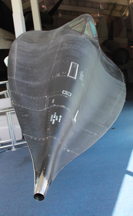
The Cosmosphere’s significant 1997 expansion gave it space to display one of the 20 surviving Lockheed SR-71 Blackbirds. The SR-71 first entered service as a high-altitude reconnaissance aircraft in 1966. The aircraft had a top speed of 2,200 mph (Mach 3.3) with a service ceiling of 85,000 feet, or about 16 miles (the scientists have determined that Earth’s atmosphere ends, and space begins, at about 62 miles above the planet). Lockheed built a total of 32 SR-71s; 12 were lost in accidents but none were destroyed by enemy aircraft (if an oncoming missile was detected, the Blackbird pilot simply went faster). The SR-71 (this particular model has Air Force serial number 61-7961) makes for a really impressive exhibit, but it’s difficult to get a photograph of the entire craft. This was the second SR-71 we’d seen in just two months, we saw AF model 61-7951 at Tucson’s Pima Air & Space Museum in March; most of the other 18 surviving Blackbirds are also on display at aircraft museums and Air Force bases around the country (one is in England)
Given Kansas’s agrarian economy, it shouldn’t be a surprise that the Cosmosphere started as a planetarium, with a used projector and rented folding chairs, in the Poultry Building on the Kansas State Fairgrounds in 1962. It was one of the first public planetariums in the country. Four years later, the planetarium moved to the campus of Hutchinson Community College. In 1980, the Cosmosphere was expanded to a 35,000-square-foot facility, which included one of the country’s first IMAX® Dome Theaters and a three-level exhibit gallery (my first and only other visit to the Cosmosphere occurred sometime in the mid-1980s, while visiting family in Kansas). The Cosmosphere tripled its size in 1997, becoming an impressive 105,000-square-foot facility with room for educational events and other programs.
If you thought that the Moon looked a little smaller after the Apollo 11 mission to the Moon in July 1969, it’s likely because Neil Armstrong and Buzz Aldrin brought back some rocks when they returned to Earth. On exhibit in the lobby of the Cosmosphere, this is one of the few Moon rocks on public display in the world. Armstrong and Aldrin collected this rock during a three-hour walk in the Sea of Tranquility on June 20, 1969. Its mineral composition is basalt, which is an igneous rock formed from rapidly cooling volcanic lava. It weighs just under 5 ounces – it used to be bigger but the scientists cut it in to smaller pieces in order to study it – and the same scientists say that it’s 3.84 billion years old.
The German V-2 Rocket
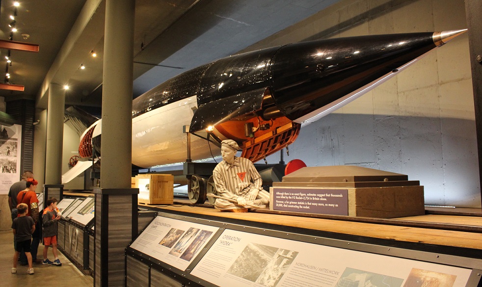
The Cosmosphere has several large independent exhibits that tell the story of how the space race developed. One of these exhibits focuses on the development of the Vergetlungswaffe 2 (“retaliation weapon 2”), the V-2 rocket, and it’s simply an outstanding experience, with interesting displays of original hardware and plenty of explanatory panels.
It’s safe to say that putting mankind in space, beginning with launching manned rockets into the sky in the early 1960s, progressing to the Apollo missions to the Moon that started in 1969, and continuing with programs like Skylab (1970s), the space shuttles (1980s), and the present-day International Space Station, started with weaponry development during the buildup to World War II. Simply put, many of the other rockets exhibited in the Cosmosphere wouldn’t have been possible without the development of the V-2.
The V-2 rocket on display at the Cosmosphere was discovered in an abandoned warehouse in Huntsville, Alabama. It was acquired by the museum in 1989 and restored by SpaceWorks, a division of the Cosmosphere. The project took several years and restored the rocket to how it would have looked in the period of 1942-1943. The seated figure near the front of the rocket represents a Jewish prisoner; many thousands of Jews were forced to work on the hazardous rockets.
The Nazis sunk incredible financial resources into the development of the V-2, believing it would turn the tide of World War II because of its ability to strike opposing targets from more than 200 miles away. The V-2 was developed by a team led by Dr. Wernher von Braun, a brilliant rocketry scientist whose early work was influenced heavily by the tests performed by Dr. Robert Goddard (early in his career, von Braun corresponded with Goddard regarding the latter’s experiments). Von Braun was very interested in sending mankind to space, and saw the V-2 program as a way to further his research into rocketry. His interest in space exploration almost led to his execution by German officials, who believed von Braun wasn’t sufficiently focused on creating a weapon of destruction and instead wanted to create a way to travel to the stars. Only the doctor’s relationship with a Nazi official who had Hitler’s ear saved his life.
The V-2 was the first long-range guided ballistic missile. Between September 1944 and March 1945, Germany launched more than 3,200 of the rockets at targets in England, Belgium, and other areas in western Europe. The rockets were fired from mobile launch pads, which made it extremely difficult for Allied forces to find and destroy the launch sites. A V-2 firing battery consisted of 152 self-propelled vehicles, 70 trailers, and more than 500 men. Each battery could fire up to nine missiles per day.
A V-2 rocket stood more than 46 feet tall, weighed 27,000 pounds and flew 50 miles into the sky, but the engine was just over five feet long and weighed just over one ton. Incredibly, that engine created 56,600 pounds of thrust while burning 33 gallons of alcohol and liquid oxygen every second.
The rocket carried a one-ton payload of high explosives to the edge of space, 250,000 feet above the earth, more than 200 miles to its target. When it began its return to earth, the V-2 reached speeds of 3,500 miles per hour – faster than the sound that it created, which meant that it exploded on the ground before the thunderous roar of its descent could be heard. Latter-day research has shown that a V-2 explosion created a crater 66 feet wide and 26 feet deep, displacing about 3,000 tons of material. From launch, the V-2 took only 4 minutes to reach its target (for reference, the width of the state of Colorado is a little less than 400 miles, or about twice the distance that a V-2 traveled).
V-2 attacks killed more than 1,700 Belgians in Antwerp, and injured 4,500 more. In London, more than 2,700 civilians were killed by the rockets, with an additional 6,523 injured. As horrid as those numbers are, it’s estimated that development of the V-2 cost the lives of as many as 20,000 people in Germany – most of them Jewish prisoners who died either from overwork or from accidental explosions.
In its time, the V-2 was a defenseless weapon – when everything worked. Fortunately, the rocket involved incredibly complex engineering and everything rarely worked. While the Nazis continually refined the engineering to improve the weapon’s efficiency, the V-2’s development came too late in the war to have the kind of impact the Nazis expected. By war’s end, the development of the V-2 (and its predecessor, the V-1) cost Germany the equivalent of $3 billion – roughly twice the amount of money that the United States poured into the Manhattan Project to produce the atomic bomb.
World War II is ripe for “what-if” scenarios, and the V-2 development is a good one. Considering that the V-2 had an insignificant impact on the war’s outcome, compared to the carnage that occurred otherwise, the money and manpower that it cost could have been allocated to the production of more fighter aircraft and anti-aircraft missiles. If the Germans had better control of the skies over western Europe in 1944, the Allied invasion on D-Day may not have been possible and the slow but steady encirclement of Berlin by Allied and Russian forces wouldn’t have happened.
The exhibit at the Cosmosphere does point out, however, that if the invasion at Normandy hadn’t been possible, Berlin – rather than Hiroshima – may have been the first target of the atomic bomb.
In the immediate aftermath of Germany’s capitulation, both U.S. and Russian forces were on the hunt for von Braun and his team of rocketeers. Both sides wanted the expertise and equipment, but von Braun surrendered to the United States and he and his colleagues were brought to this country. The V-2 was examined and led to the development of the Cold War’s intercontinental ballistic missiles (ICBMs), and, in the interest of science, the rockets that would carry mankind into space beginning in the 1960s.
I’ve struggled – a lot – with how to write about this particular blog posting; it’s one reason I haven’t posted anything for several months, and I considered leaving all of the V-2 material out of it. However, I think it’s important to not shy away from the fact that humans can be horrible to one another. I’ve read a lot about German’s leading up to and including World War II, trying to understand why humans can be horrible. I’ve also read extensively about Wernher von Braun, trying to understand why he contributed his considerable scientific intellect to the development of a terrible weapon that killed thousands upon thousands of innocent people, either in targeted cities or in forced labor. Von Braun was absolutely furious that the Russians were first into space, first with a dog and then with a man, but he lived to see the results of the Apollo program that sent the first men to walk on the moon – using technology that von Braun helped develop while he worked at NASA. I’ve come to the conclusion (and it’s open for revision) that von Braun really did want to expand the science of rocketry – to send mankind into space – and he was able to do that. I’m a big proponent of many facets of space exploration, but I need to be more cognizant that much of that research has come at horrific costs.
There are a great many other fine exhibits (of which I took a lot of photos that seem to have disappeared into the ether; that’s probably okay because this posting would be even longer than it is) at the Cosmosphere, and it’s well worth a visit when you’re in central Kansas. I think I’ve written about this before, that museums like the Cosmosphere are a great opportunity to stretch one’s mind. Even if museums don’t have all of the answers, and, perhaps particularly if they sometimes don’t, it’s never a bad thing to learn.
(Editor’s note: alert readers may note that I haven’t posted any updates on this blog for several months. We did lots of things between visiting the Barbed Wire Museum in May and White Sands National Park in November, but I’m going to post this now and fill in the months in between.)
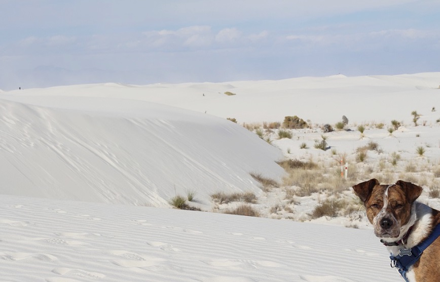
On Thanksgiving Day, Gunther and Nancy and I went to White Sands National Park. It’s near the town of Alamogordo (Spanish for “fat cottonwood”), New Mexico, where we camping for a week. We were a bit surprised at the number of people who’d also chosen to visit the park on Thanksgiving, but, judging from the languages and accents we heard, we think a lot of them were tourists from Japan.
White Sands was first declared a national monument in 1933 and was re-designated as a national park in 2019. Nancy and I visited the then-monument during a trek through New Mexico in 2015, but were happy to share the experience again with Gunther. White Sands is the most-visited of the two national parks in New Mexico; a typical year sees 600,000 people stroll, slide, stumble, and tumble down its dunes. During the last two years, the pandemic increased that visitation to more than 700,000 visitors annually. (Carlsbad Caverns National Park, the state’s other national park, receives about 440,000 visitors each year. Two of those were Nancy and me; more to come on that.)
White Sands National Park is on the northern edge of the Chihuahuan Desert, which encompasses about 175,000 square miles. This desert, the largest in North America, stretches 1,200 miles from Alamogordo southward well into Mexico.
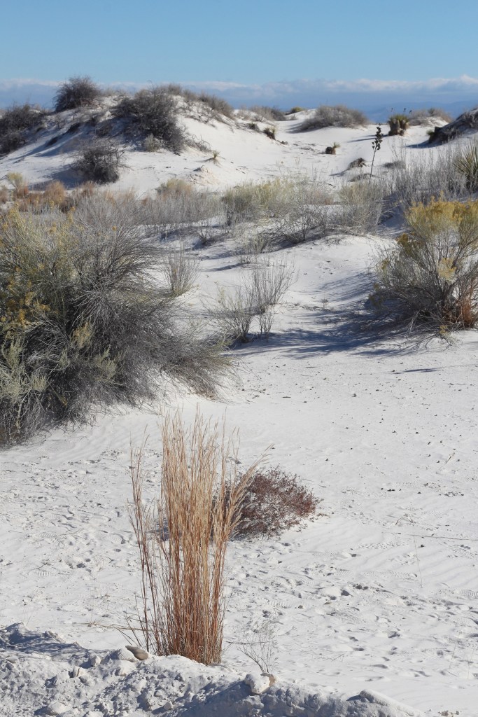
We took a walk on the park’s Interdune Boardwalk, which provides a lot of introductory information about the park’s ecosystems, and then hiked a two-mile loop in the dunes themselves along a marked trail where backcountry camping is permitted. There’s not a path in the dunes; the wind would scour away any trail in the sand within a couple of days. Instead, the route is marked with tall posts.
That’s a grass known as little bluestem (Schizachyrium scoparium) in the foreground. Little bluestem is very common throughout the Great Plains and the intermountain west, and can survive in the desert here at White Sands National Park because the water table is typically only two or three feet below the surface. While on our hike, we noticed that the sand between the dunes was actually pretty wet. The Tularosa Basin, which includes the town of Alamogordo as well as the national park and White Sands Missile Range, is bordered by the Sacramento Mountains on the east (in the background of this photo) and by the San Andres and Oscuro mountain ranges on the west. The Tularosa Basin is about one-third larger than the state of Connecticut.
Some more rather staggering numbers regarding White Sands National Park: the sand has an average depth of about 30 feet, some of the dunes are 60 feet high, and the scientists figure that the dunefield contains about 4.5 billion tons of sand.
This photo, taken from the passenger seat of the Goddard’s six-wheeled towing unit, shows not snow, but sand. White Sands National Park features the largest gypsum dunefield in the world: at 275 square miles, it’s so big that it can be seen from space. (Great Sand Dunes National Park in southern Colorado measures about 30 square miles and contains several different minerals.) Only about 40 percent of the White Sands dunefield is in the national park; the rest is in the U.S. Army’s White Sands Missile Range (WSMR), which surrounds the park, and is strictly off-limits to the public. WSMR has an area of 3,200 square miles and is the largest military installation in the United States (it’s 32% bigger than Kit Carson County in eastern Colorado). The national park is occasionally closed to visitors because of missile testing on the range. The world’s first atomic bomb, Trinity, was detonated on the northern edge of the missile range on July 16, 1945, as a test prior to the United States releasing atomic bombs in Japan to bring World War II to an end.
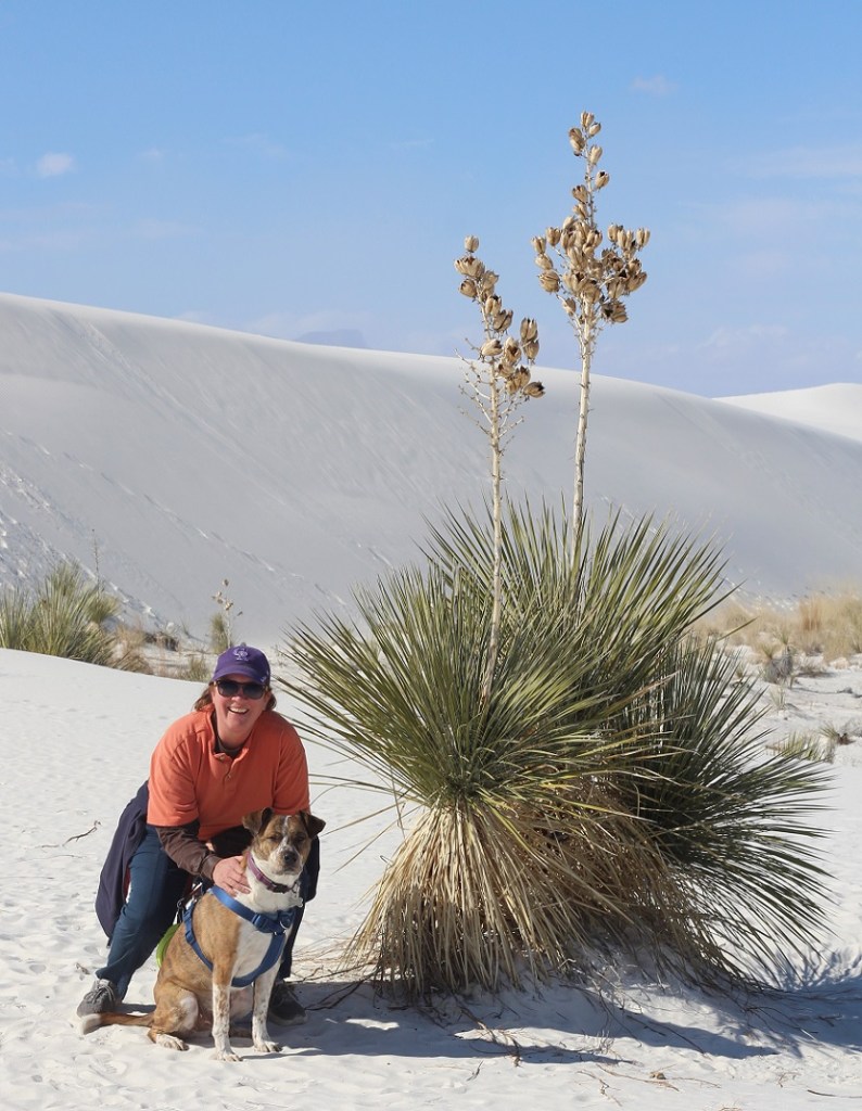
Here we see a visitor to White Sands National Park and her ill-behaved dog (it’s Nancy and Gunther) on the Interdune Boardwalk, a short elevated trail with many exhibits along the way. A good variety of desert plants, including shrubs, grasses, and cacti and succulents, thrive in some parts of the dunes.
The sand is remarkably white, and remarkably fine – most of the grains are smaller than crystals of table salt or sugar. Where did all of the sand come from? The answer lies, as many do, with the fact that this part of the planet was covered by a vast inland sea during the Permian Period (about 300-250 million years ago). The waters eventually evaporated away and left immense deposits of gypsum (also known as the mineral calcium sulfate) in the former seabed. Tectonic activity then uplifted the mountain ranges on either side of today’s Tularosa Basin. Over tens of millions of years, rain slowly dissolved the gypsum deposits in the mountains and ancient rivers carried the minerals to today’s White Sands National Park. The dunefield is relatively new, geologically speaking: it’s only 10,000 years old.
Gypsum has a number of beneficial uses for humans: it’s the prime component of drywall, which is used in building construction, plaster of Paris, and toothpaste. It’s also found in all kinds of food, including canned vegetables, white flour, ice cream, and in the production of both beer and wine; people ingest almost 30 pounds of gypsum during their lifetimes.
The mineral’s usefulness led to the designation of White Sands as a national monument in order to protect the area, and its plants and animal ecosystems, from commercial development.
Soaptree yucca (Yucca elata) is a really interesting desert succulent. Native Americans had more than 100 uses for the plant, including as a source of food, fibers for the manufacture of textiles, and true to its name, soap. The stem of the soaptree yucca, which grows underneath the sand, can be many times longer than the height of the plant above ground. As sand moves and threatens to cover the plant, the soaptree yucca continues to elongate its stem so that the plant’s photosynthesizing leaves stay above ground.
The seed pods of soaptree yucca (shown here in their dried form at the end of November) had many uses for Native Americans, and they’re also important to the desert ecosystem. The park is home to 800 different animal species, 650 of which are moths. Thirty-five of the moth species are found only at White Sands. Several different types of moths are responsible for pollinating the soaptree yucca, and they also lay their eggs in the flower pods.
One thing the scientists don’t know is why Gunther enjoys running on the sand so much. He did this at Great Sand Dunes National Park in Colorado, and he’s done it on beaches at reservoirs and lakes. He’s kind of a nut.
The wind carves the sand on the dunes into all kinds of interesting patterns of ripples, shifting nearly imperceptibly but constantly with every gust. I included the footprint in this crop of the photo to provide some scale; who knows who left it, and how many thousands of years has it been imprinted in the sand? (I left it, about five seconds before taking this photo.)
Here was a fun little surprise: I wasn’t expecting to find rubber rabbitbrush (Ericameria nauseosus) in the desert sand, but here it is. We planted several of these at our home in Denver, and they were hosts to hundreds and hundreds of bees, along with lots of butterflies, during their late summer blooms. Rabbitbrush’s pollen is important source of food for butterflies during their migration. Native Americans used the yellow pollen to dye textiles, and they used other parts of the plants to make baskets and arrow shafts.
We saw a few invertebrate species of animals, including some beetles, but we didn’t see any mammals during our hike in the dunes. The park is home to American badgers, coyotes, black-tailed jackrabbits, desert cottontails, bobcats, and several different rodents. Most of the larger animals beat the heat by being nocturnal: staying in their burrows until nightfall. I think some kind of bird left the tracks on the left, and I’m fairly certain the photo on the right shows tracks from a northern Chihuahuan desert wolf. (I’m just kidding with you right now; they’re Gunther’s.)
The northern Chihuahuan desert wolf Gunther stopped running around long enough for me to take this picture on our two-mile hike on the dunes. The lower areas between the dunes provide a sheltered and well-watered place for plants to grow. The black dot at the top of the dune on the left side of the photo is another hiker.
White Sands National Park is an incredible treasure. A short hike up a 60-foot sand dune rewards one with a wonderful view of mountains, sky, and … more sand dunes. Nancy and I wondered, while on the two-mile hike, what it would be like to camp on the dunes. It would probably be an eerie experience — quiet except for the wind and occasional coyote yip. The stars would be beyond beautiful at night, though – something to consider for another trip to the park.
It’s bold to call a town theBarbed Wire Capital of the WorldTM, but that is indeed what La Crosse, Kansas does. The designation came about because of another of La Crosse’s claims to fame: it’s the home of the Post Rock Museum. But before we get into post rocks, let’s go back to barbed wire (if you really want to read about post rocks, scroll down to the bottom of this post but you’re going to miss out on the truly exciting barbed wire content). In the early 1960s, volunteers at the Post Rock Museum noticed that a large number of visitors took special notice of the small barbed wire exhibit.
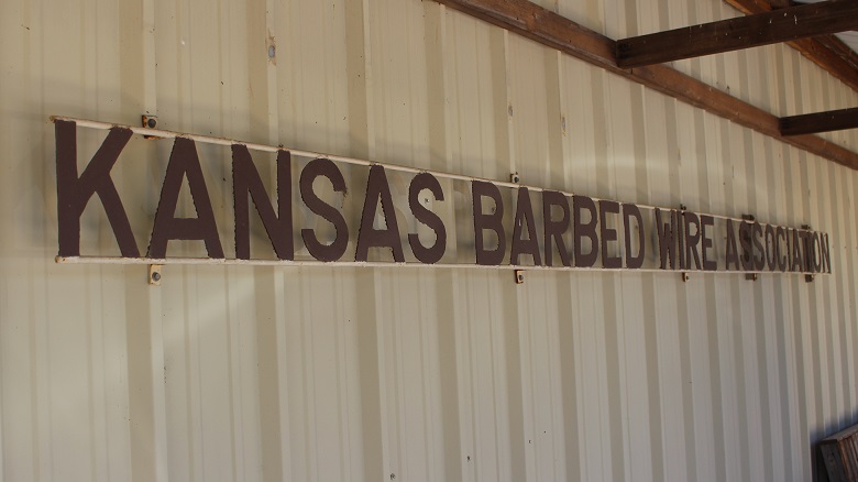
La Crosse, Kansas (founded 1876, current population of 1,266 people), is the Barbed Wire Capital of the WorldTM and is home to the Kansas Barbed Wire Museum and the Post Rock Museum (note the structures holding up this sign; read on for more information on those).
In response to that interest, in 1966 a group of La Crosse businesspeople formed the Kansas Barbed Wire Collectors Association. As with any association, it conducted an annual event: the first Barbed Wire Swap and Sell Convention occurred at the Rush County Fairgrounds in May of the following year. More than 2,000 barbed wire collectors and enthusiasts attended the show. La Crosse has since hosted the event each year (the 2022 festival was May 5-7) and that’s one way you get to be called the Barbed Wire Capital of the WorldTM.
This signage is posted prominently on the museum’s exterior. I’ve spent most of my professional career working for nonprofit associations, and I’m still continually surprised at the truth of the statement, “There’s an association for everything.”
Another way is to develop a museum. The first building that housed the Kansas Barbed Wire Collectors Association’s collection of barbed wire and associated materials was a small structure on Main Street in La Crosse. The museum was dedicated on April 30, 1971; the day included a parade as well as appearances and remarks from various local and state dignitaries. The 500-square-foot building was home to displays of 500 types of barbed wire, tools, and other artifacts, the majority of which came from the collections of two Kansas men, Leo Schugart of Hoisington and Don Wigington of Quinter.
If you’re researching barbed wire, sooner or later you’ll be making your way to La Crosse, Kansas. If you’re hungry after studying barbed wire, be sure to visit the JCT 4 Diner, located on the north end of town (the museum is on the south end) and order the chicken-fried steak. Come to think of it, I wonder if there’s a chicken-fried steak museum.
Alas, less than two decades passed before the museum had outgrown the Main Street building. The La Cross chamber of commerce commenced a fundraising campaign to construct a new building, measuring 5,400 square feet, in the town’s Grass Park. The new facility, built in a year, was dedicated on May 4, 1991. The Kansas Barbed Wire Museum, which is owned and operated by the Kansas Barbed Wire Collectors Association, is also home to the Antique Barbed Wire Society’s Historical Research Center as well as its Hall of Fame. The museum welcomes visitors from around the globe each year.
Two of those visitors this year were Nancy and me, in late May. Nancy, recognizing my enthusiasm for barbed wire exhibits during our travels (we’ve seen an impressive number of exhibits in city museums in New Mexico and Arizona), surprised me with an early birthday gift of a visit to the museum. At the time, we were camping in Hays, Kansas, which is located about 25 miles due north of La Crosse. For those unclear or simply unaware of where Hays is, it’s about 160 miles east of the eastern border with Colorado, conveniently located in the north-central part of Kansas on Interstate 70.
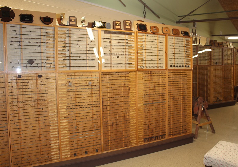
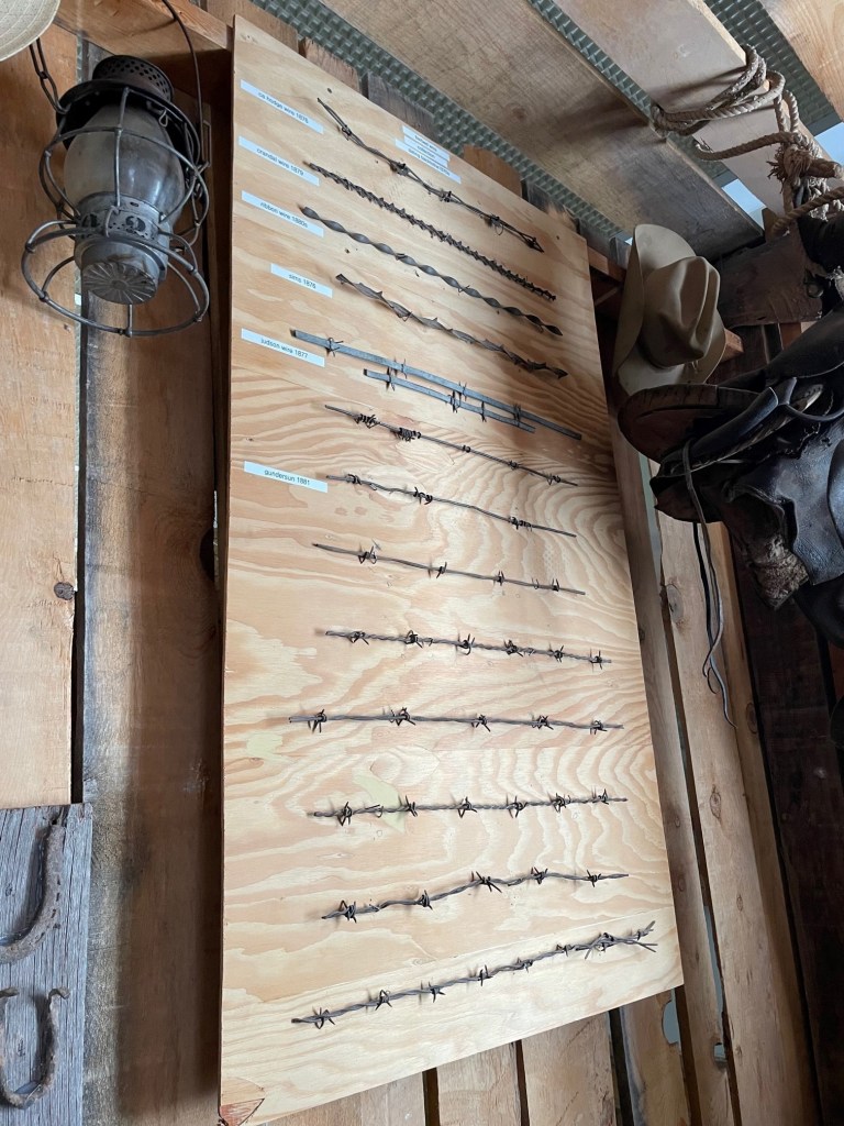
The biggest part of the Kansas Barbed Wire Museum is its immense collection of barbed wire varieties, displayed in case behind Plexiglass. (Forgive the glare from the overhead lighting in this photo, but the Plexiglass is probably what you want between barbed wire and you.) I neglected to count, but I would imagine there are a couple of dozen cases (I’m not kidding) like this one. The museum’s collection contains more than 2,400 varieties of barbed wire mostly from the American West of the late 19th century, but also contemporary styles and those from around the world.
You might be asking yourself: “Why is there a museum dedicated to barbed wire?” It’s a fair question, I suppose, and for the answer we must go back to the formation of the North American continent and its place on the earth. Imagine a vertical line hugging the eastern borders of North and South Dakota, continuing south near the eastern border of Nebraska, and then across the eastern thirds of Kansas, Oklahoma, and Texas. That line is the 98th Meridian, meaning that it’s 98 degrees (out of the globe’s 360 degrees) west of the Prime Meridian at Greenwich, England (all meridian lines extend north and south to the poles of the earth). The 98th Meridian is significant because most all of the land in the United States west of that line (with the exception of the Pacific northwest and the west coast) gets less (and some get much less) than about 20 inches of precipitation each year, and everywhere east of that line receives more than 20 inches. To compare five cities in which we’ve recently been:
City
Meridian
Annual inches of precipitation
Tucson, Arizona
111th
10.6
Denver, Colorado
105th
14.3
Hays, Kansas
99th (one degree west of the 98th)
23.8 (plus an additional 13.9 inches of snow)
Memphis, Tennessee
90th
53.7
Detroit, Michigan
83rd
34 (plus an additional 33 inches of snow)
There are altitude-based and other geographic exceptions to the annual precipitation amounts, of course: a mountain town in Colorado such as Ouray, in the San Juans, can receive 20 or 24 inches of rain and almost 12 feet of snow each year. The point is, there are some places in the United States that are better suited to growing moisture-dependent crops such as, say, corn than others.
In the last year of being on the road, Nancy and I have experienced single-event rainstorms in Arkansas and Indiana that would have provided a third of Denver’s annual precipitation. That arid nature of the western United States results in different types of flora (such as buffalograss and saguaro cacti) and fauna (such as desert bighorn sheep and horned lizards), and, to get back to the subject of barbed wire, much fewer trees.
East of the 98th Meridian, trees are pretty common thanks to the arable soils and relatively high levels of precipitation. Because of their ready availability, trees provide wood with which to build fences to contain livestock and protect crops. However, in the high plains of the west, most trees grow naturally only along waterways like year-round rivers or seasonal creek beds; many of those trees, like cottonwoods and mesquite, are not anything with which you’d want to build a house or even construct a livestock fence.
Each of the mounted varieties of barbed wire is accompanied by signage denoting the name of the variety (Ox Pen Wire, Vosburgh Cast Iron Plate, and Scutt’s Early Clip, among others here), along with the U.S. patent number and date of patent, as well as the museum’s unique collection identification number. There are, again, 2,400 varieties of barbed wire on display at the museum, as well as vintage examples of all of the tools used to build and maintain the fencing. Certain people take this sort of thing very seriously, and I’m glad that they do. We all have our personal hobbies and interests, right?
While it doesn’t support any real kind of tree growth, the Great Plains does have a great variety of other plants. The native grasses of the prairies west of the 98th Meridian developed deep-growing roots in order to reach reserves of moisture in the soil. In addition to keeping the soil from blowing away during wind events, the grasses wouldn’t turn over easily with farm implements developed for eastern croplands. Further, those native plants had evolved to need much less moisture to survive than did crops such as wheat and especially corn that grew readily in the eastern United States.
The museum has a cabinet devoted to barbed wire with historical significance, which I found very interesting. Many of this blog’s readers with Kansas roots will remember the tornado that nearly completely destroyed the town of Greensburg, Kansas, on May 4, 2007. One can read the history of this artifact on the signage below the artifact. Greensburg is about 70 miles due south of La Crosse.
Some of the earliest expeditions by the U.S. Army into what is known today as the Great Plains showed that the land probably wasn’t fit for much at all. In an 1810 journal recounting his adventures in the U.S. West, First Lieutenant Zebulon Pike wrote “these vast plains of the western hemisphere may become in time (as) equally celebrated as the sandy deserts of Africa.” Major Stephen H. Long, who traveled more than 26,000 miles in five expeditions across the West, in 1820 called the area “a great desert,” which later led to the term “the Great American Desert.” The plains area from present-day Nebraska south to Oklahoma was, according to Long, “unfit for cultivation and of course uninhabitable by a people dependent on agriculture.”
This display, mounted high in the rafters of the museum, was one of the exhibits in the museum’s first building and brought to the new facility. It is a nest built by crows almost entirely of wire, much of which is of the barbed variety. The nest was found in Greeley County, Kansas, which is along the border with Colorado in the far west part of the state. In the exhibit, the wires are real; the crows are not but they give a sense of scale to the 72-pound display. Nests like these are found in the arms of utility poles and on windmill towers.
The passage of time shows that both Zebulon Pike and Stephen Long were wrong* about the prospects of people living in the High Plains. However, it took unimaginable hard labor, perseverance, and technological breakthroughs, in addition to that passage of time, to prove them incorrect. In 1820, the entire United States had a population of less than 10 million. Today, more than 14.5 million people live in the states of Nebraska, Kansas, Oklahoma, and Colorado. The Front Range of Colorado, which stretches from Pueblo in the south to Fort Collins in the north, has a population of more than 5 million people alone [and the Front Range also has views of two of Colorado’s most prominent mountains, Pikes Peak (elev. 14,115 feet) and Longs Peak (elev. 14,259 feet); I don’t know why the names don’t have possessive apostrophes, but these namesakes show that you can get mountains named after you even if you’re wrong].
*Actually, I don’t know that Pike and Long were entirely wrong. At least along the Front Range, that population of 5 million people is largely possible only by water being brought from somewhere else: snow runoff in western Colorado rivers that’s diverted under the Continental Divide to the Front Range, and water being pulled from the underground Denver Basin aquifer through wells. States downstream from Colorado are making increased (and, to this point, entirely legal) demands for Colorado’s western slope water, and the Denver Basin took tens of thousands of years to fill but is now being further depleted every year. Many farms in eastern Colorado and western Kansas and other parts of the area irrigate their corn (the crop doesn’t have much of a chance of success in the Great Plains without irrigation) with a lot of water pulled from the Ogallala Aquifer, which is being similarly and rapidly depleted, without a possibility of being refilled on a human timescale.
But I digress. Back to barbed wire. The 98th Meridian, then, served as a kind of barrier to westward expansion of the United States during and after the U.S. Civil War. The native grasslands were too tough to efficiently plow for use as cropland, and there was no guarantee that there would be enough precipitation to help crops survive even if their seeds could be planted. Add to that the fact that there was very little lumber for building or burning, and it was a land most inhospitable for development.
I haven’t played chess in quite a long while, but I still found this chessboard and piece display a lot of fun. Each type of piece is made from a different variety of barbed wire, identified by a nearby placard (ex., the two kings are made from Wing Staple Barb, patented in 1878; the four knights are Merrill’s “Twirl,” patented in 1874; the 16 pawns are made from Glidden’s “Oval,” patented in 1876).
What was the land, which supported at the time only a number of nomadic Native American tribes that hunted immense herds of bison and other native animals, good for? Well, some folks decided it could support cattle. Between 1866 (the year after the Civil War ended) and 1880, nearly 5 million head of cattle were driven from Texas north into Kansas and beyond for transport by railcars back east.
Barbed wire is also very effective at limiting the movement of people. This section of wire, along with the fragments of concrete, was taken from the Berlin Wall after that structure fell due to extraordinary social revolutions in late-1980s eastern Europe. The wall, for which construction began in 1961, separated the countries of East Germany and West Germany for nearly 30 years, until November 30, 1989. The museum devotes a lot of display space to exhibits of other barbed wire used for human containment, such as concertina wire, providing welcome food for thought beyond the wire’s use for livestock and crop fencing.
Along the way, some cattle were sold to ranchers in Texas, as well as present-day Oklahoma, Kansas, and other states. Those cattle helped establish ranches that, in a few cases, are still around today. The Homestead Act, signed into law in 1862, brought droves of people to the west with the intent of acquiring free land upon which they could build homes and develop farms. Moreover, the railroads, in addition to transporting cattle east, brought more people from the eastern United States to the west where public sentiment thought it increasingly likely that livings, if not fortunes, could be made – despite the treeless aspect of the plains.
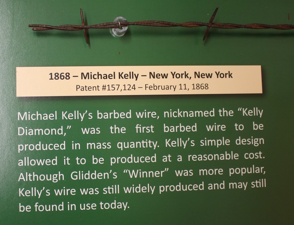
Those eastern sentiments, such as putting up fences to protect their crops and livestock, conflicted with the open range rights that the cattlemen enjoyed. However, the plains still weren’t any good at providing trees with which one could make fences. Until farmers could cost-effectively keep free-range cattle from tromping their crops and their own livestock from wandering away into the vast expanse of the plains, there was no way for livings to be made. That changed on November 24, 1874, when Joseph Glidden was awarded a patent for barbed wire.
Glidden (January 18, 1813 – October 9, 1906) was an Illinois farmer (I’m writing this blog posting at Kankakee River State Park in Illinois, about 90 miles southeast of Glidden’s farmstead in DeKalb) who developed one of the first methods of mass-producing barbed wire using a coffee mill to create the preliminary experimental barbs. With another twisted wire keeping the barbs in place, Glidden developed “The Winner,” which he considered his best design effort and for which he received the U.S. patent. The development was an immediate success and quickly found its way west, where, since much less wood was needed to build fences, it ended the open range era of the American west and it turned the Great Plains into innumerable pastures. When he died in 1906, Glidden was one of the richest men in America.
Today, drive along any road – multi-lane paved Interstate highway or dusty gravel byway – in the West and you’ll likely see galvanized steel barbed wire fencing that can stretch for miles on into the horizon. It’s cheap, durable, and relatively simple to install, without the use of much wood (except where there isn’t any wood; see below).
Joseph Glidden may get the majority of the praise for popularizing barbed wire, but there were others before and after him who produced it.
Glidden’s “The Winner” wasn’t the only barbed wire design, and many before and many after him developed their own styles that they thought would work better in certain situations or environments. Those hundreds of other barbed wire designs, all with the intent of keeping animals in (or out) of a certain area, kept and continue to help keep Americans and the world fed and clothed for generations – and that’s the reason there’s a Kansas Barbed Wire Museum.
What to Do When There’s No Wood
Prior to the coming of the railroads to the west in the late 19th century, vast tracts of lands in the west couldn’t be fenced because there were no trees with which to provide wooden posts and rails. Even after the continent was crossed and after barbed wire was easily available, wood was still scarce and therefore best reserved for building living and work structures.
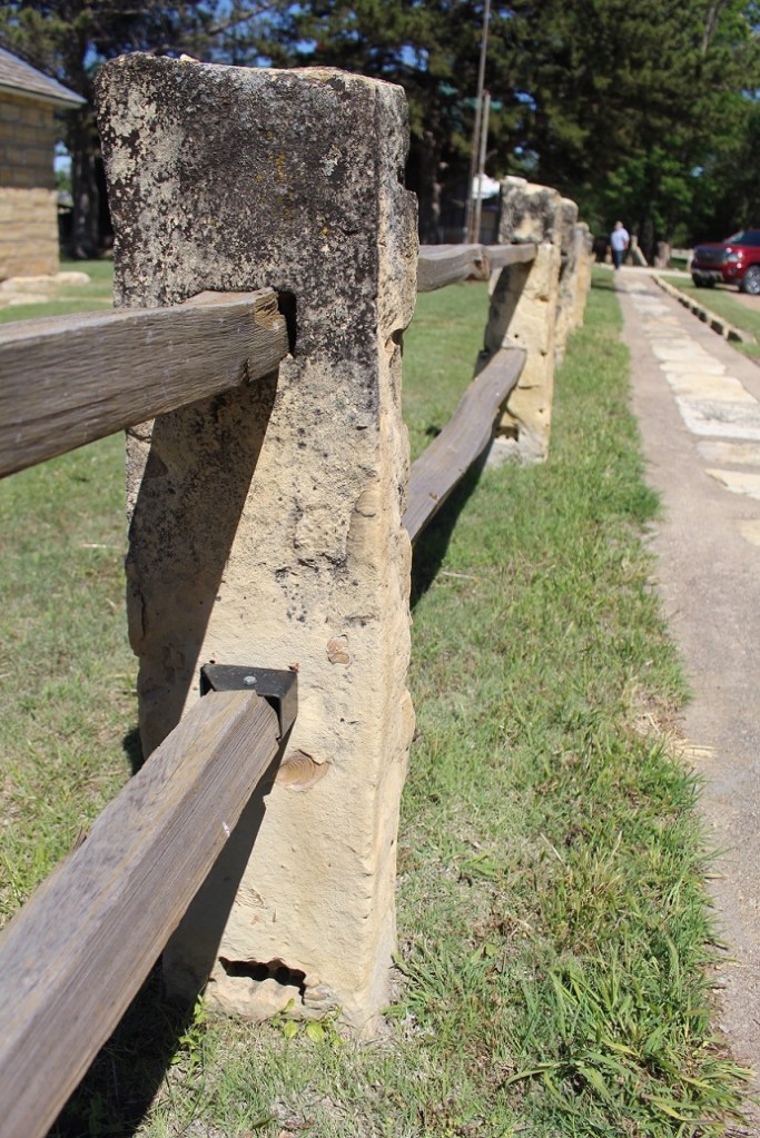
But spools of barbed wire can’t be used to build a fence without some sort of solid material used for a post, so what do you do? In the case of central Kansas, you use readily available material: rocks. Present-day Kansas, like much of the rest of America, was once under a great inland sea. Over millions of years, organic material from recently departed marine creatures fell to the sea bottom, and over further millions of years was compacted into a rock called limestone.
La Crosse’s original claim to fame was the Post Rock Museum, inside which are exhibits detailing the techniques and tools used to extract limestone used for fenceposts and other construction needs (such as for the Post Rock Museum itself and many other buildings in the area). The Post Rock Museum now shares the limelight with the Kansas Barbed Wire Museum; happily, the two are about 20 feet apart from each other.
The inland sea eventually drained away and, millions of years later, left present-day Kansas relatively dry and treeless under buffalograss-covered topsoil. Needing materials which which to build fenceposts, early settlers resorted to extracting the limestone rocks from just under the area’s topsoil. The area in which the limestone rests covers a 200-mile-long swath of Kansas land stretching southwest from the north-central border with Nebraska to about the location of Dodge City (a town, like many others in Kansas, that was made possible by the cattle trails of the late 19th century) in the southern part of the state. The swath measures in width from 10 to 60 miles wide. Farmers and people who specialized in quarrying post rocks would spend a day extracting about 25 posts, each of which could weigh between 200 and 450 pounds, from the ground.
This example of a post rock fence is adjacent to the Post Rock Museum, which originally had a relatively small display of barbed wire artifacts in addition to its primary focus of exhibits about extracting the posts from the ground. The popularity of the barbed wire display led to the establishment of the Kansas Barbed Wire Museum, now located directly next to the Post Rock Museum. See also the photos of post rocks used in the sign supports for the Kansas Barbed Wire Museum and the Antique Barbed Wire Society’s Historical Research Center at the top of this post – kind of brings it full-circle, don’t you think?
Because of their strength and stability, post rocks were needed only every 30 feet or so to support a barbed wire fence. Today, with the ready availability of steel and treated wood posts, post rocks aren’t nearly as high in demand. But in their heyday, from the mid 1880s to 1920s, post rocks were found in 40,000 miles of fencing in that swath of central Kansas – and, because of their durability (they’re rocks), many are still in use.
Back to Barbed Wire
Barbed wire, at first glance, may not seem like a significant development. But without it, the expansion of Anglo-Europeans westward across the 98th Meridian would have been, at best, substantially delayed. Beyond the economics and geographic expansion, barbed wire had huge cultural impacts as well: because it disrupted the migration of bison herds, barbed wire also led to the displacement of dozens of Native American tribes that had considered the region their homeland for many generations. Barbed wire, with a solid assist from the railroads, is what made the Anglo-European development of the Great Plains possible.
St. Vrain State Park had its beginnings in 1958 when the Colorado Department of Transportation bought some land around St. Vrain Creek to mine gravel needed for the construction of highways in the area. The mining projects left wide but relatively shallow holes in the ground, many of which filled in from the low water table of the St. Vrain. Over the years, more mining companies extracted more gravel, and now St. Vrain State Park has eight ponds and reservoirs, along with 87 campsites in eight different campgrounds. The state park is a popular destination for campers along Colorado’s Front Range; it’s just an hour’s drive from our former house in Denver. We camped there in our former trailer every April for a decade before becoming full-time RVers, and we returned to the shores of St. Vrain State Park in early May 2022.
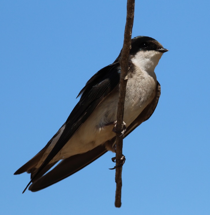
St. Vrain State Park is a bird enthusiast’s dream destination. The park’s literature lists more than 200 bird species that can be seen in the park’s ponds, wetlands and meadows. Not all of those species are in the park at once; many use the ponds as a migratory rest area on their way to points north or south of Colorado, and others stay in the park for a few weeks or months out of the year. We saw more American white pelicans in the park in 2022 than we had in previous years. Watching them float noiselessly on the surface of the water is a very relaxing experience. When we were camping along the west bank of the Mississippi River in Arkansas a few weeks later, a flock of about 200 pelicans darkened the sky as the birds flew overhead.St. Vrain State Park is the largest great blue heron rookery in Colorado. Great blue herons are relatively common sights along the banks of the larger ponds in the park; they usually fly off if approached. If one is patiently quiet and still, however, it’s possible to see a heron catch a fish in the shallows. The largest of the heron family, great blue herons can grow to 4 1/2 feet tall and weigh more than five pounds, with a wingspan of 6 1/2 feet. I photographed this one on an early foggy morning on the bank of Sandpiper Pond. Whenever I think of St. Vrain State Park, the first bird that comes to mind is the red-winged blackbird. Their distinctive call (you can hear it at the soundfile below) can be heard throughout the park practically all day long, but especially in the early morning hours. While I’ve seen red-winged blackbirds perch on waving reeds and cattail stalks, in addition to tree limbs, this one found a solid fencepost upon which to belt out the hits. This is a bird species in which the males and females look nothing alike. This is a male blackbird; I’ve mistaken female blackbirds for some type of sparrow because they share the same light and dark brown markings.We were happy that our friends Mary and Robert, and their German shepherd, Otis, could camp at the site next to us on one of the weekends we were at the park. Mary, Robert, Otis and I took a walk one morning around Blue Heron Reservoir, the largest and newest of the lakes at the park, and happened to spot this guy out in the water. This photo of a western grebe isn’t great – it was 50 yards out and drifting further away – but it’s an interesting bird. They dive underwater to catch fish, which is their main diet, and it’s kind of fun to guess where they’ll pop up to surface. One of five grebe species that visits St. Vrain State Park, I’d also seen this species at Lathrop State Park near Walsenburg in October 2021.This well-camouflaged little bird is a song sparrow (I’m pretty sure; there are many varieties of sparrows and most of them look at least a little alike). It was hunting for bugs one evening along the banks of Mallard Pond. Click the link below to see why they got their name.Nancy and Gunther and I went on a longer hike one Saturday morning and saw a pair of tree swallows feeding their young nestlings inside a tree cavity. This is the female of the pair, who was hanging out on a tree limb and watching her mate feed their kids in the tree. She’s got just a hint of iridescent blue coloring on her head, whereas the male tree swallow is mostly blue. Like other swallows, their diet is mostly bugs that they catch while flying in the air; unlike other swallows, they also eat berries which allows them to make it through winter much easier.I took this photo of a female brown-headed cowbird a few minutes’ walk down the trail from the swallows’ nest. Cowbirds used to follow bison herds in the American West and forage on insects that were kicked up by the animals’ hooves. These days, they do the same with cattle herds and they’re found from coast to coast. This species has a fairly poor reputation among bird enthusiasts: it doesn’t build a nest in which to lay its eggs but instead lays its eggs in the nests of other bird species. This parasitism, which is practiced by only a few other birds, results in reduced numbers of other songbird species. I’ll be the first to state that this is a terrible, terrible photo. However, there is a story behind it: a little while after taking the photo of the brown-headed cowbird, we looked up and saw what we thought was a flock of Canada geese flying overhead. I took a picture of part of the flock, and I really don’t know why. After our hike, I looked at the photo on my laptop’s screen and realized that those weren’t Canada geese. Look at the beaks of the birds (they’re flying toward the right side of the photo): they’re very long and slightly curved. I thought they might be ibis (ibises?), and I looked at the park’s literature to see if ibis were ever sighted in the park. Turns out white-faced ibis do indeed migrate through St. Vrain State Park! Here’s a link to an Audubon Society page so you can see what these beautiful birds really look like.I know some readers of this blog frequently drive on I-25 between the Denver metro area and the northern reaches of the state. This is what’s beneath the bridges just north of Exit 240: thousands upon thousands (not kidding) of cliff swallow nests (those brownish smudges are the cliff swallows returning to feed their nestlings; I couldn’t get any decent photos of the birds themselves because they move so fast). The swallows have built the nests here to take advantage of the great biomass (bugs) available at the ponds and lakes of St. Vrain State Park. It’s important, I think, to remember just what a huge service that bug-eating birds do for us: imagine how many more grasshoppers, caddisflies, and mosquitoes we’d have to deal with were it not for these feathered friends of ours. The hike that Nancy and Gunther and I went on was chock-full of nifty birds we hadn’t seen before. I had no idea what this was when I took the photo, but I could tell it wasn’t a seagull. Again, after returning to the Goddard, I looked it up. It’s a Forster’s tern (might be another species, the common tern, but Forster’s terns are, inexplicably, more common than common terns). This was an incredibly acrobatic and fast flyer, and much fun to watch during its migratory stopover at the park.I took this photo of a beautiful barn swallow on the same morning that I took the photo of the great blue heron. The lighting, because of the fog, wasn’t great, but I was happy to see this little fellow light for a few minutes on a stretch of fence. Swallows of all kinds are very aerobatic flyers – they dip and whirl about while chasing bugs over bodies of water. We would see yet another species of swallow, the northern rough-winged, while camping on the Mississippi River in mid-June. There are six species of swallows, including the northern rough-winged, that visit St. Vrain State Park either on a seasonal or migratory basis. Over the years I’ve probably taken a hundred photos of double-crested cormorants, but they’ve all been taken when the birds are too far away from shore to turn out very well. They seem to like the company of pelicans while swimming (or perhaps they’re opportunistic feeders taking advantage of the schools of fish found by pelicans), but they’re much more timid than the big white birds and stay further from shore. They also take flight well before the pelicans do. The stars aligned during our trip to St. Vrain State Park in May, and I finally got some photos that aren’t embarrassing to share. During our stop I also figured out why these birds look so odd while swimming: unlike pelicans, or ducks, or geese, or pretty much any other waterfowl, they keep most of their bodies submerged. I think cormorants are one of the greatest visual reminders that, in a way, dinosaurs still walk the earth. This guy would not look out of place as an extra in a Jurassic Park movie.I’ll close with one of the best photos I’ve taken in a good long while. St. Vrain State Park is home to several pairs of nesting ospreys, which return to the same nest year after year, and the number appears to be growing. I noticed a new osprey nest (really not that impressive; it looks like a pile of trash and twigs because that’s what it is) along the road leading into the park, and asked a ranger about it. Turns out that the nest had delayed construction of a section of a long-planned hiking and biking trail that winds its way along the I-25 corridor, at least until the osprey fledglings had left the nest. True enough, work on the trail appeared to recommence a few days before we left, so I guess the fledglings had left home. Anyway, this osprey pictured was perched above Mallard Pond one late afternoon when the sun happened to be shining for a few minutes during an otherwise overcast day. It’s obviously used to passersby, but it’s a beautiful raptor nonetheless. The ponds and lakes have plenty of fish for both anglers and birds, like pelicans, and terns, and grebes, and cormorants. It’s fun to watch a grebe pop out of the water with a fish in its beak, but watching an osprey slam into a lake, talons outstretched, and then lift away with a trout in its grasp is a fantastic experience.
In the two weeks we were at St. Vrain State Park, we saw 26 different species of birds, including five, like the tern and ibis, I’d never seen before at all. We don’t have immediate plans to return to the park, but I don’t doubt that we will go back sooner or later. It’s a great place to unwind, and, although it’s close to I-25, it provides plenty of opportunities to get to know a tremendous variety of our feathered friends.
The city of Colorado Springs is home to a number of U.S. military installations, including the U.S. Army’s Fort Carson; the U.S. Air Force’s Peterson Air Force Base, Schriever Air Force Base, and Air Force Academy; and the U.S. Space Force’s Cheyenne Mountain Station, Space Command, and Space Operations Command.
I spent some of my early years (1975-1979) growing up just south of Colorado Springs, and it was fun to be able to camp in the Goddard for a week in April a few miles from my childhood home. I’d forgotten how common it was to see people in military fatigues while walking around Colorado Springs: almost 10 percent of the population is active-duty military, and the defense industry is responsible for about 40% of the Pikes Peak region’s economy.
The U.S. military’s strong presence in Colorado Springs makes the city a fine host for the National Museum of World War II Aviation, which opened in 2012. The museum has a collection of 28 aircraft dating from the 1920s through just after World War II, and here’s what makes this collection unique: each of them still flies. Nancy and I have been to plenty of aircraft museums to see hundreds of aircraft, but this was the first one in which all of the aircraft could be taxied to a runway and take off. The airplanes are used in a number of airshows across the country, and therefore must be maintained to be reliable and safe in the air.
The non-profit museum is co-located at the Colorado Springs Airport with a private business called WestPac, which specializes in restoring and maintaining vintage aircraft. Our tour of the museum on April 29, 2022, also included a good look at what WestPac does to restore these beautiful birds and keep them in the air.
North American Aviation T-6 Texan
This T-6 Texan is one of 15,495 of the aircraft built by North American Aviation between 1935 and 1951. The Texan was used as a training aircraft for pilots of the U.S. Army Air Force (which later became the U.S. Air Force) and the U.S. Navy, as well as air forces of the British Commonwealth, during the World War II era and into the 1970s. The T-6, with a cockpit built for the flight instructor and student, has a maximum speed of 208 mph and a range of 730 miles. Because of the number still capable of flight, the Texan makes frequent appearances at modern-day airshows. That’s Pikes Peak (elev. 14,115 feet), which had received some new snow up top a day or two before this photo in late April, above the cockpit.
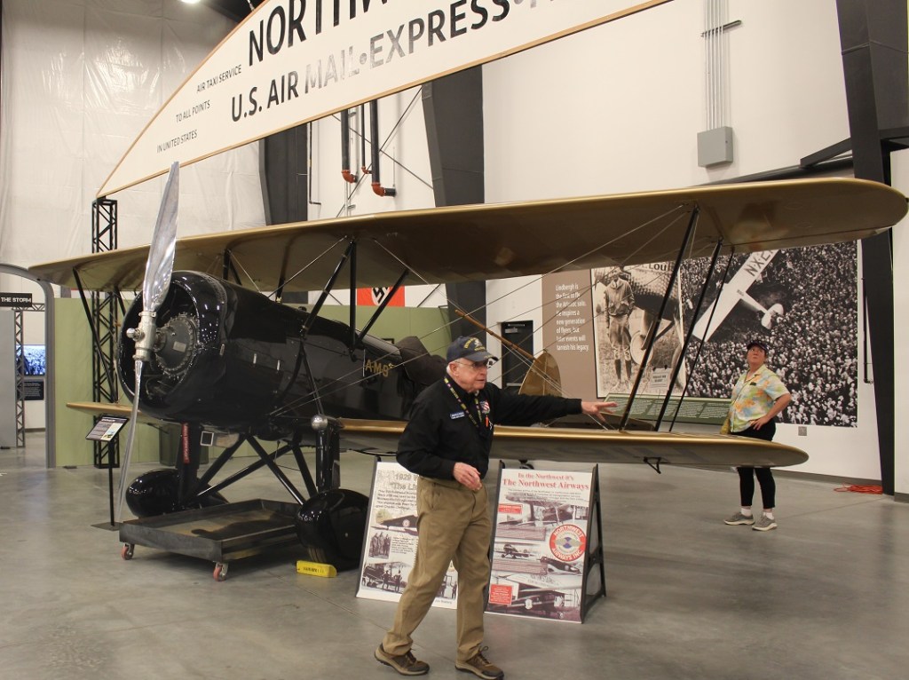
Waco JYM
That’s our guide for the tour, docent John Lynch, in front of a 1929 Waco JYM airplane. This particular aircraft is known as “The Lindbergh Plane” because Charles Lindbergh, who in May 1927 became the first person to fly solo across the Atlantic Ocean, later flew this airplane to help promote the new industry of airmail service (which had employed Lindbergh before his historic flight). The airplane pictured provided airmail and air taxi service on the nearly 900-mile-long route between Chicago and Minneapolis.
The Waco JYM doesn’t have anything to do directly with World War II but as is the case with all aircraft, its service record helped develop the technology used in later airplanes. The museum is right to be proud of having this airplane in its collection: it’s one of four Waco JYMs produced for Northwest Airways, and this 93-year-old aircraft is the only one still capable of flight (note the pan underneath the engine to catch oil – all of the aircraft in the museum’s collection have those). Mr. Lynch, a U.S. Navy veteran of the Vietnam War, provided a thoroughly educational and entertaining tour; he was able to speak not only about the mechanics required for powered flight from the viewpoint of an engineer, such as wing and propeller design, but also the global developments of World War II from a historical perspective. He’s one of the better docents Nancy and I have had the pleasure of meeting.
Douglas Aircraft Company SBD Dauntless
This is an SBD (for Scout Bomber Douglas – in U.S. Navy nomenclature of the day, the first two words of the acronym describe the function and the last word names the manufacturer) Dauntless; they were originally designed by Northrup but the model was further developed and then introduced by Douglas in 1937. The first flight was in 1940. The Dauntless was a light bomber and reconnaissance aircraft with a maximum speed of 255 mph and a range of 733 miles. It had two .50-caliber forward-facing machine guns and two .30-caliber rear-facing machine guns (which were operated by the gunner/radio and radar operator, who was kept plenty busy in the back of the cockpit). An SBD also carried up to an 2,250-pound bomb load. These were the primary U.S. Navy aircraft in service during the attack on Pearl Harbor in December 1941, and a Dauntless was the first airplane to sink an enemy ship in World War II (a Japanese submarine, three days after Pearl Harbor).
I don’t think Nancy nor I were prepared for how big these Navy planes were – I guess we’re just used to primarily seeing, in person at least, fighter aircraft that were used in the European theater of the war. An SPD-5 had a length of 33 feet, wingspan of 41.5 feet, and a height of 13.5 feet, all with an empty weight of 6,400 pounds. Interestingly, the Goddard, the fifth-wheel trailer in which we live, has a length of 35 feet and a height of just over 13 feet, but it has a dry weight of 14,000 pounds — it’s not expected to take to the air, though.
If you’ve seen either version of the movie “Midway” (the 1976 release with Charlton Heston or the 2019 edition starring a number of CGI pixels), the Dauntless is the airplane that gets the most screentime while showing the events of the battles of the Coral Sea and Midway. In the latter battle, these aircraft sank or disabled four Japanese aircraft carriers. Also serving in the Battle of Guadalcanal, the Dauntless was, despite its slow speed and relatively light armament, a very hardy and reliable dive bomber. These airplanes sank more enemy ships in the Pacific Ocean than any other World War II bomber. As aeronautic and armament technology increased rapidly during the war, the production of SBDs ceased in 1944.
It was a great experience to see an example of the aircraft that was able to so effectively counterattack the Japanese naval forces during the early weeks and months of the United States’ involvement in World War II. This particular aircraft has an interesting story: it crashed into Lake Michigan in May 1944, during aircraft carrier training exercises, and wasn’t extracted from the lake until the mid-1990s. It has since been restored to be a fully functional flyer, one of only six SBDs in the United States still capable of flight (one-tenth of one percent of the original total of 5,936 produced between 1940 and 1944).
Grumman TBM 3-E Avenger
An unidentified tour participant, who seems to be in a lot of these photos, lends a sense of scale to this TBM Avenger. With a gross weight of 15,500 pounds, this was the heaviest single-engine aircraft of World War II. Grumman built the first Avengers, which originally flew just a few months before the attack on Pearl Harbor in 1941. It was formally introduced in 1942, and Grumman would go on to build almost 2,300 TBFs (torpedo bomber, and the “F” was for “Grumman,” for reason that probably makes sense from a military perspective). Electing to stop building Avengers in 1943 so that it could focus on the production of fighter aircraft, Grumman awarded a contract to General Motors to continue building the torpedo bombers. GM would call its versions TBMs (“M” for “Motors”). In all, Grumman and GM built almost 10,000 Avengers for the U.S. Navy, Marine Corps, and Allied naval and air corps. Note the folding wings, which allowed for more of these aircraft to be carried by … aircraft carriers.
TBF Avengers were not an immediate success story: of six unescorted aircraft that participated in the Battle of Midway in early June 1942, five were shot down and the sixth returned with one crewman dead and the other injured. As the war progressed, however, crews gained invaluable experience (each aircraft had a pilot, a gunner/radio operator, and a bombardier) and the Avenger played a pivotal role in naval operations; the airplanes destroyed two Japanese super-battleships and sank dozens of Japanese submarines in the Pacific and German U-boats in the Atlantic. The TBF/TBM had a maximum speed of 200 mph, with a range of 1,000 miles. It carried one 2,000-pound torpedo or 2,500 pounds of bombs, in addition to three .50 caliber machine guns and one .30 caliber machine gun.
George H.W. Bush, who would later serve as a U.S. President from 1989 to 1993, was shot down by Japanese forces during a September 1944 bombing mission while flying an Avenger. He parachuted from the plane and was picked up offshore by an American submarine.
Lockheed P-38 Lightning
Here’s the first fighter aircraft we saw on the tour: the P-38 Lightning, which was the only truly successful twin-engine fighter seeing action in World War II. It was used primarily in the Pacific theater of the war, where big oceans and dense tree canopies made having redundant propulsion systems desirable. The Lightning was the first fighting aircraft in history to exceed 400 mph, and the only American fighter in production from the beginning of World War II until its end. The Lightning was armed with four .50-caliber machine guns, a .30-caliber machine gun, and four hardpoints for bombs or rockets. P-38s were credited with destroying 1,800 Japanese airplanes in the Pacific during the war. Lockheed made just over 10,000 P-38s during its production.
This particular P-38, like many of the other aircraft in the museum’s collection, has an interesting history – including the deepest combat history of any other airplanes in the museum. Pilot Ken Sparks, on a mission on the last day of 1942, was credited with two aerial victories while flying this airplane. He downed one craft with gunfire, and then inadvertently clipped another with the Lightning’s right wing. The wingtip lost several feet of material, but the aircraft survived while the Japanese craft crashed. Sparks would have 11 more victories in several additional aircraft. This airplane was buried for decades near an airfield in Papua New Guinea, and was restored by WestPac in 2017.
This is another very large airplane, especially for a fighter, which made getting a good photo difficult – it has a wingspan of 52 feet. Empty, it weighs 12,800 pounds – twice the weight of the Douglas SBD Dauntless.
Republic P-47D Razorback
This was an interesting exhibit, located just behind the P-38: it’s the hulk of a P-47D Razorback, which was found in roughly the same condition as the remains of the Lightning. WestPac has plans to restore it, which would likely make it the only flying Republic-built P-47D in the world. It, like the P-38, was buried in the jungle for more than 50 years and gives you an idea of what the WestPac restorers sometimes have to work with.
Republic P-47D Thunderbolt
This is the same model of aircraft as shown in the previous photo, but it has the later bubble canopy that improved the pilots’ abilities to see their surroundings. With eight .50-caliber guns totaling 3,400 rounds, P-47s were the most heavily armed Allied fighters of the war. They were also fully capable as bombers; a Thunderbolt could carry about half the bombing ordinance of a B-17 Flying Fortress. Thunderbolts had a top speed of 433 MPH and a range of 800 miles. About 15,500 P-47s were manufactured during the war years, and their versatility saw them perform in every theater of the conflict. As we were to discover at yet another aircraft museum in a few months, Thunderbolts were built primarily in Evansville, Indiana, in the southeastern corner of the state.
Douglas A-1E Skyraider
This airplane wasn’t discussed much on our tour, but it caught my eye for a couple of reasons: it’s painted in the livery of the South Vietnam Air Force, and it’s positively loaded for bear. The A-1E Skyraider was designed by Douglas during World War II as a aircraft-carrier-based single-seat replacement for the Curtiss Helldiver (see below) and the Grumman Avenger (see above). Prototypes first flew in March 1945, and Douglas Aircraft would go on to build 3,180 of these aircraft. Skyraiders saw a lot of action in both the Korean War and the Vietnam War. An A-1E had four 20mm cannons and up to a dozen rockets. Depending on the mission, a Skyraider – powered by a single Wright 2,800-hp engine – could carry bombing materiel equivalent to that of a four-engine B-17 or B-24: it was tested to carry 10,000 pounds of bombs. While Skyraiders were flown in aerial combat during the Vietnam War by the U.S. Air Force, the U.S. Navy, and the South Vietnamese Air Force – two of these aircraft shot down a Soviet MiG jetfighter – the primary mission of the aircraft was to provide air support for ground troops. It was the most accurate bomber of that conflict.
Grumman F3F-2
Our tour continued into the maintenance hanger of WestPac, which was a great experience. Compare this Grumman F3F-2 to the P-47 in a previous photo, and you’ll see how rapidly aeronautics advanced when there was a world war underway. The F3F-2, the last U.S. Navy and Marine biplane fighter, was introduced in 1936 and retired from service in 1941 – before the United States entered the war, and the same year that the P-47 entered service. The F3F-2 had a .30-caliber and a .50-caliber machine gun, but could carry only 700 total rounds of ammunition. It could also carry one 116-pound bomb under each of its lower wings. Its engine is a Wright Cyclone producing 950 horsepower (less than half that of the Thunderbolt’s Pratt & Whitney’s 2,000 hp), and it had a top speed of 264 miles per hour – a little better than half of the P-47’s top speed. It’s a beautiful airplane for its (or any) time, to be sure. but it’s also instructive to see how quickly technology can improve when the conditions couldn’t be more serious. We saw this particular model in WestPac’s service center being readied for its annual inspection so that it could once again take to the skies.
Curtiss SB2C Helldiver
Here’s an aircraft currently under restoration by WestPac, the Curtiss SB2C Helldiver-1A. These airplanes had a troubled beginning, as their heavy weight. as well as issues with control and stability, caused multiple delays after a prototype first flew in December 1940. Curtiss was heavily criticized by the U.S. government for failing to produce combat-ready Helldivers in the first four years after the placement of the order, but the first SB2Cs finally saw combat in November 1943 and performed admirably during the latter period of the conflict – replacing the Douglas Dauntless SBD. Helldivers carried four .50-caliber guns and one .30-caliber gun, in addition to a thousand-pound bomb. Eventually 7,140 of these aircraft were constructed. This particular airplane was used as a trainer and saw action for a short while after World War II. It was later sunk in a lake, but recovered in the 1980s and is now one of WestPac’s restoration projects. This is the Wright 2600-8 engine of the Helldiver (shown at top left in the preceding photo; the propeller has been removed). The engine produces 1,700 horsepower and takes the aircraft to a maximum speed of 295 MPH and a range of 1,165 miles. I think it shows just much work went into the design of all of these beautiful aircraft so that America could contribute to winning World War II. Moreover, it shows what must go into their ongoing maintenance to make sure that they still fly safely; when we owned a house, I felt proud of myself when I remembered to add oil to the lawnmower.
The National Museum of World War II Aviation is tremendously fascinating. Seeing a range of aircraft developed for both air combat as well as bombing was illuminating. It has fewer aircraft than most aviation museums we’ve seen, but the idea that all of the restored airplanes are still capable of flight really sets the museum’s collection apart. If you’re in the Colorado Springs area, the museum is well worth a visit – the aircraft there are really quite beautiful machines.
The Goddard spent the fall and winter of 2021-2022 in New Mexico and then Arizona, and in the spring we headed back north to visit Colorado for a while. Spring is a great time to watch birds: they’re very active as they gather material for nests and later find food for their fledglings. Leaves on trees also begin to emerge as the weather warms up, which I was to discover makes photographing birds much more difficult than in the fall and winter.
Here are some birds we saw doing their spring thing in Arizona, New Mexico, and Colorado.
Holbrook, Arizona
Our campground in Holbrook was next to a residential area, which doesn’t happen very often because usually campgrounds are on the outskirts of towns. It gave us a chance to walk by houses and see birds perched in the trees.
This female house finch was busy gathering materials for a nest at our campground in Hollbrook. Finches have really pretty songs, and they’re enjoyable to listen to in the morning. House finches are an interesting story: they’re native to the American southwest and Mexico, but profiteers captured some finches in the 1940s and attempted to sell them as “Hollywood finches” to bird enthusiasts in New York City. Rather than face prosecution for violating a federal law regarding migratory birds, the people released the finches into the wild and the birds established themselves on the U.S. east coast. In the ensuing years, they’ve moved both east (from the southwest) and west (from the east coast) to be found across nearly the entire country.Here is the mate of the house finch, watching the sunrise the same morning. I’m sure he later helped build the nest, too. The reddish coloration of male house finches changes with the seasons and is dependent on the birds’ diets; as you’ll see, some male house finches are redder than others. For their size, finches have some powerful beaks.This is a very common bird, the house sparrow, but it’s a very pretty one all the same. Mornings are a great time to take photographs of birds because the sun is low in the sky to provide dramatic lighting, and the birds themselves are fairly active.
Grants, New Mexico
The campground at which we stayed in Grants, New Mexico, at the end of March had an adjacent walking trail that wound through a lava field. A relatively recent volcanic eruption, perhaps only 4,000 to 5,000 years ago, produced the black basaltic rock that is everywhere around Grants. The campground’s trail attracted a lot of birds that perched on the trees and shrubs within the lava field, including this female white-crowned sparrow that was singing a pretty song one morning. It was the fifth species of sparrow I’d seen during our stays in New Mexico and Arizona. We really enjoyed this trail, which also provided great views of the surrounding mountains. A national monument, El Malpais (Spanish for “the badlands”) is very near Grants, and we look forward to visiting it in the future.Here’s the other male house finch I alluded to earlier. Dunno what he’s eating to get all of that red coloration, but he’s definitely the reddest finch I’ve ever seen. This was in the campground at Grants; I have a bunch of photos of different birds perched on different types of water valves at campgrounds, for some reason.
Albuquerque, New Mexico
Our next stop on our return north was Albuquerque, which Nancy and I really enjoy visiting. There’s a lot to see and do there, and plenty of great Mexican restaurants and grocery stores to enjoy.
We returned to Albuquerque’s excellent Botanic Garden at the city’s BioPark, which also has a zoo and aquarium situated along the Rio Grande near downtown. In early April the garden had thousands of blooming bulbs, including daffodils, tulips, crocus, and others, as well as a lot of neat birds. This is a male white-crowned sparrow; compare him to the pretty female white-crowned sparrow from the Grants lava field, two photos above. This guy was hunting for bugs on one of the garden’s trails.We watched this mountain bluebird bring a grub to its nest in a tree near the Botanic Garden’s farmstead exhibit. I really like the hue of blue, which contrasts nicely with their rusty chests, on these birds.Gunther and I went for a walk on a trail along the Rio Grande bosque one afternoon and I heard this fellow singing in a cottonwood tree. I couldn’t tell what kind of bird it was at the time because it was so far away, but I got a couple of photos with my telephoto lens. I was a little surprised to see, after looking at it on my laptop, that it’s a spotted towhee. I’d never seen one in a tree before; I’ve only seen them on the ground, scratching through leaves while looking for bugs. (Of course, the next day we went to the city’s Botanic Garden and we saw another spotted towhee there, in a tree.) Spotted towhees are really pretty birds – they’ve got a lot of patterns and colors going on.On that same walk we saw several wood ducks, including this very striking drake, swimming in a canal adjacent to the Rio Grande. I’d never seen wood ducks prior to our first stop in Albuquerque last November. They’re just incredibly beautiful birds (and the hens are quite pretty as well).
Las Vegas, New Mexico
In mid-April we made our way to Las Vegas, which we had also stayed at the previous fall. It was incredibly windy during our stay there in the spring (and the area would be subjected to several wildfires shortly after we left), so we didn’t venture out much. I did take a few photos at the campground, though.
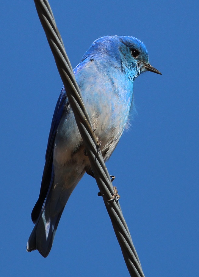
This is a western bluebird, perched on a power line and watching me as I watched it. This is the same species from the cottonwood tree in the Albuquerque Botanic Garden. I’m writing this post while camping in central Arkansas, and I kind of miss those clear blue skies of New Mexico and Arizona. We sure don’t miss the wind, though.Writing about blue skies: this mountain bluebird nearly disappears into them. We’ve seen this species in Colorado several times, including at the cabin near Eleven Mile Reservoir. You can see that the wind was blowing: look at the feathers on his chest.
Lathrop State Park, near Walsenburg, Colorado
We returned to Colorado around the end of April, choosing to camp once again at one of our favorite state parks. Located west of Walsenburg in the southern part of the state, Lathrop State Park has two large lakes, good hiking trails, and incredible views of the Spanish Peaks and Blanca Peak, each of which still had snow. The park attracts an enormous number of permanent and migratory birds each year.
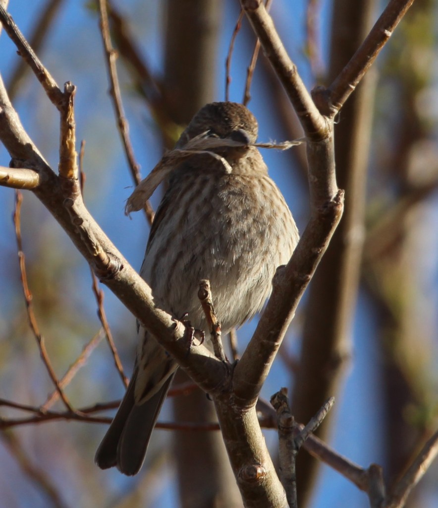
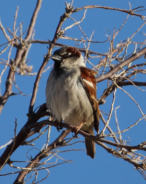
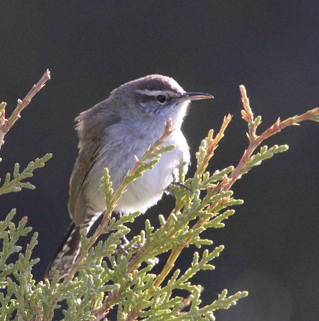
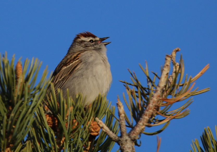
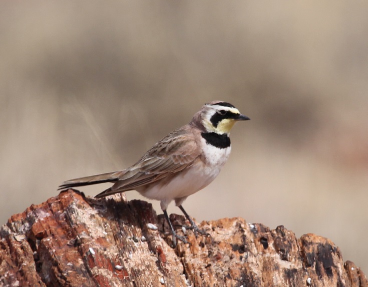
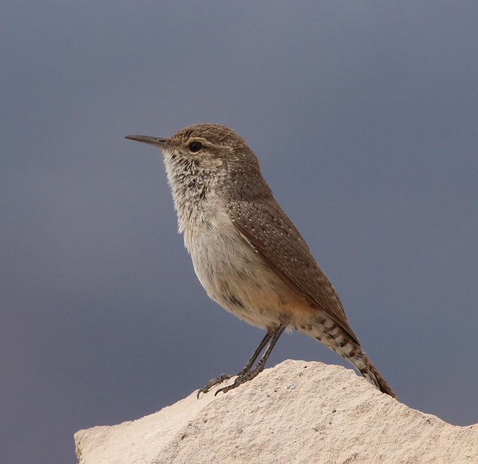
We’d seen a couple of American robins, our first of the spring, at the Albuquerque Botanic Garden, but I couldn’t get any good photos. There were plenty of robins at Lathrop. I’ve learned to recognize their calls, which are really distinctive once you’ve heard them enough.I hiked through the cactus and brush (you’ll notice that most of these songbirds at Lathrop are perched on juniper) north of our campsite one morning and took this photo. I had no idea what kind of bird it was until I looked it up: it’s a tufted titmouse, at the very northern edge of its range in southern Colorado. I’d never heard of them, let alone seen one before. Neat-looking bird, although you don’t see many species, outside of bluebirds and blackbirds, that are all one color.Here’s another new bird to me, from the same morning hike: it’s a Bewick’s wren. I couldn’t get on the other side of it to take advantage of the morning sun, but I kind of like this backlit effect anyway. I’d never seen too many species of wrens before we started full-timing in the Goddard; I’ve since seen several, and they’re very attractive little birds.This is a cropped photo taken with a telephoto lens from a long, long way from this bird, but I’d never seen one before. This is a pied-billed grebe swimming on one of the park’s lakes, and it spent more time submerged than swimming on the surface. I saw eight bird species at Lathrop State Park that I hadn’t yet seen in 2022, and three of them (the last three pictured) were species I’d never seen at all.There were lots and lots of chipping sparrows at Lathrop. I’m not sure if there were more of these or if there were more American robins at the park (and there were a lot of blackbilled magpies, too). Very pretty calls from these little birds.
By the time we left Lathrop State Park on April 24, I’d seen 51 different species of birds in three different states in 2022. It had become obvious that being around water, whether it’s a river or a lake, greatly increases both the chance of seeing birds and the opportunity to see different species of birds. That would become even more clear at the next Colorado state park at which we’d camp.
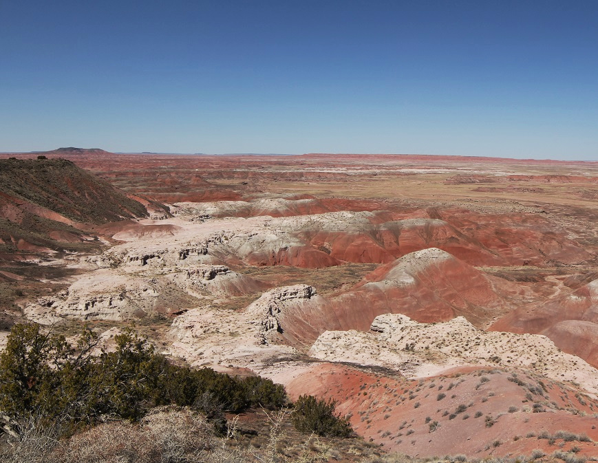
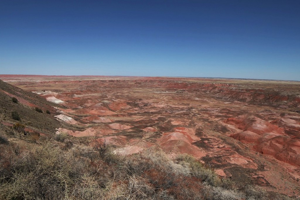
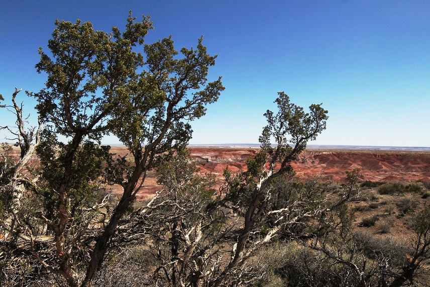
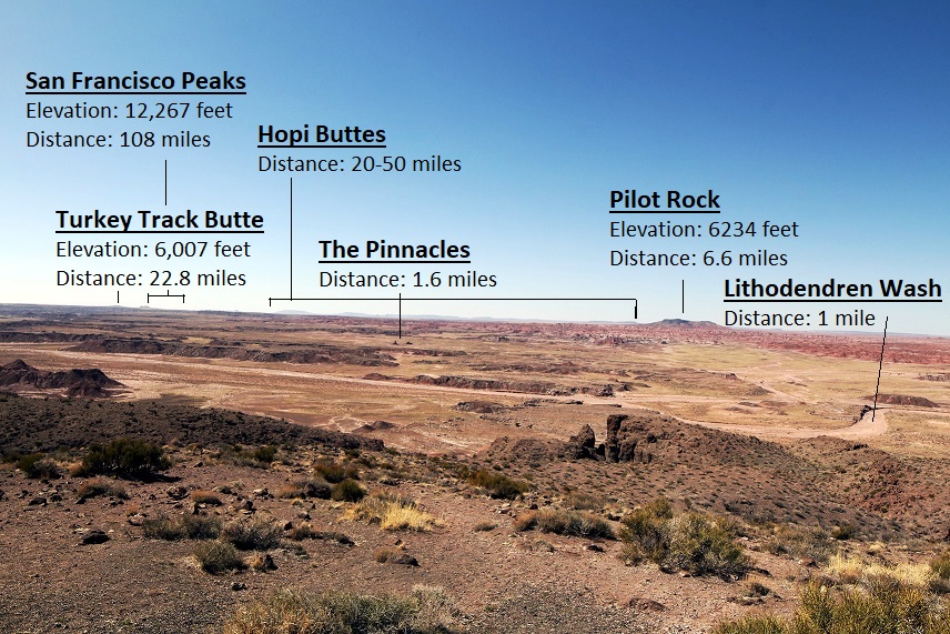
We made our first visit to Petrified Forest National Park on March 25, 2022, restricting our time to only the northern, smaller section of the park. That part doesn’t have much in the way of petrified wood, but it has plenty of awe-inspiring views. We returned the next day, with Gunther, to experience the southern side, and we did see some fossilized wood. And how!
Petrified Forest National Park, which measures about 350 square miles, receives about 600,000 visitors per year. That number, while impressive, makes it just the third-most-visited national park in Arizona, following Saguaro National Park in Tucson (1 million visitors per year; Nancy and I were two of those people a couple of weeks earlier) and the most-visited park in all the land, Grand Canyon National Park (4.5 million). Incidentally, Rocky Mountain National Park in north-central Colorado is just behind Grand Canyon, at 4.4 million visitors per year. If you’ve been to Rocky Mountain National Park in the last 20 years and felt a bit cramped, it’s probably due to 4.4 million other people visiting a park measuring 415 square miles.
Wind and water erosion in the northern Arizona desert does some interesting things to rocks, like resting the one on the right side against the one on the left.
But we’re here to talk about rocks. A piece of petrified wood isn’t really wood any longer: it no longer contains any organic material and it is most definitely a rock. The process of petrification takes several important factors, including a tree, water, sediment, and time. Lots and lots of time.
Many of the rocks at Petrified Forest National Park represent trees that were quite large when they were living, about 220 million years ago. Here we see a park visitor with her dog observing a massive rock. (It’s Nancy, with Gunther, who appears ready to return home to The Goddard but we’d only been at the park for about 30 minutes at this point.)
Let’s start at the beginning. The scientists believe that the trees in Petrified Forest National Park were alive between 210 and 227 million years ago. At that time, the Late Triassic Period, the current area of the park was just north of the equator – in fact, it was close to where Costa Rica is today. The land was much different then: covered with forests of immense trees as well as large rivers and other wetlands. Huge amphibians and early dinosaurs roamed the forests and dwelled in the rivers. (Although there were many dinosaur species in the ensuing years, famous dinosaurs such as Tyrannosaurus rex and Triceratops wouldn’t appear until the Late Cretaceous Period, almost 160 million years later.)
There’s still a lot of detail from the former trees to be seen in their petrified logs. While it appears that the logs have been cut with a chainsaw to achieve those smooth sides, they’ve simply cracked along the crystalline structure of the quartz. That usually happens because of erosional processes: either geologic uplift over millions of years, or supporting materials below the log being removed through relatively quick wind or water action.
Many of these coniferous trees (there are nine species identified in the park; all are now extinct) grew to be enormous: some may have grown to 200 feet in height. When the trees died they lost their branches and bark, then eventually toppled over after being undercut by a river. If the tree fell into the river, it may have eventually been covered in sediment being carried by the waterway. This relatively rapid burial is critical to later petrification: the water sealed the dead tree away from both oxygen and bacteria, which helped prevent decay. That delay gave time for silicic acid in the rivers to percolate throughout the tree. This process chemically altered the wood into a mineral called opal that still retained the tree’s fine features, like the grain of the wood, or indications of where branches once sprouted from the trunk.
This is one of the biggest, if not longest, pieces of fossilized wood in Petrified Forest National Park. “Old Faithful” is 35 feet long and weighs about 44 tons. It’s also one of the relatively few logs that retained part of its root structure, which measures 10 feet across today, during the petrification process. In 1962, lightning struck and fractured this log. The National Park Service used mortar to reattach the pieces and added the retaining wall seen near the base of the former tree – a process that, in the name of resource management, the NPS would probably not undertake today. Old Faithful is located just west of the Rainbow Forest Museum and Visitor Center near the park’s southern entrance.Here we see a park visitor with her faithful dog, standing next to the base of Old Faithful. (It’s Nancy, again, with Gunther, again; the dog appears to have perked up somewhat.)While perhaps not quite as spectacular as the views we enjoyed in the northern part of the park the day before, there were still great vistas to enjoy on the Giant Logs Trail near the visitor center. One can see erosional forces still at work on the rocks at right.
Converting the wood into opal took only a few thousand years. Further layers of sedimentation over millions upon millions of years would cover the logs with tons upon tons of soil and rock. This process recrystallized the logs, converting the opal into quartz and a few other minerals. Over many other ensuing millions of years, erosion and geologic upheaval brought the logs back to the surface of the earth to once again see the light of day – this time as petrified wood.
Now that you know the factors involved in creating petrified wood, can you name the states in our country that contain it? The answer is below – keep on scrollin’!
The silicic acid in ancient waterways percolated through fallen logs, converting the trees’ organic material into opal. This closeup photo shows that the minerals retained the features of the trees, such as the grain of the wood.
The visitor center at the southern end of the park, which is part of the original monument created in 1906 (it was made a national park in 1962), contains some interesting fossils of both trees and animals. The fossilized remains of many amphibians and some dinosaurs dating to the time that the trees were alive have been discovered in the park (and the process for creating animal fossils is much the same as that used to create petrified wood). The museum also exhibits some handwritten letters: apparently, some visitors over the years were unable to withstand the temptation (and federal law) to leave the petrified wood where it lay within the park. Upon their return home with a fossilized wood souvenir, some of them inexplicably fell into bad fortune, such as personal or business relationship issues, and returned the rocks via mail, with an apologetic letter, to the national park.
Some of the many trails within the southern part of the park feature these helpful fossilized logs to help keep hikers on the path. Walking beside them gives an idea of just how tall these trees were.
After going to the visitor center and museum, and walking the Giant Logs Trail behind the building, we decided to go on a longer walk to see some more rocks. The Long Logs Trail, located a short distance from the visitor center, is so named because some of the petrified wood is more than 180 feet in length.
We saw this horned lark while on the Long Logs Trail. It had a very pretty song. We had never seen one before, and were happy to watch and listen to it for a while. (I write “we,” but Gunther couldn’t possibly have cared less.)More than 1,200 archeological sites, indicating prior human habitation as long as 12,000 years ago, have been found in the park. The Native Americans arrived first as nomadic cultures, then over the centuries began to occupy the area on a seasonal basis. Eventually, the cultures lived in what is now the park year-round. A short spur from the Long Logs Trail leads to Agate House, a building that was reconstructed by the NPS to represent an actual seven-room dwelling built by ancient Native Americans, using the only construction material available, petrified wood, about a thousand years ago. Although centuries of weathering caused the original structure to collapse, park service staff used the same rocks to rebuild the house.Realizing it’s a reconstruction, Agate House is still very pretty and was probably fairly resistant to the elements when it was first built.
About the states that contain petrified wood: were you able to name them? If you named all 50, you’re correct. Although each U.S. state contain some amount of petrified wood, northern Arizona is able to display one of the largest concentrations in the nation because of the geologic upheaval processes that brought the logs to the surface of the earth.
This particular log caught my eye because of the many colors it features. It’s simply spectacular. The different mineral composition within the petrified wood contributes to the varied coloration. The rocks can contain natural quartz, which is nearly clear and translucent, as well as varying amounts of iron, copper, manganese, and chromium, all responsible for the reds, yellows, purples, and greens. I would never take any rocks from Petrified Forest National Park. It would have meant that someone else wouldn’t have been able to see this one. However, if I was going to take a rock home, this would have been the one. But we have a weight limit, for towing safety purposes. on The Goddard. Also, I like my luck the way it is.
Progressing east and west, Interstate 40 divides Petrified Forest National Park into northern and southern sections. The interstate generally follows the path of historic U.S. Route 66, which connected the midwestern United States to the country’s west coast in the first half of the 20th century. Although Route 66 stretched more than 2,200 miles from Chicago to Los Angeles, Petrified Forest is the only national park with former segments of the historic highway within its boundaries. The area south of the interstate, much larger in size than the northern part, contains most of the petrified wood specimens in the park. The northern area, however, boasts incredible roadside vistas of the Painted Desert and a sizable national wilderness area. Nancy and I visited the northern part of the park in late March. Gunther stayed with Rusty in the Goddard, but Nancy and I would enjoy the dog’s company when we returned to the park the following day.
We briefly stopped in at the northern visitor center, which was undergoing significant renovation at the time, then proceeded to drive along a route that included a number of overlooks of Petrified Forest National Park.
I decided to use my 14mm wide-angle lens for taking pictures the day we visited the Painted Desert. I got it a couple of years ago to primarily take pictures of the night sky but thought its properties would help capture the feeling of the vast open landscapes of Petrified Forest National Park. There is a disadvantage to using this lens, though: it’s not automatic, so the aperture, ISO, and other settings all must be set manually. I’m no good at any of that. Many of the photos I took were over- or under-exposed, and I had to make manual adjustments using a couple of pieces of photo editing software.
One gets a different perspective of time and distance when visiting this part of Petrified Forest National Park. The different colors in the gullies in the center of the photograph represent 200 million years of sediment being laid down by rivers and then being eroded by later rivers, and the rock formation on the horizon at left, Pilot Rock, is nearly seven miles away. The horizon in the center is much further – perhaps a hundred miles.This view of a deep basin formed from erosion is from one of the first overlooks on a road that goes through the Painted Desert. One can see for, literally, a hundred miles to the horizon. They’re not visible in this photo, but we could see many, many tractor-trailers traversing Interstate 40 on the other side of this huge basin. Sharp-eyed viewers will, however, note a distinct lack of petrified wood in this view; that’s because most of the petrified logs are well south of this part of the park.
Petrified Forest National Park contains only a small part of the Painted Desert, which stretches across almost 8,000 square miles of northeastern Arizona. The colorful rocks, primarily mudstone and sandstone, of this region are called the Chinle Formation. Deposited from 227 to 205 million years ago during the Late Triassic Period while most of the land area on Earth was on the single supercontinent Pangaea, the rocks have been buried, lifted, and eroded during Pangaea’s breakup and shift into today’s major continents.
There are still living trees to be found in Petrified Forest National Park, but they’re nothing like the towering conifers that grew 200 million years ago when the area was located at about present-day Costa Rica. The park’s overlooks are built on a layer of basaltic rock that was ejected from volcanic eruptions only between 16 and five million years ago, forming a protective layer that is much more resistant to erosion than the sedimentary layers of rock below.
During the Late Triassic Period, the land comprising Arizona’s Petrified Forest National Park was located just north of the equator and supported a much different environment (different enough, for example, to support a forest of 180-foot-tall trees that would later become petrified). As Pangaea divided, the land mass migrated north and the land itself underwent massive changes.
The different colors seen in the Painted Desert are quite impressive. Large river systems flowed through this area hundreds of millions of years ago, depositing many layers of gravel, silt, and sand. The different colors of the layers are created by varying mineral content of the soils, which have been exposed through geologic movement as well as water and wind erosion.
The Chinle Formation is itself divided into five members: Mesa Redondo, Blue Mesa, Sonsela, Petrified Forest, and Owl Rock. Each member represents a transition of the land from wet to dry environments over millions of years: the Mesa Redondo, the oldest layer and therefore the one underlying the rest of the formation, consists of red sandstone originally laid down 226 million years ago, and the youngest, Owl Rock, includes pink and orange mudstone at the top of the formation that was deposited 207 million years ago.
Here we see a visitor to Petrified Forest National Park (it’s Nancy) contemplate more than 200 million years of geologic change that resulted in these magnificent views.
Older rock formations in the Painted Desert are at the bottom of the geologic column, and the layers of rock grow younger in age as the elevation increases. The colors of these rocks come from the iron they contain. Drier climates allow the minerals to become exposed to oxygen, causing the iron to rust and develop distinctive red, brown, and orange colors. When the climate is wet, moisture essentially covers the sediments and prevents their oxidation. Those layers are colored blue, gray, and purple.
I think a lot of people might underestimate just how wide-open the American West can be. This picture, taken from the Pintado Point overlook at the national park, gives an idea of how far one can see in the northern Arizona desert. For instance, Turkey Track Butte is nearly 23 miles away from this viewpoint but is still distinctly visible. Behind the butte, the San Francisco Peaks are barely discernable, but they’re more than a hundred miles away. Pilot Rock is the highest point in the park, and Lithodendren Wash is a seasonal stream.
Nancy and I took a short hike along the rim of the basin, and one of the highlights of that walk was a stop at the Painted Desert Inn, which was originally built as a respite for travelers on Route 66. The highway passed just a short distance south of the building, and a spur road brought visitors to the inn for refreshments.
Records are unclear regarding exactly when the building was first constructed, but descendants of the original owner say he built it in the late teens of the 20th century. The Painted Desert Inn had several owners during the course of its life as a place of rest for Route 66 travelers, but the U.S. government bought the building and four surrounding square miles of land in 1936. Petrified Forest National Monument had been established 30 years earlier, and the area became a national park in 1962.
The interior of the Painted Desert Inn now serves as a visitor center for the Painted Desert as well as a museum with artifacts from the inn’s heyday. It’s all very impressive and you’re going to have to take my word on that because none of the pictures I took inside turned out.
Despite my photographic foibles, we really enjoyed this first visit to Petrified Forest National Park. I grew up on the eastern plains of Colorado, and I know long, uninterrupted distances. They are nothing compared to what can be seen in northeastern Arizona.
We’d see more of the park, and a little bit of actual fossilized wood, the next day. (Actually, we’d see a lot of fossilized wood. So. Much. Fossilized. Wood.)
Holbrook, Arizona, located in the northeastern corner of the state, is the seat of Navajo County, which was split off from neighboring Apache County in 1895. Both counties are still huge: Navajo measures 9,960 square miles, and Apache still has more than 11,000 square miles even after the division. Navajo County is bigger than the state of Vermont and just slightly smaller than Massachusetts. (For reference, my home county in eastern Colorado, Kit Carson, is considered very large at 2,162 square miles; in fact, Navajo County is about a tenth the size of the entire state of Colorado.)
Nearly two-thirds of Navajo County is designated Native American reservation land, including parts of the Hopi Indian reservation, the Navajo Nation, and Fort Apache Indian Reservation.
We camped in Holbrook for a week because of the town’s close proximity to Petrified Forest National Park – the park is only 25 miles northeast of the city – but we found plenty to like about the town itself.
The Navajo County Courthouse, completed nearly 125 years ago, is now home to the Navajo County Historical Society’s museum. Built in 1898 at a cost of $15,000, including a $3,000 jail, the courthouse was in use until 1976 when the Navajo County Correctional Complex was constructed on the south side of Holbrook.
Construction of the Navajo County Courthouse in Holbrook, Arizona, was completed in 1898. The courtroom and jail are on the right side of the building. You can probably determine on which floor each is located: one has cloth curtains on its windows and the other has metal bars.
The museum was open on a Sunday afternoon in March after the Goddard’s arrival in Holbrook, so we were able to spend a few pleasant hours touring the exhibits.
The first exhibit in the museum is the county jail, which is to the right after one enters the courthouse. The jail was built in Kansas City, Missouri, by the Pauly Jail Company, which began operations in 1856 and is still in business today – be sure to consider it for any incarceration needs you may have. The jail was then shipped by rail to Holbrook and placed in the still-under-construction courthouse.
The jail’s desk and other office furniture is on display in the office. That’s a receipt book along with some historic postcards on the desk. The longhorns at top left allude to Navajo County’s ranching heritage, which is extensive.Here’s a handy feature located in the wall across from that desk: it’s a peephole covered by a swinging cover that affords a view into the detention area …… and here’s what one sees if one looks through that peephole. The sleeping accommodations are somewhat spartan.I don’t know how often you consider turning to a life of crime, but I know that when I do I make myself think of scenes like these and my thoughts quickly change to other, less illegal pursuits. Nancy and I didn’t have an opportunity to visit the new correctional facilities in Holbrook, so I don’t know how they compare to these. One would think they’re an improvement.
Firmly deciding to continue living our lives on the straight and narrow path, Nancy and I proceeded to other parts of the museum. Volunteers for the Navajo County Historical Society spend more than 2,000 hours each year curating and conserving artifacts from Holbrook’s past. The items represent the lives of Native Americans, Euro-American settlers, ranchers and cowboys, bankers, homemakers, railroad employees, teachers, merchants, and travelers through the area over the past centuries. Like many community historical museums we’ve visited, the exhibits in the building show a tremendous range of cultural, social, and economic pursuits. I wish other museums, however, were as well curated as Holbrook’s: the society has really done a fine job of keeping the exhibits relevant and reasonably sized.
The Mother Road
Holbrook makes much of its location on the former Route 66, one of the original highways of the U.S. Highway System. Established in 1926, Route 66 connected Chicago, Illinois, with Santa Monica, California, and passed through the states of Missouri, Kansas, Oklahoma, Texas, New Mexico, and Arizona in its 2,448 miles.
Route 66 was an extraordinarily important highway in the first half of the 20th century, serving as the primary means by which Americans migrated to the West – especially during the Great Depression (John Steinbeck’s novel “Grapes of Wrath” alludes heavily to the highway). The route proved to be an essential economic driver for dozens of cities and towns along the way, as businesses provided food, fuel, shelter, and services to those who traveled the highway. Route 66 was officially removed from the U.S. Highway System in 1985, having been mostly replaced by a variety of segments of the U.S. Interstate Highway System.
The museum displays interesting artifacts from Route 66, and Holbrook itself makes many references to the highway along its former route. While we were in Albuquerque, New Mexico, we also saw many references to Route 66 (according to the mileage chart in the display above, Albuquerque is 1,329 miles from Chicago).This marker for mile 322 on Route 66 was originally located east of Petrified Forest National Park – Holbrook today is at mile markers 285 and 286 on Interstate 40, which follows the path of Route 66 in northern Arizona, New Mexico, and Texas. The interstate highway splits Petrified Forest National Park into two parts, and the 350-square-mile park is located in both Navajo and Apache counties. This is a really attractive mile marker, and I wonder how many of them are still around.
The Hashknife Outfit
In addition to the town’s Route 66 connection, the Holbrook museum also features extensive exhibits on the Aztec Land & Cattle Company. The company was founded in Boston, Massachusetts, in 1884 to take advantage of significant drops in cattle prices in Texas. Many large ranches in that state had continued to add to their herds, intending to reap profits when the beef markets improved. However, lingering drought caused prices to drop even further.
Aztec bought the Continental Cattle Company and its Hashknife brand (so called because the cattle brand resembled a bladed kitchen utensil), then shipped a total of 60,000 cattle and 2,200 horses from Texas to northeastern Arizona. The cattle were grazed on land purchased for 50 cents an acre from the Atlantic & Pacific Railroad. The grazing lands stretched about 300 miles from just south of Flagstaff to the New Mexico border (Arizona and New Mexico were both U.S. territories until 1912). With the ranch headquarters in Holbrook, the company’s employee base was a significant economic force for the town. However, Holbrook’s population of 300 residents found that not all of the Hashknife Outfit’s cowboys were of the law-abiding type. Cases of armed robbery and cattle rustling escalated, and there were 26 shooting deaths in 1886 (again, in a town of 300 people).
The Aztec Land & Cattle Company’s cattle brand looks a lot like this handy-dandy kitchen utensil, called a hashknife.
As was typical in the days of the Old West, range wars involving different ranches and their possessions were common. Many of the cowboys involved, either current or former Aztec employees, were incarcerated or outright killed.
The original end of Aztec as a beef-raising company came in 1902, with a drought, flooding, and overgrazing that destroyed the land on which the cattle were grazed. Aztec sold off its land and its remaining cattle, and the Hashknife brand was sold to a family in Flagstaff (and Aztec continues today as the third-largest private landowner in Arizona).
However, many of the cowboys of the Hashknife Outfit would go on to become respectable citizens of Holbrook and the surrounding area as independent ranchers, law enforcement officers, businessmen, and community leaders.
Although it was definitely the largest, the Aztec Cattle & Land Company wasn’t the only cattle concern around Holbrook and the museum has many artifacts about the ranching way of life.
Is it really a Western historical museum if it doesn’t feature a barbed wire exhibit? I think not. These barbed wire examples from the early Holbrook area date from the mid-1870s and 1880s.
Charles Goodnight, a Texas rancher and cattle trail developer, is credited with introducing the chuckwagon, a mobile kitchen used to keep cowboys’ bellies full, in 1866. Goodnight’s model was a modified wagon from the U.S. Civil War, to which he added a box with drawers and shelves for food and supply storage. Goodnight’s cattle drives took cattle from Texas to New Mexico on the Goodnight-Loving Trail (which also followed part of the Butterfield Overland Mail route). He’d later go on to drive cattle from New Mexico up into Colorado and Wyoming. Cooks for the cattle drives would also serve as barbers, dentists, and bankers for the outfits, and were so important that they were usually second in command to the trailbosses.
This particular chuckwagon belonged to George Hennessy (1877-1974), who was mayor of Holbrook in 1918 and was married to the daughter of the Hashknife Outfit’s foreman. Another resident of Holbrook, C.F. Lee, owned the wagon later, and his son, who donated the wagon to the Holbrook museum, said it was special to his father because, as a teenager on his first cattle roundup, he ate off this chuckwagon.
Back to the Triassic
One of the things I really appreciate about community historical museums is the breadth of items they display. The artifacts can range in dates from the times of ancient Native American cultures up to the Great Depression of the 1930s and even more recent. As I wrote, the Navajo County Historical Society has excelled at displaying just a few items from each era in order to abstain from overwhelming visitors. Let’s go back even further in time for a moment:
This is the fossilized skull of a critter still needing positive scientific identification, found about a mile east of present-day Holbrook. It is likely an amphibian that lived during the Triassic period, 250 to 200 million years ago. The skull is maybe 18 inches wide. Holbrook is, of course, also near Petrified Forest National Park and its huge fossilized trees that lived about 225 million years ago.Writing of hard things, this is an example of an adobe brick from an early Holbrook building. Many of the buildings of the city are constructed from adobe, which has since been stuccoed to prevent erosion. Adobe is, of course, a time-honored construction material in the American southwest. This display also included other building materials, including sandstone blocks and red clay bricks, from since-demolished Holbrook buildings.The citizens of Navajo County have long held a strong interest in preserving the past. In 1940, the war in Europe was threatening to spill over into other parts of the world, including the United States. Political leaders in Navajo County wrote a prayer for peace and sealed it in the three-inch galvanized pipe shown above. The capsule was then deposited in the left pilaster of the courthouse entrance. Other items included in the time capsule included two buffalo nickels, two March of Dimes pins, a newspaper from 1940, an election ballot form, and a number of written letters. The capsule was unearthed in 1995 during an annual celebration in Holbrook. In 1998, the contents of the time capsule along with other items from that year were reburied in a PVC pipe in the same location, and officials decreed that the plastic time capsule will be reopened in the year 2098. The courtroom, located on the courthouse’s second floor, looks much like it did in the final days of its use in 1976. The jury seats are on the left, and museum exhibits are on the room’s other walls. The judge’s chambers and legal library, through the door to the left of the exhibit cases, are also preserved. After the courthouse’s construction, this room was also used for community dances until it was decided that the festivities were putting too much weight on the floor. Note the ornate design of the ceiling. I don’t know how much time you’ve spent in courtrooms, willfully or not, but for some reason they always have a calming effect on me. I took this photo of the courthouse’s front door as we were leaving the museum. There’ve been a lot of people who walked through this door in the last 124 years: some to face a trial, some to pay a county bill, some to attend a dance in the courtroom (when that was still permitted). The door and its hardware have a lot of character, and they’re just a few steps from the PVC time capsule that will be reopened in just over three-quarters of a century.
We enjoyed a one-week stay in Camp Verde, Arizona, in mid-March of 2022, which allowed easy access to two National Park Service (NPS) sites. The first was Montezuma Castle National Monument, a cliff dwelling on which construction began a thousand years ago and which we visited on a couple of consecutive weekday late afternoons. The second was Tuzigoot National Monument, another ancient Native American dwelling site located about 20 miles northwest of Camp Verde. Tuzigoot was declared a national monument on July 25, 1939. Nancy and I visited the monument on a pleasant but overcast Saturday in mid-March.
Look closely at the top of the tower: that’s a group of about a dozen people. Tuzigoot is a big place.
Like the nearby Montezuma Castle, the Sinagua Native Americans began construction on Tuzigoot pueblo about a thousand years ago. Also like Montezuma Castle, Tuzigoot is misnamed: it’s a corruption of the Tonto Apache phrase “Tú Digiz,” which means “crooked water” and refers to a bend in the nearby Verde River. The pueblo, located on a hilltop with 360-degree views for miles around the area, featured 110 rooms.
The proximity to Montezuma Castle, and to other pueblo communities like those in New Mexico’s Aztec Ruins National Monument and Bandelier National Monument, as well as Colorado’s Mesa Verde National Park, points to the fact that the residents traveled frequently between the dwellings and traded ideas and goods with each other. Again, much like the other pueblos in the area, the dwellings were abandoned beginning in the 1300s most likely due to a variety of reasons (depletion of natural resources, climate change, possible threats from other native cultures) rather than just one. Also, the Hopi, who count themselves among the Sinagua culture’s descendants, believe their forebears were naturally nomadic and didn’t like to stay in one place for too long.
The Tuzigoot National Monument experience begins with the site’s visitor center, which is itself a historic structure (although not as historic as the pueblo, since the visitor center dates only to 1936). The visitor center was built as a museum by local Clarkdale residents, who also helped professional archeologists with the initial excavation of the Tuzigoot pueblo. The center contains actual artifacts – not reproductions – that were found during the site’s excavation in the 1930s.
Here we see a Tuzigoot visitor (it’s Nancy), freshly armed with knowledge gained from the visitor center as well as a pair of binoculars, ready to begin her 1/3-mile trek to the pueblo. The center is a really cool building, both on the inside and the outside.
The visitor center is on the National Register of Historic Places and has a collection of 3,158 objects, not all of which are on display. The collection includes ollas (large pottery pieces serving as bowls or baskets), woven baskets, projectile points, and jewelry.
The visitor center has an extensive collection of artifacts from the Tuzigoot pueblo as well as from other ancient communities. Men and women from Clarkdale logged more than 34,000 hours excavating and conserving more than 150 pieces of pottery. These pieces, acquired back in the day by trading with natives from neighboring pueblos, date from the years 800 to 1375. I really enjoyed these twig figures that represent mammals – they date from 4,000 to 2,000 years ago, but you probably read that. They’re each about four to six inches wide.This example of a reconstructed wall from the pueblo shows how thick the structures were. That NPS flyer, placed helpfully by a visitor (me), is 8.25 inches wide. As anyone who’s ever built a pueblo knows, thick walls make for good insulation. Summer temperatures in the Verde Valley reach into the 90s, and wintertime lows commonly dip into the 30s.We were happy to have some excellent birdwatching opportunities at Tuzigoot. This lesser goldfinch (Spinus psaltria) was singing a happy tune just outside the monument’s visitor center. These may be the smallest finches in the world: males generally range from 3.5 to 4 inches long and weigh between a quarter ounce and four-tenths of an ounce. Much of their diet consists of dandelion seeds.The visitor center also has a nice native plant collection. This is a specimen of ocotillo (Fouquieria splendens), which translates to “stay far, far away” in Spanish (not really). Although it looks like a cactus, it’s genetically related more closely to tea and blueberries (really). Ocotillo can grow up to 30 feet tall and is sometimes planted as a living fence.Desertbroom (Baccharis sarothroides) is a flowering shrub native to the Sonoran Desert of the southwestern United States and northern Mexico. Tea made from steeping the twigs helps alleviate pain from sore muscles. The plant is rich in compounds that reduce cholesterol and serve as an antioxidant. However, there’s also evidence showing that ingesting the compounds has its share of negative side effects so don’t go drinking that tea just yet.
The Tuzigoot site was first described by Anglo-Americans in the 1850s but wasn’t professionally excavated for nearly a century after that. Following the departure of the Sinagua, centuries of neglect, along with countless rain- and snowstorms, freezing temperatures, and the desert heat, left the pueblo in severe disrepair. The site was first excavated in the early 1930s and Portland cement was used to stabilize the rocks. Unfortunately, that material can, over time, damage the original rocks used in the buildings. In the late 1990s, researchers began to replace the Portland cement with mortar that is a better match with the bonding materials that were used a thousand years ago during initial construction.
This is from the top of the highest tower in the pueblo, looking southeast. The trees just on the other side of the meadow indicate where the Verde River flows. A couple of visitors to the left of the fence on the right side of the image provide a sense of scale. The pueblo was built on a hill that’s 120 feet higher than the surrounding terrain. Nancy and I are fond of pointing out signs like this, which are necessary for exactly one reason. This rock wren (Salpinctes obsoletus) was also happily singing, but on the rocks of the pueblo. They are also a very small bird, about 5-6 inches long and weighing half an ounce. Rock wrens are known for laying down a pathway of small stones outside their nests, which are located in rock crevices or in tree stumps.Tuzigoot visitors are allowed to enter some of the rooms. This one allows access, via a steep set of stairs, to the top of the tower shown in the first photograph. The ceiling shows the viga-and-latilla (large logs crossed with perpendicular smaller logs) ceiling that also served as the supporting floor for the upper story.Looking southwest from the high tower of Tuzigoot, the town of Jerome, Arizona, is visible from the top of the pueblo. Five centuries after the Sinagua left Tuzigoot, Jerome was founded at this location because of the nearby hill featuring a large capital letter “J.” I’m just kidding with you right now: the town was founded there because of the presence of immense amounts of copper underneath it. The copper mines have since played out. In 1930, Jerome had a population of close to 5,000 people and it now has around 500 residents. Also note the snow on the nearby mountains; Jerome is about 100 miles north of Phoenix and lies at an elevation of about 5,000 feet.
The 190-mile-long Verde River, which flows to the north and east of the Tuzigoot pueblo, drains an area of almost 6,200 square miles. The Verde flows just a few feet from where our campsite was in Camp Verde, which derives its name from the river. It eventually empties into the Salt River east of Phoenix, which in turn flows into the Gila River west of the city. A nice trail leads north from the Tuzigoot visitor center to a natural area called Tavasci Marsh (named after the family that once owned a dairy there). About 10,000 years ago the marsh was part of the river but it has since been separated through erosion and other geological forces to become a separate, but connected, wetland. There were, hundreds of years ago, many marshes in the Verde Valley. They’ve since been drained for human development and pasturelands, and today marshes are very rare in Arizona. The trail is a half-mile walk to an observation deck that overlooks the marsh, and there are more opportunities for birdwatching and plant appreciation.
I really like this plant, which we’d also seen at Saguaro National Park outside of Tucson, Arizona. It’s desert Christmas cactus (Cylindropuntia leptocaulis), and its pretty red berries were used by Native Americans to create an intoxicating beverage.Sparrows aren’t generally thought of as especially attractive birds (I disagree), but the black-throated sparrow (Amphispiza bilineata) is definitely an exception. These desert natives are 4.5 to 5.5 inches long and weigh about half an ounce. Black-throated sparrows are extremely well-adapted to their desert habitat (they’re also known as desert sparrows in the southwest); while they get a lot of their moisture from water sources during wet times, during dry periods they derive almost all of their necessary moisture from eating insects. This handsome sparrow was hanging out near the trail to Tavasci Marsh.It wouldn’t be a visit to a Sonoran Desert site without seeing the strawberry hedgehog cactus. They just have ridiculously long thorns compared to their body size.This is Tavasci Marsh, one of the few remaining wetlands of its type in Arizona. Nearly 245 species of birds have been documented in this riparian area and the marsh attracts plenty of other wildlife – none of which happened to be visiting during our time overlooking the area, but that’s totally alright because we saw plenty of other birds on the trails during our visit.
Tuzigoot National Monument is a fine example of the diversity of ancient Native American pueblos. As conserved by the National Park Service, the monument is a great opportunity to not only learn about its former residents, but to also see some great natural attractions.