Until 1947, the U.S. Air Force was a component of the U.S. Army (during World War II the branch was known as the United States Army Air Forces). In 1966, during a celebration of the anniversary of the establishment of the U.S. Air Force, military commanders in the Tucson area realized that many of the historic World War II- and 1950s-era aircraft stored on Davis-Monthan Air Force Base were being lost – as was much of U.S. military history. Airplane parts were being sent to smelters so their metal could be used in modern aircraft production. Base officials began to set aside examples of the aircraft along the base’s fenced perimeter so that the public could see them. Although the practice saved many aircraft from the smelter, this wasn’t an ideal solution. The Tucson Air Museum Foundation of Pima County was formed that year, and the foundation found a 320-acre site of BLM land just south of the Air Force base. The foundation’s first aircraft acquisition was a B-24 Liberator. Many years (and hanger constructions and aircraft acquisitions and hanger expansions) later, the Pima Air & Space Museum is the country’s largest non-government-funded aviation museum. The museum has more than 100 civilian, military, and experimental aircraft in its four indoor hangers (totaling a quarter-million square feet) alone, as well as many more parked on the grounds outside for a total of about 400 aircraft.
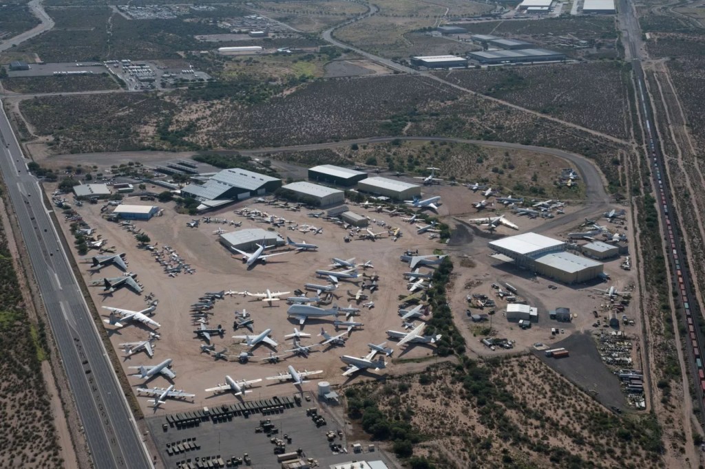
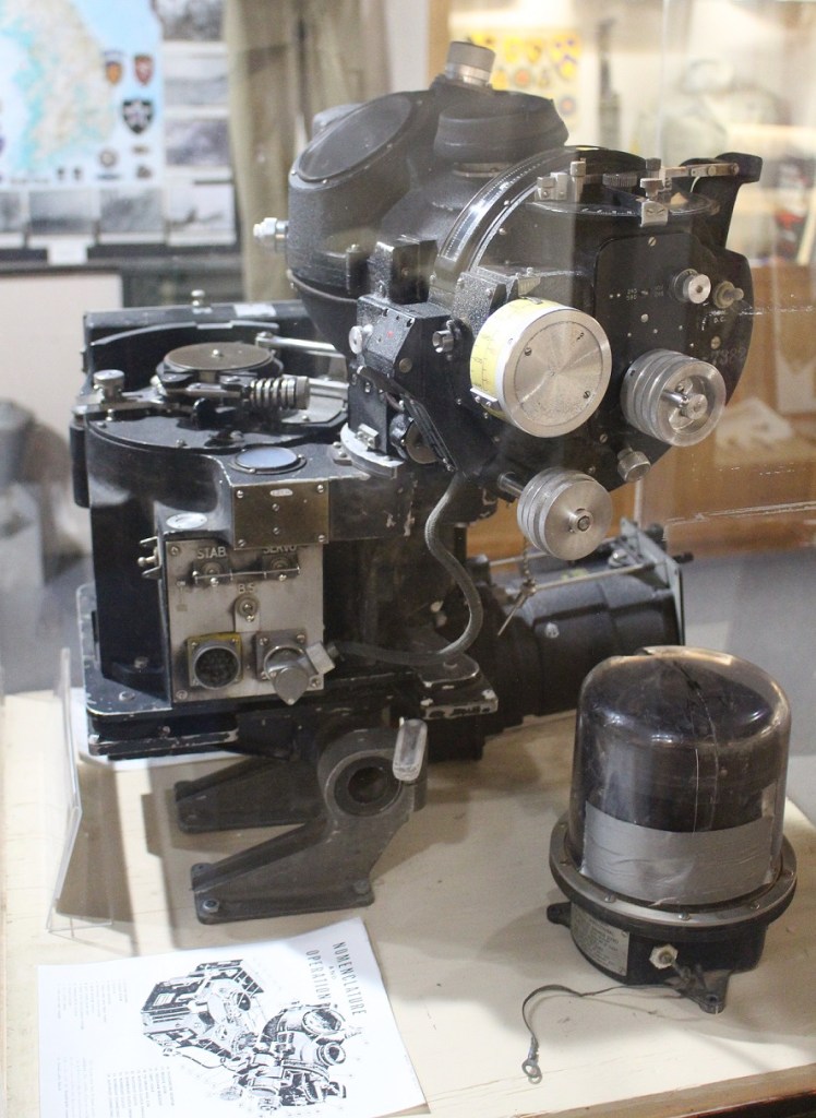
This overhead shot of the Pima Air & Space Museum shows the extent of the museum’s collection [for a sense of scale, the two large gray aircraft next to each other on the left side are B-52 Stratofortresses (Stratofortressi?); they each have wingspans of 185 feet]. The four hangars open to the public are at the top of the photo (courtesy of the Pima Air & Space Museum).
Recognizing that its collection is large and takes aircraft enthusiasts a lot of time to visit, the museum smartly offers a two-day pass that Nancy and I took advantage of. Because March 4 was pretty breezy, we opted to spend that day looking at the aircraft inside the hangers. I’ll share just a few of the ones that I enjoyed viewing, listed in order of their year of introduction.
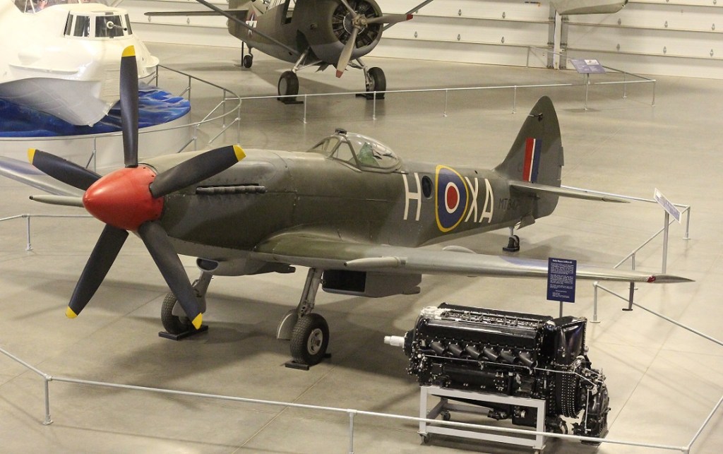
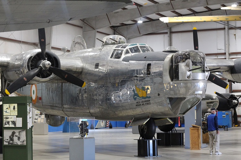
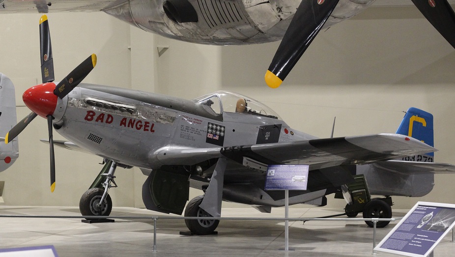
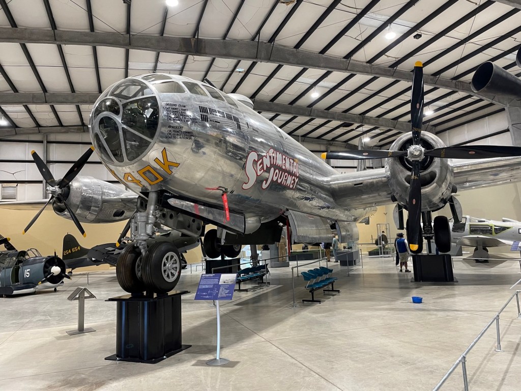
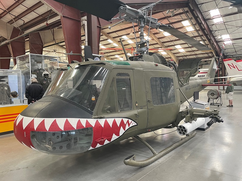
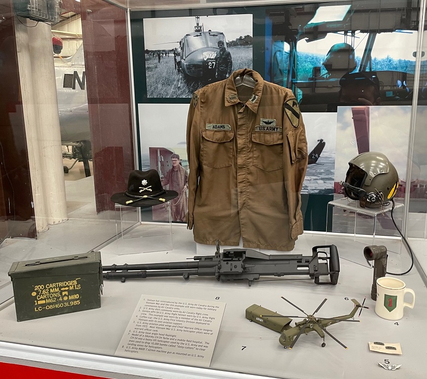
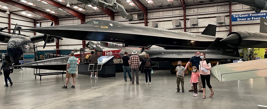
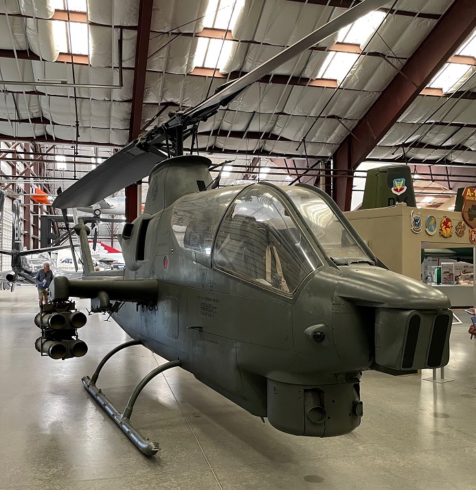
Introduced in 1939, the Curtiss P-40E-1 Warhawk was heavily used by not just the U.S. Army Air Force, but also the Royal Air Force, the Royal Canadian Air Force, and the Royal Australian Air Force during action in World War II. With a production number of 13,378 aircraft, it was the third-most produced American fighter of the war following the P-51 Mustang and P-47 Thunderbolt. The Warhawk lacked a dual-speed supercharger and therefore couldn’t compete in high-altitude combat against the Luftwaffe’s fighters in Europe. It did, however, perform admirably in the theaters of North Africa, the Southwest Pacific, and China. The Warhawk had a top speed of 334 mph.It was a tremendous pleasure to stand next to this aircraft, one of my favorites of all time. This is the Supermarine Spitfire Fr. XIVe. The Spitfire is recognized as the best British-made fighter of World War II. Along with the Hawker Hurricane, this is the aircraft (or rather, an earlier version of it) that defended London and its environs during the Battle of Britain (July-October 1940). Although more Hurricanes were involved with the battle, the Spitfire’s higher performance gave it a higher victory-to-loss ratio. The aircraft’s design was modified constantly during the course of the war, improving performance through engine changes, wing design, and other alterations. From an aesthetics standpoint I actually prefer earlier versions of the Spitfire in which the fuselage extends to the tail, but the bubble canopy afforded pilots much-improved views. That’s a Rolls-Royce Griffon 65 engine near the left wing, the same V-12 liquid-cooled model that would have been used in this model of Spitfire (earlier models used the Rolls Royce Merlin engine). The Griffon saw widespread use beginning in 1941 and remained in production until 1955. It had a rating output of 1,730-2,420 horsepower. In order to accommodate the Griffon engine, the Spitfire’s nose had to be redesigned and the propeller went from three blades to five. With the Griffon engine, the Mark XIV had a top speed of 446 mph – 20 percent faster than the first production models. Nancy and I appreciated that many of the aircraft on display at the museum had a representative corresponding engine next to them. The last Spitfires were retired from active duty in 1961, but about 70 (out of 20,351 produced) of the aircraft remain airworthy.The Consolidated B-24 Liberator, introduced in 1941, was used by every branch of the U.S. military in every theater of the war. About 18,500 Liberators were made, including 8,685 by the Ford Motor Company at its Willow Run manufacturing plant near Belleville, Michigan (incidentally, we have camping plans at a campground near the site of that plant in August). The B-24 was the world’s most-produced bomber, multi-engine aircraft, and American military craft in history. The B-24 had a cruising speed of 215 mph (maximum speed of 297 mph) and a range of 1,540 miles. American technological advances by the end of the war (including the development of the B-29 Superfortress, which had a range nearly three times that of the Liberator) made the B-24 obsolete. The fellow in the blue vest at lower right is a docent for the Pima Air & Space Museum; although he’s not a World War II veteran, he had a lot of interesting information to share about the B-24. The youngest of America’s World War II veterans were born around 1927. My family has an interesting history with the B-24: one of my mom’s uncles and one of my dad’s uncles were best friends at McPherson College in McPherson, Kansas, and flew the Liberator from North Africa together, about 25 years before my parents met. Here’s another one of my favorites: the North American P-51 Mustang. Before the United States’ official entry into World War II, British military authorities had approached North American to build P-40 Warhawks but the company decided instead to build a more modern aircraft of its own design. A prototype of the P-51 was rolled out about three months after the contract was signed, and the Royal Air Force was flying Mustangs in January 1942. The first Mustangs were underpowered compared to other contemporary fighters, but that problem was rectified when the P-51s were fitted with Rolls-Royce Merlin engines. This P-51D had six .50 caliber machine guns rather than the four in earlier versions and could reach an airspeed of 437 mph. More than 15,000 P-51s were built; the last Mustang left U.S. military service in 1957 and the last Mustang left other forces (the Dominican Republic Air Force) in 1984. Nearly 100 Mustangs in private ownership are still flying.The Boeing B-29 Superfortress was introduced in 1944, toward the end of World War II, but it certainly left its mark. B-29s carried more bombs, higher, farther, and faster than any other bomber. Superfortresses had a maximum speed of 358 mph, a range of 4,100 miles, and a service ceiling of nearly 32,000 feet. Over 3,000 B-29s were built and many continued to serve not only as bombers, but as reconnaissance planes and fuel tankers, into the early 1950s.This particular Superfortress, serial number 44-70016, served with the 330th Bomb Group and flew a total of 32 combat missions over Japan. It was retired in 1959. While most of the Pima Air & Space Museum’s collection is devoted to military aircraft, there are plenty of civilian airplanes on display as well – including some suspended from the ceilings of its hangers. This is a Taylorcraft BC-12D, introduced in 1945. It has a maximum speed of 105 mph. My dad, Steve Goering, became a licensed pilot as a young man and has since flown quite a few different fixed- and rotary-wing aircraft. A number of years ago he flew a Taylorcraft BC-12 belonging to a family friend. That’s a Hughes OH-6 Cayuse, a helicopter introduced in 1963, behind the Taylorcraft – Dad flew one of those when he first went to Vietnam as a U.S. Army helicopter pilot during his in-country orientation flight in the late 1960s.The North American F-86 Sabre was the best known aircraft of the United States’ first jet fighters. Design work began as World War II was ending in 1945, and the first prototype flew in August 1947. It was the first swept-wing jet fighter to enter American service, and, in a dive, exceeded Mach 1 – another first for an American aircraft. Sabres had a top level speed of 599 mph, and made their name during the Korean War. Eventually, 25 different countries would use Sabres in their armed forces. This particular model, an F-86E, was delivered to the U.S. Air Force in April 1951. It was first assigned to Japan and then transferred to Korea for the remainder of that war. It was retired in 1959.The Grumman F-9F Cougar was originally envisioned to simply be a swept-wing version of the F-9F Panther, one of the first carrier-based fighters in the U.S. Navy, but despite retaining the F-9 designation it was a different aircraft altogether. The new design gave the Navy an aircraft capable of competing with the Soviet Union’s swept-wing MiG-15 aircraft, which was very effective in the skies over Korea. Grumman delivered the first F-9F Cougars in December 1952. This aircraft, an F9F-8P photo reconnaissance model, had a top level speed of 637 mph – still subsonic, but fast enough to compare with the MiG-15. In 1954, a U.S. Navy pilot set the transcontinental crossing speed record in a Cougar, completing the 2,438-mile flight in just over 3 hours and 45 minutes – it was the first time that the distance had been covered in less than 4 hours. Grumman produced almost 2,000 F-9F Cougars; the last Cougar was retired in 1974.Introduced in 1958, the Bell UH-1 Iroquois is perhaps the most-recognized helicopter in the world. Versions of the Huey (the nickname is derived from the original U.S. Army designation of HU-1, and it’s certainly better known than “Iroquois”) remain in both military and civilian service today. More than 16,000 Hueys have been built since its introduction. Each branch of the U.S. military had its own version of the Iroquois by the mid-1960s, and the helicopter is perhaps best known for its use by the U.S. Army in Vietnam as a gunship, as well as cargo transport, medical evacuation, search and rescue, and other operations. The Army used 7,000 Hueys during its operations in Vietnam in the 1960s and 1970s. The first Iroquois had a maximum speed of 127 mph and its various armaments included 7.62mm machine guns and 70mm rocket pods. My dad flew UH-1s as an Army instructor at Fort Rucker, Alabama, where he was an instructor; as well as in operations at Wertheim Army Airfield, West Germany; and at Fort Carson, Colorado. The particular UH-1 shown is from the 174th Assault Helicopter Company, deployed at Duc Pho in Quang Ngai Province from 1967-1970. The 174th was a sister unit of my dad’s F Troop, 8th Cavalry Regiment at Chu Lai, about 40 miles from the 174th. While at the museum I saw a few men my dad’s age walking slowly around this Huey – their memories were their own, but they were almost palpable.This exhibit shows a variety of memorabilia from Vietnam-era helicopter operations. The U.S. Army Air Cavalry reintroduced the Stetson hat (to the left of the shirt) during the Vietnam War, and the Stetson hat is still worn during the Air Cavalry’s military ceremonies. The hats were originally worn beginning in the 1870s by U.S. Cavalry soldiers. The helmet, at right of the shirt, is a Gentex APH-5A worn by U.S. Army flight crew. The flashlight below the helmet is an Army-issued angle-head model. That’s a model of the Sikorsky CH-54 Tarhe helicopter to the left of the flashlight, along with a model of a mobile field hospital. In the center is a U.S. Army M60D 7.62mm machine gun, as mounted on U.S. Army helicopters. This display brought back a lot of memories for me (well, not so much the M60, but the shirt, helmet, and flashlight certainly did).The neat thing about a lot of aircraft museums is the range of technology on display. The first aircraft you see when entering the main hanger is a reproduction of a Wright Flyer, which the Wright brothers flew a few feet above the North Carolina sand dunes in 1903 with a top speed of 30 mph. Then there’s this Lockheed SR-71 Blackbird, introduced in 1966 and with a top speed of 2,200 mph and a service ceiling of 16 miles above the Earth. Sixty-three years isn’t that much time, but look how far aviation advanced in that period. We’d put men on the moon and bring them back to Earth 66 years after the Wright Flyer took off. The Blackbird could fly across the transcontinental United States in a little over an hour – it took the F-9F Cougar 3 hours and 45 minutes to do that only 12 years earlier. I haven’t asked Dad, but I’m pretty sure that he has no hours flying the Blackbird; even if he did, he probably couldn’t tell me.Here’s an aircraft that my dad did fly. The Bell AH-1 Cobra was originally conceived as a private venture, but Bell shifted its production of the helicopter to support wartime efforts in Vietnam and the Cobra was in the air over Vietnam by 1966. Although it doesn’t look much like the Iroquois, the Cobra and UH-1 have more than 80 percent of their parts in common. The Cobra has a top level speed of 141 mph, and was originally armed with two 7.62mm multi-barrel Miniguns or two 50mm grenade launchers, or one of both, along with either 7 or 19 70mm rockets, depending on the model of rocket launcher. Both the U.S. Army and Marine Corps continue to use modernized versions of the Cobra in their operations. This Bell AH-1S Cobra is close to the AH-1G my dad flew in Vietnam; the AH-1G is the original production model, and the AH-1S has an upgraded engine to the AH-1G.
Even if it represents a smaller percentage of its total collection, the aircraft inside the hangers of the Pima Air & Space Museum are truly impressive. They’re historic, they’re beautiful, and some of them are terrifyingly efficient at what they were designed to do. There were dozens of other aircraft that I didn’t include in this posting: a McDonnell FH-1 Phantom, a Grumman F-14 Tomcat, a Hawker Hurricane, a Grumman F-11 Tiger, a Fairchild-Republic A-10 Thunderbolt … the list of aircraft just under a roof at this museum is incredible. Seeing a Huey up-close again, as well as other aircraft that my dad has flown, was really rewarding. Here’s a fun fact: my birth in June 1969 was induced a few days early so Dad could see me before leaving for Vietnam. I was born in McPherson, Kansas, where my two great-uncles (the B-24 Liberator crewmen) were friends a quarter-century before I was born.
In another post, we’ll return to the Pima Air & Space Museum and take a look at the aircraft outside the hangers (some of which my dad has also flown).
February 13, 2022 – 35 miles southeast of Willcox, Arizona
The Chiricahua Apache culture entered what is now the southwestern United States sometime between the years 1400 and 1500. They were nomadic, moving with the seasons as hunting and farming conditions changed. Being a warrior was a sacred honor for both genders of Apaches. They began training at a young age, and worked to reach a peak level of physical training. The warriors were trained to become completely still and disappear into their surroundings. The coming-of-age test for a warrior was to run for two straight days with no food or sleep.
The Apache Wars, which began in 1849 when white emigrants began moving through the region and ended in 1886 with the surrender of Geronimo and his followers, ended the Chiricahua historic way of life. The Native Americans were removed to reservations in Oklahoma and Florida, and Geronimo died at Fort Sill, Oklahoma, in 1909. In 1913, the Apaches were no longer considered prisoners of war by the U.S. government and about two-thirds (only 183 individuals) moved from Fort Sill to the Mescalero Apache Reservation, which had opened itself to other bands of Apache, in south-central New Mexico just east of the present-day White Sands Missile Range. The rest, less than 80, remained in Fort Sill; the descendants of both groups still live in those respective areas today.
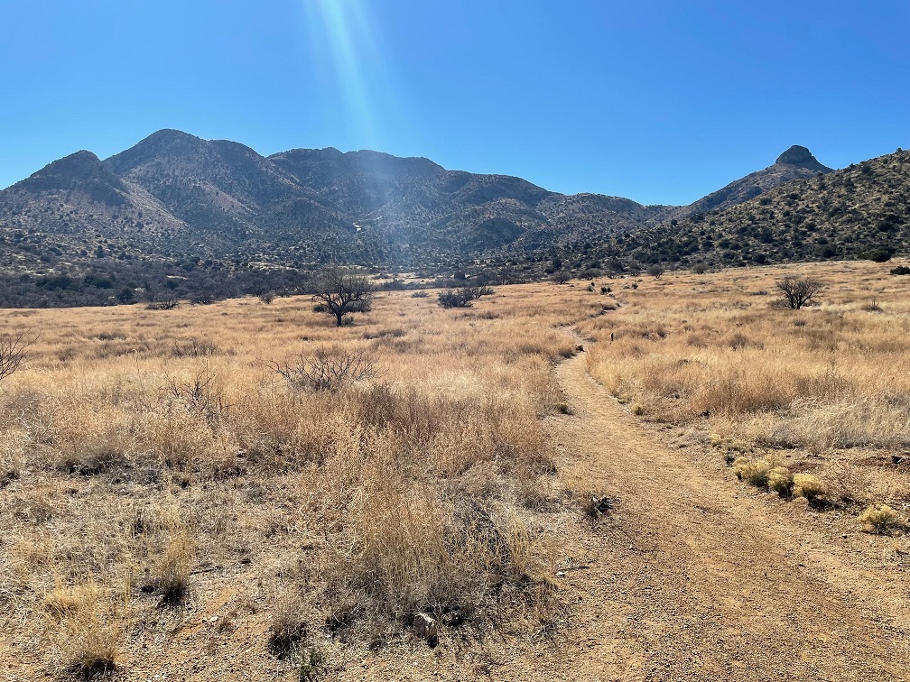
The drive from the monument’s visitor center to Massai Point, one of the monument’s higher points and the location of a number of hiking trailheads, gives an idea of the nature of the rock pinnacles.
Chiricahua National Monument, established in 1924 about 35 miles southeast of Willcox, Ariz., was part of the Apache band’s homeland. Today it’s a federally protected area measuring just under 20 square miles in area containing forested slopes, incredible rock formations, and sweeping vistas of southeast Arizona. Nancy and I visited the monument on Feb. 13, 2022. Since dogs aren’t allowed on the monument’s trails, Gunther took a break from sightseeing for the day.
The monument’s rock formations are the result of eruptions 28 million years ago from the Turkey Creek Volcano, the 12-mile-wide caldera of which is in the mountains on the horizon 10 miles away from this viewpoint. This photo was taken from Massai Point, looking to the southeast.
Perhaps the monument’s most famous features are its rock columns, resulting from a series of volcanic eruptions that occurred 27 million years ago from a magma chamber south of the present monument. During the eruptions, immense quantities of water vapor, carbon dioxide, and molten rock were thrust into the atmosphere. Other eruptions caused flows of gas and ash to flow down the volcanic slopes at speeds of up to 100 miles per hour. When the eruptions subsided, more than 1,200 square miles of land was covered with thousands of feet of ash. The deposits, called tuff, compressed and cooled over the ensuing years to form a rock called rhyolite.
This view, to the northwest from Massai Point, includes the large rounded mountain at right-center called Sugarloaf. At 7,310 feet, it’s the tallest accessible point in Chiricahua National Monument. Sugarloaf has thick layers of fragmented rock capped with hard lava. It might be hard to imagine, but all of the rocky area 2,000 feet below Sugarloaf was once a solid layer of rock all at the level of the top of that mountain. A variety of erosional actions, some more active than others, over the 28 million years since the eruptions have caused the lowering of the elevation and the fantastic carved rock columns. There’s a fire lookout, staffed during the hottest months of the season, at the top of Sugarloaf.
This is a mountain called Cochise Head, from a viewpoint looking northeast from Massai Point. It’s said to resemble the rugged face of a Chiricahua lying on his back. Fort Bowie National Historic Site, which we visited the previous weekend, is just on the other side of this rock profile.
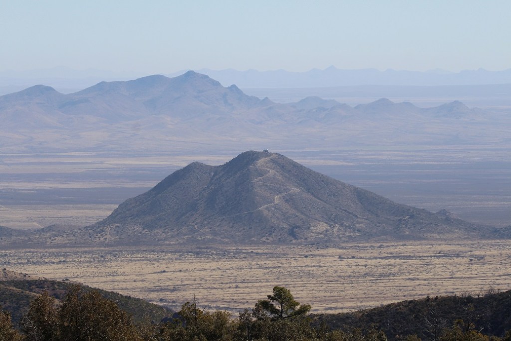
Here’s a view to the northeast of Massai Point, with Harris Mountain in the middle of the wide desert San Simon Valley. The Harris family had been part of a wagon train moving west in 1873. The family attempted to take a shortcut through these Chiricahua Mountains and disappeared. Several years later, soldiers from Fort Bowie found one of the Harris girls in an Apache camp in Mexico. The girl related the story of a Native American attack and led the soldiers to the spot at Harris Mountain where the rest of her family had been killed. The soldiers found the bones of the Harris family and buried the remains.One last image from Massai Point: this is another view to the southwest. We were fortunate to visit on a clear day, because we could see the location of Cochise Stronghold (a sanctuary for the Chiricahua chief and his final resting place) 40 miles away, as well as Rincon Peak (elevation 8.482 feet) and Mica Mountain (elevation 8,666 feet) in Saguaro National Park near Tucson (which we’d visit in a few days after Chiricahua National Monument). The 23-mile-wide Sulphur Springs Valley is between Chiricahua and the closest mountains.
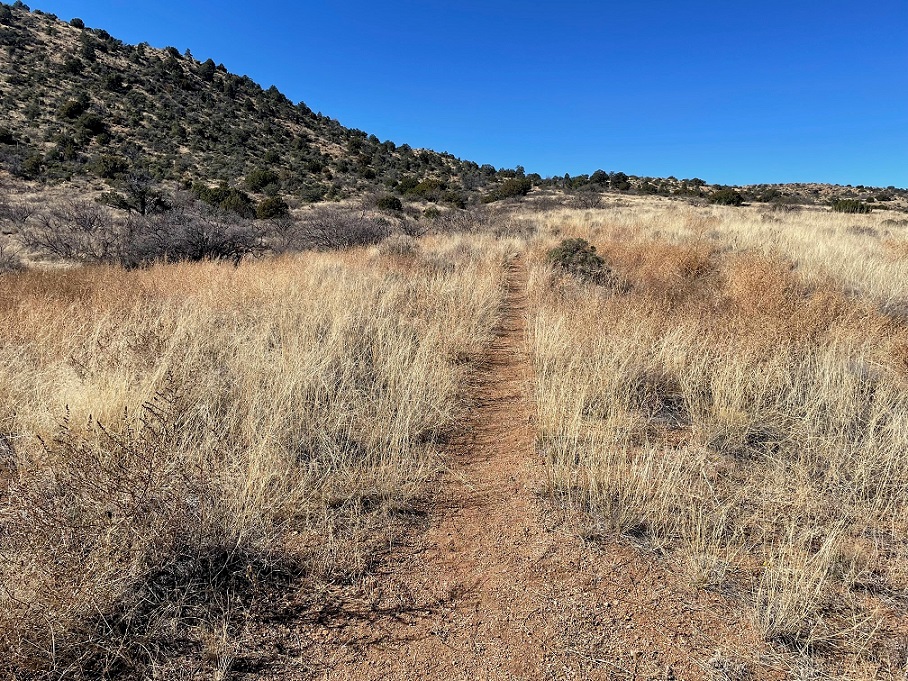
Let’s get back to rocks: the pinnacles in Chiricahua National Monument are formed by erosion. Cooling and uplift of the rocks formed cracks and joints in the tuff. Over millennia of weathering from ice wedging and water erosion, the cracks widened and weaker materials washed away to leave spires of rock. Here’s an interactive exercise: hold up your hand in front of you with your fingers straight and close together (go on: it’s fun!) Imagine that your closed fingers are a wall of volcanic rock, with your fingers separated by joints in the rock. Now slowly separate your fingers, as millions of years pass and countless freeze and thawing cycles of ice, as well as other erosional actions, wear down the rocks between your digits. Congratulations: you’ve created rock spires – told you it was fun.
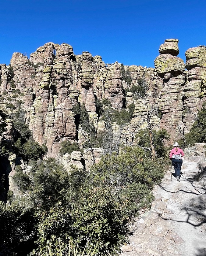
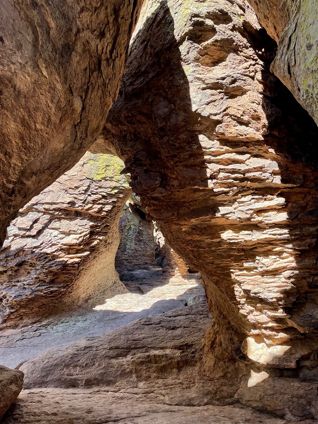
The pinnacles were later smoothed by wind, chemical action, and further water freezing and thawing over the last 10,000 years to their smooth and rounded shapes. Here we see an intrepid hiker (it very well be Nancy) making her way toward the columns on a trail called the Echo Canyon Loop.
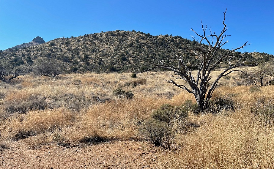
We went on a 5-mile loop hike from Massai Point that dropped about 1,000 feet into Echo Canyon. It was an incredible hike that allowed us to walk among the pinnacles, as well as see wonderful views and a variety of plants and wildlife.
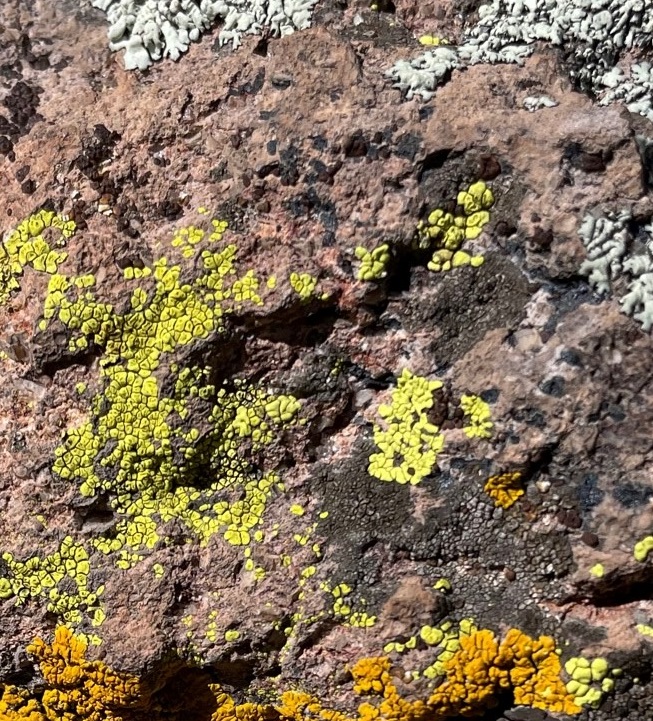
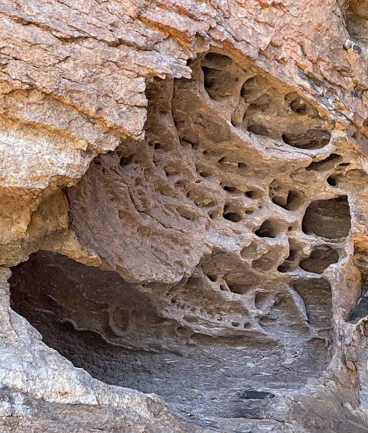
When the flows of hot ash settled to the earth, the heat they contained, combined with the immense pressure of layer after layer of ash, welded the material into solid rock. That welding action wasn’t always enough to transform the ash into solids; some layers cooled too quickly to weld together, and remained softer than other areas. There’s a hiker (in purple on the left) behind this column to give a sense of scale; also note the evergreen shrub growing out of the top of this column. Many years ago, the seed of that shrub was dropped into a crevice in the top of the rock (perhaps by a bird or a breeze); the seed germinated and the roots of that growing shrub are now helping to expand the crevice even further. We saw many cases of that happening: grasses, shrubs, cacti, and trees, growing in loose material in rocks and those plants’ roots helping to slowly but surely break those rocks apart, especially as rainfall and snowmelt freezes and expands in the crevices.Those layers in the rocks are seen in this photo. Also note the green material that’s on the rocks (and seemingly every other rock in the monument).Here’s a closeup of that green material: lichen, along with several other different-colored varieties. Lichen, too, is an erosive factor for rocks. Lichen is a plant-like composite organism (but not a plant) that attaches to rocks and organic materials like tree trunks. In their very slow growth cycle, they release weak acids that contribute, day by day over the centuries, to the breakdown of rocks.There are about 20,000 species of lichen in the world, and there are at least four of them in this picture. I have a hard enough time remembering how to tell sparrows apart and I’m not about to try learn how to identify lichen (but I like ’em)!
We got a really good sense of just what nature is capable of doing, given enough time, during this hike. I was especially struck by how some rocks have broken off, through erosion, from their original formations but didn’t end up on the ground.
Check out the placement of the rocks at the top of the column on the left: the larger rock at the top right of the column is probably seven or eight feet long. There’s no way these were placed by people.It’s just crazy.
There were other types of erosion on view as well. Running water can be an incredibly effective factor for erosion, especially given enough time.
This is a rock formation on the trail called “The Grottoes.” The smooth sides of the rock walls in the center of the photo were created by year after year of water running through the opening.Check out this weathering in the solid rock. A helpful passerby (again, most likely Nancy) provides a sense of scale; like most thoughtful hikers, she’s not actually touching the rock so that others can enjoy this formation for years to come.Again, just fascinating. I wonder if this and the previous formation were formed by softer materials being caught in the ash flow before it solidified, and then wearing away before the surrounding rock could.
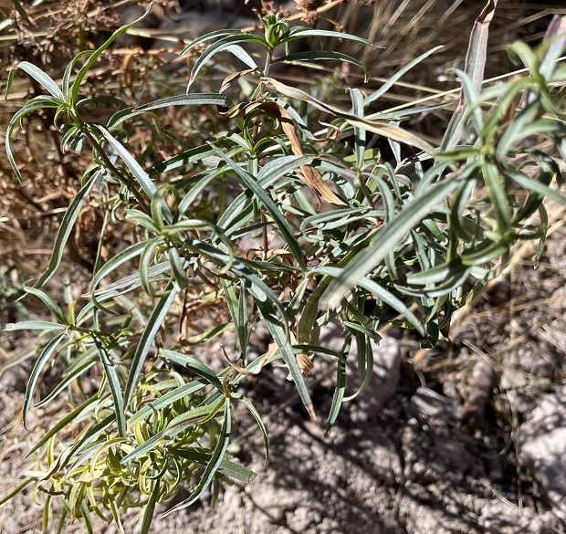
There’s more to enjoy in Chiricahua National Monument in addition to rock formations. The only wildlife we saw was a chatty acorn woodpecker and some acrobatic swallows swerving through the rocks, but we saw a good variety of plants. The varying topography and elevations in the monument lend themselves to supporting a wide variety of trees, shrubs, and other plants.
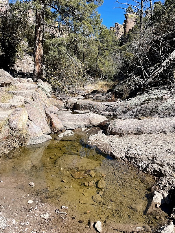
Here are two species of oak trees growing just a couple of feet apart from each other along the Echo Canyon Trail. The one on the left is netleaf oak (Quercus rugosa) and on the right is silverleaf oak (Quercus hypoleucoides). With enough water, silverleaf can grow up to 60 feet tall. That’s not happening in this desert canyon; both of these were two-feet-high shrubs.This is narrowleaf four-o’clock, a wild close relative of the four-o’clock annual plant that’s popular in gardens. Four-o’clocks have been cultivated since the time of the Aztecs. I think we were a bit too early to see it in bloom.Here, though, is a plant in bloom. This purple prairie verbena was attracting a large black butterfly that wouldn’t stay still for a picture.This is a very common type of cactus called strawberry hedgehog, growing in a rhyolite crevice along the trail. It has pretty fearsome spines.This was an extraordinarily rewarding hike. We seemed to stop every few paces just to enjoy the formations and views.We were a little surprised to see this good-sized spring at about the halfway point of our loop hike. It provided a little rivulet of running water further downstream.Just another example of nature being absolutely wild sometimes. This is a formation of rocks alongside part of the hike called Hailstone Trail. I’d love to find out how these rocks were formed, as well as some of the other atypical formations earlier in the hike. We had a blast at Chiricahua National Monument and will definitely return to get those answers.
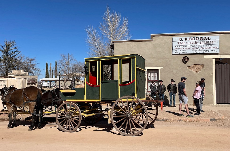
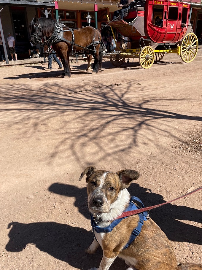
Tombstone is about the same distance from Willcox, Arizona, and from Tucson, the next city we stayed at in Arizona. We decided to make it a day trip from our campsite in Willcox. Neither of us had been to Tombstone before, and Gunther hadn’t, either, so we brought him along.
Tombstone started out as one of thousands of mining towns in the western United States, but it, of course, became famous for its lawlessness. Unlike the majority of those mining towns, it’s still around: precisely because of its reputation dating back to a gunfight 140 years ago that lasted perhaps 30 seconds.
Nancy and I were both rather surprised to see how many people had the same idea as us: there were more people on the streets of Tombstone than we’d seen in a couple of months. Because of the pandemic, we didn’t venture inside any of the buildings but enjoyed a pretty day on Tombstone’s streets.
This is the site of the Oriental Saloon, which was opened in 1880. Wyatt Earp (who wasn’t a marshal at Tombstone; he was deputized by his brother Virgil at the time of the famous gunfight) owned a share of the gaming tables in the Oriental. The original building burned down in an 1881 fire, but the Oriental was rebuilt quickly – just in time to be threatened by a larger fire in 1882. However, the building survived that threat. The Oriental became a drug store when Arizona adopted statewide prohibition in 1914, and has been home to a number of other businesses since then.
Tombstone was founded by Ed Schieffelin, who was briefly a scout for the U.S. Army. Schieffelin spent his free time searching for mineral deposits in the area, looking to strike it rich. The story goes that a friend told Schieffelin that the only rock he’d find would be his own tombstone. In 1877 Schieffelin did indeed find a significant vein of silver not far from the present location of the town; he named his mining claim “Tombstone,” and the name became attached to the town. Other miners were attracted to the area, and by the fall of 1879 several thousand people were living in canvas tents on top of the richest silver strike in Arizona’s history.
The first permanent buildings of Tombstone, no different from most boomtowns in the American West, were largely constructed from wood. As was the case with many of those towns, significant fires took their toll. What that means today is that very few of the most famous structures in Tombstone are the actual buildings dating from the 1880s. The first major fire occurred on June 22, 1881, and destroyed 66 businesses in the eastern half of the town’s business district. Less than a year later, a large fire on May 25, 1882, destroyed more than 100 businesses in Tombstone, including the O.K. Corral.
Unlike many buildings in Tombstone, the Bird Cage Theatre is original. It was built in 1881, and, after the fire that year, was one of only two theaters in the town. It operated as a first-class variety theater, bringing professional entertainers to Tombstone. It closed as a theater in 1892 and was, for many years, a museum.This is the site of the famous gunfight that occurred Oct. 26, 1881. It was a vacant lot near, but not in or at, the O.K. Corral. The gunplay, part of a simmering feud that involved politics and families, involved Deputy U.S. Marshal Virgil Earp, his brothers and temporary deputies Wyatt and Morgan, and Doc Holliday, versus the Clanton and McLaury families. The Earp family left Arizona in early 1882. There are at least two different recreated gunfights in Tombstone. It’s our understanding that the town used to have recreated gunfights in the street, but those are no longer conducted: everything’s inside a building now, and a paid ticket is needed.
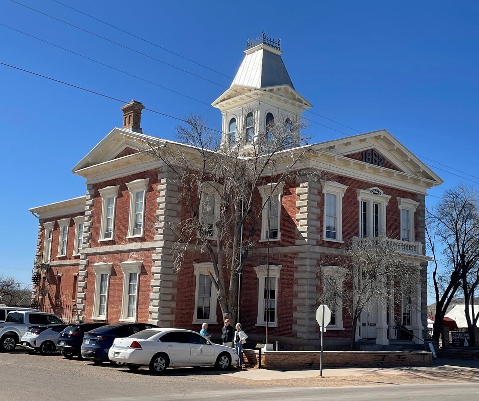
At the height of the silver boom, Tombstone had a population of about 10,000 people. It was a very wealthy city, and could offer world-class entertainment and foods that were impossible to find elsewhere in the West. By 1881, there were four churches, three newspapers (including the gloriously named “Tombstone Epitaph”), two banks, and 110 saloons. After the mining claims played out, Tombstone’s population dwindled to the point that it nearly became a ghost town. Only the fact that it remained the seat of Cochise County saved it from disappearing completely. In 1929, the citizens of Cochise County voted to move the county seat to Bisbee, about 20 miles south of Tombstone.
This is the Cochise County Courthouse, which was completed in January 1883 at a cost of $43,000. After the county seat was moved to Bisbee, an effort was made to convert this building to a hotel but that project was never completed. The city donated the building to the Arizona State Park Board in 1959, and the former courthouse because Tombstone Courthouse State Historic Park in 1960. A sign near the building states that the eaves on the courthouse serve as homes to colonies of Mexican free-tail and big brown bats. Their droppings, however, destroy the wood of the building. Arizona State Parks is working to exclude the bats from the courthouse, but any measures to do so must allow the bats to leave without allowing them to return, and, because of the historic designation of the building, can’t permanently alter the courthouse.
Today, Tombstone is definitely devoted to tourism. About 450,000 people visit this small town each year – that’s almost 350 visitors for every resident of Tombstone (current population: 1,300). For perspective, 42 million people visited Las Vegas, Nevada, (current population: 642,000) in the pre-pandemic year of 2019, which is 65 tourists for every Las Vegan.
Tombstone has several horsedrawn coaches going up and down its streets. As soon as we approached the street, Gunther started barking at the horses – we didn’t realize until then that he’d never been close to one. He calmed down after a while, and toward the end of our visit was fine with being around his new horse friends.
Our trip to Tombstone was enjoyable enough. It certainly gave Gunther an opportunity to expand his horizons a bit; I don’t think we’ll return, but we’re glad we went.
13 miles south of Bowie, Arizona – February 6, 2022
Apache Pass is a natural low geologic divide in southeast Arizona separating the Dos Cabezas (Spanish for “two heads”; see more below) Mountains from the much larger Chiricahua (pr. “cheer-uh-cah-wah”) mountain range. Apache Spring, a year-round source of flowing water near the pass, is the main reason many thousands of people traversed the pass beginning in 1848 through the end of the U.S. Army’s conflicts with Native Americans in the mid-1880s. Horses and people needed water to keep moving, and Apache Spring was the only dependable source of water for many miles. From the end of the Mexican War in 1848 through the end of the Apache Wars (1862-1886), Apache Pass provided a corridor for travelers between El Paso and Tucson. Once the southern route of the intercontinental railroad was completed in 1880, the pass became less important for travelers and commerce since trains weren’t as dependent on water as horses were. Until then, Apache Pass was an important point in the expansion of the American west: many thousands of people and great tonnages of goods found their way to the West by traversing the pass.
Chiricahua Apaches lived in this area for many years prior to other cultures entering the Apache Pass region. The pass was identified by both Spanish and, later, Mexican forces during their respective control of the area in the 18th and early 19th centuries.
Many Anglos first used Apache Pass on their way to the California gold fields in 1849. In 1858, the U.S. Congress authorized the development of an overland mail route, operated by the Butterfield Overland Mail Company. In operation between 1851 and 1861, the Butterfield route took advantage of Apache Spring to water its horses.
Apache Pass was also the site of the Bascom Affair, a conflict between Chiricahua leader Cochise’s band of Apaches and the U.S. Army in 1861. The Bascom Affair was the beginning of a decade of conflict between the Chiricahua and the Army, and led to the development of Fort Bowie to protect travelers using the pass and spring.
In 1872 the U.S. government struck a peace accord with the Apaches, establishing the Chiricahua Apache Reservation. For four years things went pretty smoothly, but the Apaches began to flee the reservation and conduct raiding parties into Mexico; the military presence in the pass subsequently increased. Geronimo eventually surrendered to the Army in 1886. Between the removal of the Native Americans and the completion of the railroad, the need for the U.S. military in the pass disappeared. Fort Bowie’s last garrison left the fort in 1894.
Fort Bowie National Historic Site, declared a National Historic Landmark in 1960 and located about 35 miles from Willcox,, preserves some of the building ruins and other features of a U.S. Army outpost built in the 1860s to protect travelers using Apache Pass from Native American attacks. In addition to fort ruins, this 1,000-acre site also features a number of other interesting historical areas, all of which are accessible by a 1.5-mile hike from the parking lot to the site’s visitor center.
Nancy and Gunther and I visited Fort Bowie National Historic Site in early February. It was an immensely rewarding experience, from both a historical perspective as well as a natural history view.
The site is unique in that visitors are encouraged to hike 1.5 miles to the visitor center rather than simply driving to a visitor center parking lot and then hiking from there; it’s certainly possible to drive to the center and park, but you’d miss out on a lot of natural and historical points of interest.
One of the first historic stops on the trail is this view of the camp site for a survey party led by Lt. John Parke of the Topographical Engineer Corps in March of 1854. The party, searching for an all-weather route for a transcontinental railroad, had marched 55 miles through the desert prior to reaching Apache Pass and the spring. The men rested at this spot for two days, enjoying both easy access to water and the companionship of the then-friendly Apaches. Parke would find an easier route for a railroad to the north of the pass, and the rail line was completed in 1880. The route, which passes between present-day Willcox and Bowie, is still in use today; there was puh-lenty of railroad traffic passing through Willcox while we stayed there.
The Bascom Affair
The next significant event, from an Anglo perspective, in the Apache Pass region occurred in January, 1861. A boy named Felix Martinez Ward was kidnapped by Apaches when the Native Americans raided the Ward family ranch. Lieutenant George Bascom was put in charge of the U.S. Army’s effort to find the boy. Bascom arrived in the Apache Pass area on Feb. 4, 1861, with a detachment of 54 men and camped in the area shown above. Cochise, the famous Chiricahua Apache chief, was invited to meet with Bascom. The young lieutenant accused Cochise of kidnapping Felix Martinez Ward, and Cochise denied the claim. Nevertheless, Bascom ordered that Cochise and his party be held hostage.The Bascom camp was just on this side of the hill shown above. Cochise escaped from the tent in which he’d been held and ran up the hillside. Cochise used a knife that he’d hidden to cut through the tent’s fabric; Cochise’s action is still remembered as “Cut the Tent” by the Apache today. The other Chiricahua, including members of Cochise’s family, were recaptured by U.S. forces. Bascom moved his detachment to a stage station nearby and fortified that building, apprehensive about what might occur during the night.These are the ruins of the Butterfield stage stop where Bascom and his soldiers sought refuge. Built in July 1858, the station had walls that reached up to 8 feet high. The morning after Cochise escaped, Apache warriors approached the station and told Bascom that Cochise wanted to talk. The meeting progressed for about half an hour before ending abruptly; one of the station workers had been captured by the Native Americans. Shots were fired and in the following weeks Cochise took more captives, attempting to exchange them for his family and other warriors held by the U.S. Army. Those talks failed as well, and Cochise killed the hostages; the Army retaliated by killing the Apaches in their custody.
The Bascom Affair ignited more than 20 years of conflict between the Chiricahua Apache and the United States government. Significantly, Felix Martinez Ward had indeed been kidnapped by Apaches but not by Cochise’s Chiricahua. He was raised among the White Mountain Apache and, as an adult, became a scout and interpreter for the U.S. Army.
The Butterfield Overland Mail route passed through the center of the area shown in this photo (I think the trail is a modern hiking one, not a remnant of the stage trail) and passed by the stage stop. In 1857, the U.S. government awarded John Butterfield a contract to carry mail between St. Louis and San Francisco. The stage coaches took 25 days to complete the 2,500-mile route. The Chiricahuas permitted the passage of the stages for two years; in exchange for gifts, the Apaches provided firewood for the stage station. Butterfield used smaller mule-driven coaches for this mountainous stage of the route, as opposed to larger horse-driven coaches on either end of the line.
The company received $600,000 per year to carry the mail between St. Louis and San Francisco. Butterfield started with 2,000 employees, more than 250 coaches, nearly 2,000 horses and mules, and 240 stage stations along the route.
After the stage stop ruins, the next stop along the trail is the post cemetery for Fort Bowie.
The cemetery actually predates the fort, as some U.S. Army soldiers were buried here in 1862. In addition to soldiers, the cemetery held the remains of the soldiers’ families, civilians, emigrants, mail carriers, and three Apache children, one of whom was Geronimo’s two-year-old son. About a half-year after the closure of Fort Bowie, most of the remains were reinterred at the San Francisco National Cemetery. However, the graves of 23 civilians are still here.
The next significant stop on the trail to the visitor center is the ruins of the Chiricahua Apache Indian Agency.
Cochise died of natural causes in 1874 on the Chiricahua Reservation. Before his death he’d befriended a U.S. Indian agent named Thomas Jeffords, who governed almost a thousand Apaches from this agency from 1875-1876. The U.S. government removed Jeffords from this agency in June 1876 and relocated 325 Apaches north to the San Carlos Reservation. Many of the Chiricahua fled the reservation, however, and resumed hostilities with Anglos that would continue for another decade. The ruins of this agency were excavated in 1984. The building had three rooms, each with its own fireplace, and wood floors. National Park Service conservators have stabilized the ruins with plaster to slow their erosion; an ill-behaved dog at right provides a sense of scale.
A recreation of an Apache camp is a little ways further down the trail. The surrounding area, although rocky and mountainous, provided everything that the Chiricahua needed to make their home here: water from Apache Spring, wild game, edible plants, and materials for building shelter, weapons, and tools. The Chiricahua culture centered around the wife’s extended family; after marriage, the husband entered into the family and committed to supporting his wife’s relatives. While the men hunted and participated in raiding expeditions, the women maintained the wild food crops.
The camps consisted of small groups of several wickiups, built from a pole framework and covered with long grass and animal hides, like this one. Because of inconsistent food supplies and threats of enemy attack, the camps were not permanent and the Apaches moved often. Here we see a big baby absolutely terrified of what unimaginable horrors might wait in the dark depths of the wickiup recreation (there was nothing, as it turned out), accompanied by Nancy.We got Gunther as an eight-week-old puppy in early November 2019, just a couple of months before the pandemic started, so he grew up in the last couple of years not having a whole lot of exposure to new experiences. For instance, we were made to realize he’d never been very close to horses when we went to Tombstone a few days after this hike. Once he gets used to new things, he’s generally okay with them. He gets along great with other dogs and people (and horses, once he’s seen one). He’s a really good dog, although I think he prefers hikes that have a lot more walking and a lot fewer opportunities to learn about history than this one did.
The Battle of Apache Pass
In mid-July, 1862, a guard of about 100 California Volunteers marched through Apache Pass toward the San Simon River in order to build a supply depot in that area. When the column approached the Butterfield stage station, which had by then been abandoned, it was attacked by Cochise, his ally Mangas Coloradas, and about 150 Apache warriors. The Californians drove the Apaches into the hills shown above, only to find that the Native Americans had taken up new positions around Apache Spring. After another attack, the Californians finally reached the spring and drove the Apaches away once again. The Battle of Apache Pass, July 15-16, 1862, led to the establishment of Fort Bowie.
We were on this trail in early February and were plenty warm; I cannot imagine what it would have been like to engage in battle with Apaches in mid-July, and while trying to fight your way to water.
Apache Spring
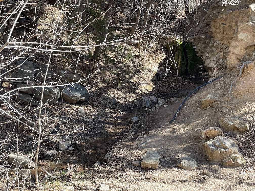
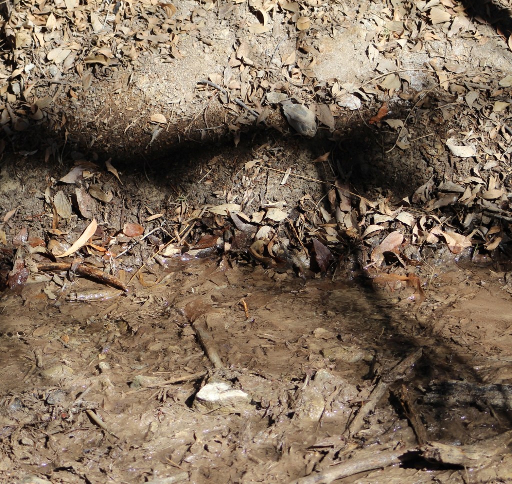
This is what all the deadly fighting over the decades at this site was about: Apache Spring, the only year-round source of water in the region. Archeologists have found pottery fragments around the spring that suggest the Mogollon Native Americans were here many years before the Apache came to this area.Apache Spring averages a flow of about 5 gallons per minute, but that can vary significantly depending on the time of year and recent precipitation amounts. It’s not a big outflow, but it’s wet and that’s all that matters. This little rivulet a few yards from the mouth of the spring is about a foot wide. Fort Bowie is a quarter-mile further down the trail.
The First Fort Bowie
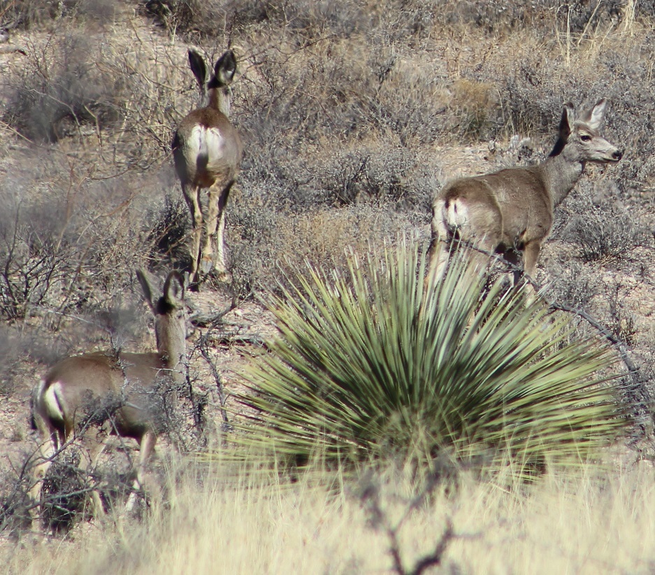
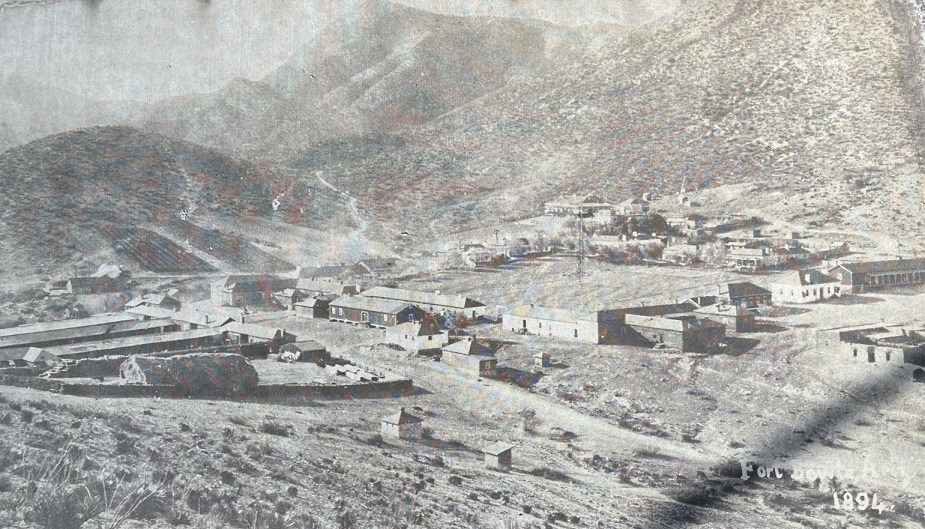
A 500-yard spur from the main hiking trail leads to these ruins of the first Fort Bowie. Construction started in July 1862 following the Battle of Apache Pass and the U.S. Army’s control of Apache Spring. A 100-man detachment of the 5th California Volunteer Infantry, under the command of Col. George Washington Bowie, completed the fort in two weeks. Incidentally, this instance of “Bowie” is pronounced “BOO-ee,” not “BOH-ee.” Also, that tree growing in the middle of the ruins is a catclaw acacia (Acacia greggii). Its Apache name is “ch’il gohigise,” which means “a bush that scratches you.” It has very sharp and claw-like thorns, but its seed pods were a significant food source for the Apache and they used the wood to make furniture and drumsticks. Bees are attracted to the catclaw’s blossoms and make a very distinctive honey.Although the Apaches didn’t control the water at Apache Spring any longer, they continued to attack travelers that weren’t being protected by the U.S. Army as they traversed Apache Pass. This first fort was only in use for six years as the California Volunteers pursued the Apaches with little success. It was apparently not an enviable duty post because of the extraordinary isolation, constant illness, poor living conditions, and consistent threat of Native American attack. I’d think, however, that the original builders would be pleased to know that the walls they constructed are still standing, in the heat of the Arizona sun, 160 years later. Regular U.S. Army soldiers relieved the volunteers in 1866 and began construction of the new Fort Bowie, 300 yards northeast of this location.This picture was taken looking to the southwest of the hill on which the first Fort Bowie was built; I’ve indicated the locations of several stops on the trail. The location of Apache Spring is not in this photo; it’s to the right of the area shown in the picture. The prominent mountain in the background is Government Peak, elevation 7,556 feet.As we approached the visitor center, we encountered a herd of 10-12 mule deer about 100 yards away. They gradually made their way up the opposite hillside, blending really effectively into the rocks and brush of the area.This is the visitor center for the Fort Bowie National Historic Site. At the end of the 1.5-mile hike, it’s an impressive structure that overlooks the site of the second Fort Bowie, and has a wonderful wraparound patio with plenty of rocking chairs and benches from which to admire the view. The building contains artifacts from the fort and other items representative of military life in the late 19th century; we didn’t spend much time in the building because due to Covid concerns NPS was understandably limiting how many people could be inside at the same time. That’s what is left of the fort’s armory on the left side of the image, well removed from the original site of the fort itself.Like the Indian agency from down the trail, there’s not much remaining of Fort Bowie. The mounds you see in the middle foreground are walls of the fort’s buildings that have been covered in plaster by NPS conservators in an attempt to preserve as much of the original construction as possible. This picture is taken from in front of the visitor center, looking to the northeast.This is a picture of a picture of Fort Bowie from January 1894, at the height of its presence at Apache Pass. For a perspective, the angular hill at the top left of the previous photo is the same one at the top center of this one. The tall building on the right side of the photo comprise the commanding officer’s quarters and in front of that structure are the officers’ quarters. The hospital is to the left and up the hillside a bit from the CO’s quarters. The low buildings at left are the corrals and stables; behind those are the ice machine and steam engine. In total, there are about 38 buildings in this photo. With the Apache Wars ending after Geronimo’s final surrender in 1886, the Army occupied Fort Bowie for eight more years. The U.S. Army abandoned Fort Bowie nine months after this original photo was taken. Area residents stripped the wood from the buildings for their own uses, and all that was left were adobe walls.Here’s a view over the ruins looking southeast from the visitor center’s railed porch, where Nancy and I sat on rocking chairs while enjoying a picnic lunch. Gunther collapsed in the shade of the porch. Some of the fort’s ruins can be seen in the mid-foreground as light tan mounds. You may have noticed the prominent rock formation in the background in previous photos; it is called Helen’s Dome, elevation 6,376 feet. The granite peak is reportedly named after the wife of an officer at Fort Bowie, and served as an important landmark for travelers approaching Apache Pass.
After the visitors center, hikers can either retrace their steps back to the trailhead’s parking lot or use an alternate route that provides a different perspective on the surrounding area. We chose the latter.
This spectacular view shows the valley of the eastern approach to Apache Pass and the Peloncillo (Spanish for “little baldy”) Range, 35 miles away on the horizon, and just beyond those mountains lies the New Mexico/Arizona border.
We also decided to drive back to The Goddard by a different route, making a loop between Willcox and Bowie on either end. It gave us a chance to see some different country, and I’m glad that we did.
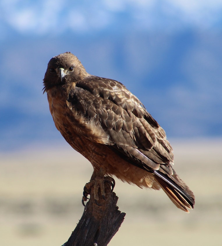
This is the rock formation that gives the Dos Cabezas (“two heads” in Spanish) Mountains their name. It doesn’t take much imagination to see faces in the rocks, especially the one on the left. This formation is about 15 miles due west of Willcox; it’s easily visible from the town (I enjoyed watching the colors of the setting sun on the formation while playing with Gunther in the campground’s dog run), but this perspective from the opposite side definitely shows you why it’s named what it is.We also passed this red-tailed hawk, perched on a roadside fencepost, on the way back to Willcox. It let me take five or six pictures before taking off. That’s snow-covered Mount Graham in the background, but from the opposite side of where we saw it while staying in Safford, Arizona.
We really enjoyed Fort Bowie National Historic Site. This was a “the journey is the destination” sort of experience — while it was interesting to see the ruins of the actual fort, the hike to those ruins, and the natural and cultural historic points we saw, was more rewarding. Hiking in the same paths that Cochise and Geronimo once walked, and learning more about the conflicts between the Chiricahua who lived here and the U.S. Army, is something that we’ll always remember.
If asked to name your favorite Rex Allen movie, which film comes to mind first? If you’re like Nancy and me, you’d probably be somewhat reluctant to name one, because you couldn’t name one. The simple truth is, we’d never heard of him. But, as we were to find out, we’d certainly heard him.
Willcox, Arizona, is the hometown of Rex Allen (1920-1999), known as “The Arizona Cowboy” as well as “The Last of the Silver Screen Cowboys.” Allen began his movie career as the public’s love affair with Westerns was turning away from the big screen and transitioning to the newfangled televisions in their living rooms.
The Rex Allen Museum opened in 1989 as a showcase for Allen’s career as a live performer, recording artist, actor, and film narrator. It has many of Allen’s personal belongings dating back to his childhood in Willcox all the way up to his Hollywood career.
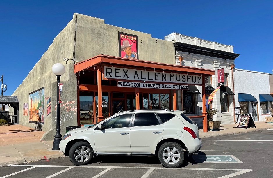
I finally managed to take a photo of a car parked outside a museum we visited (I don’t know why I didn’t just walk to the other side of the building and take a photo from there). The Rex Allen Museum is in one of the oldest commercial buildings in Willcox. The adobe building was constructed in the early 1890s and was later home to the Schley Saloon from 1897 to 1919. The museum still has the saloon’s original wooden floor. The Willcox Theater, next door to the museum, was built in 1935 and was where Rex Allen made his singing debut. Roy Rogers, later to be a friend of Allen, also sang at the theater early in his career.
Allen’s family homesteaded on a ranch about 40 miles from Willcox. He played guitar while his father fiddled for audiences in Willcox; after graduating from Willcox High School, Allen joined the rodeo circuit and toured the southwest.
Allen found life as a performing entertainer less painful than that of a rodeo star, and Allen got his singing career started at a Phoenix radio station. Soon after, he made his debut on a show called “National Barn Dance” on Chicago radio station WLS. This is the fiddle Allen used on the show. Note the tooled leather guitar case behind the fiddle.
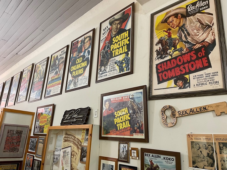
Allen would have a 35-year singing career with Decca Records, and had a gold record with his version of “Crying in the Chapel.” With singing cowboys such as Roy Rogers and Gene Autrey being very popular with moviegoers in the late 1940s, Republic Pictures signed Rex Allen to a contract in 1949. He would go on to star in 19 Hollywood movies, usually as a character with the very authentic Western name of “Rex Allen.”
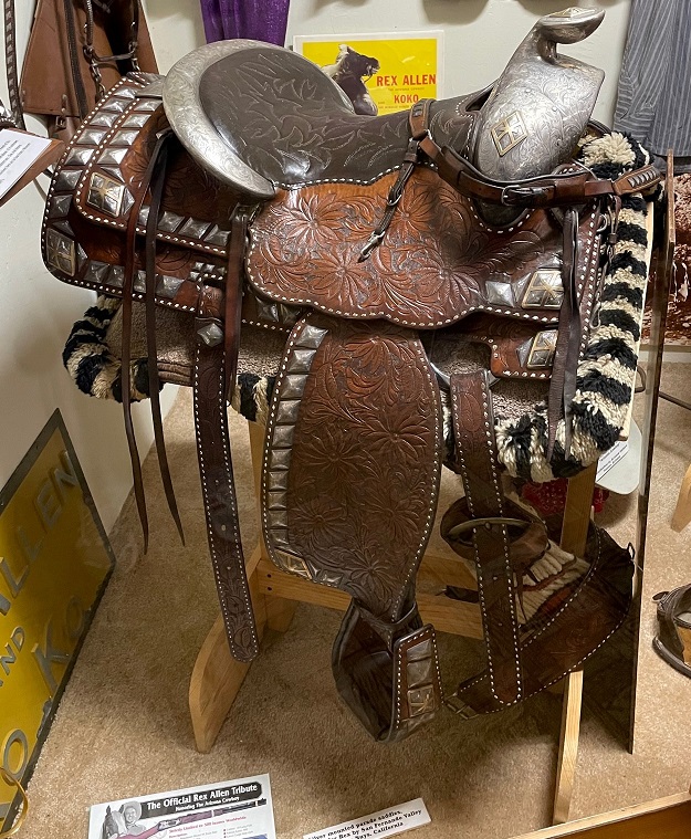
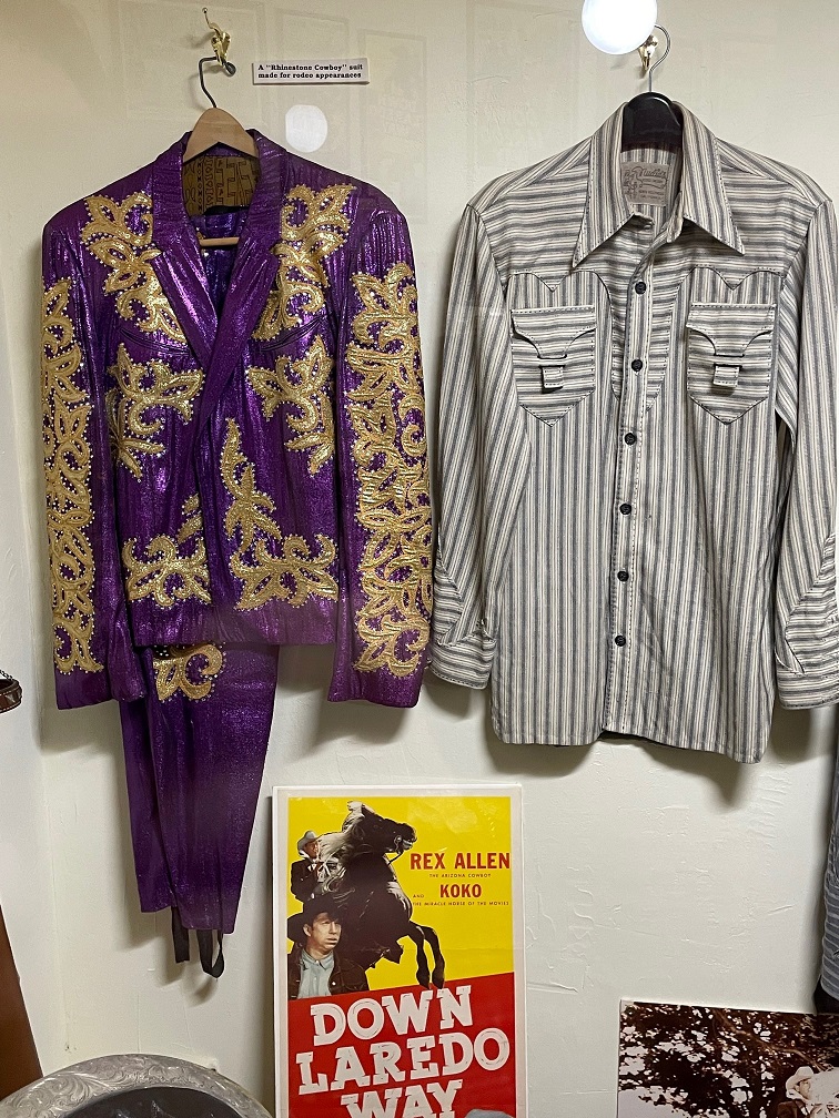
The museum has posters from many of the movies that Allen starred in between 1950 and 1954. Every movie cowboy needs a tremendously talented horse, and Allen’s was Koko the Wonder Horse. Koko usually received billing equal to Rex Allen in publicity for their pictures. Every movie cowboy also needs a sidekick; Allen was pardners with Buddy Ebsen and, later, Slim Pickens in various pictures.Allen was a top-ten box office attraction in his day, and his exploits carried from the big screen to other media like comic books. When you make it big as a Western performer, you get to wear Nudie suits: clothing made by Nuta Kotlyarenko, a Ukraine-born tailor whose professional name was Nudie. He made his mark making rhinestone Western-themed wear for both men and women. Nudie suits were worn by entertainers like Roy Rogers and Dale Evans, Hank Williams, Porter Wagoner, and Elvis Presley. The leather hat box in the lower right is also a Nudie design; it held Allen’s white Stetson while he was on tour.San Fernando Saddlery in Van Nuys, California, made this very pretty silver-mounted parade saddle used by Allen.On the left is another Nudie suit that Allen wore in parades. It’s pretty flashy. On the right is a custom-made shirt; note the closures on the chest pockets. Allen didn’t like buttons on his shirt pockets.This was an “a-ha” moment for me. Did you ever see those live-action Disney films from the 1960s and 1970s, particularly the ones set in the American West, that featured a very relaxing narrator’s voice that had just a hint of a drawl? Rex Allen was the narrator of movies like “Charlie, the Lonesome Cougar,” and “The Incredible Journey,” and more than 40 other Disney films and television programs. Allen’s voice was also that of 150 different Disney cartoon characters. His Western voice, instantly recognizable, narrated the animated adaptation of “Charlotte’s Web” (which was a Hanna-Barbera production rather than Disney).In addition to lending his voice to a number of television productions, Allen lent his likeness to promote Ford tractors, Purina animal feed, Tony Lama boots, and other products.Speaking of Tony Lama, here’s a pair of cowboy boots custom modified for use on the golf course. They’re next to an autoharp given to Rex Allen by June Carter Cash, wife of Johnny Cash.Speaking of Johnny Cash, here’s a wall of memorabilia featuring people who knew and worked with Rex Allen, including country music superstar Tanya Tucker (under the Man in Black’s illustration), who also grew up in Willcox, Arizona. Next to Tanya’s photo is a picture of John Wayne with Allen, and above that is a picture of The King, and to the right of Elvis is a signed photo of Ken Curtis, who played Festus Hagen in “Gunsmoke.” Speaking of “Gunsmoke,” Allen was a cousin of Glenn Strange, who played Sam the barkeep in Dodge City from 1961 to 1974.The museum building is also home to the Cowboy Hall of Fame. One of the Hall of Fame exhibits is this display of barbed wire dating from 1874 to 1884, so you know it’s okay in my book.
Willcox still shows a lot of love for its most famous native son. “Rex Allen Days” began in 1951 as an event benefiting the local hospital. It continues each year to this day, attracting Western film aficionados from around the world, and includes a rodeo and the annual Cowboy Hall of Fame induction. One of Willcox’s main streets is called Rex Allen Drive.
This larger-than-life bronze statue of Rex Allen is situated in a park directly across the street from the museum. Koko the Wonder Horse is buried nearby, and Allen’s ashes were scattered in the park upon his death. (The sun, as it is wont to do sometimes, wasn’t cooperative so the lighting isn’t the best.)
Between 1949 and the late 1960s, more than 100 different Western TV series aired on television networks – which was great for fans of “Gunsmoke” and “Have Gun, Will Travel” and “Wagon Train,” but not so good for stars of big-screen Western movies. Allen did star in his own short-lived TV series, “Frontier Doctor,” in 1961, but his time as a big-screen star was over. However, he continued to do very well doing off-camera work for Disney and other production houses.
After we visited the museum, Nancy and I could do little else than retreat that evening to The Goddard and watch a Rex Allen movie. We selected “Colorado Sundown” (1952), and do you know what? We liked it a lot. It had a pretty intriguing storyline and some great action crammed into its 67 minutes, and it gave an opportunity for Rex Allen to sing a bit as well. As of now, it’s our favorite Rex Allen movie. Honestly, we’d love to watch another one sometime.
After spending November and December 2021 and most of January 2022 in New Mexico, the Goddard made its way to Safford, Arizona, in late January, where we stayed for two weeks. Our first destination, not including a couple of very good Mexican restaurants in Safford and nearby Solomon, was the Eastern Arizona Museum in Pima, Arizona, which is a few miles west of Safford. The museum is located in the former Bank of Pima, which opened on May 19, 1916, with $30,000 in capital, as well as a couple of other adjoining buildings that were built separately but have since been connected. Like the museum in Deming, I neglected to get a photo of the exterior of this museum as well, but it’s an impressive building.
It’s hard to ignore the structure on the right: it’s pine bark that’s enclosing the museum’s office. I’m uncertain when, but some decades ago a Pima town employee used prison labor and the city’s dump truck to collect several loads of pine tree bark from the nearby Graham Mountains. They cleaned up the bark and then fumigated it under plastic to kill the insects, and then used the bark to construct display cases for the museum. In 1997 most of the display cases were remodeled like the ones on the left, but the bark remains around the museum’s office.
The town of Pima was founded on April 8, 1879, by a group of Mormon pioneer families on a site south of the Gila River (the same watercourse Nancy and I saw when we visited the Gila Cliff Dwellings north of Silver City, New Mexico, earlier in the month). The original settlers were joined later that year by several other families, and today the town has about 2,500 residents.
The museum has an impressive collection of Native American pottery and stone tools found in the area. It also features a wide variety of donated collections of tools, housewares, and other items dating back to the 1880s.
Here’s a large collection of old farm and ranch tools. Nancy noted that the person who wielded the sheep shears (to the right of the curry comb and bullet mold at center left) probably had impressive forearms. The shears date to the early 1900s.
Much of the museum’s collection is in a building called Cluff Hall, which is the oldest building in Pima. It has been connected to the former bank building just to its south as part of the museum. Moses Cluff constructed the building from limestone in 1882. It served as Pima’s cultural center, hosting plays, concerts, political debates, dances, and meetings of the Latter Day Saints (although it was never formally dedicated as a house of worship). The first kindergarten class in the Gila Valley was held in Cluff Hall in 1901, with tuition of five cents a day. In 1912, two immigrant brothers from Lithuania opened a clothing store but their endeavor was ended by the country’s entry into World War I a few years later. The two brothers later opened a department store in Safford that was in business until the 1960s. As with many old buildings, Cluff Hall was home to a huge variety of businesses and activities.
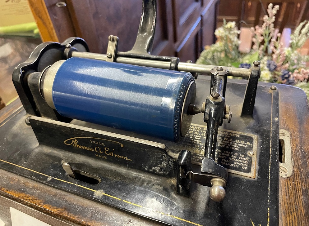
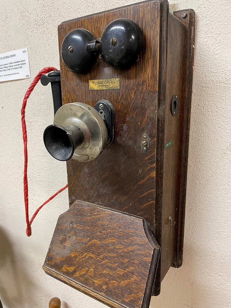
This bell, forged in 1890, was installed in a brick Latter Day Saints church that had been built in Pima in 1888. It’s perhaps two feet tall. A placard nearby has a recollection from 1981 of the bell by a resident of Pima, Laura McBride Smith, who was present when the bell was first rung 90 years earlier: “When that church bell in that building gave its first taps, I heard it. I climbed upon a big double gate where teams and people went in and out across the street west of the Pima Church house, and that is where I first heard the lovely sweet tones and it was first broadcast all over Pima. It was the first bell in the Gila Valley. It rang ’till the sun went down. It is something I have never forgotten. I am sure there isn’t another person alive today who heard that bell first ringing in 1891. Folks, its tone is just as sweet today as always, and to me, when this bell was poured hot in its case they poured a portion of ‘witchery’ into it and closed up the opening while hot and it could not get out and that ‘witchery’ potion will always be there. My children and everybody knew how much time they had to get to church or school the year around. What a blessing that old bell was to the whole community!”Any museum in the western United States worth its salt will have a display of historic barbed wire, and on this point the Eastern Arizona Museum does not disappoint. This case, about six feet tall, includes information about the manufacturer, style, and date of each example.I really like the simple burlap and wood presentation of this exhibit, which is located on top of the larger case seen above. I used to have a DYMO label maker when I was a kid – I never forgot what the things in my bedroom were called back then because everything was labelled.Still more examples of barbed wire from the 1870s and 1880s. Some of these styles look like they were quite a lot of work to manufacture, especially in the quantities needed to fence the American west. I’m just happy that everyone shares my appreciation of barbed wire.Let’s, with regret, set aside our examination of barbed wire for a bit. Here’s a phonograph that belonged to Thomas Hollis Dodge, who was born in Pima in 1897. This phonograph was the first one in the Gila Valley. The recordings on the wax cylinders didn’t have the names of the artists until 1910. As I’m writing this, I’m listening to music being transmitted into the Goddard from satellites positioned more than 22,000 miles above Earth and I have access to 95% of the catalog of human song recording, including the one on this blue cylinder if only we knew what it is. For now, I’ll have to be happy with “Be My Baby” (The Ronettes, 1963). And I am.The placard on this manual foot-pump organ states that it was purchased by Adiel Sanchez and Reyes Colvin Sanchez in 1915 and used many years in a church in Sanchez, a town about 20 miles west of Pima, and later used in their home. I love the wear marks on the pedals, and I’m sure the people playing this organ made beautiful music.The placard for this item notes that its first owner, W.W. Pace, “had to put up his own lines to have this telephone.” It’s one of the first telephones installed in Thatcher, which is a town just west of Safford on the way to Pima. Nancy’s family will note that this phone is a fine Western Electric product. I took all of these photos at the Eastern Arizona Museum with my phone, which doesn’t have the beautiful wooden construction of the model shown here.Here’s something I found really interesting: this is the wedding photo of Albert M. Haws and Alice Cluff Haws from October 30, 1911. They’re a very handsome couple. A trunk on the floor under the photo contains Alice’s wedding dress and clothes worn by some of their later children. The interesting part is …… next to the 1911 photo above is this program from the celebration of the couple’s fiftieth wedding anniversary on October 28, 1961. Albert and Alice were married for six years before the United States entered World War I, and celebrated their 30th anniversary a few months before the bombing of Pearl Harbor. They were married eight years after the Wright Brothers’ first powered flight at Kitty Hawk, and, a few months before their 50th anniversary, the Soviet Union and, later, the United States sent men via rockets into space for the first time. Still a very handsome couple, and I appreciated that the family shared its history with museum visitors.
The Eastern Arizona Museum is a great example of a community historical institution that continues to serve its community. There are plenty of resources for families with roots in the area to continue genealogical research, and there’s a huge variety of exhibits that nearly anyone will find of interest. And, as the Haws family shows us, museums can put personal family gatherings in the historical context of larger world events. Especially when the museums are in historic buildings, one has an opportunity to wonder about all of the people who stepped through those doorways in the many decades before, and who may have used the objects now on display: farmers, bankers, mothers, young students … what were their lives like in the 1890s or the 1910s or the 1960s? What made them laugh, and what made them stay up sleepless at night? We can all learn a lot from history, and great community institutions like the Eastern Arizona Museum are a perfect place to do just that.
President Theodore Roosevelt established Gila Cliff Dwellings National Monument in 1907 to protect ancient Native American-created structures in the Gila Wilderness of southwest New Mexico. It’s a fantastic destination for anyone interested in the history and culture of the southwest United States (and getting there is rewarding as well).
Nancy and I visited Gila Cliff Dwellings National Monument on a Sunday in mid-January. Because dogs aren’t allowed on the trail to access the dwellings, we decided to board Gunther that weekend. This national monument is very isolated: despite being only about 45 road miles from Silver City, New Mexico, the drive takes about an hour and 45 minutes because of a large number of extremely tight turns.
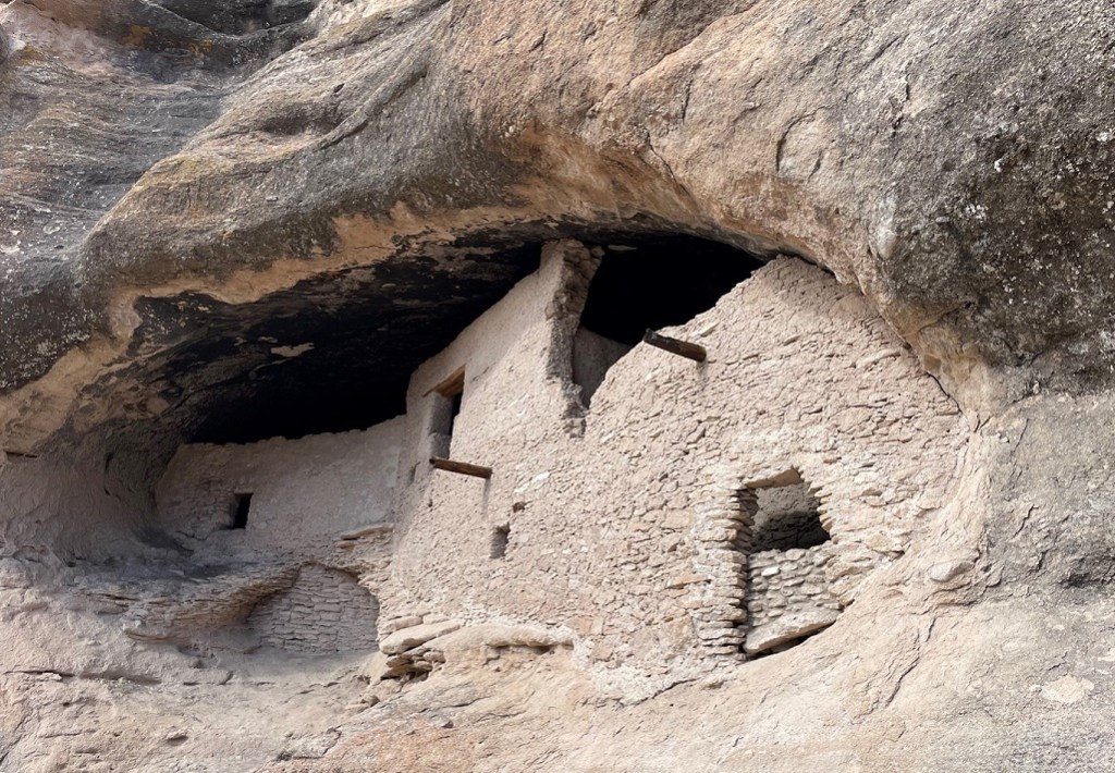
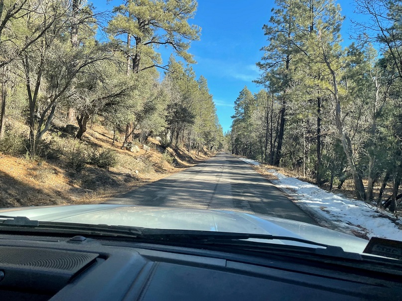
The road (part of The Trail of the Mountain Spirits National Scenic Byway on New Mexico State Highway 15) is paved and well-maintained, although we saw plenty of ice and snow along the roadside.The drive isn’t only through dense forests: there are also plenty of extraordinary vistas to enjoy. This is looking to the northeast from NM Highway 15. It’s at least another half hour to the monument from here.Due at least partially to the Covid-19 pandemic, the monument’s visitor center was closed (which we knew prior to leaving Silver City that morning). We proceeded to the trailhead that takes hikers to the dwellings themselves, but first stopped at a pullout to read about a 1966 excavation that uncovered evidence of nearly 2,000 years of consistent human habitation at this particular site. Evidence of a pithouse structure dating from the year 200 was found, along with other buildings from between 650 and 1000, as well as Pueblo rooms from the period between 1000-1300, and finally a relatively modern three-room adobe homestead dating to the year 1883. The highway on the right side of the photo, which leads to the cliff dwelling’s trailhead, was built in 1966 over some of the excavated ruins; the stone outlines in front of our pickup represent the location of the Pueblo structure dating from between 1000 and 1300. This site is just a few steps from the Gila River (to the left of this photo), so it had easy access to consistent water for all of those inhabitants over the centuries.The monument has a bookstore adjacent to the trail leading to the dwellings, and this American crow (Corvus brachyrhynchos) was hanging out on the bookstore’s roof. There was a time that I didn’t think too much of crows (the big park that we once lived next to in central Denver had a very large and vocal group of them), but I’ve since begun to appreciate them more. They’re very smart and adaptable birds. While Anglos tend to have negative connotations of crows, many Native American cultures view them with quite a lot of respect. I took this guy’s appearance before our hike as a positive sign, although it’s very possible he was just eyeing my pre-hike peanut butter and jelly sandwich.This is the trailhead view of the cliff where the dwellings are located, although the dwellings themselves are on the other side of the cliff and not visible from this point. The Mogollon Mountains, which include the Gila Cliff Dwellings National Monument, are located in the caldera of a supervolcano that erupted about 28 million years ago. The eruption, one of several that occurred at about the same time in the same area, had an explosive power 1,000 times that of Mount St. Helen’s eruption in 1980. The volcanic material fell to the ground and, because it was incredibly hot, welded together into a rock called tuff. Later volcanic eruptions covered the tuff with another type of volcanic rock called andesite. All of the ground level of this area was once near the top of the cliffs. Following the eruptions, millions of years of erosion by water, wind and other forces created the sedimentary stone that’s in this and other cliffs. Harder types of rocks at the top of the cliff keep the ground there from eroding as quickly as the softer rocks below. A creek flowing through the area gradually carved out a canyon, and also dislodged huge boulders to expand holes in the cliff that would become caves. About 700 years ago, the Mogollons built their dwellings in those caves.This is the West Fork of the Gila River, which starts a few miles just north of the dwellings and which one crosses over a bridge to begin the hike. The West Fork joins the Middle Fork of the Gila River a couple of miles east of this bridge near the monument’s visitor center, and they converge with the East Fork a few miles further downvalley. We’d see more of the Gila River in the weeks to come.The short hike, a one-mile loop that passes the dwellings, is one of the more pleasant ones Nancy and I have been on in a long time. It’s shaded by trees and by the walls of the steep canyon through which Cliff Dweller Creek, a year-round source of water that converges with the Gila River, flows. The canyon and surrounding area are home to a number of species of animals like deer, turkey, and javelina – all of which provided the Mogollon in their day with food as well as materials with which to build tools. Between the animals, the trees and plants, and the water of Cliff Dweller Creek (the Mogollons likely called it something else), the cliff dwellers had everything they needed to make a home.I regret not keeping count of how many bridges cross Cliff Dweller Creek on the way to the dwellings, but it was at least a dozen. Having helped build parts of quite a few trails, Nancy and I appreciated the work that went into developing and maintaining this one. Even though we were in southwestern New Mexico, we were glad we both had jackets for this hike – it was chilly in the shade.To wit: I thought the material on the canyon wall on the left was evidence of a popular place for birds or maybe rodents; as we walked closer I realized that it was frozen water coming from a spring that feeds the creek.After a very pleasant walk in the canyon, the trail rises gradually to provide this view (with a telephoto camera lens) of the dwellings. The person at the structure on the left provides a sense of scale; we were to find that she’s an National Park Service volunteer named Lena. The black streaks arising from the caves are evidence of human habitation: carbon from cooking and heating fires from 700 years ago and even further back. Soot on the cave ceilings indicates that humans lived in these caves for thousands of years before the Mogollon arrived and made improvements.
Archeologists believe, based on studying designs on pottery found within the ruins, the Mogollon people who built and lived in these dwellings originally came from the Tularosa River region, which is about 60 miles north of the monument. From dendrochronology that dates timbers used in the construction of the dwellings, researchers believe the structures were built between the years 1276 and 1287.
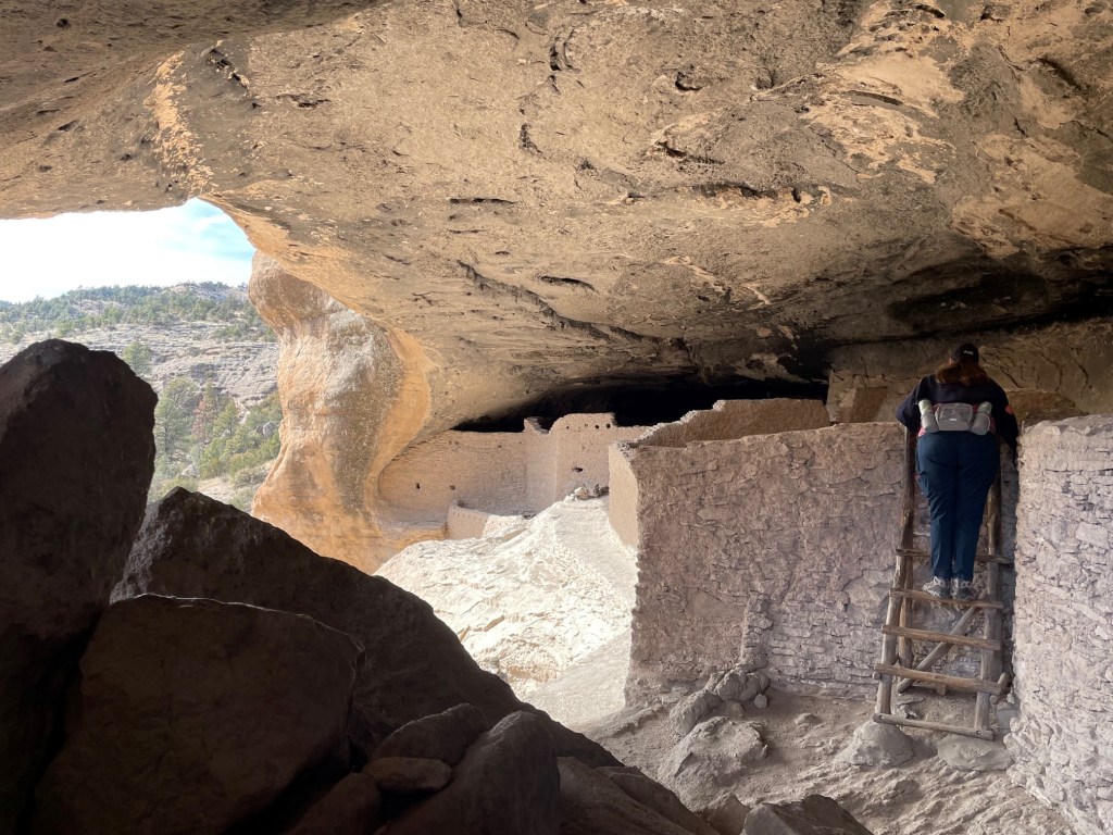
About 40 structures, ranging from large communal rooms to small storage areas, were built in five natural caves within the cliff. The dwellings provided homes for 12-15 families.Lena, the NPS volunteer, said that about 90 percent of the present-day dwellings is original; the rest has been work done by NPS to help protect and fortify the structures. It’s notable that walking around the structures within Gila Cliff Dwellings National Monument is permitted and encouraged; that’s not the case with all NPS cliff dwelling sites because of (wholly understandable) concern about destruction from human traffic. Nancy and I have really enjoyed visiting some of the more remote NPS locations in New Mexico and Arizona, in part because of the lack of crowds.This wood beam, or viga, is original to the cliff dwellings, and along with a series of other vigas and additional materials supported another floor above this room. The tree that the wood log came from was felled 500 years before the signing of the Declaration of Independence. I didn’t place anything next to it for a sense of scale (it’s 750 years old), but I’d say about 18 inches of the viga is protruding from the wall.Here is an intrepid researcher, from her tenuous perch high atop a wooden ladder, peering into the depths of one of the structures. What clues will she find as to what really happened? This is a view looking through the natural cave opening to the canyon wall on the other side of Cliff Dweller Creek below. The holes in the walls of the structure are where vigas were placed to provide support to another floor of the still-existing room.
Despite putting a lot of effort into the construction, the Mogollon lived in these dwellings for only a short time before moving southward in about the year 1300. While research continues to determine reasons for their departure, most evidence points to a widespread and prolonged drought that forced many Native Americans into larger communities in present-day northern Mexico.
Present-day Native Americans say that the Mogollon never left; their descendants became the Zuni and Acoma Pueblo tribes of present-day New Mexico and the Hopi tribe in present-day Arizona.
The Mogollon weren’t the last Native Americans to live in this area. Evidence shows that the Apache moved to the upper Gila River in the sixteenth century. The storied Apache leader Geronimo was born very near the cliff dwellings, at the headwaters of the Gila River, in the early 1820s.
Because of the nearly two-hour drive from Silver City, the largest municipality close to the dwellings, Gila Cliff Dwellings National Monument is not a destination one goes to by accident. However, it’s well worth the effort to get there, and we’re both looking forward to a return trip in the future.
True to its name, Silver City, New Mexico, was founded in the summer of 1870 by silver prospectors who’d found some mineral deposits in the area. Native Americans had been extracting minerals, including silver, copper, and gold, from the area for centuries, to be followed in later years by Spanish and Mexican miners. The silver deposits soon played out for the Anglos, but the town kept the name even as extraction interests turned to the prodigious amounts of copper to be found in the area.
And make no mistake: copper is now king in Silver City. The Chino Mine is 15 miles east of Silver City; it’s the third-oldest active open pit copper mine in the world. The Tyrone Mine, another open-pit operation, is 10 miles south of Silver City. Many residents of Silver City and the area are employed by the industry and references to the resource can be seen everywhere: the roofs of many houses and businesses are made of copper.
Copper has been taken from the ground for 10,000 years, but 95% of the copper extracted by humans has been done so in the last 100 years and more than half of that has been done in the last quarter century. That’s the impact of continually improving mining technologies and processing techniques. Those improvements will need to continue: there are vast stores of copper within a mile of the earth’s surface, but most of it is economically unfeasible to extract using current mining processes.
What’s the value in copper? Why do companies expend great effort and expense to dig it out of the ground? Copper has two qualities that make it extraordinarily useful: it’s malleable, and it’s a great conductor of both electricity and heat. It can be bent or twisted or flattened to whatever shape is desired, and then used to conduct electricity in power lines of all sizes or used to fashion cookware or rooftops. Forty-three percent of the copper produced in the United States is used in construction and 19% is used in electronics. Byproducts recovered from copper mining include molybdenum (which is an element used for hardening steel and other alloys of iron): almost half of the molybdenum produced in the United States is a byproduct of copper mining rather than mining for molybdenum directly. Seven percent of the gold produced in the country comes from copper mining.
Copper is, of course, also used in alloys with other metals to produce coins.
A few days ago, I was sorting through several collections of coins in the Goddard (we go through a lot of quarters to do laundry) and came across this 1942 penny. It’s 80 years old, and, although it looks like it’s seen some pretty heavy usage in the last eight decades, it’s held up pretty well because it’s made of metal. Pennies in general have an interesting history. The first pennies minted by the U.S. government, produced in 1787, were 100% copper and about half again as large as today’s coins. Shortly before the U.S. Civil War, in 1856, the composition changed to 88% copper; in 1864, the alloy changed again to 95% copper and 5% zinc. This is what the penny in the picture is made from. Because of the need for copper in the production of war materiel, pennies minted in 1943 were made of zinc-coated steel (and, because of their size and color, were easily mistakable for dimes). Coins returned to the normal production process in 1944. In 1982, the mint started using 5% copper and 95% zinc, and pennies made today are made with a base of 97.5% zinc and only 2.5% copper plating.
We spent the last month of 2021 and will spend the first few months of this year in the heart of the United States’ copper-producing region. New Mexico is the No. 3 copper-producing state, and Arizona is the No. 1 producer; 60% of the newly extracted copper in the country comes from the Grand Canyon State.
On January 9, we took Gunther on a tour by motor of the sights to be seen of present-day and historic copper mining operations around Silver City. The city has produced a handy printed guide with suggested stops along the highways and byways in the area.
Although it was a source of copper for centuries, the Chino Mine began operations as an open-pit mine in 1910. It was developed by mining engineer John M. Sully and entrepreneur Spencer Penrose. The latter’s name will be familiar to Colorado residents: he’s the same Spencer Penrose who made a fortune in gold mining and processing in Cripple Creek, Colorado, in the late 1890s. Along with tremendous profits from later copper processing operations in Utah, Nevada and Arizona, as well as New Mexico’s Chino Mine, he invested his fortune in Colorado Springs to build the Broadmoor Hotel and many other institutions in and around the city.
This is a Google Earth image of the Chino Mine (top right corner) and Tyrone Mine (bottom left corner) in southwestern New Mexico. Both are open-pit operations. Silver City is the gray area just to the left of top center. For scale, the short horizontal line at the extreme right bottom corner, in the black band, represents a distance of two miles. The campground we stayed at is just south of the Tyrone Mine; we couldn’t see it from our campsite, but we could see parts of it when walking Gunther around the campground.
Both the Chino and Tyrone mines have been owned and operated by a variety of companies since they were developed; the current owner of both concerns is Freeport-McMoRan, Inc. The Chino Mine has about 2,200 acres of reclaimed tailings (the rocks left over from excavation), while Tyrone has more than 4,000 acres of tailings and stockpiles.
This is a view of part of the Chino Mine, looking east – the mine’s many layers on which humongous ore haul trucks drive are in the middle third of the photo. In the upper third, just left of center, is a rock structure called “The Kneeling Nun” – it appears to be a figure kneeling toward the large monolith to the right. The huge monolith and The Kneeling Nun were formed about 35 million years ago from a volcanic eruption that resulted in about 220 cubic miles of tuff, which is volcanic ash that has solidified into rock. City of Rocks State Park, located between Silver City and Deming and which we’ll have to visit the next time we’re in the area, includes part of that tuff formation. The Kneeling Nun structure separated from the rest of the tuff monolith over the years to form the present-day figure.Here’s a closer view of The Kneeling Nun using my 300mm telephoto lens. Putting aside for a moment the volcanic eruption from 35 million years ago, the legend of The Kneeling Nun, or Santa Rita, is an important one to the residents of this part of New Mexico: briefly, some Spanish soldiers under the command of Coronado were moving through this area and one of the soldiers was badly injured in a battle with Native Americans. He was brought to a monastery near the present-day site of the mine where a nun, Rita, tended to his wounds. They fell in love, which was forbidden for both, and their relationship was reported by another jealous soldier. Rita asked for forgiveness but was condemned to death. She prayed to be turned into stone, and her wish was granted. Shortly thereafter, an earthquake destroyed the monastery and only the rock formation of Santa Rita remained. Santa Rita is the placename of a town adjacent to the Chino Mine, which also goes by the name of the Santa Rita Mine.This is a view of the Chino Mine from an overlook with informative displays about the mine’s operations. That’s the tire from a haul truck on the left. If you’ve never been next to a modern-day haul truck, just know that they are huge. The top of this tire’s opening – not the top of the tire, but the tire’s opening – is about six feet from the ground, and a quarter of the tire is set into the ground. In most mining operations, the trucks and excavation machinery are kept going around the clock to maximize efficiency. While we were at this overlook, a haul truck drove by on the road on the other side of the fence. We waved, and the driver honked his horn!
The Chino Mine was one of the operations where the processes of open-pit mining (as opposed to shaft mining) were first developed in the early 20th century. The Cresson Mine above Cripple Creek, which is an active gold mine, is also an open-pit mine, as are many coal mines in Wyoming. Since 1910, more than two billion tons of ore have been removed from the Chino Mine. As is the case with open-pit gold mining, the copper ore is taken via haul truck (and sometimes conveyor belts) to a concentrator, which chemically removes the valuable mineral content from the ore. This process takes the concentration of copper in the ore from its naturally occurring .6 percent to 25% percent copper. That material is then taken by rail (because of the mines, Silver City and, to a lesser extent, Deming, got a lot of early railroad development) to a smelter in Arizona to extract the nearly pure copper element. The Chino Mine produces about 100 million pounds of copper each year.
I should note that while mining companies dig tremendous holes in the ground for their open-pit operations, they are also required to reclaim the areas after the mining operations have ceased. This involves returning much of the tailings to the mined area and reseeding it to restore the area to a nearly natural revegetated condition. Reclamation efforts have already started at both the Chino and Tyrone mines. We’ve seen mature reclaimed mine sites in both Colorado and Wyoming, and it is indeed very difficult to tell that anything like a big hole in the ground was ever there.
There are many historical mines in the Silver City area that are no longer active, and haven’t been for a number of years. The mines’ headframes, the structures that support the machinery that raises and lowers mining equipment, ore, and miners from the mine, can still be seen on the hillsides, as can their tailings piles.
Following our visits to the Chino Mine’s overlooks, we attempted to go to an old cemetery north of the mine but took a wrong turn and ended up driving a ways on a rough dirt road through the Gila National Forest. It was a very pretty drive, but since our pickup is our only mode of transportation and we definitely need it to pull the Goddard, we decided to turn around and get back on pavement.
We drove to Hanover, New Mexico, which is a couple miles north of the Chino Mine. This is St. Anthony’s Catholic Church in Hanover; I couldn’t find much information about it, including when it started, online. The sign on the front door stated that services had been suspended until further notice, probably because of Covid-19.
This is a shrine constructed behind St. Anthony’s. Note the historic ore cart in the foreground; mining has been an integral part of this area’s economy and culture for many, many years, as further evidenced by the mining equipment shown in the background at left center. That’s the Empire Mine, which was a major producer of mainly zinc but also copper, molybdenum, and other metals beginning in 1915. Also note the bench on the left, next to the shrine’s gated entrance …… which is where we all enjoyed a sunny spot to have a picnic lunch (Gunther got some Milk Bones) and think about our adventures that day. The bench appears to be appropriately made of brass, which is an alloy of zinc and copper.
I used to work at a nonprofit organization in the mining industry, and Nancy has had an interest in mines for many years. It’s interesting, then, to both of us to see mining operations, those currently running and those from yesteryear alike. Mining is critical to our nation’s economy and to our daily lives: as a flyer produced by the nonprofit that I worked at stated, “If it can’t be grown, it must be mined.” Our vehicles, our cellphones, our homes’ electrical wiring: none of those would be possible without mining for copper and other mineral resources.
In the early morning hours of March 9, 1916, a group of Mexican nationals under the direction of General Pancho Villa raided the U.S. Army’s Camp Furlong and the nearby town of Columbus, New Mexico. The town and camp were about three miles north of the Mexican border. Villa’s soldiers, called “Villistas,” were the first foreign forces to attempt a ground attack on the continental United States since the War of 1812.
The reasons for the raid are still under debate more than a century later (and it’s not certain that Villa himself participated directly in the attack), but Mexico was in the midst of a violent and drawn-out revolution at the time and Villa may have been attempting retribution for the United States declaring its support for another political faction within Mexico. Others think that Villa was simply seeking to take the U.S. Army’s supplies and weapons at Camp Furlong to aid in his fight against Mexican rival Venustiano Carranza.
Whatever the motive, the attack resulted in the deaths of 10 American civilians and eight U.S. soldiers, and about 80 Villistas. The town of Columbus was also burned. Within a week, a U.S. Army force commanded by General John J. Pershing entered Mexico to bring Villa and his followers to justice. This “punitive expedition” lasted until February 1917, when the U.S. forces returned north of the border without having captured Villa. However, nearly 200 Villistas and a small number of U.S. Army troops had been killed during the expedition’s battles. The U.S. Army had sent about 5,000 soldiers deep into Mexico in pursuit of Villa, and Camp Furlong was extensively developed to support the expedition. The Mexican general was assassinated, most likely by a Mexican political rival, in 1923.
In the late morning hours of December 26, 2021, Nancy and I arrived at Pancho Villa State Park in Columbus (present day population: around 1,600). The park, 30 miles south of where we were camping in Deming, New Mexico, is on the same ground as Camp Furlong, which had been decommissioned by 1923. The park was established in 1959.
This is the view south from high atop Cootes Hill, a promontory in Columbus from which Villa directed the attack on the town and Camp Furlong. The hill was later became part of Camp Furlong as it expanded to support the pursuit of Villa in Mexico. Columbus is a little more than three miles north of the border, so the mountains in the distance are in Mexico. The campground at Pancho Villa State Park, with 52 campsites built on the former grounds of Camp Furlong, is in the middle foreground.This early U.S. Army armored vehicle is positioned at the entrance to the park’s visitor center. This is an example of the height of military technology at the time of Pershing’s pursuit of Villa in 1916; compare and contrast this vehicle with the M26 tank (named after Pershing) that was in use in World War II less than 30 years later. While the Army’s pursuit of Pancho Villa and his forces didn’t result in Villa’s capture, the effort proved valuable in getting the U.S. Army ready, from troop readiness to vehicle development, for its actions in the European Theatre when the country entered World War I. A replica of a Curtiss JN3 Jenny biplane is suspended above the other exhibits in the state park’s visitor center. Following the raid, Camp Furlong established the first tactical military airfield in the United States, and airplanes like the Jenny provided aerial observation and communication services for the U.S. Army as it chased Villa’s forces in Mexico.Pursuing Villa’s forces across the rough country of northern Mexico necessitated the use of new technology on wheels, including this large truck, in addition to the U.S. Cavalry’s stock of horses and mules. The text above the grille reads “The Four Wheel Drive Auto Co., Clintonville, Wis.”This 1916 Dodge touring car is identical to the model that Pershing used as his mobile field office while in Mexico. Concurrent with the rapid development of mass-produced motor vehicles in the United States, the actions against Villa transitioned the U.S. Cavalry from a horse- and mule-based command to that which relied on motorized vehicles. Pershing would go on to command the American Expeditionary Forces in World War I – for which he’d gained valuable experience in Mexico.The museum at the state park has an extensive collection of military equipment, including weapons, vehicles, uniforms and more, from the pre-World War I era. The slim profile of this 1916 Army medical manual gave me pause. I enjoy putting historical events in chronological context and it’s interesting to think that 50 years prior to the publication of this manual, the U.S. had just emerged from its own Civil War; 50 years later, it would be fighting another war, this one in Vietnam.Some of Camp Furlong’s original infrastructure, such as a raised concrete area in which soldiers changed the oil on newfangled Army trucks, is still to be found in the state park’s campground. Pershing’s expedition to locate Villa was the first time that the U.S. Army used motorized vehicles, including trucks and airplanes, in a campaign; up to that point, it’d been horses and mules (which were also used, of course, in the pursuit of Villa).You’re looking east from the Pancho Villa State Park Campground. On the other side of this campsite’s shaded picnic table and a highway that will take you to Mexico (located three miles south) is the site of the first U.S. military airfield. It was from this location that daring young men took to the skies in their mighty Curtiss Jennies, soaring southward to keep tabs on the Villinistas. El Paso, Texas (and Ciudad Juárez in Mexico) are about 75 miles to the east, as the roadrunner runs.I’ll close with something completely different at Pancho Villa State Park: I was pleasantly surprised to still find blooming wildflowers in late December. This pretty flower is the desert marigold, which is native to the southwestern United States and north-central Mexico; it grows about a foot tall. The state park has an impressive collection of wildflowers and succulents in gardens between the visitor center and the campground.
Some may wonder, and Nancy and I believe rightly so, why there’s a New Mexico state park named after a person who attacked the United States. According to signage at the park, the New Mexico state legislature, in 1959, designated the park in Villa’s name “in recognition of the subsequent long continued friendly relations of the two countries.” Villa had, in turns, been both a friend and foe to the United States, and his story, as well as that of the Mexican Revolution in which he was a major participant, is a complex one. In any case, there’s much to be learned about U.S. history and Mexican history, and the relations between the two countries, at Pancho Villa State Park. Nancy and I had both heard of Pancho Villa prior to our visit to this state park, but our familiarity with him and his exploits ended with just knowing his name. The exhibits at the state park rectified that and encouraged us to learn more about the people involved on both sides of the border, and we enjoyed our visit quite a lot.
The history museum in Deming has a large room devoted to military artifacts, reflecting the U.S. military’s impact in this part of southwestern New Mexico dating back to the U.S. Civil War period – and those from the Deming area who later served their country around the world.
Fort Cummings
There’s an extensive exhibit covering, and scale diorama depicting, Fort Cummings, which was established about 20 miles north of Deming in 1863. Its primary purpose as a U.S. Army outpost was to protect people moving to California on the Southern Emigrant Trail and travelers on the Butterfield Overland Stage line. The fort, established on Oct. 2, 1863, was near Cooke’s Spring, the only source of fresh water between this area and Mesilla, about 70 miles to the east. The spring, along with many other natural features in the area, was named for Philip St. George Cooke, a U.S. Army general who served in the Civil War and is referred to as the “father of the U.S. Cavalry.” His contributions to the war were overshadowed by those of his son-in-law, J.E.B. Stuart, an officer in the army of the Confederate States of America.
The fort north of present-day Deming was named for Major Joseph Cummings, who was killed by Native Americans. It was made of adobe bricks and was in service for 10 years until being abandoned in 1873.
Camp Cody
Camp Cody, active from 1916 to 1919, was established in northwest Deming to provide basic training to National Guard units from the Dakotas, Nebraska, Minnesota, and Iowa prior to their deployment to service in France. The camp was first established as Camp Brooks during the Mexican Border War (1910-1919), in which the United States sent troops into Mexico (more on that in a later posting), then the name was changed to Camp Deming at the outset of World War I. Upon the death of William F. “Buffalo Bill” Cody in 1917, the name was changed for the final time. At its highest level of activity, Camp Cody accommodated 30,000 troops.
The camp was also intended to minimize the threat of Mexico, 30 miles to the south, from becoming active in World War I.
Deming Army Air Corps Field
The clear skies and mild weather of southwest New Mexico allowed the U.S. Army Air Corps, which later became the U.S. Air Force, to develop a bomber training base two miles southeast of Deming in 1942. By the end of the war in 1945, about 12,000 cadets graduated from the training program. The airfield was deactivated in 1945 and today serves as the city’s municipal airport, averaging about 80 flight operations a day.
This is a Norden bombsight, used extensively in operations over Western Europe by Allied bombers in World War II, on display at the Deming museum. Deming Army Air Corps cadets trained with bombsights like this by dropping bags of flour.
There is also a significant amount of memorabilia from other wars and conflicts in which people from Deming served, ranging from the U.S. Civil War on through the 21st-century wars in the Middle East. There are uniforms, banners, military equipment, journals and diaries and letters to home – all of which tell a continuing story of individuals from southwest New Mexico who served their country.
Outside Exhibits in Veterans’ Park
Veterans’ Park in Deming is adjacent to the history museum (that’s a brick wall of the museum in the background). This is a 90mm M2 antiaircraft artillery (AAA) gun in the park (I didn’t notice that the barrel is pointing at the chimney of the museum when I took the photo). I’d never been up close to an AAA gun; they’re plenty big. These guns had a 3.5-inch bore, with a barrel length of 15 feet. It could fire a 3.5-inch shell 62,000 horizontal feet or 43,500 vertical feet. M2s like this complemented the much larger and heavier 120mm M1 gun, and, after seeing heavy usage in World War II and into the Cold War, both guns were eventually phased out with the development of surface-to-air missiles.Here’s a closeup of the workings of the gun. In 1940, each of these weapons cost $50,000 to make. I was reminded here, as well as while viewing the aircraft and bombs at the National Museum of Nuclear Science & History in Albuquerque, that there’s an incredible amount of engineering, work, and money that goes into making war machines.
Fitting its name, Veterans Park has several memorials to soldiers who served in World War II and other conflicts. Following the surrender of U.S. forces after the three-month-long Battle of Bataan in April 1942, between 60,000 and 80,000 U.S. and Filipino prisoners of war were transferred over land to camps. Many of the prisoners marched until they died; estimates of the deaths range from 5,000 to 18,000 Filipinos and 500 to 800 Americans. An outsized number of the troops involved with the operations in Bataan were from the 200th/515th Coast Artillery Anti-Aircraft Regiments comprised mainly of New Mexican men. In fact, many of the soldiers initially signed up for service in World War II just a few steps away from the location of this monument, in the former National Guard armory that now serves as the Deming museum.
This striking monument to the Bataan Death March is in Veterans’ Park. A nearby block of stone lists the names of every soldier from New Mexico who was a soldier on Bataan. Eighty-three of the men were from Deming. The 200th and 515th Coast Artillery units included 1,816 men. Of that number, 829 – more than 45 percent – died in battle, while a POW, or immediately after liberation.These memorials honor the men and women from Luna County (of which Deming is the county seat) who served in the U.S. Armed Forces during the Vietnam War.
Southwestern New Mexico, and Deming in particular, has a very rich history of U.S. military contributions, beginning with the U.S. Civil War era and continuing to today. Exhibits like these helps us remember their service.