Lake Mead National Recreation Area Near Las Vegas, Nevada – January 6, 2024
Impounded behind the concrete and steel of the magnificent Hoover Dam, Lake Mead in southeastern Nevada and southwestern Arizona is, by volume (and when full), the largest inland reservoir of water in the United States. There are a couple of U.S. reservoirs that have a larger surface area, but they don’t have the depth of Lake Mead (when full). The reservoir, made by the result of damming the Colorado River, is the primary feature of Lake Mead National Recreation Area – the nation’s first NRA as well as its largest at 1.5 million acres, or just over 2,400 square miles. For perspective, Lake Mead NRA is a couple hundred square miles larger than Kit Carson County in far eastern Colorado.
When full, Lake Mead has a surface area of 247 square miles, a surface elevation of 1,229 feet above sea level, and a maximum depth of 532 feet. When it’s full.
Lake Mead is, at the moment, not full. Not even close, really. In fact, it’s a couple hundred feet below its capacity, and it hasn’t been this empty since it was first filled after the construction of the Hoover Dam in 1937. A multi-decade-long drought in the southwestern United States, as well as unprecedented demand for agricultural and municipal water in the multi-state region served by the reservoir, have led to a stunning drop in the water level of Lake Mead. The reservoir’s capacity is so large that one inch of water in the lake equates to about 2 billion gallons. Two billion multiplied by 2,400 inches (200 feet) means Lake Mead has 48 trillion fewer gallons of water since the reservoir was last full in the mid-1980s. That number is so large as to be effectively useless, but in terms of acre-feet (which is the amount of water needed to cover an acre with 12 inches of water), Lake Mead is currently a little over a quarter of its capacity.
Geologists and hydrologists, along with other concerned -ogists, are working, and have been working for several decades, to address this issue. Many millions of people rely on Lake Mead’s water to continue flowing through the reservoir, providing electricity as well as drinking, municipal, and agricultural water. Mother Nature, while a powerful force in her own right, will take a long time to refill the reservoir: even after the remarkable upstream snowpack of the 2022-2023 winter in the Rocky Mountains, the reservoir rose only a few inches. It would take many consecutive decades of consistently above-average snowpack to refill the lake. That’s highly, highly unlikely to happen.
While the situation awaits a hopeful solution, that change in Lake Mead’s water levels also presents new opportunities for recreation: the receding water has left behind areas for great hikes. Recreation managers have developed at least 14 hiking trails all around the area, ranging from short and easy strolls to a 34-mile-long bike loop to strenuous hikes that are meant for the truly hardy among us.
Which neither Nancy, nor Gunther, nor I, are. We lucked into a great hike called the Owl Canyon trail on the first weekend of 2024, and saw some pretty cool sights while enjoying a 4-mile out-and-back trail.
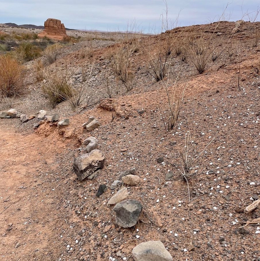
We saw several of these beautiful buttes along the trail to Owl Canyon. The creek flowing below the butte at lower left is Las Vegas Wash, a 12-mile-long arroyo that channels most of the excess water from the Las Vegas metropolitan area into Lake Mead. The wash contains water from urban runoff, reclaimed water from golf courses and parks, and stormwater; in short, it’s probably best to not dip your tin cup in it for a cool, refreshing drink – although the plants and rocks of the wash do filter a lot of the contaminants out of the water before it reaches Lake Mead. This photo was taken perhaps a half-mile from the trailhead, which was a boat ramp that used to provide watercraft with access to Lake Mead. More on that later.Thousands of these small white mollusk shells can be found in several locations along the Owl Canyon trail. They point to a time, years ago, when this entire area was covered by a vast body of water: Lake Mead, which, when it’s full is about 60 percent bigger than the area covered by the city and county of Denver. As recently as the 1980s, mollusks like these were free to frolic or fritter away their days or whatever it is that mollusks do. Now, every foot of the trail we were on is high and dry.
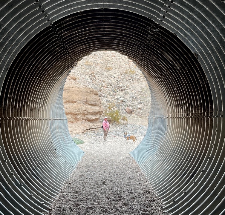
Here we see an intrepid hiker and her ill-behaved dog (it’s Nancy and Gunther) approaching the mouth of Owl Canyon, about a mile and a half from the trailhead on the boat ramp to the west. The canyon can also be accessed by a trailhead resulting in a shorter hike (2.2 miles out and back) coming from the northeast, but we wanted a bit more of a challenge for this first hike of 2024.
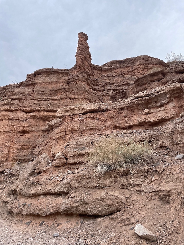
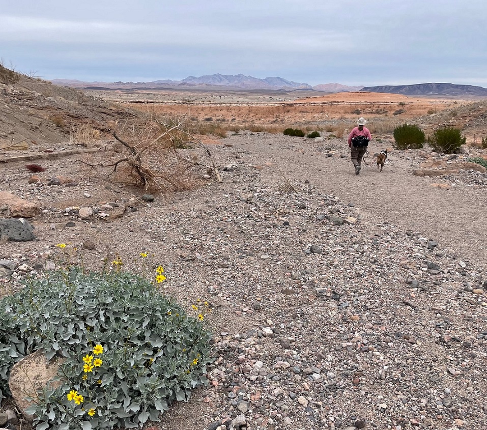
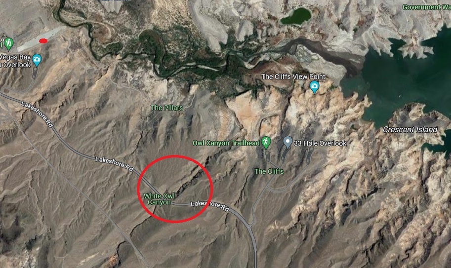
As you can probably tell from the earlier photos, it’s rather arid in the Lake Mead National Recreation Area (it’s in a literal desert, the Mohave, and the region is a convergence of the Mohave, Great Basin, and Sonoran deserts). Depending on which resource you use for reference, the area gets between 4 and 6 inches of precipitation each year. Except for a great blue heron, a small family of mallard ducks, and a large flock of goldfinches, we didn’t see much in the way in wildlife on the day’s hike. However, we did see some examples of desert plants that we hadn’t yet encountered on our travels. This is a specimen of desert stingbush (Eucnide urens), also known as velcro plant. It’s found in the desert regions of the southwestern United States and Baja California. It looks a lot like holly leaves seen around the December holiday, but, true to its name, the serrated leaves have stinging hairs to protect the plant from browsing animals. It’s yet another desert plant one wouldn’t want to lick (although the desert bighorn sheep native to the area seem to like them quite a lot).The walls of the canyon, which were under the waters of Lake Mead for many years, is made of a conglomerate of many different kinds and sizes of rocks, ranging from particles of sand to basalt stones the size of footballs or larger. Owl Canyon existed before Lake Mead; it was carved by an intermittent watercourse to create a winding natural path through the desert.The previous photo of the canyon walls’ conglomerate was taken near a spot in the canyon where we stopped for lunch. This photo was taken from the same spot. It shows Gunther alertly listening to Nancy about further instructions regarding the hike, especially to be constantly aware of impending threats from wildlife. (He’s really just waiting for Nancy to offer him some of her tuna salad sandwich; ultimately, he was disappointed to be denied the same.) The bandana he’s sporting around his neck was acquired gratis from a pet grooming service in Idaho over the summer; it looks like I neglected to iron it before we left on that day’s hike.Owl Canyon gets its name from the many holes in the rock walls that have eroded away, providing perches for owls and other roosting birds. Walking through its winding course was a ton of fun, although Gunther appeared to be ready to leave at any time.Of course, Gunther was right to be terrified. One drawback presented by the canyon’s winding rock walls was the inability to see anything around an upcoming bend, such as these remarkable multi-stone sculptures located just before a culvert in the canyon, until they suddenly appear before you. They were encountered on our return path through the canyon; they weren’t there when we walked through the culvert earlier and gave us something of a start. Their sudden appearance shall forever remain a mystery. (Seriously, a family also walking through the canyon must have put quite a bit of work into stacking these stones, and they did it in pretty short order. Park managers are strict when it comes to building even small piles of rocks: like graffiti on rock walls or otherwise defacing natural resources, despite how cleverly they’re designed, putting these formations together is forbidden.) That’s Lakeshore Road above the culvert.Here are Nancy and Gunther on the other side of the culvert pictured above. Walking through its galvanized confines as we hiked underneath Lakeshore Road was an interesting experience. I found, to Nancy’s delight, that it provided quite an echoing experience. There are two culverts in Owl Canyon; they allow seasonal water runoff to continue on its natural course through the canyon on its way to Lake Mead.Erosion from water and wind creates some spectacular rock carvings. Vertical formations like this, like the much larger butte pictured earlier, are created when the erosional forces of water and wind take away rock material surrounding a structure, but the formation itself is protected on its top by a layer of less permeable rock. I’d guess that this formation at the top of the canyon wall is 12 to 15 feet tall.Nancy and Gunther emerge from the canyon and prepare to return to the trailhead; Gunther, in particular, appears pretty happy to be out. That’s a brittlebush (Encelia farinosa) plant in the lower left, displaying its bright yellow blossoms on this early January day. Perhaps unsurprisingly, brittlebush is a member of the sunflower family.On our walk back to the trailhead, we saw this striking shrub we hadn’t noticed while hiking to the canyon. I inset a closeup of the plant’s leaves in the lower right. It’s a pretty plant, isn’t it, with its deep red limbs and attractive dark green and juniper-like leaf structures? Don’t be fooled! This is the scourge of the southwest, an invasive plant called tamarisk (Tamarix ramosissima) that’s native to Europe and Asia. Land and river managers throughout the southwestern United States spend a lot of resources trying to control the spread of tamarisk, the flowers of which each contain thousands of tiny seeds. Younger tamarisk plants compete with native plants for water along riverways; tamarisk doesn’t grow well in shade, so if the native plants are able to outgrow tamarisk (which can grow to heights of 25 feet in full sun and with sufficient water), the natives will usually win out. This particular plant was growing quite a ways from Las Vegas Wash.This is a view of the length of the boat ramp that now serves as a parking lot for a couple of hiking trailheads, including the Owl Canyon Trail. I took this photo as we were driving away from the trailhead. You can barely make out the white paint on a couple of vehicles parked on the right side of the ramp near its end. Las Vegas Wash is just beyond the end of the ramp. When the lake is full, a lot of this ramp would be underwater. Keep scrolling to see what it would take to get this boat ramp functional for launching boats into Lake Mead again.Here’s some perspective of how low Lake Mead is. This is a screenshot from Google Maps, using satellite imagery taken from about 250 miles above the earth, of the area in which Nancy, Gunther, and I hiked. The boat ramp pictured in the photo above this screenshot is the small gray strip in the upper left corner; we parked the Goddard’s six-wheeled towing unit approximately where the red dot is. Owl Canyon is in the red circle; we hiked from the boat ramp, to and through the canyon, and back again. Las Vegas Wash is the creek at the top of the image flowing into Lake Mead in the upper right corner; when the lake was full, it extended west all the way to cover a lot of the boat ramp on the left side of the image. In short, the end of the boat ramp is at least three miles from the current waters of Lake Mead, and the lake would still need to fill much more in order to actually launch a boat from the ramp. When we finished our hike we happened to meet an construction engineer on the boat ramp who was doing some preliminary evaluation to prepare for its eminent demolition and extraction of the concrete, rebar, and other materials. As he told us, “This lake isn’t filling in our lifetimes.”
It’s easy to think that it’s not the end of the world if Lake Mead continues to dry up: the Colorado River flowed freely through this area for millions of years, supporting all kinds of native plant and animal life. But that’s not the world in which we currently live, and the disappearance of Lake Mead would be an absolute catastrophe: without constant flowing water to turn Hoover Dam’s turbines, many metropolitan areas in the southwest, like Phoenix, Las Vegas, and Los Angeles (to say nothing of the many thousands of smaller cities in the region), would suffer calamitous losses of electricity as well as a reliable source of water. Simply put, water impoundments like Lake Mead (and, to lesser but still vital extents, Lake Powell and Blue Mesa Reservoir upstream) make habitation of the southwest possible. Ain’t nobody living in Phoenix or Las Vegas in the 120-degree temperatures of July without air conditioning provided by electricity, to say nothing of being able to turn a faucet and expect water to come out.
It’s sobering to think that every step we took on this hike was once well underwater in Nancy and my lifetimes. Fortunately, smart and committed people are working on ways to continue developing and encouraging water conservation in the American southwest, but committed people will also need to actually take those steps in order to keep water flowing through Lake Mead.