Grand Staircase-Escalante National Monument is big – really big. In fact, although it’s the seventh-largest U.S. national monument by size, it’s the biggest in the country that’s not either entirely in or adjacent to an ocean. At 1.87 million acres (just over 2,900 square miles), the national monument is nearly twice as big as the entire state of Rhode Island, and just a tad bigger than the state of Delaware.
This area in southern Utah is vast, and it is remote: it was the last part of the contiguous United States to be mapped by the federal government. Grand Staircase-Escalante National Monument was authorized by President Bill Clinton in 1996. This is also one of the more contentious federal properties; President Donald Trump effectively halved its acreage in 2017, and then President Joe Biden restored it to its current size in 2021. It is the first national monument to be administered solely by the Bureau of Land Management (BLM).
(A brief sidenote: the U.S. government’s holding of lands, especially at the levels of national monuments and especially those in the western United States, is criticized by some groups and lauded by others. Much of these lands frankly isn’t good for anything except looking beautiful and supporting native plants and animals – which, in the eyes of some, is more than enough reason to provide federal protection. Other groups are interested not so much in the lands themselves, but what’s under the lands’ surfaces: minerals, petroleum, and other extractive materials. Everyone from kayakers to native Americans to miners to anglers to ranchers to tourists wanting a scenic drive has an opinion on what should and shouldn’t happen on these lands. U.S. presidents are able to establish and change landholdings under national monument status as they see fit; acts of Congress are needed to establish or change national parks. I’m someone who enjoys nature quite a lot, but I also realize that I use minerals and petroleum extracted from the earth nearly every minute of every day – in the laptop I’m typing on, in the fifth-wheel trailer in which we live, and in the iPhone and digital camera with which the following photos were taken. You most likely are equally dependent on those extractive resources. As with most issues in life, it takes a balance. Grand Staircase-Escalante National Monument is especially contentious because county and state governments also want to maintain at least some control over what can and can’t happen within its borders.)
(That sidenote was less brief than I’d expected.)
Anywho, Grand Staircase-Escalante National Monument takes up a sizable chunk of southeastern Utah. It protects three major areas: the Grand Staircase, the Kaiparowits Plateau, and the Canyons of the Escalante. The Grand Staircase is so named because of its stepped appearance if viewed from the side: from west to east, the landscape drops in elevation in enormous eroded and even layers. The steps drop, west to east, in cliffs measured in hundreds of feet. The area represents 400 million years of geologic development.
The views at Grand Staircase-Escalante National Monument are simply spectacular. The monument is bordered by Bryce Canyon National Park on its western edge and by Glen Canyon National Recreation Atea on its eastern side.
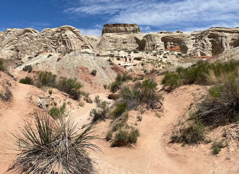
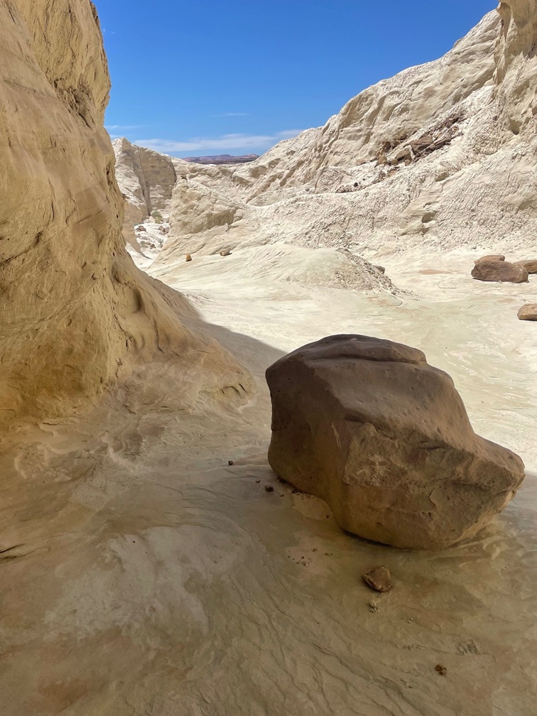
One fun thing to do in these federally protected lands is to go on a hike, and that’s what Nancy and I did in late May of 2023. The Toadstool Trail leads to some wonderful rock formations and other features of this otherworldly environment. In its easy out-and-back 1.5 miles, one can see rocks eroded from water, rain, and other elements to create some pretty stunning scenery. We happened to visit the area when a number of flowering desert plants were in bloom, which was great to see.
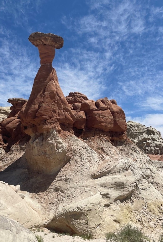
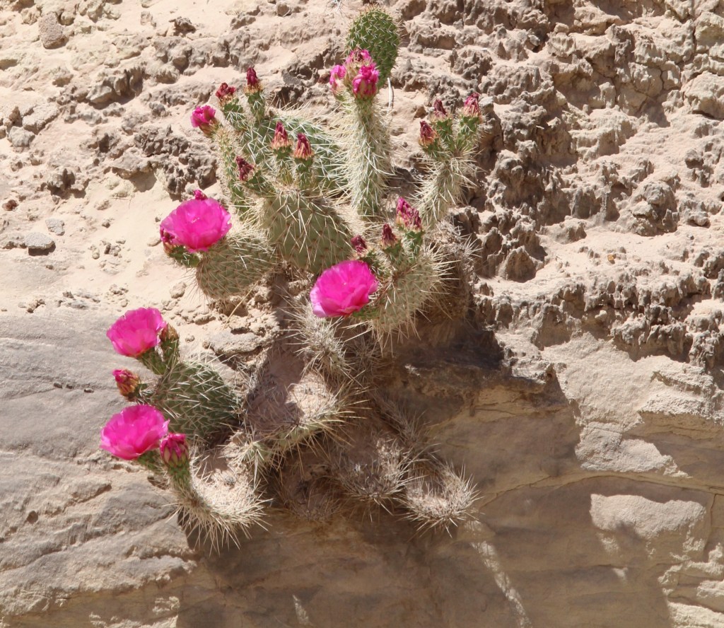
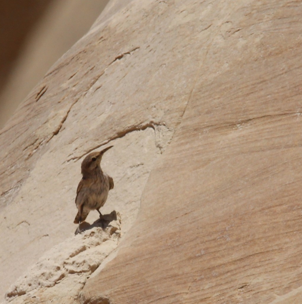
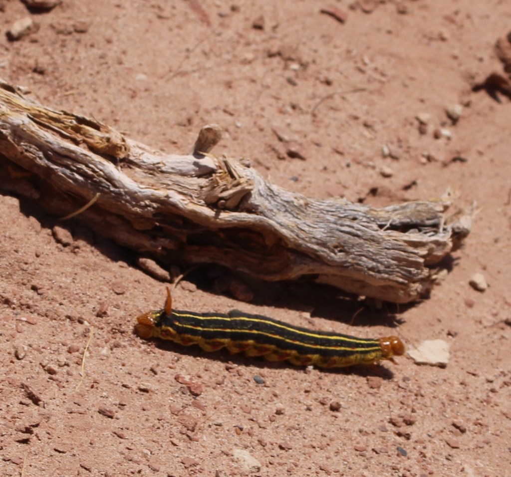
We visited the national monument on a beautiful day in late spring, when there was little chance of rain, but there was plenty of evidence that the area receives considerable amounts of moisture at times. This ravine was cut by a seasonal watercourse; the hiking trail is at the far right of the photo. Note the coloration of the different layers of rocks in the cliffside.This pretty flower is a sego lily (Calochortus nuttallii), which happens to be the state flower of Utah. We saw quite a few of these blossoms, which can measure up to three inches across, on the hike. “Sego” is believed to derive from the Shoshone name of the plant.There’s a lot going on in that cliff, not the least of which is the wavy nature of the rock layers on the left. I took this photo from a U-bend in the trail (it continues on the left and right of the photo) and you can see some hikers near the center of the photo.This is a TALES OF THE GODDARD LIZARD ALERT. I’m not an expert on reptile identification (I’m not really an expert on anything, come to think of it), but I believe this to be a common side-blotched lizard (Uta stansburiana). They grow to a length of about 2.5 inches not including the tail, which is often longer than the body. Judging from the Wikipedia page on these little rascals, a lot of the scientists have spent a lot of time observing this species. This is a lizard that can safely lose its tail to escape a predator, but that comes at a terrible cost: loss of social status within a group of other common side-blotched lizards. We saw several of these lizards and all still had their tails, so we were among the elite. This isn’t the first lizard species to live in the area; researchers have found fossils of several different dinosaurs within the borders of the monument.This is the largest rock formation from which the Toadstools Trail gets its name, and it’s plenty spectacular. If I had to guess, I’d say the column is about 25 feet tall. Formations like this occur when softer rock under harder, denser rock is eroded away. These are basically small buttes, with more material underneath the surface caprock taken away by water, wind, and other erosional forces, to form a toadstool formation.I thought this rock wall was interesting because it shows not just the colors of the different rock layers, but the different density of the layers as well: note the edge-on layers of rocks upon which less-dense layers, which are disintegrating faster, were deposited over millions of years.The bright blossoms of this plains pricklypear (Opuntia polyacantha) were hard to miss in an otherwise tan-colored environment. The flowers of this species of cactus can be yellow, red, or magenta, as on this specimen. These plants provide a source of food for quite a few animals, like prairie dogs and pronghorns, and many people enjoy eating the fruit (if animals haven’t gotten to them first) once the blossoms are spent.Although the larger toadstools are very impressive, the rock formation – a column supporting a wider, flat cap of harder stone – is fairly common in the area. They make for some interesting viewing opportunities.This is Coulter’s lupine (Lupinus sparsiflorus), also known as Mohave lupine or desert lupine. The plants grow to a maximum height of about 16 inches. We’ve seen this pretty flower elsewhere in the deserts of the western United States; it, along with the other plants that happen to be flowering at the time, provides a nice pop of color.This blurry photo is unfortunately the best of three I took before this rock wren (Salpinctes obsoletus) took off to raise havoc somewhere else. This species, fairly common in the western part of the country, is adapted to cling to rock faces while hunting for insects and spiders.Shortly after we’d started this hike, another hiker suggested that we continue walking past the main toadstool formations for some really nice views, more toadstools, and balanced rocks. We took his advice, and we’re glad we did. I’m going to guess that it’s six or eight miles to the horizon. Here we see a lone hiker (it’s Nancy) looking west; Kanab, Utah, is about 40 miles thataway.In this very arid environment, anything that moves and (especially) is not some shade of brown quickly catches your eye. This caterpillar is the larval stage of a really nifty moth called the white-lined sphinx, or hummingbird moth (Hyles lineata). The adult version of this species can be easily mistaken for a hummingbird as it hovers over blossoming flowers. The species is very common from central America up into Canada, including most of the United States. The spike at the back end of the caterpillar isn’t a stinger but it does give this larval form another name: hornworm. They aren’t harmful to humans but given a big enough population, these voracious eaters can destroy cultivated crops and flowers. Conversely, the adult moth form is beneficial for plants because of its ability to pollinate while feeding.That hiker who suggested that we continue our walk past the main formations was absolutely right, and we were able to see some really pretty toadstools and long vistasThe yellow blossom on the left is red dome blanketflower (Gaillardia pinnatifida), while the white blossom belongs to a flowering plant called birdcage evening primrose (Oenothera deltoides). Because they don’t require a lot of care, blanketflower species are very popular in home flower gardens – I planted some of them in our xeriscaped lawn in Denver.The cliffs, toadstools, balanced rocks, and other rock formations in the national monument were created by erosion and plenty of time. I’m including this photo to show how even tiny trickles of water coming down a rock face can create really interesting designs.Native American cultures arrived in what is now the national monument around 1,500 years ago. There are hundreds of petroglyphs that document those peoples’ existence in the area, and the rock in the foreground looks to have two of them. This was at the mouth of a very short canyon eroded into a cliff wall.Here’s a closeup of one of the petroglyphs on the rock pictured above. I have no reason to think it’s not genuine, but I sure can’t think of any horned quadrupeds that also have long tails. Maybe it’s a depiction of something else entirely.On the way back to the trailbead, another hiker with a digital camera and long lens was as excited as me to see this bird about 50 yards away from us. We couldn’t identify the species at that distance, so I was certainly looking forward to getting back to the Goddard and looking at the picture on a larger screen. “What kind of exotic birds could possibly live in this remarkable desert environment?” thought I, taking picture after picture of a bird I couldn’t make out through the camera lens. Turns out, it’s a house finch (Haemorhous mexicanus) which is common all over the country so it’s not nearly as exciting as I first thought. However, I’ve gone some days without seeing any birds at all and those days aren’t any fun so I’ve learned to appreciate all the birds I see, no matter how common they are.This photo was not taken on the Toadstools Trail, but I wanted to include it in this posting about Grand Staircase-Escalante National Monument. It shows a spectacular bluff above a former townsite called Paria, which was a Mormon settlement from 1870 to 1929. The town was abandoned because it kept getting inundated by floodwaters. It must have been a tremendously hard way of life, separated from other communities by dozens of miles, but at least the view was pretty good.


Leave a comment