El Malpais (pr. el-mal-pie-EES) National Monument, located near the town of Grants in northwestern New Mexico, showcases a number of different geological features in its nearly 180 square miles – but it’s best known for its impressive lava flows dating from 60,000 to only 4,000 years ago.
While Native Americans have lived in the El Malpais area for 12,000 years, early 17th-century Spanish explorers coming north from Mexico found the region nearly impassable by their horse-drawn wagons and carts. Those explorers gave the region its name, which means “the bad land” in Spanish and refers to the rocky topography left behind by the extensive lava flows.
El Malpais National Monument was established on Dec. 31, 1987, and about 100,000 people visit it each year.
We camped for a week in Grants and visited several different features of the national monument. The highlight, however, was a great hike that took us to the top of a cinder cone from which much of the monument’s lava had flowed.
The El Calderon Trail is located on the western side of the national monument – it happened to be only a 20-mile drive from Grants. We’re still trying to adjust to being on trails that aren’t in Colorado: there were two other vehicles in the trailhead’s parking lot when we arrived at 10 AM, and in the entire course of the 5-mile loop hike, we saw nearly as many dogs (two) as we did people (three).
This iGoogle Maps satellite image, in which a quarter-inch represents two miles, shows nearly the entirety of El Malpais National Monument. The monument’s visitor center fs indicated at the top, and just to the left is the town of Grants, New Mexico, where we parked the Goddard for a week in April 2024. Grants is on Interstate 40 about halfway between the Arizona/New Mexico state line and the city of Albuquerque, New Mexico. Everything represented in dark greenish-black in the lower two-thirds of the image is basalt, or lava rock; the greenish hue is provided by plant life amongst the basalt. The town of Grants, too, is surrounded by basalt.
Shortly after the trailhead, the El Calderon trail passes by several caves that are actually lava tubes and are now home to bat populations. Lava tubes are formed when flowing lava exits an existing lava vent covered with a roof of lava rock, leaving behind a cave-like structure.
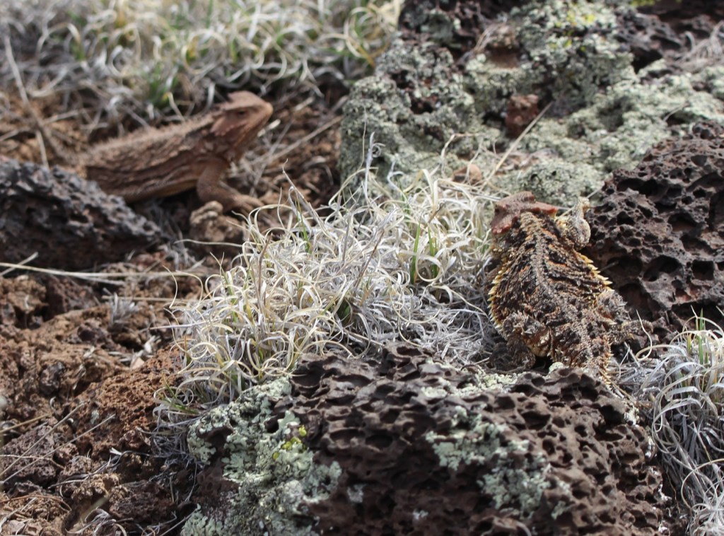
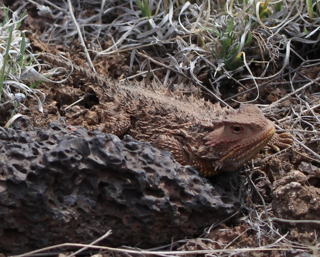
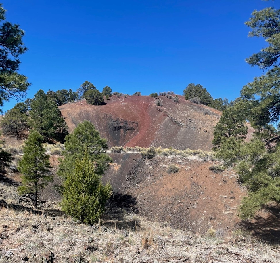
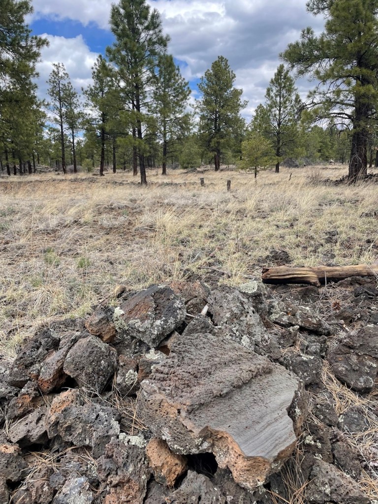
Here we see a brave hiker (it’s Nancy) at the entrance to Bat Cave in the national monument. This lava tube is a summer home for thousands of Mexican free-tailed bats that emerge at night to hunt for insects. There is still evidence of a guano mining operation in Bat Cave; bat droppings are high in nitrates and therefore valuable as fertilizer. We learned at Mammoth Cave National Park in Kentucky that guano was also once used in the production of gunpowder. To protect the flying mammal population, Bat Cave in El Malpais National Monument is closed to human visitors.Much of the El Calderon trail looks like this: relatively flat, with expansive views, through a moderately wooded forest with several different species of pine trees and evergreen shrubs.There weren’t many wildflowers in bloom when we hiked the El Calderon Trail on April 20, but we’d just missed the blossoms of the tree cholla (Cylindropuntia imbricata). Also known as cane cholla, this cactus typically grows to a height of 3 feet, but can reach 15 feet. The flowers are a very bright magenta color, and the yellow fruits, shaped roughly like a pinecone, can last on the plant for a long time. They apparently don’t taste great, but the Native Americans of present-day Arizona and New Mexico did use them as a food source.This is a TALES OF THE GODDARD LIZARD ALERT. I’d walked by this pair of horned lizards on the lava rocks lining the trail without seeing them but they didn’t escape the notice of Gunther, who Nancy had on a leash behind me. I was able to get several photos of them before we moved on down the trail. Their camouflage really is amazing – if they hadn’t moved as I passed by, Nancy said Gunther probably wouldn’t have seen them either.This is a close-up of the lizard in the background of the above photo. There are 21 species of horned lizards in the world, 15 of which are native to the United States. Five of them reside in El Malpais National Monument, and, without being familiar with any of them, I’ll just say this is one of those five species (although based on the coloration and locality I’m leaning toward a greater short-horned lizard, or Phrynosoma hernandesi). Horned lizards are often called horned toads, but they’re not toads or even amphibians at all: they are reptiles. It’s somehow reassuring to know that dinosaurs still walk among us, however small they may be. Females of the short-horned lizard species grow to about 7 centimeters (2.75 inches) SVL, while males grow to only 5 centimeters SVL. What’s SVL, you ask? I had to look it up as well: it’s an abbreviation for a herpetology term called snout-vent length (basically the length of the lizard not including the tail).The entire trail was lined with readily available lava rocks, which made for interesting viewing while hiking because of all of the different textures. Each was different, but the trailbuilders used rocks that were roughly a foot in height and width. One can only imagine the scene 115,000 years ago, when these rocks were being created: what did it look like, sound like, and smell like?We’ve seen plenty of lava tubes in Hawaii, Idaho, and now New Mexico, but I don’t think we’ve ever seen a distinct lava trench. They are formed in the same way as lava tubes, but the roof of the tube collapses soon after the lava of the tube cools. Water collects in the bottom of these trenches, allowing trees and other foliage to grow larger than their counterparts outside the trench.This is the side of the El Calderon cinder cone, from which rivers of magma flowed about 60,000 years ago to create immense rivers of lava that found their way 20 miles north to the present-day town of Grants. A cinder cone is formed when gravel-sized bits of lava are shot hundreds of feet into the air from a volcanic vent in the ground. The billions of tiny cinders fall back to earth and eventually form a cone-like structure; El Calderon is 300 feet high. The two different colors of cinders – red and black – indicate different mineral composition and different eruption periods. The trail includes an optional loop around the top of the cinder cone — it was a 300 foot gain in elevation, but the views were well worth the effort.This is a view looking northeast from the top of the El Calderon cinder cone (the side of the cinder cone pictured above is directly below this position). The red cinders contain high levels of oxidized iron: essentially, rust. On the far left of the photo one can just barely make out the snow-covered top of Mount Taylor (elev. 11,305 feet), about 30 miles away on the other side of the nearer hills. Mount Taylor is an extinct volcano that last erupted about 1.5 million years ago – long before the volcanic activity on El Malpais National Monument occurred. It is a mountain sacred to a number of Native American pueblos, including the Acoma, Zuni, Hopi, Laguna, and Navajo.This is a view looking down into the interior of El Calderon, fairly close to where the previous photo was taken but in the opposite direction. It’s a peaceful basin filled with pine trees and grasses now, but it was the source of all of those lava cinders shooting upwards into the sky when the volcano was active 60,000 years ago. El Calderon translates to “the cauldron” in Spanish.Time for lunch – trailside! We heard, but could not see, a couple of different birds singing in some nearby pines during our lunch. Afterwards, I got a couple of pictures of them. The pictures didn’t turn out well at all (they were still far away and the skies were overcast), but it turns out that they were gray flycatchers (Empidonax wrightii), and, judging by the grass in their beaks, they were building a nest.We saw these white growths on nearly every rubber rabbitbrush (Ericameria nauseosa) plant we saw on the hike. Nancy asked what they were and I replied that they were spider egg cases, each just waiting to pop with up to 100 individual spiderlings. She refused to believe me, which was probably the right thing to do, but it meant that I later had to look up what they really are. It turns out my wild guess wasn’t very far from the truth: they’re called galls, and they are home to larvae of a fruit fly. The galls, produced by the plant’s reaction to irritating chemicals introduced by the parasitic insect, act as both a home and a food source for the larvae. They don’t appear to harm the rabbitbrush plant at all.It’s a little difficult to make out in this picture, but there’s a tree species we weren’t expecting to see in northern New Mesico on the other side of the fallen log, just left of center. It’s an aspen tree, which is made possible by what the scientists call “the edge effect,” or additional moisture that collects along the area where lava fields meet conventional landscapes. The edge effect allows plants that need additional moisture, like aspens, to thrive in otherwise harsh environments.I thought the smooth side of this hunk of basalt was interesting: it indicates that the lava was moving fairly quickly as it cooled. Lava fields, after they cool and begin to erode, make for fairly good habitat for plants: the basaltic rocks hold a lot of water and trap a good variety of airborne seeds.The skies above us unfortunately still chose to be overcast when we saw this western bluebird (Sialia mexicana) perched on an oft-used branch, but the bird’s bright colors still impressed us. Western bluebirds are members of the thrush family, and their diet consists of worms and berries found on the ground as well as insects plucked from the air.The trail on the right side of this photo is the 2,700-mile-long Continental Divide Trail, which meets and shares some distance with the El Calderon Trail. If one were to follow that path, one would wind up at the Canadian border with Montana. We elected to continue on our loop to the El Calderon trailhead instead.
The hike to El Calderon was one of the more rewarding trails Nancy and I have been on in a long time: fantastic views, lots of fascinating geologic features, a good variety of plants, and a bit of wildlife to observe.
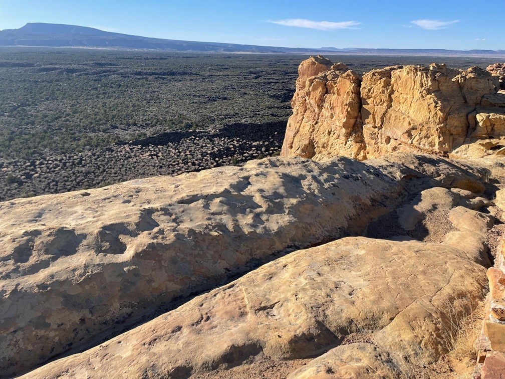
There is a lot of geology to appreciate about El Malpais National Monument, and not all of it has to do with lava. On a weekday evening, Gunther and Nancy and I drove to the east side of the monument to see two sandstone features: La Ventana and a sandstone bluffs overlook.
About 160 million years ago, the El Malpais area looked a lot like today’s Sahara Desert: covered with hundreds of feet of sand that, compressed by other layers of sediment, eventually formed sandstone. This arch, formed by the weathering effects of freezing and thawing water trapped in the sediment over millions of years, is 135 feet across and only 25 feet wide at its thinnest point. Spanish explorers called this arch “La Ventana,” or “the window.” It is one of the largest natural stone arches in the state of New Mexico.This is a sandstone bluff overlook that provides great views of the basaltic lava flows hundreds of feet below. More than 200 volcanic vents have been identified in the national monument, and this sandstone is tens of millions of years older than any of them.
Nancy and I both have more than a passing interest in geology, and especially volcanoes, so El Malpais National Monument was a great place to spend a week. We spent the summer of 2023 surrounded by volcanic features in Idaho, and it was fun to once again be amongst these reminders in New Mexico that our planet continues to reshape itself all the time.
Nancy and I both liked this hike quite a lot — it was good to be among trees again, for one thing, after having been in the Nevada and Arizona deserts for nearly half a year (not that they are without their appeal as well).


Different landscape than you’re used to hiking. Very beautiful. Thanks for pictures.
<
div dir=”ltr”>
<
blockquote type=”cite”>
LikeLike
Nancy and I both liked this hike quite a lot — it was good to be among trees again, for one thing, after having been in the Nevada and Arizona deserts for nearly half a year (not that they are without their appeal as well).
LikeLike