
September 28, 2024 – Near Pagosa Springs, Colorado

The scientific pursuits of geology, archeology, and astronomy combine in a number of interesting ways at Chimney Rock National Monument, located about 20 miles of Pagosa Springs in southwestern Colorado. In late September 2024, the Goddard was parked for a couple of weeks in Pagosa Springs, allowing us to enjoy the spectacular fall colors of aspen trees as well as a visit to Chimney Rock National Monument. We joined a geology-focused tour of the monument led by a volunteer guide, a former geologist in the oil and gas industry. In addition to learning about the rock features of the monument, we also learned about the history of the human habitation of Chimney Rock and visited the highest-in-elevation ancient Pueblo in the American Southwest, the Great House.

Between the years 925 and 1125, more than 2,000 Pueblo Native Americans lived in the Chimney Rock region and, although no more than about 250 people called it home at one time, they made it a substantial settlement for two centuries. The inhabitants built a number of stone and timber structures that are still standing today, and they traded goods with other Pueblo communities up to 150 miles away. Today, archaeologists know of 200 ancient structures collected within eight distinct villages at Chimney Rock.
Initial archeological investigations began in the 1920s by J.A. Jeançon, a Smithsonian Institution-trained archeologist working on behalf of the Colorado Historical Society, and his assistant, Frank Roberts; they and their crew surveyed and mapped dozens of structures and found thousands of artifacts.
Today, the U.S. Forest Service, which manages Chimney Rock National Monument, is leaving many archeological sites undisturbed out of respect for existing Puebloan and other Native American cultures, and with the understanding that less-invasive archeological techniques may be developed in the future. More than two dozen Native American tribes have an affiliation with Chimney Rock.
The monument, surrounded by the Southern Ute Indian Reservation, is closed to the general public each year from September 30 to May 15. The closure allows Native Americans to access the site for private ceremonial purposes, and the Chimney Rock area is also a major thoroughfare for elk migration.
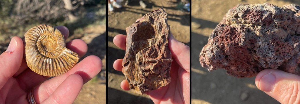
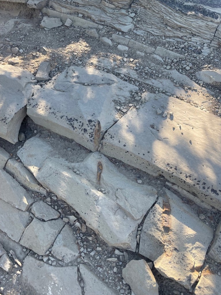
The true importance of Chimney Rock lies, of course, in its ties to ancient and current-day Native Americans. But from a geologic perspective, the story of Chimney Rock begins, seemingly as do so many on this website, with a great inland sea. One hundred million years ago, much of present-day North America was under a shallow but vast sea that connected the Gulf of Mexico to the Arctic Ocean. At its largest size, the Western Interior Seaway stretched from today’s Rocky Mountains in the west to the Appalachian range in the east. At its deepest points, it was only about 3,000 feet from the waves on top to the sea bottom – very shallow for a sea. The size of the sea varied widely over the course of its 34 million years of existence; it finally drained away for good about the time of the end of the Cretaceous Period, or 65 million years ago when dinosaurs ceased to rule the earth.
While it was relatively shallow, the Western Interior Seaway’s 3,000 feet of water depth carried a lot of compression capability. Clay at the bottom of the sea, as well as dead plants and animals, accumulated over the eons to build a 1,000-feet-thick layer of mud. That layer would solidify, over millions of years of water weight pressing upon it, into a dark gray layer of rock called Lewis Shale. When the western part of the American continent began to rise, the waters of the inland sea drained away to leave shorelines of sand and tidal flats. Dry periods alternated with years upon years of wetter conditions, leaving layers of coal and fossilized animal skeletons.
About 40 million years ago – 26 million years after an asteroid impact killed all of the non-flying dinosaurs as well as a goodly amount of other life on Earth – volcanoes began erupting in the Four Corners area of Colorado, Utah, New Mexico, and Arizona. This activity built the Colorado Plateau, a huge high-desert expanse of the southwestern United States covering 130,000 square miles of those four states, roughly centered in the Four Corners area.
The erosional forces of wind and water began to have their way with the soil covering today’s Companion Rock and Chimney Rock, and then glaciers from the last Ice Age of 4 million years ago carved deeply into the former mud of the inland seafloor, now compressed into shale. Finally, the glaciers melted and the resulting floodwaters exposed sandstone – formerly the beaches of the receding inland sea from tens of millions of years earlier but compressed into a rocky layer – and eroded away nearly all of that sandstone layer with the exception of Companion Rock and Chimney Rock. The scientists believe that the two sandstone features have been exposed for about 25,000 years, protected by what was probably the thickest and hardest layer of sand during the time of the Western Interior Seaway and is now a layer of sandstone more resistant to erosion than other rocks had been. However, they too, with the relentless work of water and wind, will gradually fall to the valley below.


Jeançon began his excavation of the Great House Pueblo in 1921. He noted that some of the walls were still 14 feet tall. The building contained at least 35 rooms and two kivas, the round structures believed to be the center of the ancient Puebloans’ spiritual and perhaps social lives. An archeologist has estimated that to build a structure of this size and complexity, in addition to the 6 million rocks, the builders would have needed 5,000 log beams, 25,000 tons of water, and 25,000 tons of dirt to make an adobe mortar. All of these materials would have had to have been carried up the steep trail by hand.
Considering all of the labor needed to build Great House and the many other structures, one is left with the question of why the residents stayed here for only two centuries. There are three prevailing hypotheses for the ancient Puebloans’ departure: it’s possible that the area was depleted of food and other resources; societal changes or perhaps warfare made it in the residents’ best interests to leave; or the community, representative of other Puebloan cultures of the time, simply decided that it was time to find a new home. Whatever the reason for their departure, it’s believed that the residents of Chimney Rock, along with many other ancient Puebloan communities, moved south into present-day New Mexico and Arizona; their descendants can be found today among the members of the Navajo, Hopi, Zuni, and other Native American tribes.

That covers some of the geology and archeology at Chimney Rock National Monument; let’s move on to the skies above. Nancy and I learned a new word the day we visited the monument: archeoastronomy. This vowel-heavy construction refers to the study of the ways in which ancient cultures studied the skies and how they used that information to guide many of their day-to-day and seasonal decisions, including when to plant crops and conduct spiritual ceremonies. Around the world, very old cultural sites, like Stonehenge in England and hundreds of temples in Egypt, show that ancient peoples were keenly aware of the movement of the sun, moon, planets, and stars.
Observing the skies and the objects contained in the vast expanse above also played a major role in the ancient Native Americans’ religious lives. In North America, evidence of the significance of celestial movement to Native American cultures can be found in many places, including at Chaco Canyon and at Chimney Rock.
The most significant alignment of celestial objects and Earth-bound structures at Chimney Rock is known as the Northern Major Lunar Standstill. (That was another term and concept new to Nancy and me, neither of whom are anywhere close to unfamiliar with astronomy, but I guess that’s a big reason that we’re doing this: each time Nancy and I leave the Goddard to visit a museum or national park, we ask each other, “Are you ready to do some more learnin’?”)
Many will be aware that the rising and setting of the sun appears to move across the horizon as the year progresses: on the day of the summer solstice it appears to rise and set in its northernmost latitude (and makes for the longest day of the year in the northern hemisphere), and then the sunrise and sunset appear to occur further south each day until the winter solstice, making for the shortest day of the year. It then appears to move north again to complete the second half of the solar cycle.
The moon has a similar cycle, appearing to rise at different locations from north to south like a pendulum over the course of a month. The Northern Major Lunar Standstill, or MLS, occurs on a recurring cycle of 18.6 years when that pendulum of the moon’s rise appears to stay in the same location on the horizon for a period lasting about 16 months.
Here’s the significance of the MLS to the manmade and natural stone structures at Chimney Rock: during the lunar standstill and when viewed from the Great House Pueblo, the moon appears to rise between Companion Rock and Chimney Rock. Archeoastronomers don’t know this for an absolute certainty, but it appears that the Great House was built where it was so that its ancient Puebloan residents could observe this event that occurs on a cycle of just under two decades. The years AD 1076 and 1093, when the structure was built and later expanded, were both years in which lunar standstills occurred. It’s quite possible that many ancient Puebloans from around the Four Corners region traveled to the Great House to view this powerful spectacle alongside the residents of Chimney Rock.
As it happens, in late 2024 the MLS was nearing the end of its cycle at Chimney Rock – our U.S. Forest Service geologist guide showed us pictures on his cellphone he’d taken of the moon rising between the two rocks just a few nights before our visit. We briefly lamented not being able to see the event ourselves, but the guide noted that very few people are allowed to be at the Great House at night. It’s of extraordinarily powerful spiritual significance to modern Puebloans, of course; it’s also incredibly dangerous to walk the trail to the Great House at night because of the trail’s position on a very thin ridge. The Forest Service and its academic partners in astronomy have a camera situated at the Great House, and the transmission showing the moon’s rise between Companion Rock and Chimney Rock is seen by many people down at the monument’s visitor center.


Leave a comment